Bridge Statistics for Crittenden, Kentucky (KY)
Condition, Traffic, Stress, Structural Evaluation, Project Costs
- National Bridge Inventory (NBI) Statistics
- 13Number of bridges
- 131ft / 39.5mTotal length
- $147,000Total costs
- 164,020Total average daily traffic
- 28,179Total average daily truck traffic
- National Bridge Inventory (NBI) Registered Bridges for Crittenden
- No street view available for this location
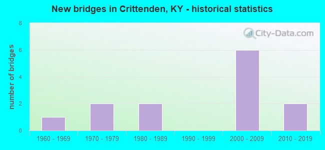
- New bridges - historical statistics
- 11960-1969
- 21970-1979
- 21980-1989
- 62000-2009
- 22010-2019


- Bridge Condition - Deck
- 60.0%Good
- 30.0%Satisfactory
- 10.0%Fair

- Bridge Condition - Superstructure
- 50.0%Good
- 30.0%Satisfactory
- 20.0%Fair

- Bridge Condition - Substructure
- 30.0%Very good
- 20.0%Good
- 30.0%Satisfactory
- 20.0%Fair

- Bridge Condition - Channel
- 83.3%Good
- 16.7%Fair
Find on map >> Show street view
Structure Number: 41B00038N, Location: .5 MI. SOU.-KENTON CO LNE (Lat: 38.784722, Lng: -84.600833), Route carried "on" structure: US 25, Year Built: 1983, Status: Open, Structure Length: 4.45m (14.60ft), Average Daily Traffic: 9,199 (year 2020), Truck Traffic: 5%, Average Future Daily Traffic: 8,095 (year 2040), Design Load: HS 20, Features Intersected: NS (CNO&TP) SYSTEM
Minimum Vertical Clearance: 30+ m (98+ ft), Kilometerpoint: 37.593, Lanes on structure: 2, Owner: State Highway Agency, Approaching Roadway Width: 6.4m (21.0ft), Skew: 1 degrees, Material/Design: Prestressed concrete continuous, Design/Construction: Stringer/Multi-beam, Number Of Spans In Main Unit: 3, Length of Maximum Span: 17.1m (56.1ft), Curb or Sidewalk Widths: Left: 0.5m (1.6ft), Right: 0.5m (1.6ft), Curb-To-Curb Width: 9.3m (30.5ft), Out-to-Out Width: 10.2m (33.5ft)
Condition: Deck: Good, Superstructure: Good, Substructure: Good, Operating Rating: 58.4 metric tons, Method Used To Determine Operating Rating: Load Factor (LF), Inventory Rating: 35.0 metric tons, Method Used To Determine Inventory Rating: Load Factor (LF), Structural Evaluation: Better than present minimum criteria, Deck Geometry: High priority of corrective action, Underclear: Equal to present minimum criteria, Approach Roadway Alignment: Equal to present minimum criteria, Designated Inspection Frequency: Every 24 months, Inspection Date: July 2020, Deck Structure Type: Concrete Cast-file-Place, Wearing Surface/Protective System: Wearing Surface: Monolithic Concrete, Deck Protection: Epoxy Coated Reinforcing
Find on map >> Show street view
Structure Number: 41B00040N, Location: 2.5 MI.W.-JCT US 25 (Lat: 38.759444, Lng: -84.642500), Route carried "on" structure: State highway 2942, Year Built: 1979, Status: Open, Structure Length: 1.27m (4.17ft), Average Daily Traffic: 1,101 (year 2019), Average Future Daily Traffic: 968 (year 2039), Design Load: HS 20, Features Intersected: TENMILE CREEK
Minimum Vertical Clearance: 30+ m (98+ ft), Kilometerpoint: 2.902, Lanes on structure: 2, Owner: State Highway Agency, Approaching Roadway Width: 6.4m (21.0ft), Material/Design: Prestressed concrete, Design/Construction: Box Beam or Girders - Multiple, Number Of Spans In Main Unit: 1, Length of Maximum Span: 11.9m (39.0ft), Curb-To-Curb Width: 6.4m (21.0ft), Out-to-Out Width: 6.5m (21.3ft)
Condition: Deck: Satisfactory, Superstructure: Fair, Substructure: Satisfactory, Channel: Good, Operating Rating: 76.1 metric tons, Method Used To Determine Operating Rating: Load Factor (LF), Inventory Rating: 45.6 metric tons, Method Used To Determine Inventory Rating: Load Factor (LF), Structural Evaluation: Somewhat better than minimum adequacy, Deck Geometry: High priority of replacement, Waterway Adequacy: Somewhat better than minimum adequacy, Approach Roadway Alignment: Equal to present minimum criteria, Designated Inspection Frequency: Every 24 months, Inspection Date: July 2020, Deck Structure Type: Concrete Precast Panels, Wearing Surface/Protective System: Wearing Surface: Bituminous
Find on map >> Show street view
Structure Number: 41B00048N, Location: 2 MI NW OF JCT US 25 (Lat: 38.787500, Lng: -84.606389), Route carried "on" structure: State highway 491, Year Built: 2001, Status: Open, Structure Length: 8.83m (28.97ft), Average Daily Traffic: 9,192 (year 2020), Average Future Daily Traffic: 8,088 (year 2040), Design Load: HS 25 or greater, Features Intersected: KY 491 OVER I-75
Minimum Vertical Clearance: 30+ m (98+ ft), Kilometerpoint: 5.971, Lanes on structure: 2, Lanes under structure: 6, Owner: State Highway Agency, Approaching Roadway Width: 11.0m (36.1ft), Skew: 12 degrees, Material/Design: Prestressed concrete continuous, Design/Construction: Stringer/Multi-beam, Number Of Spans In Main Unit: 4, Length of Maximum Span: 28.0m (91.9ft), Curb or Sidewalk Widths: Left: 2.0m (6.6ft), Right: 2.0m (6.6ft), Curb-To-Curb Width: 12.6m (41.3ft), Out-to-Out Width: 16.6m (54.5ft)
Condition: Deck: Good, Superstructure: Good, Substructure: Good, Operating Rating: 99.8 metric tons, Method Used To Determine Operating Rating: Load Factor (LF), Inventory Rating: 68.1 metric tons, Method Used To Determine Inventory Rating: Load Factor (LF), Structural Evaluation: Better than present minimum criteria, Deck Geometry: Somewhat better than minimum adequacy, Underclear: Equal to present minimum criteria, Approach Roadway Alignment: Better than present minimum criteria, Designated Inspection Frequency: Every 24 months, Inspection Date: July 2020, Deck Structure Type: Concrete Cast-file-Place, Wearing Surface/Protective System: Wearing Surface: Monolithic Concrete, Deck Protection: Epoxy Coated Reinforcing
Find on map >> Show street view
Structure Number: 41B00050N, Location: M.P. 161.97 I-75 (Lat: 38.732222, Lng: -84.604444), Route carried "on" structure: State highway 1994, Year Built: 2003, Status: Open, Structure Length: 7.99m (26.21ft), Average Daily Traffic: 617 (year 2019), Average Future Daily Traffic: 542 (year 2039), Design Load: HS 25 or greater, Features Intersected: I-75 NB & SB @ 161.97
Minimum Vertical Clearance: 30+ m (98+ ft), Kilometerpoint: 5.604, Lanes on structure: 2, Lanes under structure: 6, Owner: State Highway Agency, Approaching Roadway Width: 3.9m (12.8ft), Material/Design: Prestressed concrete continuous, Design/Construction: Stringer/Multi-beam, Number Of Spans In Main Unit: 4, Length of Maximum Span: 27.1m (88.9ft), Curb-To-Curb Width: 9.0m (29.5ft), Out-to-Out Width: 10.0m (32.8ft)
Condition: Deck: Good, Superstructure: Good, Substructure: Very good, Operating Rating: 85.5 metric tons, Method Used To Determine Operating Rating: Load Factor (LF), Inventory Rating: 51.3 metric tons, Method Used To Determine Inventory Rating: Load Factor (LF), Structural Evaluation: Better than present minimum criteria, Deck Geometry: Somewhat better than minimum adequacy, Underclear: Equal to present minimum criteria, Approach Roadway Alignment: Equal to present desirable criteria, Designated Inspection Frequency: Every 24 months, Inspection Date: July 2020, Deck Structure Type: Concrete Cast-file-Place, Wearing Surface/Protective System: Wearing Surface: Monolithic Concrete, Deck Protection: Epoxy Coated Reinforcing
Find on map >> Show street view
Structure Number: 41B00051N, Location: .1 MI W OF JCT US 25 (Lat: 38.764444, Lng: -84.608611), Route carried "on" structure: State highway 2942, Year Built: 2002, Status: Open, Structure Length: 10.08m (33.07ft), Average Daily Traffic: 5,105 (year 2018), Average Future Daily Traffic: 4,492 (year 2038), Design Load: HS 25 or greater, Features Intersected: I-75 @ 164.193
Minimum Vertical Clearance: 30+ m (98+ ft), Kilometerpoint: 6.341, Lanes on structure: 2, Lanes under structure: 6, Owner: State Highway Agency, Approaching Roadway Width: 11.8m (38.7ft), Skew: 3 degrees, Material/Design: Prestressed concrete continuous, Design/Construction: Stringer/Multi-beam, Number Of Spans In Main Unit: 4, Length of Maximum Span: 32.8m (107.6ft), Curb-To-Curb Width: 10.8m (35.4ft), Out-to-Out Width: 11.8m (38.7ft)
Condition: Deck: Good, Superstructure: Good, Substructure: Very good, Operating Rating: 75.7 metric tons, Method Used To Determine Operating Rating: Load Factor (LF), Inventory Rating: 45.4 metric tons, Method Used To Determine Inventory Rating: Load Factor (LF), Structural Evaluation: Better than present minimum criteria, Deck Geometry: Meets minimum limits, Underclear: Equal to present minimum criteria, Approach Roadway Alignment: Equal to present desirable criteria, Designated Inspection Frequency: Every 24 months, Inspection Date: July 2020, Deck Structure Type: Concrete Cast-file-Place, Wearing Surface/Protective System: Wearing Surface: Monolithic Concrete, Deck Protection: Epoxy Coated Reinforcing
Find on map >> Show street view
Structure Number: 41C00004N, Location: .4 MI SW OF JCT CR 5022 (Lat: 38.760000, Lng: -84.556667), Route carried "on" structure: County highway 1021, Year Built: 1960, Status: Open, Structure Length: 0.91m (2.99ft), Average Daily Traffic: 46 (year 2006), Average Future Daily Traffic: 71 (year 2026), Design Load: H 20, Features Intersected: N FK MIDDLE GRASSY CREEK, Facility Carried by Structure: SHERMAN-NEWTON ROA
Minimum Vertical Clearance: 30+ m (98+ ft), Kilometerpoint: 2.065, Lanes on structure: 2, Owner: County Highway Agency, Approaching Roadway Width: 4.6m (15.1ft), Material/Design: Prestressed concrete, Design/Construction: Box Beam or Girders - Multiple, Number Of Spans In Main Unit: 1, Length of Maximum Span: 8.5m (27.9ft), Curb-To-Curb Width: 5.9m (19.4ft), Out-to-Out Width: 6.8m (22.3ft)
Condition: Deck: Satisfactory, Superstructure: Satisfactory, Substructure: Fair, Channel: Fair, Operating Rating: 89.8 metric tons, Method Used To Determine Operating Rating: Load Factor (LF), Inventory Rating: 53.9 metric tons, Method Used To Determine Inventory Rating: Load Factor (LF), Structural Evaluation: Somewhat better than minimum adequacy, Deck Geometry: Meets minimum limits, Waterway Adequacy: Equal to present minimum criteria, Approach Roadway Alignment: High priority of corrective action, Designated Inspection Frequency: Every 24 months, Inspection Date: May 2021, Deck Structure Type: Concrete Precast Panels, Wearing Surface/Protective System: Wearing Surface: Bituminous
Find on map >> Show street view
Structure Number: 41C00029N, Location: 2.4 MI. EAST OF US 25 (Lat: 38.789444, Lng: -84.558611), Route carried "on" structure: County highway 1017, Year Built: 1982, Status: Open, Structure Length: 1.16m (3.81ft), Average Daily Traffic: 28 (year 2006), Average Future Daily Traffic: 2,026 (year 2026), Design Load: HS 20, Features Intersected: N.FK.GRASSY CREEK
Minimum Vertical Clearance: 30+ m (98+ ft), Kilometerpoint: 3.568, Lanes on structure: 1, Owner: County Highway Agency, Approaching Roadway Width: 3.0m (9.8ft), Material/Design: Prestressed concrete, Design/Construction: Box Beam or Girders - Multiple, Number Of Spans In Main Unit: 1, Length of Maximum Span: 10.7m (35.1ft), Curb-To-Curb Width: 3.4m (11.2ft), Out-to-Out Width: 3.7m (12.1ft)
Condition: Deck: Satisfactory, Superstructure: Satisfactory, Substructure: Satisfactory, Channel: Good, Operating Rating: 98.9 metric tons, Method Used To Determine Operating Rating: Load Factor (LF), Inventory Rating: 59.3 metric tons, Method Used To Determine Inventory Rating: Load Factor (LF), Structural Evaluation: Equal to present minimum criteria, Deck Geometry: High priority of corrective action, Waterway Adequacy: Better than present minimum criteria, Approach Roadway Alignment: High priority of corrective action, Length Of Structure Improvement: 0.12m (0.39ft), Designated Inspection Frequency: Every 24 months, Inspection Date: May 2021, Bridge Improvement Cost: $57,000, Total Project Cost: $57,000, Deck Structure Type: Concrete Cast-file-Place, Wearing Surface/Protective System: Wearing Surface: Monolithic Concrete
Find on map >> Show street view
Structure Number: 41C00042N, Location: .4 MI SE OF JCT CR 5021 (Lat: 38.742778, Lng: -84.566389), Route carried "on" structure: County highway 1024, Year Built: 2014, Status: Open, Structure Length: 0.82m (2.69ft), Average Daily Traffic: 46 (year 2014), Average Future Daily Traffic: 71 (year 2034), Design Load: HS 25 or greater, Features Intersected: WILDCAT BRANCH, Facility Carried by Structure: HEATHEN RIDGE ROAD
Minimum Vertical Clearance: 30+ m (98+ ft), Kilometerpoint: 3.745, Lanes on structure: 2, Owner: County Highway Agency, Approaching Roadway Width: 8.0m (26.2ft), Material/Design: Steel, Design/Construction: Stringer/Multi-beam, Number Of Spans In Main Unit: 1, Length of Maximum Span: 6.7m (22.0ft), Curb-To-Curb Width: 6.7m (22.0ft), Out-to-Out Width: 6.7m (22.0ft)
Condition: Deck: Good, Superstructure: Satisfactory, Substructure: Very good, Channel: Good, Operating Rating: 67.9 metric tons, Method Used To Determine Operating Rating: Load Factor (LF), Inventory Rating: 40.7 metric tons, Method Used To Determine Inventory Rating: Load Factor (LF), Structural Evaluation: Equal to present minimum criteria, Deck Geometry: Somewhat better than minimum adequacy, Waterway Adequacy: Equal to present desirable criteria, Approach Roadway Alignment: Meets minimum limits, Designated Inspection Frequency: Every 24 months, Inspection Date: May 2021, Deck Structure Type: Open Grating, Wearing Surface/Protective System: Wearing Surface: Other
Find on map >> Show street view
Structure Number: 41C00047N, Location: 50' S of JCT. CR-1021 (Lat: 38.760833, Lng: -84.554167), Route carried "on" structure: County highway 1024, Year Built: 2018, Status: Open, Structure Length: 2.16m (7.09ft), Average Daily Traffic: 46 (year 2019), Average Future Daily Traffic: 2,039 (year 2039), Design Load: HS 25 or greater, Features Intersected: N FK MIDDLE GRASSY CREEK, Facility Carried by Structure: HEATHEN RIDGE RD
Minimum Vertical Clearance: 30+ m (98+ ft), Kilometerpoint: 0.031, Lanes on structure: 2, Owner: County Highway Agency, Approaching Roadway Width: 7.0m (23.0ft), Material/Design: Steel, Design/Construction: Stringer/Multi-beam, Number Of Spans In Main Unit: 1, Length of Maximum Span: 20.4m (66.9ft), Curb-To-Curb Width: 6.1m (20.0ft), Out-to-Out Width: 6.1m (20.0ft)
Condition: Deck: Good, Superstructure: Good, Substructure: Satisfactory, Channel: Good, Operating Rating: 58.2 metric tons, Method Used To Determine Operating Rating: Load Factor (LF), Inventory Rating: 34.9 metric tons, Method Used To Determine Inventory Rating: Load Factor (LF), Structural Evaluation: Equal to present minimum criteria, Deck Geometry: Somewhat better than minimum adequacy, Waterway Adequacy: Better than present minimum criteria, Approach Roadway Alignment: Equal to present minimum criteria, Designated Inspection Frequency: Every 24 months, Inspection Date: May 2021, Deck Structure Type: Open Grating
Find on map >> Show street view
Structure Number: 59C00033N, Location: .1 MI S-KY2046&N-GRANT CL (Lat: 38.791667, Lng: -84.555833), Route carried "on" structure: County highway 1209, Year Built: 1970, Status: Open, Structure Length: 1.83m (6.00ft), Average Daily Traffic: 31 (year 2006), Average Future Daily Traffic: 2,026 (year 2026), Design Load: HS 20, Features Intersected: NO.FK. GRASSY CREEK, Facility Carried by Structure: MENEFEE RD
Minimum Vertical Clearance: 30+ m (98+ ft), Kilometerpoint: 0.021, Lanes on structure: 1, Owner: County Highway Agency, Approaching Roadway Width: 3.7m (12.1ft), Material/Design: Prestressed concrete, Design/Construction: Box Beam or Girders - Multiple, Number Of Spans In Main Unit: 1, Length of Maximum Span: 17.7m (58.1ft), Curb or Sidewalk Widths: Left: 0.3m (1.0ft), Right: 0.3m (1.0ft), Curb-To-Curb Width: 3.1m (10.2ft), Out-to-Out Width: 3.7m (12.1ft)
Condition: Deck: Fair, Superstructure: Fair, Substructure: Fair, Channel: Good, Operating Rating: 81.6 metric tons, Method Used To Determine Operating Rating: Load Factor (LF), Inventory Rating: 49.0 metric tons, Method Used To Determine Inventory Rating: Load Factor (LF), Structural Evaluation: Somewhat better than minimum adequacy, Deck Geometry: High priority of replacement, Waterway Adequacy: Better than present minimum criteria, Approach Roadway Alignment: Meets minimum limits, Length Of Structure Improvement: 0.18m (0.59ft), Designated Inspection Frequency: Every 24 months, Inspection Date: June 2020, Bridge Improvement Cost: $91,000, Total Project Cost: $90,000, Deck Structure Type: Concrete Precast Panels, Wearing Surface/Protective System: Wearing Surface: Monolithic Concrete
Find on map >> Show street view
Structure Number: 41B00048N, Location: 2 MI NW OF JCT US 25 (Lat: 38.787500, Lng: -84.606389), Route carried "under" structure: Interstate 75, Year Built: 2001, Structure Length: 0. m, Average Daily Traffic: 46,203 (year 2020), Truck Traffic: 20%, Features Intersected: KY 491 OVER I-75, Facility Carried by Structure: KY-491
Minimum Vertical Clearance: 5.82m (19.09ft), Kilometerpoint: 266.984, Lanes on structure: 2, Lanes under structure: 6, Material/Design: Prestressed concrete continuous, Design/Construction: Stringer/Multi-beam, Length of Maximum Span: 28.0m (91.9ft)
Find on map >> Show street view
Structure Number: 41B00050N, Location: M.P. 161.97 I-75 (Lat: 38.732222, Lng: -84.604444), Route carried "under" structure: Interstate 75, Year Built: 2003, Structure Length: 0. m, Average Daily Traffic: 46,203 (year 2020), Truck Traffic: 20%, Features Intersected: I-75 NB & SB @ 161.97, Facility Carried by Structure: KY-1994
Minimum Vertical Clearance: 5.33m (17.49ft), Kilometerpoint: 260.669, Lanes on structure: 2, Lanes under structure: 6, Material/Design: Prestressed concrete continuous, Design/Construction: Stringer/Multi-beam, Length of Maximum Span: 27.1m (88.9ft)
Find on map >> Show street view
Structure Number: 41B00051N, Location: .1 MI W OF JCT US 25 (Lat: 38.764444, Lng: -84.608611), Route carried "under" structure: Interstate 75, Year Built: 2002, Structure Length: 0. m, Average Daily Traffic: 46,203 (year 2020), Truck Traffic: 20%, Features Intersected: I-75 @ 164.193, Facility Carried by Structure: KY-2942
Minimum Vertical Clearance: 5.54m (18.18ft), Kilometerpoint: 264.243, Lanes on structure: 2, Lanes under structure: 6, Material/Design: Prestressed concrete continuous, Design/Construction: Stringer/Multi-beam, Length of Maximum Span: 32.8m (107.6ft)