Bridge Statistics for Culpeper, Virginia (VA)
Condition, Traffic, Stress, Structural Evaluation, Project Costs
- National Bridge Inventory (NBI) Statistics
- 40Number of bridges
- 308ft / 93.7mTotal length
- $730,000Total costs
- 374,133Total average daily traffic
- 20,123Total average daily truck traffic
- National Bridge Inventory (NBI) Registered Bridges for Culpeper
- No street view available for this location
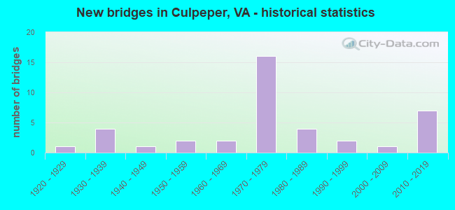
- New bridges - historical statistics
- 11920-1929
- 41930-1939
- 11940-1949
- 21950-1959
- 21960-1969
- 161970-1979
- 41980-1989
- 21990-1999
- 12000-2009
- 72010-2019

- Reconstructed bridges - Historical Statistics
- 11950-1959
- 21960-1969
- 01970-1979
- 41980-1989
- 11990-1999
- 12000-2009


- Bridge Condition - Deck
- 40.9%Good
- 54.5%Satisfactory
- 4.5%Fair

- Bridge Condition - Superstructure
- 31.8%Good
- 54.5%Satisfactory
- 13.6%Fair

- Bridge Condition - Substructure
- 36.4%Good
- 54.5%Satisfactory
- 9.1%Fair

- Bridge Condition - Channel
- 17.4%Very good
- 13.0%Good
- 43.5%Satisfactory
- 17.4%Fair
- 8.7%Poor

- Bridge Condition - Culverts
- 58.3%Good
- 33.3%Satisfactory
- 8.3%Fair
Find on map >> Show street view
Structure Number: 5563, Location: .37 Fr 522&.29 To Cul TL (Lat: 38.449931, Lng: -77.983119), Route carried "on" structure: Bypass State highway 3, Year Built: 1972, Status: Open, Structure Length: 5.61m (18.41ft), Average Daily Traffic: 10,926 (year 2020), Truck Traffic: 4%, Average Future Daily Traffic: 11,728 (year 2040), Design Load: HS 20+Mod, Features Intersected: Route 15/29 Bypass, Facility Carried by Structure: Germanna Highway
Minimum Vertical Clearance: 30+ m (98+ ft), Kilometerpoint: 115.655, Lanes on structure: 4, Lanes under structure: 4, Base Highway Network: Yes, Owner: State Highway Agency, Approaching Roadway Width: 24.7m (81.0ft), Skew: 20 degrees, Material/Design: Steel continuous, Design/Construction: Stringer/Multi-beam, Number Of Spans In Main Unit: 2, Length of Maximum Span: 28.0m (91.9ft), Curb-To-Curb Width: 19.5m (64.0ft), Out-to-Out Width: 25.6m (84.0ft)
Condition: Deck: Good, Superstructure: Good, Substructure: Good, Operating Rating: 48.1 metric tons, Method Used To Determine Operating Rating: Load and Resistance Factor (LRFR), Inventory Rating: 37.2 metric tons, Method Used To Determine Inventory Rating: Load and Resistance Factor (LRFR), Structural Evaluation: Better than present minimum criteria, Deck Geometry: Better than present minimum criteria, Underclear: Somewhat better than minimum adequacy, Approach Roadway Alignment: Equal to present desirable criteria, Designated Inspection Frequency: Every 24 months, Inspection Date: July 2021, Deck Structure Type: Concrete Cast-file-Place, Wearing Surface/Protective System: Wearing Surface: Latex Concrete
Find on map >> Show street view
Structure Number: 5567, Location: .41From 649 & 1.00 To 692 (Lat: 38.415533, Lng: -78.050681), Route carried "on" structure: US 15, Year Built: 1929, Year Reconstructed: 1958, Status: Open, Structure Length: 0.84m (2.76ft), Average Daily Traffic: 6,479 (year 2020), Truck Traffic: 5%, Average Future Daily Traffic: 8,854 (year 2040), Design Load: HS 20, Features Intersected: Cedar Run, Facility Carried by Structure: James Madison Hwy
Minimum Vertical Clearance: 30+ m (98+ ft), Kilometerpoint: 249.837, Lanes on structure: 2, Base Highway Network: Yes, Owner: State Highway Agency, Approaching Roadway Width: 6.4m (21.0ft), Material/Design: Concrete, Design/Construction: Tee Beam, Number Of Spans In Main Unit: 1, Length of Maximum Span: 7.6m (24.9ft), Curb-To-Curb Width: 11.3m (37.1ft), Out-to-Out Width: 12.2m (40.0ft)
Condition: Deck: Satisfactory, Superstructure: Satisfactory, Substructure: Satisfactory, Channel: Satisfactory, Operating Rating: 48.1 metric tons, Method Used To Determine Operating Rating: Load Factor (LF), Inventory Rating: 28.1 metric tons, Method Used To Determine Inventory Rating: Load Factor (LF), Structural Evaluation: Equal to present minimum criteria, Deck Geometry: Meets minimum limits, Waterway Adequacy: Equal to present desirable criteria, Approach Roadway Alignment: Equal to present desirable criteria, Designated Inspection Frequency: Every 24 months, Inspection Date: July 2021, Deck Structure Type: Concrete Cast-file-Place, Wearing Surface/Protective System: Wearing Surface: Bituminous
Find on map >> Show street view
Structure Number: 557, Location: .07FromSCL Culp&.10To686 (Lat: 38.445669, Lng: -78.008831), Route carried "on" structure: Business US 15, Year Built: 1971, Status: Open, Structure Length: 4.94m (16.21ft), Average Daily Traffic: 6,982 (year 2020), Truck Traffic: 2%, Average Future Daily Traffic: 7,680 (year 2040), Design Load: HS 20+Mod, Features Intersected: Route 29 Bypass, Facility Carried by Structure: James Madison Hwy.
Minimum Vertical Clearance: 30+ m (98+ ft), Kilometerpoint: 254.898, Lanes on structure: 4, Lanes under structure: 4, Base Highway Network: Yes, Owner: State Highway Agency, Approaching Roadway Width: 15.5m (50.9ft), Skew: 22 degrees, Material/Design: Steel, Design/Construction: Stringer/Multi-beam, Number Of Spans In Main Unit: 2, Length of Maximum Span: 24.7m (81.0ft), Curb or Sidewalk Widths: Left: 0.2m (0.7ft), Right: 0.2m (0.7ft), Curb-To-Curb Width: 18.5m (60.7ft), Out-to-Out Width: 24.6m (80.7ft)
Condition: Deck: Satisfactory, Superstructure: Satisfactory, Substructure: Satisfactory, Operating Rating: 49.0 metric tons, Method Used To Determine Operating Rating: Load and Resistance Factor (LRFR), Inventory Rating: 38.1 metric tons, Method Used To Determine Inventory Rating: Load and Resistance Factor (LRFR), Structural Evaluation: Equal to present minimum criteria, Deck Geometry: Equal to present minimum criteria, Underclear: Equal to present minimum criteria, Approach Roadway Alignment: Equal to present desirable criteria, Designated Inspection Frequency: Every 24 months, Inspection Date: May 2020, Deck Structure Type: Concrete Cast-file-Place, Wearing Surface/Protective System: Wearing Surface: Epoxy Overlay
Find on map >> Show street view
Structure Number: 5572, Location: .70 From 342 & .35 To 665 (Lat: 38.489100, Lng: -77.937389), Route carried "on" structure: Business US 15, Year Built: 1972, Year Reconstructed: 1993, Status: Open, Structure Length: 6.92m (22.70ft), Average Daily Traffic: 10,723 (year 2020), Truck Traffic: 4%, Average Future Daily Traffic: 14,652 (year 2040), Design Load: HS 20+Mod, Features Intersected: Route 15/29 Bypass
Minimum Vertical Clearance: 30+ m (98+ ft), Kilometerpoint: 9.203, Lanes on structure: 4, Lanes under structure: 4, Owner: State Highway Agency, Approaching Roadway Width: 15.2m (49.9ft), Skew: 24 degrees, Material/Design: Steel, Design/Construction: Stringer/Multi-beam, Number Of Spans In Main Unit: 2, Length of Maximum Span: 34.7m (113.8ft), Curb-To-Curb Width: 19.5m (64.0ft), Out-to-Out Width: 25.6m (84.0ft)
Condition: Deck: Satisfactory, Superstructure: Satisfactory, Substructure: Satisfactory, Operating Rating: 69.9 metric tons, Method Used To Determine Operating Rating: Load and Resistance Factor (LRFR), Inventory Rating: 54.4 metric tons, Method Used To Determine Inventory Rating: Load and Resistance Factor (LRFR), Structural Evaluation: Equal to present minimum criteria, Deck Geometry: Better than present minimum criteria, Underclear: Somewhat better than minimum adequacy, Approach Roadway Alignment: Equal to present desirable criteria, Designated Inspection Frequency: Every 24 months, Inspection Date: July 2021, Deck Structure Type: Concrete Cast-file-Place, Wearing Surface/Protective System: Wearing Surface: Latex Concrete
Find on map >> Show street view
Structure Number: 5577, Location: 1.04 From663&1.61To15Bus (Lat: 38.500553, Lng: -77.912931), Route carried "on" structure: US 15, Year Built: 1975, Status: Open, Structure Length: 0.79m (2.59ft), Average Daily Traffic: 47,651 (year 2020), Truck Traffic: 9%, Average Future Daily Traffic: 57,072 (year 2040), Design Load: HS 20, Features Intersected: Branch Jonas Run, Facility Carried by Structure: James Madison Hwy
Minimum Vertical Clearance: 30+ m (98+ ft), Kilometerpoint: 265.865, Lanes on structure: 4, Base Highway Network: Yes, Owner: State Highway Agency, Approaching Roadway Width: 14.6m (47.9ft), Skew: 2 degrees, Material/Design: Concrete, Design/Construction: Culvert, Number Of Spans In Main Unit: 3, Length of Maximum Span: 2.4m (7.9ft)
Condition: Channel: Satisfactory, Culverts: Satisfactory, Operating Rating: 89.8 metric tons, Method Used To Determine Operating Rating: Load Factor (LF), Inventory Rating: 89.8 metric tons, Method Used To Determine Inventory Rating: Load Factor (LF), Structural Evaluation: Equal to present minimum criteria, Waterway Adequacy: Equal to present desirable criteria, Approach Roadway Alignment: Equal to present desirable criteria, Designated Inspection Frequency: Every 24 months, Inspection Date: November 2020
Find on map >> Show street view
Structure Number: 5581, Location: .75 From 15 & .73 To 3 (Lat: 38.445250, Lng: -77.995019), Route carried "on" structure: Bypass US 15, Year Built: 1971, Status: Open, Structure Length: 6.52m (21.39ft), Average Daily Traffic: 10,164 (year 2020), Truck Traffic: 6%, Average Future Daily Traffic: 14,231 (year 2040), Design Load: HS 20+Mod, Features Intersected: Norfolk Southern Railway
Minimum Vertical Clearance: 30+ m (98+ ft), Kilometerpoint: 291.020, Lanes on structure: 2, Base Highway Network: Yes, Owner: State Highway Agency, Approaching Roadway Width: 7.3m (24.0ft), Material/Design: Steel continuous, Design/Construction: Stringer/Multi-beam, Number Of Spans In Main Unit: 3, Length of Maximum Span: 25.9m (85.0ft), Curb-To-Curb Width: 11.6m (38.1ft), Out-to-Out Width: 12.8m (42.0ft)
Condition: Deck: Satisfactory, Superstructure: Satisfactory, Substructure: Satisfactory, Operating Rating: 49.9 metric tons, Method Used To Determine Operating Rating: Load and Resistance Factor (LRFR), Inventory Rating: 38.1 metric tons, Method Used To Determine Inventory Rating: Load and Resistance Factor (LRFR), Structural Evaluation: Equal to present minimum criteria, Deck Geometry: Better than present minimum criteria, Underclear: Superior to present desirable criteria, Approach Roadway Alignment: Equal to present desirable criteria, Designated Inspection Frequency: Every 24 months, Inspection Date: March 2021, Deck Structure Type: Concrete Cast-file-Place, Wearing Surface/Protective System: Wearing Surface: Epoxy Overlay
Find on map >> Show street view
Structure Number: 5582, Location: .75 FR. 15 & .73 TO 3 (Lat: 38.445075, Lng: -77.995003), Route carried "on" structure: Bypass US 15, Year Built: 1971, Status: Open, Structure Length: 6.58m (21.59ft), Average Daily Traffic: 10,164 (year 2020), Truck Traffic: 6%, Average Future Daily Traffic: 14,231 (year 2040), Design Load: HS 20+Mod, Features Intersected: Norfolk Southern Railway, Facility Carried by Structure: NBL James Mad Hwy.
Minimum Vertical Clearance: 30+ m (98+ ft), Kilometerpoint: 291.020, Lanes on structure: 2, Base Highway Network: Yes, Owner: State Highway Agency, Approaching Roadway Width: 7.3m (24.0ft), Material/Design: Steel continuous, Design/Construction: Stringer/Multi-beam, Number Of Spans In Main Unit: 3, Length of Maximum Span: 25.9m (85.0ft), Curb-To-Curb Width: 11.6m (38.1ft), Out-to-Out Width: 12.8m (42.0ft)
Condition: Deck: Good, Superstructure: Satisfactory, Substructure: Good, Operating Rating: 47.2 metric tons, Method Used To Determine Operating Rating: Load and Resistance Factor (LRFR), Inventory Rating: 36.3 metric tons, Method Used To Determine Inventory Rating: Load and Resistance Factor (LRFR), Structural Evaluation: Equal to present minimum criteria, Deck Geometry: Better than present minimum criteria, Underclear: Superior to present desirable criteria, Approach Roadway Alignment: Equal to present desirable criteria, Designated Inspection Frequency: Every 24 months, Inspection Date: October 2020, Deck Structure Type: Concrete Cast-file-Place, Wearing Surface/Protective System: Wearing Surface: Epoxy Overlay
Find on map >> Show street view
Structure Number: 5585, Location: 1.22 From 3 &1.15 To 666 (Lat: 38.461414, Lng: -77.966861), Route carried "on" structure: US 15, Year Built: 1971, Status: Open, Structure Length: 1.28m (4.20ft), Average Daily Traffic: 10,716 (year 2020), Truck Traffic: 6%, Average Future Daily Traffic: 15,002 (year 2040), Design Load: HS 20, Features Intersected: Mountain Run
Minimum Vertical Clearance: 30+ m (98+ ft), Kilometerpoint: 294.109, Lanes on structure: 2, Base Highway Network: Yes, Owner: State Highway Agency, Approaching Roadway Width: 7.3m (24.0ft), Material/Design: Concrete, Design/Construction: Culvert, Number Of Spans In Main Unit: 4, Length of Maximum Span: 3.0m (9.8ft)
Condition: Channel: Poor, Culverts: Satisfactory, Operating Rating: 89.8 metric tons, Method Used To Determine Operating Rating: Load Factor (LF), Inventory Rating: 59.9 metric tons, Method Used To Determine Inventory Rating: Load Factor (LF), Structural Evaluation: Equal to present minimum criteria, Waterway Adequacy: Equal to present desirable criteria, Approach Roadway Alignment: Equal to present desirable criteria, Designated Inspection Frequency: Every 24 months, Inspection Date: September 2021
Find on map >> Show street view
Structure Number: 5589, Location: 1.22 From 3 & 1.15 To 666 (Lat: 38.461000, Lng: -77.966281), Route carried "on" structure: US 15, Year Built: 1971, Status: Open, Structure Length: 1.28m (4.20ft), Average Daily Traffic: 10,716 (year 2020), Truck Traffic: 6%, Average Future Daily Traffic: 15,002 (year 2040), Design Load: HS 20, Features Intersected: Mountain Run
Minimum Vertical Clearance: 30+ m (98+ ft), Kilometerpoint: 294.109, Lanes on structure: 2, Base Highway Network: Yes, Owner: State Highway Agency, Approaching Roadway Width: 7.3m (24.0ft), Material/Design: Concrete, Design/Construction: Culvert, Number Of Spans In Main Unit: 4, Length of Maximum Span: 3.0m (9.8ft)
Condition: Channel: Poor, Culverts: Satisfactory, Operating Rating: 89.8 metric tons, Method Used To Determine Operating Rating: Load Factor (LF), Inventory Rating: 59.9 metric tons, Method Used To Determine Inventory Rating: Load Factor (LF), Structural Evaluation: Equal to present minimum criteria, Waterway Adequacy: Equal to present desirable criteria, Approach Roadway Alignment: Equal to present desirable criteria, Designated Inspection Frequency: Every 24 months, Inspection Date: September 2021
Find on map >> Show street view
Structure Number: 5597, Location: .90 From 630 & .35 To 631 (Lat: 38.544661, Lng: -77.978956), Route carried "on" structure: State highway 229, Year Built: 1936, Year Reconstructed: 1991, Status: Open, Structure Length: 2.64m (8.66ft), Average Daily Traffic: 6,888 (year 2020), Truck Traffic: 2%, Average Future Daily Traffic: 9,194 (year 2040), Design Load: HS 20, Features Intersected: Muddy Run, Facility Carried by Structure: Rixeyville Road
Minimum Vertical Clearance: 30+ m (98+ ft), Kilometerpoint: 7.482, Lanes on structure: 2, Base Highway Network: Yes, Owner: State Highway Agency, Approaching Roadway Width: 7.3m (24.0ft), Material/Design: Steel, Design/Construction: Stringer/Multi-beam, Number Of Spans In Main Unit: 1, Length of Maximum Span: 25.8m (84.6ft), Curb-To-Curb Width: 9.3m (30.5ft), Out-to-Out Width: 10.3m (33.8ft)
Condition: Deck: Satisfactory, Superstructure: Satisfactory, Substructure: Satisfactory, Channel: Satisfactory, Operating Rating: 71.7 metric tons, Method Used To Determine Operating Rating: Load and Resistance Factor (LRFR), Inventory Rating: 55.3 metric tons, Method Used To Determine Inventory Rating: Load and Resistance Factor (LRFR), Structural Evaluation: Equal to present minimum criteria, Deck Geometry: High priority of corrective action, Waterway Adequacy: Equal to present desirable criteria, Approach Roadway Alignment: Equal to present desirable criteria, Designated Inspection Frequency: Every 24 months, Inspection Date: August 2021, Deck Structure Type: Concrete Cast-file-Place, Wearing Surface/Protective System: Deck Protection: Epoxy Coated Reinforcing
Find on map >> Show street view
Structure Number: 5644, Location: .15 From 711 & .25 To 631 (Lat: 38.546092, Lng: -77.972542), Route carried "on" structure: County highway 630, Year Built: 1987, Status: Posted for load, Structure Length: 1.40m (4.59ft), Average Daily Traffic: 306 (year 2014), Average Future Daily Traffic: 465 (year 2040), Design Load: HS 20, Features Intersected: Muddy Run, Facility Carried by Structure: Jamesons Mill Road
Minimum Vertical Clearance: 30+ m (98+ ft), Kilometerpoint: 1.850, Lanes on structure: 2, Owner: State Highway Agency, Approaching Roadway Width: 6.1m (20.0ft), Material/Design: Steel, Design/Construction: Stringer/Multi-beam, Number Of Spans In Main Unit: 1, Length of Maximum Span: 14.0m (45.9ft), Curb-To-Curb Width: 6.7m (22.0ft), Out-to-Out Width: 7.3m (24.0ft)
Condition: Deck: Good, Superstructure: Fair, Substructure: Satisfactory, Channel: Fair, Operating Rating: 36.3 metric tons, Method Used To Determine Operating Rating: Load Factor (LF), Inventory Rating: 20.9 metric tons, Method Used To Determine Inventory Rating: Load Factor (LF), Structural Evaluation: Somewhat better than minimum adequacy, Deck Geometry: Meets minimum limits, Waterway Adequacy: Better than present minimum criteria, Approach Roadway Alignment: Equal to present minimum criteria, Designated Inspection Frequency: Every 24 months, Inspection Date: June 2020, Deck Structure Type: Wood or Timber, Wearing Surface/Protective System: Wearing Surface: Bituminous
Find on map >> Show street view
Structure Number: 5647, Location: 1.40 From 766&1.50 To 633 (Lat: 38.533392, Lng: -77.999797), Route carried "on" structure: County highway 632, Year Built: 1970, Year Reconstructed: 2008, Status: Open, Structure Length: 0.67m (2.20ft), Average Daily Traffic: 780 (year 2020), Truck Traffic: 2%, Average Future Daily Traffic: 1,092 (year 2040), Design Load: HS 20, Features Intersected: Branch of Muddy Run, Facility Carried by Structure: Dutch Hollow Road
Minimum Vertical Clearance: 30+ m (98+ ft), Kilometerpoint: 2.446, Lanes on structure: 2, Owner: State Highway Agency, Approaching Roadway Width: 6.1m (20.0ft), Material/Design: Steel, Design/Construction: Culvert, Number Of Spans In Main Unit: 2, Length of Maximum Span: 3.0m (9.8ft)
Condition: Channel: Fair, Culverts: Good, Operating Rating: 44.5 metric tons, Method Used To Determine Operating Rating: Field evaluation and documented engineering judgment, Inventory Rating: 32.7 metric tons, Method Used To Determine Inventory Rating: Field evaluation and documented engineering judgment, Structural Evaluation: Better than present minimum criteria, Waterway Adequacy: Equal to present minimum criteria, Approach Roadway Alignment: Better than present minimum criteria, Designated Inspection Frequency: Every 24 months, Inspection Date: Febuary 2021
Find on map >> Show street view
Structure Number: 5658, Location: 1.60 From 522 &.80 To 719 (Lat: 38.478006, Lng: -78.048764), Route carried "on" structure: County highway 641, Year Built: 1982, Status: Open, Structure Length: 0.91m (2.99ft), Average Daily Traffic: 1,133 (year 2014), Average Future Daily Traffic: 1,484 (year 2040), Design Load: HS 20, Features Intersected: Mountain Run, Facility Carried by Structure: Gibson Mill Road
Minimum Vertical Clearance: 30+ m (98+ ft), Kilometerpoint: 3.701, Lanes on structure: 2, Owner: State Highway Agency, Approaching Roadway Width: 6.7m (22.0ft), Skew: 1 degrees, Material/Design: Concrete, Design/Construction: Slab, Number Of Spans In Main Unit: 1, Length of Maximum Span: 8.5m (27.9ft), Curb-To-Curb Width: 8.8m (28.9ft), Out-to-Out Width: 10.1m (33.1ft)
Condition: Deck: Satisfactory, Superstructure: Satisfactory, Substructure: Satisfactory, Channel: Satisfactory, Operating Rating: 59.0 metric tons, Method Used To Determine Operating Rating: Load and Resistance Factor (LRFR), Inventory Rating: 45.4 metric tons, Method Used To Determine Inventory Rating: Load and Resistance Factor (LRFR), Structural Evaluation: Equal to present minimum criteria, Deck Geometry: Somewhat better than minimum adequacy, Waterway Adequacy: Equal to present minimum criteria, Approach Roadway Alignment: High priority of corrective action, Designated Inspection Frequency: Every 24 months, Inspection Date: Febuary 2021, Deck Structure Type: Concrete Precast Panels, Wearing Surface/Protective System: Wearing Surface: Bituminous, Membrane: Epoxy
Find on map >> Show street view
Structure Number: 5673, Location: .45 From 617& 1.25 To 656 (Lat: 38.411839, Lng: -77.983478), Route carried "on" structure: County highway 652, Year Built: 1965, Status: Open, Structure Length: 0.82m (2.69ft), Average Daily Traffic: 184 (year 2014), Average Future Daily Traffic: 208 (year 2040), Design Load: HS 20, Features Intersected: Summerduck Run, Facility Carried by Structure: Cedar Grove Road
Minimum Vertical Clearance: 30+ m (98+ ft), Kilometerpoint: 8.656, Lanes on structure: 2, Owner: State Highway Agency, Approaching Roadway Width: 4.9m (16.1ft), Material/Design: Concrete, Design/Construction: Slab, Number Of Spans In Main Unit: 1, Length of Maximum Span: 7.6m (24.9ft), Curb-To-Curb Width: 6.1m (20.0ft), Out-to-Out Width: 6.7m (22.0ft)
Condition: Deck: Satisfactory, Superstructure: Satisfactory, Substructure: Satisfactory, Channel: Satisfactory, Operating Rating: 62.6 metric tons, Method Used To Determine Operating Rating: Load Factor (LF), Inventory Rating: 36.3 metric tons, Method Used To Determine Inventory Rating: Load Factor (LF), Structural Evaluation: Equal to present minimum criteria, Deck Geometry: Meets minimum limits, Waterway Adequacy: Equal to present minimum criteria, Approach Roadway Alignment: Equal to present desirable criteria, Designated Inspection Frequency: Every 24 months, Inspection Date: December 2021, Deck Structure Type: Concrete Cast-file-Place
Find on map >> Show street view
Structure Number: 5675, Location: 1.40 From661 & .60 To662 (Lat: 38.416258, Lng: -77.939953), Route carried "on" structure: County highway 658, Year Built: 1971, Status: Open, Structure Length: 0.91m (2.99ft), Average Daily Traffic: 199 (year 2014), Average Future Daily Traffic: 236 (year 2040), Design Load: HS 20, Features Intersected: Potato Run, Facility Carried by Structure: Mt. Pony Road
Minimum Vertical Clearance: 30+ m (98+ ft), Kilometerpoint: 5.173, Lanes on structure: 2, Owner: State Highway Agency, Approaching Roadway Width: 6.1m (20.0ft), Skew: 2 degrees, Material/Design: Steel, Design/Construction: Culvert, Number Of Spans In Main Unit: 3, Length of Maximum Span: 2.7m (8.9ft)
Condition: Channel: Fair, Culverts: Fair, Operating Rating: 44.5 metric tons, Method Used To Determine Operating Rating: Field evaluation and documented engineering judgment, Inventory Rating: 32.7 metric tons, Method Used To Determine Inventory Rating: Field evaluation and documented engineering judgment, Structural Evaluation: Somewhat better than minimum adequacy, Waterway Adequacy: Equal to present minimum criteria, Approach Roadway Alignment: Equal to present desirable criteria, Designated Inspection Frequency: Every 24 months, Inspection Date: December 2020
Find on map >> Show street view
Structure Number: 568, Location: .3 FR 15&29Bus &.4 TO 699 (Lat: 38.477361, Lng: -77.976600), Route carried "on" structure: County highway 667, Year Built: 1965, Status: Open, Structure Length: 4.45m (14.60ft), Average Daily Traffic: 1,964 (year 2014), Average Future Daily Traffic: 2,985 (year 2040), Design Load: HS 20+Mod, Features Intersected: Norfolk Southern RR, Facility Carried by Structure: Nalles Mill Road
Minimum Vertical Clearance: 30+ m (98+ ft), Kilometerpoint: 1.545, Lanes on structure: 2, Owner: State Highway Agency, Approaching Roadway Width: 6.1m (20.0ft), Material/Design: Prestressed concrete, Design/Construction: Slab, Number Of Spans In Main Unit: 3, Length of Maximum Span: 16.5m (54.1ft), Curb or Sidewalk Widths: Left: 0.5m (1.6ft), Right: 0.5m (1.6ft), Curb-To-Curb Width: 7.4m (24.3ft), Out-to-Out Width: 8.9m (29.2ft)
Condition: Deck: Satisfactory, Superstructure: Satisfactory, Substructure: Satisfactory, Operating Rating: 66.2 metric tons, Method Used To Determine Operating Rating: Load and Resistance Factor (LRFR), Inventory Rating: 50.8 metric tons, Method Used To Determine Inventory Rating: Load and Resistance Factor (LRFR), Structural Evaluation: Equal to present minimum criteria, Deck Geometry: Meets minimum limits, Underclear: Better than present minimum criteria, Approach Roadway Alignment: Equal to present desirable criteria, Designated Inspection Frequency: Every 24 months, Inspection Date: April 2020, Deck Structure Type: Other, Wearing Surface/Protective System: Wearing Surface: Bituminous, Membrane: Epoxy
Find on map >> Show street view
Structure Number: 5687, Location: .05 From 703 & .25 To 665 (Lat: 38.488144, Lng: -77.937844), Route carried "on" structure: County highway 684, Year Built: 1972, Status: Open, Structure Length: 6.15m (20.18ft), Average Daily Traffic: 666 (year 2014), Average Future Daily Traffic: 765 (year 2040), Design Load: HS 20+Mod, Features Intersected: Route 15/29 Bypass, Facility Carried by Structure: Bel Pre Road
Minimum Vertical Clearance: 30+ m (98+ ft), Kilometerpoint: 0.080, Lanes on structure: 2, Lanes under structure: 4, Owner: State Highway Agency, Approaching Roadway Width: 6.1m (20.0ft), Skew: 3 degrees, Material/Design: Steel, Design/Construction: Stringer/Multi-beam, Number Of Spans In Main Unit: 2, Length of Maximum Span: 31.2m (102.4ft), Curb or Sidewalk Widths: Left: 0.2m (0.7ft), Right: 0.2m (0.7ft), Curb-To-Curb Width: 8.7m (28.5ft), Out-to-Out Width: 10.0m (32.8ft)
Condition: Deck: Good, Superstructure: Satisfactory, Substructure: Satisfactory, Operating Rating: 65.3 metric tons, Method Used To Determine Operating Rating: Load and Resistance Factor (LRFR), Inventory Rating: 50.8 metric tons, Method Used To Determine Inventory Rating: Load and Resistance Factor (LRFR), Structural Evaluation: Equal to present minimum criteria, Deck Geometry: Somewhat better than minimum adequacy, Underclear: High priority of corrective action, Approach Roadway Alignment: Equal to present desirable criteria, Designated Inspection Frequency: Every 24 months, Inspection Date: March 2021, Deck Structure Type: Concrete Cast-file-Place, Wearing Surface/Protective System: Wearing Surface: Epoxy Overlay
Find on map >> Show street view
Structure Number: 5693, Location: .71 Fr 720 & .85 To 522 (Lat: 38.444789, Lng: -77.994947), Route carried "on" structure: County highway 686, Year Built: 1973, Status: Open, Structure Length: 4.82m (15.81ft), Average Daily Traffic: 1,693 (year 2020), Truck Traffic: 3%, Average Future Daily Traffic: 2,224 (year 2040), Design Load: HS 20, Features Intersected: Norfolk Southern Railway, Facility Carried by Structure: Lovers Lane
Minimum Vertical Clearance: 30+ m (98+ ft), Kilometerpoint: 1.464, Lanes on structure: 2, Owner: State Highway Agency, Approaching Roadway Width: 7.3m (24.0ft), Material/Design: Steel, Design/Construction: Stringer/Multi-beam, Number Of Spans In Main Unit: 3, Length of Maximum Span: 17.1m (56.1ft), Curb-To-Curb Width: 9.8m (32.2ft), Out-to-Out Width: 11.0m (36.1ft)
Condition: Deck: Good, Superstructure: Fair, Substructure: Fair, Operating Rating: 67.1 metric tons, Method Used To Determine Operating Rating: Load and Resistance Factor (LRFR), Inventory Rating: 51.7 metric tons, Method Used To Determine Inventory Rating: Load and Resistance Factor (LRFR), Structural Evaluation: Somewhat better than minimum adequacy, Deck Geometry: Somewhat better than minimum adequacy, Underclear: Equal to present minimum criteria, Approach Roadway Alignment: Equal to present desirable criteria, Designated Inspection Frequency: Every 24 months, Inspection Date: January 2022, Deck Structure Type: Concrete Cast-file-Place, Wearing Surface/Protective System: Wearing Surface: Epoxy Overlay
Find on map >> Show street view
Structure Number: 5697, Location: .05 From667 & .65 To 699 (Lat: 38.472114, Lng: -77.971897), Route carried "on" structure: County highway 799, Year Built: 1988, Status: Open, Structure Length: 2.80m (9.19ft), Average Daily Traffic: 4,958 (year 2014), Average Future Daily Traffic: 5,603 (year 2040), Design Load: HS 20, Features Intersected: Mountain Run, Facility Carried by Structure: Keyser Road
Minimum Vertical Clearance: 30+ m (98+ ft), Kilometerpoint: 1.448, Lanes on structure: 2, Owner: State Highway Agency, Approaching Roadway Width: 8.5m (27.9ft), Skew: 2 degrees, Material/Design: Steel, Design/Construction: Stringer/Multi-beam, Number Of Spans In Main Unit: 1, Length of Maximum Span: 27.4m (89.9ft), Curb-To-Curb Width: 8.7m (28.5ft), Out-to-Out Width: 9.7m (31.8ft)
Condition: Deck: Satisfactory, Superstructure: Good, Substructure: Good, Channel: Satisfactory, Operating Rating: 69.9 metric tons, Method Used To Determine Operating Rating: Load and Resistance Factor (LRFR), Inventory Rating: 53.5 metric tons, Method Used To Determine Inventory Rating: Load and Resistance Factor (LRFR), Structural Evaluation: Better than present minimum criteria, Deck Geometry: Meets minimum limits, Waterway Adequacy: Better than present minimum criteria, Approach Roadway Alignment: Equal to present desirable criteria, Designated Inspection Frequency: Every 24 months, Inspection Date: July 2020, Deck Structure Type: Concrete Cast-file-Place, Wearing Surface/Protective System: Deck Protection: Epoxy Coated Reinforcing
Find on map >> Show street view
Structure Number: 5706, Location: 1.07 From 342 &.80 To 663 (Lat: 38.497694, Lng: -77.907322), Route carried "on" structure: County highway 762, Year Built: 1932, Status: Open, Structure Length: 0.99m (3.25ft), Average Daily Traffic: 2,135 (year 2020), Truck Traffic: 8%, Average Future Daily Traffic: 2,348 (year 2040), Design Load: HS 20, Features Intersected: Jonas Run, Facility Carried by Structure: Old Brandy Road
Minimum Vertical Clearance: 30+ m (98+ ft), Kilometerpoint: 2.076, Lanes on structure: 2, Owner: State Highway Agency, Approaching Roadway Width: 6.1m (20.0ft), Material/Design: Concrete, Design/Construction: Tee Beam, Number Of Spans In Main Unit: 1, Length of Maximum Span: 9.1m (29.9ft), Curb-To-Curb Width: 6.7m (22.0ft), Out-to-Out Width: 7.9m (25.9ft)
Condition: Deck: Fair, Superstructure: Fair, Substructure: Fair, Channel: Satisfactory, Operating Rating: 40.8 metric tons, Method Used To Determine Operating Rating: Load Factor (LF), Inventory Rating: 24.5 metric tons, Method Used To Determine Inventory Rating: Load Factor (LF), Structural Evaluation: Somewhat better than minimum adequacy, Deck Geometry: High priority of replacement, Waterway Adequacy: Equal to present desirable criteria, Approach Roadway Alignment: Equal to present desirable criteria, Length Of Structure Improvement: 1.01m (3.31ft), Designated Inspection Frequency: Every 24 months, Inspection Date: October 2020, Bridge Improvement Cost: $102,000, Roadway Improvement Cost: $8,000, Total Project Cost: $115,000, Deck Structure Type: Concrete Cast-file-Place, Wearing Surface/Protective System: Wearing Surface: Bituminous
Find on map >> Show street view
Structure Number: 2257, Location: .01 FR WINE ST& .4 TO 697 (Lat: 38.477772, Lng: -77.987714), Route carried "on" structure: City street , Year Built: 1983, Status: Open, Structure Length: 1.92m (6.30ft), Average Daily Traffic: 3,241 (year 2020), Truck Traffic: 1%, Average Future Daily Traffic: 4,537 (year 2040), Design Load: HS 20, Features Intersected: MOUNTAIN RUN, Facility Carried by Structure: OLD BRANDY ROAD
Minimum Vertical Clearance: 30+ m (98+ ft), Kilometerpoint: 0.000, Lanes on structure: 2, Owner: Town or Township Highway Agency, Approaching Roadway Width: 11.9m (39.0ft), Skew: 4 degrees, Material/Design: Concrete, Design/Construction: Culvert, Number Of Spans In Main Unit: 4, Length of Maximum Span: 4.6m (15.1ft)
Condition: Channel: Satisfactory, Culverts: Good, Operating Rating: 44.5 metric tons, Method Used To Determine Operating Rating: Load Factor (LF), Inventory Rating: 32.7 metric tons, Method Used To Determine Inventory Rating: Load Factor (LF), Structural Evaluation: Better than present minimum criteria, Waterway Adequacy: Equal to present desirable criteria, Approach Roadway Alignment: Equal to present desirable criteria, Designated Inspection Frequency: Every 24 months, Inspection Date: November 2021
Find on map >> Show street view
Structure Number: 22571, Location: 1.20-522&.42TO15/29 (Lat: 38.459394, Lng: -77.991997), Route carried "on" structure: US 3, Year Built: 1950, Year Reconstructed: 1986, Status: Open, Structure Length: 3.22m (10.56ft), Average Daily Traffic: 7,935 (year 2020), Truck Traffic: 4%, Average Future Daily Traffic: 8,910 (year 2040), Design Load: HS 20+Mod, Features Intersected: NS RAILWAY
Minimum Vertical Clearance: 30+ m (98+ ft), Kilometerpoint: 22.220, Lanes on structure: 2, Base Highway Network: Yes, Owner: Town or Township Highway Agency, Approaching Roadway Width: 8.2m (26.9ft), Skew: 4 degrees, Material/Design: Steel, Design/Construction: Stringer/Multi-beam, Number Of Spans In Main Unit: 3, Length of Maximum Span: 13.0m (42.7ft), Curb or Sidewalk Widths: Left: 1.5m (4.9ft), Right: 0.0m, Curb-To-Curb Width: 8.5m (27.9ft), Out-to-Out Width: 10.9m (35.8ft)
Condition: Deck: Satisfactory, Superstructure: Satisfactory, Substructure: Satisfactory, Operating Rating: 81.9 metric tons, Method Used To Determine Operating Rating: Load Factor (LF), Inventory Rating: 49.5 metric tons, Method Used To Determine Inventory Rating: Load Factor (LF), Structural Evaluation: Equal to present minimum criteria, Deck Geometry: High priority of replacement, Underclear: Somewhat better than minimum adequacy, Approach Roadway Alignment: Equal to present desirable criteria, Length Of Structure Improvement: 3.99m (13.09ft), Designated Inspection Frequency: Every 24 months, Inspection Date: November 2020, Bridge Improvement Cost: $150,000, Roadway Improvement Cost: $60,000, Total Project Cost: $300,000, Deck Structure Type: Concrete Cast-file-Place, Wearing Surface/Protective System: Deck Protection: Epoxy Coated Reinforcing
Find on map >> Show street view
Structure Number: 22572, Location: 0116522 004615 (Lat: 38.459036, Lng: -77.991506), Route carried "on" structure: US 3, Year Built: 1950, Year Reconstructed: 1986, Status: Open, Structure Length: 3.96m (12.99ft), Average Daily Traffic: 7,935 (year 2020), Truck Traffic: 4%, Average Future Daily Traffic: 8,910 (year 2040), Design Load: HS 20+Mod, Features Intersected: NS RAILWAY
Minimum Vertical Clearance: 30+ m (98+ ft), Kilometerpoint: 22.156, Lanes on structure: 2, Base Highway Network: Yes, Owner: Town or Township Highway Agency, Approaching Roadway Width: 8.2m (26.9ft), Skew: 3 degrees, Material/Design: Steel, Design/Construction: Stringer/Multi-beam, Number Of Spans In Main Unit: 3, Length of Maximum Span: 13.0m (42.7ft), Curb or Sidewalk Widths: Left: 1.5m (4.9ft), Right: 0.0m, Curb-To-Curb Width: 8.5m (27.9ft), Out-to-Out Width: 10.9m (35.8ft)
Condition: Deck: Satisfactory, Superstructure: Satisfactory, Substructure: Good, Operating Rating: 82.8 metric tons, Method Used To Determine Operating Rating: Load Factor (LF), Inventory Rating: 49.5 metric tons, Method Used To Determine Inventory Rating: Load Factor (LF), Structural Evaluation: Equal to present minimum criteria, Deck Geometry: High priority of replacement, Underclear: Equal to present minimum criteria, Approach Roadway Alignment: Equal to present desirable criteria, Length Of Structure Improvement: 3.96m (12.99ft), Designated Inspection Frequency: Every 24 months, Inspection Date: November 2020, Bridge Improvement Cost: $150,000, Roadway Improvement Cost: $60,000, Total Project Cost: $300,000, Deck Structure Type: Concrete Cast-file-Place, Wearing Surface/Protective System: Deck Protection: Epoxy Coated Reinforcing
Find on map >> Show street view
Structure Number: 22573, Location: .5 RT 522; 1.8 RT 15 & 29 (Lat: 38.480794, Lng: -77.987025), Route carried "on" structure: US 15, Year Built: 1932, Year Reconstructed: 1972, Status: Open, Structure Length: 0.88m (2.89ft), Average Daily Traffic: 20,499 (year 2020), Truck Traffic: 2%, Average Future Daily Traffic: 28,699 (year 2040), Design Load: HS 20, Features Intersected: HIDENS BRANCH
Minimum Vertical Clearance: 30+ m (98+ ft), Kilometerpoint: 16.460, Lanes on structure: 4, Base Highway Network: Yes, Owner: Town or Township Highway Agency, Approaching Roadway Width: 27.4m (89.9ft), Material/Design: Concrete, Design/Construction: Culvert, Number Of Spans In Main Unit: 4, Length of Maximum Span: 1.8m (5.9ft)
Condition: Channel: Satisfactory, Culverts: Good, Operating Rating: 44.5 metric tons, Method Used To Determine Operating Rating: Load Factor (LF), Inventory Rating: 32.7 metric tons, Method Used To Determine Inventory Rating: Load Factor (LF), Structural Evaluation: Better than present minimum criteria, Waterway Adequacy: Equal to present desirable criteria, Approach Roadway Alignment: Equal to present desirable criteria, Designated Inspection Frequency: Every 24 months, Inspection Date: November 2021
Find on map >> Show street view
Structure Number: 22574, Location: 0015522 0006229 (Lat: 38.478375, Lng: -77.994217), Route carried "on" structure: US 15, Year Built: 1932, Year Reconstructed: 1967, Status: Open, Structure Length: 2.96m (9.71ft), Average Daily Traffic: 15,494 (year 2020), Truck Traffic: 3%, Average Future Daily Traffic: 21,692 (year 2040), Design Load: H 20, Features Intersected: MOUNTAIN_RUN
Minimum Vertical Clearance: 30+ m (98+ ft), Kilometerpoint: 17.200, Lanes on structure: 4, Base Highway Network: Yes, Owner: Town or Township Highway Agency, Approaching Roadway Width: 15.8m (51.8ft), Material/Design: Concrete, Design/Construction: Tee Beam, Number Of Spans In Main Unit: 3, Length of Maximum Span: 10.1m (33.1ft), Curb or Sidewalk Widths: Left: 1.5m (4.9ft), Right: 0.0m, Curb-To-Curb Width: 15.8m (51.8ft), Out-to-Out Width: 18.0m (59.1ft)
Condition: Deck: Good, Superstructure: Good, Substructure: Satisfactory, Channel: Very good, Operating Rating: 49.5 metric tons, Method Used To Determine Operating Rating: Load Factor (LF), Inventory Rating: 29.7 metric tons, Method Used To Determine Inventory Rating: Load Factor (LF), Structural Evaluation: Equal to present minimum criteria, Deck Geometry: Meets minimum limits, Waterway Adequacy: Equal to present minimum criteria, Approach Roadway Alignment: Better than present minimum criteria, Designated Inspection Frequency: Every 24 months, Inspection Date: November 2020, Deck Structure Type: Concrete Cast-file-Place, Wearing Surface/Protective System: Wearing Surface: Latex Concrete
Find on map >> Show street view
Structure Number: 23528, Location: 0130CULPE CO 002215 & 29 (Lat: 38.477472, Lng: -77.998553), Route carried "on" structure: US 522, Year Built: 1992, Status: Open, Structure Length: 4.33m (14.21ft), Average Daily Traffic: 9,139 (year 2020), Truck Traffic: 2%, Average Future Daily Traffic: 12,795 (year 2040), Design Load: HS 20+Mod, Features Intersected: MOUNTAIN RUN, Facility Carried by Structure: SPERRYVILLE PIKE
Minimum Vertical Clearance: 30+ m (98+ ft), Kilometerpoint: 15.382, Lanes on structure: 3, Owner: Town or Township Highway Agency, Approaching Roadway Width: 14.6m (47.9ft), Material/Design: Prestressed concrete, Design/Construction: Stringer/Multi-beam, Number Of Spans In Main Unit: 2, Length of Maximum Span: 21.6m (70.9ft), Curb or Sidewalk Widths: Left: 2.5m (8.2ft), Right: 1.6m (5.2ft), Curb-To-Curb Width: 14.6m (47.9ft), Out-to-Out Width: 19.5m (64.0ft)
Condition: Deck: Satisfactory, Superstructure: Good, Substructure: Good, Channel: Good, Operating Rating: 89.8 metric tons, Method Used To Determine Operating Rating: Load Factor (LF), Inventory Rating: 79.2 metric tons, Method Used To Determine Inventory Rating: Load Factor (LF), Structural Evaluation: Better than present minimum criteria, Deck Geometry: Somewhat better than minimum adequacy, Waterway Adequacy: Equal to present desirable criteria, Approach Roadway Alignment: Equal to present desirable criteria, Designated Inspection Frequency: Every 24 months, Inspection Date: November 2020, Deck Structure Type: Concrete Cast-file-Place, Wearing Surface/Protective System: Deck Protection: Epoxy Coated Reinforcing
Find on map >> Show street view
Structure Number: 25285, Location: .40 Fr 617 & .40 To 649 (Lat: 38.411561, Lng: -78.049322), Route carried "on" structure: County highway 692, Year Built: 1940, Year Reconstructed: 1998, Status: Open, Structure Length: 0.85m (2.79ft), Average Daily Traffic: 80 (year 2014), Average Future Daily Traffic: 122 (year 2040), Design Load: HS 20, Features Intersected: Cedar Run, Facility Carried by Structure: Old Orange Road
Minimum Vertical Clearance: 30+ m (98+ ft), Kilometerpoint: 0.636, Lanes on structure: 2, Owner: State Highway Agency, Approaching Roadway Width: 4.9m (16.1ft), Material/Design: Concrete, Design/Construction: Slab, Number Of Spans In Main Unit: 1, Length of Maximum Span: 8.5m (27.9ft), Curb-To-Curb Width: 6.0m (19.7ft), Out-to-Out Width: 6.1m (20.0ft)
Condition: Deck: Good, Superstructure: Good, Substructure: Good, Channel: Satisfactory, Operating Rating: 89.8 metric tons, Method Used To Determine Operating Rating: Load Factor (LF), Inventory Rating: 69.9 metric tons, Method Used To Determine Inventory Rating: Load Factor (LF), Structural Evaluation: Better than present minimum criteria, Deck Geometry: Meets minimum limits, Waterway Adequacy: Equal to present minimum criteria, Approach Roadway Alignment: Equal to present minimum criteria, Length Of Structure Improvement: 0.85m (2.79ft), Designated Inspection Frequency: Every 24 months, Inspection Date: April 2020, Bridge Improvement Cost: $10,000, Roadway Improvement Cost: $2,000, Total Project Cost: $15,000, Deck Structure Type: Concrete Precast Panels, Wearing Surface/Protective System: Wearing Surface: Bituminous, Deck Protection: Epoxy Coated Reinforcing
Find on map >> Show street view
Structure Number: 26819, Location: .10 FR. 522 & .70 TO 229 (Lat: 38.478206, Lng: -77.995956), Route carried "on" structure: County highway , Year Built: 2003, Status: Open, Structure Length: 1.68m (5.51ft), Average Daily Traffic: 2,102 (year 2020), Truck Traffic: 1%, Average Future Daily Traffic: 2,220 (year 2040), Design Load: HS 20, Features Intersected: MOUNTAIN RUN, Facility Carried by Structure: OLD RIXEVILLE ROAD
Minimum Vertical Clearance: 30+ m (98+ ft), Kilometerpoint: 0.000, Lanes on structure: 2, Owner: Town or Township Highway Agency, Approaching Roadway Width: 9.1m (29.9ft), Material/Design: Prestressed concrete, Design/Construction: Box Beam or Girders - Multiple, Number Of Spans In Main Unit: 1, Length of Maximum Span: 16.8m (55.1ft), Curb or Sidewalk Widths: Left: 4.4m (14.4ft), Right: 2.0m (6.6ft), Curb-To-Curb Width: 9.4m (30.8ft), Out-to-Out Width: 16.4m (53.8ft)
Condition: Deck: Good, Superstructure: Good, Substructure: Good, Channel: Very good, Operating Rating: 89.8 metric tons, Method Used To Determine Operating Rating: Load Factor (LF), Inventory Rating: 60.8 metric tons, Method Used To Determine Inventory Rating: Load Factor (LF), Structural Evaluation: Better than present minimum criteria, Deck Geometry: Meets minimum limits, Waterway Adequacy: Better than present minimum criteria, Approach Roadway Alignment: Equal to present desirable criteria, Designated Inspection Frequency: Every 24 months, Inspection Date: November 2021, Deck Structure Type: Concrete Cast-file-Place, Wearing Surface/Protective System: Wearing Surface: Bituminous
Find on map >> Show street view
Structure Number: 28762, Location: .20 From 667 & .57 To 703 (Lat: 38.473722, Lng: -77.952528), Route carried "on" structure: County highway 666, Year Built: 2017, Status: Open, Structure Length: 6.58m (21.59ft), Average Daily Traffic: 4,174 (year 2020), Truck Traffic: 5%, Average Future Daily Traffic: 4,250 (year 2040), Design Load: HS 20+Mod, Features Intersected: Route 15/29 Bypass, Facility Carried by Structure: Braggs Corner Road
Minimum Vertical Clearance: 5.15m (16.90ft), Kilometerpoint: 0.000, Lanes on structure: 4, Lanes under structure: 4, Owner: State Highway Agency, Approaching Roadway Width: 13.9m (45.6ft), Skew: 10 degrees, Material/Design: Prestressed concrete continuous, Design/Construction: Stringer/Multi-beam, Number Of Spans In Main Unit: 2, Length of Maximum Span: 32.9m (107.9ft), Curb or Sidewalk Widths: Left: 0.0m, Right: 1.8m (5.9ft), Curb-To-Curb Width: 13.9m (45.6ft), Out-to-Out Width: 34.1m (111.9ft)
Condition: Deck: Good, Superstructure: Good, Substructure: Good, Operating Rating: 89.8 metric tons, Method Used To Determine Operating Rating: Load and Resistance Factor (LRFR), Inventory Rating: 62.6 metric tons, Method Used To Determine Inventory Rating: Load and Resistance Factor (LRFR), Structural Evaluation: Better than present minimum criteria, Deck Geometry: High priority of replacement, Underclear: Superior to present desirable criteria, Approach Roadway Alignment: Equal to present desirable criteria, Designated Inspection Frequency: Every 24 months, Inspection Date: Febuary 2021, Deck Structure Type: Concrete Cast-file-Place, Wearing Surface/Protective System: Deck Protection: Other
Find on map >> Show street view
Structure Number: 30177, Location: .95 From 522 & .84 To 729 (Lat: 38.498222, Lng: -78.015722), Route carried "on" structure: County highway 784, Year Built: 2016, Status: Open, Structure Length: 1.58m (5.18ft), Average Daily Traffic: 3,500 (year 2016), Truck Traffic: 2%, Average Future Daily Traffic: 3,500 (year 2035), Design Load: HS 20+Mod, Features Intersected: Bald Run, Facility Carried by Structure: Ira Hoffman Lane
Minimum Vertical Clearance: 30+ m (98+ ft), Kilometerpoint: 0.000, Lanes on structure: 2, Owner: State Highway Agency, Approaching Roadway Width: 12.0m (39.4ft), Skew: 1 degrees, Material/Design: Concrete, Design/Construction: Culvert, Number Of Spans In Main Unit: 4, Length of Maximum Span: 3.7m (12.1ft)
Condition: Channel: Fair, Culverts: Good, Operating Rating: 78.9 metric tons, Method Used To Determine Operating Rating: Load Factor (LF), Inventory Rating: 47.2 metric tons, Method Used To Determine Inventory Rating: Load Factor (LF), Structural Evaluation: Better than present minimum criteria, Waterway Adequacy: Equal to present minimum criteria, Approach Roadway Alignment: Equal to present desirable criteria, Designated Inspection Frequency: Every 24 months, Inspection Date: November 2020
Find on map >> Show street view
Structure Number: 30178, Location: 1.31 From 522 &.48 To 729 (Lat: 38.500472, Lng: -78.006111), Route carried "on" structure: County highway 784, Year Built: 2016, Status: Open, Structure Length: 1.19m (3.90ft), Average Daily Traffic: 3,500 (year 2016), Truck Traffic: 2%, Average Future Daily Traffic: 3,500 (year 2035), Design Load: HS 20+Mod, Features Intersected: Rudasill Branch, Facility Carried by Structure: Ira Hoffman Lane
Minimum Vertical Clearance: 30+ m (98+ ft), Kilometerpoint: 0.000, Lanes on structure: 2, Owner: State Highway Agency, Approaching Roadway Width: 11.0m (36.1ft), Material/Design: Concrete, Design/Construction: Culvert, Number Of Spans In Main Unit: 3, Length of Maximum Span: 3.8m (12.5ft)
Condition: Channel: Good, Culverts: Good, Operating Rating: 89.8 metric tons, Method Used To Determine Operating Rating: Load Factor (LF), Inventory Rating: 89.7 metric tons, Method Used To Determine Inventory Rating: Load Factor (LF), Structural Evaluation: Better than present minimum criteria, Waterway Adequacy: Better than present minimum criteria, Approach Roadway Alignment: Equal to present desirable criteria, Designated Inspection Frequency: Every 24 months, Inspection Date: December 2020
Find on map >> Show street view
Structure Number: 30179, Location: 1.60 From 522 &.19 To 729 (Lat: 38.501000, Lng: -78.004472), Route carried "on" structure: County highway 784, Year Built: 2016, Status: Open, Structure Length: 1.34m (4.40ft), Average Daily Traffic: 3,500 (year 2016), Truck Traffic: 2%, Average Future Daily Traffic: 3,500 (year 2035), Design Load: HS 20+Mod, Features Intersected: Trib of Rudasill Branch, Facility Carried by Structure: Ira Hoffman Lane
Minimum Vertical Clearance: 30+ m (98+ ft), Kilometerpoint: 0.000, Lanes on structure: 2, Owner: State Highway Agency, Approaching Roadway Width: 11.0m (36.1ft), Skew: 3 degrees, Material/Design: Concrete, Design/Construction: Culvert, Number Of Spans In Main Unit: 3, Length of Maximum Span: 4.4m (14.4ft)
Condition: Channel: Good, Culverts: Good, Operating Rating: 86.2 metric tons, Method Used To Determine Operating Rating: Load Factor (LF), Inventory Rating: 51.7 metric tons, Method Used To Determine Inventory Rating: Load Factor (LF), Structural Evaluation: Better than present minimum criteria, Waterway Adequacy: Equal to present minimum criteria, Approach Roadway Alignment: Equal to present desirable criteria, Designated Inspection Frequency: Every 24 months, Inspection Date: December 2020
Find on map >> Show street view
Structure Number: 30361, Location: .03 From 667& .16 To 29 (Lat: 38.475500, Lng: -77.954306), Route carried "on" structure: County highway 666, Year Built: 2017, Status: Open, Structure Length: 0.69m (2.26ft), Average Daily Traffic: 9,464 (year 2020), Truck Traffic: 5%, Average Future Daily Traffic: 13,250 (year 2040), Design Load: HS 20+Mod, Features Intersected: Stream, Facility Carried by Structure: Braggs Corner Road
Minimum Vertical Clearance: 30.45m (99.90ft), Kilometerpoint: 0.000, Lanes on structure: 2, Owner: State Highway Agency, Approaching Roadway Width: 41.1m (134.8ft), Skew: 3 degrees, Material/Design: Concrete, Design/Construction: Culvert, Number Of Spans In Main Unit: 3, Length of Maximum Span: 1.9m (6.2ft)
Condition: Channel: Very good, Culverts: Good, Operating Rating: 44.5 metric tons, Method Used To Determine Operating Rating: Field evaluation and documented engineering judgment, Inventory Rating: 32.7 metric tons, Method Used To Determine Inventory Rating: Field evaluation and documented engineering judgment, Structural Evaluation: Better than present minimum criteria, Waterway Adequacy: Better than present minimum criteria, Approach Roadway Alignment: Equal to present desirable criteria, Designated Inspection Frequency: Every 24 months, Inspection Date: January 2021
Find on map >> Show street view
Structure Number: 30537, Location: .03OldRxvlRd/.40 SprvlTpk (Lat: 38.479472, Lng: -77.996694), Route carried "on" structure: City street , Year Built: 2015, Status: Open, Structure Length: 1.17m (3.84ft), Average Daily Traffic: 2,100 (year 2020), Average Future Daily Traffic: 2,884 (year 2040), Design Load: HL 93, Features Intersected: BALD'S RUN, Facility Carried by Structure: COL. JAMESON BLVD.
Minimum Vertical Clearance: 30+ m (98+ ft), Kilometerpoint: 0.000, Lanes on structure: 4, Owner: Town or Township Highway Agency, Approaching Roadway Width: 15.8m (51.8ft), Skew: 2 degrees, Material/Design: Concrete, Design/Construction: Culvert, Number Of Spans In Main Unit: 4, Length of Maximum Span: 2.6m (8.5ft)
Condition: Channel: Very good, Culverts: Satisfactory, Operating Rating: 44.5 metric tons, Method Used To Determine Operating Rating: Field evaluation and documented engineering judgment, Inventory Rating: 32.7 metric tons, Method Used To Determine Inventory Rating: Field evaluation and documented engineering judgment, Structural Evaluation: Equal to present minimum criteria, Waterway Adequacy: Equal to present desirable criteria, Approach Roadway Alignment: Equal to present desirable criteria, Designated Inspection Frequency: Every 24 months, Inspection Date: November 2021
Find on map >> Show street view
Structure Number: 5563, Location: .37 Fr 522&.29 To Cul TL (Lat: 38.449931, Lng: -77.983119), Route carried "under" structure: Bypass US 29, Year Built: 1972, Structure Length: 0. m, Average Daily Traffic: 24,125 (year 2008), Truck Traffic: 6%, Features Intersected: Route 15/29 Bypass, Facility Carried by Structure: Germanna Highway
Minimum Vertical Clearance: 5.21m (17.09ft), Kilometerpoint: 292.210, Lanes on structure: 4, Lanes under structure: 4, Material/Design: Steel continuous, Design/Construction: Stringer/Multi-beam, Length of Maximum Span: 28.0m (91.9ft)
Find on map >> Show street view
Structure Number: 557, Location: .07FromSCL Culp&.10To686 (Lat: 38.445669, Lng: -78.008831), Route carried "under" structure: Bypass US 29, Year Built: 1971, Structure Length: 0. m, Average Daily Traffic: 22,551 (year 2008), Truck Traffic: 6%, Features Intersected: Route 29 Bypass, Facility Carried by Structure: James Madison Hwy.
Minimum Vertical Clearance: 5.46m (17.91ft), Kilometerpoint: 289.829, Lanes on structure: 4, Lanes under structure: 4, Material/Design: Steel, Design/Construction: Stringer/Multi-beam, Length of Maximum Span: 24.7m (81.0ft)
Find on map >> Show street view
Structure Number: 5572, Location: .70 From 342 & .35 To 665 (Lat: 38.489100, Lng: -77.937389), Route carried "under" structure: Bypass US 29, Year Built: 1972, Structure Length: 0. m, Average Daily Traffic: 18,621 (year 2008), Truck Traffic: 6%, Features Intersected: Route 15/29 Bypass
Minimum Vertical Clearance: 5.31m (17.42ft), Kilometerpoint: 289.462, Lanes on structure: 4, Lanes under structure: 4, Material/Design: Steel, Design/Construction: Stringer/Multi-beam, Length of Maximum Span: 34.7m (113.8ft)
Find on map >> Show street view
Structure Number: 5687, Location: .05 From 703 & .25 To 665 (Lat: 38.488144, Lng: -77.937844), Route carried "under" structure: Bypass US 29, Year Built: 1972, Structure Length: 0. m, Average Daily Traffic: 24,125 (year 2008), Truck Traffic: 6%, Features Intersected: Route 15/29 Bypass, Facility Carried by Structure: Bel Pre Road
Minimum Vertical Clearance: 5.41m (17.75ft), Kilometerpoint: 298.035, Lanes on structure: 2, Lanes under structure: 4, Material/Design: Steel, Design/Construction: Stringer/Multi-beam, Length of Maximum Span: 31.2m (102.4ft)
Find on map >> Show street view
Structure Number: 23401, Location: 1.0 From15&.10 To Cul SCL (Lat: 38.453483, Lng: -78.023133), Route carried "under" structure: Bypass US 29, Year Built: 1992, Structure Length: 0. m, Average Daily Traffic: 18,621 (year 2008), Truck Traffic: 6%, Features Intersected: 29 Bypass
Minimum Vertical Clearance: 5.54m (18.18ft), Kilometerpoint: 288.236, Lanes on structure: 7, Lanes under structure: 6, Material/Design: Steel continuous, Design/Construction: Stringer/Multi-beam, Length of Maximum Span: 36.9m (121.1ft)
Find on map >> Show street view
Structure Number: 28762, Location: .20 From 667 & .57 To 703 (Lat: 38.473722, Lng: -77.952528), Route carried "under" structure: Bypass US 15, Year Built: 2017, Structure Length: 0. m, Average Daily Traffic: 28,000 (year 2019), Truck Traffic: 9%, Features Intersected: Route 15/29 Bypass, Facility Carried by Structure: Braggs Corner Road
Minimum Vertical Clearance: 5.15m (16.90ft), Kilometerpoint: 0.000, Lanes on structure: 4, Lanes under structure: 4, Material/Design: Prestressed concrete continuous, Design/Construction: Stringer/Multi-beam, Length of Maximum Span: 32.9m (107.9ft)