Bridge Statistics for Cutler Ridge, Florida (FL)
Condition, Traffic, Stress, Structural Evaluation, Project Costs
- National Bridge Inventory (NBI) Statistics
- 35Number of bridges
- 367ft / 112mTotal length
- $740,000Total costs
- 1,470,239Total average daily traffic
- 111,628Total average daily truck traffic
- National Bridge Inventory (NBI) Registered Bridges for Cutler Ridge
- No street view available for this location
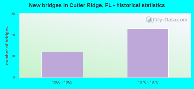
- New bridges - historical statistics
- 121960-1969
- 231970-1979

- Reconstructed bridges - Historical Statistics
- 61970-1979
- 01980-1989
- 01990-1999
- 22000-2009
- 82010-2019


- Bridge Condition - Deck
- 8.7%Very good
- 69.6%Good
- 8.7%Satisfactory
- 8.7%Fair
- 4.3%Poor

- Bridge Condition - Superstructure
- 8.7%Very good
- 73.9%Good
- 4.3%Satisfactory
- 8.7%Fair
- 4.3%Poor

- Bridge Condition - Substructure
- 4.3%Very good
- 95.7%Good

- Bridge Condition - Channel
- 69.2%Good
- 23.1%Satisfactory
- 7.7%Poor
Find on map >> Show street view
Structure Number: 870013, Location: 0.36ml N of SW 216 St (Lat: 25.570556, Lng: -80.377639), Route carried "on" structure: US US-1, Year Built: 1962, Year Reconstructed: 2005, Status: Open, Structure Length: 3.29m (10.79ft), Average Daily Traffic: 19,500 (year 2020), Truck Traffic: 6%, Average Future Daily Traffic: 33,832 (year 2042), Design Load: HS 20, Features Intersected: BLACK CREEK CANAL C-1
Minimum Vertical Clearance: 30+ m (98+ ft), Kilometerpoint: 18.551, Lanes on structure: 2, Base Highway Network: Yes, Owner: State Highway Agency, Approaching Roadway Width: 12.1m (39.7ft), Material/Design: Prestressed concrete, Design/Construction: Slab, Number Of Spans In Main Unit: 3, Length of Maximum Span: 11.0m (36.1ft), Curb or Sidewalk Widths: Left: 2.6m (8.5ft), Right: 0.0m, Curb-To-Curb Width: 11.6m (38.1ft), Out-to-Out Width: 15.4m (50.5ft)
Condition: Deck: Good, Superstructure: Good, Substructure: Good, Channel: Good, Operating Rating: 51.5 metric tons, Method Used To Determine Operating Rating: Load Factor (LF), Inventory Rating: 31.3 metric tons, Method Used To Determine Inventory Rating: Load Factor (LF), Structural Evaluation: Better than present minimum criteria, Deck Geometry: Better than present minimum criteria, Waterway Adequacy: Better than present minimum criteria, Approach Roadway Alignment: Equal to present desirable criteria, Designated Inspection Frequency: Every 24 months, Underwater Inspection Frequency: Every 24 months, Inspection Date: January 2022, Underwater Inspection Date: January 2022, Bridge Improvement Cost: $501,000, Total Project Cost: $501,000, Deck Structure Type: Concrete Precast Panels, Wearing Surface/Protective System: Wearing Surface: Bituminous
Find on map >> Show street view
Structure Number: 870014, Location: 0.5ml S of SW 186 St (Lat: 25.592228, Lng: -80.357372), Route carried "on" structure: US US-1, Year Built: 1963, Year Reconstructed: 1970, Status: Open, Structure Length: 2.01m (6.59ft), Average Daily Traffic: 25,000 (year 2020), Truck Traffic: 9%, Average Future Daily Traffic: 43,375 (year 2042), Design Load: HS 20, Features Intersected: CANAL C-1-N Belle Aire
Minimum Vertical Clearance: 30+ m (98+ ft), Kilometerpoint: 21.716, Lanes on structure: 3, Base Highway Network: Yes, Owner: State Highway Agency, Approaching Roadway Width: 15.0m (49.2ft), Material/Design: Concrete, Design/Construction: Slab, Number Of Spans In Main Unit: 3, Length of Maximum Span: 6.7m (22.0ft), Curb or Sidewalk Widths: Left: 1.3m (4.3ft), Right: 0.6m (2.0ft), Curb-To-Curb Width: 15.0m (49.2ft), Out-to-Out Width: 15.6m (51.2ft)
Condition: Deck: Good, Superstructure: Good, Substructure: Good, Channel: Good, Operating Rating: 70.7 metric tons, Method Used To Determine Operating Rating: Load Factor (LF), Inventory Rating: 42.5 metric tons, Method Used To Determine Inventory Rating: Load Factor (LF), Structural Evaluation: Better than present minimum criteria, Deck Geometry: Equal to present minimum criteria, Waterway Adequacy: Better than present minimum criteria, Approach Roadway Alignment: Equal to present desirable criteria, Length Of Structure Improvement: 2.01m (6.59ft), Designated Inspection Frequency: Every 24 months, Underwater Inspection Frequency: Every 24 months, Inspection Date: January 2022, Underwater Inspection Date: January 2022, Bridge Improvement Cost: $77,000, Total Project Cost: $77,000, Deck Structure Type: Concrete Cast-file-Place, Wearing Surface/Protective System: Wearing Surface: Bituminous
Find on map >> Show street view
Structure Number: 870015, Location: N OF SW 158 ST (Lat: 25.623836, Lng: -80.343511), Route carried "on" structure: US 1, Year Built: 1964, Year Reconstructed: 1970, Status: Open, Structure Length: 2.74m (8.99ft), Average Daily Traffic: 25,750 (year 2020), Truck Traffic: 6%, Average Future Daily Traffic: 44,676 (year 2042), Design Load: HS 20, Features Intersected: CUTLER DRAIN-CANAL C-100
Minimum Vertical Clearance: 30+ m (98+ ft), Kilometerpoint: 25.553, Lanes on structure: 3, Owner: State Highway Agency, Approaching Roadway Width: 12.8m (42.0ft), Material/Design: Prestressed concrete, Design/Construction: Slab, Number Of Spans In Main Unit: 3, Length of Maximum Span: 9.1m (29.9ft), Curb or Sidewalk Widths: Left: 1.0m (3.3ft), Right: 0.0m, Curb-To-Curb Width: 12.8m (42.0ft), Out-to-Out Width: 15.2m (49.9ft)
Condition: Deck: Good, Superstructure: Good, Substructure: Good, Channel: Good, Operating Rating: 73.4 metric tons, Method Used To Determine Operating Rating: Load Factor (LF), Inventory Rating: 44.0 metric tons, Method Used To Determine Inventory Rating: Load Factor (LF), Structural Evaluation: Better than present minimum criteria, Deck Geometry: Meets minimum limits, Waterway Adequacy: Equal to present desirable criteria, Approach Roadway Alignment: Equal to present desirable criteria, Length Of Structure Improvement: 2.01m (6.59ft), Designated Inspection Frequency: Every 24 months, Underwater Inspection Frequency: Every 24 months, Inspection Date: January 2022, Underwater Inspection Date: January 2022, Bridge Improvement Cost: $87,000, Total Project Cost: $77,000, Deck Structure Type: Concrete Precast Panels, Wearing Surface/Protective System: Wearing Surface: Bituminous
Find on map >> Show street view
Structure Number: 870016, Location: SW 139 St (Lat: 25.641308, Lng: -80.335406), Route carried "on" structure: US 1, Year Built: 1965, Year Reconstructed: 1970, Status: Open, Structure Length: 1.92m (6.30ft), Average Daily Traffic: 25,750 (year 2020), Truck Traffic: 6%, Average Future Daily Traffic: 44,676 (year 2042), Design Load: HS 20, Features Intersected: CANAL C-100-C, Facility Carried by Structure: SR-5 SB (870233)
Minimum Vertical Clearance: 30+ m (98+ ft), Kilometerpoint: 27.658, Lanes on structure: 3, Owner: State Highway Agency, Approaching Roadway Width: 13.1m (43.0ft), Material/Design: Concrete, Design/Construction: Slab, Number Of Spans In Main Unit: 3, Length of Maximum Span: 6.4m (21.0ft), Curb or Sidewalk Widths: Left: 1.3m (4.3ft), Right: 0.0m, Curb-To-Curb Width: 12.9m (42.3ft), Out-to-Out Width: 15.2m (49.9ft)
Condition: Deck: Very good, Superstructure: Very good, Substructure: Good, Channel: Good, Operating Rating: 66.4 metric tons, Method Used To Determine Operating Rating: Load Factor (LF), Inventory Rating: 39.6 metric tons, Method Used To Determine Inventory Rating: Load Factor (LF), Structural Evaluation: Better than present minimum criteria, Deck Geometry: Meets minimum limits, Waterway Adequacy: Better than present minimum criteria, Approach Roadway Alignment: Equal to present desirable criteria, Designated Inspection Frequency: Every 24 months, Underwater Inspection Frequency: Every 24 months, Inspection Date: October 2021, Underwater Inspection Date: October 2021, Deck Structure Type: Concrete Cast-file-Place, Wearing Surface/Protective System: Wearing Surface: Bituminous
Find on map >> Show street view
Structure Number: 870184, Location: 0.4 MILES SOUTH OF US-1 (Lat: 25.577044, Lng: -80.364858), Route carried "on" structure: State highway 821, Year Built: 1972, Year Reconstructed: 2016, Status: Open, Structure Length: 7.46m (24.48ft), Average Daily Traffic: 65,850 (year 2020), Truck Traffic: 8%, Average Future Daily Traffic: 114,250 (year 2042), Design Load: HL 93, Features Intersected: CARIBBEAN BLVD
Minimum Vertical Clearance: 30+ m (98+ ft), Kilometerpoint: 20.146, Lanes on structure: 3, Lanes under structure: 6, Base Highway Network: Yes, Toll: On toll road, Owner: State Toll Authority, Approaching Roadway Width: 22.7m (74.5ft), Skew: 3 degrees, Material/Design: Prestressed concrete, Design/Construction: Stringer/Multi-beam, Number Of Spans In Main Unit: 4, Length of Maximum Span: 22.7m (74.5ft), Curb-To-Curb Width: 22.7m (74.5ft), Out-to-Out Width: 26.8m (87.9ft)
Condition: Deck: Good, Superstructure: Good, Substructure: Good, Operating Rating: 47.3 metric tons, Method Used To Determine Operating Rating: Load and Resistance Factor (LRFR), Inventory Rating: 43.3 metric tons, Method Used To Determine Inventory Rating: Load and Resistance Factor (LRFR), Structural Evaluation: Better than present minimum criteria, Deck Geometry: Superior to present desirable criteria, Underclear: Better than present minimum criteria, Approach Roadway Alignment: Equal to present desirable criteria, Designated Inspection Frequency: Every 24 months, Inspection Date: March 2020, Deck Structure Type: Concrete Cast-file-Place
Find on map >> Show street view
Structure Number: 870185, Location: 0.9 MI S OF QUAIL ROOST D (Lat: 25.582192, Lng: -80.366397), Route carried "on" structure: State highway 821, Year Built: 1972, Year Reconstructed: 2016, Status: Open, Structure Length: 12.07m (39.60ft), Average Daily Traffic: 65,850 (year 2020), Truck Traffic: 8%, Average Future Daily Traffic: 114,250 (year 2042), Design Load: HL 93, Features Intersected: US 1 & METRO-DADE BUS RT
Minimum Vertical Clearance: 30+ m (98+ ft), Kilometerpoint: 20.701, Lanes on structure: 5, Lanes under structure: 8, Base Highway Network: Yes, Toll: On toll road, Owner: State Toll Authority, Approaching Roadway Width: 24.4m (80.1ft), Skew: 3 degrees, Material/Design: Steel, Design/Construction: Stringer/Multi-beam, Number Of Spans In Main Unit: 4, Length of Maximum Span: 46.0m (150.9ft), Curb-To-Curb Width: 24.4m (80.1ft), Out-to-Out Width: 25.3m (83.0ft)
Condition: Deck: Satisfactory, Superstructure: Good, Substructure: Good, Operating Rating: 44.1 metric tons, Method Used To Determine Operating Rating: Load and Resistance Factor (LRFR), Inventory Rating: 33.9 metric tons, Method Used To Determine Inventory Rating: Load and Resistance Factor (LRFR), Structural Evaluation: Better than present minimum criteria, Deck Geometry: Equal to present minimum criteria, Underclear: Equal to present minimum criteria, Approach Roadway Alignment: Equal to present desirable criteria, Designated Inspection Frequency: Every 24 months, Inspection Date: March 2020, Deck Structure Type: Concrete Cast-file-Place
Find on map >> Show street view
Structure Number: 870194, Location: 0.9 MILES NORTH OF US-1 (Lat: 25.595303, Lng: -80.372353), Route carried "on" structure: State highway 821, Year Built: 1973, Year Reconstructed: 2016, Status: Open, Structure Length: 7.21m (23.65ft), Average Daily Traffic: 65,850 (year 2020), Truck Traffic: 8%, Average Future Daily Traffic: 114,250 (year 2042), Design Load: HS 20, Features Intersected: QUAIL ROOST DR
Minimum Vertical Clearance: 30+ m (98+ ft), Kilometerpoint: 22.355, Lanes on structure: 4, Lanes under structure: 7, Base Highway Network: Yes, Toll: On toll road, Owner: State Toll Authority, Approaching Roadway Width: 24.4m (80.1ft), Skew: 3 degrees, Material/Design: Prestressed concrete, Design/Construction: Stringer/Multi-beam, Number Of Spans In Main Unit: 4, Length of Maximum Span: 21.7m (71.2ft), Curb-To-Curb Width: 24.4m (80.1ft), Out-to-Out Width: 25.3m (83.0ft)
Condition: Deck: Good, Superstructure: Good, Substructure: Good, Operating Rating: 59.8 metric tons, Method Used To Determine Operating Rating: Load Factor (LF), Inventory Rating: 35.6 metric tons, Method Used To Determine Inventory Rating: Load Factor (LF), Structural Evaluation: Better than present minimum criteria, Deck Geometry: Superior to present desirable criteria, Underclear: Equal to present minimum criteria, Approach Roadway Alignment: Equal to present desirable criteria, Designated Inspection Frequency: Every 24 months, Inspection Date: March 2020, Deck Structure Type: Concrete Cast-file-Place
Find on map >> Show street view
Structure Number: 870197, Location: 2.3 MILES NORTH OF US-1 (Lat: 25.612589, Lng: -80.378606), Route carried "on" structure: State highway 821, Year Built: 1973, Year Reconstructed: 2019, Status: Open, Structure Length: 5.21m (17.09ft), Average Daily Traffic: 79,200 (year 2020), Truck Traffic: 8%, Average Future Daily Traffic: 137,412 (year 2042), Design Load: HS 20, Features Intersected: SW 168 ST
Minimum Vertical Clearance: 30+ m (98+ ft), Kilometerpoint: 24.441, Lanes on structure: 5, Lanes under structure: 2, Base Highway Network: Yes, Toll: On toll road, Owner: State Toll Authority, Approaching Roadway Width: 29.1m (95.5ft), Material/Design: Prestressed concrete, Design/Construction: Stringer/Multi-beam, Number Of Spans In Main Unit: 3, Number Of Approach Spans: 2, Length of Maximum Span: 28.0m (91.9ft), Curb-To-Curb Width: 29.1m (95.5ft), Out-to-Out Width: 44.3m (145.3ft)
Condition: Deck: Good, Superstructure: Good, Substructure: Good, Operating Rating: 55.2 metric tons, Method Used To Determine Operating Rating: Load and Resistance Factor (LRFR), Inventory Rating: 36.6 metric tons, Method Used To Determine Inventory Rating: Load and Resistance Factor (LRFR), Structural Evaluation: Better than present minimum criteria, Deck Geometry: Superior to present desirable criteria, Underclear: Better than present minimum criteria, Approach Roadway Alignment: Equal to present desirable criteria, Designated Inspection Frequency: Every 24 months, Inspection Date: March 2020, Deck Structure Type: Concrete Cast-file-Place
Find on map >> Show street view
Structure Number: 87023, Location: 0.36ml N of SW 216 St. (Lat: 25.570372, Lng: -80.377539), Route carried "on" structure: US US-1, Year Built: 1962, Year Reconstructed: 2005, Status: Open, Structure Length: 3.29m (10.79ft), Average Daily Traffic: 19,500 (year 2020), Truck Traffic: 6%, Average Future Daily Traffic: 33,832 (year 2042), Design Load: HS 20, Features Intersected: BLACK CREEK CANAL C-1-W
Minimum Vertical Clearance: 30+ m (98+ ft), Kilometerpoint: 18.551, Lanes on structure: 2, Base Highway Network: Yes, Owner: State Highway Agency, Approaching Roadway Width: 11.4m (37.4ft), Material/Design: Prestressed concrete, Design/Construction: Slab, Number Of Spans In Main Unit: 3, Length of Maximum Span: 11.0m (36.1ft), Curb or Sidewalk Widths: Left: 0.0m, Right: 1.9m (6.2ft), Curb-To-Curb Width: 9.7m (31.8ft), Out-to-Out Width: 13.2m (43.3ft)
Condition: Deck: Good, Superstructure: Good, Substructure: Good, Channel: Good, Operating Rating: 53.5 metric tons, Method Used To Determine Operating Rating: Load Factor (LF), Inventory Rating: 32.7 metric tons, Method Used To Determine Inventory Rating: Load Factor (LF), Structural Evaluation: Better than present minimum criteria, Deck Geometry: Meets minimum limits, Waterway Adequacy: Better than present minimum criteria, Approach Roadway Alignment: Equal to present desirable criteria, Designated Inspection Frequency: Every 24 months, Underwater Inspection Frequency: Every 24 months, Inspection Date: January 2022, Underwater Inspection Date: January 2022, Deck Structure Type: Concrete Precast Panels, Wearing Surface/Protective System: Wearing Surface: Bituminous
Find on map >> Show street view
Structure Number: 870231, Location: 0.5 ml S of SW 186 St (Lat: 25.592206, Lng: -80.357197), Route carried "on" structure: US US-1, Year Built: 1963, Year Reconstructed: 1970, Status: Open, Structure Length: 2.01m (6.59ft), Average Daily Traffic: 25,000 (year 2020), Truck Traffic: 9%, Average Future Daily Traffic: 43,375 (year 2042), Design Load: HS 20, Features Intersected: CANAL C-1-N Belle Aire
Minimum Vertical Clearance: 30+ m (98+ ft), Kilometerpoint: 21.716, Lanes on structure: 3, Base Highway Network: Yes, Owner: State Highway Agency, Approaching Roadway Width: 12.8m (42.0ft), Material/Design: Concrete, Design/Construction: Slab, Number Of Spans In Main Unit: 3, Length of Maximum Span: 6.7m (22.0ft), Curb or Sidewalk Widths: Left: 0.0m, Right: 1.3m (4.3ft), Curb-To-Curb Width: 12.5m (41.0ft), Out-to-Out Width: 14.8m (48.6ft)
Condition: Deck: Good, Superstructure: Good, Substructure: Good, Channel: Good, Operating Rating: 70.7 metric tons, Method Used To Determine Operating Rating: Load Factor (LF), Inventory Rating: 42.5 metric tons, Method Used To Determine Inventory Rating: Load Factor (LF), Structural Evaluation: Better than present minimum criteria, Deck Geometry: Meets minimum limits, Waterway Adequacy: Better than present minimum criteria, Approach Roadway Alignment: Equal to present desirable criteria, Designated Inspection Frequency: Every 24 months, Underwater Inspection Frequency: Every 24 months, Inspection Date: January 2022, Underwater Inspection Date: January 2022, Deck Structure Type: Concrete Cast-file-Place, Wearing Surface/Protective System: Wearing Surface: Bituminous
Find on map >> Show street view
Structure Number: 870232, Location: SW 158 ST (Lat: 25.623781, Lng: -80.343344), Route carried "on" structure: US 5, Year Built: 1964, Year Reconstructed: 1970, Status: Open, Structure Length: 2.74m (8.99ft), Average Daily Traffic: 25,750 (year 2020), Truck Traffic: 6%, Average Future Daily Traffic: 44,676 (year 2042), Design Load: HS 20, Features Intersected: CUTLER DRAIN-CANAL C-100
Minimum Vertical Clearance: 30+ m (98+ ft), Kilometerpoint: 25.553, Lanes on structure: 3, Owner: State Highway Agency, Approaching Roadway Width: 13.0m (42.7ft), Material/Design: Prestressed concrete, Design/Construction: Slab, Number Of Spans In Main Unit: 3, Length of Maximum Span: 9.1m (29.9ft), Curb or Sidewalk Widths: Left: 0.0m, Right: 2.0m (6.6ft), Curb-To-Curb Width: 13.0m (42.7ft), Out-to-Out Width: 14.6m (47.9ft)
Condition: Deck: Good, Superstructure: Good, Substructure: Good, Channel: Good, Operating Rating: 73.4 metric tons, Method Used To Determine Operating Rating: Load Factor (LF), Inventory Rating: 44.0 metric tons, Method Used To Determine Inventory Rating: Load Factor (LF), Structural Evaluation: Better than present minimum criteria, Deck Geometry: Meets minimum limits, Waterway Adequacy: Better than present minimum criteria, Approach Roadway Alignment: Equal to present desirable criteria, Length Of Structure Improvement: 2.74m (8.99ft), Designated Inspection Frequency: Every 24 months, Underwater Inspection Frequency: Every 24 months, Inspection Date: January 2022, Underwater Inspection Date: January 2022, Bridge Improvement Cost: $85,000, Total Project Cost: $85,000, Deck Structure Type: Concrete Precast Panels, Wearing Surface/Protective System: Wearing Surface: Bituminous
Find on map >> Show street view
Structure Number: 870233, Location: SW 139 ST (Lat: 25.641278, Lng: -80.335278), Route carried "on" structure: US 1, Year Built: 1965, Year Reconstructed: 1970, Status: Open, Structure Length: 1.92m (6.30ft), Average Daily Traffic: 25,750 (year 2020), Truck Traffic: 6%, Average Future Daily Traffic: 44,676 (year 2042), Design Load: HS 20, Features Intersected: CANAL C-100-C
Minimum Vertical Clearance: 30+ m (98+ ft), Kilometerpoint: 27.658, Lanes on structure: 3, Base Highway Network: Yes, Owner: State Highway Agency, Approaching Roadway Width: 13.1m (43.0ft), Material/Design: Concrete, Design/Construction: Slab, Number Of Spans In Main Unit: 3, Length of Maximum Span: 6.4m (21.0ft), Curb or Sidewalk Widths: Left: 0.0m, Right: 2.0m (6.6ft), Curb-To-Curb Width: 12.3m (40.4ft), Out-to-Out Width: 14.9m (48.9ft)
Condition: Deck: Very good, Superstructure: Very good, Substructure: Good, Channel: Good, Operating Rating: 56.3 metric tons, Method Used To Determine Operating Rating: Load Factor (LF), Inventory Rating: 33.6 metric tons, Method Used To Determine Inventory Rating: Load Factor (LF), Structural Evaluation: Better than present minimum criteria, Deck Geometry: Meets minimum limits, Waterway Adequacy: Better than present minimum criteria, Approach Roadway Alignment: Equal to present desirable criteria, Designated Inspection Frequency: Every 24 months, Underwater Inspection Frequency: Every 24 months, Inspection Date: October 2021, Underwater Inspection Date: October 2021, Deck Structure Type: Concrete Cast-file-Place, Wearing Surface/Protective System: Wearing Surface: Bituminous
Find on map >> Show street view
Structure Number: 870388, Location: 1.6 MILES SOUTH OF US 1 (Lat: 25.559433, Lng: -80.362714), Route carried "on" structure: State highway 821, Year Built: 1973, Status: Open, Structure Length: 5.66m (18.57ft), Average Daily Traffic: 46,850 (year 2020), Truck Traffic: 8%, Average Future Daily Traffic: 81,285 (year 2042), Design Load: HS 20+Mod, Features Intersected: OLD CUTLER RD
Minimum Vertical Clearance: 30+ m (98+ ft), Kilometerpoint: 18.163, Lanes on structure: 3, Lanes under structure: 2, Base Highway Network: Yes, Toll: On toll road, Owner: State Toll Authority, Approaching Roadway Width: 17.7m (58.1ft), Skew: 1 degrees, Material/Design: Prestressed concrete, Design/Construction: Stringer/Multi-beam, Number Of Spans In Main Unit: 3, Length of Maximum Span: 30.5m (100.1ft), Curb-To-Curb Width: 17.1m (56.1ft), Out-to-Out Width: 18.0m (59.1ft)
Condition: Deck: Good, Superstructure: Good, Substructure: Good, Operating Rating: 54.2 metric tons, Method Used To Determine Operating Rating: Load and Resistance Factor (LRFR), Inventory Rating: 30.7 metric tons, Method Used To Determine Inventory Rating: Load and Resistance Factor (LRFR), Structural Evaluation: Better than present minimum criteria, Deck Geometry: Equal to present minimum criteria, Underclear: Superior to present desirable criteria, Approach Roadway Alignment: Equal to present desirable criteria, Designated Inspection Frequency: Every 24 months, Inspection Date: March 2020, Deck Structure Type: Concrete Cast-file-Place
Find on map >> Show street view
Structure Number: 870397, Location: 0.4 MILES SOUTH OF US-1 (Lat: 25.576878, Lng: -80.364481), Route carried "on" structure: State highway 821, Year Built: 1972, Status: Open, Structure Length: 7.22m (23.69ft), Average Daily Traffic: 65,850 (year 2020), Truck Traffic: 8%, Average Future Daily Traffic: 114,250 (year 2042), Design Load: HL 93, Features Intersected: CARIBBEAN BLVD
Minimum Vertical Clearance: 30+ m (98+ ft), Kilometerpoint: 20.107, Lanes on structure: 4, Lanes under structure: 6, Base Highway Network: Yes, Toll: On toll road, Owner: State Toll Authority, Approaching Roadway Width: 19.5m (64.0ft), Skew: 3 degrees, Material/Design: Prestressed concrete, Design/Construction: Stringer/Multi-beam, Number Of Spans In Main Unit: 4, Length of Maximum Span: 21.3m (69.9ft), Curb-To-Curb Width: 19.5m (64.0ft), Out-to-Out Width: 20.2m (66.3ft)
Condition: Deck: Good, Superstructure: Good, Substructure: Good, Operating Rating: 46.1 metric tons, Method Used To Determine Operating Rating: Load and Resistance Factor (LRFR), Inventory Rating: 34.3 metric tons, Method Used To Determine Inventory Rating: Load and Resistance Factor (LRFR), Structural Evaluation: Better than present minimum criteria, Deck Geometry: Somewhat better than minimum adequacy, Underclear: Better than present minimum criteria, Approach Roadway Alignment: Equal to present desirable criteria, Designated Inspection Frequency: Every 24 months, Inspection Date: March 2020, Deck Structure Type: Concrete Cast-file-Place
Find on map >> Show street view
Structure Number: 870398, Location: 0.9 MI S OF QUAIL ROOST D (Lat: 25.582450, Lng: -80.366139), Route carried "on" structure: State highway 821, Year Built: 1972, Year Reconstructed: 2016, Status: Open, Structure Length: 12.07m (39.60ft), Average Daily Traffic: 65,850 (year 2020), Truck Traffic: 8%, Average Future Daily Traffic: 114,250 (year 2042), Design Load: HL 93, Features Intersected: US 1 & METRO-DADE BUS RT
Minimum Vertical Clearance: 30+ m (98+ ft), Kilometerpoint: 20.732, Lanes on structure: 5, Lanes under structure: 8, Base Highway Network: Yes, Owner: State Toll Authority, Approaching Roadway Width: 24.4m (80.1ft), Skew: 3 degrees, Material/Design: Steel, Design/Construction: Stringer/Multi-beam, Number Of Spans In Main Unit: 4, Length of Maximum Span: 45.6m (149.6ft), Curb-To-Curb Width: 24.4m (80.1ft), Out-to-Out Width: 25.3m (83.0ft)
Condition: Deck: Satisfactory, Superstructure: Satisfactory, Substructure: Good, Operating Rating: 44.1 metric tons, Method Used To Determine Operating Rating: Load and Resistance Factor (LRFR), Inventory Rating: 33.9 metric tons, Method Used To Determine Inventory Rating: Load and Resistance Factor (LRFR), Structural Evaluation: Equal to present minimum criteria, Deck Geometry: Equal to present minimum criteria, Underclear: Equal to present minimum criteria, Approach Roadway Alignment: Equal to present desirable criteria, Designated Inspection Frequency: Every 24 months, Inspection Date: March 2020, Deck Structure Type: Concrete Cast-file-Place
Find on map >> Show street view
Structure Number: 870401, Location: 0.9 MILES NORTH OF US 1 (Lat: 25.595375, Lng: -80.371972), Route carried "on" structure: State highway 821, Year Built: 1973, Year Reconstructed: 2016, Status: Open, Structure Length: 7.21m (23.65ft), Average Daily Traffic: 65,850 (year 2020), Truck Traffic: 8%, Average Future Daily Traffic: 114,250 (year 2042), Design Load: HS 20, Features Intersected: QUAIL ROOST DR
Minimum Vertical Clearance: 30+ m (98+ ft), Kilometerpoint: 22.320, Lanes on structure: 5, Lanes under structure: 7, Base Highway Network: Yes, Toll: On toll road, Owner: State Toll Authority, Approaching Roadway Width: 24.4m (80.1ft), Skew: 3 degrees, Material/Design: Prestressed concrete, Design/Construction: Stringer/Multi-beam, Number Of Spans In Main Unit: 4, Length of Maximum Span: 21.7m (71.2ft), Curb-To-Curb Width: 24.4m (80.1ft), Out-to-Out Width: 25.3m (83.0ft)
Condition: Deck: Good, Superstructure: Good, Substructure: Good, Operating Rating: 59.8 metric tons, Method Used To Determine Operating Rating: Load Factor (LF), Inventory Rating: 35.6 metric tons, Method Used To Determine Inventory Rating: Load Factor (LF), Structural Evaluation: Better than present minimum criteria, Deck Geometry: Equal to present minimum criteria, Underclear: Equal to present minimum criteria, Approach Roadway Alignment: Equal to present desirable criteria, Designated Inspection Frequency: Every 24 months, Inspection Date: March 2020, Deck Structure Type: Concrete Cast-file-Place
Find on map >> Show street view
Structure Number: 870403, Location: 1.2 MILES NORTH OF US-1 (Lat: 25.597825, Lng: -80.374844), Route carried "on" structure: State highway 821, Year Built: 1973, Year Reconstructed: 2016, Status: Open, Structure Length: 8.74m (28.67ft), Average Daily Traffic: 79,200 (year 2020), Truck Traffic: 8%, Average Future Daily Traffic: 137,412 (year 2042), Design Load: HL 93, Features Intersected: SW 184 ST EUREKA DR
Minimum Vertical Clearance: 30+ m (98+ ft), Kilometerpoint: 22.700, Lanes on structure: 3, Lanes under structure: 7, Base Highway Network: Yes, Toll: On toll road, Owner: State Toll Authority, Approaching Roadway Width: 24.4m (80.1ft), Skew: 3 degrees, Material/Design: Prestressed concrete, Design/Construction: Stringer/Multi-beam, Number Of Spans In Main Unit: 4, Length of Maximum Span: 27.8m (91.2ft), Curb-To-Curb Width: 24.4m (80.1ft), Out-to-Out Width: 25.3m (83.0ft)
Condition: Deck: Good, Superstructure: Good, Substructure: Good, Operating Rating: 69.9 metric tons, Method Used To Determine Operating Rating: Load and Resistance Factor (LRFR), Inventory Rating: 57.2 metric tons, Method Used To Determine Inventory Rating: Load and Resistance Factor (LRFR), Structural Evaluation: Better than present minimum criteria, Deck Geometry: Superior to present desirable criteria, Underclear: Equal to present minimum criteria, Approach Roadway Alignment: Equal to present desirable criteria, Designated Inspection Frequency: Every 24 months, Inspection Date: March 2020, Deck Structure Type: Concrete Cast-file-Place
Find on map >> Show street view
Structure Number: 870404, Location: 2.3 MILES NORTH OF US-1 (Lat: 25.612608, Lng: -80.378272), Route carried "on" structure: State highway 821, Year Built: 1973, Year Reconstructed: 2019, Status: Open, Structure Length: 5.27m (17.29ft), Average Daily Traffic: 79,200 (year 2020), Truck Traffic: 8%, Average Future Daily Traffic: 137,412 (year 2042), Design Load: HS 20, Features Intersected: SW 168 ST
Minimum Vertical Clearance: 30+ m (98+ ft), Kilometerpoint: 24.441, Lanes on structure: 5, Lanes under structure: 2, Base Highway Network: Yes, Toll: On toll road, Owner: State Toll Authority, Approaching Roadway Width: 29.1m (95.5ft), Material/Design: Prestressed concrete, Design/Construction: Stringer/Multi-beam, Number Of Spans In Main Unit: 3, Length of Maximum Span: 28.3m (92.8ft), Curb-To-Curb Width: 29.1m (95.5ft), Out-to-Out Width: 30.0m (98.4ft)
Condition: Deck: Good, Superstructure: Good, Substructure: Good, Operating Rating: 55.9 metric tons, Method Used To Determine Operating Rating: Load and Resistance Factor (LRFR), Inventory Rating: 37.6 metric tons, Method Used To Determine Inventory Rating: Load and Resistance Factor (LRFR), Structural Evaluation: Better than present minimum criteria, Deck Geometry: Superior to present desirable criteria, Underclear: Better than present minimum criteria, Approach Roadway Alignment: Equal to present desirable criteria, Designated Inspection Frequency: Every 24 months, Inspection Date: March 2020, Deck Structure Type: Concrete Cast-file-Place
Find on map >> Show street view
Structure Number: 874296, Location: 0.8Mi. W of Old Cutler Rd (Lat: 25.570139, Lng: -80.360111), Route carried "on" structure: County highway , Year Built: 1960, Status: Open, Structure Length: 0.64m (2.10ft), Average Daily Traffic: 220 (year 2014), Truck Traffic: 2%, Average Future Daily Traffic: 360 (year 2039), Design Load: HS 20, Features Intersected: Canal C-100-B, Facility Carried by Structure: SW 212th Street
Minimum Vertical Clearance: 30+ m (98+ ft), Kilometerpoint: 0.101, Lanes on structure: 2, Owner: County Highway Agency, Approaching Roadway Width: 6.1m (20.0ft), Material/Design: Concrete, Design/Construction: Slab, Number Of Spans In Main Unit: 1, Length of Maximum Span: 6.4m (21.0ft), Curb or Sidewalk Widths: Left: 1.2m (3.9ft), Right: 1.2m (3.9ft), Curb-To-Curb Width: 8.6m (28.2ft), Out-to-Out Width: 11.5m (37.7ft)
Condition: Deck: Good, Superstructure: Good, Substructure: Very good, Channel: Satisfactory, Operating Rating: 59.2 metric tons, Method Used To Determine Operating Rating: Load Factor (LF), Inventory Rating: 35.5 metric tons, Method Used To Determine Inventory Rating: Load Factor (LF), Structural Evaluation: Better than present minimum criteria, Deck Geometry: Equal to present minimum criteria, Waterway Adequacy: Better than present minimum criteria, Approach Roadway Alignment: Equal to present desirable criteria, Designated Inspection Frequency: Every 24 months, Inspection Date: March 2020, Deck Structure Type: Concrete Cast-file-Place, Wearing Surface/Protective System: Wearing Surface: Monolithic Concrete
Find on map >> Show street view
Structure Number: 87443, Location: 0.3 Mile E of US-1 (Lat: 25.585861, Lng: -80.355278), Route carried "on" structure: County highway , Year Built: 1967, Status: Open, Structure Length: 4.11m (13.48ft), Average Daily Traffic: 7,113 (year 2020), Truck Traffic: 2%, Average Future Daily Traffic: 11,504 (year 2041), Design Load: HL 93, Features Intersected: Bel Aire Canal C-1-N, Facility Carried by Structure: Marlin Road
Minimum Vertical Clearance: 30+ m (98+ ft), Kilometerpoint: 0.541, Lanes on structure: 2, Owner: County Highway Agency, Approaching Roadway Width: 8.7m (28.5ft), Material/Design: Prestressed concrete, Design/Construction: Slab, Number Of Spans In Main Unit: 3, Length of Maximum Span: 13.8m (45.3ft), Curb or Sidewalk Widths: Left: 1.2m (3.9ft), Right: 1.2m (3.9ft), Curb-To-Curb Width: 8.7m (28.5ft), Out-to-Out Width: 11.7m (38.4ft)
Condition: Deck: Poor, Superstructure: Poor, Substructure: Good, Channel: Good, Operating Rating: 54.3 metric tons, Method Used To Determine Operating Rating: Load and Resistance Factor (LRFR), Inventory Rating: 41.9 metric tons, Method Used To Determine Inventory Rating: Load and Resistance Factor (LRFR), Structural Evaluation: Meets minimum limits, Deck Geometry: High priority of replacement, Waterway Adequacy: Equal to present desirable criteria, Approach Roadway Alignment: Equal to present desirable criteria, Designated Inspection Frequency: Every 24 months, Underwater Inspection Frequency: Every 24 months, Other Special Inspection Frequency: Every 12 months, Inspection Date: March 2020, Underwater Inspection Date: March 2020, Other Special Inspection Date: March 2021, Deck Structure Type: Concrete Precast Panels, Wearing Surface/Protective System: Wearing Surface: Bituminous
Find on map >> Show street view
Structure Number: 874431, Location: 200ft. E Of SW 103rd Ave. (Lat: 25.576306, Lng: -80.360194), Route carried "on" structure: County highway , Year Built: 1963, Status: Open, Structure Length: 0.89m (2.92ft), Average Daily Traffic: 20,849 (year 2020), Truck Traffic: 4%, Average Future Daily Traffic: 33,624 (year 2042), Design Load: HS 20, Features Intersected: Bel Aire Canal C-1-N, Facility Carried by Structure: Caribbean Blvd.
Minimum Vertical Clearance: 30+ m (98+ ft), Kilometerpoint: 0.958, Lanes on structure: 2, Owner: County Highway Agency, Approaching Roadway Width: 8.6m (28.2ft), Material/Design: Prestressed concrete, Design/Construction: Slab, Number Of Spans In Main Unit: 1, Length of Maximum Span: 8.9m (29.2ft), Curb or Sidewalk Widths: Left: 1.2m (3.9ft), Right: 1.2m (3.9ft), Curb-To-Curb Width: 8.6m (28.2ft), Out-to-Out Width: 11.6m (38.1ft)
Condition: Deck: Fair, Superstructure: Fair, Substructure: Good, Channel: Poor, Operating Rating: 45.1 metric tons, Method Used To Determine Operating Rating: Load Factor (LF), Inventory Rating: 30.0 metric tons, Method Used To Determine Inventory Rating: Load Factor (LF), Structural Evaluation: Somewhat better than minimum adequacy, Deck Geometry: High priority of replacement, Waterway Adequacy: Better than present minimum criteria, Approach Roadway Alignment: Equal to present desirable criteria, Designated Inspection Frequency: Every 24 months, Underwater Inspection Frequency: Every 12 months, Other Special Inspection Frequency: Every 12 months, Inspection Date: April 2020, Underwater Inspection Date: April 2021, Other Special Inspection Date: April 2021, Deck Structure Type: Concrete Precast Panels, Wearing Surface/Protective System: Wearing Surface: Bituminous
Find on map >> Show street view
Structure Number: 874432, Location: 0.7Mile S of SW 216th St. (Lat: 25.559278, Lng: -80.359167), Route carried "on" structure: County highway , Year Built: 1962, Status: Open, Structure Length: 3.48m (11.42ft), Average Daily Traffic: 10,139 (year 2014), Truck Traffic: 5%, Average Future Daily Traffic: 16,197 (year 2036), Design Load: HS 20, Features Intersected: Black Creek Canal, Facility Carried by Structure: Old Cutler Road
Minimum Vertical Clearance: 30+ m (98+ ft), Kilometerpoint: 0.333, Lanes on structure: 2, Owner: County Highway Agency, Approaching Roadway Width: 8.6m (28.2ft), Material/Design: Prestressed concrete, Design/Construction: Slab, Number Of Spans In Main Unit: 3, Length of Maximum Span: 11.6m (38.1ft), Curb or Sidewalk Widths: Left: 1.2m (3.9ft), Right: 1.2m (3.9ft), Curb-To-Curb Width: 8.6m (28.2ft), Out-to-Out Width: 11.6m (38.1ft)
Condition: Deck: Fair, Superstructure: Fair, Substructure: Good, Channel: Satisfactory, Operating Rating: 30.7 metric tons, Method Used To Determine Operating Rating: Load Factor (LF), Inventory Rating: 24.6 metric tons, Method Used To Determine Inventory Rating: Load Factor (LF), Structural Evaluation: Somewhat better than minimum adequacy, Deck Geometry: High priority of replacement, Waterway Adequacy: Better than present minimum criteria, Approach Roadway Alignment: Equal to present minimum criteria, Designated Inspection Frequency: Every 24 months, Underwater Inspection Frequency: Every 24 months, Inspection Date: March 2020, Underwater Inspection Date: March 2020, Deck Structure Type: Concrete Precast Panels, Wearing Surface/Protective System: Wearing Surface: Bituminous
Find on map >> Show street view
Structure Number: 874434, Location: 200Ft. E of Fla. Turnpike (Lat: 25.566333, Lng: -80.362167), Route carried "on" structure: County highway , Year Built: 1975, Status: Open, Structure Length: 4.49m (14.73ft), Average Daily Traffic: 16,018 (year 2014), Truck Traffic: 3%, Average Future Daily Traffic: 26,826 (year 2036), Design Load: HS 20, Features Intersected: Black Creek, Facility Carried by Structure: SW 216th Street
Minimum Vertical Clearance: 30+ m (98+ ft), Kilometerpoint: 7.115, Lanes on structure: 6, Owner: County Highway Agency, Approaching Roadway Width: 25.3m (83.0ft), Skew: 20 degrees, Material/Design: Prestressed concrete, Design/Construction: Stringer/Multi-beam, Number Of Spans In Main Unit: 3, Length of Maximum Span: 15.0m (49.2ft), Curb or Sidewalk Widths: Left: 3.1m (10.2ft), Right: 1.9m (6.2ft), Curb-To-Curb Width: 25.3m (83.0ft), Out-to-Out Width: 38.3m (125.7ft)
Condition: Deck: Good, Superstructure: Good, Substructure: Good, Channel: Satisfactory, Operating Rating: 72.8 metric tons, Method Used To Determine Operating Rating: Load Factor (LF), Inventory Rating: 38.2 metric tons, Method Used To Determine Inventory Rating: Load Factor (LF), Structural Evaluation: Better than present minimum criteria, Deck Geometry: Somewhat better than minimum adequacy, Waterway Adequacy: Equal to present desirable criteria, Approach Roadway Alignment: Equal to present desirable criteria, Designated Inspection Frequency: Every 24 months, Underwater Inspection Frequency: Every 24 months, Inspection Date: March 2020, Underwater Inspection Date: March 2020, Deck Structure Type: Concrete Cast-file-Place, Wearing Surface/Protective System: Wearing Surface: Monolithic Concrete
Find on map >> Show street view
Structure Number: 870184, Location: 0.4 MILES SOUTH OF US-1 (Lat: 25.577044, Lng: -80.364858), Route carried "under" structure: City street , Year Built: 1972, Structure Length: 0. m, Average Daily Traffic: 65,850 (year 2020), Truck Traffic: 8%, Features Intersected: CARIBBEAN BLVD, Facility Carried by Structure: SR821 SB HEFT 12.5
Minimum Vertical Clearance: 5.21m (17.09ft), Kilometerpoint: 20.146, Lanes on structure: 3, Lanes under structure: 6, Material/Design: Prestressed concrete, Design/Construction: Stringer/Multi-beam, Length of Maximum Span: 22.7m (74.5ft)
Find on map >> Show street view
Structure Number: 870185, Location: 0.9 MI S OF QUAIL ROOST D (Lat: 25.582192, Lng: -80.366397), Route carried "under" structure: US 1, Year Built: 1972, Structure Length: 0. m, Average Daily Traffic: 63,500 (year 2020), Truck Traffic: 7%, Features Intersected: US 1 & METRO-DADE BUS RT
Minimum Vertical Clearance: 6.19m (20.31ft), Kilometerpoint: 0.000, Lanes on structure: 5, Lanes under structure: 6, Material/Design: Steel, Design/Construction: Stringer/Multi-beam, Length of Maximum Span: 46.0m (150.9ft)
Find on map >> Show street view
Structure Number: 870185, Location: 0.9 MI S OF QUAIL ROOST D (Lat: 25.582192, Lng: -80.366397), Route carried "under" structure: City street , Year Built: 1972, Structure Length: 0. m, Average Daily Traffic: 1,000 (year 2020), Truck Traffic: 7%, Features Intersected: US 1 & METRO-DADE BUS RT, Facility Carried by Structure: SR821 SB HEFT 12.8
Minimum Vertical Clearance: 7.32m (24.02ft), Kilometerpoint: 0.000, Lanes on structure: 5, Lanes under structure: 2, Material/Design: Steel, Design/Construction: Stringer/Multi-beam, Length of Maximum Span: 46.0m (150.9ft)
Find on map >> Show street view
Structure Number: 870194, Location: 0.9 MILES NORTH OF US-1 (Lat: 25.595303, Lng: -80.372353), Route carried "under" structure: State highway 994, Year Built: 1973, Structure Length: 0. m, Average Daily Traffic: 65,850 (year 2020), Truck Traffic: 8%, Features Intersected: QUAIL ROOST DR, Facility Carried by Structure: SR821 HEFT SB 13.9
Minimum Vertical Clearance: 5.18m (16.99ft), Kilometerpoint: 22.355, Lanes on structure: 4, Lanes under structure: 7, Material/Design: Prestressed concrete, Design/Construction: Stringer/Multi-beam, Length of Maximum Span: 21.7m (71.2ft)
Find on map >> Show street view
Structure Number: 870197, Location: 2.3 MILES NORTH OF US-1 (Lat: 25.612589, Lng: -80.378606), Route carried "under" structure: City street , Year Built: 1973, Structure Length: 0. m, Average Daily Traffic: 8,400 (year 2020), Truck Traffic: 2%, Features Intersected: SW 168 ST, Facility Carried by Structure: SR821 SB HEFT 15.2
Minimum Vertical Clearance: 4.88m (16.01ft), Kilometerpoint: 0.309, Lanes on structure: 5, Lanes under structure: 2, Material/Design: Prestressed concrete, Design/Construction: Stringer/Multi-beam, Length of Maximum Span: 28.0m (91.9ft)
Find on map >> Show street view
Structure Number: 870388, Location: 1.6 MILES SOUTH OF US 1 (Lat: 25.559433, Lng: -80.362714), Route carried "under" structure: City street , Year Built: 1973, Structure Length: 0. m, Average Daily Traffic: 46,850 (year 2020), Truck Traffic: 8%, Features Intersected: OLD CUTLER RD, Facility Carried by Structure: SR821 NB HEFT 11.2
Minimum Vertical Clearance: 5.27m (17.29ft), Kilometerpoint: 18.163, Lanes on structure: 3, Lanes under structure: 2, Material/Design: Prestressed concrete, Design/Construction: Stringer/Multi-beam, Length of Maximum Span: 30.5m (100.1ft)
Find on map >> Show street view
Structure Number: 870397, Location: 0.4 MILES SOUTH OF US-1 (Lat: 25.576878, Lng: -80.364481), Route carried "under" structure: City street , Year Built: 1972, Structure Length: 0. m, Average Daily Traffic: 65,850 (year 2020), Truck Traffic: 8%, Features Intersected: CARIBBEAN BLVD, Facility Carried by Structure: SR821 HEFT NB 12.4
Minimum Vertical Clearance: 5.21m (17.09ft), Kilometerpoint: 20.107, Lanes on structure: 4, Lanes under structure: 6, Material/Design: Prestressed concrete, Design/Construction: Stringer/Multi-beam, Length of Maximum Span: 21.3m (69.9ft)
Find on map >> Show street view
Structure Number: 870398, Location: 0.9 MI S OF QUAIL ROOST D (Lat: 25.582450, Lng: -80.366139), Route carried "under" structure: City street , Year Built: 1972, Structure Length: 0. m, Average Daily Traffic: 1,000 (year 2020), Truck Traffic: 7%, Features Intersected: US 1 & METRO-DADE BUS RT, Facility Carried by Structure: SR821 HEFT NB 12.8
Minimum Vertical Clearance: 7.32m (24.02ft), Kilometerpoint: 0.000, Lanes on structure: 5, Lanes under structure: 2, Material/Design: Steel, Design/Construction: Stringer/Multi-beam, Length of Maximum Span: 45.6m (149.6ft)
Find on map >> Show street view
Structure Number: 870398, Location: 0.9 MI S OF QUAIL ROOST D (Lat: 25.582450, Lng: -80.366139), Route carried "under" structure: US 1, Year Built: 1972, Structure Length: 0. m, Average Daily Traffic: 63,500 (year 2020), Truck Traffic: 7%, Features Intersected: US 1 & METRO-DADE BUS RT
Minimum Vertical Clearance: 6.19m (20.31ft), Kilometerpoint: 0.000, Lanes on structure: 5, Lanes under structure: 6, Material/Design: Steel, Design/Construction: Stringer/Multi-beam, Length of Maximum Span: 45.6m (149.6ft)
Find on map >> Show street view
Structure Number: 870401, Location: 0.9 MILES NORTH OF US 1 (Lat: 25.595375, Lng: -80.371972), Route carried "under" structure: State highway 994, Year Built: 1973, Structure Length: 0. m, Average Daily Traffic: 65,850 (year 2020), Truck Traffic: 8%, Features Intersected: QUAIL ROOST DR, Facility Carried by Structure: SR821 NB HEFT 13.8
Minimum Vertical Clearance: 5.12m (16.80ft), Kilometerpoint: 22.320, Lanes on structure: 5, Lanes under structure: 7, Material/Design: Prestressed concrete, Design/Construction: Stringer/Multi-beam, Length of Maximum Span: 21.7m (71.2ft)
Find on map >> Show street view
Structure Number: 870403, Location: 1.2 MILES NORTH OF US-1 (Lat: 25.597825, Lng: -80.374844), Route carried "under" structure: City street , Year Built: 1973, Structure Length: 0. m, Average Daily Traffic: 17,500 (year 2020), Truck Traffic: 11%, Features Intersected: SW 184 ST EUREKA DR, Facility Carried by Structure: SR821 NB HEFT 14.1
Minimum Vertical Clearance: 5.09m (16.70ft), Kilometerpoint: 0.607, Lanes on structure: 3, Lanes under structure: 7, Material/Design: Prestressed concrete, Design/Construction: Stringer/Multi-beam, Length of Maximum Span: 27.8m (91.2ft)
Find on map >> Show street view
Structure Number: 870404, Location: 2.3 MILES NORTH OF US-1 (Lat: 25.612608, Lng: -80.378272), Route carried "under" structure: City street , Year Built: 1973, Structure Length: 0. m, Average Daily Traffic: 79,200 (year 2020), Truck Traffic: 8%, Features Intersected: SW 168 ST, Facility Carried by Structure: SR821 NB HEFT 15.2
Minimum Vertical Clearance: 4.88m (16.01ft), Kilometerpoint: 24.441, Lanes on structure: 5, Lanes under structure: 2, Material/Design: Prestressed concrete, Design/Construction: Stringer/Multi-beam, Length of Maximum Span: 28.3m (92.8ft)