Bridge Statistics for Damascus, Virginia (VA)
Condition, Traffic, Stress, Structural Evaluation, Project Costs
- National Bridge Inventory (NBI) Statistics
- 36Number of bridges
- 374ft / 114mTotal length
- $9,549,000Total costs
- 711,486Total average daily traffic
- 48,488Total average daily truck traffic
- National Bridge Inventory (NBI) Registered Bridges for Damascus
- No street view available for this location
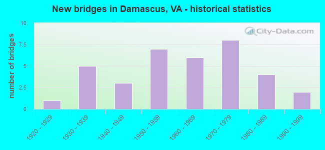
- New bridges - historical statistics
- 11920-1929
- 51930-1939
- 31940-1949
- 71950-1959
- 61960-1969
- 81970-1979
- 41980-1989
- 21990-1999

- Reconstructed bridges - Historical Statistics
- 11970-1979
- 11980-1989
- 21990-1999
- 52000-2009
- 22010-2019


- Bridge Condition - Deck
- 8.0%Very good
- 40.0%Good
- 36.0%Satisfactory
- 8.0%Fair
- 4.0%Poor
- 4.0%Failed

- Bridge Condition - Superstructure
- 20.0%Very good
- 20.0%Good
- 36.0%Satisfactory
- 16.0%Fair
- 4.0%Serious
- 4.0%Failed

- Bridge Condition - Substructure
- 8.0%Very good
- 24.0%Good
- 32.0%Satisfactory
- 36.0%Fair

- Bridge Condition - Channel
- 17.9%Very good
- 14.3%Good
- 32.1%Satisfactory
- 35.7%Fair

- Bridge Condition - Culverts
- 20.0%Very good
- 20.0%Good
- 50.0%Satisfactory
- 10.0%Fair
Find on map >> Show street view
Structure Number: 641, Location: 0.55 FR 668 / 0.61 TO 667 (Lat: 38.180389, Lng: -78.574508), Route carried "on" structure: County highway 601, Year Built: 1959, Status: Open, Structure Length: 0.67m (2.20ft), Average Daily Traffic: 874 (year 2020), Truck Traffic: 3%, Average Future Daily Traffic: 1,061 (year 2040), Design Load: H 20, Features Intersected: PINEY CREEK, Facility Carried by Structure: FREE UNION ROAD
Minimum Vertical Clearance: 30+ m (98+ ft), Kilometerpoint: 19.205, Lanes on structure: 2, Owner: State Highway Agency, Approaching Roadway Width: 4.9m (16.1ft), Material/Design: Steel, Design/Construction: Culvert, Number Of Spans In Main Unit: 3, Length of Maximum Span: 1.8m (5.9ft)
Condition: Channel: Fair, Culverts: Very good, Operating Rating: 44.5 metric tons, Method Used To Determine Operating Rating: Field evaluation and documented engineering judgment, Inventory Rating: 32.7 metric tons, Method Used To Determine Inventory Rating: Field evaluation and documented engineering judgment, Structural Evaluation: Equal to present desirable criteria, Waterway Adequacy: Equal to present minimum criteria, Approach Roadway Alignment: Equal to present minimum criteria, Length Of Structure Improvement: 1.07m (3.51ft), Designated Inspection Frequency: Every 24 months, Inspection Date: December 2020, Bridge Improvement Cost: $200,000, Roadway Improvement Cost: $90,000, Total Project Cost: $310,000
Find on map >> Show street view
Structure Number: 386, Location: .06MFR1009;.0MTO460 (Lat: 37.271281, Lng: -82.107758), Route carried "on" structure: County highway 615, Year Built: 1957, Status: Open, Structure Length: 3.20m (10.50ft), Average Daily Traffic: 838 (year 2015), Average Future Daily Traffic: 943 (year 2040), Design Load: HS 15, Features Intersected: LEVISA RIVER, Facility Carried by Structure: HOOT OWL RD.
Minimum Vertical Clearance: 30+ m (98+ ft), Kilometerpoint: 5.006, Lanes on structure: 2, Owner: State Highway Agency, Approaching Roadway Width: 9.4m (30.8ft), Material/Design: Concrete continuous, Design/Construction: Slab, Number Of Spans In Main Unit: 3, Length of Maximum Span: 12.2m (40.0ft), Curb or Sidewalk Widths: Left: 0.5m (1.6ft), Right: 0.5m (1.6ft), Curb-To-Curb Width: 7.3m (24.0ft), Out-to-Out Width: 9.0m (29.5ft)
Condition: Deck: Fair, Superstructure: Fair, Substructure: Satisfactory, Channel: Satisfactory, Operating Rating: 45.4 metric tons, Method Used To Determine Operating Rating: Load Factor (LF), Inventory Rating: 27.2 metric tons, Method Used To Determine Inventory Rating: Load Factor (LF), Structural Evaluation: Somewhat better than minimum adequacy, Deck Geometry: Meets minimum limits, Waterway Adequacy: Better than present minimum criteria, Approach Roadway Alignment: Better than present minimum criteria, Length Of Structure Improvement: 3.20m (10.50ft), Designated Inspection Frequency: Every 24 months, Inspection Date: September 2020, Bridge Improvement Cost: $59,000, Roadway Improvement Cost: $10,000, Total Project Cost: $90,000, Deck Structure Type: Concrete Cast-file-Place
Find on map >> Show street view
Structure Number: 5575, Location: 1.75 From663 &.90 To15Bus (Lat: 38.498139, Lng: -77.925722), Route carried "on" structure: US 15, Year Built: 1975, Status: Open, Structure Length: 1.34m (4.40ft), Average Daily Traffic: 47,651 (year 2020), Truck Traffic: 9%, Average Future Daily Traffic: 57,072 (year 2040), Design Load: HS 20, Features Intersected: Jonas Run, Facility Carried by Structure: James Madison Hwy.
Minimum Vertical Clearance: 30+ m (98+ ft), Kilometerpoint: 264.716, Lanes on structure: 4, Base Highway Network: Yes, Owner: State Highway Agency, Approaching Roadway Width: 14.6m (47.9ft), Skew: 4 degrees, Material/Design: Concrete, Design/Construction: Culvert, Number Of Spans In Main Unit: 3, Length of Maximum Span: 4.3m (14.1ft)
Condition: Channel: Satisfactory, Culverts: Satisfactory, Operating Rating: 89.8 metric tons, Method Used To Determine Operating Rating: Load Factor (LF), Inventory Rating: 89.8 metric tons, Method Used To Determine Inventory Rating: Load Factor (LF), Structural Evaluation: Equal to present minimum criteria, Waterway Adequacy: Equal to present desirable criteria, Approach Roadway Alignment: Equal to present desirable criteria, Designated Inspection Frequency: Every 24 months, Inspection Date: November 2020
Find on map >> Show street view
Structure Number: 6409, Location: 01.88FR241/1.50TO613 (Lat: 38.801514, Lng: -77.112161), Route carried "on" structure: Interstate 95, Year Built: 1963, Status: Open, Structure Length: 3.93m (12.89ft), Average Daily Traffic: 147,588 (year 2020), Truck Traffic: 8%, Average Future Daily Traffic: 168,999 (year 2040), Design Load: HS 20, Features Intersected: EISENHOWER CONN. 1148
Minimum Vertical Clearance: 30+ m (98+ ft), Kilometerpoint: 280.240, Lanes on structure: 8, Lanes under structure: 6, Base Highway Network: Yes, Owner: State Highway Agency, Approaching Roadway Width: 17.4m (57.1ft), Material/Design: Prestressed concrete, Design/Construction: Stringer/Multi-beam, Number Of Spans In Main Unit: 3, Length of Maximum Span: 14.0m (45.9ft), Curb or Sidewalk Widths: Left: 0.2m (0.7ft), Right: 0.2m (0.7ft), Curb-To-Curb Width: 43.3m (142.1ft), Out-to-Out Width: 45.7m (149.9ft)
Condition: Deck: Good, Superstructure: Satisfactory, Substructure: Satisfactory, Operating Rating: 59.9 metric tons, Method Used To Determine Operating Rating: Load Factor (LF), Inventory Rating: 36.3 metric tons, Method Used To Determine Inventory Rating: Load Factor (LF), Structural Evaluation: Equal to present minimum criteria, Deck Geometry: Superior to present desirable criteria, Underclear: Better than present minimum criteria, Approach Roadway Alignment: Equal to present desirable criteria, Designated Inspection Frequency: Every 24 months, Inspection Date: January 2022, Bridge Improvement Cost: $200,000, Total Project Cost: $200,000, Deck Structure Type: Concrete Cast-file-Place, Wearing Surface/Protective System: Wearing Surface: Bituminous
Find on map >> Show street view
Structure Number: 6411, Location: 02.16FR.I395/03.21TO241 (Lat: 38.796192, Lng: -77.135786), Route carried "on" structure: Interstate 95, Year Built: 1964, Status: Open, Structure Length: 4.94m (16.21ft), Average Daily Traffic: 160,647 (year 2020), Truck Traffic: 8%, Average Future Daily Traffic: 224,906 (year 2040), Design Load: HS 20, Features Intersected: VAN DORN ST. (RTE. 613), Facility Carried by Structure: CAPITAL BELTWAY
Minimum Vertical Clearance: 30+ m (98+ ft), Kilometerpoint: 18.552, Lanes on structure: 10, Lanes under structure: 4, Base Highway Network: Yes, Owner: State Highway Agency, Approaching Roadway Width: 24.4m (80.1ft), Skew: 23 degrees, Material/Design: Steel, Design/Construction: Stringer/Multi-beam, Number Of Spans In Main Unit: 3, Length of Maximum Span: 23.5m (77.1ft), Curb or Sidewalk Widths: Left: 0.3m (1.0ft), Right: 0.3m (1.0ft), Curb-To-Curb Width: 46.3m (151.9ft), Out-to-Out Width: 47.5m (155.8ft)
Condition: Deck: Fair, Superstructure: Satisfactory, Substructure: Fair, Operating Rating: 51.9 metric tons, Method Used To Determine Operating Rating: Load and Resistance Factor (LRFR), Inventory Rating: 40.0 metric tons, Method Used To Determine Inventory Rating: Load and Resistance Factor (LRFR), Structural Evaluation: Somewhat better than minimum adequacy, Deck Geometry: Superior to present desirable criteria, Underclear: Meets minimum limits, Approach Roadway Alignment: Better than present minimum criteria, Length Of Structure Improvement: 4.94m (16.21ft), Designated Inspection Frequency: Every 24 months, Inspection Date: September 2021, Bridge Improvement Cost: $4,491,000, Roadway Improvement Cost: $449,000, Total Project Cost: $5,000,000, Deck Structure Type: Concrete Cast-file-Place, Wearing Surface/Protective System: Wearing Surface: Bituminous
Find on map >> Show street view
Structure Number: 6415, Location: 01.17FR1/00.17TO241 (Lat: 38.799900, Lng: -77.074800), Route carried "on" structure: Interstate 95, Year Built: 1964, Status: Open, Structure Length: 0.98m (3.22ft), Average Daily Traffic: 207,460 (year 2020), Truck Traffic: 6%, Average Future Daily Traffic: 228,206 (year 2040), Design Load: HS 20, Features Intersected: TAYLOR RUN
Minimum Vertical Clearance: 30+ m (98+ ft), Kilometerpoint: 284.117, Lanes on structure: 11, Base Highway Network: Yes, Owner: State Highway Agency, Approaching Roadway Width: 45.7m (149.9ft), Material/Design: Concrete, Design/Construction: Culvert, Number Of Spans In Main Unit: 3, Length of Maximum Span: 3.0m (9.8ft)
Condition: Channel: Fair, Culverts: Satisfactory, Operating Rating: 68.0 metric tons, Method Used To Determine Operating Rating: Load Factor (LF), Inventory Rating: 40.8 metric tons, Method Used To Determine Inventory Rating: Load Factor (LF), Structural Evaluation: Equal to present minimum criteria, Waterway Adequacy: Better than present minimum criteria, Approach Roadway Alignment: Equal to present desirable criteria, Length Of Structure Improvement: 42.95m (140.91ft), Designated Inspection Frequency: Every 24 months, Inspection Date: July 2020, Bridge Improvement Cost: $61,000, Roadway Improvement Cost: $250,000, Total Project Cost: $400,000
Find on map >> Show street view
Structure Number: 8254, Location: 0.06 TO 779 - 0.02 TO 807 (Lat: 39.171400, Lng: -78.141581), Route carried "on" structure: County highway 657, Year Built: 1971, Status: Open, Structure Length: 1.95m (6.40ft), Average Daily Traffic: 10,131 (year 2020), Truck Traffic: 1%, Average Future Daily Traffic: 13,973 (year 2040), Design Load: HS 20+Mod, Features Intersected: ABRAMS CREEK, Facility Carried by Structure: SENSENY RD
Minimum Vertical Clearance: 30+ m (98+ ft), Kilometerpoint: 0.756, Lanes on structure: 2, Owner: State Highway Agency, Approaching Roadway Width: 9.1m (29.9ft), Material/Design: Concrete, Design/Construction: Slab, Number Of Spans In Main Unit: 2, Length of Maximum Span: 9.8m (32.2ft), Curb-To-Curb Width: 10.4m (34.1ft), Out-to-Out Width: 11.0m (36.1ft)
Condition: Deck: Good, Superstructure: Good, Substructure: Fair, Channel: Very good, Operating Rating: 53.3 metric tons, Method Used To Determine Operating Rating: Load Factor (LF), Inventory Rating: 32.7 metric tons, Method Used To Determine Inventory Rating: Load Factor (LF), Structural Evaluation: Somewhat better than minimum adequacy, Deck Geometry: Meets minimum limits, Waterway Adequacy: Somewhat better than minimum adequacy, Approach Roadway Alignment: Equal to present minimum criteria, Designated Inspection Frequency: Every 24 months, Inspection Date: October 2020, Deck Structure Type: Concrete Cast-file-Place, Wearing Surface/Protective System: Wearing Surface: Epoxy Overlay
Find on map >> Show street view
Structure Number: 8375, Location: 0.23-WVA LINE;3.20-RT 219 (Lat: 37.369131, Lng: -80.867647), Route carried "on" structure: US 460, Year Built: 1969, Status: Open, Structure Length: 8.45m (27.72ft), Average Daily Traffic: 5,146 (year 2020), Truck Traffic: 10%, Average Future Daily Traffic: 7,206 (year 2040), Design Load: HS 20+Mod, Features Intersected: EAST RIVER
Minimum Vertical Clearance: 30+ m (98+ ft), Kilometerpoint: 129.248, Lanes on structure: 2, Base Highway Network: Yes, Owner: State Highway Agency, Approaching Roadway Width: 11.0m (36.1ft), Skew: 1 degrees, Material/Design: Steel continuous, Design/Construction: Stringer/Multi-beam, Number Of Spans In Main Unit: 3, Length of Maximum Span: 32.6m (107.0ft), Curb or Sidewalk Widths: Left: 0.0m, Right: 1.5m (4.9ft), Curb-To-Curb Width: 12.1m (39.7ft), Out-to-Out Width: 14.1m (46.3ft)
Condition: Deck: Satisfactory, Superstructure: Satisfactory, Substructure: Good, Channel: Good, Operating Rating: 74.4 metric tons, Method Used To Determine Operating Rating: Load and Resistance Factor (LRFR), Inventory Rating: 57.2 metric tons, Method Used To Determine Inventory Rating: Load and Resistance Factor (LRFR), Structural Evaluation: Equal to present minimum criteria, Deck Geometry: Better than present minimum criteria, Waterway Adequacy: Equal to present desirable criteria, Approach Roadway Alignment: Equal to present desirable criteria, Designated Inspection Frequency: Every 24 months, Inspection Date: October 2021, Deck Structure Type: Concrete Cast-file-Place, Wearing Surface/Protective System: Wearing Surface: Epoxy Overlay
Find on map >> Show street view
Structure Number: 9107, Location: 1.00 Miles to Route 622 (Lat: 36.567697, Lng: -77.434233), Route carried "on" structure: County highway 625, Year Built: 1970, Status: Open, Structure Length: 3.20m (10.50ft), Average Daily Traffic: 288 (year 2017), Average Future Daily Traffic: 420 (year 2040), Design Load: HS 20+Mod, Features Intersected: Fountains Creek, Facility Carried by Structure: Creek Road
Minimum Vertical Clearance: 30+ m (98+ ft), Kilometerpoint: 4.700, Lanes on structure: 2, Owner: State Highway Agency, Approaching Roadway Width: 6.1m (20.0ft), Material/Design: Concrete, Design/Construction: Slab, Number Of Spans In Main Unit: 3, Length of Maximum Span: 12.2m (40.0ft), Curb-To-Curb Width: 8.0m (26.2ft), Out-to-Out Width: 9.1m (29.9ft)
Condition: Deck: Satisfactory, Superstructure: Satisfactory, Substructure: Satisfactory, Channel: Good, Operating Rating: 35.5 metric tons, Method Used To Determine Operating Rating: Load and Resistance Factor (LRFR), Inventory Rating: 33.3 metric tons, Method Used To Determine Inventory Rating: Load and Resistance Factor (LRFR), Structural Evaluation: Equal to present minimum criteria, Deck Geometry: Somewhat better than minimum adequacy, Waterway Adequacy: Better than present minimum criteria, Approach Roadway Alignment: Equal to present minimum criteria, Designated Inspection Frequency: Every 24 months, Underwater Inspection Frequency: Every 60 months, Inspection Date: August 2021, Underwater Inspection Date: June 2020, Deck Structure Type: Concrete Cast-file-Place, Wearing Surface/Protective System: Wearing Surface: Epoxy Overlay, Membrane: Epoxy
Find on map >> Show street view
Structure Number: 9296, Location: 1.40 TO 658 - 1.60 TO 656 (Lat: 36.632003, Lng: -79.176328), Route carried "on" structure: County highway 688, Year Built: 1990, Status: Open, Structure Length: 1.28m (4.20ft), Average Daily Traffic: 240 (year 2020), Average Future Daily Traffic: 336 (year 2040), Design Load: HS 20, Features Intersected: Double Creek, Facility Carried by Structure: Kern's Mill Road
Minimum Vertical Clearance: 30+ m (98+ ft), Kilometerpoint: 2.692, Lanes on structure: 2, Owner: State Highway Agency, Approaching Roadway Width: 6.4m (21.0ft), Material/Design: Concrete, Design/Construction: Culvert, Number Of Spans In Main Unit: 4, Length of Maximum Span: 3.0m (9.8ft)
Condition: Channel: Fair, Culverts: Good, Operating Rating: 54.4 metric tons, Method Used To Determine Operating Rating: Load Factor (LF), Inventory Rating: 32.7 metric tons, Method Used To Determine Inventory Rating: Load Factor (LF), Structural Evaluation: Better than present minimum criteria, Waterway Adequacy: Equal to present desirable criteria, Approach Roadway Alignment: Equal to present desirable criteria, Designated Inspection Frequency: Every 24 months, Inspection Date: March 2021
Find on map >> Show street view
Structure Number: 10275, Location: 0.46 DEAD END-0.02 RT 220 (Lat: 38.337019, Lng: -79.631847), Route carried "on" structure: County highway 608, Year Built: 1932, Year Reconstructed: 2018, Status: Open, Structure Length: 2.01m (6.59ft), Average Daily Traffic: 12 (year 2018), Average Future Daily Traffic: 13 (year 2040), Features Intersected: JACKSON RIVER, Facility Carried by Structure: RAVENS RUN ROAD
Minimum Vertical Clearance: 30+ m (98+ ft), Kilometerpoint: 0.032, Lanes on structure: 1, Owner: State Highway Agency, Approaching Roadway Width: 4.0m (13.1ft), Material/Design: Steel, Design/Construction: Truss - Thru, Number Of Spans In Main Unit: 1, Length of Maximum Span: 20.1m (65.9ft), Curb or Sidewalk Widths: Left: 0.2m (0.7ft), Right: 0.2m (0.7ft), Curb-To-Curb Width: 4.6m (15.1ft), Out-to-Out Width: 4.8m (15.7ft)
Condition: Deck: Very good, Superstructure: Very good, Substructure: Very good, Channel: Very good, Operating Rating: 67.1 metric tons, Method Used To Determine Operating Rating: Load and Resistance Factor (LRFR), Inventory Rating: 51.7 metric tons, Method Used To Determine Inventory Rating: Load and Resistance Factor (LRFR), Structural Evaluation: Equal to present desirable criteria, Deck Geometry: Better than present minimum criteria, Waterway Adequacy: Equal to present minimum criteria, Approach Roadway Alignment: Somewhat better than minimum adequacy, Length Of Structure Improvement: 2.01m (6.59ft), Designated Inspection Frequency: Every 24 months, Critical Feature Inspection Frequency: Every 24 months, Inspection Date: August 2021, Critical Feature Inspection Date: August 2021, Bridge Improvement Cost: $118,000, Roadway Improvement Cost: $12,000, Total Project Cost: $187,000 ( Estimate for 2015), Deck Structure Type: Wood or Timber, Wearing Surface/Protective System: Wearing Surface: Bituminous
Find on map >> Show street view
Structure Number: 10293, Location: 0.86 D. END - 1.74 RT 250 (Lat: 38.339883, Lng: -79.389169), Route carried "on" structure: County highway 616, Year Built: 1945, Status: Posted for load, Structure Length: 1.99m (6.53ft), Average Daily Traffic: 14 (year 2018), Average Future Daily Traffic: 16 (year 2040), Features Intersected: SHAW FORK, Facility Carried by Structure: UPPER FORK ROAD
Minimum Vertical Clearance: 30+ m (98+ ft), Kilometerpoint: 0.000, Lanes on structure: 1, Owner: State Highway Agency, Approaching Roadway Width: 3.6m (11.8ft), Material/Design: Steel, Design/Construction: Stringer/Multi-beam, Number Of Spans In Main Unit: 2, Length of Maximum Span: 11.8m (38.7ft), Curb or Sidewalk Widths: Left: 0.2m (0.7ft), Right: 0.2m (0.7ft), Curb-To-Curb Width: 3.6m (11.8ft), Out-to-Out Width: 3.7m (12.1ft)
Condition: Deck: Satisfactory, Superstructure: Fair, Substructure: Good, Channel: Very good, Operating Rating: 19.1 metric tons, Method Used To Determine Operating Rating: Load Factor (LF), Inventory Rating: 11.8 metric tons, Method Used To Determine Inventory Rating: Load Factor (LF), Structural Evaluation: Meets minimum limits, Deck Geometry: High priority of corrective action, Waterway Adequacy: Equal to present minimum criteria, Approach Roadway Alignment: High priority of corrective action, Bridge Posting: Required (Relationship of Operating Rating to Maximum Legal Load: 30.0 - 39.9% below), Length Of Structure Improvement: 1.98m (6.50ft), Designated Inspection Frequency: Every 24 months, Inspection Date: January 2022, Bridge Improvement Cost: $210,000, Roadway Improvement Cost: $20,000, Total Project Cost: $345,000 ( Estimate for 2016), Deck Structure Type: Wood or Timber, Wearing Surface/Protective System: Wearing Surface: Bituminous
Find on map >> Show street view
Structure Number: 10941, Location: .70 END MAINT&.10 TO R58 (Lat: 36.627917, Lng: -83.468106), Route carried "on" structure: County highway 698, Year Built: 1932, Year Reconstructed: 2005, Status: Open, Structure Length: 0.98m (3.22ft), Average Daily Traffic: 61 (year 2018), Average Future Daily Traffic: 68 (year 2040), Design Load: HS 20, Features Intersected: INDIAN CREEK
Minimum Vertical Clearance: 30+ m (98+ ft), Kilometerpoint: 1.117, Lanes on structure: 2, Owner: State Highway Agency, Approaching Roadway Width: 6.1m (20.0ft), Material/Design: Steel, Design/Construction: Stringer/Multi-beam, Number Of Spans In Main Unit: 1, Length of Maximum Span: 9.2m (30.2ft), Curb-To-Curb Width: 6.9m (22.6ft), Out-to-Out Width: 8.0m (26.2ft)
Condition: Deck: Good, Superstructure: Very good, Substructure: Good, Channel: Satisfactory, Operating Rating: 61.7 metric tons, Method Used To Determine Operating Rating: Load Factor (LF), Inventory Rating: 37.2 metric tons, Method Used To Determine Inventory Rating: Load Factor (LF), Structural Evaluation: Better than present minimum criteria, Deck Geometry: Somewhat better than minimum adequacy, Waterway Adequacy: Better than present minimum criteria, Approach Roadway Alignment: Better than present minimum criteria, Length Of Structure Improvement: 0.98m (3.22ft), Designated Inspection Frequency: Every 24 months, Inspection Date: January 2021, Bridge Improvement Cost: $67,000, Roadway Improvement Cost: $20,000, Total Project Cost: $147,000 ( Estimate for 2015), Deck Structure Type: Wood or Timber, Wearing Surface/Protective System: Wearing Surface: Bituminous
Find on map >> Show street view
Structure Number: 11615, Location: 1.31 FR 687 & .9 TO 685 (Lat: 37.045075, Lng: -78.402381), Route carried "on" structure: County highway 628, Year Built: 1968, Status: Open, Structure Length: 0.98m (3.22ft), Average Daily Traffic: 118 (year 2019), Average Future Daily Traffic: 130 (year 2040), Design Load: HS 20, Features Intersected: NORTH MEHERRIN RIVER, Facility Carried by Structure: COUNTY LINE ROAD
Minimum Vertical Clearance: 30+ m (98+ ft), Kilometerpoint: 5.487, Lanes on structure: 2, Owner: State Highway Agency, Approaching Roadway Width: 7.3m (24.0ft), Material/Design: Concrete, Design/Construction: Culvert, Number Of Spans In Main Unit: 3, Length of Maximum Span: 3.0m (9.8ft)
Condition: Channel: Fair, Culverts: Good, Operating Rating: 54.4 metric tons, Method Used To Determine Operating Rating: Field evaluation and documented engineering judgment, Inventory Rating: 32.7 metric tons, Method Used To Determine Inventory Rating: Field evaluation and documented engineering judgment, Structural Evaluation: Better than present minimum criteria, Waterway Adequacy: Somewhat better than minimum adequacy, Approach Roadway Alignment: Equal to present minimum criteria, Length Of Structure Improvement: 1.22m (4.00ft), Designated Inspection Frequency: Every 24 months, Inspection Date: March 2021, Bridge Improvement Cost: $32,000, Roadway Improvement Cost: $16,000, Total Project Cost: $68,000 ( Estimate for 2017)
Find on map >> Show street view
Structure Number: 11971, Location: .19 FR 630 & .8 TO 752 (Lat: 36.647381, Lng: -78.147528), Route carried "on" structure: County highway 629, Year Built: 1973, Status: Open, Structure Length: 0.82m (2.69ft), Average Daily Traffic: 243 (year 2019), Average Future Daily Traffic: 345 (year 2040), Design Load: H 20, Features Intersected: PARHAM CREEK, Facility Carried by Structure: REED ROAD
Minimum Vertical Clearance: 30+ m (98+ ft), Kilometerpoint: 0.314, Lanes on structure: 2, Owner: State Highway Agency, Approaching Roadway Width: 9.1m (29.9ft), Skew: 1 degrees, Material/Design: Steel, Design/Construction: Culvert, Number Of Spans In Main Unit: 3, Length of Maximum Span: 2.1m (6.9ft)
Condition: Channel: Fair, Culverts: Very good, Operating Rating: 54.4 metric tons, Method Used To Determine Operating Rating: Field evaluation and documented engineering judgment, Inventory Rating: 32.7 metric tons, Method Used To Determine Inventory Rating: Field evaluation and documented engineering judgment, Structural Evaluation: Equal to present desirable criteria, Waterway Adequacy: Somewhat better than minimum adequacy, Approach Roadway Alignment: Equal to present desirable criteria, Length Of Structure Improvement: 1.10m (3.61ft), Designated Inspection Frequency: Every 24 months, Inspection Date: Febuary 2022, Bridge Improvement Cost: $840,000, Roadway Improvement Cost: $420,000, Total Project Cost: $1,270,000 ( Estimate for 2016)
Find on map >> Show street view
Structure Number: 12166, Location: 7.21-RT460; 0.21-PULAS CO (Lat: 37.163344, Lng: -80.548997), Route carried "on" structure: State highway 114, Year Built: 1990, Status: Open, Structure Length: 4.51m (14.80ft), Average Daily Traffic: 13,384 (year 2020), Truck Traffic: 2%, Average Future Daily Traffic: 16,217 (year 2040), Design Load: HS 20+Mod, Features Intersected: NS RAILWAY
Minimum Vertical Clearance: 30+ m (98+ ft), Kilometerpoint: 3.990, Lanes on structure: 2, Base Highway Network: Yes, Owner: State Highway Agency, Approaching Roadway Width: 7.3m (24.0ft), Skew: 2 degrees, Material/Design: Steel, Design/Construction: Stringer/Multi-beam, Number Of Spans In Main Unit: 2, Length of Maximum Span: 30.5m (100.1ft), Curb or Sidewalk Widths: Left: 0.2m (0.7ft), Right: 0.2m (0.7ft), Curb-To-Curb Width: 13.1m (43.0ft), Out-to-Out Width: 14.0m (45.9ft)
Condition: Deck: Good, Superstructure: Good, Substructure: Good, Operating Rating: 58.1 metric tons, Method Used To Determine Operating Rating: Load and Resistance Factor (LRFR), Inventory Rating: 44.5 metric tons, Method Used To Determine Inventory Rating: Load and Resistance Factor (LRFR), Structural Evaluation: Better than present minimum criteria, Deck Geometry: Somewhat better than minimum adequacy, Underclear: Equal to present minimum criteria, Approach Roadway Alignment: Equal to present desirable criteria, Designated Inspection Frequency: Every 24 months, Inspection Date: December 2020, Deck Structure Type: Concrete Cast-file-Place, Wearing Surface/Protective System: Wearing Surface: Epoxy Overlay, Deck Protection: Epoxy Coated Reinforcing
Find on map >> Show street view
Structure Number: 12554, Location: 1.40-Rt. 660/0.30-Rt. 658 (Lat: 37.612706, Lng: -78.916917), Route carried "on" structure: County highway 657, Year Built: 1984, Status: Open, Structure Length: 0.75m (2.46ft), Average Daily Traffic: 409 (year 2020), Truck Traffic: 7%, Average Future Daily Traffic: 554 (year 2040), Features Intersected: Taylors Creek, Facility Carried by Structure: Tye River Road
Minimum Vertical Clearance: 30+ m (98+ ft), Kilometerpoint: 10.211, Lanes on structure: 2, Owner: State Highway Agency, Approaching Roadway Width: 6.4m (21.0ft), Skew: 4 degrees, Material/Design: Concrete, Design/Construction: Culvert, Number Of Spans In Main Unit: 2, Length of Maximum Span: 3.6m (11.8ft)
Condition: Channel: Fair, Culverts: Satisfactory, Operating Rating: 89.8 metric tons, Method Used To Determine Operating Rating: Load Factor (LF), Inventory Rating: 89.8 metric tons, Method Used To Determine Inventory Rating: Load Factor (LF), Structural Evaluation: Equal to present minimum criteria, Waterway Adequacy: Equal to present desirable criteria, Approach Roadway Alignment: Equal to present minimum criteria, Designated Inspection Frequency: Every 24 months, Inspection Date: April 2021
Find on map >> Show street view
Structure Number: 12803, Location: .65 FR 626 & .06 TO 664 (Lat: 37.088603, Lng: -78.144203), Route carried "on" structure: State highway 49, Year Built: 1972, Status: Open, Structure Length: 0.65m (2.13ft), Average Daily Traffic: 1,225 (year 2020), Truck Traffic: 5%, Average Future Daily Traffic: 1,348 (year 2040), Design Load: H 20, Features Intersected: WHETSTONE CREEK, Facility Carried by Structure: THE FALLS ROAD
Minimum Vertical Clearance: 30+ m (98+ ft), Kilometerpoint: 95.312, Lanes on structure: 2, Base Highway Network: Yes, Owner: State Highway Agency, Approaching Roadway Width: 10.4m (34.1ft), Skew: 3 degrees, Material/Design: Steel, Design/Construction: Culvert, Number Of Spans In Main Unit: 2, Length of Maximum Span: 2.8m (9.2ft)
Condition: Channel: Fair, Culverts: Fair, Operating Rating: 44.5 metric tons, Method Used To Determine Operating Rating: Field evaluation and documented engineering judgment, Inventory Rating: 32.7 metric tons, Method Used To Determine Inventory Rating: Field evaluation and documented engineering judgment, Structural Evaluation: Somewhat better than minimum adequacy, Waterway Adequacy: Somewhat better than minimum adequacy, Approach Roadway Alignment: Equal to present minimum criteria, Length Of Structure Improvement: 0.61m (2.00ft), Designated Inspection Frequency: Every 24 months, Inspection Date: January 2022, Bridge Improvement Cost: $35,000, Roadway Improvement Cost: $30,000, Total Project Cost: $69,000 ( Estimate for 2015)
Find on map >> Show street view
Structure Number: 13278, Location: 0.95 Rt 790; 0.80 Rt 701 (Lat: 36.632500, Lng: -80.099083), Route carried "on" structure: County highway 628, Year Built: 1961, Status: Posted for load, Structure Length: 1.13m (3.71ft), Average Daily Traffic: 20 (year 2014), Average Future Daily Traffic: 23 (year 2040), Design Load: H 15, Features Intersected: Mill Creek
Minimum Vertical Clearance: 30+ m (98+ ft), Kilometerpoint: 3.057, Lanes on structure: 2, Owner: State Highway Agency, Approaching Roadway Width: 4.0m (13.1ft), Material/Design: Steel, Design/Construction: Stringer/Multi-beam, Number Of Spans In Main Unit: 1, Length of Maximum Span: 11.3m (37.1ft), Curb or Sidewalk Widths: Left: 0.3m (1.0ft), Right: 0.3m (1.0ft), Curb-To-Curb Width: 6.9m (22.6ft), Out-to-Out Width: 7.5m (24.6ft)
Condition: Deck: Very good, Superstructure: Very good, Substructure: Very good, Channel: Good, Operating Rating: 37.2 metric tons, Method Used To Determine Operating Rating: Load and Resistance Factor (LRFR), Inventory Rating: 29.0 metric tons, Method Used To Determine Inventory Rating: Load and Resistance Factor (LRFR), Structural Evaluation: Better than present minimum criteria, Deck Geometry: Somewhat better than minimum adequacy, Waterway Adequacy: Meets minimum limits, Approach Roadway Alignment: Equal to present minimum criteria, Bridge Posting: Required (Relationship of Operating Rating to Maximum Legal Load: 20.0 - 29.9% below), Designated Inspection Frequency: Every 24 months, Inspection Date: August 2021, Deck Structure Type: Wood or Timber, Wearing Surface/Protective System: Wearing Surface: Bituminous
Find on map >> Show street view
Structure Number: 1385, Location: 0.39 Fr 615 & 1.61 To 522 (Lat: 37.613233, Lng: -77.943753), Route carried "on" structure: County highway 621, Year Built: 1978, Status: Open, Structure Length: 0.68m (2.23ft), Average Daily Traffic: 364 (year 2020), Truck Traffic: 2%, Average Future Daily Traffic: 510 (year 2040), Design Load: HS 20+Mod, Features Intersected: SOLOMON'S CREEK, Facility Carried by Structure: COSBY ROAD
Minimum Vertical Clearance: 30+ m (98+ ft), Kilometerpoint: 3.694, Lanes on structure: 2, Owner: State Highway Agency, Approaching Roadway Width: 9.1m (29.9ft), Material/Design: Steel, Design/Construction: Stringer/Multi-beam, Number Of Spans In Main Unit: 1, Length of Maximum Span: 5.8m (19.0ft), Curb-To-Curb Width: 7.5m (24.6ft), Out-to-Out Width: 7.8m (25.6ft)
Condition: Deck: Good, Superstructure: Fair, Substructure: Fair, Channel: Fair, Operating Rating: 59.9 metric tons, Method Used To Determine Operating Rating: Load and Resistance Factor (LRFR), Inventory Rating: 46.2 metric tons, Method Used To Determine Inventory Rating: Load and Resistance Factor (LRFR), Structural Evaluation: Somewhat better than minimum adequacy, Deck Geometry: Somewhat better than minimum adequacy, Waterway Adequacy: Somewhat better than minimum adequacy, Approach Roadway Alignment: Equal to present minimum criteria, Designated Inspection Frequency: Every 24 months, Inspection Date: August 2020, Deck Structure Type: Wood or Timber, Wearing Surface/Protective System: Wearing Surface: Bituminous
Find on map >> Show street view
Structure Number: 18266, Location: 0.83 Mi to Int Rte. 631 (Lat: 36.816278, Lng: -77.455922), Route carried "on" structure: Interstate 95, Year Built: 1982, Status: Open, Structure Length: 3.60m (11.81ft), Average Daily Traffic: 13,044 (year 2020), Truck Traffic: 16%, Average Future Daily Traffic: 18,262 (year 2040), Design Load: HS 20+Mod, Features Intersected: Route 646
Minimum Vertical Clearance: 30+ m (98+ ft), Kilometerpoint: 34.304, Lanes on structure: 2, Lanes under structure: 2, Base Highway Network: Yes, Owner: State Highway Agency, Approaching Roadway Width: 13.4m (44.0ft), Material/Design: Prestressed concrete, Design/Construction: Stringer/Multi-beam, Number Of Spans In Main Unit: 3, Length of Maximum Span: 13.7m (44.9ft), Curb or Sidewalk Widths: Left: 0.2m (0.7ft), Right: 0.2m (0.7ft), Curb-To-Curb Width: 12.3m (40.4ft), Out-to-Out Width: 13.4m (44.0ft)
Condition: Deck: Satisfactory, Superstructure: Satisfactory, Substructure: Fair, Operating Rating: 87.1 metric tons, Method Used To Determine Operating Rating: Load and Resistance Factor (LRFR), Inventory Rating: 58.1 metric tons, Method Used To Determine Inventory Rating: Load and Resistance Factor (LRFR), Structural Evaluation: Somewhat better than minimum adequacy, Deck Geometry: Better than present minimum criteria, Underclear: Meets minimum limits, Approach Roadway Alignment: Equal to present desirable criteria, Designated Inspection Frequency: Every 24 months, Inspection Date: October 2020, Deck Structure Type: Concrete Cast-file-Place, Wearing Surface/Protective System: Wearing Surface: Monolithic Concrete, Deck Protection: Epoxy Coated Reinforcing
Find on map >> Show street view
Structure Number: 18866, Location: .10 FR. T1223-.04TO T1207 (Lat: 36.635564, Lng: -81.791617), Route carried "on" structure: US 58, Year Built: 1926, Year Reconstructed: 1998, Status: Open, Structure Length: 2.53m (8.30ft), Average Daily Traffic: 5,104 (year 2020), Truck Traffic: 4%, Average Future Daily Traffic: 5,614 (year 2040), Design Load: HS 20+Mod, Features Intersected: BEAVERDAM CREEK, Facility Carried by Structure: JEB STUART HWY
Minimum Vertical Clearance: 30+ m (98+ ft), Kilometerpoint: 201.326, Lanes on structure: 2, Base Highway Network: Yes, Owner: State Highway Agency, Approaching Roadway Width: 11.3m (37.1ft), Material/Design: Concrete continuous, Design/Construction: Slab, Number Of Spans In Main Unit: 3, Length of Maximum Span: 8.5m (27.9ft), Curb or Sidewalk Widths: Left: 1.5m (4.9ft), Right: 1.5m (4.9ft), Curb-To-Curb Width: 8.5m (27.9ft), Out-to-Out Width: 12.4m (40.7ft)
Condition: Deck: Satisfactory, Superstructure: Satisfactory, Substructure: Fair, Channel: Satisfactory, Operating Rating: 72.6 metric tons, Method Used To Determine Operating Rating: Load and Resistance Factor (LRFR), Inventory Rating: 56.2 metric tons, Method Used To Determine Inventory Rating: Load and Resistance Factor (LRFR), Structural Evaluation: Somewhat better than minimum adequacy, Deck Geometry: High priority of replacement, Waterway Adequacy: Better than present minimum criteria, Approach Roadway Alignment: Better than present minimum criteria, Designated Inspection Frequency: Every 24 months, Inspection Date: September 2020, Deck Structure Type: Concrete Cast-file-Place, Wearing Surface/Protective System: Deck Protection: Epoxy Coated Reinforcing
Find on map >> Show street view
Structure Number: 18869, Location: 10.75TOI81; 0.15TO RT. 91 (Lat: 36.634178, Lng: -81.785825), Route carried "on" structure: US 58, Year Built: 1949, Year Reconstructed: 2008, Status: Open, Structure Length: 6.74m (22.11ft), Average Daily Traffic: 5,104 (year 2020), Truck Traffic: 4%, Average Future Daily Traffic: 5,614 (year 2040), Design Load: HS 20+Mod, Features Intersected: LAUREL CREEK
Minimum Vertical Clearance: 30+ m (98+ ft), Kilometerpoint: 201.864, Lanes on structure: 2, Base Highway Network: Yes, Owner: State Highway Agency, Approaching Roadway Width: 12.2m (40.0ft), Skew: 3 degrees, Material/Design: Steel, Design/Construction: Stringer/Multi-beam, Number Of Spans In Main Unit: 3, Length of Maximum Span: 25.3m (83.0ft), Curb or Sidewalk Widths: Left: 1.2m (3.9ft), Right: 1.2m (3.9ft), Curb-To-Curb Width: 12.2m (40.0ft), Out-to-Out Width: 15.2m (49.9ft)
Condition: Deck: Good, Superstructure: Very good, Substructure: Satisfactory, Channel: Fair, Operating Rating: 47.2 metric tons, Method Used To Determine Operating Rating: Load and Resistance Factor (LRFR), Inventory Rating: 36.3 metric tons, Method Used To Determine Inventory Rating: Load and Resistance Factor (LRFR), Structural Evaluation: Equal to present minimum criteria, Deck Geometry: Somewhat better than minimum adequacy, Waterway Adequacy: Better than present minimum criteria, Approach Roadway Alignment: Better than present minimum criteria, Designated Inspection Frequency: Every 24 months, Inspection Date: September 2020, Deck Structure Type: Concrete Cast-file-Place
Find on map >> Show street view
Structure Number: 1887, Location: 6.76 FR R11 & 3.85 TO R91 (Lat: 36.650467, Lng: -81.845397), Route carried "on" structure: US 58, Year Built: 1952, Year Reconstructed: 1992, Status: Open, Structure Length: 11.06m (36.29ft), Average Daily Traffic: 5,104 (year 2020), Truck Traffic: 4%, Average Future Daily Traffic: 5,614 (year 2040), Design Load: HS 20+Mod, Features Intersected: SF HOLSTN RV;RTE 711;N&W, Facility Carried by Structure: JEB STUART HWY
Minimum Vertical Clearance: 30+ m (98+ ft), Kilometerpoint: 195.875, Lanes on structure: 2, Lanes under structure: 2, Base Highway Network: Yes, Owner: State Highway Agency, Approaching Roadway Width: 9.8m (32.2ft), Material/Design: Steel, Design/Construction: Stringer/Multi-beam, Number Of Spans In Main Unit: 5, Length of Maximum Span: 24.4m (80.1ft), Curb-To-Curb Width: 8.4m (27.6ft), Out-to-Out Width: 9.4m (30.8ft)
Condition: Deck: Satisfactory, Superstructure: Satisfactory, Substructure: Fair, Channel: Good, Operating Rating: 75.3 metric tons, Method Used To Determine Operating Rating: Load and Resistance Factor (LRFR), Inventory Rating: 58.1 metric tons, Method Used To Determine Inventory Rating: Load and Resistance Factor (LRFR), Structural Evaluation: Somewhat better than minimum adequacy, Deck Geometry: High priority of corrective action, Underclear: Meets minimum limits, Waterway Adequacy: Better than present minimum criteria, Approach Roadway Alignment: Better than present minimum criteria, Length Of Structure Improvement: 11.06m (36.29ft), Designated Inspection Frequency: Every 24 months, Inspection Date: March 2021, Deck Structure Type: Concrete Cast-file-Place, Wearing Surface/Protective System: Deck Protection: Epoxy Coated Reinforcing
Find on map >> Show street view
Structure Number: 18968, Location: 0.4 TO 58;1.22 TOTENN LIN (Lat: 36.623217, Lng: -81.764808), Route carried "on" structure: State highway 91, Year Built: 1950, Year Reconstructed: 1995, Status: Open, Structure Length: 1.86m (6.10ft), Average Daily Traffic: 2,704 (year 2020), Truck Traffic: 7%, Average Future Daily Traffic: 2,974 (year 2040), Design Load: HS 20+Mod, Features Intersected: LAUREL CREEK
Minimum Vertical Clearance: 30+ m (98+ ft), Kilometerpoint: 1.833, Lanes on structure: 2, Owner: State Highway Agency, Approaching Roadway Width: 6.7m (22.0ft), Skew: 4 degrees, Material/Design: Steel, Design/Construction: Stringer/Multi-beam, Number Of Spans In Main Unit: 1, Length of Maximum Span: 18.6m (61.0ft), Curb-To-Curb Width: 9.8m (32.2ft), Out-to-Out Width: 11.0m (36.1ft)
Condition: Deck: Satisfactory, Superstructure: Satisfactory, Substructure: Satisfactory, Channel: Satisfactory, Operating Rating: 72.6 metric tons, Method Used To Determine Operating Rating: Load and Resistance Factor (LRFR), Inventory Rating: 56.2 metric tons, Method Used To Determine Inventory Rating: Load and Resistance Factor (LRFR), Structural Evaluation: Equal to present minimum criteria, Deck Geometry: Meets minimum limits, Waterway Adequacy: Better than present minimum criteria, Approach Roadway Alignment: Better than present minimum criteria, Designated Inspection Frequency: Every 24 months, Inspection Date: March 2020, Deck Structure Type: Concrete Cast-file-Place, Wearing Surface/Protective System: Wearing Surface: Monolithic Concrete, Deck Protection: Epoxy Coated Reinforcing
Find on map >> Show street view
Structure Number: 18969, Location: 0.02 TO 58;1.5 TO TN LINE (Lat: 36.625467, Lng: -81.770197), Route carried "on" structure: State highway 91, Year Built: 1954, Year Reconstructed: 2018, Status: Open, Structure Length: 5.38m (17.65ft), Average Daily Traffic: 2,704 (year 2020), Truck Traffic: 7%, Average Future Daily Traffic: 2,974 (year 2040), Design Load: HL 93, Features Intersected: LAUREL CREEK, Facility Carried by Structure: MOUNTAIN CITY RD
Minimum Vertical Clearance: 30+ m (98+ ft), Kilometerpoint: 2.426, Lanes on structure: 2, Owner: State Highway Agency, Approaching Roadway Width: 6.8m (22.3ft), Skew: 4 degrees, Material/Design: Steel continuous, Design/Construction: Stringer/Multi-beam, Number Of Spans In Main Unit: 4, Length of Maximum Span: 13.0m (42.7ft), Curb-To-Curb Width: 8.0m (26.2ft), Out-to-Out Width: 8.9m (29.2ft)
Condition: Deck: Good, Superstructure: Very good, Substructure: Satisfactory, Channel: Very good, Operating Rating: 72.6 metric tons, Method Used To Determine Operating Rating: Load and Resistance Factor (LRFR), Inventory Rating: 56.2 metric tons, Method Used To Determine Inventory Rating: Load and Resistance Factor (LRFR), Structural Evaluation: Equal to present minimum criteria, Deck Geometry: High priority of corrective action, Waterway Adequacy: Better than present minimum criteria, Approach Roadway Alignment: Better than present minimum criteria, Designated Inspection Frequency: Every 24 months, Inspection Date: August 2020, Deck Structure Type: Concrete Cast-file-Place, Wearing Surface/Protective System: Deck Protection: Other Coated Reinforcing
Find on map >> Show street view
Structure Number: 18982, Location: 4.0 FR 803;4.0 TO 58 (Lat: 36.673933, Lng: -81.807386), Route carried "on" structure: State highway 91, Year Built: 1979, Status: Open, Structure Length: 0.64m (2.10ft), Average Daily Traffic: 1,577 (year 2020), Truck Traffic: 4%, Average Future Daily Traffic: 1,735 (year 2040), Design Load: HS 20, Features Intersected: STREAM
Minimum Vertical Clearance: 30+ m (98+ ft), Kilometerpoint: 10.838, Lanes on structure: 2, Owner: State Highway Agency, Approaching Roadway Width: 10.4m (34.1ft), Skew: 4 degrees, Material/Design: Steel, Design/Construction: Culvert, Number Of Spans In Main Unit: 2, Length of Maximum Span: 2.7m (8.9ft)
Condition: Channel: Fair, Culverts: Satisfactory, Operating Rating: 44.5 metric tons, Method Used To Determine Operating Rating: Field evaluation and documented engineering judgment, Inventory Rating: 32.7 metric tons, Method Used To Determine Inventory Rating: Field evaluation and documented engineering judgment, Structural Evaluation: Equal to present minimum criteria, Waterway Adequacy: Better than present minimum criteria, Approach Roadway Alignment: Better than present minimum criteria, Designated Inspection Frequency: Every 24 months, Inspection Date: December 2020
Find on map >> Show street view
Structure Number: 19212, Location: .10 FR 716; .03 TO 1204 (Lat: 36.631492, Lng: -81.790400), Route carried "on" structure: County highway 1203, Year Built: 1932, Year Reconstructed: 1977, Status: Closed, Structure Length: 1.83m (6.00ft), Average Daily Traffic: 675 (year 2017), Average Future Daily Traffic: 699 (year 2040), Design Load: H 10, Features Intersected: BEAVER DAM CREEK, Facility Carried by Structure: WATER STREET
Minimum Vertical Clearance: 30+ m (98+ ft), Kilometerpoint: 0.063, Lanes on structure: 2, Owner: State Highway Agency, Approaching Roadway Width: 6.1m (20.0ft), Material/Design: Steel, Design/Construction: Stringer/Multi-beam, Number Of Spans In Main Unit: 1, Length of Maximum Span: 18.3m (60.0ft), Curb or Sidewalk Widths: Left: 0.9m (3.0ft), Right: 0.2m (0.7ft), Curb-To-Curb Width: 5.2m (17.1ft), Out-to-Out Width: 7.3m (24.0ft)
Condition: Deck: Poor, Superstructure: Serious, Substructure: Fair, Channel: Satisfactory, Operating Rating: 3.6 metric tons, Method Used To Determine Operating Rating: Load Factor (LF), Inventory Rating: 1.8 metric tons, Method Used To Determine Inventory Rating: Load Factor (LF), Waterway Adequacy: Better than present minimum criteria, Approach Roadway Alignment: Better than present minimum criteria, Bridge Posting: Required (Relationship of Operating Rating to Maximum Legal Load: > 39.9% below), Length Of Structure Improvement: 1.83m (6.00ft), Designated Inspection Frequency: Every 12 months, Inspection Date: Febuary 2022, Bridge Improvement Cost: $105,000, Roadway Improvement Cost: $25,000, Total Project Cost: $169,000, Deck Structure Type: Wood or Timber
Find on map >> Show street view
Structure Number: 19213, Location: 1.00 TO 91 & 0.01 FR. 58 (Lat: 36.629972, Lng: -81.783136), Route carried "on" structure: County highway 1212, Year Built: 1932, Year Reconstructed: 2014, Status: Open, Structure Length: 3.66m (12.01ft), Average Daily Traffic: 230 (year 2017), Average Future Daily Traffic: 256 (year 2040), Design Load: HS 20+Mod, Features Intersected: LAUREL CREEK, Facility Carried by Structure: ORCHARD HILL ROAD
Minimum Vertical Clearance: 30+ m (98+ ft), Kilometerpoint: 0.016, Lanes on structure: 1, Owner: State Highway Agency, Approaching Roadway Width: 5.1m (16.7ft), Material/Design: Concrete, Design/Construction: Slab, Number Of Spans In Main Unit: 3, Length of Maximum Span: 12.2m (40.0ft), Curb or Sidewalk Widths: Left: 0.2m (0.7ft), Right: 0.2m (0.7ft), Curb-To-Curb Width: 4.4m (14.4ft), Out-to-Out Width: 4.4m (14.4ft)
Condition: Deck: Good, Superstructure: Good, Substructure: Satisfactory, Channel: Satisfactory, Operating Rating: 58.1 metric tons, Method Used To Determine Operating Rating: Load and Resistance Factor (LRFR), Inventory Rating: 44.5 metric tons, Method Used To Determine Inventory Rating: Load and Resistance Factor (LRFR), Structural Evaluation: Equal to present minimum criteria, Deck Geometry: High priority of replacement, Waterway Adequacy: Better than present minimum criteria, Approach Roadway Alignment: Meets minimum limits, Length Of Structure Improvement: 3.66m (12.01ft), Designated Inspection Frequency: Every 24 months, Inspection Date: April 2020, Bridge Improvement Cost: $20,000, Roadway Improvement Cost: $5,000, Total Project Cost: $33,000, Deck Structure Type: Concrete Cast-file-Place
Find on map >> Show street view
Structure Number: 19711, Location: 2.25M TO 720 & .25M TO785 (Lat: 36.937675, Lng: -81.064144), Route carried "on" structure: County highway 649, Year Built: 1987, Status: Open, Structure Length: 5.55m (18.21ft), Average Daily Traffic: 231 (year 2017), Average Future Daily Traffic: 258 (year 2040), Design Load: HS 20+Mod, Features Intersected: REED CREEK, Facility Carried by Structure: ATKINS MILL RD.
Minimum Vertical Clearance: 30+ m (98+ ft), Kilometerpoint: 0.151, Lanes on structure: 2, Owner: State Highway Agency, Approaching Roadway Width: 5.5m (18.0ft), Skew: 2 degrees, Material/Design: Steel, Design/Construction: Stringer/Multi-beam, Number Of Spans In Main Unit: 3, Length of Maximum Span: 18.3m (60.0ft), Curb-To-Curb Width: 7.6m (24.9ft), Out-to-Out Width: 8.5m (27.9ft)
Condition: Deck: Good, Superstructure: Good, Substructure: Good, Channel: Satisfactory, Operating Rating: 84.4 metric tons, Method Used To Determine Operating Rating: Load and Resistance Factor (LRFR), Inventory Rating: 65.3 metric tons, Method Used To Determine Inventory Rating: Load and Resistance Factor (LRFR), Structural Evaluation: Better than present minimum criteria, Deck Geometry: Somewhat better than minimum adequacy, Waterway Adequacy: Better than present minimum criteria, Approach Roadway Alignment: Equal to present desirable criteria, Designated Inspection Frequency: Every 24 months, Inspection Date: December 2021, Deck Structure Type: Concrete Cast-file-Place, Wearing Surface/Protective System: Deck Protection: Epoxy Coated Reinforcing
Find on map >> Show street view
Structure Number: 19981, Location: .03 BENHAM RD & .04 PITTS (Lat: 36.621856, Lng: -82.188933), Route carried "on" structure: City street , Year Built: 1959, Status: Open, Structure Length: 0.88m (2.89ft), Average Daily Traffic: 2,135 (year 2020), Truck Traffic: 1%, Average Future Daily Traffic: 2,348 (year 2040), Features Intersected: LITTLE CREEK, Facility Carried by Structure: ISLAND ROAD
Minimum Vertical Clearance: 30+ m (98+ ft), Kilometerpoint: 0.000, Lanes on structure: 2, Owner: City or Municipal Highway Agency, Approaching Roadway Width: 9.1m (29.9ft), Skew: 3 degrees, Material/Design: Concrete, Design/Construction: Culvert, Number Of Spans In Main Unit: 3, Length of Maximum Span: 2.7m (8.9ft)
Condition: Channel: Satisfactory, Culverts: Satisfactory, Operating Rating: 89.8 metric tons, Method Used To Determine Operating Rating: Load Factor (LF), Inventory Rating: 88.9 metric tons, Method Used To Determine Inventory Rating: Load Factor (LF), Structural Evaluation: Equal to present minimum criteria, Waterway Adequacy: Better than present minimum criteria, Approach Roadway Alignment: Better than present minimum criteria, Designated Inspection Frequency: Every 24 months, Inspection Date: December 2021
Find on map >> Show street view
Structure Number: 20003, Location: 0.00 CL CK RD 0.05 AP RD (Lat: 36.633408, Lng: -82.120569), Route carried "on" structure: US 11, Year Built: 1940, Year Reconstructed: 2009, Status: Open, Structure Length: 2.50m (8.20ft), Average Daily Traffic: 11,583 (year 2020), Truck Traffic: 1%, Average Future Daily Traffic: 16,216 (year 2040), Design Load: HS 20+Mod, Features Intersected: BEAVER CREEK @, Facility Carried by Structure: LEE HIGHWAY
Minimum Vertical Clearance: 30+ m (98+ ft), Kilometerpoint: 9.557, Lanes on structure: 2, Owner: City or Municipal Highway Agency, Approaching Roadway Width: 23.2m (76.1ft), Skew: 4 degrees, Material/Design: Prestressed concrete, Design/Construction: Stringer/Multi-beam, Number Of Spans In Main Unit: 1, Length of Maximum Span: 25.0m (82.0ft), Curb or Sidewalk Widths: Left: 1.5m (4.9ft), Right: 1.5m (4.9ft), Curb-To-Curb Width: 23.2m (76.1ft), Out-to-Out Width: 27.0m (88.6ft)
Condition: Deck: Good, Superstructure: Good, Substructure: Good, Channel: Very good, Operating Rating: 54.4 metric tons, Method Used To Determine Operating Rating: Load Factor (LF), Inventory Rating: 30.8 metric tons, Method Used To Determine Inventory Rating: Load Factor (LF), Structural Evaluation: Better than present minimum criteria, Deck Geometry: Superior to present desirable criteria, Waterway Adequacy: Equal to present minimum criteria, Approach Roadway Alignment: Equal to present minimum criteria, Designated Inspection Frequency: Every 24 months, Inspection Date: December 2020, Deck Structure Type: Concrete Cast-file-Place, Wearing Surface/Protective System: Wearing Surface: Monolithic Concrete, Deck Protection: Epoxy Coated Reinforcing
Find on map >> Show street view
Structure Number: 20209, Location: 2.71-Rt.729/0.30-Rt.655 (Lat: 36.594658, Lng: -79.373497), Route carried "on" structure: County highway 730, Year Built: 1932, Year Reconstructed: 2006, Status: Closed, Structure Length: 3.90m (12.80ft), Average Daily Traffic: 146 (year 2020), Truck Traffic: 4%, Average Future Daily Traffic: 161 (year 2040), Features Intersected: NS Railway, Facility Carried by Structure: Eagle Springs Road
Minimum Vertical Clearance: 30+ m (98+ ft), Kilometerpoint: 7.820, Lanes on structure: 2, Owner: Railroad, Approaching Roadway Width: 6.1m (20.0ft), Material/Design: Steel, Design/Construction: Stringer/Multi-beam, Number Of Spans In Main Unit: 7, Length of Maximum Span: 9.1m (29.9ft), Curb or Sidewalk Widths: Left: 0.2m (0.7ft), Right: 0.2m (0.7ft), Curb-To-Curb Width: 4.9m (16.1ft), Out-to-Out Width: 5.6m (18.4ft)
Condition: Deck: Failed, Superstructure: Failed, Substructure: Fair, Operating Rating: 44.5 metric tons, Method Used To Determine Operating Rating: Load and Resistance Factor (LRFR), Inventory Rating: 34.5 metric tons, Method Used To Determine Inventory Rating: Load and Resistance Factor (LRFR), Approach Roadway Alignment: High priority of replacement, Length Of Structure Improvement: 4.82m (15.81ft), Designated Inspection Frequency: Every 24 months, Inspection Date: September 2021, Bridge Improvement Cost: $841,000, Roadway Improvement Cost: $84,000, Total Project Cost: $1,261,000 ( Estimate for 2014), Deck Structure Type: Wood or Timber
Find on map >> Show street view
Structure Number: 2026, Location: 1.2M RTE1 ALT-12.7M ORANG (Lat: 38.296317, Lng: -77.506244), Route carried "on" structure: State highway 3, Year Built: 1984, Status: Open, Structure Length: 13.81m (45.31ft), Average Daily Traffic: 24,398 (year 2020), Truck Traffic: 5%, Average Future Daily Traffic: 34,157 (year 2040), Design Load: HS 20+Mod, Features Intersected: ROUTE I-95
Minimum Vertical Clearance: 30+ m (98+ ft), Kilometerpoint: 51.182, Lanes on structure: 4, Lanes under structure: 8, Base Highway Network: Yes, Owner: State Highway Agency, Approaching Roadway Width: 11.0m (36.1ft), Skew: 1 degrees, Material/Design: Steel continuous, Design/Construction: Stringer/Multi-beam, Number Of Spans In Main Unit: 3, Number Of Approach Spans: 2, Length of Maximum Span: 36.6m (120.1ft), Curb-To-Curb Width: 19.1m (62.7ft), Out-to-Out Width: 20.1m (65.9ft)
Condition: Deck: Satisfactory, Superstructure: Satisfactory, Substructure: Satisfactory, Operating Rating: 72.8 metric tons, Method Used To Determine Operating Rating: Load and Resistance Factor (LRFR), Inventory Rating: 56.2 metric tons, Method Used To Determine Inventory Rating: Load and Resistance Factor (LRFR), Structural Evaluation: Equal to present minimum criteria, Deck Geometry: Equal to present minimum criteria, Underclear: Better than present minimum criteria, Approach Roadway Alignment: Equal to present desirable criteria, Designated Inspection Frequency: Every 24 months, Inspection Date: July 2020, Deck Structure Type: Concrete Precast Panels, Wearing Surface/Protective System: Wearing Surface: Monolithic Concrete, Deck Protection: Epoxy Coated Reinforcing
Find on map >> Show street view
Structure Number: 20825, Location: 2.03 Miles from 13th View (Lat: 36.950075, Lng: -76.265653), Route carried "on" structure: Interstate 64, Year Built: 1975, Status: Open, Structure Length: 5.46m (17.91ft), Average Daily Traffic: 39,723 (year 2020), Truck Traffic: 4%, Average Future Daily Traffic: 55,612 (year 2040), Design Load: HS 20+Mod, Features Intersected: Mason Creek Road
Minimum Vertical Clearance: 30+ m (98+ ft), Kilometerpoint: 442.137, Lanes on structure: 2, Lanes under structure: 2, Base Highway Network: Yes, Owner: State Highway Agency, Approaching Roadway Width: 12.8m (42.0ft), Skew: 4 degrees, Material/Design: Steel, Design/Construction: Stringer/Multi-beam, Number Of Spans In Main Unit: 3, Length of Maximum Span: 25.9m (85.0ft), Curb-To-Curb Width: 12.2m (40.0ft), Out-to-Out Width: 13.4m (44.0ft)
Condition: Deck: Satisfactory, Superstructure: Fair, Substructure: Fair, Operating Rating: 70.6 metric tons, Method Used To Determine Operating Rating: Load and Resistance Factor (LRFR), Inventory Rating: 54.4 metric tons, Method Used To Determine Inventory Rating: Load and Resistance Factor (LRFR), Structural Evaluation: Somewhat better than minimum adequacy, Deck Geometry: Better than present minimum criteria, Underclear: Better than present minimum criteria, Approach Roadway Alignment: Equal to present desirable criteria, Designated Inspection Frequency: Every 24 months, Inspection Date: April 2020, Deck Structure Type: Concrete Cast-file-Place, Wearing Surface/Protective System: Wearing Surface: Epoxy Overlay
Find on map >> Show street view
Structure Number: 1887, Location: 6.76 FR R11 & 3.85 TO R91 (Lat: 36.650467, Lng: -81.845397), Route carried "under" structure: County highway 711, Year Built: 1952, Structure Length: 0. m, Average Daily Traffic: 311 (year 2008), Truck Traffic: 1%, Features Intersected: SF HOLSTN RV;RTE 711;N&W, Facility Carried by Structure: JEB STUART HWY
Minimum Vertical Clearance: 4.31m (14.14ft), Kilometerpoint: 4.441, Lanes on structure: 2, Lanes under structure: 2, Material/Design: Steel, Design/Construction: Stringer/Multi-beam, Length of Maximum Span: 24.4m (80.1ft)