Bridge Statistics for Dania Beach, Florida (FL)
Condition, Traffic, Stress, Structural Evaluation, Project Costs
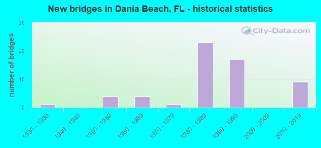
- New bridges - historical statistics
- 11930-1939
- 41950-1959
- 41960-1969
- 11970-1979
- 231980-1989
- 171990-1999
- 92010-2019

- Reconstructed bridges - Historical Statistics
- 11950-1959
- 01960-1969
- 01970-1979
- 21980-1989
- 11990-1999
- 22000-2009


- Bridge Condition - Deck
- 3.8%Excellent
- 7.7%Very good
- 69.2%Good
- 7.7%Satisfactory
- 11.5%Fair

- Bridge Condition - Superstructure
- 3.8%Excellent
- 11.5%Very good
- 57.7%Good
- 11.5%Satisfactory
- 15.4%Fair

- Bridge Condition - Substructure
- 3.8%Excellent
- 19.2%Very good
- 57.7%Good
- 7.7%Satisfactory
- 7.7%Fair
- 3.8%Poor

- Bridge Condition - Channel
- 6.3%Excellent
- 12.5%Very good
- 56.3%Good
- 25.0%Satisfactory
Find on map >> Show street view
Structure Number: 860001, Location: 2.2mi. S of SR-84 (Lat: 26.059639, Lng: -80.143978), Route carried "on" structure: US 1, Year Built: 1931, Year Reconstructed: 1963, Status: Open, Structure Length: 3.11m (10.20ft), Average Daily Traffic: 40,500 (year 2020), Truck Traffic: 5%, Average Future Daily Traffic: 70,268 (year 2042), Design Load: HS 20, Features Intersected: Dania Canal
Minimum Vertical Clearance: 30+ m (98+ ft), Kilometerpoint: 9.522, Lanes on structure: 4, Base Highway Network: Yes, Owner: State Highway Agency, Approaching Roadway Width: 18.8m (61.7ft), Navigation Control: Yes ( Vertical Clearance: 3.5m (11.5ft), Horizontal Clearance: 8.8m (28.9ft)), Material/Design: Concrete, Design/Construction: Tee Beam, Number Of Spans In Main Unit: 3, Length of Maximum Span: 10.4m (34.1ft), Curb or Sidewalk Widths: Left: 1.5m (4.9ft), Right: 1.5m (4.9ft), Curb-To-Curb Width: 19.4m (63.6ft), Out-to-Out Width: 22.0m (72.2ft)
Condition: Deck: Fair, Superstructure: Fair, Substructure: Satisfactory, Channel: Satisfactory, Operating Rating: 46.4 metric tons, Method Used To Determine Operating Rating: Load Factor (LF), Inventory Rating: 27.8 metric tons, Method Used To Determine Inventory Rating: Load Factor (LF), Structural Evaluation: Somewhat better than minimum adequacy, Deck Geometry: Better than present minimum criteria, Waterway Adequacy: Superior to present desirable criteria, Approach Roadway Alignment: Better than present minimum criteria, Designated Inspection Frequency: Every 24 months, Underwater Inspection Frequency: Every 24 months, Inspection Date: June 2020, Underwater Inspection Date: June 2020, Deck Structure Type: Concrete Cast-file-Place, Wearing Surface/Protective System: Wearing Surface: Bituminous
Find on map >> Show street view
Structure Number: 860109, Location: 1.5mi South of SR-84 (Lat: 26.068167, Lng: -80.165694), Route carried "on" structure: Interstate 95, Year Built: 1965, Year Reconstructed: 1989, Status: Open, Structure Length: 5.50m (18.04ft), Average Daily Traffic: 100,750 (year 2020), Truck Traffic: 8%, Average Future Daily Traffic: 174,801 (year 2042), Design Load: HL 93, Features Intersected: Dania Cut-Off Canal
Minimum Vertical Clearance: 30+ m (98+ ft), Kilometerpoint: 10.527, Lanes on structure: 4, Base Highway Network: Yes, Owner: State Highway Agency, Approaching Roadway Width: 26.1m (85.6ft), Skew: 1 degrees, Navigation Control: Yes ( Vertical Clearance: 3.4m (11.2ft), Horizontal Clearance: 18.3m (60.0ft)), Material/Design: Prestressed concrete, Design/Construction: Stringer/Multi-beam, Number Of Spans In Main Unit: 3, Length of Maximum Span: 24.4m (80.1ft), Curb-To-Curb Width: 26.1m (85.6ft), Out-to-Out Width: 27.0m (88.6ft)
Condition: Deck: Good, Superstructure: Good, Substructure: Good, Channel: Good, Operating Rating: 38.2 metric tons, Method Used To Determine Operating Rating: Load and Resistance Factor (LRFR), Inventory Rating: 29.4 metric tons, Method Used To Determine Inventory Rating: Load and Resistance Factor (LRFR), Structural Evaluation: Better than present minimum criteria, Deck Geometry: Superior to present desirable criteria, Waterway Adequacy: Superior to present desirable criteria, Approach Roadway Alignment: Equal to present desirable criteria, Designated Inspection Frequency: Every 24 months, Underwater Inspection Frequency: Every 24 months, Inspection Date: Febuary 2022, Underwater Inspection Date: Febuary 2022, Deck Structure Type: Concrete Cast-file-Place
Find on map >> Show street view
Structure Number: 86016, Location: Mizell-Eula Johnson Park (Lat: 26.055772, Lng: -80.114028), Route carried "on" structure: County highway , Year Built: 1965, Status: Open, Structure Length: 5.79m (19.00ft), Average Daily Traffic: 5,333 (year 2019), Truck Traffic: 5%, Average Future Daily Traffic: 9,253 (year 2041), Design Load: HS 20, Features Intersected: New River Sound, Facility Carried by Structure: North Ocean Drive
Minimum Vertical Clearance: 30+ m (98+ ft), Kilometerpoint: 0.132, Lanes on structure: 2, Owner: State Park, Forest, or Reservation Agency, Approaching Roadway Width: 8.7m (28.5ft), Navigation Control: Yes ( Vertical Clearance: 5.5m (18.0ft), Horizontal Clearance: 12.2m (40.0ft)), Material/Design: Prestressed concrete, Design/Construction: Stringer/Multi-beam, Number Of Spans In Main Unit: 4, Length of Maximum Span: 16.3m (53.5ft), Curb or Sidewalk Widths: Left: 0.5m (1.6ft), Right: 1.4m (4.6ft), Curb-To-Curb Width: 8.5m (27.9ft), Out-to-Out Width: 11.3m (37.1ft)
Condition: Deck: Good, Superstructure: Fair, Substructure: Poor, Channel: Good, Operating Rating: 75.3 metric tons, Method Used To Determine Operating Rating: Load Factor (LF), Inventory Rating: 45.2 metric tons, Method Used To Determine Inventory Rating: Load Factor (LF), Structural Evaluation: Meets minimum limits, Deck Geometry: High priority of replacement, Waterway Adequacy: Better than present minimum criteria, Approach Roadway Alignment: Equal to present desirable criteria, Designated Inspection Frequency: Every 24 months, Underwater Inspection Frequency: Every 24 months, Other Special Inspection Frequency: Every 2 months, Inspection Date: April 2021, Underwater Inspection Date: April 2021, Other Special Inspection Date: Febuary 2022, Deck Structure Type: Concrete Cast-file-Place, Wearing Surface/Protective System: Wearing Surface: Bituminous
Find on map >> Show street view
Structure Number: 860161, Location: Mizell-Eula Johnson Park (Lat: 26.081436, Lng: -80.111389), Route carried "on" structure: State lands road , Year Built: 1965, Status: Open, Structure Length: 2.74m (8.99ft), Average Daily Traffic: 1,566 (year 2019), Truck Traffic: 5%, Average Future Daily Traffic: 2,717 (year 2041), Design Load: HS 20, Features Intersected: Florida East Coast Canal, Facility Carried by Structure: North Ocean Drive
Minimum Vertical Clearance: 30+ m (98+ ft), Kilometerpoint: 3.058, Lanes on structure: 2, Toll: On toll road, Owner: State Park, Forest, or Reservation Agency, Approaching Roadway Width: 7.5m (24.6ft), Navigation Control: Yes ( Vertical Clearance: 4.0m (13.1ft), Horizontal Clearance: 7.6m (24.9ft)), Material/Design: Prestressed concrete, Design/Construction: Slab, Number Of Spans In Main Unit: 3, Length of Maximum Span: 9.8m (32.2ft), Curb or Sidewalk Widths: Left: 0.5m (1.6ft), Right: 1.4m (4.6ft), Curb-To-Curb Width: 8.5m (27.9ft), Out-to-Out Width: 11.3m (37.1ft)
Condition: Deck: Fair, Superstructure: Fair, Substructure: Fair, Channel: Very good, Operating Rating: 54.8 metric tons, Method Used To Determine Operating Rating: Load Factor (LF), Inventory Rating: 32.9 metric tons, Method Used To Determine Inventory Rating: Load Factor (LF), Structural Evaluation: Somewhat better than minimum adequacy, Deck Geometry: Somewhat better than minimum adequacy, Waterway Adequacy: Superior to present desirable criteria, Approach Roadway Alignment: Equal to present desirable criteria, Designated Inspection Frequency: Every 24 months, Underwater Inspection Frequency: Every 24 months, Inspection Date: April 2021, Underwater Inspection Date: April 2021, Deck Structure Type: Concrete Precast Panels, Wearing Surface/Protective System: Wearing Surface: Bituminous
Find on map >> Show street view
Structure Number: 860209, Location: 1.5 Mi South of SR-84 (Lat: 26.068167, Lng: -80.165408), Route carried "on" structure: Interstate 95, Year Built: 1965, Year Reconstructed: 1989, Status: Open, Structure Length: 5.49m (18.01ft), Average Daily Traffic: 100,750 (year 2020), Truck Traffic: 8%, Average Future Daily Traffic: 174,801 (year 2042), Design Load: HL 93, Features Intersected: Dania Cut-Off Canal
Minimum Vertical Clearance: 30+ m (98+ ft), Kilometerpoint: 10.527, Lanes on structure: 5, Base Highway Network: Yes, Owner: State Highway Agency, Approaching Roadway Width: 25.3m (83.0ft), Skew: 1 degrees, Navigation Control: Yes ( Vertical Clearance: 3.4m (11.2ft), Horizontal Clearance: 18.3m (60.0ft)), Material/Design: Prestressed concrete, Design/Construction: Stringer/Multi-beam, Number Of Spans In Main Unit: 3, Length of Maximum Span: 24.4m (80.1ft), Curb-To-Curb Width: 28.7m (94.2ft), Out-to-Out Width: 29.4m (96.5ft)
Condition: Deck: Good, Superstructure: Good, Substructure: Good, Channel: Good, Operating Rating: 47.4 metric tons, Method Used To Determine Operating Rating: Load and Resistance Factor (LRFR), Inventory Rating: 36.6 metric tons, Method Used To Determine Inventory Rating: Load and Resistance Factor (LRFR), Structural Evaluation: Better than present minimum criteria, Deck Geometry: Superior to present desirable criteria, Waterway Adequacy: Superior to present desirable criteria, Approach Roadway Alignment: Equal to present desirable criteria, Designated Inspection Frequency: Every 24 months, Underwater Inspection Frequency: Every 24 months, Inspection Date: Febuary 2022, Underwater Inspection Date: Febuary 2022, Deck Structure Type: Concrete Cast-file-Place
Find on map >> Show street view
Structure Number: 860427, Location: 1mi W of I-95 (SR-9) (Lat: 26.084075, Lng: -80.183644), Route carried "on" structure: Interstate 595, Year Built: 1987, Status: Open, Structure Length: 146.63m (481.07ft), Average Daily Traffic: 97,250 (year 2020), Truck Traffic: 6%, Average Future Daily Traffic: 168,729 (year 2042), Design Load: HS 20, Features Intersected: SW26terr/New River/30AV
Minimum Vertical Clearance: 5.64m (18.50ft), Kilometerpoint: 14.574, Lanes on structure: 5, Lanes under structure: 8, Base Highway Network: Yes, Owner: State Highway Agency, Approaching Roadway Width: 17.1m (56.1ft), Navigation Control: Yes ( Vertical Clearance: 13.9m (45.6ft), Horizontal Clearance: 12.2m (40.0ft)), Material/Design: Prestressed concrete, Design/Construction: Stringer/Multi-beam, Number Of Spans In Main Unit: 51, Length of Maximum Span: 30.6m (100.4ft), Curb-To-Curb Width: 20.7m (67.9ft), Out-to-Out Width: 21.6m (70.9ft)
Condition: Deck: Good, Superstructure: Good, Substructure: Good, Channel: Good, Operating Rating: 58.1 metric tons, Method Used To Determine Operating Rating: Load Factor (LF), Inventory Rating: 34.8 metric tons, Method Used To Determine Inventory Rating: Load Factor (LF), Structural Evaluation: Better than present minimum criteria, Deck Geometry: Meets minimum limits, Underclear: High priority of corrective action, Waterway Adequacy: Superior to present desirable criteria, Approach Roadway Alignment: Equal to present desirable criteria, Designated Inspection Frequency: Every 24 months, Underwater Inspection Frequency: Every 24 months, Inspection Date: April 2020, Underwater Inspection Date: April 2020, Deck Structure Type: Concrete Cast-file-Place
Find on map >> Show street view
Structure Number: 860428, Location: 1Mi W of I-95 (SR-9) (Lat: 26.083806, Lng: -80.184667), Route carried "on" structure: Interstate 595, Year Built: 1987, Status: Open, Structure Length: 146.63m (481.07ft), Average Daily Traffic: 97,250 (year 2022), Truck Traffic: 6%, Average Future Daily Traffic: 168,729 (year 2042), Design Load: HS 20, Features Intersected: SW26Terr,New River,30Ave
Minimum Vertical Clearance: 5.99m (19.65ft), Kilometerpoint: 14.574, Lanes on structure: 5, Lanes under structure: 7, Base Highway Network: Yes, Owner: State Highway Agency, Approaching Roadway Width: 17.1m (56.1ft), Skew: 9 degrees, Navigation Control: Yes ( Vertical Clearance: 13.9m (45.6ft), Horizontal Clearance: 12.2m (40.0ft)), Material/Design: Prestressed concrete, Design/Construction: Stringer/Multi-beam, Number Of Spans In Main Unit: 51, Length of Maximum Span: 30.6m (100.4ft), Curb-To-Curb Width: 20.7m (67.9ft), Out-to-Out Width: 21.6m (70.9ft)
Condition: Deck: Good, Superstructure: Good, Substructure: Good, Channel: Good, Operating Rating: 58.5 metric tons, Method Used To Determine Operating Rating: Load Factor (LF), Inventory Rating: 35.1 metric tons, Method Used To Determine Inventory Rating: Load Factor (LF), Structural Evaluation: Better than present minimum criteria, Deck Geometry: Meets minimum limits, Underclear: High priority of corrective action, Waterway Adequacy: Superior to present desirable criteria, Approach Roadway Alignment: Equal to present desirable criteria, Designated Inspection Frequency: Every 24 months, Underwater Inspection Frequency: Every 24 months, Inspection Date: January 2022, Underwater Inspection Date: January 2022, Deck Structure Type: Concrete Cast-file-Place
Find on map >> Show street view
Structure Number: 860521, Location: SR-84 and I-95 (Lat: 26.087972, Lng: -80.169278), Route carried "on" structure: Ramp State highway 84, Year Built: 1989, Status: Open, Structure Length: 8.29m (27.20ft), Average Daily Traffic: 8,200 (year 2020), Truck Traffic: 8%, Average Future Daily Traffic: 14,227 (year 2042), Design Load: HS 20+Mod, Features Intersected: R/R & ramp to I-595
Minimum Vertical Clearance: 30+ m (98+ ft), Kilometerpoint: 0.362, Lanes on structure: 1, Lanes under structure: 4, Owner: State Highway Agency, Approaching Roadway Width: 8.2m (26.9ft), Skew: 1 degrees, Material/Design: Steel continuous, Design/Construction: Box Beam or Girders - Single/Spread, Number Of Spans In Main Unit: 3, Length of Maximum Span: 36.6m (120.1ft), Curb-To-Curb Width: 8.2m (26.9ft), Out-to-Out Width: 9.0m (29.5ft)
Condition: Deck: Good, Superstructure: Good, Substructure: Good, Operating Rating: 59.9 metric tons, Method Used To Determine Operating Rating: Load Factor (LF), Inventory Rating: 35.8 metric tons, Method Used To Determine Inventory Rating: Load Factor (LF), Structural Evaluation: Better than present minimum criteria, Deck Geometry: Superior to present desirable criteria, Underclear: Equal to present desirable criteria, Approach Roadway Alignment: Equal to present desirable criteria, Designated Inspection Frequency: Every 24 months, Critical Feature Inspection Frequency: Every 24 months, Inspection Date: December 2021, Critical Feature Inspection Date: December 2021, Deck Structure Type: Concrete Cast-file-Place
Find on map >> Show street view
Structure Number: 860538, Location: I-595 & I-95 Interchange (Lat: 26.083222, Lng: -80.170444), Route carried "on" structure: Ramp Interstate 595, Year Built: 1990, Status: Open, Structure Length: 123.61m (405.54ft), Average Daily Traffic: 40,000 (year 2022), Truck Traffic: 10%, Average Future Daily Traffic: 69,400 (year 2042), Design Load: HS 20+Mod, Features Intersected: I-595 SW conn. NE conn.
Minimum Vertical Clearance: 30+ m (98+ ft), Kilometerpoint: 0.016, Lanes on structure: 2, Lanes under structure: 27, Owner: State Highway Agency, Approaching Roadway Width: 12.2m (40.0ft), Material/Design: Steel continuous, Design/Construction: Box Beam or Girders - Single/Spread, Number Of Spans In Main Unit: 21, Number Of Approach Spans: 4, Length of Maximum Span: 64.3m (211.0ft), Curb-To-Curb Width: 12.1m (39.7ft), Out-to-Out Width: 13.0m (42.7ft)
Condition: Deck: Good, Superstructure: Good, Substructure: Good, Operating Rating: 54.4 metric tons, Method Used To Determine Operating Rating: Load Factor (LF), Inventory Rating: 32.7 metric tons, Method Used To Determine Inventory Rating: Load Factor (LF), Structural Evaluation: Better than present minimum criteria, Deck Geometry: Superior to present desirable criteria, Underclear: Meets minimum limits, Approach Roadway Alignment: Equal to present desirable criteria, Designated Inspection Frequency: Every 24 months, Critical Feature Inspection Frequency: Every 24 months, Inspection Date: January 2022, Critical Feature Inspection Date: January 2022, Deck Structure Type: Concrete Cast-file-Place, Wearing Surface/Protective System: Wearing Surface: Epoxy Overlay
Find on map >> Show street view
Structure Number: 860541, Location: I-95/I-595 Interchange (Lat: 26.082361, Lng: -80.168917), Route carried "on" structure: Ramp Interstate 595, Year Built: 1990, Status: Open, Structure Length: 49.96m (163.91ft), Average Daily Traffic: 27,500 (year 2020), Truck Traffic: 10%, Average Future Daily Traffic: 47,712 (year 2042), Design Load: HS 20+Mod, Features Intersected: I-95,I-595, & RR
Minimum Vertical Clearance: 7.38m (24.21ft), Kilometerpoint: 0.649, Lanes on structure: 2, Lanes under structure: 10, Owner: State Highway Agency, Approaching Roadway Width: 12.2m (40.0ft), Skew: 9 degrees, Material/Design: Steel continuous, Design/Construction: Box Beam or Girders - Single/Spread, Number Of Spans In Main Unit: 10, Length of Maximum Span: 62.9m (206.4ft), Curb-To-Curb Width: 12.2m (40.0ft), Out-to-Out Width: 13.0m (42.7ft)
Condition: Deck: Good, Superstructure: Satisfactory, Substructure: Good, Operating Rating: 57.2 metric tons, Method Used To Determine Operating Rating: Load Testing, Inventory Rating: 34.3 metric tons, Method Used To Determine Inventory Rating: Load Testing, Structural Evaluation: Equal to present minimum criteria, Deck Geometry: Superior to present desirable criteria, Underclear: Meets minimum limits, Approach Roadway Alignment: Equal to present desirable criteria, Designated Inspection Frequency: Every 24 months, Critical Feature Inspection Frequency: Every 24 months, Inspection Date: January 2022, Critical Feature Inspection Date: January 2022, Deck Structure Type: Concrete Cast-file-Place
Find on map >> Show street view
Structure Number: 860546, Location: .3mi North of Griffin Rd (Lat: 26.068167, Lng: -80.165972), Route carried "on" structure: Ramp Interstate 95, Year Built: 1988, Status: Open, Structure Length: 5.50m (18.04ft), Average Daily Traffic: 9,400 (year 2020), Truck Traffic: 6%, Average Future Daily Traffic: 16,309 (year 2042), Design Load: HS 20, Features Intersected: C-11 Dania Cut-Off Canal
Minimum Vertical Clearance: 30+ m (98+ ft), Kilometerpoint: 0.816, Lanes on structure: 2, Owner: State Highway Agency, Approaching Roadway Width: 12.2m (40.0ft), Skew: 1 degrees, Navigation Control: Yes ( Vertical Clearance: 3.4m (11.2ft), Horizontal Clearance: 18.3m (60.0ft)), Material/Design: Prestressed concrete, Design/Construction: Stringer/Multi-beam, Number Of Spans In Main Unit: 3, Length of Maximum Span: 24.4m (80.1ft), Curb-To-Curb Width: 12.2m (40.0ft), Out-to-Out Width: 13.0m (42.7ft)
Condition: Deck: Good, Superstructure: Good, Substructure: Good, Channel: Good, Operating Rating: 56.4 metric tons, Method Used To Determine Operating Rating: Load Factor (LF), Inventory Rating: 45.8 metric tons, Method Used To Determine Inventory Rating: Load Factor (LF), Structural Evaluation: Better than present minimum criteria, Deck Geometry: Superior to present desirable criteria, Waterway Adequacy: Superior to present desirable criteria, Approach Roadway Alignment: Equal to present desirable criteria, Designated Inspection Frequency: Every 24 months, Underwater Inspection Frequency: Every 24 months, Inspection Date: Febuary 2022, Underwater Inspection Date: Febuary 2022, Deck Structure Type: Concrete Cast-file-Place
Find on map >> Show street view
Structure Number: 860547, Location: I95/I595 interchange (Lat: 26.073133, Lng: -80.168006), Route carried "on" structure: Ramp Interstate 95, Year Built: 1988, Status: Open, Structure Length: 11.85m (38.88ft), Average Daily Traffic: 9,400 (year 2020), Truck Traffic: 6%, Average Future Daily Traffic: 16,309 (year 2042), Design Load: HS 20, Features Intersected: I-595 to SB I-95 Ramp
Minimum Vertical Clearance: 30+ m (98+ ft), Kilometerpoint: 0.188, Lanes on structure: 1, Lanes under structure: 3, Owner: State Highway Agency, Approaching Roadway Width: 8.2m (26.9ft), Material/Design: Steel continuous, Design/Construction: Box Beam or Girders - Single/Spread, Number Of Spans In Main Unit: 3, Length of Maximum Span: 56.0m (183.7ft), Curb-To-Curb Width: 8.2m (26.9ft), Out-to-Out Width: 9.1m (29.9ft)
Condition: Deck: Good, Superstructure: Good, Substructure: Very good, Operating Rating: 62.4 metric tons, Method Used To Determine Operating Rating: Load Factor (LF), Inventory Rating: 37.2 metric tons, Method Used To Determine Inventory Rating: Load Factor (LF), Structural Evaluation: Better than present minimum criteria, Deck Geometry: Superior to present desirable criteria, Underclear: Somewhat better than minimum adequacy, Approach Roadway Alignment: Equal to present desirable criteria, Designated Inspection Frequency: Every 24 months, Critical Feature Inspection Frequency: Every 24 months, Inspection Date: Febuary 2022, Critical Feature Inspection Date: Febuary 2022, Deck Structure Type: Concrete Cast-file-Place
Find on map >> Show street view
Structure Number: 860548, Location: .6 Mi North of Griffin Rd (Lat: 26.070253, Lng: -80.166464), Route carried "on" structure: City street , Year Built: 1989, Status: Open, Structure Length: 11.17m (36.65ft), Average Daily Traffic: 5,600 (year 2020), Truck Traffic: 9%, Average Future Daily Traffic: 9,716 (year 2042), Design Load: HS 20, Features Intersected: I-95, Ramps & CSX RR, Facility Carried by Structure: SW 42nd Street
Minimum Vertical Clearance: 30+ m (98+ ft), Kilometerpoint: 1.569, Lanes on structure: 2, Lanes under structure: 16, Owner: State Highway Agency, Approaching Roadway Width: 9.8m (32.2ft), Material/Design: Steel continuous, Design/Construction: Stringer/Multi-beam, Number Of Spans In Main Unit: 2, Length of Maximum Span: 61.6m (202.1ft), Curb-To-Curb Width: 11.0m (36.1ft), Out-to-Out Width: 11.8m (38.7ft)
Condition: Deck: Good, Superstructure: Very good, Substructure: Very good, Operating Rating: 72.3 metric tons, Method Used To Determine Operating Rating: Load Factor (LF), Inventory Rating: 43.4 metric tons, Method Used To Determine Inventory Rating: Load Factor (LF), Structural Evaluation: Equal to present desirable criteria, Deck Geometry: Meets minimum limits, Underclear: Meets minimum limits, Approach Roadway Alignment: Equal to present desirable criteria, Designated Inspection Frequency: Every 24 months, Inspection Date: October 2021, Deck Structure Type: Concrete Cast-file-Place
Find on map >> Show street view
Structure Number: 860554, Location: 1.25 Miles South of I-595 (Lat: 26.062750, Lng: -80.164139), Route carried "on" structure: Interstate 95, Year Built: 1990, Status: Open, Structure Length: 5.49m (18.01ft), Average Daily Traffic: 108,500 (year 2020), Truck Traffic: 8%, Average Future Daily Traffic: 188,248 (year 2042), Design Load: HS 20+Mod, Features Intersected: SR-818 (Griffin Road)
Minimum Vertical Clearance: 30+ m (98+ ft), Kilometerpoint: 9.910, Lanes on structure: 5, Lanes under structure: 10, Base Highway Network: Yes, Owner: State Highway Agency, Approaching Roadway Width: 26.3m (86.3ft), Skew: 1 degrees, Material/Design: Prestressed concrete, Design/Construction: Stringer/Multi-beam, Number Of Spans In Main Unit: 2, Length of Maximum Span: 27.4m (89.9ft), Curb-To-Curb Width: 25.3m (83.0ft), Out-to-Out Width: 26.1m (85.6ft)
Condition: Deck: Good, Superstructure: Good, Substructure: Good, Operating Rating: 53.5 metric tons, Method Used To Determine Operating Rating: Load and Resistance Factor (LRFR), Inventory Rating: 45.4 metric tons, Method Used To Determine Inventory Rating: Load and Resistance Factor (LRFR), Structural Evaluation: Better than present minimum criteria, Deck Geometry: Better than present minimum criteria, Underclear: Equal to present minimum criteria, Approach Roadway Alignment: Equal to present desirable criteria, Designated Inspection Frequency: Every 24 months, Inspection Date: December 2021, Deck Structure Type: Concrete Cast-file-Place
Find on map >> Show street view
Structure Number: 860555, Location: 1.25mi S of I-595 (Lat: 26.062772, Lng: -80.163867), Route carried "on" structure: Interstate 95, Year Built: 1989, Status: Open, Structure Length: 5.49m (18.01ft), Average Daily Traffic: 108,500 (year 2020), Truck Traffic: 8%, Average Future Daily Traffic: 188,248 (year 2042), Design Load: HS 20+Mod, Features Intersected: SR-818 (Griffin Rd.)
Minimum Vertical Clearance: 30+ m (98+ ft), Kilometerpoint: 9.910, Lanes on structure: 5, Lanes under structure: 10, Base Highway Network: Yes, Owner: State Highway Agency, Approaching Roadway Width: 26.3m (86.3ft), Skew: 1 degrees, Material/Design: Prestressed concrete, Design/Construction: Stringer/Multi-beam, Number Of Spans In Main Unit: 2, Length of Maximum Span: 27.4m (89.9ft), Curb-To-Curb Width: 25.3m (83.0ft), Out-to-Out Width: 26.1m (85.6ft)
Condition: Deck: Very good, Superstructure: Very good, Substructure: Good, Operating Rating: 53.5 metric tons, Method Used To Determine Operating Rating: Load and Resistance Factor (LRFR), Inventory Rating: 45.4 metric tons, Method Used To Determine Inventory Rating: Load and Resistance Factor (LRFR), Structural Evaluation: Better than present minimum criteria, Deck Geometry: Better than present minimum criteria, Underclear: Equal to present minimum criteria, Approach Roadway Alignment: Equal to present desirable criteria, Designated Inspection Frequency: Every 24 months, Inspection Date: December 2021, Deck Structure Type: Concrete Cast-file-Place
Find on map >> Show street view
Structure Number: 860579, Location: I-95 over Stirling Road (Lat: 26.048167, Lng: -80.162472), Route carried "on" structure: Interstate 95, Year Built: 1990, Year Reconstructed: 2014, Status: Open, Structure Length: 5.43m (17.81ft), Average Daily Traffic: 109,000 (year 2020), Truck Traffic: 8%, Average Future Daily Traffic: 189,115 (year 2042), Design Load: HL 93, Features Intersected: SR-848 Stirling Rd.
Minimum Vertical Clearance: 30+ m (98+ ft), Kilometerpoint: 8.278, Lanes on structure: 5, Lanes under structure: 10, Base Highway Network: Yes, Owner: State Highway Agency, Approaching Roadway Width: 25.4m (83.3ft), Material/Design: Prestressed concrete, Design/Construction: Stringer/Multi-beam, Number Of Spans In Main Unit: 2, Length of Maximum Span: 27.1m (88.9ft), Curb-To-Curb Width: 28.0m (91.9ft), Out-to-Out Width: 29.0m (95.1ft)
Condition: Deck: Good, Superstructure: Very good, Substructure: Very good, Operating Rating: 47.7 metric tons, Method Used To Determine Operating Rating: Load and Resistance Factor (LRFR), Inventory Rating: 34.3 metric tons, Method Used To Determine Inventory Rating: Load and Resistance Factor (LRFR), Structural Evaluation: Equal to present desirable criteria, Deck Geometry: Superior to present desirable criteria, Underclear: Equal to present minimum criteria, Approach Roadway Alignment: Equal to present desirable criteria, Designated Inspection Frequency: Every 24 months, Inspection Date: May 2021, Deck Structure Type: Concrete Cast-file-Place
Find on map >> Show street view
Structure Number: 86058, Location: I-95 over Stirling Road (Lat: 26.048167, Lng: -80.162167), Route carried "on" structure: Interstate 95, Year Built: 1990, Year Reconstructed: 2014, Status: Open, Structure Length: 5.43m (17.81ft), Average Daily Traffic: 109,000 (year 2020), Truck Traffic: 8%, Average Future Daily Traffic: 189,115 (year 2042), Design Load: HL 93, Features Intersected: SR-848 Stirling Rd.
Minimum Vertical Clearance: 30+ m (98+ ft), Kilometerpoint: 8.278, Lanes on structure: 5, Lanes under structure: 10, Base Highway Network: Yes, Owner: State Highway Agency, Approaching Roadway Width: 25.6m (84.0ft), Material/Design: Prestressed concrete, Design/Construction: Stringer/Multi-beam, Number Of Spans In Main Unit: 2, Length of Maximum Span: 27.1m (88.9ft), Curb-To-Curb Width: 28.0m (91.9ft), Out-to-Out Width: 29.0m (95.1ft)
Condition: Deck: Good, Superstructure: Good, Substructure: Very good, Operating Rating: 47.7 metric tons, Method Used To Determine Operating Rating: Load and Resistance Factor (LRFR), Inventory Rating: 34.3 metric tons, Method Used To Determine Inventory Rating: Load and Resistance Factor (LRFR), Structural Evaluation: Better than present minimum criteria, Deck Geometry: Superior to present desirable criteria, Underclear: Equal to present minimum criteria, Approach Roadway Alignment: Equal to present desirable criteria, Designated Inspection Frequency: Every 24 months, Inspection Date: May 2021, Deck Structure Type: Concrete Cast-file-Place
Find on map >> Show street view
Structure Number: 860591, Location: 0.25 mi. East of I-95 (Lat: 26.048164, Lng: -80.155289), Route carried "on" structure: State highway 848, Year Built: 1982, Status: Open, Structure Length: 3.41m (11.19ft), Average Daily Traffic: 18,500 (year 2021), Truck Traffic: 4%, Average Future Daily Traffic: 32,098 (year 2042), Design Load: HS 20, Features Intersected: C-10 Canal
Minimum Vertical Clearance: 30+ m (98+ ft), Kilometerpoint: 9.654, Lanes on structure: 6, Base Highway Network: Yes, Owner: State Highway Agency, Approaching Roadway Width: 27.7m (90.9ft), Skew: 20 degrees, Navigation Control: Yes ( Vertical Clearance: 2.1m (6.9ft), Horizontal Clearance: 10.4m (34.1ft)), Material/Design: Prestressed concrete, Design/Construction: Slab, Number Of Spans In Main Unit: 3, Length of Maximum Span: 11.4m (37.4ft), Curb or Sidewalk Widths: Left: 1.5m (4.9ft), Right: 1.5m (4.9ft), Curb-To-Curb Width: 27.7m (90.9ft), Out-to-Out Width: 31.6m (103.7ft)
Condition: Deck: Fair, Superstructure: Fair, Substructure: Satisfactory, Channel: Very good, Operating Rating: 62.3 metric tons, Method Used To Determine Operating Rating: Load Factor (LF), Inventory Rating: 37.4 metric tons, Method Used To Determine Inventory Rating: Load Factor (LF), Structural Evaluation: Somewhat better than minimum adequacy, Deck Geometry: Equal to present desirable criteria, Waterway Adequacy: Superior to present desirable criteria, Approach Roadway Alignment: Equal to present desirable criteria, Designated Inspection Frequency: Every 24 months, Underwater Inspection Frequency: Every 24 months, Inspection Date: March 2021, Underwater Inspection Date: March 2021, Deck Structure Type: Concrete Precast Panels, Wearing Surface/Protective System: Wearing Surface: Bituminous
Find on map >> Show street view
Structure Number: 860592, Location: 0.25mi. East of I-95 (Lat: 26.063083, Lng: -80.159156), Route carried "on" structure: State highway 818, Year Built: 1984, Status: Open, Structure Length: 10.24m (33.60ft), Average Daily Traffic: 18,700 (year 2020), Truck Traffic: 5%, Average Future Daily Traffic: 32,444 (year 2042), Design Load: HS 20+Mod, Features Intersected: Dania Cut-Off Canal, Facility Carried by Structure: New Griffin Rd.
Minimum Vertical Clearance: 30+ m (98+ ft), Kilometerpoint: 15.561, Lanes on structure: 6, Lanes under structure: 2, Base Highway Network: Yes, Owner: State Highway Agency, Approaching Roadway Width: 26.0m (85.3ft), Skew: 22 degrees, Navigation Control: Yes ( Vertical Clearance: 5.4m (17.7ft), Horizontal Clearance: 23.5m (77.1ft)), Material/Design: Prestressed concrete, Design/Construction: Stringer/Multi-beam, Number Of Spans In Main Unit: 5, Length of Maximum Span: 24.4m (80.1ft), Curb or Sidewalk Widths: Left: 1.5m (4.9ft), Right: 1.5m (4.9ft), Curb-To-Curb Width: 26.0m (85.3ft), Out-to-Out Width: 30.0m (98.4ft)
Condition: Deck: Satisfactory, Superstructure: Good, Substructure: Good, Channel: Good, Operating Rating: 42.8 metric tons, Method Used To Determine Operating Rating: Load and Resistance Factor (LRFR), Inventory Rating: 32.7 metric tons, Method Used To Determine Inventory Rating: Load and Resistance Factor (LRFR), Structural Evaluation: Better than present minimum criteria, Deck Geometry: Equal to present minimum criteria, Underclear: Somewhat better than minimum adequacy, Waterway Adequacy: Superior to present desirable criteria, Approach Roadway Alignment: Equal to present desirable criteria, Designated Inspection Frequency: Every 24 months, Underwater Inspection Frequency: Every 24 months, Inspection Date: May 2021, Underwater Inspection Date: May 2021, Deck Structure Type: Concrete Precast Panels
Find on map >> Show street view
Structure Number: 86061, Location: 1 mi west of I-95 on SR84 (Lat: 26.085714, Lng: -80.181869), Route carried "on" structure: State highway 84, Year Built: 1956, Status: Open, Structure Length: 0.78m (2.56ft), Average Daily Traffic: 36,000 (year 2022), Truck Traffic: 10%, Average Future Daily Traffic: 62,460 (year 2042), Design Load: H 20, Features Intersected: DRAINAGE CANAL
Minimum Vertical Clearance: 30+ m (98+ ft), Kilometerpoint: 27.077, Lanes on structure: 5, Owner: State Highway Agency, Approaching Roadway Width: 14.6m (47.9ft), Skew: 10 degrees, Material/Design: Concrete continuous, Design/Construction: Slab, Number Of Spans In Main Unit: 2, Length of Maximum Span: 3.9m (12.8ft), Curb or Sidewalk Widths: Left: 2.7m (8.9ft), Right: 0.0m, Curb-To-Curb Width: 21.5m (70.5ft), Out-to-Out Width: 61.4m (201.4ft)
Condition: Deck: Good, Superstructure: Good, Substructure: Good, Channel: Satisfactory, Operating Rating: 54.4 metric tons, Method Used To Determine Operating Rating: Load Testing, Inventory Rating: 32.7 metric tons, Method Used To Determine Inventory Rating: Load Testing, Structural Evaluation: Better than present minimum criteria, Deck Geometry: Somewhat better than minimum adequacy, Waterway Adequacy: Equal to present desirable criteria, Approach Roadway Alignment: Equal to present desirable criteria, Designated Inspection Frequency: Every 24 months, Underwater Inspection Frequency: Every 24 months, Inspection Date: January 2022, Underwater Inspection Date: January 2022, Deck Structure Type: Concrete Cast-file-Place
Find on map >> Show street view
Structure Number: 860646, Location: I-595 & Port Everglades (Lat: 26.080250, Lng: -80.131100), Route carried "on" structure: Ramp US 595, Year Built: 2012, Status: Open, Structure Length: 2.80m (9.19ft), Average Daily Traffic: 500 (year 2020), Truck Traffic: 3%, Average Future Daily Traffic: 868 (year 2042), Design Load: HL 93, Features Intersected: I-595 EB Ramp to 7th Ave, Facility Carried by Structure: US1 NB to Port Eve
Minimum Vertical Clearance: 30+ m (98+ ft), Kilometerpoint: 0.391, Lanes on structure: 1, Lanes under structure: 2, Owner: State Highway Agency, Approaching Roadway Width: 8.2m (26.9ft), Material/Design: Prestressed concrete, Design/Construction: Stringer/Multi-beam, Number Of Spans In Main Unit: 1, Length of Maximum Span: 28.0m (91.9ft), Curb-To-Curb Width: 8.2m (26.9ft), Out-to-Out Width: 9.2m (30.2ft)
Condition: Deck: Very good, Superstructure: Good, Substructure: Very good, Operating Rating: 45.1 metric tons, Method Used To Determine Operating Rating: Load and Resistance Factor (LRFR), Inventory Rating: 41.8 metric tons, Method Used To Determine Inventory Rating: Load and Resistance Factor (LRFR), Structural Evaluation: Better than present minimum criteria, Deck Geometry: Superior to present desirable criteria, Underclear: Somewhat better than minimum adequacy, Approach Roadway Alignment: Equal to present desirable criteria, Designated Inspection Frequency: Every 24 months, Inspection Date: November 2020, Deck Structure Type: Concrete Cast-file-Place
Find on map >> Show street view
Structure Number: 86092, Location: 1 mi. North SR-822 on A1A (Lat: 26.053039, Lng: -80.115586), Route carried "on" structure: State highway A1A, Year Built: 1956, Status: Open, Structure Length: 15.09m (49.51ft), Average Daily Traffic: 8,900 (year 2021), Truck Traffic: 3%, Average Future Daily Traffic: 15,442 (year 2042), Design Load: H 15, Features Intersected: Intracoastal Waterway, Facility Carried by Structure: Dania Bch. Blvd.
Minimum Vertical Clearance: 6.43m (21.10ft), Kilometerpoint: 9.022, Lanes on structure: 4, Lanes under structure: 4, Owner: State Highway Agency, Approaching Roadway Width: 13.4m (44.0ft), Skew: 20 degrees, Navigation Control: Yes ( Vertical Clearance: 6.7m (22.0ft), Horizontal Clearance: 27.7m (90.9ft)), Material/Design: Steel, Design/Construction: Movable - Bascule, Number Of Spans In Main Unit: 1, Number Of Approach Spans: 6, Length of Maximum Span: 43.0m (141.1ft), Curb or Sidewalk Widths: Left: 1.5m (4.9ft), Right: 1.8m (5.9ft), Curb-To-Curb Width: 14.0m (45.9ft), Out-to-Out Width: 17.9m (58.7ft)
Condition: Deck: Good, Superstructure: Satisfactory, Substructure: Good, Channel: Satisfactory, Operating Rating: 42.7 metric tons, Method Used To Determine Operating Rating: Load Testing, Inventory Rating: 25.7 metric tons, Method Used To Determine Inventory Rating: Load Testing, Structural Evaluation: Equal to present minimum criteria, Deck Geometry: High priority of replacement, Underclear: Meets minimum limits, Waterway Adequacy: Superior to present desirable criteria, Approach Roadway Alignment: Better than present minimum criteria, Designated Inspection Frequency: Every 24 months, Critical Feature Inspection Frequency: Every 24 months, Underwater Inspection Frequency: Every 24 months, Other Special Inspection Frequency: Every 12 months, Inspection Date: July 2021, Critical Feature Inspection Date: July 2021, Underwater Inspection Date: July 2021, Other Special Inspection Date: July 2021, Deck Structure Type: Concrete Cast-file-Place
Find on map >> Show street view
Structure Number: 864031, Location: 0.1 MI E OF BRYAN RD. (Lat: 26.053831, Lng: -80.155050), Route carried "on" structure: City street , Year Built: 1958, Status: Open, Structure Length: 2.39m (7.84ft), Average Daily Traffic: 2,992 (year 2021), Truck Traffic: 2%, Average Future Daily Traffic: 4,981 (year 2042), Design Load: H 20, Features Intersected: C-10 CANAL, Facility Carried by Structure: NW 1 ST
Minimum Vertical Clearance: 30+ m (98+ ft), Kilometerpoint: 0.000, Lanes on structure: 2, Owner: City or Municipal Highway Agency, Approaching Roadway Width: 8.1m (26.6ft), Material/Design: Prestressed concrete, Design/Construction: Slab, Number Of Spans In Main Unit: 3, Length of Maximum Span: 8.1m (26.6ft), Curb or Sidewalk Widths: Left: 1.1m (3.6ft), Right: 1.1m (3.6ft), Curb-To-Curb Width: 8.5m (27.9ft), Out-to-Out Width: 12.3m (40.4ft)
Condition: Deck: Satisfactory, Superstructure: Satisfactory, Substructure: Fair, Channel: Good, Operating Rating: 29.8 metric tons, Method Used To Determine Operating Rating: Load and Resistance Factor (LRFR), Inventory Rating: 13.7 metric tons, Method Used To Determine Inventory Rating: Load and Resistance Factor (LRFR), Structural Evaluation: Meets minimum limits, Deck Geometry: Meets minimum limits, Waterway Adequacy: Equal to present desirable criteria, Approach Roadway Alignment: Equal to present minimum criteria, Designated Inspection Frequency: Every 24 months, Underwater Inspection Frequency: Every 24 months, Inspection Date: January 2021, Underwater Inspection Date: January 2021, Deck Structure Type: Concrete Precast Panels, Wearing Surface/Protective System: Wearing Surface: Bituminous
Find on map >> Show street view
Structure Number: 864032, Location: 0.6MI N OF STIRLING RD (Lat: 26.052747, Lng: -80.183825), Route carried "on" structure: City street , Year Built: 1970, Status: Open, Structure Length: 0.70m (2.30ft), Average Daily Traffic: 4,500 (year 2021), Truck Traffic: 2%, Average Future Daily Traffic: 7,808 (year 2042), Features Intersected: LAKE ESCOM CANAL, Facility Carried by Structure: LAKE SHORE DRIVE
Minimum Vertical Clearance: 30+ m (98+ ft), Kilometerpoint: 0.000, Lanes on structure: 2, Owner: City or Municipal Highway Agency, Approaching Roadway Width: 7.2m (23.6ft), Material/Design: Prestressed concrete, Design/Construction: Slab, Number Of Spans In Main Unit: 1, Length of Maximum Span: 7.0m (23.0ft), Curb-To-Curb Width: 11.9m (39.0ft), Out-to-Out Width: 12.6m (41.3ft)
Condition: Deck: Good, Superstructure: Good, Substructure: Good, Channel: Satisfactory, Operating Rating: 32.0 metric tons, Method Used To Determine Operating Rating: Load Factor (LF), Inventory Rating: 28.8 metric tons, Method Used To Determine Inventory Rating: Load Factor (LF), Structural Evaluation: Better than present minimum criteria, Deck Geometry: Somewhat better than minimum adequacy, Waterway Adequacy: Equal to present desirable criteria, Approach Roadway Alignment: Better than present minimum criteria, Designated Inspection Frequency: Every 24 months, Underwater Inspection Frequency: Every 24 months, Inspection Date: Febuary 2021, Underwater Inspection Date: Febuary 2021, Deck Structure Type: Concrete Precast Panels, Wearing Surface/Protective System: Wearing Surface: Bituminous
Find on map >> Show street view
Structure Number: 864073, Location: 0.7MI W of US-1 (Lat: 26.059303, Lng: -80.155078), Route carried "on" structure: County highway , Year Built: 1983, Year Reconstructed: 2002, Status: Open, Structure Length: 2.76m (9.06ft), Average Daily Traffic: 4,320 (year 2021), Truck Traffic: 2%, Average Future Daily Traffic: 5,184 (year 2042), Design Load: HS 20, Features Intersected: C-10 CANAL, Facility Carried by Structure: OLD GRIFFIN RD.
Minimum Vertical Clearance: 30+ m (98+ ft), Kilometerpoint: 0.647, Lanes on structure: 2, Owner: County Highway Agency, Approaching Roadway Width: 8.5m (27.9ft), Material/Design: Prestressed concrete, Design/Construction: Slab, Number Of Spans In Main Unit: 3, Length of Maximum Span: 9.2m (30.2ft), Curb or Sidewalk Widths: Left: 1.4m (4.6ft), Right: 1.4m (4.6ft), Curb-To-Curb Width: 8.5m (27.9ft), Out-to-Out Width: 12.2m (40.0ft)
Condition: Deck: Good, Superstructure: Good, Substructure: Good, Channel: Good, Inventory Rating: 64.2 metric tons, Method Used To Determine Inventory Rating: Load Factor (LF), Structural Evaluation: Better than present minimum criteria, Deck Geometry: Meets minimum limits, Waterway Adequacy: Better than present minimum criteria, Approach Roadway Alignment: Better than present minimum criteria, Designated Inspection Frequency: Every 24 months, Underwater Inspection Frequency: Every 24 months, Inspection Date: Febuary 2021, Underwater Inspection Date: Febuary 2021, Deck Structure Type: Concrete Precast Panels, Wearing Surface/Protective System: Wearing Surface: Bituminous
Find on map >> Show street view
Structure Number: 864127, Location: 0.35 Mi N of Griffin Rd. (Lat: 26.068081, Lng: -80.168622), Route carried "on" structure: County highway , Year Built: 2016, Status: Open, Structure Length: 5.33m (17.49ft), Average Daily Traffic: 15,500 (year 2021), Truck Traffic: 8%, Average Future Daily Traffic: 27,200 (year 2042), Design Load: HL 93, Features Intersected: Dania Cut-Off Canal, Facility Carried by Structure: Ravenwood Road
Minimum Vertical Clearance: 30+ m (98+ ft), Kilometerpoint: 2.234, Lanes on structure: 2, Owner: County Highway Agency, Approaching Roadway Width: 12.5m (41.0ft), Navigation Control: Yes ( Vertical Clearance: 4.6m (15.1ft), Horizontal Clearance: 18.3m (60.0ft)), Material/Design: Prestressed concrete, Design/Construction: Stringer/Multi-beam, Number Of Spans In Main Unit: 3, Length of Maximum Span: 24.4m (80.1ft), Curb or Sidewalk Widths: Left: 2.0m (6.6ft), Right: 0.0m, Curb-To-Curb Width: 12.5m (41.0ft), Out-to-Out Width: 13.3m (43.6ft)
Condition: Deck: Excellent, Superstructure: Excellent, Substructure: Excellent, Channel: Excellent, Operating Rating: 44.7 metric tons, Method Used To Determine Operating Rating: Load and Resistance Factor (LRFR), Inventory Rating: 34.7 metric tons, Method Used To Determine Inventory Rating: Load and Resistance Factor (LRFR), Structural Evaluation: Superior to present desirable criteria, Deck Geometry: Somewhat better than minimum adequacy, Waterway Adequacy: Superior to present desirable criteria, Approach Roadway Alignment: Equal to present desirable criteria, Designated Inspection Frequency: Every 24 months, Underwater Inspection Frequency: Every 24 months, Inspection Date: December 2021, Underwater Inspection Date: December 2021, Deck Structure Type: Concrete Cast-file-Place, Wearing Surface/Protective System: Wearing Surface: Bituminous
Find on map >> Show street view
Structure Number: 860427, Location: 1mi W of I-95 (SR-9) (Lat: 26.084075, Lng: -80.183644), Route carried "under" structure: City street , Year Built: 1987, Structure Length: 0. m, Average Daily Traffic: 5,100 (year 2020), Truck Traffic: 9%, Features Intersected: SW26terr/New River/30AV, Facility Carried by Structure: WB I-595 (SR-862)
Minimum Vertical Clearance: 5.10m (16.73ft), Kilometerpoint: 0.132, Lanes on structure: 5, Lanes under structure: 3, Material/Design: Prestressed concrete, Design/Construction: Stringer/Multi-beam, Length of Maximum Span: 30.6m (100.4ft)
Find on map >> Show street view
Structure Number: 860427, Location: 1mi W of I-95 (SR-9) (Lat: 26.084075, Lng: -80.183644), Route carried "under" structure: City street , Year Built: 1987, Structure Length: 0. m, Average Daily Traffic: 11,200 (year 2020), Truck Traffic: 9%, Features Intersected: SW26terr/New River/30AV, Facility Carried by Structure: WB I-595 (SR-862)
Minimum Vertical Clearance: 7.60m (24.93ft), Kilometerpoint: 2.382, Lanes on structure: 5, Lanes under structure: 5, Material/Design: Prestressed concrete, Design/Construction: Stringer/Multi-beam, Length of Maximum Span: 30.6m (100.4ft)
Find on map >> Show street view
Structure Number: 860428, Location: 1Mi W of I-95 (SR-9) (Lat: 26.083806, Lng: -80.184667), Route carried "under" structure: City street , Year Built: 1987, Structure Length: 0. m, Average Daily Traffic: 5,100 (year 2020), Truck Traffic: 9%, Features Intersected: SW26Terr,New River,30Ave, Facility Carried by Structure: EB I-595 (SR-862)
Minimum Vertical Clearance: 5.39m (17.68ft), Kilometerpoint: 0.098, Lanes on structure: 5, Lanes under structure: 2, Material/Design: Prestressed concrete, Design/Construction: Stringer/Multi-beam, Length of Maximum Span: 30.6m (100.4ft)
Find on map >> Show street view
Structure Number: 860428, Location: 1Mi W of I-95 (SR-9) (Lat: 26.083806, Lng: -80.184667), Route carried "under" structure: City street , Year Built: 1987, Structure Length: 0. m, Average Daily Traffic: 11,200 (year 2020), Truck Traffic: 9%, Features Intersected: SW26Terr,New River,30Ave, Facility Carried by Structure: EB I-595 (SR-862)
Minimum Vertical Clearance: 7.59m (24.90ft), Kilometerpoint: 2.361, Lanes on structure: 5, Lanes under structure: 5, Material/Design: Prestressed concrete, Design/Construction: Stringer/Multi-beam, Length of Maximum Span: 30.6m (100.4ft)
Find on map >> Show street view
Structure Number: 860521, Location: SR-84 and I-95 (Lat: 26.087972, Lng: -80.169278), Route carried "under" structure: Ramp Interstate 595, Year Built: 1989, Structure Length: 0. m, Average Daily Traffic: 9,500 (year 2020), Truck Traffic: 8%, Features Intersected: R/R & ramp to I-595, Facility Carried by Structure: EB SR84 to SB I-95
Minimum Vertical Clearance: 6.37m (20.90ft), Kilometerpoint: 2.781, Lanes on structure: 1, Lanes under structure: 3, Material/Design: Steel continuous, Design/Construction: Box Beam or Girders - Single/Spread, Length of Maximum Span: 36.6m (120.1ft)
Find on map >> Show street view
Structure Number: 860521, Location: SR-84 and I-95 (Lat: 26.087972, Lng: -80.169278), Route carried "under" structure: Ramp State highway 84, Year Built: 1989, Structure Length: 0. m, Average Daily Traffic: 2,000 (year 2018), Truck Traffic: 2%, Features Intersected: R/R & ramp to I-595
Minimum Vertical Clearance: 6.46m (21.19ft), Kilometerpoint: 0.177, Lanes on structure: 1, Lanes under structure: 1, Material/Design: Steel continuous, Design/Construction: Box Beam or Girders - Single/Spread, Length of Maximum Span: 36.6m (120.1ft)
Find on map >> Show street view
Structure Number: 860538, Location: I-595 & I-95 Interchange (Lat: 26.083222, Lng: -80.170444), Route carried "under" structure: Interstate 95, Year Built: 1990, Structure Length: 0. m, Average Daily Traffic: 163,000 (year 2022), Truck Traffic: 5%, Features Intersected: I-595 SW conn. NE conn.
Minimum Vertical Clearance: 10.67m (35.01ft), Kilometerpoint: 16.393, Lanes on structure: 2, Lanes under structure: 11, Material/Design: Steel continuous, Design/Construction: Box Beam or Girders - Single/Spread, Length of Maximum Span: 64.3m (211.0ft)
Find on map >> Show street view
Structure Number: 860538, Location: I-595 & I-95 Interchange (Lat: 26.083222, Lng: -80.170444), Route carried "under" structure: Ramp Interstate 595, Year Built: 1990, Structure Length: 0. m, Average Daily Traffic: 9,500 (year 2022), Truck Traffic: 8%, Features Intersected: I-595 SW conn. NE conn.
Minimum Vertical Clearance: 5.09m (16.70ft), Kilometerpoint: 3.206, Lanes on structure: 2, Lanes under structure: 2, Material/Design: Steel continuous, Design/Construction: Box Beam or Girders - Single/Spread, Length of Maximum Span: 64.3m (211.0ft)
Find on map >> Show street view
Structure Number: 860538, Location: I-595 & I-95 Interchange (Lat: 26.083222, Lng: -80.170444), Route carried "under" structure: Ramp Interstate 595, Year Built: 1990, Structure Length: 0. m, Average Daily Traffic: 27,500 (year 2022), Truck Traffic: 10%, Features Intersected: I-595 SW conn. NE conn.
Minimum Vertical Clearance: 7.59m (24.90ft), Kilometerpoint: 1.114, Lanes on structure: 2, Lanes under structure: 2, Material/Design: Steel continuous, Design/Construction: Box Beam or Girders - Single/Spread, Length of Maximum Span: 64.3m (211.0ft)
Find on map >> Show street view
Structure Number: 860538, Location: I-595 & I-95 Interchange (Lat: 26.083222, Lng: -80.170444), Route carried "under" structure: City street , Year Built: 1990, Structure Length: 0. m, Average Daily Traffic: 500 (year 2022), Truck Traffic: 5%, Features Intersected: I-595 SW conn. NE conn., Facility Carried by Structure: EBI-595 to NBI-95
Minimum Vertical Clearance: 4.95m (16.24ft), Kilometerpoint: 0.000, Lanes on structure: 2, Lanes under structure: 3, Material/Design: Steel continuous, Design/Construction: Box Beam or Girders - Single/Spread, Length of Maximum Span: 64.3m (211.0ft)
Find on map >> Show street view
Structure Number: 860538, Location: I-595 & I-95 Interchange (Lat: 26.083222, Lng: -80.170444), Route carried "under" structure: Interstate 595, Year Built: 1990, Structure Length: 0. m, Average Daily Traffic: 25,250 (year 2022), Truck Traffic: 7%, Features Intersected: I-595 SW conn. NE conn.
Minimum Vertical Clearance: 5.15m (16.90ft), Kilometerpoint: 16.393, Lanes on structure: 2, Lanes under structure: 7, Material/Design: Steel continuous, Design/Construction: Box Beam or Girders - Single/Spread, Length of Maximum Span: 64.3m (211.0ft)
Find on map >> Show street view
Structure Number: 860538, Location: I-595 & I-95 Interchange (Lat: 26.083222, Lng: -80.170444), Route carried "under" structure: Ramp Interstate 595, Year Built: 1990, Structure Length: 0. m, Average Daily Traffic: 15,500 (year 2022), Truck Traffic: 8%, Features Intersected: I-595 SW conn. NE conn.
Minimum Vertical Clearance: 6.22m (20.41ft), Kilometerpoint: 0.560, Lanes on structure: 2, Lanes under structure: 2, Material/Design: Steel continuous, Design/Construction: Box Beam or Girders - Single/Spread, Length of Maximum Span: 64.3m (211.0ft)
Find on map >> Show street view
Structure Number: 860541, Location: I-95/I-595 Interchange (Lat: 26.082361, Lng: -80.168917), Route carried "under" structure: Interstate 595, Year Built: 1990, Structure Length: 0. m, Average Daily Traffic: 25,250 (year 2020), Truck Traffic: 7%, Features Intersected: I-95,I-595, & RR
Minimum Vertical Clearance: 5.15m (16.90ft), Kilometerpoint: 16.736, Lanes on structure: 2, Lanes under structure: 5, Material/Design: Steel continuous, Design/Construction: Box Beam or Girders - Single/Spread, Length of Maximum Span: 62.9m (206.4ft)
Find on map >> Show street view
Structure Number: 860541, Location: I-95/I-595 Interchange (Lat: 26.082361, Lng: -80.168917), Route carried "under" structure: Ramp Interstate 595, Year Built: 1990, Structure Length: 0. m, Average Daily Traffic: 9,900 (year 2020), Truck Traffic: 16%, Features Intersected: I-95,I-595, & RR
Minimum Vertical Clearance: 8.26m (27.10ft), Kilometerpoint: 0.956, Lanes on structure: 2, Lanes under structure: 2, Material/Design: Steel continuous, Design/Construction: Box Beam or Girders - Single/Spread, Length of Maximum Span: 62.9m (206.4ft)
Find on map >> Show street view
Structure Number: 860541, Location: I-95/I-595 Interchange (Lat: 26.082361, Lng: -80.168917), Route carried "under" structure: City street , Year Built: 1990, Structure Length: 0. m, Average Daily Traffic: 13,500 (year 2018), Truck Traffic: 6%, Features Intersected: I-95,I-595, & RR, Facility Carried by Structure: NB I-95 TO WB 595
Minimum Vertical Clearance: 8.99m (29.49ft), Kilometerpoint: 0.000, Lanes on structure: 2, Lanes under structure: 2, Material/Design: Steel continuous, Design/Construction: Box Beam or Girders - Single/Spread, Length of Maximum Span: 62.9m (206.4ft)
Find on map >> Show street view
Structure Number: 860547, Location: I95/I595 interchange (Lat: 26.073133, Lng: -80.168006), Route carried "under" structure: Ramp Interstate 595, Year Built: 1988, Structure Length: 0. m, Average Daily Traffic: 9,900 (year 2020), Truck Traffic: 16%, Features Intersected: I-595 to SB I-95 Ramp, Facility Carried by Structure: SB I-95 to Griffin
Minimum Vertical Clearance: 5.00m (16.40ft), Kilometerpoint: 2.052, Lanes on structure: 1, Lanes under structure: 3, Material/Design: Steel continuous, Design/Construction: Box Beam or Girders - Single/Spread, Length of Maximum Span: 56.0m (183.7ft)
Find on map >> Show street view
Structure Number: 860548, Location: .6 Mi North of Griffin Rd (Lat: 26.070253, Lng: -80.166464), Route carried "under" structure: Interstate 95, Year Built: 1989, Structure Length: 0. m, Average Daily Traffic: 201,500 (year 2020), Truck Traffic: 8%, Features Intersected: I-95, Ramps & CSX RR, Facility Carried by Structure: SW 42nd Street
Minimum Vertical Clearance: 8.51m (27.92ft), Kilometerpoint: 10.792, Lanes on structure: 2, Lanes under structure: 12, Material/Design: Steel continuous, Design/Construction: Stringer/Multi-beam, Length of Maximum Span: 61.6m (202.1ft)
Find on map >> Show street view
Structure Number: 860548, Location: .6 Mi North of Griffin Rd (Lat: 26.070253, Lng: -80.166464), Route carried "under" structure: Interstate 95, Year Built: 1989, Structure Length: 0. m, Average Daily Traffic: 26,250 (year 2020), Truck Traffic: 8%, Features Intersected: I-95, Ramps & CSX RR, Facility Carried by Structure: SW 42nd Street
Minimum Vertical Clearance: 8.51m (27.92ft), Kilometerpoint: 10.813, Lanes on structure: 2, Lanes under structure: 1, Toll: On toll road, Material/Design: Steel continuous, Design/Construction: Stringer/Multi-beam, Length of Maximum Span: 61.6m (202.1ft)
Find on map >> Show street view
Structure Number: 860548, Location: .6 Mi North of Griffin Rd (Lat: 26.070253, Lng: -80.166464), Route carried "under" structure: Interstate 95, Year Built: 1989, Structure Length: 0. m, Average Daily Traffic: 26,250 (year 2020), Truck Traffic: 8%, Features Intersected: I-95, Ramps & CSX RR, Facility Carried by Structure: SW 42nd Street
Minimum Vertical Clearance: 8.51m (27.92ft), Kilometerpoint: 30.093, Lanes on structure: 2, Lanes under structure: 1, Toll: On toll road, Material/Design: Steel continuous, Design/Construction: Stringer/Multi-beam, Length of Maximum Span: 61.6m (202.1ft)
Find on map >> Show street view
Structure Number: 860548, Location: .6 Mi North of Griffin Rd (Lat: 26.070253, Lng: -80.166464), Route carried "under" structure: Ramp Interstate 95, Year Built: 1989, Structure Length: 0. m, Average Daily Traffic: 9,400 (year 2020), Truck Traffic: 6%, Features Intersected: I-95, Ramps & CSX RR, Facility Carried by Structure: SW 42nd Street
Minimum Vertical Clearance: 8.50m (27.89ft), Kilometerpoint: 0.595, Lanes on structure: 2, Lanes under structure: 2, Material/Design: Steel continuous, Design/Construction: Stringer/Multi-beam, Length of Maximum Span: 61.6m (202.1ft)
Find on map >> Show street view
Structure Number: 860554, Location: 1.25 Miles South of I-595 (Lat: 26.062750, Lng: -80.164139), Route carried "under" structure: State highway 818, Year Built: 1990, Structure Length: 0. m, Average Daily Traffic: 33,500 (year 2020), Truck Traffic: 7%, Features Intersected: SR-818 (Griffin Road), Facility Carried by Structure: I-95 (SR-9) SB
Minimum Vertical Clearance: 4.94m (16.21ft), Kilometerpoint: 15.109, Lanes on structure: 5, Lanes under structure: 10, Material/Design: Prestressed concrete, Design/Construction: Stringer/Multi-beam, Length of Maximum Span: 27.4m (89.9ft)
Find on map >> Show street view
Structure Number: 860555, Location: 1.25mi S of I-595 (Lat: 26.062772, Lng: -80.163867), Route carried "under" structure: State highway 818, Year Built: 1989, Structure Length: 0. m, Average Daily Traffic: 33,500 (year 2020), Truck Traffic: 7%, Features Intersected: SR-818 (Griffin Rd.), Facility Carried by Structure: I-95 (SR 9) NB
Minimum Vertical Clearance: 4.94m (16.21ft), Kilometerpoint: 15.139, Lanes on structure: 5, Lanes under structure: 10, Material/Design: Prestressed concrete, Design/Construction: Stringer/Multi-beam, Length of Maximum Span: 27.4m (89.9ft)
Find on map >> Show street view
Structure Number: 860579, Location: I-95 over Stirling Road (Lat: 26.048167, Lng: -80.162472), Route carried "under" structure: State highway 848, Year Built: 1990, Structure Length: 0. m, Average Daily Traffic: 44,000 (year 2020), Truck Traffic: 3%, Features Intersected: SR-848 Stirling Rd., Facility Carried by Structure: I-95 SB (SR-9)
Minimum Vertical Clearance: 5.67m (18.60ft), Kilometerpoint: 8.921, Lanes on structure: 5, Lanes under structure: 10, Material/Design: Prestressed concrete, Design/Construction: Stringer/Multi-beam, Length of Maximum Span: 27.1m (88.9ft)
Find on map >> Show street view
Structure Number: 86058, Location: I-95 over Stirling Road (Lat: 26.048167, Lng: -80.162167), Route carried "under" structure: State highway 848, Year Built: 1990, Structure Length: 0. m, Average Daily Traffic: 32,500 (year 2020), Truck Traffic: 4%, Features Intersected: SR-848 Stirling Rd., Facility Carried by Structure: I-95 NB (SR-9)
Minimum Vertical Clearance: 5.18m (16.99ft), Kilometerpoint: 8.946, Lanes on structure: 5, Lanes under structure: 10, Material/Design: Prestressed concrete, Design/Construction: Stringer/Multi-beam, Length of Maximum Span: 27.1m (88.9ft)
Find on map >> Show street view
Structure Number: 860592, Location: 0.25mi. East of I-95 (Lat: 26.063083, Lng: -80.159156), Route carried "under" structure: Alternate City street , Year Built: 1984, Structure Length: 0. m, Average Daily Traffic: 5,100 (year 2020), Truck Traffic: 6%, Features Intersected: Dania Cut-Off Canal, Facility Carried by Structure: New Griffin Rd.
Minimum Vertical Clearance: 4.36m (14.30ft), Kilometerpoint: 0.016, Lanes on structure: 6, Lanes under structure: 2, Material/Design: Prestressed concrete, Design/Construction: Stringer/Multi-beam, Length of Maximum Span: 24.4m (80.1ft)
Find on map >> Show street view
Structure Number: 860646, Location: I-595 & Port Everglades (Lat: 26.080250, Lng: -80.131100), Route carried "under" structure: Ramp Interstate 595, Year Built: 2012, Structure Length: 0. m, Average Daily Traffic: 10,600 (year 2018), Truck Traffic: 5%, Features Intersected: I-595 EB Ramp to 7th Ave, Facility Carried by Structure: US1 NB to Port Eve
Minimum Vertical Clearance: 5.03m (16.50ft), Kilometerpoint: 0.000, Lanes on structure: 1, Lanes under structure: 2, Material/Design: Prestressed concrete, Design/Construction: Stringer/Multi-beam, Length of Maximum Span: 28.0m (91.9ft)
Find on map >> Show street view
Structure Number: 86092, Location: 1 mi. North SR-822 on A1A (Lat: 26.053039, Lng: -80.115586), Route carried "under" structure: State highway A1A, Year Built: 1956, Structure Length: 0. m, Average Daily Traffic: 8,900 (year 2020), Truck Traffic: 3%, Features Intersected: Intracoastal Waterway, Facility Carried by Structure: Dania Bch. Blvd.
Minimum Vertical Clearance: 5.30m (17.39ft), Kilometerpoint: 8.670, Lanes on structure: 4, Lanes under structure: 2, Material/Design: Steel, Design/Construction: Movable - Bascule, Length of Maximum Span: 43.0m (141.1ft)
Find on map >> Show street view
Structure Number: 864128, Location: Ft. Laud Airport at US-1 (Lat: 26.065811, Lng: -80.140122), Route carried "under" structure: US 1, Year Built: 2015, Structure Length: 0. m, Average Daily Traffic: 53,500 (year 2021), Truck Traffic: 4%, Features Intersected: US-1 (SR-5)
Minimum Vertical Clearance: 6.60m (21.65ft), Kilometerpoint: 0.726, Lanes under structure: 8, Material/Design: Prestressed concrete, Design/Construction: Stringer/Multi-beam, Length of Maximum Span: 51.8m (169.9ft)
Find on map >> Show street view
Structure Number: 864128, Location: Ft. Laud Airport at US-1 (Lat: 26.065811, Lng: -80.140122), Route carried "under" structure: Ramp US 1, Year Built: 2015, Structure Length: 0. m, Average Daily Traffic: 5,500 (year 2015), Truck Traffic: 27%, Features Intersected: US-1 (SR-5)
Minimum Vertical Clearance: 8.56m (28.08ft), Kilometerpoint: 0.726, Lanes under structure: 2, Material/Design: Prestressed concrete, Design/Construction: Stringer/Multi-beam, Length of Maximum Span: 51.8m (169.9ft)
Find on map >> Show street view
Structure Number: 864128, Location: Ft. Laud Airport at US-1 (Lat: 26.065811, Lng: -80.140122), Route carried "under" structure: ServiceCity street , Year Built: 2015, Structure Length: 0. m, Average Daily Traffic: 9,900 (year 2015), Truck Traffic: 7%, Features Intersected: US-1 (SR-5), Facility Carried by Structure: FLL Rnwy 10R/28L
Minimum Vertical Clearance: 7.59m (24.90ft), Kilometerpoint: 0.726, Lanes under structure: 2, Material/Design: Prestressed concrete, Design/Construction: Stringer/Multi-beam, Length of Maximum Span: 51.8m (169.9ft)
Find on map >> Show street view
Structure Number: 864129, Location: Ft Laud Airport over US1 (Lat: 26.067419, Lng: -80.138011), Route carried "under" structure: Ramp US 1, Year Built: 2015, Structure Length: 0. m, Average Daily Traffic: 5,500 (year 2015), Truck Traffic: 27%, Features Intersected: US-1 (SR-5), Facility Carried by Structure: FLL Twy "J"
Minimum Vertical Clearance: 8.23m (27.00ft), Kilometerpoint: 0.726, Lanes under structure: 2, Material/Design: Prestressed concrete, Design/Construction: Stringer/Multi-beam, Length of Maximum Span: 34.1m (111.9ft)