Bridge Statistics for Darien, Connecticut (CT)
Condition, Traffic, Stress, Structural Evaluation, Project Costs
- National Bridge Inventory (NBI) Statistics
- 17Number of bridges
- 82ft / 24.9mTotal length
- 1,207,529Total average daily traffic
- 142,482Total average daily truck traffic
- National Bridge Inventory (NBI) Registered Bridges for Darien
- No street view available for this location
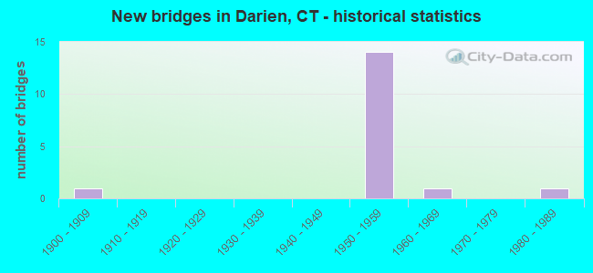
- New bridges - historical statistics
- 11900-1909
- 141950-1959
- 11960-1969
- 11980-1989

- Reconstructed bridges - Historical Statistics
- 41980-1989
- 11990-1999
- 22000-2009


- Bridge Condition - Deck
- 11.1%Very good
- 44.4%Good
- 44.4%Satisfactory

- Bridge Condition - Superstructure
- 44.4%Good
- 11.1%Satisfactory
- 44.4%Fair

- Bridge Condition - Substructure
- 44.4%Good
- 55.6%Satisfactory

- Bridge Condition - Channel
- 33.3%Good
- 50.0%Satisfactory
- 16.7%Fair
Find on map >> Show street view
Structure Number: 4, Location: 0.2 MI S OF SERVICE AREA (Lat: 41.063419, Lng: -73.508114), Route carried "on" structure: Interstate 95, Year Built: 1958, Year Reconstructed: 1990, Status: Open, Structure Length: 2.47m (8.10ft), Average Daily Traffic: 146,000 (year 2017), Truck Traffic: 14%, Average Future Daily Traffic: 216,941 (year 2037), Design Load: HS 20, Features Intersected: BROOKSIDE DRIVE
Minimum Vertical Clearance: 30+ m (98+ ft), Kilometerpoint: 15.578, Lanes on structure: 7, Lanes under structure: 2, Base Highway Network: Yes, Owner: State Highway Agency, Approaching Roadway Width: 29.3m (96.1ft), Skew: 34 degrees, Material/Design: Steel, Design/Construction: Stringer/Multi-beam, Number Of Spans In Main Unit: 1, Length of Maximum Span: 22.6m (74.1ft), Curb-To-Curb Width: 39.3m (128.9ft), Out-to-Out Width: 42.3m (138.8ft)
Condition: Deck: Good, Superstructure: Good, Substructure: Satisfactory, Operating Rating: 87.9 metric tons, Method Used To Determine Operating Rating: Load Factor (LF), Inventory Rating: 52.7 metric tons, Method Used To Determine Inventory Rating: Load Factor (LF), Structural Evaluation: Equal to present minimum criteria, Deck Geometry: Superior to present desirable criteria, Underclear: Meets minimum limits, Approach Roadway Alignment: Equal to present desirable criteria, Designated Inspection Frequency: Every 24 months, Inspection Date: April 2021, Deck Structure Type: Concrete Cast-file-Place, Wearing Surface/Protective System: Wearing Surface: Bituminous, Membrane: Built-up, Deck Protection: Epoxy Coated Reinforcing
Find on map >> Show street view
Structure Number: 41, Location: BETWEEN EXIT 9 AND 10 (Lat: 41.068269, Lng: -73.499508), Route carried "on" structure: City street , Year Built: 1958, Year Reconstructed: 2009, Status: Open, Structure Length: 5.88m (19.29ft), Average Daily Traffic: 4,500 (year 2017), Truck Traffic: 5%, Average Future Daily Traffic: 6,687 (year 2037), Design Load: HL 93, Features Intersected: INTERSTATE 95, Facility Carried by Structure: HOLLOW TREE RDG RD
Minimum Vertical Clearance: 30+ m (98+ ft), Kilometerpoint: 5.938, Lanes on structure: 2, Lanes under structure: 7, Owner: State Highway Agency, Approaching Roadway Width: 12.2m (40.0ft), Skew: 1 degrees, Material/Design: Steel continuous, Design/Construction: Stringer/Multi-beam, Number Of Spans In Main Unit: 2, Length of Maximum Span: 28.3m (92.8ft), Curb or Sidewalk Widths: Left: 1.5m (4.9ft), Right: 1.5m (4.9ft), Curb-To-Curb Width: 12.2m (40.0ft), Out-to-Out Width: 16.1m (52.8ft)
Condition: Deck: Good, Superstructure: Good, Substructure: Satisfactory, Operating Rating: 31.4 metric tons, Method Used To Determine Operating Rating: Load and Resistance Factor Rating (LRFR) rating reported by rating factor(RF) method using HL-93 loadings, Inventory Rating: 24.0 metric tons, Method Used To Determine Inventory Rating: Load and Resistance Factor Rating (LRFR) rating reported by rating factor(RF) method using HL-93 loadings, Structural Evaluation: Equal to present minimum criteria, Deck Geometry: Equal to present minimum criteria, Underclear: High priority of corrective action, Approach Roadway Alignment: Equal to present desirable criteria, Designated Inspection Frequency: Every 24 months, Inspection Date: November 2020, Deck Structure Type: Concrete Cast-file-Place, Wearing Surface/Protective System: Wearing Surface: Bituminous, Membrane: Built-up, Deck Protection: Epoxy Coated Reinforcing
Find on map >> Show street view
Structure Number: 43, Location: JCT OF US ROUTE 1 EXIT 11 (Lat: 41.072472, Lng: -73.474983), Route carried "on" structure: Interstate 95, Year Built: 1958, Year Reconstructed: 1991, Status: Open, Structure Length: 3.93m (12.89ft), Average Daily Traffic: 138,600 (year 2017), Truck Traffic: 15%, Average Future Daily Traffic: 205,946 (year 2037), Design Load: H 20, Features Intersected: US ROUTE 1
Minimum Vertical Clearance: 30+ m (98+ ft), Kilometerpoint: 18.684, Lanes on structure: 6, Lanes under structure: 4, Base Highway Network: Yes, Owner: State Highway Agency, Approaching Roadway Width: 33.8m (110.9ft), Skew: 35 degrees, Material/Design: Steel, Design/Construction: Stringer/Multi-beam, Number Of Spans In Main Unit: 1, Length of Maximum Span: 36.6m (120.1ft), Curb-To-Curb Width: 33.1m (108.6ft), Out-to-Out Width: 36.2m (118.8ft)
Condition: Deck: Satisfactory, Superstructure: Satisfactory, Substructure: Satisfactory, Operating Rating: 72.9 metric tons, Method Used To Determine Operating Rating: Load Factor (LF), Inventory Rating: 43.7 metric tons, Method Used To Determine Inventory Rating: Load Factor (LF), Structural Evaluation: Equal to present minimum criteria, Deck Geometry: Superior to present desirable criteria, Underclear: Meets minimum limits, Approach Roadway Alignment: Equal to present desirable criteria, Designated Inspection Frequency: Every 24 months, Inspection Date: January 2021, Deck Structure Type: Concrete Cast-file-Place, Wearing Surface/Protective System: Wearing Surface: Bituminous, Membrane: Preformed Fabric, Deck Protection: Epoxy Coated Reinforcing
Find on map >> Show street view
Structure Number: 44, Location: 0.4 MI S OF ROUTE 136 (Lat: 41.073839, Lng: -73.469992), Route carried "on" structure: Interstate 95, Year Built: 1952, Year Reconstructed: 2009, Status: Open, Structure Length: 4.97m (16.31ft), Average Daily Traffic: 148,600 (year 2017), Truck Traffic: 9%, Average Future Daily Traffic: 220,805 (year 2037), Design Load: HS 20, Features Intersected: KINGS HWY-GOODWIVES RV
Minimum Vertical Clearance: 30+ m (98+ ft), Kilometerpoint: 19.119, Lanes on structure: 8, Lanes under structure: 2, Base Highway Network: Yes, Owner: State Highway Agency, Approaching Roadway Width: 44.2m (145.0ft), Skew: 30 degrees, Material/Design: Steel continuous, Design/Construction: Stringer/Multi-beam, Number Of Spans In Main Unit: 3, Length of Maximum Span: 19.2m (63.0ft), Curb-To-Curb Width: 41.1m (134.8ft), Out-to-Out Width: 44.1m (144.7ft)
Condition: Deck: Satisfactory, Superstructure: Fair, Substructure: Satisfactory, Channel: Satisfactory, Operating Rating: 36.6 metric tons, Method Used To Determine Operating Rating: Load and Resistance Factor Rating (LRFR) rating reported by rating factor(RF) method using HL-93 loadings, Inventory Rating: 28.2 metric tons, Method Used To Determine Inventory Rating: Load and Resistance Factor Rating (LRFR) rating reported by rating factor(RF) method using HL-93 loadings, Structural Evaluation: Somewhat better than minimum adequacy, Deck Geometry: Superior to present desirable criteria, Underclear: Somewhat better than minimum adequacy, Waterway Adequacy: Superior to present desirable criteria, Approach Roadway Alignment: Equal to present desirable criteria, Designated Inspection Frequency: Every 24 months, Inspection Date: October 2020, Deck Structure Type: Concrete Cast-file-Place, Wearing Surface/Protective System: Wearing Surface: Bituminous, Membrane: Preformed Fabric
Find on map >> Show street view
Structure Number: 45, Location: JCT RT 136 EXIT 12 (Lat: 41.076656, Lng: -73.465022), Route carried "on" structure: Interstate 95, Year Built: 1952, Year Reconstructed: 1991, Status: Open, Structure Length: 1.77m (5.81ft), Average Daily Traffic: 138,700 (year 2017), Truck Traffic: 9%, Average Future Daily Traffic: 206,094 (year 2037), Design Load: HS 20, Features Intersected: ROUTE 136
Minimum Vertical Clearance: 30+ m (98+ ft), Kilometerpoint: 19.682, Lanes on structure: 6, Lanes under structure: 2, Base Highway Network: Yes, Owner: State Highway Agency, Approaching Roadway Width: 33.5m (109.9ft), Skew: 30 degrees, Material/Design: Steel, Design/Construction: Stringer/Multi-beam, Number Of Spans In Main Unit: 1, Length of Maximum Span: 16.3m (53.5ft), Curb-To-Curb Width: 33.5m (109.9ft), Out-to-Out Width: 36.5m (119.8ft)
Condition: Deck: Good, Superstructure: Fair, Substructure: Satisfactory, Operating Rating: 69.7 metric tons, Method Used To Determine Operating Rating: Load and Resistance Factor Rating (LRFR) rating reported by rating factor(RF) method using HL-93 loadings, Inventory Rating: 53.5 metric tons, Method Used To Determine Inventory Rating: Load and Resistance Factor Rating (LRFR) rating reported by rating factor(RF) method using HL-93 loadings, Structural Evaluation: Somewhat better than minimum adequacy, Deck Geometry: Superior to present desirable criteria, Underclear: High priority of corrective action, Approach Roadway Alignment: Equal to present desirable criteria, Designated Inspection Frequency: Every 24 months, Inspection Date: September 2020, Deck Structure Type: Concrete Cast-file-Place, Wearing Surface/Protective System: Wearing Surface: Bituminous, Membrane: Preformed Fabric, Deck Protection: Epoxy Coated Reinforcing
Find on map >> Show street view
Structure Number: 2395, Location: BETWEEN EXITS 10 & 11 (Lat: 41.071592, Lng: -73.481567), Route carried "on" structure: Interstate 95, Year Built: 1958, Year Reconstructed: 1992, Status: Open, Structure Length: 0.64m (2.10ft), Average Daily Traffic: 145,500 (year 2017), Truck Traffic: 14%, Average Future Daily Traffic: 216,198 (year 2037), Design Load: H 20, Features Intersected: STONY BROOK
Minimum Vertical Clearance: 30+ m (98+ ft), Kilometerpoint: 18.137, Lanes on structure: 8, Base Highway Network: Yes, Owner: State Highway Agency, Approaching Roadway Width: 44.2m (145.0ft), Skew: 30 degrees, Design/Construction: Culvert, Number Of Spans In Main Unit: 2, Length of Maximum Span: 3.0m (9.8ft)
Condition: Channel: Satisfactory, Culverts: Satisfactory, Structural Evaluation: Equal to present minimum criteria, Waterway Adequacy: Better than present minimum criteria, Approach Roadway Alignment: Equal to present desirable criteria, Designated Inspection Frequency: Every 24 months, Inspection Date: April 2021
Find on map >> Show street view
Structure Number: 3847, Location: WEST END OF DARIEN STA (Lat: 41.069192, Lng: -73.499186), Route carried "on" structure: City street , Year Built: 1900, Year Reconstructed: 1992, Status: Open, Structure Length: 1.86m (6.10ft), Average Daily Traffic: 4,500 (year 2020), Truck Traffic: 2%, Average Future Daily Traffic: 6,687 (year 2040), Design Load: HS 20, Features Intersected: METRO-NORTH RAILROAD, Facility Carried by Structure: HOLLOW TREE ROAD
Minimum Vertical Clearance: 30+ m (98+ ft), Kilometerpoint: 0.982, Lanes on structure: 2, Maintenance Responsibility: State Highway Agency, Approaching Roadway Width: 8.5m (27.9ft), Material/Design: Prestressed concrete, Design/Construction: Box Beam or Girders - Multiple, Number Of Spans In Main Unit: 1, Length of Maximum Span: 17.7m (58.1ft), Curb or Sidewalk Widths: Left: 0.0m, Right: 1.7m (5.6ft), Curb-To-Curb Width: 8.5m (27.9ft), Out-to-Out Width: 11.2m (36.7ft)
Condition: Deck: Satisfactory, Superstructure: Fair, Substructure: Good, Operating Rating: 28.8 metric tons, Method Used To Determine Operating Rating: Load and Resistance Factor Rating (LRFR) rating reported by rating factor(RF) method using HL-93 loadings, Inventory Rating: 22.0 metric tons, Method Used To Determine Inventory Rating: Load and Resistance Factor Rating (LRFR) rating reported by rating factor(RF) method using HL-93 loadings, Structural Evaluation: Somewhat better than minimum adequacy, Deck Geometry: Meets minimum limits, Underclear: High priority of corrective action, Approach Roadway Alignment: Equal to present minimum criteria, Designated Inspection Frequency: Every 24 months, Inspection Date: November 2020, Deck Structure Type: Other, Wearing Surface/Protective System: Wearing Surface: Bituminous, Membrane: Built-up, Deck Protection: Epoxy Coated Reinforcing
Find on map >> Show street view
Structure Number: 4143, Location: 1.5 MI E OF ROUTE 106 (Lat: 41.082094, Lng: -73.485575), Route carried "on" structure: City street , Year Built: 1950, Status: Open, Structure Length: 0.85m (2.79ft), Average Daily Traffic: 6,732 (year 2021), Truck Traffic: 4%, Average Future Daily Traffic: 10,003 (year 2041), Features Intersected: STONY BROOK, Facility Carried by Structure: MIDDLESEX ROAD
Minimum Vertical Clearance: 30+ m (98+ ft), Kilometerpoint: 0.000, Lanes on structure: 2, Owner: Town or Township Highway Agency, Approaching Roadway Width: 10.1m (33.1ft), Skew: 1 degrees, Material/Design: Concrete, Design/Construction: Slab, Number Of Spans In Main Unit: 1, Length of Maximum Span: 7.3m (24.0ft), Curb or Sidewalk Widths: Left: 0.9m (3.0ft), Right: 0.4m (1.3ft), Curb-To-Curb Width: 9.8m (32.2ft), Out-to-Out Width: 11.8m (38.7ft)
Condition: Deck: Very good, Superstructure: Good, Substructure: Good, Channel: Good, Operating Rating: 42.6 metric tons, Method Used To Determine Operating Rating: Field evaluation and documented engineering judgment, Inventory Rating: 32.7 metric tons, Method Used To Determine Inventory Rating: Field evaluation and documented engineering judgment, Structural Evaluation: Better than present minimum criteria, Deck Geometry: Meets minimum limits, Waterway Adequacy: Equal to present minimum criteria, Approach Roadway Alignment: Meets minimum limits, Designated Inspection Frequency: Every 24 months, Inspection Date: November 2021, Deck Structure Type: Concrete Cast-file-Place, Wearing Surface/Protective System: Wearing Surface: Bituminous
Find on map >> Show street view
Structure Number: 4144, Location: 0.1 MI NO OF SEDGWICK AVE (Lat: 41.079486, Lng: -73.465547), Route carried "on" structure: City street , Year Built: 1956, Status: Open, Structure Length: 0.79m (2.59ft), Average Daily Traffic: 5,740 (year 2021), Truck Traffic: 5%, Average Future Daily Traffic: 8,529 (year 2041), Features Intersected: GOODWIVES RIVER, Facility Carried by Structure: OLD KINGS HWY NORT
Minimum Vertical Clearance: 30+ m (98+ ft), Kilometerpoint: 0.000, Lanes on structure: 2, Owner: Town or Township Highway Agency, Approaching Roadway Width: 7.9m (25.9ft), Skew: 1 degrees, Material/Design: Prestressed concrete, Design/Construction: Slab, Number Of Spans In Main Unit: 1, Length of Maximum Span: 6.1m (20.0ft), Curb or Sidewalk Widths: Left: 0.7m (2.3ft), Right: 1.6m (5.2ft), Curb-To-Curb Width: 8.2m (26.9ft), Out-to-Out Width: 11.3m (37.1ft)
Condition: Deck: Satisfactory, Superstructure: Fair, Substructure: Good, Channel: Satisfactory, Operating Rating: 52.6 metric tons, Method Used To Determine Operating Rating: Field evaluation and documented engineering judgment, Inventory Rating: 30.8 metric tons, Method Used To Determine Inventory Rating: Field evaluation and documented engineering judgment, Structural Evaluation: Somewhat better than minimum adequacy, Deck Geometry: High priority of replacement, Waterway Adequacy: Better than present minimum criteria, Approach Roadway Alignment: Meets minimum limits, Designated Inspection Frequency: Every 24 months, Inspection Date: November 2021, Deck Structure Type: Other, Wearing Surface/Protective System: Wearing Surface: Bituminous
Find on map >> Show street view
Structure Number: 5385, Location: 0.7 MI SOUTH OF I-95 UP (Lat: 41.063569, Lng: -73.481633), Route carried "on" structure: US 1, Year Built: 1986, Status: Open, Structure Length: 1.05m (3.44ft), Average Daily Traffic: 11,800 (year 2020), Truck Traffic: 6%, Average Future Daily Traffic: 17,534 (year 2040), Design Load: HS 20, Features Intersected: STONEY BROOK
Minimum Vertical Clearance: 30+ m (98+ ft), Kilometerpoint: 16.834, Lanes on structure: 4, Base Highway Network: Yes, Owner: State Highway Agency, Approaching Roadway Width: 12.8m (42.0ft), Material/Design: Prestressed concrete, Design/Construction: Box Beam or Girders - Multiple, Number Of Spans In Main Unit: 1, Length of Maximum Span: 9.1m (29.9ft), Curb or Sidewalk Widths: Left: 3.7m (12.1ft), Right: 1.7m (5.6ft), Curb-To-Curb Width: 14.4m (47.2ft), Out-to-Out Width: 20.0m (65.6ft)
Condition: Deck: Good, Superstructure: Good, Substructure: Good, Channel: Fair, Operating Rating: 73.6 metric tons, Method Used To Determine Operating Rating: Load Factor (LF), Inventory Rating: 38.5 metric tons, Method Used To Determine Inventory Rating: Load Factor (LF), Structural Evaluation: Better than present minimum criteria, Deck Geometry: High priority of replacement, Waterway Adequacy: Equal to present minimum criteria, Approach Roadway Alignment: Equal to present desirable criteria, Designated Inspection Frequency: Every 24 months, Inspection Date: September 2021, Deck Structure Type: Other, Wearing Surface/Protective System: Wearing Surface: Bituminous, Membrane: Preformed Fabric
Find on map >> Show street view
Structure Number: 6114, Location: 0.2 MI W OF RAYMOND ST (Lat: 41.077547, Lng: -73.454003), Route carried "on" structure: City street , Year Built: 1966, Status: Open, Structure Length: 0.67m (2.20ft), Average Daily Traffic: 57 (year 2021), Truck Traffic: 4%, Average Future Daily Traffic: 85 (year 2041), Features Intersected: TOKENEKE BROOK, Facility Carried by Structure: LITTLE BROOK ROAD
Minimum Vertical Clearance: 30+ m (98+ ft), Kilometerpoint: 0.000, Lanes on structure: 2, Owner: Town or Township Highway Agency, Approaching Roadway Width: 9.8m (32.2ft), Skew: 4 degrees, Material/Design: Concrete continuous, Design/Construction: Culvert, Number Of Spans In Main Unit: 2, Length of Maximum Span: 3.4m (11.2ft), Curb or Sidewalk Widths: Left: 1.5m (4.9ft), Right: 0.0m, Curb-To-Curb Width: 9.8m (32.2ft), Out-to-Out Width: 11.7m (38.4ft)
Condition: Channel: Good, Culverts: Satisfactory, Operating Rating: 42.6 metric tons, Method Used To Determine Operating Rating: Field evaluation and documented engineering judgment, Inventory Rating: 32.7 metric tons, Method Used To Determine Inventory Rating: Field evaluation and documented engineering judgment, Structural Evaluation: Equal to present minimum criteria, Deck Geometry: Equal to present desirable criteria, Waterway Adequacy: Better than present minimum criteria, Approach Roadway Alignment: Better than present minimum criteria, Designated Inspection Frequency: Every 24 months, Inspection Date: November 2021, Deck Structure Type: Other, Wearing Surface/Protective System: Wearing Surface: Bituminous
Find on map >> Show street view
Structure Number: 41, Location: BETWEEN EXIT 9 AND 10 (Lat: 41.068269, Lng: -73.499508), Route carried "under" structure: Interstate 95, Year Built: 1958, Structure Length: 0. m, Average Daily Traffic: 146,000 (year 2017), Truck Traffic: 14%, Features Intersected: INTERSTATE 95, Facility Carried by Structure: HOLLOW TREE RDG RD
Minimum Vertical Clearance: 5.79m (19.00ft), Kilometerpoint: 16.528, Lanes on structure: 2, Lanes under structure: 7, Material/Design: Steel continuous, Design/Construction: Stringer/Multi-beam, Length of Maximum Span: 28.3m (92.8ft)
Find on map >> Show street view
Structure Number: 42, Location: AT EXIT 10 (Lat: 41.068222, Lng: -73.490558), Route carried "under" structure: Interstate 95, Year Built: 1958, Structure Length: 0. m, Average Daily Traffic: 139,100 (year 2017), Truck Traffic: 14%, Features Intersected: INTERSTATE 95, Facility Carried by Structure: NOROTON AVENUE
Minimum Vertical Clearance: 7.47m (24.51ft), Kilometerpoint: 17.300, Lanes on structure: 4, Lanes under structure: 6, Material/Design: Steel, Design/Construction: Stringer/Multi-beam, Length of Maximum Span: 25.3m (83.0ft)
Find on map >> Show street view
Structure Number: 43, Location: JCT OF US ROUTE 1 EXIT 11 (Lat: 41.072472, Lng: -73.474983), Route carried "under" structure: US 1, Year Built: 1958, Structure Length: 0. m, Average Daily Traffic: 12,900 (year 2017), Truck Traffic: 5%, Features Intersected: US ROUTE 1, Facility Carried by Structure: INTERSTATE-95
Minimum Vertical Clearance: 4.55m (14.93ft), Kilometerpoint: 17.976, Lanes on structure: 6, Lanes under structure: 4, Material/Design: Steel, Design/Construction: Stringer/Multi-beam, Length of Maximum Span: 36.6m (120.1ft)
Find on map >> Show street view
Structure Number: 45, Location: JCT RT 136 EXIT 12 (Lat: 41.076656, Lng: -73.465022), Route carried "under" structure: State highway 136, Year Built: 1952, Structure Length: 0. m, Average Daily Traffic: 11,900 (year 2017), Truck Traffic: 2%, Features Intersected: ROUTE 136, Facility Carried by Structure: INTERSTATE-95
Minimum Vertical Clearance: 4.65m (15.26ft), Kilometerpoint: 0.467, Lanes on structure: 6, Lanes under structure: 2, Material/Design: Steel, Design/Construction: Stringer/Multi-beam, Length of Maximum Span: 16.3m (53.5ft)
Find on map >> Show street view
Structure Number: 47, Location: 0.5 MI WEST NORWALK TL (Lat: 41.084583, Lng: -73.459783), Route carried "under" structure: Interstate 95, Year Built: 1952, Structure Length: 0. m, Average Daily Traffic: 138,700 (year 2018), Truck Traffic: 9%, Features Intersected: INTERSTATE-95, Facility Carried by Structure: OLD KINGS HWY N #1
Minimum Vertical Clearance: 5.18m (16.99ft), Kilometerpoint: 20.664, Lanes on structure: 2, Lanes under structure: 6, Material/Design: Steel, Design/Construction: Stringer/Multi-beam, Length of Maximum Span: 18.0m (59.1ft)
Find on map >> Show street view
Structure Number: 48, Location: I-95 NB EXIT NO. 13 (Lat: 41.089639, Lng: -73.453689), Route carried "under" structure: Ramp Interstate 95, Year Built: 1956, Structure Length: 0. m, Average Daily Traffic: 8,200 (year 2017), Truck Traffic: 2%, Features Intersected: I-95 RMP 047/FIVE MI RIV
Minimum Vertical Clearance: 4.47m (14.67ft), Kilometerpoint: 0.322, Lanes on structure: 6, Lanes under structure: 1, Material/Design: Steel, Design/Construction: Stringer/Multi-beam, Length of Maximum Span: 25.0m (82.0ft)