Bridge Statistics for Dearborn, Michigan (MI)
Condition, Traffic, Stress, Structural Evaluation, Project Costs
- National Bridge Inventory (NBI) Statistics
- 122Number of bridges
- 1,293ft / 394mTotal length
- $1,713,000Total costs
- 4,435,331Total average daily traffic
- 319,160Total average daily truck traffic
- National Bridge Inventory (NBI) Registered Bridges for Dearborn
- No street view available for this location
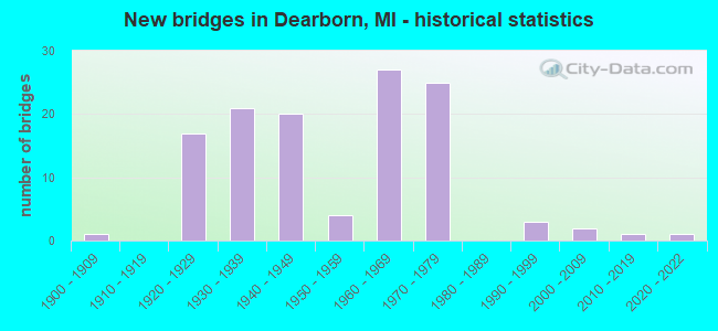
- New bridges - historical statistics
- 11900-1909
- 171920-1929
- 211930-1939
- 201940-1949
- 41950-1959
- 271960-1969
- 251970-1979
- 31990-1999
- 22000-2009
- 12010-2019
- 12020-2022
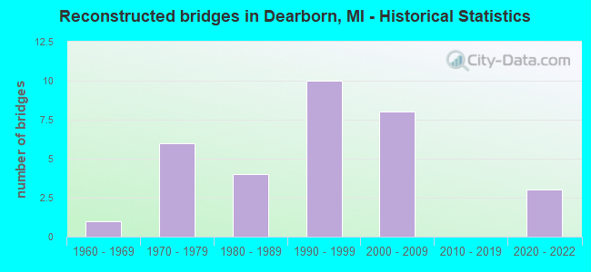
- Reconstructed bridges - Historical Statistics
- 11960-1969
- 61970-1979
- 41980-1989
- 101990-1999
- 82000-2009
- 02010-2019
- 32020-2022
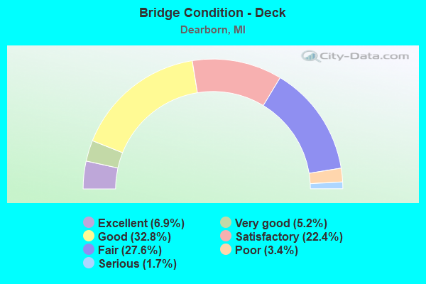
- Bridge Condition - Deck
- 6.9%Excellent
- 5.2%Very good
- 32.8%Good
- 22.4%Satisfactory
- 27.6%Fair
- 3.4%Poor
- 1.7%Serious
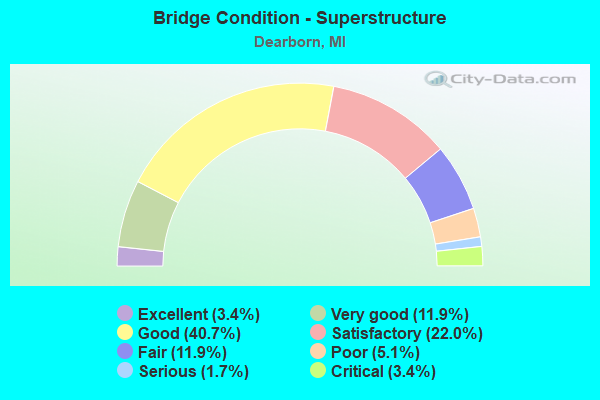
- Bridge Condition - Superstructure
- 3.4%Excellent
- 11.9%Very good
- 40.7%Good
- 22.0%Satisfactory
- 11.9%Fair
- 5.1%Poor
- 1.7%Serious
- 3.4%Critical
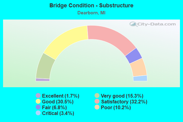
- Bridge Condition - Substructure
- 1.7%Excellent
- 15.3%Very good
- 30.5%Good
- 32.2%Satisfactory
- 6.8%Fair
- 10.2%Poor
- 3.4%Critical
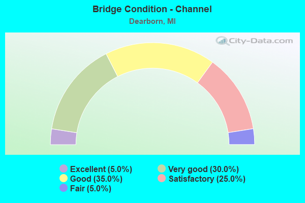
- Bridge Condition - Channel
- 5.0%Excellent
- 30.0%Very good
- 35.0%Good
- 25.0%Satisfactory
- 5.0%Fair
Find on map >> Show street view
Structure Number: 1114, Location: GIRARD TWP SEC 35 (Lat: 41.985561, Lng: -84.964267), Route carried "on" structure: County highway 1274, Year Built: 2012, Status: Open, Structure Length: 1.34m (4.40ft), Average Daily Traffic: 3,092 (year 2012), Truck Traffic: 5%, Average Future Daily Traffic: 4,595 (year 2032), Design Load: Greater than HL93, Features Intersected: COUNTY DRAIN #33, Facility Carried by Structure: JONESVILLE ROAD
Minimum Vertical Clearance: 30.48m (100.00ft), Kilometerpoint: 4.638, Lanes on structure: 2, Owner: County Highway Agency, Approaching Roadway Width: 11.4m (37.4ft), Material/Design: Prestressed concrete, Design/Construction: Box Beam or Girders - Multiple, Number Of Spans In Main Unit: 1, Length of Maximum Span: 13.0m (42.7ft), Curb-To-Curb Width: 11.6m (38.1ft), Out-to-Out Width: 12.3m (40.4ft)
Condition: Deck: Good, Superstructure: Very good, Substructure: Very good, Channel: Good, Operating Rating: 71.9 metric tons, Method Used To Determine Operating Rating: Load and Resistance Factor Rating (LRFR) rating reported by rating factor(RF) method using HL-93 loadings, Inventory Rating: 55.1 metric tons, Method Used To Determine Inventory Rating: Load and Resistance Factor Rating (LRFR) rating reported by rating factor(RF) method using HL-93 loadings, Structural Evaluation: Equal to present desirable criteria, Deck Geometry: Somewhat better than minimum adequacy, Waterway Adequacy: Equal to present desirable criteria, Approach Roadway Alignment: Equal to present desirable criteria, Designated Inspection Frequency: Every 24 months, Inspection Date: October 2020, Deck Structure Type: Concrete Precast Panels, Wearing Surface/Protective System: Wearing Surface: Monolithic Concrete, Deck Protection: Epoxy Coated Reinforcing
Find on map >> Show street view
Structure Number: 1116, Location: SHERWOOD TWP SEC 28 (Lat: 42.011742, Lng: -85.239925), Route carried "on" structure: County highway 1203, Year Built: 1977, Status: Open, Structure Length: 4.20m (13.78ft), Average Daily Traffic: 468 (year 2004), Truck Traffic: 6%, Average Future Daily Traffic: 599 (year 2024), Design Load: HS 20, Features Intersected: ST JOSEPH RIVER, Facility Carried by Structure: ARNEY ROAD
Minimum Vertical Clearance: 30.48m (100.00ft), Kilometerpoint: 2.771, Lanes on structure: 2, Owner: County Highway Agency, Approaching Roadway Width: 9.1m (29.9ft), Skew: 2 degrees, Material/Design: Prestressed concrete, Design/Construction: Box Beam or Girders - Multiple, Number Of Spans In Main Unit: 3, Length of Maximum Span: 13.6m (44.6ft), Curb-To-Curb Width: 11.0m (36.1ft), Out-to-Out Width: 11.1m (36.4ft)
Condition: Deck: Fair, Superstructure: Fair, Substructure: Satisfactory, Channel: Satisfactory, Operating Rating: 69.5 metric tons, Method Used To Determine Operating Rating: Load Factor (LF), Inventory Rating: 41.6 metric tons, Method Used To Determine Inventory Rating: Load Factor (LF), Structural Evaluation: Somewhat better than minimum adequacy, Deck Geometry: Better than present minimum criteria, Waterway Adequacy: Superior to present desirable criteria, Approach Roadway Alignment: Equal to present desirable criteria, Designated Inspection Frequency: Every 24 months, Inspection Date: October 2020, Deck Structure Type: Concrete Precast Panels, Wearing Surface/Protective System: Wearing Surface: Bituminous, Membrane: Preformed Fabric
Find on map >> Show street view
Structure Number: 1131, Location: COLDWATER TWP SEC 9 (Lat: 41.963900, Lng: -85.018208), Route carried "on" structure: County highway 2035, Year Built: 1935, Status: Posted for load, Structure Length: 1.06m (3.48ft), Average Daily Traffic: 2,681 (year 2004), Truck Traffic: 8%, Average Future Daily Traffic: 2,833 (year 2024), Design Load: HS 20+Mod, Features Intersected: COLD CREEK, Facility Carried by Structure: UNION CITY ROAD
Minimum Vertical Clearance: 30.48m (100.00ft), Kilometerpoint: 2.887, Lanes on structure: 2, Owner: County Highway Agency, Approaching Roadway Width: 10.4m (34.1ft), Material/Design: Steel, Design/Construction: Stringer/Multi-beam, Number Of Spans In Main Unit: 1, Length of Maximum Span: 10.3m (33.8ft), Curb-To-Curb Width: 7.3m (24.0ft), Out-to-Out Width: 10.9m (35.8ft)
Condition: Deck: Satisfactory, Superstructure: Poor, Substructure: Satisfactory, Channel: Good, Operating Rating: 49.6 metric tons, Method Used To Determine Operating Rating: Load Factor (LF) rating reported by rating factor (RF) method using MS18 loading, Inventory Rating: 29.8 metric tons, Method Used To Determine Inventory Rating: Load Factor (LF) rating reported by rating factor (RF) method using MS18 loading, Structural Evaluation: Meets minimum limits, Deck Geometry: High priority of replacement, Waterway Adequacy: Equal to present desirable criteria, Approach Roadway Alignment: Equal to present desirable criteria, Bridge Posting: Required (Relationship of Operating Rating to Maximum Legal Load: 10.0 - 19.9% below), Designated Inspection Frequency: Every 12 months, Inspection Date: October 2021, Deck Structure Type: Concrete Cast-file-Place, Wearing Surface/Protective System: Wearing Surface: Bituminous
Find on map >> Show street view
Structure Number: 1134, Location: OVID TWP SEC 16 (Lat: 41.864686, Lng: -85.004903), Route carried "on" structure: County highway 1265, Year Built: 2021, Status: Open, Structure Length: 1.52m (4.99ft), Average Daily Traffic: 2,300 (year 2020), Truck Traffic: 6%, Average Future Daily Traffic: 3,418 (year 2040), Design Load: Greater than HL93, Features Intersected: COLDWATER RIVER, Facility Carried by Structure: SOUTH ANGOLA ROAD
Minimum Vertical Clearance: 30.48m (100.00ft), Kilometerpoint: 12.037, Lanes on structure: 2, Owner: County Highway Agency, Approaching Roadway Width: 12.2m (40.0ft), Material/Design: Prestressed concrete, Design/Construction: Box Beam or Girders - Single/Spread, Number Of Spans In Main Unit: 1, Length of Maximum Span: 14.8m (48.6ft), Curb-To-Curb Width: 12.2m (40.0ft), Out-to-Out Width: 13.1m (43.0ft)
Condition: Deck: Excellent, Superstructure: Excellent, Substructure: Excellent, Channel: Good, Operating Rating: 62.9 metric tons, Method Used To Determine Operating Rating: Load and Resistance Factor Rating (LRFR) rating reported by rating factor(RF) method using HL-93 loadings, Inventory Rating: 48.3 metric tons, Method Used To Determine Inventory Rating: Load and Resistance Factor Rating (LRFR) rating reported by rating factor(RF) method using HL-93 loadings, Structural Evaluation: Superior to present desirable criteria, Deck Geometry: Equal to present minimum criteria, Waterway Adequacy: Better than present minimum criteria, Approach Roadway Alignment: Equal to present desirable criteria, Designated Inspection Frequency: Every 24 months, Inspection Date: October 2021, Deck Structure Type: Concrete Cast-file-Place, Wearing Surface/Protective System: Wearing Surface: Monolithic Concrete, Deck Protection: Epoxy Coated Reinforcing
Find on map >> Show street view
Structure Number: 1205, Location: 1.7 MI N OF I-94 (Lat: 42.293750, Lng: -85.178767), Route carried "on" structure: Interstate 194, Year Built: 1960, Status: Open, Structure Length: 3.78m (12.40ft), Average Daily Traffic: 13,141 (year 2007), Truck Traffic: 6%, Average Future Daily Traffic: 14,357 (year 2018), Design Load: HS 20, Features Intersected: GOLDEN AVE
Minimum Vertical Clearance: 30.48m (100.00ft), Kilometerpoint: 4.382, Lanes on structure: 3, Lanes under structure: 2, Base Highway Network: Yes (Inventory Route: 129, Subroute: 2), Owner: State Highway Agency, Approaching Roadway Width: 12.8m (42.0ft), Material/Design: Concrete continuous, Design/Construction: Tee Beam, Number Of Spans In Main Unit: 3, Length of Maximum Span: 15.5m (50.9ft), Curb-To-Curb Width: 12.8m (42.0ft), Out-to-Out Width: 13.1m (43.0ft)
Condition: Deck: Fair, Superstructure: Satisfactory, Substructure: Fair, Operating Rating: 63.5 metric tons, Method Used To Determine Operating Rating: Load Factor (LF) rating reported by rating factor (RF) method using MS18 loading, Inventory Rating: 38.9 metric tons, Method Used To Determine Inventory Rating: Load Factor (LF) rating reported by rating factor (RF) method using MS18 loading, Structural Evaluation: Somewhat better than minimum adequacy, Deck Geometry: High priority of replacement, Underclear: Meets minimum limits, Approach Roadway Alignment: Equal to present desirable criteria, Designated Inspection Frequency: Every 24 months, Inspection Date: September 2021, Deck Structure Type: Concrete Cast-file-Place, Wearing Surface/Protective System: Wearing Surface: Monolithic Concrete
Find on map >> Show street view
Structure Number: 1223, Location: 2.3 MI N OF BRANCH COL (Lat: 42.100269, Lng: -84.996483), Route carried "on" structure: Interstate 69, Year Built: 1968, Year Reconstructed: 2003, Status: Open, Structure Length: 4.27m (14.01ft), Average Daily Traffic: 19,534 (year 2014), Truck Traffic: 26%, Average Future Daily Traffic: 22,464 (year 2034), Design Load: HS 20+Mod, Features Intersected: CONRAIL (ABN)
Minimum Vertical Clearance: 30.48m (100.00ft), Kilometerpoint: 3.576, Lanes on structure: 3, Base Highway Network: Yes (Inventory Route: 129, Subroute: 2), Owner: State Highway Agency, Approaching Roadway Width: 12.4m (40.7ft), Skew: 1 degrees, Material/Design: Steel, Design/Construction: Stringer/Multi-beam, Number Of Spans In Main Unit: 3, Length of Maximum Span: 15.8m (51.8ft), Curb-To-Curb Width: 16.8m (55.1ft), Out-to-Out Width: 17.8m (58.4ft)
Condition: Deck: Good, Superstructure: Fair, Substructure: Good, Operating Rating: 80.0 metric tons, Method Used To Determine Operating Rating: Load Factor (LF) rating reported by rating factor (RF) method using MS18 loading, Inventory Rating: 48.0 metric tons, Method Used To Determine Inventory Rating: Load Factor (LF) rating reported by rating factor (RF) method using MS18 loading, Structural Evaluation: Somewhat better than minimum adequacy, Deck Geometry: Equal to present minimum criteria, Approach Roadway Alignment: Equal to present desirable criteria, Designated Inspection Frequency: Every 24 months, Inspection Date: June 2021, Deck Structure Type: Concrete Cast-file-Place, Wearing Surface/Protective System: Wearing Surface: Monolithic Concrete, Deck Protection: Epoxy Coated Reinforcing
Find on map >> Show street view
Structure Number: 1224, Location: 1.6 MI N OF BRANCH COL (Lat: 42.091828, Lng: -84.997336), Route carried "on" structure: County highway , Year Built: 1968, Status: Open, Structure Length: 7.32m (24.02ft), Average Daily Traffic: 777 (year 1992), Truck Traffic: 3%, Average Future Daily Traffic: 963 (year 2000), Design Load: H 15, Features Intersected: I-69, Facility Carried by Structure: JACKSON RD
Minimum Vertical Clearance: 30.48m (100.00ft), Kilometerpoint: 3.579, Lanes on structure: 2, Lanes under structure: 4, Owner: State Highway Agency, Approaching Roadway Width: 7.0m (23.0ft), Skew: 1 degrees, Material/Design: Steel, Design/Construction: Stringer/Multi-beam, Number Of Spans In Main Unit: 4, Length of Maximum Span: 25.9m (85.0ft), Curb or Sidewalk Widths: Left: 1.0m (3.3ft), Right: 1.0m (3.3ft), Curb-To-Curb Width: 8.5m (27.9ft), Out-to-Out Width: 10.5m (34.4ft)
Condition: Deck: Fair, Superstructure: Fair, Substructure: Satisfactory, Operating Rating: 67.4 metric tons, Method Used To Determine Operating Rating: Load Factor (LF) rating reported by rating factor (RF) method using MS18 loading, Inventory Rating: 40.2 metric tons, Method Used To Determine Inventory Rating: Load Factor (LF) rating reported by rating factor (RF) method using MS18 loading, Structural Evaluation: Somewhat better than minimum adequacy, Deck Geometry: Somewhat better than minimum adequacy, Underclear: Somewhat better than minimum adequacy, Approach Roadway Alignment: Equal to present desirable criteria, Designated Inspection Frequency: Every 24 months, Inspection Date: June 2021, Deck Structure Type: Concrete Cast-file-Place, Wearing Surface/Protective System: Wearing Surface: Monolithic Concrete
Find on map >> Show street view
Structure Number: 1231, Location: 1.5 MI S OF I-94 (Lat: 42.275778, Lng: -84.992883), Route carried "on" structure: County highway 2046, Year Built: 1968, Status: Open, Structure Length: 9.75m (31.99ft), Average Daily Traffic: 2,200 (year 1988), Truck Traffic: 3%, Average Future Daily Traffic: 3,000 (year 2000), Design Load: H 20, Features Intersected: I-69, Facility Carried by Structure: VERONA RD
Minimum Vertical Clearance: 30.48m (100.00ft), Kilometerpoint: 18.183, Lanes on structure: 2, Lanes under structure: 5, Owner: State Highway Agency, Approaching Roadway Width: 10.4m (34.1ft), Skew: 2 degrees, Material/Design: Steel, Design/Construction: Stringer/Multi-beam, Number Of Spans In Main Unit: 4, Length of Maximum Span: 30.8m (101.0ft), Curb or Sidewalk Widths: Left: 0.1m (0.3ft), Right: 0.1m (0.3ft), Curb-To-Curb Width: 9.1m (29.9ft), Out-to-Out Width: 11.1m (36.4ft)
Condition: Deck: Good, Superstructure: Fair, Substructure: Good, Operating Rating: 66.7 metric tons, Method Used To Determine Operating Rating: Load Factor (LF) rating reported by rating factor (RF) method using MS18 loading, Inventory Rating: 39.9 metric tons, Method Used To Determine Inventory Rating: Load Factor (LF) rating reported by rating factor (RF) method using MS18 loading, Structural Evaluation: Somewhat better than minimum adequacy, Deck Geometry: Meets minimum limits, Underclear: Somewhat better than minimum adequacy, Approach Roadway Alignment: Equal to present desirable criteria, Designated Inspection Frequency: Every 24 months, Inspection Date: June 2021, Deck Structure Type: Concrete Cast-file-Place, Wearing Surface/Protective System: Wearing Surface: Monolithic Concrete
Find on map >> Show street view
Structure Number: 1232, Location: @ I-94 (Lat: 42.297614, Lng: -84.997161), Route carried "on" structure: Interstate 69, Year Built: 1968, Year Reconstructed: 2006, Status: Open, Structure Length: 10.85m (35.60ft), Average Daily Traffic: 7,500 (year 1995), Truck Traffic: 30%, Average Future Daily Traffic: 8,760 (year 2015), Design Load: HS 20+Mod, Features Intersected: I-94
Minimum Vertical Clearance: 30.48m (100.00ft), Kilometerpoint: 0.768, Lanes on structure: 2, Lanes under structure: 8, Base Highway Network: Yes (Inventory Route: 313, Subroute: 9), Owner: State Highway Agency, Approaching Roadway Width: 11.6m (38.1ft), Material/Design: Steel, Design/Construction: Stringer/Multi-beam, Number Of Spans In Main Unit: 4, Length of Maximum Span: 28.3m (92.8ft), Curb-To-Curb Width: 9.6m (31.5ft), Out-to-Out Width: 10.6m (34.8ft)
Condition: Deck: Satisfactory, Superstructure: Satisfactory, Substructure: Satisfactory, Operating Rating: 59.6 metric tons, Method Used To Determine Operating Rating: Load Factor (LF) rating reported by rating factor (RF) method using MS18 loading, Inventory Rating: 35.6 metric tons, Method Used To Determine Inventory Rating: Load Factor (LF) rating reported by rating factor (RF) method using MS18 loading, Structural Evaluation: Equal to present minimum criteria, Deck Geometry: Meets minimum limits, Underclear: Equal to present minimum criteria, Approach Roadway Alignment: Equal to present desirable criteria, Designated Inspection Frequency: Every 24 months, Inspection Date: June 2021, Deck Structure Type: Concrete Cast-file-Place, Wearing Surface/Protective System: Wearing Surface: Latex Concrete
Find on map >> Show street view
Structure Number: 11133, Location: IN DEARBORN (Lat: 42.300008, Lng: -83.183089), Route carried "on" structure: Interstate 94, Year Built: 1971, Year Reconstructed: 2004, Status: Open, Structure Length: 5.42m (17.78ft), Average Daily Traffic: 98,506 (year 2007), Truck Traffic: 16%, Average Future Daily Traffic: 89,700 (year 2018), Design Load: HS 20, Features Intersected: GREENFIELD RD
Minimum Vertical Clearance: 30.48m (100.00ft), Kilometerpoint: 32.804, Lanes on structure: 6, Lanes under structure: 4, Base Highway Network: Yes (Inventory Route: 157, Subroute: 5), Owner: State Highway Agency, Approaching Roadway Width: 34.1m (111.9ft), Skew: 32 degrees, Material/Design: Steel, Design/Construction: Stringer/Multi-beam, Number Of Spans In Main Unit: 2, Length of Maximum Span: 27.1m (88.9ft), Curb or Sidewalk Widths: Left: 0.2m (0.7ft), Right: 0.2m (0.7ft), Curb-To-Curb Width: 36.5m (119.8ft), Out-to-Out Width: 37.2m (122.0ft)
Condition: Deck: Good, Superstructure: Good, Substructure: Good, Operating Rating: 94.3 metric tons, Method Used To Determine Operating Rating: Load Factor (LF) rating reported by rating factor (RF) method using MS18 loading, Inventory Rating: 56.7 metric tons, Method Used To Determine Inventory Rating: Load Factor (LF) rating reported by rating factor (RF) method using MS18 loading, Structural Evaluation: Better than present minimum criteria, Deck Geometry: Superior to present desirable criteria, Underclear: Somewhat better than minimum adequacy, Approach Roadway Alignment: Better than present minimum criteria, Designated Inspection Frequency: Every 24 months, Inspection Date: September 2021, Bridge Improvement Cost: $520,000, Deck Structure Type: Concrete Cast-file-Place, Wearing Surface/Protective System: Wearing Surface: Monolithic Concrete, Deck Protection: Other
Find on map >> Show street view
Structure Number: 11134, Location: IN DEARBORN (Lat: 42.302672, Lng: -83.180664), Route carried "on" structure: Interstate 94, Year Built: 1971, Year Reconstructed: 2004, Status: Open, Structure Length: 4.29m (14.07ft), Average Daily Traffic: 98,506 (year 2007), Truck Traffic: 16%, Average Future Daily Traffic: 89,400 (year 2018), Design Load: HS 20+Mod, Features Intersected: ENT TO FORD PLANT
Minimum Vertical Clearance: 30.48m (100.00ft), Kilometerpoint: 33.162, Lanes on structure: 8, Lanes under structure: 4, Base Highway Network: Yes (Inventory Route: 157, Subroute: 5), Owner: State Highway Agency, Approaching Roadway Width: 34.1m (111.9ft), Skew: 31 degrees, Material/Design: Prestressed concrete, Design/Construction: Box Beam or Girders - Multiple, Number Of Spans In Main Unit: 4, Length of Maximum Span: 12.2m (40.0ft), Curb or Sidewalk Widths: Left: 0.2m (0.7ft), Right: 0.2m (0.7ft), Curb-To-Curb Width: 38.4m (126.0ft), Out-to-Out Width: 39.1m (128.3ft)
Condition: Deck: Satisfactory, Superstructure: Poor, Substructure: Satisfactory, Operating Rating: 59.9 metric tons, Method Used To Determine Operating Rating: Load Factor (LF) rating reported by rating factor (RF) method using MS18 loading, Inventory Rating: 31.4 metric tons, Method Used To Determine Inventory Rating: Load Factor (LF) rating reported by rating factor (RF) method using MS18 loading, Structural Evaluation: Meets minimum limits, Deck Geometry: Superior to present desirable criteria, Underclear: High priority of corrective action, Approach Roadway Alignment: Better than present minimum criteria, Designated Inspection Frequency: Every 24 months, Other Special Inspection Frequency: Every 18 months, Inspection Date: September 2021, Other Special Inspection Date: September 2020, Deck Structure Type: Concrete Cast-file-Place, Wearing Surface/Protective System: Wearing Surface: Monolithic Concrete, Deck Protection: Epoxy Coated Reinforcing
Find on map >> Show street view
Structure Number: 11135, Location: IN DEARBORN (Lat: 42.308528, Lng: -83.175347), Route carried "on" structure: City street 2057, Year Built: 1978, Status: Open, Structure Length: 10.27m (33.69ft), Average Daily Traffic: 19,830 (year 1978), Average Future Daily Traffic: 19,830 (year 2010), Design Load: HS 20, Features Intersected: I-94, Facility Carried by Structure: SCHAEFER HWY
Minimum Vertical Clearance: 30.48m (100.00ft), Kilometerpoint: 3.760, Lanes on structure: 6, Lanes under structure: 6, Owner: State Highway Agency, Approaching Roadway Width: 18.2m (59.7ft), Skew: 5 degrees, Material/Design: Steel, Design/Construction: Stringer/Multi-beam, Number Of Spans In Main Unit: 2, Length of Maximum Span: 51.2m (168.0ft), Curb or Sidewalk Widths: Left: 2.6m (8.5ft), Right: 2.6m (8.5ft), Curb-To-Curb Width: 18.2m (59.7ft), Out-to-Out Width: 24.3m (79.7ft)
Condition: Deck: Satisfactory, Superstructure: Good, Substructure: Good, Operating Rating: 79.7 metric tons, Method Used To Determine Operating Rating: Load Factor (LF) rating reported by rating factor (RF) method using MS18 loading, Inventory Rating: 47.6 metric tons, Method Used To Determine Inventory Rating: Load Factor (LF) rating reported by rating factor (RF) method using MS18 loading, Structural Evaluation: Better than present minimum criteria, Deck Geometry: High priority of replacement, Underclear: Meets minimum limits, Approach Roadway Alignment: Equal to present desirable criteria, Length Of Structure Improvement: 10.27m (33.69ft), Designated Inspection Frequency: Every 24 months, Inspection Date: September 2021, Bridge Improvement Cost: $815,000, Roadway Improvement Cost: $49,000, Total Project Cost: $578,000, Deck Structure Type: Concrete Cast-file-Place, Wearing Surface/Protective System: Wearing Surface: Latex Concrete
Find on map >> Show street view
Structure Number: 11136, Location: IN DEARBORN (Lat: 42.315164, Lng: -83.169514), Route carried "on" structure: County highway 2057, Year Built: 1963, Year Reconstructed: 2005, Status: Open, Structure Length: 8.62m (28.28ft), Average Daily Traffic: 17,500 (year 1978), Average Future Daily Traffic: 17,500 (year 1977), Design Load: HS 20, Features Intersected: I-94, Facility Carried by Structure: ROTUNDA DRIVE
Minimum Vertical Clearance: 30.48m (100.00ft), Kilometerpoint: 6.780, Lanes on structure: 5, Lanes under structure: 8, Owner: State Highway Agency, Approaching Roadway Width: 18.2m (59.7ft), Skew: 4 degrees, Material/Design: Steel, Design/Construction: Stringer/Multi-beam, Number Of Spans In Main Unit: 4, Length of Maximum Span: 27.1m (88.9ft), Curb or Sidewalk Widths: Left: 1.8m (5.9ft), Right: 1.8m (5.9ft), Curb-To-Curb Width: 19.5m (64.0ft), Out-to-Out Width: 23.9m (78.4ft)
Condition: Deck: Good, Superstructure: Good, Substructure: Satisfactory, Operating Rating: 72.3 metric tons, Method Used To Determine Operating Rating: Load Factor (LF) rating reported by rating factor (RF) method using MS18 loading, Inventory Rating: 43.4 metric tons, Method Used To Determine Inventory Rating: Load Factor (LF) rating reported by rating factor (RF) method using MS18 loading, Structural Evaluation: Equal to present minimum criteria, Deck Geometry: Meets minimum limits, Underclear: High priority of corrective action, Approach Roadway Alignment: Better than present minimum criteria, Designated Inspection Frequency: Every 24 months, Inspection Date: September 2021, Deck Structure Type: Concrete Cast-file-Place, Wearing Surface/Protective System: Wearing Surface: Latex Concrete, Deck Protection: Epoxy Coated Reinforcing
Find on map >> Show street view
Structure Number: 11137, Location: IN DEARBORN (Lat: 42.320653, Lng: -83.165025), Route carried "on" structure: County highway 2057, Year Built: 1970, Year Reconstructed: 2004, Status: Open, Structure Length: 7.71m (25.30ft), Average Daily Traffic: 22,136 (year 2010), Average Future Daily Traffic: 24,350 (year 2025), Design Load: HS 20, Features Intersected: I-94, Facility Carried by Structure: MILLER RD
Minimum Vertical Clearance: 30.48m (100.00ft), Kilometerpoint: 3.916, Lanes on structure: 6, Lanes under structure: 8, Owner: State Highway Agency, Approaching Roadway Width: 18.2m (59.7ft), Skew: 3 degrees, Material/Design: Steel, Design/Construction: Stringer/Multi-beam, Number Of Spans In Main Unit: 4, Length of Maximum Span: 20.7m (67.9ft), Curb or Sidewalk Widths: Left: 0.4m (1.3ft), Right: 1.4m (4.6ft), Curb-To-Curb Width: 18.2m (59.7ft), Out-to-Out Width: 20.8m (68.2ft)
Condition: Deck: Satisfactory, Superstructure: Good, Substructure: Satisfactory, Operating Rating: 88.5 metric tons, Method Used To Determine Operating Rating: Load Factor (LF) rating reported by rating factor (RF) method using MS18 loading, Inventory Rating: 52.8 metric tons, Method Used To Determine Inventory Rating: Load Factor (LF) rating reported by rating factor (RF) method using MS18 loading, Structural Evaluation: Equal to present minimum criteria, Deck Geometry: High priority of replacement, Underclear: Meets minimum limits, Approach Roadway Alignment: Better than present minimum criteria, Length Of Structure Improvement: 7.71m (25.30ft), Designated Inspection Frequency: Every 24 months, Inspection Date: September 2021, Bridge Improvement Cost: $596,000, Roadway Improvement Cost: $32,000, Total Project Cost: $380,000, Deck Structure Type: Concrete Cast-file-Place, Wearing Surface/Protective System: Wearing Surface: Latex Concrete
Find on map >> Show street view
Structure Number: 11138, Location: IN DEARBORN (Lat: 42.324436, Lng: -83.162289), Route carried "on" structure: Ramp US 12, Year Built: 1948, Status: Open, Structure Length: 7.98m (26.18ft), Average Daily Traffic: 14,880 (year 1982), Average Future Daily Traffic: 14,880 (year 1977), Design Load: HS 20, Features Intersected: I-94
Minimum Vertical Clearance: 30.48m (100.00ft), Kilometerpoint: 0.285, Lanes on structure: 3, Lanes under structure: 6, Owner: State Highway Agency, Approaching Roadway Width: 12.8m (42.0ft), Skew: 9 degrees, Material/Design: Steel, Design/Construction: Stringer/Multi-beam, Number Of Spans In Main Unit: 5, Length of Maximum Span: 19.5m (64.0ft), Curb-To-Curb Width: 13.4m (44.0ft), Out-to-Out Width: 13.9m (45.6ft)
Condition: Deck: Very good, Superstructure: Good, Substructure: Good, Operating Rating: 97.2 metric tons, Method Used To Determine Operating Rating: Load Factor (LF) rating reported by rating factor (RF) method using MS18 loading, Inventory Rating: 62.2 metric tons, Method Used To Determine Inventory Rating: Load Factor (LF) rating reported by rating factor (RF) method using MS18 loading, Structural Evaluation: Better than present minimum criteria, Deck Geometry: Somewhat better than minimum adequacy, Underclear: High priority of corrective action, Approach Roadway Alignment: Equal to present desirable criteria, Designated Inspection Frequency: Every 24 months, Inspection Date: September 2021, Deck Structure Type: Concrete Cast-file-Place, Wearing Surface/Protective System: Wearing Surface: Latex Concrete
Find on map >> Show street view
Structure Number: 11139, Location: IN DEARBORN (Lat: 42.326242, Lng: -83.161914), Route carried "on" structure: US 12, Year Built: 1944, Year Reconstructed: 1968, Status: Open, Structure Length: 1.52m (4.99ft), Average Daily Traffic: 28,335 (year 2007), Truck Traffic: 5%, Average Future Daily Traffic: 31,582 (year 2018), Design Load: HS 20, Features Intersected: I-94 RAMP
Minimum Vertical Clearance: 30.48m (100.00ft), Kilometerpoint: 2.541, Lanes on structure: 9, Lanes under structure: 2, Base Highway Network: Yes (Inventory Route: 157, Subroute: 3), Owner: State Highway Agency, Approaching Roadway Width: 27.4m (89.9ft), Skew: 1 degrees, Material/Design: Steel, Design/Construction: Stringer/Multi-beam, Number Of Spans In Main Unit: 1, Length of Maximum Span: 15.2m (49.9ft), Curb or Sidewalk Widths: Left: 3.9m (12.8ft), Right: 3.9m (12.8ft), Curb-To-Curb Width: 27.4m (89.9ft), Out-to-Out Width: 35.9m (117.8ft)
Condition: Deck: Good, Superstructure: Good, Substructure: Satisfactory, Operating Rating: 62.2 metric tons, Method Used To Determine Operating Rating: Load Factor (LF) rating reported by rating factor (RF) method using MS18 loading, Inventory Rating: 37.3 metric tons, Method Used To Determine Inventory Rating: Load Factor (LF) rating reported by rating factor (RF) method using MS18 loading, Structural Evaluation: Equal to present minimum criteria, Deck Geometry: High priority of replacement, Underclear: High priority of corrective action, Approach Roadway Alignment: Better than present minimum criteria, Designated Inspection Frequency: Every 24 months, Inspection Date: September 2021, Bridge Improvement Cost: $45,000, Deck Structure Type: Concrete Cast-file-Place, Wearing Surface/Protective System: Wearing Surface: Latex Concrete
Find on map >> Show street view
Structure Number: 1114, Location: IN DEARBORN (Lat: 42.326614, Lng: -83.160603), Route carried "on" structure: US 12, Year Built: 1948, Year Reconstructed: 1996, Status: Open, Structure Length: 6.82m (22.38ft), Average Daily Traffic: 28,335 (year 2007), Truck Traffic: 4%, Average Future Daily Traffic: 12,250 (year 2026), Design Load: HS 20, Features Intersected: I-94
Minimum Vertical Clearance: 30.48m (100.00ft), Kilometerpoint: 2.657, Lanes on structure: 9, Lanes under structure: 6, Base Highway Network: Yes (Inventory Route: 157, Subroute: 3), Owner: State Highway Agency, Approaching Roadway Width: 27.4m (89.9ft), Skew: 5 degrees, Material/Design: Steel, Design/Construction: Stringer/Multi-beam, Number Of Spans In Main Unit: 2, Length of Maximum Span: 36.3m (119.1ft), Curb or Sidewalk Widths: Left: 3.8m (12.5ft), Right: 2.4m (7.9ft), Curb-To-Curb Width: 27.4m (89.9ft), Out-to-Out Width: 35.9m (117.8ft)
Condition: Deck: Good, Superstructure: Satisfactory, Substructure: Satisfactory, Operating Rating: 88.1 metric tons, Method Used To Determine Operating Rating: Load Factor (LF) rating reported by rating factor (RF) method using MS18 loading, Inventory Rating: 52.8 metric tons, Method Used To Determine Inventory Rating: Load Factor (LF) rating reported by rating factor (RF) method using MS18 loading, Structural Evaluation: Equal to present minimum criteria, Deck Geometry: High priority of replacement, Underclear: High priority of corrective action, Approach Roadway Alignment: Equal to present desirable criteria, Designated Inspection Frequency: Every 24 months, Inspection Date: September 2021, Deck Structure Type: Concrete Cast-file-Place, Wearing Surface/Protective System: Wearing Surface: Monolithic Concrete, Deck Protection: Epoxy Coated Reinforcing
Find on map >> Show street view
Structure Number: 11141, Location: IN DEARBORN (Lat: 42.327614, Lng: -83.159411), Route carried "on" structure: Ramp US 12, Year Built: 1948, Status: Open, Structure Length: 3.53m (11.58ft), Average Daily Traffic: 11,760 (year 1982), Average Future Daily Traffic: 13,524 (year 2002), Design Load: HS 20, Features Intersected: I-94
Minimum Vertical Clearance: 30.48m (100.00ft), Kilometerpoint: 0.082, Lanes on structure: 2, Lanes under structure: 6, Owner: State Highway Agency, Approaching Roadway Width: 12.2m (40.0ft), Skew: 1 degrees, Material/Design: Steel, Design/Construction: Stringer/Multi-beam, Number Of Spans In Main Unit: 2, Length of Maximum Span: 17.6m (57.7ft), Curb-To-Curb Width: 13.4m (44.0ft), Out-to-Out Width: 13.9m (45.6ft)
Condition: Deck: Fair, Superstructure: Good, Substructure: Satisfactory, Operating Rating: 69.3 metric tons, Method Used To Determine Operating Rating: Load Factor (LF) rating reported by rating factor (RF) method using MS18 loading, Inventory Rating: 41.5 metric tons, Method Used To Determine Inventory Rating: Load Factor (LF) rating reported by rating factor (RF) method using MS18 loading, Structural Evaluation: Equal to present minimum criteria, Deck Geometry: Superior to present desirable criteria, Underclear: High priority of corrective action, Approach Roadway Alignment: Better than present minimum criteria, Designated Inspection Frequency: Every 24 months, Inspection Date: September 2021, Deck Structure Type: Concrete Cast-file-Place, Wearing Surface/Protective System: Wearing Surface: Latex Concrete
Find on map >> Show street view
Structure Number: 11144, Location: IN DEARBORN (Lat: 42.299800, Lng: -83.182950), Route carried "on" structure: Ramp Interstate 94, Year Built: 1971, Status: Open, Structure Length: 5.42m (17.78ft), Average Daily Traffic: 18,160 (year 1982), Average Future Daily Traffic: 20,884 (year 2002), Design Load: HS 20, Features Intersected: GREENFIELD RD
Minimum Vertical Clearance: 30.48m (100.00ft), Kilometerpoint: 0.386, Lanes on structure: 2, Lanes under structure: 4, Owner: State Highway Agency, Approaching Roadway Width: 18.2m (59.7ft), Skew: 2 degrees, Material/Design: Steel, Design/Construction: Stringer/Multi-beam, Number Of Spans In Main Unit: 2, Length of Maximum Span: 27.1m (88.9ft), Curb or Sidewalk Widths: Left: 0.2m (0.7ft), Right: 0.2m (0.7ft), Curb-To-Curb Width: 11.5m (37.7ft), Out-to-Out Width: 12.3m (40.4ft)
Condition: Deck: Satisfactory, Superstructure: Good, Substructure: Good, Operating Rating: 74.6 metric tons, Method Used To Determine Operating Rating: Load Factor (LF), Inventory Rating: 44.8 metric tons, Method Used To Determine Inventory Rating: Load Factor (LF), Structural Evaluation: Better than present minimum criteria, Deck Geometry: Superior to present desirable criteria, Underclear: Somewhat better than minimum adequacy, Approach Roadway Alignment: Equal to present desirable criteria, Designated Inspection Frequency: Every 24 months, Inspection Date: September 2021, Bridge Improvement Cost: $1,112,000, Deck Structure Type: Concrete Cast-file-Place, Wearing Surface/Protective System: Wearing Surface: Monolithic Concrete
Find on map >> Show street view
Structure Number: 11287, Location: IN DEARBORN (Lat: 42.301517, Lng: -83.271828), Route carried "on" structure: US 24, Year Built: 1937, Year Reconstructed: 2006, Status: Open, Structure Length: 1.85m (6.07ft), Average Daily Traffic: 57,384 (year 2007), Truck Traffic: 5%, Average Future Daily Traffic: 67,500 (year 2026), Design Load: HS 25 or greater, Features Intersected: ROUGE RIVER
Minimum Vertical Clearance: 30.48m (100.00ft), Kilometerpoint: 23.608, Lanes on structure: 8, Base Highway Network: Yes (Inventory Route: 470, Subroute: 38), Owner: State Highway Agency, Approaching Roadway Width: 15.2m (49.9ft), Skew: 21 degrees, Material/Design: Prestressed concrete, Design/Construction: Box Beam or Girders - Single/Spread, Number Of Spans In Main Unit: 1, Length of Maximum Span: 17.9m (58.7ft), Curb or Sidewalk Widths: Left: 1.6m (5.2ft), Right: 1.6m (5.2ft), Curb-To-Curb Width: 32.6m (107.0ft), Out-to-Out Width: 38.0m (124.7ft)
Condition: Deck: Good, Superstructure: Very good, Substructure: Very good, Channel: Very good, Operating Rating: 69.3 metric tons, Method Used To Determine Operating Rating: Load Factor (LF) rating reported by rating factor (RF) method using MS18 loading, Inventory Rating: 41.1 metric tons, Method Used To Determine Inventory Rating: Load Factor (LF) rating reported by rating factor (RF) method using MS18 loading, Structural Evaluation: Equal to present desirable criteria, Deck Geometry: Somewhat better than minimum adequacy, Waterway Adequacy: Equal to present desirable criteria, Approach Roadway Alignment: Equal to present desirable criteria, Designated Inspection Frequency: Every 24 months, Inspection Date: August 2020, Bridge Improvement Cost: $124,000, Deck Structure Type: Concrete Cast-file-Place, Wearing Surface/Protective System: Wearing Surface: Monolithic Concrete, Deck Protection: Epoxy Coated Reinforcing
Find on map >> Show street view
Structure Number: 11309, Location: IN DEARBORN (Lat: 42.309575, Lng: -83.222667), Route carried "on" structure: US 12, Year Built: 2009, Status: Open, Structure Length: 10.73m (35.20ft), Average Daily Traffic: 24,775 (year 2007), Truck Traffic: 2%, Average Future Daily Traffic: 21,500 (year 2029), Design Load: Greater than HL93, Features Intersected: ROUGE RIVER
Minimum Vertical Clearance: 30.48m (100.00ft), Kilometerpoint: 1.196, Lanes on structure: 4, Base Highway Network: Yes (Inventory Route: 470, Subroute: 88), Owner: State Highway Agency, Approaching Roadway Width: 20.7m (67.9ft), Skew: 3 degrees, Material/Design: Prestressed concrete, Design/Construction: Box Beam or Girders - Single/Spread, Number Of Spans In Main Unit: 3, Length of Maximum Span: 35.3m (115.8ft), Curb or Sidewalk Widths: Left: 1.5m (4.9ft), Right: 0.0m, Curb-To-Curb Width: 20.7m (67.9ft), Out-to-Out Width: 23.5m (77.1ft)
Condition: Deck: Good, Superstructure: Very good, Substructure: Very good, Channel: Good, Inventory Rating: 55.3 metric tons, Method Used To Determine Inventory Rating: Load Factor (LF), Structural Evaluation: Equal to present desirable criteria, Deck Geometry: Superior to present desirable criteria, Waterway Adequacy: Equal to present desirable criteria, Approach Roadway Alignment: Equal to present desirable criteria, Designated Inspection Frequency: Every 24 months, Inspection Date: October 2020, Deck Structure Type: Concrete Cast-file-Place, Wearing Surface/Protective System: Wearing Surface: Monolithic Concrete, Deck Protection: Epoxy Coated Reinforcing
Find on map >> Show street view
Structure Number: 1131, Location: IN DEARBORN (Lat: 42.309050, Lng: -83.222036), Route carried "on" structure: US 12, Year Built: 2009, Status: Open, Structure Length: 10.73m (35.20ft), Average Daily Traffic: 24,775 (year 2007), Truck Traffic: 2%, Average Future Daily Traffic: 21,500 (year 2029), Design Load: Greater than HL93, Features Intersected: ROUGE RIVER
Minimum Vertical Clearance: 30.48m (100.00ft), Kilometerpoint: 27.942, Lanes on structure: 4, Base Highway Network: Yes (Inventory Route: 160, Subroute: 6), Owner: State Highway Agency, Approaching Roadway Width: 20.7m (67.9ft), Skew: 3 degrees, Material/Design: Prestressed concrete, Design/Construction: Box Beam or Girders - Single/Spread, Number Of Spans In Main Unit: 3, Length of Maximum Span: 35.3m (115.8ft), Curb or Sidewalk Widths: Left: 0.0m, Right: 1.5m (4.9ft), Curb-To-Curb Width: 20.7m (67.9ft), Out-to-Out Width: 23.6m (77.4ft)
Condition: Deck: Good, Superstructure: Very good, Substructure: Very good, Channel: Very good, Inventory Rating: 55.3 metric tons, Method Used To Determine Inventory Rating: Load Factor (LF), Structural Evaluation: Equal to present desirable criteria, Deck Geometry: Superior to present desirable criteria, Waterway Adequacy: Equal to present desirable criteria, Approach Roadway Alignment: Equal to present desirable criteria, Designated Inspection Frequency: Every 24 months, Inspection Date: October 2020, Deck Structure Type: Concrete Cast-file-Place, Wearing Surface/Protective System: Wearing Surface: Monolithic Concrete, Deck Protection: Epoxy Coated Reinforcing
Find on map >> Show street view
Structure Number: 11311, Location: IN DEARBORN OVER US-24 (Lat: 42.299686, Lng: -83.271603), Route carried "on" structure: US 12, Year Built: 1937, Year Reconstructed: 1983, Status: Open, Structure Length: 2.90m (9.51ft), Average Daily Traffic: 23,295 (year 2007), Truck Traffic: 2%, Average Future Daily Traffic: 30,895 (year 2015), Design Load: H 20, Features Intersected: US-24
Minimum Vertical Clearance: 30.48m (100.00ft), Kilometerpoint: 23.700, Lanes on structure: 4, Lanes under structure: 4, Base Highway Network: Yes (Inventory Route: 160, Subroute: 6), Owner: State Highway Agency, Approaching Roadway Width: 15.2m (49.9ft), Skew: 11 degrees, Material/Design: Steel, Design/Construction: Stringer/Multi-beam, Number Of Spans In Main Unit: 2, Length of Maximum Span: 14.6m (47.9ft), Curb or Sidewalk Widths: Left: 0.0m, Right: 1.8m (5.9ft), Curb-To-Curb Width: 16.5m (54.1ft), Out-to-Out Width: 19.2m (63.0ft)
Condition: Deck: Satisfactory, Superstructure: Good, Substructure: Satisfactory, Operating Rating: 69.3 metric tons, Method Used To Determine Operating Rating: Load Factor (LF) rating reported by rating factor (RF) method using MS18 loading, Inventory Rating: 41.5 metric tons, Method Used To Determine Inventory Rating: Load Factor (LF) rating reported by rating factor (RF) method using MS18 loading, Structural Evaluation: Equal to present minimum criteria, Deck Geometry: Meets minimum limits, Underclear: High priority of corrective action, Approach Roadway Alignment: Better than present minimum criteria, Designated Inspection Frequency: Every 24 months, Inspection Date: December 2020, Deck Structure Type: Concrete Cast-file-Place, Wearing Surface/Protective System: Wearing Surface: Epoxy Overlay, Deck Protection: Epoxy Coated Reinforcing
Find on map >> Show street view
Structure Number: 11312, Location: IN DEARBORN OVER US-24 (Lat: 42.299931, Lng: -83.271642), Route carried "on" structure: US 12, Year Built: 1937, Year Reconstructed: 1983, Status: Open, Structure Length: 2.90m (9.51ft), Average Daily Traffic: 23,295 (year 2007), Truck Traffic: 2%, Average Future Daily Traffic: 30,895 (year 2015), Design Load: H 20, Features Intersected: US-24
Minimum Vertical Clearance: 30.48m (100.00ft), Kilometerpoint: 23.645, Lanes on structure: 4, Lanes under structure: 4, Base Highway Network: Yes (Inventory Route: 470, Subroute: 65), Owner: State Highway Agency, Approaching Roadway Width: 15.2m (49.9ft), Skew: 11 degrees, Material/Design: Steel, Design/Construction: Stringer/Multi-beam, Number Of Spans In Main Unit: 2, Length of Maximum Span: 14.6m (47.9ft), Curb or Sidewalk Widths: Left: 1.8m (5.9ft), Right: 0.0m, Curb-To-Curb Width: 16.5m (54.1ft), Out-to-Out Width: 19.2m (63.0ft)
Condition: Deck: Poor, Superstructure: Good, Substructure: Good, Operating Rating: 76.8 metric tons, Method Used To Determine Operating Rating: Load Factor (LF) rating reported by rating factor (RF) method using MS18 loading, Inventory Rating: 46.0 metric tons, Method Used To Determine Inventory Rating: Load Factor (LF) rating reported by rating factor (RF) method using MS18 loading, Structural Evaluation: Better than present minimum criteria, Deck Geometry: Meets minimum limits, Underclear: High priority of corrective action, Approach Roadway Alignment: Better than present minimum criteria, Designated Inspection Frequency: Every 12 months, Inspection Date: December 2021, Deck Structure Type: Concrete Cast-file-Place, Wearing Surface/Protective System: Wearing Surface: Epoxy Overlay, Deck Protection: Epoxy Coated Reinforcing
Find on map >> Show street view
Structure Number: 11313, Location: IN DEARBORN OVER M-39 (Lat: 42.310775, Lng: -83.214664), Route carried "on" structure: US 12, Year Built: 1970, Year Reconstructed: 2020, Status: Open, Structure Length: 7.42m (24.34ft), Average Daily Traffic: 21,825 (year 2020), Truck Traffic: 2%, Average Future Daily Traffic: 23,175 (year 2040), Design Load: HS 20, Features Intersected: M-39
Minimum Vertical Clearance: 30.48m (100.00ft), Kilometerpoint: 28.568, Lanes on structure: 5, Lanes under structure: 10, Base Highway Network: Yes (Inventory Route: 160, Subroute: 6), Owner: State Highway Agency, Approaching Roadway Width: 18.3m (60.0ft), Skew: 1 degrees, Material/Design: Steel, Design/Construction: Stringer/Multi-beam, Number Of Spans In Main Unit: 4, Length of Maximum Span: 27.8m (91.2ft), Curb or Sidewalk Widths: Left: 0.0m, Right: 1.5m (4.9ft), Curb-To-Curb Width: 20.7m (67.9ft), Out-to-Out Width: 23.2m (76.1ft)
Condition: Deck: Excellent, Superstructure: Satisfactory, Substructure: Very good, Operating Rating: 81.6 metric tons, Method Used To Determine Operating Rating: Load Factor (LF) rating reported by rating factor (RF) method using MS18 loading, Inventory Rating: 48.9 metric tons, Method Used To Determine Inventory Rating: Load Factor (LF) rating reported by rating factor (RF) method using MS18 loading, Structural Evaluation: Equal to present minimum criteria, Deck Geometry: Somewhat better than minimum adequacy, Underclear: High priority of corrective action, Approach Roadway Alignment: Equal to present desirable criteria, Designated Inspection Frequency: Every 24 months, Other Special Inspection Frequency: Every 24 months, Inspection Date: September 2020, Other Special Inspection Date: September 2021, Deck Structure Type: Concrete Cast-file-Place, Wearing Surface/Protective System: Wearing Surface: Monolithic Concrete, Deck Protection: Epoxy Coated Reinforcing
Find on map >> Show street view
Structure Number: 11314, Location: IN DEARBORN OVER M-39 (Lat: 42.311047, Lng: -83.214658), Route carried "on" structure: US 12, Year Built: 1970, Year Reconstructed: 2020, Status: Open, Structure Length: 7.42m (24.34ft), Average Daily Traffic: 21,825 (year 2020), Truck Traffic: 2%, Average Future Daily Traffic: 23,175 (year 2040), Design Load: HS 20, Features Intersected: M-39
Minimum Vertical Clearance: 30.48m (100.00ft), Kilometerpoint: 1.864, Lanes on structure: 5, Lanes under structure: 10, Base Highway Network: Yes (Inventory Route: 470, Subroute: 88), Owner: State Highway Agency, Approaching Roadway Width: 18.3m (60.0ft), Skew: 1 degrees, Material/Design: Steel, Design/Construction: Stringer/Multi-beam, Number Of Spans In Main Unit: 4, Length of Maximum Span: 27.8m (91.2ft), Curb or Sidewalk Widths: Left: 1.5m (4.9ft), Right: 0.0m, Curb-To-Curb Width: 20.7m (67.9ft), Out-to-Out Width: 23.2m (76.1ft)
Condition: Deck: Excellent, Superstructure: Good, Substructure: Satisfactory, Operating Rating: 81.0 metric tons, Method Used To Determine Operating Rating: Load Factor (LF) rating reported by rating factor (RF) method using MS18 loading, Inventory Rating: 48.6 metric tons, Method Used To Determine Inventory Rating: Load Factor (LF) rating reported by rating factor (RF) method using MS18 loading, Structural Evaluation: Equal to present minimum criteria, Deck Geometry: Somewhat better than minimum adequacy, Underclear: High priority of corrective action, Approach Roadway Alignment: Equal to present desirable criteria, Designated Inspection Frequency: Every 24 months, Other Special Inspection Frequency: Every 24 months, Inspection Date: September 2020, Other Special Inspection Date: September 2021, Deck Structure Type: Concrete Cast-file-Place, Wearing Surface/Protective System: Wearing Surface: Monolithic Concrete, Deck Protection: Epoxy Coated Reinforcing
Find on map >> Show street view
Structure Number: 11315, Location: IN DEARBORN (Lat: 42.316311, Lng: -83.194842), Route carried "on" structure: County highway 2057, Year Built: 1961, Year Reconstructed: 2007, Status: Open, Structure Length: 5.20m (17.06ft), Average Daily Traffic: 21,800 (year 2007), Truck Traffic: 4%, Average Future Daily Traffic: 22,900 (year 2027), Design Load: HS 25 or greater, Features Intersected: US-12, Facility Carried by Structure: GREENFIELD RD
Minimum Vertical Clearance: 30.48m (100.00ft), Kilometerpoint: 5.509, Lanes on structure: 9, Lanes under structure: 6, Base Highway Network: Yes (Inventory Route: 165, Subroute: 2), Owner: State Highway Agency, Approaching Roadway Width: 21.9m (71.9ft), Material/Design: Prestressed concrete, Design/Construction: Box Beam or Girders - Single/Spread, Number Of Spans In Main Unit: 4, Length of Maximum Span: 16.5m (54.1ft), Curb-To-Curb Width: 38.0m (124.7ft), Out-to-Out Width: 43.6m (143.0ft)
Condition: Deck: Good, Superstructure: Very good, Substructure: Very good, Operating Rating: 41.1 metric tons, Method Used To Determine Operating Rating: Load Factor (LF) rating reported by rating factor (RF) method using MS18 loading, Inventory Rating: 24.6 metric tons, Method Used To Determine Inventory Rating: Load Factor (LF) rating reported by rating factor (RF) method using MS18 loading, Structural Evaluation: Equal to present minimum criteria, Deck Geometry: Better than present minimum criteria, Underclear: High priority of corrective action, Approach Roadway Alignment: Equal to present desirable criteria, Designated Inspection Frequency: Every 24 months, Inspection Date: October 2020, Deck Structure Type: Concrete Cast-file-Place, Wearing Surface/Protective System: Wearing Surface: Monolithic Concrete, Deck Protection: Epoxy Coated Reinforcing
Find on map >> Show street view
Structure Number: 11329, Location: IN DEARBORN (Lat: 42.327714, Lng: -83.241339), Route carried "on" structure: State highway 153, Year Built: 1971, Status: Open, Structure Length: 8.84m (29.00ft), Average Daily Traffic: 35,830 (year 2014), Truck Traffic: 1%, Average Future Daily Traffic: 41,205 (year 2034), Design Load: HS 20, Features Intersected: ROUGE RIVER
Minimum Vertical Clearance: 30.48m (100.00ft), Kilometerpoint: 25.152, Lanes on structure: 4, Base Highway Network: Yes (Inventory Route: 159, Subroute: 10), Owner: State Highway Agency, Approaching Roadway Width: 19.3m (63.3ft), Skew: 3 degrees, Material/Design: Steel, Design/Construction: Stringer/Multi-beam, Number Of Spans In Main Unit: 3, Length of Maximum Span: 33.5m (109.9ft), Curb or Sidewalk Widths: Left: 0.0m, Right: 2.9m (9.5ft), Curb-To-Curb Width: 17.2m (56.4ft), Out-to-Out Width: 20.1m (65.9ft)
Condition: Deck: Fair, Superstructure: Fair, Substructure: Satisfactory, Channel: Very good, Operating Rating: 73.9 metric tons, Method Used To Determine Operating Rating: Load Factor (LF) rating reported by rating factor (RF) method using MS18 loading, Inventory Rating: 44.1 metric tons, Method Used To Determine Inventory Rating: Load Factor (LF) rating reported by rating factor (RF) method using MS18 loading, Structural Evaluation: Somewhat better than minimum adequacy, Deck Geometry: Somewhat better than minimum adequacy, Waterway Adequacy: Equal to present desirable criteria, Approach Roadway Alignment: Equal to present desirable criteria, Designated Inspection Frequency: Every 24 months, Underwater Inspection Frequency: Every 60 months, Inspection Date: May 2020, Underwater Inspection Date: April 2020, Deck Structure Type: Concrete Cast-file-Place, Wearing Surface/Protective System: Wearing Surface: Latex Concrete
Find on map >> Show street view
Structure Number: 11333, Location: IN DEARBORN (Lat: 42.328944, Lng: -83.215350), Route carried "on" structure: State highway 153, Year Built: 1998, Status: Open, Structure Length: 7.18m (23.56ft), Average Daily Traffic: 65,932 (year 2007), Truck Traffic: 2%, Average Future Daily Traffic: 73,905 (year 2018), Design Load: HS 25 or greater, Features Intersected: M-39
Minimum Vertical Clearance: 30.48m (100.00ft), Kilometerpoint: 27.289, Lanes on structure: 8, Lanes under structure: 10, Base Highway Network: Yes (Inventory Route: 159, Subroute: 10), Owner: State Highway Agency, Approaching Roadway Width: 15.8m (51.8ft), Skew: 30 degrees, Material/Design: Prestressed concrete, Design/Construction: Box Beam or Girders - Single/Spread, Number Of Spans In Main Unit: 4, Length of Maximum Span: 19.6m (64.3ft), Curb-To-Curb Width: 31.9m (104.7ft), Out-to-Out Width: 39.6m (129.9ft)
Condition: Deck: Good, Superstructure: Good, Substructure: Good, Operating Rating: 67.9 metric tons, Method Used To Determine Operating Rating: Load Factor (LF), Inventory Rating: 37.6 metric tons, Method Used To Determine Inventory Rating: Load Factor (LF), Structural Evaluation: Better than present minimum criteria, Deck Geometry: Somewhat better than minimum adequacy, Underclear: High priority of corrective action, Approach Roadway Alignment: Equal to present desirable criteria, Designated Inspection Frequency: Every 24 months, Inspection Date: May 2020, Deck Structure Type: Concrete Cast-file-Place, Wearing Surface/Protective System: Wearing Surface: Monolithic Concrete, Deck Protection: Epoxy Coated Reinforcing
Find on map >> Show street view
Structure Number: 11334, Location: IN DEARBORN (Lat: 42.329686, Lng: -83.166450), Route carried "on" structure: County highway 2057, Year Built: 1940, Status: Open, Structure Length: 3.39m (11.12ft), Average Daily Traffic: 6,506 (year 2019), Average Future Daily Traffic: 7,482 (year 2039), Design Load: H 20, Features Intersected: M-153, Facility Carried by Structure: MILLER RD
Minimum Vertical Clearance: 30.48m (100.00ft), Kilometerpoint: 4.922, Lanes on structure: 2, Lanes under structure: 6, Owner: State Highway Agency, Maintenance Responsibility: County Highway Agency, Approaching Roadway Width: 11.5m (37.7ft), Material/Design: Steel continuous, Design/Construction: Stringer/Multi-beam, Number Of Spans In Main Unit: 2, Length of Maximum Span: 17.0m (55.8ft), Curb or Sidewalk Widths: Left: 1.5m (4.9ft), Right: 1.5m (4.9ft), Curb-To-Curb Width: 12.8m (42.0ft), Out-to-Out Width: 16.5m (54.1ft)
Condition: Deck: Satisfactory, Superstructure: Good, Substructure: Good, Operating Rating: 82.0 metric tons, Method Used To Determine Operating Rating: Load Factor (LF) rating reported by rating factor (RF) method using MS18 loading, Inventory Rating: 48.9 metric tons, Method Used To Determine Inventory Rating: Load Factor (LF) rating reported by rating factor (RF) method using MS18 loading, Structural Evaluation: Better than present minimum criteria, Deck Geometry: Somewhat better than minimum adequacy, Underclear: High priority of corrective action, Approach Roadway Alignment: Equal to present desirable criteria, Designated Inspection Frequency: Every 21 months, Inspection Date: October 2020, Deck Structure Type: Concrete Cast-file-Place, Wearing Surface/Protective System: Wearing Surface: Epoxy Overlay
Find on map >> Show street view
Structure Number: 11335, Location: IN DEARBORN (Lat: 42.329194, Lng: -83.195458), Route carried "on" structure: County highway 2057, Year Built: 1961, Year Reconstructed: 2006, Status: Open, Structure Length: 3.39m (11.12ft), Average Daily Traffic: 75,800 (year 2006), Truck Traffic: 4%, Average Future Daily Traffic: 84,000 (year 2026), Design Load: HS 20+Mod, Features Intersected: M-153, Facility Carried by Structure: GREENFIELD RD
Minimum Vertical Clearance: 30.48m (100.00ft), Kilometerpoint: 0.040, Lanes on structure: 9, Lanes under structure: 6, Base Highway Network: Yes (Inventory Route: 470, Subroute: 9), Owner: State Highway Agency, Approaching Roadway Width: 14.0m (45.9ft), Material/Design: Steel, Design/Construction: Stringer/Multi-beam, Number Of Spans In Main Unit: 2, Length of Maximum Span: 16.9m (55.4ft), Curb-To-Curb Width: 40.0m (131.2ft), Out-to-Out Width: 46.8m (153.5ft)
Condition: Deck: Good, Superstructure: Good, Substructure: Very good, Operating Rating: 50.5 metric tons, Method Used To Determine Operating Rating: Load Factor (LF) rating reported by rating factor (RF) method using MS18 loading, Inventory Rating: 30.1 metric tons, Method Used To Determine Inventory Rating: Load Factor (LF) rating reported by rating factor (RF) method using MS18 loading, Structural Evaluation: Better than present minimum criteria, Deck Geometry: Superior to present desirable criteria, Underclear: Somewhat better than minimum adequacy, Approach Roadway Alignment: Better than present minimum criteria, Length Of Structure Improvement: 3.32m (10.89ft), Designated Inspection Frequency: Every 24 months, Inspection Date: December 2020, Bridge Improvement Cost: $235,000, Roadway Improvement Cost: $9,000, Total Project Cost: $107,000, Deck Structure Type: Concrete Cast-file-Place, Wearing Surface/Protective System: Wearing Surface: Monolithic Concrete, Deck Protection: Epoxy Coated Reinforcing
Find on map >> Show street view
Structure Number: 11336, Location: IN DEARBORN OVER HINES DR (Lat: 42.326931, Lng: -83.245103), Route carried "on" structure: State highway 153, Year Built: 1971, Status: Open, Structure Length: 5.18m (16.99ft), Average Daily Traffic: 32,500 (year 1982), Truck Traffic: 3%, Average Future Daily Traffic: 37,375 (year 2002), Design Load: HS 20, Features Intersected: HINES DRIVE
Minimum Vertical Clearance: 30.48m (100.00ft), Kilometerpoint: 24.345, Lanes on structure: 4, Lanes under structure: 5, Base Highway Network: Yes (Inventory Route: 168, Subroute: 9), Owner: State Highway Agency, Approaching Roadway Width: 19.3m (63.3ft), Material/Design: Steel, Design/Construction: Stringer/Multi-beam, Number Of Spans In Main Unit: 2, Length of Maximum Span: 27.7m (90.9ft), Curb or Sidewalk Widths: Left: 0.2m (0.7ft), Right: 0.2m (0.7ft), Curb-To-Curb Width: 19.3m (63.3ft), Out-to-Out Width: 20.0m (65.6ft)
Condition: Deck: Fair, Superstructure: Good, Substructure: Good, Operating Rating: 63.8 metric tons, Method Used To Determine Operating Rating: Load Factor (LF) rating reported by rating factor (RF) method using MS18 loading, Inventory Rating: 38.2 metric tons, Method Used To Determine Inventory Rating: Load Factor (LF) rating reported by rating factor (RF) method using MS18 loading, Structural Evaluation: Better than present minimum criteria, Deck Geometry: Equal to present minimum criteria, Underclear: Meets minimum limits, Approach Roadway Alignment: Equal to present desirable criteria, Length Of Structure Improvement: 5.18m (16.99ft), Designated Inspection Frequency: Every 24 months, Inspection Date: December 2020, Bridge Improvement Cost: $423,000, Roadway Improvement Cost: $36,000, Total Project Cost: $421,000, Deck Structure Type: Concrete Cast-file-Place, Wearing Surface/Protective System: Wearing Surface: Latex Concrete
Find on map >> Show street view
Structure Number: 11338, Location: IN DEARBORN (Lat: 42.328511, Lng: -83.234422), Route carried "on" structure: County highway 2057, Year Built: 1972, Year Reconstructed: 2008, Status: Open, Structure Length: 7.14m (23.43ft), Average Daily Traffic: 14,180 (year 1978), Truck Traffic: 3%, Average Future Daily Traffic: 14,180 (year 1977), Design Load: HS 20, Features Intersected: M-153, Facility Carried by Structure: EVERGREEN RD NB
Minimum Vertical Clearance: 30.48m (100.00ft), Kilometerpoint: 2.388, Lanes on structure: 4, Lanes under structure: 8, Base Highway Network: Yes (Inventory Route: 159, Subroute: 8), Owner: State Highway Agency, Approaching Roadway Width: 16.1m (52.8ft), Skew: 10 degrees, Material/Design: Steel, Design/Construction: Stringer/Multi-beam, Number Of Spans In Main Unit: 2, Length of Maximum Span: 36.8m (120.7ft), Curb or Sidewalk Widths: Left: 1.9m (6.2ft), Right: 0.0m, Curb-To-Curb Width: 16.5m (54.1ft), Out-to-Out Width: 19.1m (62.7ft)
Condition: Deck: Good, Superstructure: Very good, Substructure: Very good, Operating Rating: 70.3 metric tons, Method Used To Determine Operating Rating: Load Factor (LF), Inventory Rating: 42.2 metric tons, Method Used To Determine Inventory Rating: Load Factor (LF), Structural Evaluation: Equal to present desirable criteria, Deck Geometry: Meets minimum limits, Underclear: Somewhat better than minimum adequacy, Approach Roadway Alignment: Equal to present desirable criteria, Length Of Structure Improvement: 7.10m (23.29ft), Designated Inspection Frequency: Every 24 months, Inspection Date: May 2020, Bridge Improvement Cost: $293,000, Roadway Improvement Cost: $19,000, Total Project Cost: $227,000, Deck Structure Type: Concrete Cast-file-Place, Wearing Surface/Protective System: Wearing Surface: Monolithic Concrete, Deck Protection: Epoxy Coated Reinforcing
Find on map >> Show street view
Structure Number: 11339, Location: IN DEARBORN (Lat: 42.328511, Lng: -83.234767), Route carried "on" structure: County highway 2057, Year Built: 1972, Year Reconstructed: 2008, Status: Open, Structure Length: 7.10m (23.29ft), Average Daily Traffic: 30,070 (year 2007), Truck Traffic: 3%, Average Future Daily Traffic: 14,180 (year 1977), Design Load: HS 20, Features Intersected: M-153, Facility Carried by Structure: EVERGREEN RD SB
Minimum Vertical Clearance: 30.48m (100.00ft), Kilometerpoint: 2.369, Lanes on structure: 4, Lanes under structure: 8, Base Highway Network: Yes (Inventory Route: 180, Subroute: 3), Owner: State Highway Agency, Approaching Roadway Width: 16.1m (52.8ft), Skew: 10 degrees, Material/Design: Steel, Design/Construction: Stringer/Multi-beam, Number Of Spans In Main Unit: 2, Length of Maximum Span: 36.8m (120.7ft), Curb or Sidewalk Widths: Left: 0.0m, Right: 0.2m (0.7ft), Curb-To-Curb Width: 18.2m (59.7ft), Out-to-Out Width: 19.0m (62.3ft)
Condition: Deck: Good, Superstructure: Very good, Substructure: Very good, Operating Rating: 70.0 metric tons, Method Used To Determine Operating Rating: Load Factor (LF), Inventory Rating: 42.0 metric tons, Method Used To Determine Inventory Rating: Load Factor (LF), Structural Evaluation: Equal to present desirable criteria, Deck Geometry: Somewhat better than minimum adequacy, Underclear: Somewhat better than minimum adequacy, Approach Roadway Alignment: Equal to present desirable criteria, Designated Inspection Frequency: Every 24 months, Inspection Date: May 2020, Bridge Improvement Cost: $293,000, Deck Structure Type: Concrete Cast-file-Place, Wearing Surface/Protective System: Wearing Surface: Monolithic Concrete, Deck Protection: Epoxy Coated Reinforcing
Find on map >> Show street view
Structure Number: 11342, Location: IN DEARBORN (Lat: 42.299928, Lng: -83.174775), Route carried "on" structure: Spur State highway 39, Year Built: 1957, Year Reconstructed: 1994, Status: Open, Structure Length: 5.21m (17.09ft), Average Daily Traffic: 22,500 (year 1993), Truck Traffic: 8%, Average Future Daily Traffic: 25,600 (year 2010), Design Load: HS 20, Features Intersected: ENT TO FORD PLANT
Minimum Vertical Clearance: 30.48m (100.00ft), Kilometerpoint: 2.794, Lanes on structure: 8, Lanes under structure: 6, Base Highway Network: Yes (Inventory Route: 470, Subroute: 28), Owner: State Highway Agency, Approaching Roadway Width: 18.2m (59.7ft), Skew: 20 degrees, Material/Design: Prestressed concrete, Design/Construction: Stringer/Multi-beam, Number Of Spans In Main Unit: 4, Length of Maximum Span: 13.7m (44.9ft), Curb or Sidewalk Widths: Left: 1.4m (4.6ft), Right: 1.4m (4.6ft), Curb-To-Curb Width: 31.7m (104.0ft), Out-to-Out Width: 36.1m (118.4ft)
Condition: Deck: Fair, Superstructure: Good, Substructure: Satisfactory, Operating Rating: 59.0 metric tons, Method Used To Determine Operating Rating: Load Factor (LF) rating reported by rating factor (RF) method using MS18 loading, Inventory Rating: 32.4 metric tons, Method Used To Determine Inventory Rating: Load Factor (LF) rating reported by rating factor (RF) method using MS18 loading, Structural Evaluation: Equal to present minimum criteria, Deck Geometry: Somewhat better than minimum adequacy, Underclear: Meets minimum limits, Approach Roadway Alignment: Equal to present desirable criteria, Designated Inspection Frequency: Every 24 months, Inspection Date: December 2020, Deck Structure Type: Concrete Cast-file-Place, Wearing Surface/Protective System: Wearing Surface: Monolithic Concrete, Deck Protection: Epoxy Coated Reinforcing
Find on map >> Show street view
Structure Number: 11673, Location: IN DEARBORN (Lat: 42.307464, Lng: -83.214300), Route carried "on" structure: State highway 39, Year Built: 1963, Status: Open, Structure Length: 10.36m (33.99ft), Average Daily Traffic: 105,075 (year 2020), Truck Traffic: 3%, Average Future Daily Traffic: 111,550 (year 2040), Design Load: HS 20, Features Intersected: ROUGE RIVER
Minimum Vertical Clearance: 30.48m (100.00ft), Kilometerpoint: 9.632, Lanes on structure: 4, Base Highway Network: Yes (Inventory Route: 159, Subroute: 8), Owner: State Highway Agency, Approaching Roadway Width: 26.2m (86.0ft), Skew: 30 degrees, Material/Design: Steel continuous, Design/Construction: Stringer/Multi-beam, Number Of Spans In Main Unit: 5, Length of Maximum Span: 27.4m (89.9ft), Curb-To-Curb Width: 26.2m (86.0ft), Out-to-Out Width: 28.2m (92.5ft)
Condition: Deck: Good, Superstructure: Good, Substructure: Satisfactory, Channel: Very good, Operating Rating: 58.0 metric tons, Method Used To Determine Operating Rating: Load Factor (LF) rating reported by rating factor (RF) method using MS18 loading, Inventory Rating: 34.7 metric tons, Method Used To Determine Inventory Rating: Load Factor (LF) rating reported by rating factor (RF) method using MS18 loading, Structural Evaluation: Equal to present minimum criteria, Deck Geometry: Superior to present desirable criteria, Waterway Adequacy: Equal to present desirable criteria, Approach Roadway Alignment: Equal to present desirable criteria, Designated Inspection Frequency: Every 24 months, Inspection Date: October 2020, Deck Structure Type: Concrete Cast-file-Place, Wearing Surface/Protective System: Wearing Surface: Monolithic Concrete
Find on map >> Show street view
Structure Number: 11674, Location: IN DEARBORN (Lat: 42.307506, Lng: -83.214142), Route carried "on" structure: ServiceState highway 39, Year Built: 1963, Status: Open, Structure Length: 10.36m (33.99ft), Average Daily Traffic: 19,480 (year 1982), Truck Traffic: 3%, Average Future Daily Traffic: 19,480 (year 2000), Design Load: HS 20+Mod, Features Intersected: ROUGE RIVER
Minimum Vertical Clearance: 30.48m (100.00ft), Kilometerpoint: 4.619, Lanes on structure: 2, Owner: State Highway Agency, Approaching Roadway Width: 11.0m (36.1ft), Material/Design: Steel continuous, Design/Construction: Stringer/Multi-beam, Number Of Spans In Main Unit: 5, Length of Maximum Span: 27.4m (89.9ft), Curb or Sidewalk Widths: Left: 0.0m, Right: 1.6m (5.2ft), Curb-To-Curb Width: 9.1m (29.9ft), Out-to-Out Width: 12.0m (39.4ft)
Condition: Deck: Fair, Superstructure: Good, Substructure: Good, Channel: Very good, Operating Rating: 61.9 metric tons, Method Used To Determine Operating Rating: Load Factor (LF) rating reported by rating factor (RF) method using MS18 loading, Inventory Rating: 36.9 metric tons, Method Used To Determine Inventory Rating: Load Factor (LF) rating reported by rating factor (RF) method using MS18 loading, Structural Evaluation: Better than present minimum criteria, Deck Geometry: Meets minimum limits, Waterway Adequacy: Equal to present desirable criteria, Approach Roadway Alignment: Equal to present desirable criteria, Designated Inspection Frequency: Every 24 months, Inspection Date: October 2021, Deck Structure Type: Concrete Cast-file-Place, Wearing Surface/Protective System: Wearing Surface: Bituminous