Bridge Statistics for Deerfield, Illinois (IL)
Condition, Traffic, Stress, Structural Evaluation, Project Costs
- National Bridge Inventory (NBI) Statistics
- 18Number of bridges
- 108ft / 33.2mTotal length
- $453,000Total costs
- 304,845Total average daily traffic
- 19,206Total average daily truck traffic
- National Bridge Inventory (NBI) Registered Bridges for Deerfield
- No street view available for this location
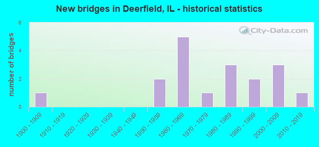
- New bridges - historical statistics
- 11900-1909
- 21950-1959
- 51960-1969
- 11970-1979
- 31980-1989
- 21990-1999
- 32000-2009
- 12010-2019

- Reconstructed bridges - Historical Statistics
- 11980-1989
- 01990-1999
- 52000-2009
- 12010-2019


- Bridge Condition - Deck
- 7.7%Very good
- 53.8%Good
- 15.4%Satisfactory
- 23.1%Fair

- Bridge Condition - Superstructure
- 15.4%Very good
- 23.1%Good
- 30.8%Satisfactory
- 30.8%Fair

- Bridge Condition - Substructure
- 15.4%Very good
- 76.9%Good
- 7.7%Fair

- Bridge Condition - Channel
- 30.0%Very good
- 40.0%Good
- 30.0%Satisfactory
Find on map >> Show street view
Structure Number: 160305, Location: 0.5 M N IL 68 (Lat: 42.144994, Lng: -87.830222), Route carried "on" structure: State highway 43, Year Built: 1958, Year Reconstructed: 2006, Status: Open, Structure Length: 9.20m (30.18ft), Average Daily Traffic: 21,300 (year 2021), Truck Traffic: 4%, Average Future Daily Traffic: 26,883 (year 2032), Design Load: HS 20, Features Intersected: I- 94 EDENS SPUR
Minimum Vertical Clearance: 30+ m (98+ ft), Kilometerpoint: 72.579, Lanes on structure: 4, Lanes under structure: 4, Base Highway Network: Yes, Owner: State Highway Agency, Approaching Roadway Width: 21.9m (71.9ft), Skew: 34 degrees, Material/Design: Prestressed concrete, Design/Construction: Stringer/Multi-beam, Number Of Spans In Main Unit: 4, Length of Maximum Span: 27.7m (90.9ft), Curb or Sidewalk Widths: Left: 2.1m (6.9ft), Right: 0.0m, Curb-To-Curb Width: 17.4m (57.1ft), Out-to-Out Width: 25.4m (83.3ft)
Condition: Deck: Good, Superstructure: Fair, Substructure: Fair, Operating Rating: 69.3 metric tons, Method Used To Determine Operating Rating: Load Factor (LF) rating reported by rating factor (RF) method using MS18 loading, Inventory Rating: 41.5 metric tons, Method Used To Determine Inventory Rating: Load Factor (LF) rating reported by rating factor (RF) method using MS18 loading, Structural Evaluation: Somewhat better than minimum adequacy, Deck Geometry: Somewhat better than minimum adequacy, Underclear: Meets minimum limits, Approach Roadway Alignment: Equal to present desirable criteria, Designated Inspection Frequency: Every 24 months, Inspection Date: June 2019, Deck Structure Type: Concrete Cast-file-Place, Wearing Surface/Protective System: Deck Protection: Epoxy Coated Reinforcing
Find on map >> Show street view
Structure Number: 161199, Location: 2 Mi W of Ill 43 (Lat: 42.152850, Lng: -87.872161), Route carried "on" structure: Other road , Year Built: 2008, Status: Open, Structure Length: 3.29m (10.79ft), Average Daily Traffic: 34,700 (year 2018), Truck Traffic: 3%, Average Future Daily Traffic: 17,350 (year 2032), Design Load: HS 25 or greater, Features Intersected: I-294 NB, Facility Carried by Structure: Lake Cook Rd
Minimum Vertical Clearance: 30+ m (98+ ft), Kilometerpoint: 13.937, Lanes on structure: 8, Lanes under structure: 4, Base Highway Network: Yes, Toll: On toll road, Owner: County Highway Agency, Approaching Roadway Width: 32.3m (106.0ft), Skew: 31 degrees, Material/Design: Steel, Design/Construction: Stringer/Multi-beam, Number Of Spans In Main Unit: 1, Length of Maximum Span: 32.0m (105.0ft), Curb or Sidewalk Widths: Left: 1.5m (4.9ft), Right: 1.5m (4.9ft), Curb-To-Curb Width: 32.3m (106.0ft), Out-to-Out Width: 36.0m (118.1ft)
Condition: Deck: Good, Superstructure: Very good, Substructure: Good, Operating Rating: 97.2 metric tons, Method Used To Determine Operating Rating: Load Factor (LF) rating reported by rating factor (RF) method using MS18 loading, Inventory Rating: 64.5 metric tons, Method Used To Determine Inventory Rating: Load Factor (LF) rating reported by rating factor (RF) method using MS18 loading, Structural Evaluation: Better than present minimum criteria, Deck Geometry: Somewhat better than minimum adequacy, Approach Roadway Alignment: Meets minimum limits, Designated Inspection Frequency: Every 24 months, Inspection Date: June 2019, Deck Structure Type: Concrete Cast-file-Place
Find on map >> Show street view
Structure Number: 168296, Location: 200FT S LAKE COOK RD (Lat: 42.152475, Lng: -87.848200), Route carried "on" structure: Other road , Year Built: 1988, Status: Open, Structure Length: 2.70m (8.86ft), Average Daily Traffic: 14,900 (year 2018), Truck Traffic: 4%, Average Future Daily Traffic: 16,583 (year 2032), Design Load: HS 20, Features Intersected: NO BR CHICAGO RIVER, Facility Carried by Structure: PFINGSTEN ROAD
Minimum Vertical Clearance: 30+ m (98+ ft), Kilometerpoint: 0.032, Lanes on structure: 5, Base Highway Network: Yes, Owner: City or Municipal Highway Agency, Approaching Roadway Width: 19.5m (64.0ft), Skew: 20 degrees, Material/Design: Concrete continuous, Design/Construction: Slab, Number Of Spans In Main Unit: 3, Length of Maximum Span: 10.1m (33.1ft), Curb or Sidewalk Widths: Left: 1.5m (4.9ft), Right: 1.5m (4.9ft), Curb-To-Curb Width: 19.5m (64.0ft), Out-to-Out Width: 24.4m (80.1ft)
Condition: Deck: Good, Superstructure: Good, Substructure: Good, Channel: Good, Operating Rating: 44.1 metric tons, Method Used To Determine Operating Rating: Assigned rating based on Load Factor Design (LFD) reported by rating factor (RF) using MS18 loading, Inventory Rating: 32.4 metric tons, Method Used To Determine Inventory Rating: Assigned rating based on Load Factor Design (LFD) reported by rating factor (RF) using MS18 loading, Structural Evaluation: Better than present minimum criteria, Deck Geometry: Meets minimum limits, Waterway Adequacy: Equal to present desirable criteria, Approach Roadway Alignment: Equal to present desirable criteria, Designated Inspection Frequency: Every 48 months, Inspection Date: March 2021, Deck Structure Type: Concrete Cast-file-Place, Wearing Surface/Protective System: Deck Protection: Epoxy Coated Reinforcing
Find on map >> Show street view
Structure Number: 490071, Location: 0.9 MI W OF IL 41 (Lat: 42.167414, Lng: -87.829264), Route carried "on" structure: Other road , Year Built: 1962, Year Reconstructed: 2000, Status: Open, Structure Length: 1.46m (4.79ft), Average Daily Traffic: 24,400 (year 2019), Truck Traffic: 3%, Average Future Daily Traffic: 24,931 (year 2032), Design Load: HS 20, Features Intersected: M F N BR CHICAGO RIV, Facility Carried by Structure: DEERFIELD ROAD
Minimum Vertical Clearance: 30+ m (98+ ft), Kilometerpoint: 12.182, Lanes on structure: 4, Base Highway Network: Yes, Owner: County Highway Agency, Approaching Roadway Width: 15.9m (52.2ft), Skew: 1 degrees, Material/Design: Prestressed concrete, Design/Construction: Box Beam or Girders - Multiple, Number Of Spans In Main Unit: 1, Length of Maximum Span: 13.7m (44.9ft), Curb or Sidewalk Widths: Left: 1.5m (4.9ft), Right: 1.5m (4.9ft), Curb-To-Curb Width: 15.9m (52.2ft), Out-to-Out Width: 19.6m (64.3ft)
Condition: Deck: Fair, Superstructure: Fair, Substructure: Good, Channel: Very good, Operating Rating: 53.8 metric tons, Method Used To Determine Operating Rating: Load Factor (LF) rating reported by rating factor (RF) method using MS18 loading, Inventory Rating: 32.4 metric tons, Method Used To Determine Inventory Rating: Load Factor (LF) rating reported by rating factor (RF) method using MS18 loading, Structural Evaluation: Somewhat better than minimum adequacy, Deck Geometry: Meets minimum limits, Waterway Adequacy: Equal to present minimum criteria, Approach Roadway Alignment: Equal to present desirable criteria, Length Of Structure Improvement: 1.46m (4.79ft), Designated Inspection Frequency: Every 24 months, Inspection Date: March 2020, Bridge Improvement Cost: $144,000, Roadway Improvement Cost: $14,000, Total Project Cost: $216,000, Deck Structure Type: Concrete Precast Panels, Wearing Surface/Protective System: Wearing Surface: Bituminous, Membrane: Built-up
Find on map >> Show street view
Structure Number: 496003, Location: .2 MI W OF WAUKEGAN (Lat: 42.157928, Lng: -87.844250), Route carried "on" structure: Other road , Year Built: 1987, Year Reconstructed: 2017, Status: Open, Structure Length: 3.31m (10.86ft), Average Daily Traffic: 11,800 (year 2019), Truck Traffic: 7%, Average Future Daily Traffic: 13,125 (year 2032), Design Load: HS 25 or greater, Features Intersected: CANADIAN PACIFIC RR, Facility Carried by Structure: PFINGSTEN RD
Minimum Vertical Clearance: 30+ m (98+ ft), Kilometerpoint: 0.418, Lanes on structure: 2, Owner: City or Municipal Highway Agency, Approaching Roadway Width: 9.1m (29.9ft), Skew: 9 degrees, Material/Design: Prestressed concrete, Design/Construction: Stringer/Multi-beam, Number Of Spans In Main Unit: 1, Length of Maximum Span: 31.9m (104.7ft), Curb or Sidewalk Widths: Left: 1.5m (4.9ft), Right: 0.0m, Curb-To-Curb Width: 9.1m (29.9ft), Out-to-Out Width: 11.5m (37.7ft)
Condition: Deck: Very good, Superstructure: Very good, Substructure: Good, Operating Rating: 67.4 metric tons, Method Used To Determine Operating Rating: Load and Resistance Factor Rating (LRFR) rating reported by rating factor(RF) method using HL-93 loadings, Inventory Rating: 42.8 metric tons, Method Used To Determine Inventory Rating: Load and Resistance Factor Rating (LRFR) rating reported by rating factor(RF) method using HL-93 loadings, Structural Evaluation: Better than present minimum criteria, Deck Geometry: High priority of corrective action, Underclear: Superior to present desirable criteria, Approach Roadway Alignment: Equal to present desirable criteria, Designated Inspection Frequency: Every 24 months, Inspection Date: Febuary 2020, Deck Structure Type: Concrete Cast-file-Place, Wearing Surface/Protective System: Deck Protection: Epoxy Coated Reinforcing
Find on map >> Show street view
Structure Number: 49615, Location: .3 M E 94 1.5 M S 22 (Lat: 42.178314, Lng: -87.873325), Route carried "on" structure: County highway , Year Built: 1965, Year Reconstructed: 1993, Status: Open, Structure Length: 1.48m (4.86ft), Average Daily Traffic: 20 (year 2015), Truck Traffic: 10%, Average Future Daily Traffic: 344 (year 2032), Design Load: HS 20, Features Intersected: W FK N BR CHGO RIVER, Facility Carried by Structure: MONTGOMERY RD
Minimum Vertical Clearance: 30+ m (98+ ft), Kilometerpoint: 0.418, Lanes on structure: 2, Owner: City or Municipal Highway Agency, Approaching Roadway Width: 7.9m (25.9ft), Skew: 2 degrees, Material/Design: Prestressed concrete, Design/Construction: Box Beam or Girders - Multiple, Number Of Spans In Main Unit: 1, Length of Maximum Span: 14.2m (46.6ft), Curb or Sidewalk Widths: Left: 1.4m (4.6ft), Right: 1.4m (4.6ft), Curb-To-Curb Width: 8.1m (26.6ft), Out-to-Out Width: 11.0m (36.1ft)
Condition: Deck: Fair, Superstructure: Fair, Substructure: Good, Channel: Good, Operating Rating: 92.0 metric tons, Method Used To Determine Operating Rating: Load Factor (LF) rating reported by rating factor (RF) method using MS18 loading, Inventory Rating: 55.1 metric tons, Method Used To Determine Inventory Rating: Load Factor (LF) rating reported by rating factor (RF) method using MS18 loading, Structural Evaluation: Somewhat better than minimum adequacy, Deck Geometry: Equal to present minimum criteria, Waterway Adequacy: Equal to present desirable criteria, Approach Roadway Alignment: Equal to present minimum criteria, Designated Inspection Frequency: Every 24 months, Other Special Inspection Frequency: Every 24 months, Inspection Date: March 2021, Other Special Inspection Date: March 2021, Deck Structure Type: Concrete Precast Panels, Wearing Surface/Protective System: Wearing Surface: Bituminous
Find on map >> Show street view
Structure Number: 496151, Location: .3 M E 94 1.8 M S 22 (Lat: 42.174469, Lng: -87.866989), Route carried "on" structure: Other road , Year Built: 1963, Year Reconstructed: 2009, Status: Open, Structure Length: 1.03m (3.38ft), Average Daily Traffic: 4,100 (year 2019), Truck Traffic: 4%, Average Future Daily Traffic: 5,342 (year 2032), Design Load: HS 20, Features Intersected: W FK N BR CHGO RIVER, Facility Carried by Structure: WILMOT RD
Minimum Vertical Clearance: 30+ m (98+ ft), Kilometerpoint: 2.124, Lanes on structure: 2, Owner: City or Municipal Highway Agency, Approaching Roadway Width: 8.5m (27.9ft), Material/Design: Prestressed concrete, Design/Construction: Box Beam or Girders - Multiple, Number Of Spans In Main Unit: 1, Length of Maximum Span: 9.7m (31.8ft), Curb or Sidewalk Widths: Left: 1.6m (5.2ft), Right: 1.6m (5.2ft), Curb-To-Curb Width: 9.8m (32.2ft), Out-to-Out Width: 13.6m (44.6ft)
Condition: Deck: Satisfactory, Superstructure: Satisfactory, Substructure: Good, Channel: Satisfactory, Operating Rating: 79.7 metric tons, Method Used To Determine Operating Rating: Load Factor (LF) rating reported by rating factor (RF) method using MS18 loading, Inventory Rating: 47.6 metric tons, Method Used To Determine Inventory Rating: Load Factor (LF) rating reported by rating factor (RF) method using MS18 loading, Structural Evaluation: Equal to present minimum criteria, Deck Geometry: Meets minimum limits, Waterway Adequacy: Equal to present desirable criteria, Approach Roadway Alignment: Equal to present desirable criteria, Designated Inspection Frequency: Every 24 months, Other Special Inspection Frequency: Every 24 months, Inspection Date: Febuary 2021, Other Special Inspection Date: Febuary 2021, Deck Structure Type: Concrete Precast Panels, Wearing Surface/Protective System: Wearing Surface: Other, Deck Protection: Epoxy Coated Reinforcing
Find on map >> Show street view
Structure Number: 496152, Location: .4 M E 94 1.9 M S 22 (Lat: 42.171031, Lng: -87.863953), Route carried "on" structure: Other road , Year Built: 1968, Year Reconstructed: 2009, Status: Open, Structure Length: 1.53m (5.02ft), Average Daily Traffic: 2,250 (year 2019), Truck Traffic: 4%, Average Future Daily Traffic: 4,563 (year 2032), Design Load: HS 20, Features Intersected: W FK N BR CHGO RIV, Facility Carried by Structure: HAZEL STREET
Minimum Vertical Clearance: 30+ m (98+ ft), Kilometerpoint: 0.241, Lanes on structure: 2, Owner: City or Municipal Highway Agency, Approaching Roadway Width: 7.3m (24.0ft), Skew: 4 degrees, Material/Design: Prestressed concrete, Design/Construction: Box Beam or Girders - Multiple, Number Of Spans In Main Unit: 1, Length of Maximum Span: 13.9m (45.6ft), Curb or Sidewalk Widths: Left: 1.5m (4.9ft), Right: 1.5m (4.9ft), Curb-To-Curb Width: 7.3m (24.0ft), Out-to-Out Width: 11.0m (36.1ft)
Condition: Deck: Good, Superstructure: Satisfactory, Substructure: Good, Channel: Good, Operating Rating: 75.5 metric tons, Method Used To Determine Operating Rating: Load Factor (LF) rating reported by rating factor (RF) method using MS18 loading, Inventory Rating: 44.7 metric tons, Method Used To Determine Inventory Rating: Load Factor (LF) rating reported by rating factor (RF) method using MS18 loading, Structural Evaluation: Equal to present minimum criteria, Deck Geometry: High priority of replacement, Waterway Adequacy: Equal to present desirable criteria, Approach Roadway Alignment: Equal to present desirable criteria, Length Of Structure Improvement: 2.29m (7.51ft), Designated Inspection Frequency: Every 24 months, Other Special Inspection Frequency: Every 24 months, Inspection Date: Febuary 2021, Other Special Inspection Date: Febuary 2021, Bridge Improvement Cost: $158,000, Roadway Improvement Cost: $16,000, Total Project Cost: $237,000, Deck Structure Type: Concrete Precast Panels, Wearing Surface/Protective System: Wearing Surface: Other, Deck Protection: Epoxy Coated Reinforcing
Find on map >> Show street view
Structure Number: 496153, Location: .7 M E 94 2.1 M S 22 (Lat: 42.170064, Lng: -87.861378), Route carried "on" structure: City street , Year Built: 1965, Year Reconstructed: 2011, Status: Open, Structure Length: 1.08m (3.54ft), Average Daily Traffic: 125 (year 2019), Truck Traffic: 8%, Average Future Daily Traffic: 344 (year 2032), Design Load: HS 20, Features Intersected: W FRK N BR CHGO RIV, Facility Carried by Structure: JUNIPER CT
Minimum Vertical Clearance: 30+ m (98+ ft), Kilometerpoint: 0.113, Lanes on structure: 2, Owner: City or Municipal Highway Agency, Approaching Roadway Width: 7.9m (25.9ft), Skew: 1 degrees, Material/Design: Prestressed concrete, Design/Construction: Box Beam or Girders - Multiple, Number Of Spans In Main Unit: 1, Length of Maximum Span: 10.1m (33.1ft), Curb or Sidewalk Widths: Left: 1.2m (3.9ft), Right: 1.2m (3.9ft), Curb-To-Curb Width: 7.9m (25.9ft), Out-to-Out Width: 11.0m (36.1ft)
Condition: Deck: Good, Superstructure: Satisfactory, Substructure: Very good, Channel: Satisfactory, Operating Rating: 44.1 metric tons, Method Used To Determine Operating Rating: Load Factor (LF) rating reported by rating factor (RF) method using MS18 loading, Inventory Rating: 32.4 metric tons, Method Used To Determine Inventory Rating: Load Factor (LF) rating reported by rating factor (RF) method using MS18 loading, Structural Evaluation: Equal to present minimum criteria, Deck Geometry: Somewhat better than minimum adequacy, Waterway Adequacy: Equal to present desirable criteria, Approach Roadway Alignment: Equal to present desirable criteria, Designated Inspection Frequency: Every 24 months, Other Special Inspection Frequency: Every 24 months, Inspection Date: Febuary 2021, Other Special Inspection Date: Febuary 2021, Deck Structure Type: Concrete Precast Panels, Wearing Surface/Protective System: Wearing Surface: Integral Concrete, Deck Protection: Epoxy Coated Reinforcing
Find on map >> Show street view
Structure Number: 496155, Location: .8 M E 43 2.5 M S 22 (Lat: 42.158828, Lng: -87.825969), Route carried "on" structure: City street , Year Built: 1977, Status: Open, Structure Length: 1.22m (4.00ft), Average Daily Traffic: 200 (year 2019), Truck Traffic: 15%, Average Future Daily Traffic: 344 (year 2032), Design Load: HS 20, Features Intersected: MD FRK N BR CHGO RIV, Facility Carried by Structure: CARRIAGE WAY
Minimum Vertical Clearance: 30+ m (98+ ft), Kilometerpoint: 1.127, Lanes on structure: 2, Owner: City or Municipal Highway Agency, Approaching Roadway Width: 8.2m (26.9ft), Material/Design: Concrete, Design/Construction: Culvert, Number Of Spans In Main Unit: 3, Length of Maximum Span: 4.0m (13.1ft), Curb or Sidewalk Widths: Left: 1.2m (3.9ft), Right: 1.2m (3.9ft), Curb-To-Curb Width: 8.2m (26.9ft), Out-to-Out Width: 11.0m (36.1ft)
Condition: Channel: Satisfactory, Culverts: Fair, Operating Rating: 53.8 metric tons, Method Used To Determine Operating Rating: Assigned rating based on Load Factor Design (LFD) reported by rating factor (RF) using MS18 loading, Inventory Rating: 32.4 metric tons, Method Used To Determine Inventory Rating: Assigned rating based on Load Factor Design (LFD) reported by rating factor (RF) using MS18 loading, Structural Evaluation: Somewhat better than minimum adequacy, Deck Geometry: Somewhat better than minimum adequacy, Waterway Adequacy: Equal to present desirable criteria, Approach Roadway Alignment: Equal to present desirable criteria, Designated Inspection Frequency: Every 24 months, Inspection Date: March 2021, Deck Structure Type: Concrete Cast-file-Place
Find on map >> Show street view
Structure Number: 496156, Location: 0.1 EAST OF PINE ST (Lat: 42.152781, Lng: -87.852572), Route carried "on" structure: Other road , Year Built: 1989, Status: Open, Structure Length: 3.17m (10.40ft), Average Daily Traffic: 34,700 (year 2018), Truck Traffic: 3%, Average Future Daily Traffic: 40,994 (year 2032), Design Load: HS 20, Features Intersected: W F N BR CHICAGO RIV, Facility Carried by Structure: LAKE COOK ROAD
Minimum Vertical Clearance: 30+ m (98+ ft), Kilometerpoint: 15.546, Lanes on structure: 4, Base Highway Network: Yes, Owner: City or Municipal Highway Agency, Approaching Roadway Width: 20.7m (67.9ft), Skew: 30 degrees, Material/Design: Concrete continuous, Design/Construction: Slab, Number Of Spans In Main Unit: 3, Length of Maximum Span: 12.3m (40.4ft), Curb or Sidewalk Widths: Left: 5.2m (17.1ft), Right: 5.2m (17.1ft), Curb-To-Curb Width: 20.7m (67.9ft), Out-to-Out Width: 31.7m (104.0ft)
Condition: Deck: Satisfactory, Superstructure: Satisfactory, Substructure: Good, Channel: Very good, Operating Rating: 46.3 metric tons, Method Used To Determine Operating Rating: Load Factor (LF) rating reported by rating factor (RF) method using MS18 loading, Inventory Rating: 27.5 metric tons, Method Used To Determine Inventory Rating: Load Factor (LF) rating reported by rating factor (RF) method using MS18 loading, Structural Evaluation: Equal to present minimum criteria, Deck Geometry: Superior to present desirable criteria, Waterway Adequacy: Equal to present desirable criteria, Approach Roadway Alignment: Equal to present desirable criteria, Designated Inspection Frequency: Every 24 months, Inspection Date: March 2021, Deck Structure Type: Concrete Cast-file-Place, Wearing Surface/Protective System: Deck Protection: Epoxy Coated Reinforcing
Find on map >> Show street view
Structure Number: 496157, Location: 0.6 MI W OF IL 43 (Lat: 42.167386, Lng: -87.856936), Route carried "on" structure: Other road , Year Built: 1994, Status: Open, Structure Length: 1.01m (3.31ft), Average Daily Traffic: 19,900 (year 2019), Truck Traffic: 4%, Average Future Daily Traffic: 19,478 (year 2032), Design Load: HS 20, Features Intersected: NB CHICAGO RIVER, Facility Carried by Structure: DEERFIELD ROAD
Minimum Vertical Clearance: 30+ m (98+ ft), Kilometerpoint: 9.865, Lanes on structure: 2, Base Highway Network: Yes, Owner: City or Municipal Highway Agency, Approaching Roadway Width: 9.2m (30.2ft), Material/Design: Prestressed concrete, Design/Construction: Box Beam or Girders - Multiple, Number Of Spans In Main Unit: 1, Length of Maximum Span: 9.8m (32.2ft), Curb or Sidewalk Widths: Left: 2.1m (6.9ft), Right: 2.1m (6.9ft), Curb-To-Curb Width: 9.3m (30.5ft), Out-to-Out Width: 14.3m (46.9ft)
Condition: Deck: Fair, Superstructure: Fair, Substructure: Good, Channel: Good, Operating Rating: 53.8 metric tons, Method Used To Determine Operating Rating: Assigned rating based on Load Factor Design (LFD) reported by rating factor (RF) using MS18 loading, Inventory Rating: 32.4 metric tons, Method Used To Determine Inventory Rating: Assigned rating based on Load Factor Design (LFD) reported by rating factor (RF) using MS18 loading, Structural Evaluation: Somewhat better than minimum adequacy, Deck Geometry: High priority of corrective action, Waterway Adequacy: Better than present minimum criteria, Approach Roadway Alignment: Equal to present desirable criteria, Designated Inspection Frequency: Every 24 months, Other Special Inspection Frequency: Every 24 months, Inspection Date: March 2021, Other Special Inspection Date: March 2021, Deck Structure Type: Concrete Precast Panels, Wearing Surface/Protective System: Wearing Surface: Bituminous, Membrane: Built-up
Find on map >> Show street view
Structure Number: 496161, Location: .9 M E 94 2.3 M S 22 (Lat: 42.163756, Lng: -87.856461), Route carried "on" structure: City street , Year Built: 2011, Status: Open, Structure Length: 1.58m (5.18ft), Average Daily Traffic: 2,050 (year 2019), Truck Traffic: 4%, Average Future Daily Traffic: 334 (year 2032), Design Load: HS 25 or greater, Features Intersected: W FRK N BR CHGO RIV, Facility Carried by Structure: CENTRAL STREET
Minimum Vertical Clearance: 30+ m (98+ ft), Kilometerpoint: 1.416, Lanes on structure: 2, Owner: City or Municipal Highway Agency, Approaching Roadway Width: 8.5m (27.9ft), Material/Design: Prestressed concrete, Design/Construction: Box Beam or Girders - Multiple, Number Of Spans In Main Unit: 1, Length of Maximum Span: 14.9m (48.9ft), Curb or Sidewalk Widths: Left: 1.5m (4.9ft), Right: 1.5m (4.9ft), Curb-To-Curb Width: 8.5m (27.9ft), Out-to-Out Width: 12.2m (40.0ft)
Condition: Deck: Good, Superstructure: Good, Substructure: Very good, Channel: Very good, Operating Rating: 42.1 metric tons, Method Used To Determine Operating Rating: Assigned ratings based on Load and Resistance Factor Design (LRFD) reported by rating factor (RF) using HL93 loadings, Inventory Rating: 32.4 metric tons, Method Used To Determine Inventory Rating: Assigned ratings based on Load and Resistance Factor Design (LRFD) reported by rating factor (RF) using HL93 loadings, Structural Evaluation: Better than present minimum criteria, Deck Geometry: Meets minimum limits, Waterway Adequacy: Equal to present desirable criteria, Approach Roadway Alignment: Equal to present desirable criteria, Designated Inspection Frequency: Every 48 months, Inspection Date: March 2021, Deck Structure Type: Concrete Precast Panels, Wearing Surface/Protective System: Wearing Surface: Integral Concrete, Deck Protection: Epoxy Coated Reinforcing
Find on map >> Show street view
Structure Number: 499929, Location: 1/3 MI S LAKE COOK (Lat: 42.155150, Lng: -87.874469), Route carried "on" structure: Interstate 294, Year Built: 2001, Status: Open, Structure Length: 1.10m (3.61ft), Average Daily Traffic: 52,600 (year 2020), Truck Traffic: 10%, Average Future Daily Traffic: 70,063 (year 2032), Design Load: HS 20, Features Intersected: DEERFIELD RD/RMP F
Minimum Vertical Clearance: 30+ m (98+ ft), Kilometerpoint: 0.048, Lanes on structure: 5, Lanes under structure: 1, Base Highway Network: Yes, Toll: On toll road, Owner: State Toll Authority, Approaching Roadway Width: 18.3m (60.0ft), Material/Design: Prestressed concrete, Design/Construction: Box Beam or Girders - Multiple, Number Of Spans In Main Unit: 1, Length of Maximum Span: 10.8m (35.4ft), Curb-To-Curb Width: 11.0m (36.1ft), Out-to-Out Width: 178.3m (585.0ft)
Condition: Deck: Good, Superstructure: Good, Substructure: Good, Operating Rating: 63.2 metric tons, Method Used To Determine Operating Rating: Load Factor (LF), Inventory Rating: 35.6 metric tons, Method Used To Determine Inventory Rating: Load Factor (LF), Structural Evaluation: Better than present minimum criteria, Deck Geometry: High priority of replacement, Approach Roadway Alignment: Equal to present desirable criteria, Designated Inspection Frequency: Every 24 months, Inspection Date: June 2020, Deck Structure Type: Concrete Precast Panels
Find on map >> Show street view
Structure Number: 160305, Location: 0.5 M N IL 68 (Lat: 42.144461, Lng: -87.829869), Route carried "under" structure: Interstate 94, Year Built: 1958, Structure Length: 0. m, Average Daily Traffic: 28,300 (year 2020), Truck Traffic: 18%, Features Intersected: I- 94 EDENS SPUR, Facility Carried by Structure: IL 43 (WAUKEGAN R
Minimum Vertical Clearance: 4.65m (15.26ft), Kilometerpoint: 44.803, Lanes on structure: 4, Lanes under structure: 4, Material/Design: Prestressed concrete, Design/Construction: Stringer/Multi-beam, Length of Maximum Span: 27.7m (90.9ft)
Find on map >> Show street view
Structure Number: 163228, Location: 0.30 MI W IL-43 (Lat: 42.152717, Lng: -87.842728), Route carried "under" structure: Other road , Year Built: 1997, Structure Length: 0. m, Average Daily Traffic: 32,600 (year 2018), Truck Traffic: 4%, Features Intersected: LAKE-COOK RD, Facility Carried by Structure: SOO LINE (METRA) R
Minimum Vertical Clearance: 4.50m (14.76ft), Kilometerpoint: 16.431, Lanes under structure: 5, Material/Design: Steel, Design/Construction: Girder and Floorbeam System, Length of Maximum Span: 18.9m (62.0ft)
Find on map >> Show street view
Structure Number: 499929, Location: 1/3 MI S LAKE COOK (Lat: 42.157453, Lng: -87.873783), Route carried "under" structure: Other road , Year Built: 2001, Structure Length: 0. m, Average Daily Traffic: 1,000 (year 2021), Truck Traffic: 49%, Features Intersected: DEERFIELD RD/RMP F, Facility Carried by Structure: TRI-STATE I-294
Minimum Vertical Clearance: 4.88m (16.01ft), Kilometerpoint: 0.483, Lanes on structure: 5, Lanes under structure: 1, Toll: On toll road, Material/Design: Prestressed concrete, Design/Construction: Box Beam or Girders - Multiple, Length of Maximum Span: 10.8m (35.4ft)
Find on map >> Show street view
Structure Number: 499941, Location: 1.2 M E OF I-94 (Lat: 42.167322, Lng: -87.849569), Route carried "under" structure: Other road , Year Built: 1900, Structure Length: 0. m, Average Daily Traffic: 19,900 (year 2019), Truck Traffic: 4%, Features Intersected: DEERFIELD ROAD, Facility Carried by Structure: SOO (WICT) AMTK.RR
Minimum Vertical Clearance: 3.58m (11.75ft), Kilometerpoint: 10.477, Lanes under structure: 2, Material/Design: Concrete, Design/Construction: Slab, Length of Maximum Span: 10.1m (33.1ft)