Bridge Statistics for Divernon, Illinois (IL)
Condition, Traffic, Stress, Structural Evaluation, Project Costs
- National Bridge Inventory (NBI) Statistics
- 32Number of bridges
- 325ft / 98.7mTotal length
- $477,000Total costs
- 248,500Total average daily traffic
- 62,580Total average daily truck traffic
- National Bridge Inventory (NBI) Registered Bridges for Divernon
- No street view available for this location
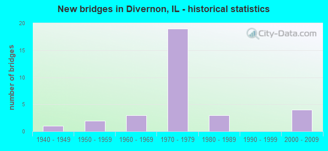
- New bridges - historical statistics
- 11940-1949
- 21950-1959
- 31960-1969
- 191970-1979
- 31980-1989
- 42000-2009

- Reconstructed bridges - Historical Statistics
- 31970-1979
- 11980-1989
- 11990-1999
- 12000-2009


- Bridge Condition - Deck
- 9.1%Very good
- 45.5%Good
- 40.9%Satisfactory
- 4.5%Fair

- Bridge Condition - Superstructure
- 13.6%Very good
- 36.4%Good
- 36.4%Satisfactory
- 4.5%Fair
- 9.1%Poor

- Bridge Condition - Substructure
- 18.2%Very good
- 54.5%Good
- 18.2%Satisfactory
- 9.1%Fair

- Bridge Condition - Channel
- 10.5%Very good
- 26.3%Good
- 47.4%Satisfactory
- 10.5%Fair
- 5.3%Serious

- Bridge Condition - Culverts
- 50.0%Good
- 50.0%Satisfactory
Find on map >> Show street view
Structure Number: 680105, Location: SANG/MONT CO LINE (Lat: 39.524017, Lng: -89.646361), Route carried "on" structure: County highway , Year Built: 1971, Status: Open, Structure Length: 10.85m (35.60ft), Average Daily Traffic: 125 (year 2020), Truck Traffic: 23%, Average Future Daily Traffic: 186 (year 2032), Design Load: HS 15, Features Intersected: I-55, Facility Carried by Structure: TR 1
Minimum Vertical Clearance: 30+ m (98+ ft), Kilometerpoint: 4.764, Lanes on structure: 2, Lanes under structure: 12, Owner: State Highway Agency, Approaching Roadway Width: 9.1m (29.9ft), Material/Design: Steel continuous, Design/Construction: Stringer/Multi-beam, Number Of Spans In Main Unit: 3, Number Of Approach Spans: 2, Length of Maximum Span: 30.4m (99.7ft), Curb-To-Curb Width: 8.1m (26.6ft), Out-to-Out Width: 9.1m (29.9ft)
Condition: Deck: Satisfactory, Superstructure: Satisfactory, Substructure: Good, Operating Rating: 73.5 metric tons, Method Used To Determine Operating Rating: Load Factor (LF) rating reported by rating factor (RF) method using MS18 loading, Inventory Rating: 44.1 metric tons, Method Used To Determine Inventory Rating: Load Factor (LF) rating reported by rating factor (RF) method using MS18 loading, Structural Evaluation: Equal to present minimum criteria, Deck Geometry: Somewhat better than minimum adequacy, Underclear: Better than present minimum criteria, Approach Roadway Alignment: Equal to present desirable criteria, Designated Inspection Frequency: Every 24 months, Inspection Date: November 2020, Deck Structure Type: Concrete Cast-file-Place, Wearing Surface/Protective System: Wearing Surface: Other
Find on map >> Show street view
Structure Number: 682012, Location: 1.2M S SANG CO LINE (Lat: 39.506494, Lng: -89.645122), Route carried "on" structure: Interstate 55, Year Built: 1972, Status: Open, Structure Length: 1.27m (4.17ft), Average Daily Traffic: 30,550 (year 2021), Truck Traffic: 27%, Average Future Daily Traffic: 30,797 (year 2032), Design Load: HS 20+Mod, Features Intersected: HORSE CREEK
Minimum Vertical Clearance: 30+ m (98+ ft), Kilometerpoint: 121.856, Lanes on structure: 8, Base Highway Network: Yes, Owner: State Highway Agency, Approaching Roadway Width: 21.9m (71.9ft), Material/Design: Concrete, Design/Construction: Culvert, Number Of Spans In Main Unit: 3, Length of Maximum Span: 3.9m (12.8ft)
Condition: Channel: Good, Culverts: Satisfactory, Operating Rating: 76.8 metric tons, Method Used To Determine Operating Rating: Load Factor (LF) rating reported by rating factor (RF) method using MS18 loading, Inventory Rating: 46.0 metric tons, Method Used To Determine Inventory Rating: Load Factor (LF) rating reported by rating factor (RF) method using MS18 loading, Structural Evaluation: Equal to present minimum criteria, Waterway Adequacy: Superior to present desirable criteria, Approach Roadway Alignment: Equal to present desirable criteria, Designated Inspection Frequency: Every 24 months, Inspection Date: July 2021
Find on map >> Show street view
Structure Number: 683338, Location: 6 MI NE FARMERSVILLE (Lat: 39.524411, Lng: -89.609722), Route carried "on" structure: County highway , Year Built: 2002, Status: Open, Structure Length: 2.98m (9.78ft), Average Daily Traffic: 75 (year 2020), Truck Traffic: 31%, Average Future Daily Traffic: 80 (year 2032), Design Load: HS 20, Features Intersected: CREEK, Facility Carried by Structure: TR-1
Minimum Vertical Clearance: 30+ m (98+ ft), Kilometerpoint: 7.918, Lanes on structure: 2, Owner: Town or Township Highway Agency, Approaching Roadway Width: 6.1m (20.0ft), Material/Design: Prestressed concrete, Design/Construction: Box Beam or Girders - Multiple, Number Of Spans In Main Unit: 3, Length of Maximum Span: 12.8m (42.0ft), Curb-To-Curb Width: 8.2m (26.9ft), Out-to-Out Width: 8.2m (26.9ft)
Condition: Deck: Satisfactory, Superstructure: Good, Substructure: Very good, Channel: Satisfactory, Operating Rating: 44.1 metric tons, Method Used To Determine Operating Rating: Assigned rating based on Load Factor Design (LFD) reported by rating factor (RF) using MS18 loading, Inventory Rating: 32.4 metric tons, Method Used To Determine Inventory Rating: Assigned rating based on Load Factor Design (LFD) reported by rating factor (RF) using MS18 loading, Structural Evaluation: Better than present minimum criteria, Deck Geometry: Equal to present minimum criteria, Waterway Adequacy: Equal to present desirable criteria, Approach Roadway Alignment: Equal to present desirable criteria, Designated Inspection Frequency: Every 48 months, Inspection Date: November 2020, Deck Structure Type: Concrete Precast Panels, Wearing Surface/Protective System: Wearing Surface: Gravel
Find on map >> Show street view
Structure Number: 840002, Location: .7M S IL 104 INTCHG (Lat: 39.580150, Lng: -89.646906), Route carried "on" structure: Other road , Year Built: 1949, Status: Open, Structure Length: 2.23m (7.32ft), Average Daily Traffic: 250 (year 2021), Truck Traffic: 3%, Average Future Daily Traffic: 295 (year 2032), Design Load: HS 20, Features Intersected: BRUSH CREEK, Facility Carried by Structure: I-55 W FR (BR CR R
Minimum Vertical Clearance: 30+ m (98+ ft), Kilometerpoint: 1.738, Lanes on structure: 2, Owner: State Highway Agency, Approaching Roadway Width: 10.7m (35.1ft), Material/Design: Steel, Design/Construction: Stringer/Multi-beam, Number Of Spans In Main Unit: 1, Length of Maximum Span: 20.7m (67.9ft), Curb-To-Curb Width: 12.1m (39.7ft), Out-to-Out Width: 13.2m (43.3ft)
Condition: Deck: Fair, Superstructure: Fair, Substructure: Satisfactory, Channel: Satisfactory, Operating Rating: 56.7 metric tons, Method Used To Determine Operating Rating: Allowable Stress (AS) rating reported by rating factor (RF) method using MS18 loading, Inventory Rating: 35.3 metric tons, Method Used To Determine Inventory Rating: Allowable Stress (AS) rating reported by rating factor (RF) method using MS18 loading, Structural Evaluation: Somewhat better than minimum adequacy, Deck Geometry: Better than present minimum criteria, Waterway Adequacy: Better than present minimum criteria, Approach Roadway Alignment: Equal to present desirable criteria, Designated Inspection Frequency: Every 24 months, Inspection Date: June 2021, Deck Structure Type: Concrete Cast-file-Place
Find on map >> Show street view
Structure Number: 840065, Location: 0.90 mi E I-55 (Lat: 39.590419, Lng: -89.630014), Route carried "on" structure: State highway 104, Year Built: 1962, Year Reconstructed: 2000, Status: Open, Structure Length: 4.47m (14.67ft), Average Daily Traffic: 4,850 (year 2021), Truck Traffic: 9%, Average Future Daily Traffic: 4,288 (year 2032), Design Load: HS 20, Features Intersected: BRUSH CREEK
Minimum Vertical Clearance: 30+ m (98+ ft), Kilometerpoint: 174.899, Lanes on structure: 2, Base Highway Network: Yes, Owner: State Highway Agency, Approaching Roadway Width: 11.6m (38.1ft), Skew: 3 degrees, Material/Design: Prestressed concrete continuous, Design/Construction: Stringer/Multi-beam, Number Of Spans In Main Unit: 3, Length of Maximum Span: 14.4m (47.2ft), Curb-To-Curb Width: 12.2m (40.0ft), Out-to-Out Width: 13.2m (43.3ft)
Condition: Deck: Good, Superstructure: Very good, Substructure: Very good, Channel: Good, Operating Rating: 69.7 metric tons, Method Used To Determine Operating Rating: Load Factor (LF) rating reported by rating factor (RF) method using MS18 loading, Inventory Rating: 41.8 metric tons, Method Used To Determine Inventory Rating: Load Factor (LF) rating reported by rating factor (RF) method using MS18 loading, Structural Evaluation: Equal to present desirable criteria, Deck Geometry: Equal to present minimum criteria, Waterway Adequacy: Superior to present desirable criteria, Approach Roadway Alignment: Equal to present desirable criteria, Length Of Structure Improvement: 4.36m (14.30ft), Designated Inspection Frequency: Every 48 months, Inspection Date: January 2019, Bridge Improvement Cost: $318,000, Roadway Improvement Cost: $32,000, Total Project Cost: $477,000, Deck Structure Type: Concrete Cast-file-Place, Wearing Surface/Protective System: Deck Protection: Epoxy Coated Reinforcing
Find on map >> Show street view
Structure Number: 840106, Location: 3M N MONTGOMERY CO. (Lat: 39.567772, Lng: -89.646639), Route carried "on" structure: County highway , Year Built: 1972, Year Reconstructed: 2003, Status: Open, Structure Length: 7.63m (25.03ft), Average Daily Traffic: 2,500 (year 2021), Truck Traffic: 3%, Average Future Daily Traffic: 3,377 (year 2032), Design Load: HS 20, Features Intersected: I-55, Facility Carried by Structure: DIVERNON RD/ FAS 6
Minimum Vertical Clearance: 30+ m (98+ ft), Kilometerpoint: 9.624, Lanes on structure: 2, Lanes under structure: 4, Owner: State Highway Agency, Approaching Roadway Width: 15.8m (51.8ft), Skew: 30 degrees, Material/Design: Steel continuous, Design/Construction: Stringer/Multi-beam, Number Of Spans In Main Unit: 2, Number Of Approach Spans: 2, Length of Maximum Span: 30.2m (99.1ft), Curb-To-Curb Width: 15.7m (51.5ft), Out-to-Out Width: 21.9m (71.9ft)
Condition: Deck: Satisfactory, Superstructure: Good, Substructure: Satisfactory, Operating Rating: 54.4 metric tons, Method Used To Determine Operating Rating: Load Factor (LF) rating reported by rating factor (RF) method using MS18 loading, Inventory Rating: 32.4 metric tons, Method Used To Determine Inventory Rating: Load Factor (LF) rating reported by rating factor (RF) method using MS18 loading, Structural Evaluation: Equal to present minimum criteria, Deck Geometry: Superior to present desirable criteria, Underclear: Meets minimum limits, Approach Roadway Alignment: Equal to present desirable criteria, Designated Inspection Frequency: Every 24 months, Inspection Date: January 2022, Deck Structure Type: Concrete Cast-file-Place, Wearing Surface/Protective System: Deck Protection: Epoxy Coated Reinforcing
Find on map >> Show street view
Structure Number: 840107, Location: .7MI S IL 104 INTCHG (Lat: 39.580264, Lng: -89.646194), Route carried "on" structure: Interstate 55, Year Built: 1972, Year Reconstructed: 1979, Status: Open, Structure Length: 4.87m (15.98ft), Average Daily Traffic: 16,300 (year 2021), Truck Traffic: 27%, Average Future Daily Traffic: 15,383 (year 2032), Design Load: HS 20+Mod, Features Intersected: BRUSH CREEK
Minimum Vertical Clearance: 30+ m (98+ ft), Kilometerpoint: 129.967, Lanes on structure: 2, Base Highway Network: Yes, Owner: State Highway Agency, Approaching Roadway Width: 13.4m (44.0ft), Skew: 3 degrees, Material/Design: Steel continuous, Design/Construction: Stringer/Multi-beam, Number Of Spans In Main Unit: 3, Length of Maximum Span: 17.2m (56.4ft), Curb-To-Curb Width: 12.3m (40.4ft), Out-to-Out Width: 13.4m (44.0ft)
Condition: Deck: Good, Superstructure: Satisfactory, Substructure: Good, Channel: Satisfactory, Operating Rating: 57.0 metric tons, Method Used To Determine Operating Rating: Load Factor (LF) rating reported by rating factor (RF) method using MS18 loading, Inventory Rating: 34.0 metric tons, Method Used To Determine Inventory Rating: Load Factor (LF) rating reported by rating factor (RF) method using MS18 loading, Structural Evaluation: Equal to present minimum criteria, Deck Geometry: Better than present minimum criteria, Waterway Adequacy: Equal to present minimum criteria, Approach Roadway Alignment: Equal to present desirable criteria, Designated Inspection Frequency: Every 24 months, Inspection Date: September 2020, Deck Structure Type: Concrete Cast-file-Place, Wearing Surface/Protective System: Wearing Surface: Other, Membrane: Built-up
Find on map >> Show street view
Structure Number: 840108, Location: .7MI S IL 104 INTCHG (Lat: 39.580097, Lng: -89.646192), Route carried "on" structure: Interstate 55, Year Built: 1972, Year Reconstructed: 1979, Status: Open, Structure Length: 4.87m (15.98ft), Average Daily Traffic: 16,300 (year 2021), Truck Traffic: 27%, Average Future Daily Traffic: 15,383 (year 2032), Design Load: HS 20+Mod, Features Intersected: BRUSH CREEK
Minimum Vertical Clearance: 30+ m (98+ ft), Kilometerpoint: 129.951, Lanes on structure: 2, Base Highway Network: Yes, Owner: State Highway Agency, Approaching Roadway Width: 13.4m (44.0ft), Skew: 3 degrees, Material/Design: Steel continuous, Design/Construction: Stringer/Multi-beam, Number Of Spans In Main Unit: 3, Length of Maximum Span: 17.2m (56.4ft), Curb-To-Curb Width: 12.3m (40.4ft), Out-to-Out Width: 13.4m (44.0ft)
Condition: Deck: Good, Superstructure: Satisfactory, Substructure: Good, Channel: Satisfactory, Operating Rating: 57.0 metric tons, Method Used To Determine Operating Rating: Load Factor (LF) rating reported by rating factor (RF) method using MS18 loading, Inventory Rating: 34.0 metric tons, Method Used To Determine Inventory Rating: Load Factor (LF) rating reported by rating factor (RF) method using MS18 loading, Structural Evaluation: Equal to present minimum criteria, Deck Geometry: Better than present minimum criteria, Waterway Adequacy: Equal to present minimum criteria, Approach Roadway Alignment: Equal to present desirable criteria, Designated Inspection Frequency: Every 24 months, Inspection Date: September 2020, Deck Structure Type: Concrete Cast-file-Place, Wearing Surface/Protective System: Wearing Surface: Other, Membrane: Built-up
Find on map >> Show street view
Structure Number: 840109, Location: 1.5M N DIVERNON INT (Lat: 39.589442, Lng: -89.646408), Route carried "on" structure: Interstate 55, Year Built: 1972, Status: Open, Structure Length: 8.56m (28.08ft), Average Daily Traffic: 16,300 (year 2021), Truck Traffic: 27%, Average Future Daily Traffic: 19,028 (year 2032), Design Load: HS 20+Mod, Features Intersected: IL 104 / I & M RR
Minimum Vertical Clearance: 30+ m (98+ ft), Kilometerpoint: 131.013, Lanes on structure: 3, Lanes under structure: 2, Base Highway Network: Yes, Owner: State Highway Agency, Approaching Roadway Width: 16.5m (54.1ft), Material/Design: Steel continuous, Design/Construction: Stringer/Multi-beam, Number Of Spans In Main Unit: 2, Number Of Approach Spans: 2, Length of Maximum Span: 33.2m (108.9ft), Curb-To-Curb Width: 17.0m (55.8ft), Out-to-Out Width: 18.0m (59.1ft)
Condition: Deck: Satisfactory, Superstructure: Poor, Substructure: Good, Operating Rating: 51.8 metric tons, Method Used To Determine Operating Rating: Load Factor (LF) rating reported by rating factor (RF) method using MS18 loading, Inventory Rating: 32.4 metric tons, Method Used To Determine Inventory Rating: Load Factor (LF) rating reported by rating factor (RF) method using MS18 loading, Structural Evaluation: Meets minimum limits, Deck Geometry: Equal to present minimum criteria, Underclear: Better than present minimum criteria, Approach Roadway Alignment: Equal to present desirable criteria, Designated Inspection Frequency: Every 12 months, Inspection Date: November 2021, Deck Structure Type: Concrete Cast-file-Place, Wearing Surface/Protective System: Wearing Surface: Other, Membrane: Built-up
Find on map >> Show street view
Structure Number: 84011, Location: 1.5M N DIVERNON INT (Lat: 39.589642, Lng: -89.646408), Route carried "on" structure: Interstate 55, Year Built: 1972, Status: Open, Structure Length: 8.56m (28.08ft), Average Daily Traffic: 16,300 (year 2021), Truck Traffic: 27%, Average Future Daily Traffic: 19,028 (year 2032), Design Load: HS 20+Mod, Features Intersected: IL 104 / I & M RR
Minimum Vertical Clearance: 30+ m (98+ ft), Kilometerpoint: 131.029, Lanes on structure: 3, Lanes under structure: 2, Base Highway Network: Yes, Owner: State Highway Agency, Approaching Roadway Width: 16.5m (54.1ft), Material/Design: Steel continuous, Design/Construction: Stringer/Multi-beam, Number Of Spans In Main Unit: 2, Number Of Approach Spans: 2, Length of Maximum Span: 33.2m (108.9ft), Curb-To-Curb Width: 19.3m (63.3ft), Out-to-Out Width: 20.5m (67.3ft)
Condition: Deck: Satisfactory, Superstructure: Poor, Substructure: Satisfactory, Operating Rating: 56.7 metric tons, Method Used To Determine Operating Rating: Load Factor (LF) rating reported by rating factor (RF) method using MS18 loading, Inventory Rating: 35.3 metric tons, Method Used To Determine Inventory Rating: Load Factor (LF) rating reported by rating factor (RF) method using MS18 loading, Structural Evaluation: Meets minimum limits, Deck Geometry: Superior to present desirable criteria, Underclear: Equal to present desirable criteria, Approach Roadway Alignment: Equal to present desirable criteria, Designated Inspection Frequency: Every 12 months, Inspection Date: November 2021, Deck Structure Type: Concrete Cast-file-Place, Wearing Surface/Protective System: Wearing Surface: Other, Membrane: Built-up
Find on map >> Show street view
Structure Number: 840111, Location: 1.8M N IL 104 (Lat: 39.616056, Lng: -89.647411), Route carried "on" structure: Other road , Year Built: 1972, Year Reconstructed: 1979, Status: Open, Structure Length: 8.80m (28.87ft), Average Daily Traffic: 850 (year 2021), Truck Traffic: 5%, Average Future Daily Traffic: 536 (year 2032), Design Load: HS 20, Features Intersected: I-55, Facility Carried by Structure: HORSE FARM RD.
Minimum Vertical Clearance: 30+ m (98+ ft), Kilometerpoint: 0.756, Lanes on structure: 2, Lanes under structure: 6, Owner: State Highway Agency, Approaching Roadway Width: 18.3m (60.0ft), Skew: 32 degrees, Material/Design: Steel continuous, Design/Construction: Stringer/Multi-beam, Number Of Spans In Main Unit: 2, Number Of Approach Spans: 2, Length of Maximum Span: 33.2m (108.9ft), Curb-To-Curb Width: 13.0m (42.7ft), Out-to-Out Width: 18.9m (62.0ft)
Condition: Deck: Good, Superstructure: Good, Substructure: Satisfactory, Operating Rating: 87.8 metric tons, Method Used To Determine Operating Rating: Load Factor (LF) rating reported by rating factor (RF) method using MS18 loading, Inventory Rating: 52.8 metric tons, Method Used To Determine Inventory Rating: Load Factor (LF) rating reported by rating factor (RF) method using MS18 loading, Structural Evaluation: Equal to present minimum criteria, Deck Geometry: Superior to present desirable criteria, Underclear: Somewhat better than minimum adequacy, Approach Roadway Alignment: Equal to present desirable criteria, Designated Inspection Frequency: Every 24 months, Inspection Date: January 2022, Deck Structure Type: Concrete Cast-file-Place, Wearing Surface/Protective System: Wearing Surface: Other, Membrane: Built-up
Find on map >> Show street view
Structure Number: 84314, Location: 2.0 MI E OF DIVERNON (Lat: 39.597328, Lng: -89.630083), Route carried "on" structure: County highway , Year Built: 1971, Status: Open, Structure Length: 3.30m (10.83ft), Average Daily Traffic: 100 (year 2017), Average Future Daily Traffic: 80 (year 2032), Design Load: HS 15, Features Intersected: BRUSH CREEK, Facility Carried by Structure: TR 298
Minimum Vertical Clearance: 30+ m (98+ ft), Kilometerpoint: 1.368, Lanes on structure: 2, Owner: Town or Township Highway Agency, Approaching Roadway Width: 4.9m (16.1ft), Material/Design: Prestressed concrete, Design/Construction: Box Beam or Girders - Multiple, Number Of Spans In Main Unit: 3, Length of Maximum Span: 11.1m (36.4ft), Curb-To-Curb Width: 7.5m (24.6ft), Out-to-Out Width: 8.2m (26.9ft)
Condition: Deck: Satisfactory, Superstructure: Satisfactory, Substructure: Good, Channel: Fair, Operating Rating: 46.3 metric tons, Method Used To Determine Operating Rating: Load Factor (LF) rating reported by rating factor (RF) method using MS18 loading, Inventory Rating: 27.9 metric tons, Method Used To Determine Inventory Rating: Load Factor (LF) rating reported by rating factor (RF) method using MS18 loading, Structural Evaluation: Equal to present minimum criteria, Deck Geometry: Equal to present minimum criteria, Waterway Adequacy: Better than present minimum criteria, Approach Roadway Alignment: Better than present minimum criteria, Designated Inspection Frequency: Every 24 months, Inspection Date: March 2021, Deck Structure Type: Concrete Precast Panels, Wearing Surface/Protective System: Wearing Surface: Bituminous
Find on map >> Show street view
Structure Number: 843189, Location: 0.1 MI W DIVERNON (Lat: 39.567575, Lng: -89.660889), Route carried "on" structure: County highway , Year Built: 1953, Year Reconstructed: 1989, Status: Open, Structure Length: 1.65m (5.41ft), Average Daily Traffic: 1,550 (year 2017), Truck Traffic: 10%, Average Future Daily Traffic: 1,126 (year 2032), Design Load: HS 20, Features Intersected: BRUSH CREEK, Facility Carried by Structure: FAS 625
Minimum Vertical Clearance: 30+ m (98+ ft), Kilometerpoint: 8.401, Lanes on structure: 2, Owner: Town or Township Highway Agency, Approaching Roadway Width: 6.1m (20.0ft), Skew: 2 degrees, Material/Design: Prestressed concrete, Design/Construction: Box Beam or Girders - Multiple, Number Of Spans In Main Unit: 1, Length of Maximum Span: 15.8m (51.8ft), Curb-To-Curb Width: 8.3m (27.2ft), Out-to-Out Width: 8.3m (27.2ft)
Condition: Deck: Good, Superstructure: Good, Substructure: Good, Channel: Good, Operating Rating: 61.6 metric tons, Method Used To Determine Operating Rating: Load Factor (LF) rating reported by rating factor (RF) method using MS18 loading, Inventory Rating: 36.9 metric tons, Method Used To Determine Inventory Rating: Load Factor (LF) rating reported by rating factor (RF) method using MS18 loading, Structural Evaluation: Better than present minimum criteria, Deck Geometry: Meets minimum limits, Waterway Adequacy: Equal to present desirable criteria, Approach Roadway Alignment: Equal to present desirable criteria, Designated Inspection Frequency: Every 24 months, Inspection Date: March 2021, Deck Structure Type: Concrete Precast Panels, Wearing Surface/Protective System: Wearing Surface: Bituminous
Find on map >> Show street view
Structure Number: 843197, Location: .5 W OF DIVERNON (Lat: 39.552939, Lng: -89.665767), Route carried "on" structure: County highway , Year Built: 1965, Status: Open, Structure Length: 3.35m (10.99ft), Average Daily Traffic: 100 (year 2017), Truck Traffic: 10%, Average Future Daily Traffic: 54 (year 2032), Design Load: HS 15, Features Intersected: BRUSH CREEK, Facility Carried by Structure: TR 447 17 S
Minimum Vertical Clearance: 30+ m (98+ ft), Kilometerpoint: 6.357, Lanes on structure: 2, Owner: Town or Township Highway Agency, Approaching Roadway Width: 5.5m (18.0ft), Skew: 3 degrees, Material/Design: Concrete continuous, Design/Construction: Slab, Number Of Spans In Main Unit: 3, Length of Maximum Span: 12.8m (42.0ft), Curb-To-Curb Width: 7.3m (24.0ft), Out-to-Out Width: 8.0m (26.2ft)
Condition: Deck: Satisfactory, Superstructure: Satisfactory, Substructure: Fair, Channel: Serious, Operating Rating: 43.4 metric tons, Method Used To Determine Operating Rating: Load Factor (LF) rating reported by rating factor (RF) method using MS18 loading, Inventory Rating: 26.2 metric tons, Method Used To Determine Inventory Rating: Load Factor (LF) rating reported by rating factor (RF) method using MS18 loading, Structural Evaluation: Somewhat better than minimum adequacy, Deck Geometry: Equal to present minimum criteria, Waterway Adequacy: Better than present minimum criteria, Approach Roadway Alignment: Equal to present desirable criteria, Designated Inspection Frequency: Every 24 months, Inspection Date: March 2021, Deck Structure Type: Concrete Cast-file-Place
Find on map >> Show street view
Structure Number: 8432, Location: 2.0 SW OF DIVERNON (Lat: 39.538142, Lng: -89.689192), Route carried "on" structure: County highway , Year Built: 1956, Status: Open, Structure Length: 1.58m (5.18ft), Average Daily Traffic: 100 (year 2017), Average Future Daily Traffic: 80 (year 2032), Design Load: HS 15, Features Intersected: BRUSH CREEK, Facility Carried by Structure: TR 463 18S
Minimum Vertical Clearance: 30+ m (98+ ft), Kilometerpoint: 1.110, Lanes on structure: 2, Owner: Town or Township Highway Agency, Approaching Roadway Width: 5.5m (18.0ft), Material/Design: Steel, Design/Construction: Stringer/Multi-beam, Number Of Spans In Main Unit: 1, Length of Maximum Span: 14.9m (48.9ft), Curb-To-Curb Width: 7.3m (24.0ft), Out-to-Out Width: 8.7m (28.5ft)
Condition: Deck: Good, Superstructure: Satisfactory, Substructure: Good, Channel: Fair, Operating Rating: 45.0 metric tons, Method Used To Determine Operating Rating: Load Factor (LF) rating reported by rating factor (RF) method using MS18 loading, Inventory Rating: 27.2 metric tons, Method Used To Determine Inventory Rating: Load Factor (LF) rating reported by rating factor (RF) method using MS18 loading, Structural Evaluation: Equal to present minimum criteria, Deck Geometry: Equal to present minimum criteria, Waterway Adequacy: Equal to present desirable criteria, Approach Roadway Alignment: Equal to present desirable criteria, Designated Inspection Frequency: Every 24 months, Inspection Date: March 2021, Deck Structure Type: Concrete Cast-file-Place
Find on map >> Show street view
Structure Number: 843201, Location: 3.5 SW OF PAWNEE (Lat: 39.539039, Lng: -89.612550), Route carried "on" structure: County highway , Year Built: 1966, Status: Open, Structure Length: 3.14m (10.30ft), Average Daily Traffic: 50 (year 2017), Average Future Daily Traffic: 11 (year 2032), Design Load: HS 15, Features Intersected: WEST BRANCH, Facility Carried by Structure: TR 465 18S
Minimum Vertical Clearance: 30+ m (98+ ft), Kilometerpoint: 2.816, Lanes on structure: 2, Owner: Town or Township Highway Agency, Approaching Roadway Width: 4.3m (14.1ft), Material/Design: Concrete continuous, Design/Construction: Slab, Number Of Spans In Main Unit: 3, Length of Maximum Span: 11.6m (38.1ft), Curb-To-Curb Width: 7.3m (24.0ft), Out-to-Out Width: 7.9m (25.9ft)
Condition: Deck: Satisfactory, Superstructure: Satisfactory, Substructure: Fair, Channel: Satisfactory, Operating Rating: 48.0 metric tons, Method Used To Determine Operating Rating: Load Factor (LF) rating reported by rating factor (RF) method using MS18 loading, Inventory Rating: 28.8 metric tons, Method Used To Determine Inventory Rating: Load Factor (LF) rating reported by rating factor (RF) method using MS18 loading, Structural Evaluation: Somewhat better than minimum adequacy, Deck Geometry: Equal to present minimum criteria, Waterway Adequacy: Equal to present desirable criteria, Approach Roadway Alignment: Equal to present desirable criteria, Designated Inspection Frequency: Every 24 months, Inspection Date: Febuary 2021, Deck Structure Type: Concrete Cast-file-Place
Find on map >> Show street view
Structure Number: 843523, Location: 3.0 E OF THAYER (Lat: 39.544533, Lng: -89.683733), Route carried "on" structure: County highway , Year Built: 1979, Status: Open, Structure Length: 2.18m (7.15ft), Average Daily Traffic: 125 (year 2017), Average Future Daily Traffic: 80 (year 2032), Design Load: HS 20, Features Intersected: BRUSH CREEK, Facility Carried by Structure: TR 214
Minimum Vertical Clearance: 30+ m (98+ ft), Kilometerpoint: 1.110, Lanes on structure: 2, Owner: Town or Township Highway Agency, Approaching Roadway Width: 4.3m (14.1ft), Material/Design: Prestressed concrete, Design/Construction: Box Beam or Girders - Multiple, Number Of Spans In Main Unit: 1, Length of Maximum Span: 21.3m (69.9ft), Curb-To-Curb Width: 8.2m (26.9ft), Out-to-Out Width: 8.4m (27.6ft)
Condition: Deck: Good, Superstructure: Good, Substructure: Good, Channel: Satisfactory, Operating Rating: 44.4 metric tons, Method Used To Determine Operating Rating: Assigned rating based on Load Factor Design (LFD) reported by rating factor (RF) using MS18 loading, Inventory Rating: 32.4 metric tons, Method Used To Determine Inventory Rating: Assigned rating based on Load Factor Design (LFD) reported by rating factor (RF) using MS18 loading, Structural Evaluation: Better than present minimum criteria, Deck Geometry: Somewhat better than minimum adequacy, Waterway Adequacy: Equal to present desirable criteria, Approach Roadway Alignment: Better than present minimum criteria, Designated Inspection Frequency: Every 48 months, Inspection Date: March 2019, Deck Structure Type: Concrete Precast Panels, Wearing Surface/Protective System: Wearing Surface: Bituminous
Find on map >> Show street view
Structure Number: 843539, Location: 3.0 SW OF PAWNEE (Lat: 39.544600, Lng: -89.608481), Route carried "on" structure: County highway , Year Built: 1985, Status: Open, Structure Length: 4.39m (14.40ft), Average Daily Traffic: 50 (year 2017), Average Future Daily Traffic: 54 (year 2032), Design Load: HS 20, Features Intersected: WEST BRANCH HORSE CK, Facility Carried by Structure: TR 296
Minimum Vertical Clearance: 30+ m (98+ ft), Kilometerpoint: 5.150, Lanes on structure: 2, Owner: Town or Township Highway Agency, Approaching Roadway Width: 6.1m (20.0ft), Skew: 3 degrees, Material/Design: Prestressed concrete, Design/Construction: Box Beam or Girders - Multiple, Number Of Spans In Main Unit: 3, Length of Maximum Span: 18.3m (60.0ft), Curb-To-Curb Width: 8.2m (26.9ft), Out-to-Out Width: 8.2m (26.9ft)
Condition: Deck: Good, Superstructure: Good, Substructure: Good, Channel: Satisfactory, Operating Rating: 44.1 metric tons, Method Used To Determine Operating Rating: Assigned rating based on Load Factor Design (LFD) reported by rating factor (RF) using MS18 loading, Inventory Rating: 32.4 metric tons, Method Used To Determine Inventory Rating: Assigned rating based on Load Factor Design (LFD) reported by rating factor (RF) using MS18 loading, Structural Evaluation: Better than present minimum criteria, Deck Geometry: Equal to present minimum criteria, Waterway Adequacy: Better than present minimum criteria, Approach Roadway Alignment: Equal to present desirable criteria, Designated Inspection Frequency: Every 48 months, Inspection Date: March 2018, Deck Structure Type: Concrete Precast Panels, Wearing Surface/Protective System: Wearing Surface: Bituminous
Find on map >> Show street view
Structure Number: 843576, Location: 2.0 NW OF PAWNEE (Lat: 39.611722, Lng: -89.633194), Route carried "on" structure: County highway , Year Built: 1987, Status: Open, Structure Length: 3.68m (12.07ft), Average Daily Traffic: 75 (year 2017), Average Future Daily Traffic: 134 (year 2032), Design Load: HS 20, Features Intersected: BRUSH CREEK, Facility Carried by Structure: TR 395
Minimum Vertical Clearance: 30+ m (98+ ft), Kilometerpoint: 1.094, Lanes on structure: 2, Owner: Town or Township Highway Agency, Approaching Roadway Width: 6.1m (20.0ft), Skew: 3 degrees, Material/Design: Prestressed concrete, Design/Construction: Box Beam or Girders - Multiple, Number Of Spans In Main Unit: 2, Length of Maximum Span: 22.9m (75.1ft), Curb-To-Curb Width: 8.2m (26.9ft), Out-to-Out Width: 8.2m (26.9ft)
Condition: Deck: Good, Superstructure: Good, Substructure: Good, Channel: Good, Operating Rating: 44.1 metric tons, Method Used To Determine Operating Rating: Assigned rating based on Load Factor Design (LFD) reported by rating factor (RF) using MS18 loading, Inventory Rating: 32.4 metric tons, Method Used To Determine Inventory Rating: Assigned rating based on Load Factor Design (LFD) reported by rating factor (RF) using MS18 loading, Structural Evaluation: Better than present minimum criteria, Deck Geometry: Equal to present minimum criteria, Waterway Adequacy: Better than present minimum criteria, Approach Roadway Alignment: Equal to present desirable criteria, Designated Inspection Frequency: Every 48 months, Inspection Date: March 2019, Deck Structure Type: Concrete Precast Panels, Wearing Surface/Protective System: Wearing Surface: Bituminous
Find on map >> Show street view
Structure Number: 84359, Location: 0.5 N OF DIVERNON (Lat: 39.574917, Lng: -89.660258), Route carried "on" structure: County highway , Year Built: 1978, Status: Open, Structure Length: 4.63m (15.19ft), Average Daily Traffic: 100 (year 2017), Average Future Daily Traffic: 54 (year 2032), Design Load: HS 20, Features Intersected: BRUSH CREEK, Facility Carried by Structure: TR 433A 15.5S
Minimum Vertical Clearance: 30+ m (98+ ft), Kilometerpoint: 4.860, Lanes on structure: 2, Owner: Town or Township Highway Agency, Approaching Roadway Width: 4.9m (16.1ft), Skew: 4 degrees, Material/Design: Prestressed concrete, Design/Construction: Box Beam or Girders - Multiple, Number Of Spans In Main Unit: 3, Length of Maximum Span: 15.3m (50.2ft), Curb-To-Curb Width: 7.9m (25.9ft), Out-to-Out Width: 8.0m (26.2ft)
Condition: Deck: Satisfactory, Superstructure: Satisfactory, Substructure: Good, Channel: Satisfactory, Operating Rating: 44.4 metric tons, Method Used To Determine Operating Rating: Assigned rating based on Load Factor Design (LFD) reported by rating factor (RF) using MS18 loading, Inventory Rating: 32.4 metric tons, Method Used To Determine Inventory Rating: Assigned rating based on Load Factor Design (LFD) reported by rating factor (RF) using MS18 loading, Structural Evaluation: Equal to present minimum criteria, Deck Geometry: Equal to present minimum criteria, Waterway Adequacy: Better than present minimum criteria, Approach Roadway Alignment: Better than present minimum criteria, Designated Inspection Frequency: Every 24 months, Inspection Date: March 2021, Deck Structure Type: Concrete Precast Panels, Wearing Surface/Protective System: Wearing Surface: Bituminous
Find on map >> Show street view
Structure Number: 843629, Location: 2.0 MI SE DIVERNON (Lat: 39.538406, Lng: -89.665186), Route carried "on" structure: County highway , Year Built: 2000, Status: Open, Structure Length: 1.30m (4.27ft), Average Daily Traffic: 100 (year 2017), Average Future Daily Traffic: 80 (year 2032), Design Load: HS 20, Features Intersected: TRIB BRUSH CREEK, Facility Carried by Structure: TR 463
Minimum Vertical Clearance: 30+ m (98+ ft), Kilometerpoint: 3.170, Lanes on structure: 2, Owner: Town or Township Highway Agency, Approaching Roadway Width: 6.1m (20.0ft), Material/Design: Prestressed concrete, Design/Construction: Box Beam or Girders - Multiple, Number Of Spans In Main Unit: 1, Length of Maximum Span: 12.3m (40.4ft), Curb-To-Curb Width: 8.2m (26.9ft), Out-to-Out Width: 8.2m (26.9ft)
Condition: Deck: Very good, Superstructure: Very good, Substructure: Very good, Channel: Very good, Operating Rating: 44.1 metric tons, Method Used To Determine Operating Rating: Assigned rating based on Load Factor Design (LFD) reported by rating factor (RF) using MS18 loading, Inventory Rating: 32.4 metric tons, Method Used To Determine Inventory Rating: Assigned rating based on Load Factor Design (LFD) reported by rating factor (RF) using MS18 loading, Structural Evaluation: Equal to present desirable criteria, Deck Geometry: Equal to present minimum criteria, Waterway Adequacy: Equal to present desirable criteria, Approach Roadway Alignment: Equal to present desirable criteria, Designated Inspection Frequency: Every 48 months, Inspection Date: March 2019, Deck Structure Type: Concrete Precast Panels, Wearing Surface/Protective System: Wearing Surface: Bituminous
Find on map >> Show street view
Structure Number: 843631, Location: 0.5 MI NW DIVERNON (Lat: 39.574836, Lng: -89.665894), Route carried "on" structure: County highway , Year Built: 2001, Status: Open, Structure Length: 2.02m (6.63ft), Average Daily Traffic: 100 (year 2017), Average Future Daily Traffic: 54 (year 2032), Design Load: HS 20, Features Intersected: BRUSH CR TRIB, Facility Carried by Structure: TR-433
Minimum Vertical Clearance: 30+ m (98+ ft), Kilometerpoint: 4.377, Lanes on structure: 2, Owner: Town or Township Highway Agency, Approaching Roadway Width: 6.1m (20.0ft), Skew: 3 degrees, Material/Design: Prestressed concrete, Design/Construction: Box Beam or Girders - Multiple, Number Of Spans In Main Unit: 1, Length of Maximum Span: 19.5m (64.0ft), Curb-To-Curb Width: 8.2m (26.9ft), Out-to-Out Width: 8.2m (26.9ft)
Condition: Deck: Very good, Superstructure: Very good, Substructure: Very good, Channel: Good, Operating Rating: 44.1 metric tons, Method Used To Determine Operating Rating: Assigned rating based on Load Factor Design (LFD) reported by rating factor (RF) using MS18 loading, Inventory Rating: 32.4 metric tons, Method Used To Determine Inventory Rating: Assigned rating based on Load Factor Design (LFD) reported by rating factor (RF) using MS18 loading, Structural Evaluation: Equal to present desirable criteria, Deck Geometry: Equal to present minimum criteria, Waterway Adequacy: Better than present minimum criteria, Approach Roadway Alignment: Equal to present desirable criteria, Designated Inspection Frequency: Every 48 months, Inspection Date: March 2019, Deck Structure Type: Concrete Precast Panels, Wearing Surface/Protective System: Wearing Surface: Bituminous
Find on map >> Show street view
Structure Number: 845534, Location: 2.5MI NE DIVERNON (Lat: 39.602381, Lng: -89.637506), Route carried "on" structure: County highway , Year Built: 1989, Status: Open, Structure Length: 0.70m (2.30ft), Average Daily Traffic: 75 (year 2017), Average Future Daily Traffic: 27 (year 2032), Design Load: HS 20, Features Intersected: TRIB BRUSH CREEK, Facility Carried by Structure: TR 272 .5E
Minimum Vertical Clearance: 30+ m (98+ ft), Kilometerpoint: 1.030, Lanes on structure: 2, Owner: Town or Township Highway Agency, Approaching Roadway Width: 4.3m (14.1ft), Material/Design: Concrete continuous, Design/Construction: Culvert, Number Of Spans In Main Unit: 2, Length of Maximum Span: 3.0m (9.8ft)
Condition: Channel: Satisfactory, Culverts: Good, Operating Rating: 44.4 metric tons, Method Used To Determine Operating Rating: Assigned rating based on Load Factor Design (LFD) reported by rating factor (RF) using MS18 loading, Inventory Rating: 32.4 metric tons, Method Used To Determine Inventory Rating: Assigned rating based on Load Factor Design (LFD) reported by rating factor (RF) using MS18 loading, Structural Evaluation: Better than present minimum criteria, Waterway Adequacy: Equal to present desirable criteria, Approach Roadway Alignment: Equal to present desirable criteria, Designated Inspection Frequency: Every 48 months, Inspection Date: March 2019
Find on map >> Show street view
Structure Number: 846016, Location: .5 N DIVERNON (Lat: 39.574975, Lng: -89.656483), Route carried "on" structure: City street , Year Built: 2005, Status: Open, Structure Length: 1.66m (5.45ft), Average Daily Traffic: 200 (year 2003), Average Future Daily Traffic: 224 (year 2032), Design Load: HS 20, Features Intersected: BRUSH CR OVERFLOW, Facility Carried by Structure: PING ROAD
Minimum Vertical Clearance: 30+ m (98+ ft), Kilometerpoint: 0.225, Lanes on structure: 2, Owner: City or Municipal Highway Agency, Approaching Roadway Width: 6.1m (20.0ft), Material/Design: Prestressed concrete, Design/Construction: Box Beam or Girders - Multiple, Number Of Spans In Main Unit: 1, Length of Maximum Span: 15.8m (51.8ft), Curb-To-Curb Width: 8.3m (27.2ft), Out-to-Out Width: 8.3m (27.2ft)
Condition: Deck: Good, Superstructure: Good, Substructure: Good, Channel: Very good, Operating Rating: 44.1 metric tons, Method Used To Determine Operating Rating: Assigned rating based on Load Factor Design (LFD) reported by rating factor (RF) using MS18 loading, Inventory Rating: 32.4 metric tons, Method Used To Determine Inventory Rating: Assigned rating based on Load Factor Design (LFD) reported by rating factor (RF) using MS18 loading, Structural Evaluation: Better than present minimum criteria, Deck Geometry: Somewhat better than minimum adequacy, Underclear: High priority of corrective action, Waterway Adequacy: Equal to present desirable criteria, Approach Roadway Alignment: Equal to present desirable criteria, Designated Inspection Frequency: Every 48 months, Inspection Date: March 2018, Deck Structure Type: Concrete Precast Panels, Wearing Surface/Protective System: Wearing Surface: Bituminous
Find on map >> Show street view
Structure Number: 680105, Location: SANG/MONT CO LINE (Lat: 39.524019, Lng: -89.646081), Route carried "under" structure: County highway , Year Built: 1971, Structure Length: 0. m, Average Daily Traffic: 625 (year 2021), Truck Traffic: 4%, Features Intersected: I-55, Facility Carried by Structure: TR 1
Minimum Vertical Clearance: 5.08m (16.67ft), Kilometerpoint: 0.000, Lanes on structure: 2, Lanes under structure: 2, Material/Design: Steel continuous, Design/Construction: Stringer/Multi-beam, Length of Maximum Span: 30.4m (99.7ft)
Find on map >> Show street view
Structure Number: 680105, Location: SANG/MONT CO LINE (Lat: 39.524019, Lng: -89.646081), Route carried "under" structure: County highway , Year Built: 1971, Structure Length: 0. m, Average Daily Traffic: 400 (year 2020), Truck Traffic: 7%, Features Intersected: I-55, Facility Carried by Structure: TR 1
Minimum Vertical Clearance: 5.08m (16.67ft), Kilometerpoint: 16.576, Lanes on structure: 2, Lanes under structure: 2, Material/Design: Steel continuous, Design/Construction: Stringer/Multi-beam, Length of Maximum Span: 30.4m (99.7ft)
Find on map >> Show street view
Structure Number: 680105, Location: SANG/MONT CO LINE (Lat: 39.524028, Lng: -89.645378), Route carried "under" structure: Interstate 55, Year Built: 1971, Structure Length: 0. m, Average Daily Traffic: 30,700 (year 2021), Truck Traffic: 29%, Features Intersected: I-55, Facility Carried by Structure: TR 1
Minimum Vertical Clearance: 5.00m (16.40ft), Kilometerpoint: 123.755, Lanes on structure: 2, Lanes under structure: 4, Material/Design: Steel continuous, Design/Construction: Stringer/Multi-beam, Length of Maximum Span: 30.4m (99.7ft)
Find on map >> Show street view
Structure Number: 680105, Location: SANG/MONT CO LINE (Lat: 39.524028, Lng: -89.645378), Route carried "under" structure: Interstate 55, Year Built: 1971, Structure Length: 0. m, Average Daily Traffic: 30,200 (year 2021), Truck Traffic: 27%, Features Intersected: I-55, Facility Carried by Structure: TR 1
Minimum Vertical Clearance: 5.00m (16.40ft), Kilometerpoint: 123.707, Lanes on structure: 2, Lanes under structure: 4, Material/Design: Steel continuous, Design/Construction: Stringer/Multi-beam, Length of Maximum Span: 30.4m (99.7ft)
Find on map >> Show street view
Structure Number: 840106, Location: 3M N MONTGOMERY CO. (Lat: 39.567789, Lng: -89.646014), Route carried "under" structure: Interstate 55, Year Built: 1972, Structure Length: 0. m, Average Daily Traffic: 32,600 (year 2021), Truck Traffic: 27%, Features Intersected: I-55, Facility Carried by Structure: DIVERNON RD/ FAS 6
Minimum Vertical Clearance: 4.95m (16.24ft), Kilometerpoint: 128.615, Lanes on structure: 2, Lanes under structure: 4, Material/Design: Steel continuous, Design/Construction: Stringer/Multi-beam, Length of Maximum Span: 30.2m (99.1ft)
Find on map >> Show street view
Structure Number: 840109, Location: 1.5M N DIVERNON INT (Lat: 39.589914, Lng: -89.646153), Route carried "under" structure: State highway 104, Year Built: 1972, Structure Length: 0. m, Average Daily Traffic: 4,850 (year 2021), Truck Traffic: 9%, Features Intersected: IL 104 / I & M RR, Facility Carried by Structure: I-55 (NB)
Minimum Vertical Clearance: 6.68m (21.92ft), Kilometerpoint: 173.450, Lanes on structure: 3, Lanes under structure: 2, Material/Design: Steel continuous, Design/Construction: Stringer/Multi-beam, Length of Maximum Span: 33.2m (108.9ft)
Find on map >> Show street view
Structure Number: 84011, Location: 1.5M N DIVERNON INT (Lat: 39.589911, Lng: -89.646714), Route carried "under" structure: State highway 104, Year Built: 1972, Structure Length: 0. m, Average Daily Traffic: 6,400 (year 2021), Truck Traffic: 11%, Features Intersected: IL 104 / I & M RR, Facility Carried by Structure: I-55 (SB)
Minimum Vertical Clearance: 6.71m (22.01ft), Kilometerpoint: 173.418, Lanes on structure: 3, Lanes under structure: 2, Material/Design: Steel continuous, Design/Construction: Stringer/Multi-beam, Length of Maximum Span: 33.2m (108.9ft)
Find on map >> Show street view
Structure Number: 840111, Location: 1.8M N IL 104 (Lat: 39.616311, Lng: -89.646739), Route carried "under" structure: Interstate 55, Year Built: 1972, Structure Length: 0. m, Average Daily Traffic: 35,600 (year 2021), Truck Traffic: 25%, Features Intersected: I-55, Facility Carried by Structure: HORSE FARM RD.
Minimum Vertical Clearance: 5.03m (16.50ft), Kilometerpoint: 134.006, Lanes on structure: 2, Lanes under structure: 6, Material/Design: Steel continuous, Design/Construction: Stringer/Multi-beam, Length of Maximum Span: 33.2m (108.9ft)