Bridge Statistics for Downey, California (CA)
Condition, Traffic, Stress, Structural Evaluation, Project Costs
- National Bridge Inventory (NBI) Statistics
- 51Number of bridges
- 702ft / 214mTotal length
- $7,530,000Total costs
- 4,976,401Total average daily traffic
- 330,231Total average daily truck traffic
- National Bridge Inventory (NBI) Registered Bridges for Downey
- No street view available for this location
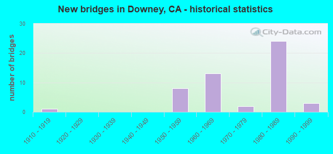
- New bridges - historical statistics
- 11910-1919
- 81950-1959
- 131960-1969
- 21970-1979
- 241980-1989
- 31990-1999

- Reconstructed bridges - Historical Statistics
- 21960-1969
- 31970-1979
- 11980-1989
- 11990-1999


- Bridge Condition - Deck
- 69.6%Good
- 26.1%Fair
- 4.3%Poor

- Bridge Condition - Superstructure
- 69.6%Good
- 21.7%Fair
- 8.7%Poor

- Bridge Condition - Channel
- 45.5%Excellent
- 54.5%Very good

- Bridge Condition - Culverts
- 33.3%Good
- 66.7%Satisfactory
Find on map >> Show street view
Structure Number: 53 0639, Location: 07-LA-005-9.47-DNY (Lat: 33.971489, Lng: -118.122681), Route carried "on" structure: Interstate 5, Year Built: 1953, Year Reconstructed: 1982, Status: Open, Structure Length: 19.35m (63.48ft), Average Daily Traffic: 233,000 (year 2011), Average Future Daily Traffic: 259,854 (year 2040), Design Load: HS 20, Features Intersected: RIO HONDO
Minimum Vertical Clearance: 30+ m (98+ ft), Kilometerpoint: 9.470, Lanes on structure: 8, Base Highway Network: Yes (, Subroute: 1), Owner: State Highway Agency, Approaching Roadway Width: 36.6m (120.1ft), Skew: 22 degrees, Material/Design: Concrete, Design/Construction: Stringer/Multi-beam, Number Of Spans In Main Unit: 8, Length of Maximum Span: 25.3m (83.0ft), Curb or Sidewalk Widths: Left: 0.9m (3.0ft), Right: 0.0m, Curb-To-Curb Width: 36.6m (120.1ft), Out-to-Out Width: 40.1m (131.6ft)
Condition: Deck: Fair, Superstructure: Good, Substructure: Good, Channel: Excellent, Operating Rating: 53.1 metric tons, Method Used To Determine Operating Rating: Load and Resistance Factor Rating (LRFR) rating reported by rating factor(RF) method using HL-93 loadings, Inventory Rating: 41.1 metric tons, Method Used To Determine Inventory Rating: Load and Resistance Factor Rating (LRFR) rating reported by rating factor(RF) method using HL-93 loadings, Structural Evaluation: Better than present minimum criteria, Deck Geometry: Better than present minimum criteria, Waterway Adequacy: Superior to present desirable criteria, Approach Roadway Alignment: Equal to present desirable criteria, Designated Inspection Frequency: Every 24 months, Inspection Date: November 2020, Deck Structure Type: Concrete Cast-file-Place
Find on map >> Show street view
Structure Number: 53 0765, Location: 07-LA-005-8.95-DNY (Lat: 33.964258, Lng: -118.119806), Route carried "on" structure: Interstate 5, Year Built: 1953, Year Reconstructed: 1982, Status: Open, Structure Length: 4.89m (16.04ft), Average Daily Traffic: 233,000 (year 2011), Average Future Daily Traffic: 259,854 (year 2040), Design Load: HS 20, Features Intersected: PARAMOUNT BLVD
Minimum Vertical Clearance: 30+ m (98+ ft), Kilometerpoint: 8.950, Lanes on structure: 9, Lanes under structure: 5, Base Highway Network: Yes (, Subroute: 1), Owner: State Highway Agency, Approaching Roadway Width: 38.4m (126.0ft), Skew: 20 degrees, Material/Design: Concrete continuous, Design/Construction: Box Beam or Girders - Multiple, Number Of Spans In Main Unit: 3, Length of Maximum Span: 24.4m (80.1ft), Curb-To-Curb Width: 39.6m (129.9ft), Out-to-Out Width: 43.1m (141.4ft)
Condition: Deck: Fair, Superstructure: Good, Substructure: Good, Operating Rating: 85.2 metric tons, Method Used To Determine Operating Rating: Load Factor (LF), Inventory Rating: 49.9 metric tons, Method Used To Determine Inventory Rating: Load Factor (LF), Structural Evaluation: Better than present minimum criteria, Deck Geometry: Better than present minimum criteria, Underclear: Meets minimum limits, Approach Roadway Alignment: Equal to present desirable criteria, Length Of Structure Improvement: 4.91m (16.11ft), Designated Inspection Frequency: Every 24 months, Inspection Date: November 2020, Deck Structure Type: Concrete Cast-file-Place
Find on map >> Show street view
Structure Number: 53 1048, Location: 07-LA-005-7.87-DNY (Lat: 33.953872, Lng: -118.105919), Route carried "on" structure: Interstate 5, Year Built: 1953, Year Reconstructed: 1972, Status: Open, Structure Length: 0.70m (2.30ft), Average Daily Traffic: 230,000 (year 2010), Truck Traffic: 7%, Average Future Daily Traffic: 287,022 (year 2037), Design Load: HS 20, Features Intersected: LEMORAN AVE STORM DRAIN
Minimum Vertical Clearance: 30+ m (98+ ft), Kilometerpoint: 7.870, Lanes on structure: 8, Base Highway Network: Yes (, Subroute: 1), Owner: State Highway Agency, Approaching Roadway Width: 32.3m (106.0ft), Skew: 30 degrees, Material/Design: Concrete continuous, Design/Construction: Culvert, Number Of Spans In Main Unit: 2, Length of Maximum Span: 3.4m (11.2ft), Curb-To-Curb Width: 39.1m (128.3ft), Out-to-Out Width: 41.5m (136.2ft)
Condition: Channel: Very good, Culverts: Good, Operating Rating: 54.1 metric tons, Method Used To Determine Operating Rating: Field evaluation and documented engineering judgment, Inventory Rating: 32.4 metric tons, Method Used To Determine Inventory Rating: Field evaluation and documented engineering judgment, Structural Evaluation: Better than present minimum criteria, Deck Geometry: Superior to present desirable criteria, Waterway Adequacy: Equal to present desirable criteria, Approach Roadway Alignment: Superior to present desirable criteria, Designated Inspection Frequency: Every 24 months, Inspection Date: November 2020
Find on map >> Show street view
Structure Number: 53 165, Location: 07-LA-605-R7.34-NRW (Lat: 33.909528, Lng: -118.104772), Route carried "on" structure: Interstate 605, Year Built: 1966, Year Reconstructed: 1993, Status: Open, Structure Length: 6.95m (22.80ft), Average Daily Traffic: 297,000 (year 2012), Truck Traffic: 6%, Average Future Daily Traffic: 305,454 (year 2039), Design Load: HS 20+Mod, Features Intersected: FOSTER ROAD
Minimum Vertical Clearance: 30+ m (98+ ft), Kilometerpoint: 7.340, Lanes on structure: 12, Lanes under structure: 4, Base Highway Network: Yes (Inventory Route: 6, Subroute: 3), Owner: State Highway Agency, Approaching Roadway Width: 48.2m (158.1ft), Skew: 30 degrees, Material/Design: Concrete continuous, Design/Construction: Box Beam or Girders - Multiple, Number Of Spans In Main Unit: 5, Length of Maximum Span: 23.2m (76.1ft), Curb-To-Curb Width: 48.2m (158.1ft), Out-to-Out Width: 50.0m (164.0ft)
Condition: Deck: Good, Superstructure: Good, Substructure: Good, Operating Rating: 66.7 metric tons, Method Used To Determine Operating Rating: Assigned rating based on Load Factor Design (LFD) reported in metric tons, Inventory Rating: 40.2 metric tons, Method Used To Determine Inventory Rating: Assigned rating based on Load Factor Design (LFD) reported in metric tons, Structural Evaluation: Better than present minimum criteria, Deck Geometry: Meets minimum limits, Underclear: Equal to present minimum criteria, Approach Roadway Alignment: Superior to present desirable criteria, Designated Inspection Frequency: Every 24 months, Inspection Date: August 2021, Deck Structure Type: Concrete Cast-file-Place
Find on map >> Show street view
Structure Number: 53 1655G, Location: 07-LA-605-R9.22-DNY (Lat: 33.935717, Lng: -118.098814), Route carried "on" structure: Ramp Interstate 605, Year Built: 1965, Status: Open, Structure Length: 2.81m (9.22ft), Average Daily Traffic: 22,400 (year 2012), Truck Traffic: 2%, Average Future Daily Traffic: 23,969 (year 2039), Design Load: HS 20, Features Intersected: STUDEBAKER RD-N605 ON-RP
Minimum Vertical Clearance: 30+ m (98+ ft), Kilometerpoint: 9.220, Lanes on structure: 2, Lanes under structure: 1, Base Highway Network: Yes (Inventory Route: 6, Subroute: 1), Owner: State Highway Agency, Approaching Roadway Width: 8.5m (27.9ft), Skew: 1 degrees, Material/Design: Concrete continuous, Design/Construction: Slab, Number Of Spans In Main Unit: 3, Length of Maximum Span: 11.0m (36.1ft), Curb or Sidewalk Widths: Left: 0.6m (2.0ft), Right: 0.6m (2.0ft), Curb-To-Curb Width: 8.5m (27.9ft), Out-to-Out Width: 10.4m (34.1ft)
Condition: Deck: Good, Superstructure: Good, Substructure: Good, Operating Rating: 62.2 metric tons, Method Used To Determine Operating Rating: Load Factor (LF), Inventory Rating: 37.3 metric tons, Method Used To Determine Inventory Rating: Load Factor (LF), Structural Evaluation: Better than present minimum criteria, Deck Geometry: High priority of corrective action, Underclear: Somewhat better than minimum adequacy, Approach Roadway Alignment: Equal to present desirable criteria, Designated Inspection Frequency: Every 24 months, Inspection Date: September 2021, Deck Structure Type: Concrete Cast-file-Place
Find on map >> Show street view
Structure Number: 53 1656, Location: 07-LA-605-R9.35-DNY (Lat: 33.937631, Lng: -118.098244), Route carried "on" structure: Interstate 605, Year Built: 1965, Year Reconstructed: 1997, Status: Open, Structure Length: 5.25m (17.22ft), Average Daily Traffic: 298,000 (year 2012), Truck Traffic: 6%, Average Future Daily Traffic: 276,624 (year 2039), Design Load: HS 20, Features Intersected: FLORENCE AVE
Minimum Vertical Clearance: 5.20m (17.06ft), Kilometerpoint: 9.350, Lanes on structure: 11, Lanes under structure: 7, Base Highway Network: Yes (Inventory Route: 6, Subroute: 3), Owner: State Highway Agency, Approaching Roadway Width: 45.0m (147.6ft), Skew: 30 degrees, Material/Design: Prestressed concrete, Design/Construction: Stringer/Multi-beam, Number Of Spans In Main Unit: 2, Number Of Approach Spans: 2, Length of Maximum Span: 19.5m (64.0ft), Curb-To-Curb Width: 45.0m (147.6ft), Out-to-Out Width: 46.8m (153.5ft)
Condition: Deck: Good, Superstructure: Good, Substructure: Good, Operating Rating: 28.8 metric tons, Method Used To Determine Operating Rating: Load and Resistance Factor Rating (LRFR) rating reported by rating factor(RF) method using HL-93 loadings, Inventory Rating: 22.0 metric tons, Method Used To Determine Inventory Rating: Load and Resistance Factor Rating (LRFR) rating reported by rating factor(RF) method using HL-93 loadings, Structural Evaluation: Somewhat better than minimum adequacy, Deck Geometry: Somewhat better than minimum adequacy, Underclear: Equal to present minimum criteria, Approach Roadway Alignment: Equal to present desirable criteria, Designated Inspection Frequency: Every 24 months, Inspection Date: September 2021, Deck Structure Type: Concrete Cast-file-Place
Find on map >> Show street view
Structure Number: 53 1656G, Location: 07-LA-605-R9.35-DNY (Lat: 33.937461, Lng: -118.097739), Route carried "on" structure: Ramp Interstate 605, Year Built: 1965, Status: Open, Structure Length: 5.25m (17.22ft), Average Daily Traffic: 23,000 (year 2012), Truck Traffic: 2%, Average Future Daily Traffic: 26,099 (year 2039), Design Load: HS 20, Features Intersected: FLORENCE AVE
Minimum Vertical Clearance: 30+ m (98+ ft), Kilometerpoint: 9.350, Lanes on structure: 3, Lanes under structure: 6, Base Highway Network: Yes (Inventory Route: 6, Subroute: 1), Owner: State Highway Agency, Approaching Roadway Width: 12.2m (40.0ft), Material/Design: Prestressed concrete, Design/Construction: Stringer/Multi-beam, Number Of Spans In Main Unit: 2, Number Of Approach Spans: 2, Length of Maximum Span: 19.5m (64.0ft), Curb or Sidewalk Widths: Left: 0.6m (2.0ft), Right: 0.6m (2.0ft), Curb-To-Curb Width: 12.2m (40.0ft), Out-to-Out Width: 14.0m (45.9ft)
Condition: Deck: Good, Superstructure: Good, Substructure: Good, Operating Rating: 66.1 metric tons, Method Used To Determine Operating Rating: Load Factor (LF), Inventory Rating: 32.4 metric tons, Method Used To Determine Inventory Rating: Load Factor (LF), Structural Evaluation: Better than present minimum criteria, Deck Geometry: High priority of corrective action, Underclear: Somewhat better than minimum adequacy, Approach Roadway Alignment: Superior to present desirable criteria, Designated Inspection Frequency: Every 24 months, Inspection Date: September 2021, Deck Structure Type: Concrete Cast-file-Place
Find on map >> Show street view
Structure Number: 53 1659K, Location: 07-LA-605-R9.54-DNY (Lat: 33.941289, Lng: -118.098389), Route carried "on" structure: Ramp Interstate 605, Year Built: 1965, Status: Open, Structure Length: 8.41m (27.59ft), Average Daily Traffic: 3,650 (year 2012), Truck Traffic: 2%, Average Future Daily Traffic: 4,021 (year 2039), Design Load: HS 20, Features Intersected: S5-N&S605 CONN
Minimum Vertical Clearance: 30+ m (98+ ft), Kilometerpoint: 9.540, Lanes on structure: 1, Lanes under structure: 2, Base Highway Network: Yes (Inventory Route: 6, Subroute: 1), Owner: State Highway Agency, Approaching Roadway Width: 6.7m (22.0ft), Material/Design: Concrete continuous, Design/Construction: Box Beam or Girders - Multiple, Number Of Spans In Main Unit: 3, Length of Maximum Span: 33.7m (110.6ft), Curb or Sidewalk Widths: Left: 0.0m, Right: 0.6m (2.0ft), Curb-To-Curb Width: 6.7m (22.0ft), Out-to-Out Width: 8.0m (26.2ft)
Condition: Deck: Good, Superstructure: Good, Substructure: Good, Operating Rating: 34.3 metric tons, Method Used To Determine Operating Rating: Load and Resistance Factor Rating (LRFR) rating reported by rating factor(RF) method using HL-93 loadings, Inventory Rating: 26.6 metric tons, Method Used To Determine Inventory Rating: Load and Resistance Factor Rating (LRFR) rating reported by rating factor(RF) method using HL-93 loadings, Structural Evaluation: Equal to present minimum criteria, Deck Geometry: Equal to present minimum criteria, Underclear: High priority of corrective action, Approach Roadway Alignment: Meets minimum limits, Designated Inspection Frequency: Every 24 months, Inspection Date: September 2021, Deck Structure Type: Concrete Cast-file-Place
Find on map >> Show street view
Structure Number: 53 1800L, Location: 07-LA-005-R82.08 (Lat: 34.766403, Lng: -118.799797), Route carried "on" structure: Interstate 5, Year Built: 1967, Status: Open, Structure Length: 6.58m (21.59ft), Average Daily Traffic: 35,890 (year 2011), Truck Traffic: 26%, Average Future Daily Traffic: 62,346 (year 2039), Design Load: HS 20, Features Intersected: S5-E138 CONNECTOR RAMP
Minimum Vertical Clearance: 30+ m (98+ ft), Kilometerpoint: 82.080, Lanes on structure: 4, Lanes under structure: 2, Base Highway Network: Yes (, Subroute: 1), Owner: State Highway Agency, Approaching Roadway Width: 20.1m (65.9ft), Skew: 6 degrees, Material/Design: Concrete continuous, Design/Construction: Box Beam or Girders - Multiple, Number Of Spans In Main Unit: 3, Length of Maximum Span: 32.5m (106.6ft), Curb-To-Curb Width: 20.1m (65.9ft), Out-to-Out Width: 20.7m (67.9ft)
Condition: Deck: Good, Superstructure: Good, Substructure: Good, Operating Rating: 60.9 metric tons, Method Used To Determine Operating Rating: Load and Resistance Factor Rating (LRFR) rating reported by rating factor(RF) method using HL-93 loadings, Inventory Rating: 47.0 metric tons, Method Used To Determine Inventory Rating: Load and Resistance Factor Rating (LRFR) rating reported by rating factor(RF) method using HL-93 loadings, Structural Evaluation: Better than present minimum criteria, Deck Geometry: Equal to present minimum criteria, Underclear: Meets minimum limits, Approach Roadway Alignment: Equal to present desirable criteria, Designated Inspection Frequency: Every 24 months, Inspection Date: June 2021, Deck Structure Type: Concrete Cast-file-Place, Wearing Surface/Protective System: Wearing Surface: Integral Concrete
Find on map >> Show street view
Structure Number: 53 2562, Location: 07-LA-210-R10.53-LA (Lat: 34.266289, Lng: -118.336433), Route carried "on" structure: Interstate 210, Year Built: 1980, Status: Open, Structure Length: 10.18m (33.40ft), Average Daily Traffic: 113,000 (year 2017), Truck Traffic: 6%, Average Future Daily Traffic: 120,623 (year 2041), Design Load: HS 20, Features Intersected: S BR BIG TUJUNGA WASH
Minimum Vertical Clearance: 30+ m (98+ ft), Kilometerpoint: 10.530, Lanes on structure: 8, Base Highway Network: Yes (Inventory Route: 2, Subroute: 1), Owner: State Highway Agency, Approaching Roadway Width: 43.9m (144.0ft), Skew: 33 degrees, Material/Design: Prestressed concrete continuous, Design/Construction: Box Beam or Girders - Multiple, Number Of Spans In Main Unit: 2, Length of Maximum Span: 49.5m (162.4ft), Curb-To-Curb Width: 43.4m (142.4ft), Out-to-Out Width: 45.1m (148.0ft)
Condition: Deck: Good, Superstructure: Good, Substructure: Good, Channel: Very good, Operating Rating: 99.8 metric tons, Method Used To Determine Operating Rating: Load Factor (LF), Inventory Rating: 32.4 metric tons, Method Used To Determine Inventory Rating: Load Factor (LF), Structural Evaluation: Better than present minimum criteria, Deck Geometry: Superior to present desirable criteria, Waterway Adequacy: Equal to present desirable criteria, Approach Roadway Alignment: Equal to present desirable criteria, Designated Inspection Frequency: Every 24 months, Inspection Date: August 2020, Deck Structure Type: Concrete Cast-file-Place
Find on map >> Show street view
Structure Number: 53 2564, Location: 07-LA-105-R15.54-DNY (Lat: 33.912617, Lng: -118.144858), Route carried "on" structure: City street , Year Built: 1987, Status: Open, Structure Length: 11.41m (37.43ft), Average Daily Traffic: 1,000 (year 2006), Truck Traffic: 1%, Average Future Daily Traffic: 1,355 (year 2042), Design Load: HS 20+Mod, Features Intersected: ROUTE 105, LRT, RAMPS, Facility Carried by Structure: BARLIN AVE
Minimum Vertical Clearance: 30+ m (98+ ft), Kilometerpoint: 0.000, Lanes on structure: 2, Lanes under structure: 10, Owner: State Highway Agency, Approaching Roadway Width: 11.0m (36.1ft), Skew: 3 degrees, Material/Design: Prestressed concrete continuous, Design/Construction: Box Beam or Girders - Multiple, Number Of Spans In Main Unit: 2, Length of Maximum Span: 58.8m (192.9ft), Curb or Sidewalk Widths: Left: 1.5m (4.9ft), Right: 1.5m (4.9ft), Curb-To-Curb Width: 11.0m (36.1ft), Out-to-Out Width: 14.6m (47.9ft)
Condition: Deck: Good, Superstructure: Fair, Substructure: Good, Operating Rating: 58.0 metric tons, Method Used To Determine Operating Rating: Load and Resistance Factor Rating (LRFR) rating reported by rating factor(RF) method using HL-93 loadings, Inventory Rating: 27.5 metric tons, Method Used To Determine Inventory Rating: Load and Resistance Factor Rating (LRFR) rating reported by rating factor(RF) method using HL-93 loadings, Structural Evaluation: Somewhat better than minimum adequacy, Deck Geometry: Better than present minimum criteria, Underclear: High priority of corrective action, Approach Roadway Alignment: Equal to present desirable criteria, Designated Inspection Frequency: Every 24 months, Inspection Date: July 2020, Deck Structure Type: Concrete Cast-file-Place
Find on map >> Show street view
Structure Number: 53 2565G, Location: 07-LA-105-R15.64-DNY (Lat: 33.912692, Lng: -118.143092), Route carried "on" structure: Ramp Interstate 105, Year Built: 1991, Status: Open, Structure Length: 17.22m (56.50ft), Average Daily Traffic: 5,100 (year 2006), Truck Traffic: 2%, Average Future Daily Traffic: 5,719 (year 2042), Design Load: HS 20+Mod, Features Intersected: ROUTE 105, LRT
Minimum Vertical Clearance: 30+ m (98+ ft), Kilometerpoint: 15.640, Lanes on structure: 1, Lanes under structure: 8, Owner: State Highway Agency, Approaching Roadway Width: 7.3m (24.0ft), Skew: 9 degrees, Material/Design: Prestressed concrete continuous, Design/Construction: Box Beam or Girders - Multiple, Number Of Spans In Main Unit: 4, Length of Maximum Span: 58.8m (192.9ft), Curb-To-Curb Width: 7.3m (24.0ft), Out-to-Out Width: 8.4m (27.6ft)
Condition: Deck: Good, Superstructure: Good, Substructure: Good, Operating Rating: 54.1 metric tons, Method Used To Determine Operating Rating: Assigned rating based on Load Factor Design (LFD) reported in metric tons, Inventory Rating: 32.4 metric tons, Method Used To Determine Inventory Rating: Assigned rating based on Load Factor Design (LFD) reported in metric tons, Structural Evaluation: Better than present minimum criteria, Deck Geometry: Better than present minimum criteria, Underclear: Equal to present minimum criteria, Approach Roadway Alignment: Equal to present desirable criteria, Designated Inspection Frequency: Every 24 months, Inspection Date: July 2020, Deck Structure Type: Concrete Cast-file-Place
Find on map >> Show street view
Structure Number: 53 2566, Location: 07-LA-105-R15.76-DNY (Lat: 33.912728, Lng: -118.140683), Route carried "on" structure: City street , Year Built: 1989, Status: Open, Structure Length: 10.15m (33.30ft), Average Daily Traffic: 36,500 (year 2009), Truck Traffic: 5%, Average Future Daily Traffic: 49,465 (year 2042), Design Load: HS 20+Mod, Features Intersected: ROUTE 105, LRT, RAMP, Facility Carried by Structure: LAKEWOOD BLVD
Minimum Vertical Clearance: 30+ m (98+ ft), Kilometerpoint: 0.000, Lanes on structure: 6, Lanes under structure: 9, Base Highway Network: Yes, Owner: State Highway Agency, Approaching Roadway Width: 31.7m (104.0ft), Skew: 3 degrees, Material/Design: Prestressed concrete continuous, Design/Construction: Box Beam or Girders - Multiple, Number Of Spans In Main Unit: 1, Number Of Approach Spans: 1, Length of Maximum Span: 53.1m (174.2ft), Curb or Sidewalk Widths: Left: 4.3m (14.1ft), Right: 4.3m (14.1ft), Curb-To-Curb Width: 31.7m (104.0ft), Out-to-Out Width: 40.8m (133.9ft)
Condition: Deck: Good, Superstructure: Fair, Substructure: Good, Operating Rating: 54.1 metric tons, Method Used To Determine Operating Rating: Assigned rating based on Load Factor Design (LFD) reported in metric tons, Inventory Rating: 32.4 metric tons, Method Used To Determine Inventory Rating: Assigned rating based on Load Factor Design (LFD) reported in metric tons, Structural Evaluation: Somewhat better than minimum adequacy, Deck Geometry: Superior to present desirable criteria, Underclear: High priority of corrective action, Approach Roadway Alignment: Equal to present desirable criteria, Designated Inspection Frequency: Every 24 months, Inspection Date: July 2020, Deck Structure Type: Concrete Cast-file-Place
Find on map >> Show street view
Structure Number: 53 2567, Location: 07-LA-105-R15.94-DNY (Lat: 33.912622, Lng: -118.137567), Route carried "on" structure: City street , Year Built: 1988, Status: Open, Structure Length: 11.08m (36.35ft), Average Daily Traffic: 1,040 (year 2006), Truck Traffic: 1%, Average Future Daily Traffic: 1,175 (year 2042), Design Load: HS 20+Mod, Features Intersected: ROUTE 105, LRT, RAMPS, Facility Carried by Structure: HANWELL AVENUE
Minimum Vertical Clearance: 30+ m (98+ ft), Kilometerpoint: 0.000, Lanes on structure: 2, Lanes under structure: 11, Owner: State Highway Agency, Approaching Roadway Width: 9.1m (29.9ft), Material/Design: Prestressed concrete continuous, Design/Construction: Box Beam or Girders - Multiple, Number Of Spans In Main Unit: 2, Length of Maximum Span: 56.8m (186.4ft), Curb or Sidewalk Widths: Left: 1.5m (4.9ft), Right: 1.5m (4.9ft), Curb-To-Curb Width: 9.1m (29.9ft), Out-to-Out Width: 12.8m (42.0ft)
Condition: Deck: Good, Superstructure: Fair, Substructure: Good, Operating Rating: 54.1 metric tons, Method Used To Determine Operating Rating: Assigned rating based on Load Factor Design (LFD) reported in metric tons, Inventory Rating: 32.4 metric tons, Method Used To Determine Inventory Rating: Assigned rating based on Load Factor Design (LFD) reported in metric tons, Structural Evaluation: Somewhat better than minimum adequacy, Deck Geometry: Somewhat better than minimum adequacy, Underclear: High priority of corrective action, Approach Roadway Alignment: Superior to present desirable criteria, Designated Inspection Frequency: Every 24 months, Inspection Date: July 2020, Deck Structure Type: Concrete Cast-file-Place
Find on map >> Show street view
Structure Number: 53 2572, Location: 07-LA-105-R16.39-DNY (Lat: 33.912664, Lng: -118.129672), Route carried "on" structure: City street , Year Built: 1989, Status: Open, Structure Length: 9.48m (31.10ft), Average Daily Traffic: 3,700 (year 2006), Truck Traffic: 1%, Average Future Daily Traffic: 5,345 (year 2042), Design Load: HS 20+Mod, Features Intersected: ROUTE 105, LRT, RAMP, Facility Carried by Structure: ARDIS AVENUE
Minimum Vertical Clearance: 30+ m (98+ ft), Kilometerpoint: 0.000, Lanes on structure: 2, Lanes under structure: 11, Owner: State Highway Agency, Approaching Roadway Width: 12.2m (40.0ft), Skew: 9 degrees, Material/Design: Prestressed concrete continuous, Design/Construction: Box Beam or Girders - Multiple, Number Of Spans In Main Unit: 2, Length of Maximum Span: 49.6m (162.7ft), Curb or Sidewalk Widths: Left: 1.5m (4.9ft), Right: 1.5m (4.9ft), Curb-To-Curb Width: 12.2m (40.0ft), Out-to-Out Width: 15.8m (51.8ft)
Condition: Deck: Fair, Superstructure: Fair, Substructure: Good, Operating Rating: 54.1 metric tons, Method Used To Determine Operating Rating: Assigned rating based on Load Factor Design (LFD) reported in metric tons, Inventory Rating: 32.4 metric tons, Method Used To Determine Inventory Rating: Assigned rating based on Load Factor Design (LFD) reported in metric tons, Structural Evaluation: Somewhat better than minimum adequacy, Deck Geometry: Equal to present minimum criteria, Underclear: High priority of corrective action, Approach Roadway Alignment: Superior to present desirable criteria, Designated Inspection Frequency: Every 24 months, Inspection Date: July 2020, Deck Structure Type: Concrete Cast-file-Place
Find on map >> Show street view
Structure Number: 53 2573, Location: 07-LA-105-R16.64-DNY (Lat: 33.912847, Lng: -118.125261), Route carried "on" structure: City street L067, Year Built: 1989, Status: Open, Structure Length: 8.12m (26.64ft), Average Daily Traffic: 18,000 (year 2006), Truck Traffic: 2%, Average Future Daily Traffic: 33,134 (year 2042), Design Load: HS 20+Mod, Features Intersected: ROUTE 105, LRT, Facility Carried by Structure: BELLFLOWER BLVD
Minimum Vertical Clearance: 30+ m (98+ ft), Kilometerpoint: 0.000, Lanes on structure: 6, Lanes under structure: 10, Base Highway Network: Yes, Owner: State Highway Agency, Approaching Roadway Width: 21.3m (69.9ft), Material/Design: Prestressed concrete continuous, Design/Construction: Box Beam or Girders - Multiple, Number Of Spans In Main Unit: 2, Length of Maximum Span: 41.1m (134.8ft), Curb or Sidewalk Widths: Left: 2.4m (7.9ft), Right: 2.4m (7.9ft), Curb-To-Curb Width: 21.3m (69.9ft), Out-to-Out Width: 26.8m (87.9ft)
Condition: Deck: Good, Superstructure: Fair, Substructure: Good, Operating Rating: 54.1 metric tons, Method Used To Determine Operating Rating: Assigned rating based on Load Factor Design (LFD) reported in metric tons, Inventory Rating: 32.4 metric tons, Method Used To Determine Inventory Rating: Assigned rating based on Load Factor Design (LFD) reported in metric tons, Structural Evaluation: Somewhat better than minimum adequacy, Deck Geometry: High priority of replacement, Underclear: High priority of corrective action, Approach Roadway Alignment: Superior to present desirable criteria, Designated Inspection Frequency: Every 24 months, Inspection Date: July 2020, Deck Structure Type: Concrete Cast-file-Place
Find on map >> Show street view
Structure Number: 53 2574, Location: 07-LA-105-R16.89-DNY (Lat: 33.913006, Lng: -118.121003), Route carried "on" structure: City street , Year Built: 1987, Status: Open, Structure Length: 10.43m (34.22ft), Average Daily Traffic: 1,400 (year 2012), Truck Traffic: 1%, Average Future Daily Traffic: 2,095 (year 2038), Design Load: HS 20+Mod, Features Intersected: ROUTE 105, LRT, Facility Carried by Structure: DUNROBIN AVENUE
Minimum Vertical Clearance: 30+ m (98+ ft), Kilometerpoint: 0.000, Lanes on structure: 2, Lanes under structure: 11, Owner: State Highway Agency, Approaching Roadway Width: 11.0m (36.1ft), Material/Design: Prestressed concrete continuous, Design/Construction: Box Beam or Girders - Multiple, Number Of Spans In Main Unit: 2, Length of Maximum Span: 53.6m (175.9ft), Curb or Sidewalk Widths: Left: 1.5m (4.9ft), Right: 1.5m (4.9ft), Curb-To-Curb Width: 11.0m (36.1ft), Out-to-Out Width: 14.6m (47.9ft)
Condition: Deck: Good, Superstructure: Good, Substructure: Good, Operating Rating: 54.1 metric tons, Method Used To Determine Operating Rating: Assigned rating based on Load Factor Design (LFD) reported in metric tons, Inventory Rating: 32.4 metric tons, Method Used To Determine Inventory Rating: Assigned rating based on Load Factor Design (LFD) reported in metric tons, Structural Evaluation: Better than present minimum criteria, Deck Geometry: Equal to present minimum criteria, Underclear: High priority of corrective action, Approach Roadway Alignment: Superior to present desirable criteria, Designated Inspection Frequency: Every 24 months, Inspection Date: July 2020, Deck Structure Type: Concrete Cast-file-Place
Find on map >> Show street view
Structure Number: 53 2575, Location: 07-LA-105-R17.14-DNY (Lat: 33.913397, Lng: -118.116581), Route carried "on" structure: City street L068, Year Built: 1987, Status: Open, Structure Length: 8.93m (29.30ft), Average Daily Traffic: 14,500 (year 2011), Truck Traffic: 1%, Average Future Daily Traffic: 16,134 (year 2038), Design Load: HS 20+Mod, Features Intersected: ROUTE 105, LRT, Facility Carried by Structure: WOODRUFF AVENUE
Minimum Vertical Clearance: 30+ m (98+ ft), Kilometerpoint: 0.000, Lanes on structure: 4, Lanes under structure: 10, Base Highway Network: Yes, Owner: State Highway Agency, Approaching Roadway Width: 24.4m (80.1ft), Material/Design: Prestressed concrete continuous, Design/Construction: Box Beam or Girders - Multiple, Number Of Spans In Main Unit: 2, Length of Maximum Span: 44.8m (147.0ft), Curb or Sidewalk Widths: Left: 2.4m (7.9ft), Right: 2.4m (7.9ft), Curb-To-Curb Width: 24.4m (80.1ft), Out-to-Out Width: 29.9m (98.1ft)
Condition: Deck: Good, Superstructure: Poor, Substructure: Good, Operating Rating: 54.1 metric tons, Method Used To Determine Operating Rating: Assigned rating based on Load Factor Design (LFD) reported in metric tons, Inventory Rating: 32.4 metric tons, Method Used To Determine Inventory Rating: Assigned rating based on Load Factor Design (LFD) reported in metric tons, Structural Evaluation: Meets minimum limits, Deck Geometry: Superior to present desirable criteria, Underclear: High priority of corrective action, Approach Roadway Alignment: Superior to present desirable criteria, Length Of Structure Improvement: 8.93m (29.30ft), Designated Inspection Frequency: Every 24 months, Inspection Date: July 2020, Bridge Improvement Cost: $2,668,000, Roadway Improvement Cost: $533,000, Total Project Cost: $4,482,000 ( Estimate for 2021), Deck Structure Type: Concrete Cast-file-Place
Find on map >> Show street view
Structure Number: 53 2576, Location: 07-LA-105-R17.49-DNY (Lat: 33.913739, Lng: -118.111631), Route carried "on" structure: Interstate 105, Year Built: 1987, Status: Open, Structure Length: 11.60m (38.06ft), Average Daily Traffic: 201,000 (year 2010), Truck Traffic: 9%, Average Future Daily Traffic: 115,981 (year 2037), Design Load: HS 20+Mod, Features Intersected: SAN GABRIEL RIVER
Minimum Vertical Clearance: 30+ m (98+ ft), Kilometerpoint: 17.490, Lanes on structure: 4, Base Highway Network: Yes (Inventory Route: 1, Subroute: 1), Owner: State Highway Agency, Approaching Roadway Width: 19.5m (64.0ft), Skew: 31 degrees, Material/Design: Prestressed concrete continuous, Design/Construction: Box Beam or Girders - Multiple, Number Of Spans In Main Unit: 3, Length of Maximum Span: 45.7m (149.9ft), Curb-To-Curb Width: 19.5m (64.0ft), Out-to-Out Width: 32.2m (105.6ft)
Condition: Deck: Good, Superstructure: Good, Substructure: Good, Channel: Excellent, Operating Rating: 54.1 metric tons, Method Used To Determine Operating Rating: Assigned rating based on Load Factor Design (LFD) reported in metric tons, Inventory Rating: 32.4 metric tons, Method Used To Determine Inventory Rating: Assigned rating based on Load Factor Design (LFD) reported in metric tons, Structural Evaluation: Better than present minimum criteria, Deck Geometry: Somewhat better than minimum adequacy, Waterway Adequacy: Equal to present desirable criteria, Approach Roadway Alignment: Superior to present desirable criteria, Designated Inspection Frequency: Every 24 months, Inspection Date: July 2020, Deck Structure Type: Concrete Cast-file-Place
Find on map >> Show street view
Structure Number: 53 2698G, Location: 07-LA-105-R17.44-DNY (Lat: 33.913503, Lng: -118.111639), Route carried "on" structure: Interstate 105, Year Built: 1993, Status: Open, Structure Length: 11.84m (38.85ft), Average Daily Traffic: 201,000 (year 2010), Truck Traffic: 9%, Average Future Daily Traffic: 115,981 (year 2037), Design Load: HS 20+Mod, Features Intersected: SAN GABRIEL RIVER
Minimum Vertical Clearance: 30+ m (98+ ft), Kilometerpoint: 17.440, Lanes on structure: 4, Base Highway Network: Yes (Inventory Route: 1, Subroute: 1), Owner: State Highway Agency, Approaching Roadway Width: 19.1m (62.7ft), Skew: 1 degrees, Material/Design: Prestressed concrete continuous, Design/Construction: Box Beam or Girders - Multiple, Number Of Spans In Main Unit: 3, Length of Maximum Span: 46.1m (151.2ft), Curb-To-Curb Width: 19.1m (62.7ft), Out-to-Out Width: 20.1m (65.9ft)
Condition: Deck: Fair, Superstructure: Good, Substructure: Good, Channel: Very good, Operating Rating: 54.1 metric tons, Method Used To Determine Operating Rating: Assigned rating based on Load Factor Design (LFD) reported in metric tons, Inventory Rating: 32.4 metric tons, Method Used To Determine Inventory Rating: Assigned rating based on Load Factor Design (LFD) reported in metric tons, Structural Evaluation: Better than present minimum criteria, Deck Geometry: Somewhat better than minimum adequacy, Waterway Adequacy: Equal to present desirable criteria, Approach Roadway Alignment: Superior to present desirable criteria, Designated Inspection Frequency: Every 24 months, Inspection Date: July 2020, Deck Structure Type: Concrete Cast-file-Place
Find on map >> Show street view
Structure Number: 53C0085, Location: 1.0MI W/O PARAMOUNT BLVD (Lat: 33.960831, Lng: -118.144517), Route carried "on" structure: City street , Year Built: 1953, Year Reconstructed: 1975, Status: Open, Structure Length: 6.54m (21.46ft), Average Daily Traffic: 37,484 (year 2016), Truck Traffic: 3%, Average Future Daily Traffic: 46,786 (year 2041), Design Load: HS 20, Features Intersected: RIO HONDO, Facility Carried by Structure: FLORENCE AVE
Minimum Vertical Clearance: 30.47m (99.97ft), Kilometerpoint: 0.000, Lanes on structure: 6, Owner: City or Municipal Highway Agency, Approaching Roadway Width: 24.4m (80.1ft), Skew: 22 degrees, Material/Design: Concrete, Design/Construction: Tee Beam, Number Of Spans In Main Unit: 3, Length of Maximum Span: 25.9m (85.0ft), Curb or Sidewalk Widths: Left: 2.4m (7.9ft), Right: 2.4m (7.9ft), Curb-To-Curb Width: 22.4m (73.5ft), Out-to-Out Width: 29.0m (95.1ft)
Condition: Deck: Fair, Superstructure: Good, Substructure: Good, Channel: Excellent, Operating Rating: 45.4 metric tons, Method Used To Determine Operating Rating: Load Factor (LF), Inventory Rating: 27.2 metric tons, Method Used To Determine Inventory Rating: Load Factor (LF), Structural Evaluation: Equal to present minimum criteria, Deck Geometry: Meets minimum limits, Waterway Adequacy: Superior to present desirable criteria, Approach Roadway Alignment: Equal to present desirable criteria, Designated Inspection Frequency: Every 24 months, Inspection Date: March 2021, Deck Structure Type: Concrete Cast-file-Place
Find on map >> Show street view
Structure Number: 53C0106, Location: 0.5MI W/O I-605 FWY (Lat: 33.916975, Lng: -118.111847), Route carried "on" structure: City street , Year Built: 1952, Year Reconstructed: 1971, Status: Open, Structure Length: 9.30m (30.51ft), Average Daily Traffic: 36,741 (year 2016), Truck Traffic: 3%, Average Future Daily Traffic: 40,320 (year 2041), Design Load: HS 20, Features Intersected: SAN GABRIEL RIV / FR, Facility Carried by Structure: IMPERIAL HWY
Minimum Vertical Clearance: 4.32m (14.17ft), Kilometerpoint: 0.000, Lanes on structure: 6, Lanes under structure: 2, Owner: City or Municipal Highway Agency, Approaching Roadway Width: 21.3m (69.9ft), Skew: 20 degrees, Material/Design: Concrete continuous, Design/Construction: Tee Beam, Number Of Spans In Main Unit: 5, Length of Maximum Span: 20.4m (66.9ft), Curb or Sidewalk Widths: Left: 2.3m (7.5ft), Right: 2.3m (7.5ft), Curb-To-Curb Width: 21.2m (69.6ft), Out-to-Out Width: 27.7m (90.9ft)
Condition: Deck: Fair, Superstructure: Good, Substructure: Good, Channel: Excellent, Operating Rating: 56.7 metric tons, Method Used To Determine Operating Rating: Load Factor (LF), Inventory Rating: 33.7 metric tons, Method Used To Determine Inventory Rating: Load Factor (LF), Structural Evaluation: Better than present minimum criteria, Deck Geometry: High priority of replacement, Underclear: High priority of corrective action, Waterway Adequacy: Superior to present desirable criteria, Approach Roadway Alignment: Equal to present desirable criteria, Designated Inspection Frequency: Every 24 months, Inspection Date: March 2021, Deck Structure Type: Concrete Cast-file-Place
Find on map >> Show street view
Structure Number: 53C101, Location: 0.5 MI W/O I-5 (Lat: 34.067658, Lng: -118.225125), Route carried "on" structure: City street , Year Built: 1910, Status: Open, Structure Length: 8.85m (29.04ft), Average Daily Traffic: 30,000 (year 2003), Truck Traffic: 3%, Average Future Daily Traffic: 41,216 (year 2035), Design Load: H 20, Features Intersected: LOS ANGELES RIVER, Facility Carried by Structure: N MAIN ST
Minimum Vertical Clearance: 30+ m (98+ ft), Kilometerpoint: 0.000, Lanes on structure: 4, Base Highway Network: Yes, Owner: City or Municipal Highway Agency, Approaching Roadway Width: 17.1m (56.1ft), Skew: 1 degrees, Material/Design: Concrete, Design/Construction: Arch - Deck, Number Of Spans In Main Unit: 3, Length of Maximum Span: 29.5m (96.8ft), Curb or Sidewalk Widths: Left: 1.8m (5.9ft), Right: 1.8m (5.9ft), Curb-To-Curb Width: 17.1m (56.1ft), Out-to-Out Width: 21.2m (69.6ft)
Condition: Deck: Good, Superstructure: Good, Substructure: Good, Channel: Very good, Operating Rating: 66.1 metric tons, Method Used To Determine Operating Rating: Load Factor (LF), Inventory Rating: 39.9 metric tons, Method Used To Determine Inventory Rating: Load Factor (LF), Structural Evaluation: Better than present minimum criteria, Deck Geometry: Somewhat better than minimum adequacy, Waterway Adequacy: Superior to present desirable criteria, Approach Roadway Alignment: Equal to present minimum criteria, Designated Inspection Frequency: Every 48 months, Inspection Date: October 2018, Deck Structure Type: Concrete Cast-file-Place, Wearing Surface/Protective System: Wearing Surface: Integral Concrete
Find on map >> Show street view
Structure Number: 53C1018, Location: 0.8MI N/O FLORENCE AVE (Lat: 33.965203, Lng: -118.136153), Route carried "on" structure: City street , Year Built: 1954, Status: Posted for load, Structure Length: 6.79m (22.28ft), Average Daily Traffic: 11,589 (year 2016), Truck Traffic: 1%, Average Future Daily Traffic: 9,831 (year 2042), Design Load: HS 20, Features Intersected: RIO HONDO, Facility Carried by Structure: SUVA ST
Minimum Vertical Clearance: 30.47m (99.97ft), Kilometerpoint: 0.000, Lanes on structure: 2, Owner: City or Municipal Highway Agency, Approaching Roadway Width: 7.9m (25.9ft), Skew: 2 degrees, Material/Design: Steel, Design/Construction: Stringer/Multi-beam, Number Of Spans In Main Unit: 3, Length of Maximum Span: 26.8m (87.9ft), Curb or Sidewalk Widths: Left: 1.6m (5.2ft), Right: 1.6m (5.2ft), Curb-To-Curb Width: 7.9m (25.9ft), Out-to-Out Width: 11.6m (38.1ft)
Condition: Deck: Poor, Superstructure: Poor, Substructure: Good, Channel: Excellent, Operating Rating: 20.4 metric tons, Method Used To Determine Operating Rating: Load Factor (LF), Inventory Rating: 12.3 metric tons, Method Used To Determine Inventory Rating: Load Factor (LF), Structural Evaluation: High priority of replacement, Deck Geometry: High priority of corrective action, Waterway Adequacy: Superior to present desirable criteria, Approach Roadway Alignment: Better than present minimum criteria, Bridge Posting: Required (Relationship of Operating Rating to Maximum Legal Load: 10.0 - 19.9% below), Designated Inspection Frequency: Every 12 months, Inspection Date: September 2021, Bridge Improvement Cost: $1,814,000, Roadway Improvement Cost: $362,000, Total Project Cost: $3,048,000 ( Estimate for 2017), Deck Structure Type: Concrete Cast-file-Place
Find on map >> Show street view
Structure Number: 53C1645, Location: 0.1MI W/O PASSONS BLVD (Lat: 33.956033, Lng: -118.104886), Route carried "on" structure: City street , Year Built: 1967, Status: Open, Structure Length: 0.70m (2.30ft), Average Daily Traffic: 2,499 (year 2012), Average Future Daily Traffic: 2,749 (year 2041), Features Intersected: LEMORAN AVE STORM DRN, Facility Carried by Structure: CEDARTREE RD
Minimum Vertical Clearance: 30.47m (99.97ft), Kilometerpoint: 0.000, Lanes on structure: 2, Owner: City or Municipal Highway Agency, Approaching Roadway Width: 11.0m (36.1ft), Material/Design: Concrete, Design/Construction: Culvert, Number Of Spans In Main Unit: 3, Length of Maximum Span: 2.1m (6.9ft), Curb or Sidewalk Widths: Left: 3.5m (11.5ft), Right: 3.4m (11.2ft), Curb-To-Curb Width: 10.9m (35.8ft), Out-to-Out Width: 18.2m (59.7ft)
Condition: Channel: Very good, Culverts: Satisfactory, Operating Rating: 40.5 metric tons, Method Used To Determine Operating Rating: Field evaluation and documented engineering judgment, Inventory Rating: 24.3 metric tons, Method Used To Determine Inventory Rating: Field evaluation and documented engineering judgment, Structural Evaluation: Equal to present minimum criteria, Deck Geometry: Somewhat better than minimum adequacy, Waterway Adequacy: Better than present minimum criteria, Approach Roadway Alignment: Equal to present desirable criteria, Designated Inspection Frequency: Every 24 months, Inspection Date: March 2021
Find on map >> Show street view
Structure Number: 53C1646, Location: 0.1MI W/O PASSONS BLVD (Lat: 33.953978, Lng: -118.105931), Route carried "on" structure: City street , Year Built: 1967, Status: Open, Structure Length: 0.70m (2.30ft), Average Daily Traffic: 408 (year 2012), Average Future Daily Traffic: 408 (year 2041), Features Intersected: LEMORAN AVE STORM DRN, Facility Carried by Structure: BROOKPARK RD
Minimum Vertical Clearance: 30.47m (99.97ft), Kilometerpoint: 0.000, Lanes on structure: 2, Owner: City or Municipal Highway Agency, Approaching Roadway Width: 8.5m (27.9ft), Skew: 1 degrees, Material/Design: Concrete, Design/Construction: Culvert, Number Of Spans In Main Unit: 3, Length of Maximum Span: 2.1m (6.9ft), Curb or Sidewalk Widths: Left: 1.3m (4.3ft), Right: 0.5m (1.6ft), Curb-To-Curb Width: 8.4m (27.6ft), Out-to-Out Width: 13.0m (42.7ft)
Condition: Channel: Very good, Culverts: Satisfactory, Operating Rating: 40.5 metric tons, Method Used To Determine Operating Rating: Field evaluation and documented engineering judgment, Inventory Rating: 24.3 metric tons, Method Used To Determine Inventory Rating: Field evaluation and documented engineering judgment, Structural Evaluation: Equal to present minimum criteria, Deck Geometry: Somewhat better than minimum adequacy, Waterway Adequacy: Equal to present desirable criteria, Approach Roadway Alignment: Equal to present desirable criteria, Designated Inspection Frequency: Every 24 months, Inspection Date: March 2021
Find on map >> Show street view
Structure Number: 53 064, Location: 07-LA-005-8.29-DNY (Lat: 33.957900, Lng: -118.111419), Route carried "under" structure: City street , Year Built: 1953, Structure Length: 0. m, Average Daily Traffic: 26,500 (year 2010), Truck Traffic: 4%, Features Intersected: LAKEWOOD BLVD, Facility Carried by Structure: INTERSTATE 5
Minimum Vertical Clearance: 4.47m (14.67ft), Kilometerpoint: 0.000, Lanes on structure: 10, Lanes under structure: 8, Material/Design: Concrete continuous, Design/Construction: Box Beam or Girders - Multiple, Length of Maximum Span: 20.4m (66.9ft)
Find on map >> Show street view
Structure Number: 53 0765, Location: 07-LA-005-8.95-DNY (Lat: 33.964258, Lng: -118.119806), Route carried "under" structure: City street , Year Built: 1953, Structure Length: 0. m, Average Daily Traffic: 22,000 (year 2011), Truck Traffic: 3%, Features Intersected: PARAMOUNT BLVD, Facility Carried by Structure: INTERSTATE 5
Minimum Vertical Clearance: 4.62m (15.16ft), Kilometerpoint: 0.000, Lanes on structure: 9, Lanes under structure: 5, Material/Design: Concrete continuous, Design/Construction: Box Beam or Girders - Multiple, Length of Maximum Span: 24.4m (80.1ft)
Find on map >> Show street view
Structure Number: 53 1655G, Location: 07-LA-605-R9.22-DNY (Lat: 33.935717, Lng: -118.098814), Route carried "under" structure: Ramp Interstate 605, Year Built: 1965, Structure Length: 0. m, Average Daily Traffic: 2,500 (year 2012), Truck Traffic: 1%, Features Intersected: STUDEBAKER RD-N605 ON-RP
Minimum Vertical Clearance: 4.85m (15.91ft), Kilometerpoint: 9.220, Lanes on structure: 2, Lanes under structure: 1, Material/Design: Concrete continuous, Design/Construction: Slab, Length of Maximum Span: 11.0m (36.1ft)
Find on map >> Show street view
Structure Number: 53 1656, Location: 07-LA-605-R9.35-DNY (Lat: 33.937631, Lng: -118.098244), Route carried "under" structure: City street L120, Year Built: 1965, Structure Length: 0. m, Average Daily Traffic: 33,000 (year 2012), Truck Traffic: 2%, Features Intersected: FLORENCE AVE, Facility Carried by Structure: INTERSTATE 605
Minimum Vertical Clearance: 4.52m (14.83ft), Kilometerpoint: 0.000, Lanes on structure: 11, Lanes under structure: 7, Material/Design: Prestressed concrete, Design/Construction: Stringer/Multi-beam, Length of Maximum Span: 19.5m (64.0ft)
Find on map >> Show street view
Structure Number: 53 1656G, Location: 07-LA-605-R9.35-DNY (Lat: 33.937461, Lng: -118.097739), Route carried "under" structure: City street L120, Year Built: 1965, Structure Length: 0. m, Average Daily Traffic: 33,000 (year 2012), Truck Traffic: 2%, Features Intersected: FLORENCE AVE, Facility Carried by Structure: N605-S5 CONNECTOR
Minimum Vertical Clearance: 4.52m (14.83ft), Kilometerpoint: 0.000, Lanes on structure: 3, Lanes under structure: 6, Material/Design: Prestressed concrete, Design/Construction: Stringer/Multi-beam, Length of Maximum Span: 19.5m (64.0ft)
Find on map >> Show street view
Structure Number: 53 1659K, Location: 07-LA-605-R9.54-DNY (Lat: 33.941289, Lng: -118.098389), Route carried "under" structure: Interstate 5, Year Built: 1965, Structure Length: 0. m, Average Daily Traffic: 230,000 (year 2012), Truck Traffic: 7%, Features Intersected: S5-N&S605 CONN
Minimum Vertical Clearance: 5.74m (18.83ft), Kilometerpoint: 6.930, Lanes on structure: 1, Lanes under structure: 1, Material/Design: Concrete continuous, Design/Construction: Box Beam or Girders - Multiple, Length of Maximum Span: 33.7m (110.6ft)
Find on map >> Show street view
Structure Number: 53 1659K, Location: 07-LA-605-R9.54-DNY (Lat: 33.941289, Lng: -118.098389), Route carried "under" structure: Ramp Interstate 5, Year Built: 1965, Structure Length: 0. m, Average Daily Traffic: 5,500 (year 2012), Truck Traffic: 2%, Features Intersected: S5-N&S605 CONN
Minimum Vertical Clearance: 5.56m (18.24ft), Kilometerpoint: 6.930, Lanes on structure: 1, Lanes under structure: 1, Material/Design: Concrete continuous, Design/Construction: Box Beam or Girders - Multiple, Length of Maximum Span: 33.7m (110.6ft)
Find on map >> Show street view
Structure Number: 53 1804, Location: 07-LA-005-9.15-DNY (Lat: 33.967125, Lng: -118.121822), Route carried "under" structure: Interstate 5, Year Built: 1982, Structure Length: 0. m, Average Daily Traffic: 233,000 (year 2009), Features Intersected: INTERSTATE 5, Facility Carried by Structure: PEDESTRIAN WALKWAY
Minimum Vertical Clearance: 5.84m (19.16ft), Kilometerpoint: 9.150, Lanes under structure: 8, Material/Design: Concrete continuous, Design/Construction: Box Beam or Girders - Multiple, Length of Maximum Span: 25.9m (85.0ft)
Find on map >> Show street view
Structure Number: 53 243, Location: 07-LA-105-R15.36-DNY (Lat: 33.913225, Lng: -118.148439), Route carried "under" structure: Interstate 105, Year Built: 1989, Structure Length: 0. m, Average Daily Traffic: 201,000 (year 2009), Truck Traffic: 9%, Features Intersected: ROUTE 105, LRT, Facility Carried by Structure: GARDENDALE, LAUREL
Minimum Vertical Clearance: 5.18m (16.99ft), Kilometerpoint: 15.360, Lanes on structure: 3, Lanes under structure: 8, Material/Design: Prestressed concrete continuous, Design/Construction: Box Beam or Girders - Multiple, Length of Maximum Span: 70.2m (230.3ft)
Find on map >> Show street view
Structure Number: 53 2506, Location: 07-LA-005-7.83-DNY (Lat: 33.953353, Lng: -118.105897), Route carried "under" structure: Interstate 5, Year Built: 1972, Structure Length: 0. m, Average Daily Traffic: 230,000 (year 2010), Truck Traffic: 7%, Features Intersected: INTERSTATE 5, Facility Carried by Structure: PEDESTRIAN WALKWAY
Minimum Vertical Clearance: 5.49m (18.01ft), Kilometerpoint: 7.830, Lanes under structure: 8, Material/Design: Prestressed concrete continuous, Design/Construction: Box Beam or Girders - Multiple, Length of Maximum Span: 21.9m (71.9ft)
Find on map >> Show street view
Structure Number: 53 2564, Location: 07-LA-105-R15.54-DNY (Lat: 33.912617, Lng: -118.144858), Route carried "under" structure: Ramp Interstate 105, Year Built: 1987, Structure Length: 0. m, Average Daily Traffic: 2,800 (year 2009), Truck Traffic: 6%, Features Intersected: ROUTE 105, LRT, RAMPS, Facility Carried by Structure: BARLIN AVE
Minimum Vertical Clearance: 5.59m (18.34ft), Kilometerpoint: 15.540, Lanes on structure: 2, Lanes under structure: 1, Material/Design: Prestressed concrete continuous, Design/Construction: Box Beam or Girders - Multiple, Length of Maximum Span: 58.8m (192.9ft)
Find on map >> Show street view
Structure Number: 53 2564, Location: 07-LA-105-R15.54-DNY (Lat: 33.912617, Lng: -118.144858), Route carried "under" structure: Ramp Interstate 105, Year Built: 1987, Structure Length: 0. m, Average Daily Traffic: 2,800 (year 2009), Truck Traffic: 6%, Features Intersected: ROUTE 105, LRT, RAMPS, Facility Carried by Structure: BARLIN AVE
Minimum Vertical Clearance: 5.64m (18.50ft), Kilometerpoint: 15.540, Lanes on structure: 2, Lanes under structure: 1, Material/Design: Prestressed concrete continuous, Design/Construction: Box Beam or Girders - Multiple, Length of Maximum Span: 58.8m (192.9ft)
Find on map >> Show street view
Structure Number: 53 2564, Location: 07-LA-105-R15.54-DNY (Lat: 33.912617, Lng: -118.144858), Route carried "under" structure: Interstate 105, Year Built: 1987, Structure Length: 0. m, Average Daily Traffic: 201,000 (year 2009), Truck Traffic: 9%, Features Intersected: ROUTE 105, LRT, RAMPS, Facility Carried by Structure: BARLIN AVE
Minimum Vertical Clearance: 5.59m (18.34ft), Kilometerpoint: 15.540, Lanes on structure: 2, Lanes under structure: 8, Material/Design: Prestressed concrete continuous, Design/Construction: Box Beam or Girders - Multiple, Length of Maximum Span: 58.8m (192.9ft)
Find on map >> Show street view
Structure Number: 53 2565G, Location: 07-LA-105-R15.64-DNY (Lat: 33.912692, Lng: -118.143092), Route carried "under" structure: Interstate 105, Year Built: 1991, Structure Length: 0. m, Average Daily Traffic: 201,000 (year 2009), Truck Traffic: 9%, Features Intersected: ROUTE 105, LRT
Minimum Vertical Clearance: 6.05m (19.85ft), Kilometerpoint: 15.760, Lanes on structure: 1, Lanes under structure: 8, Material/Design: Prestressed concrete continuous, Design/Construction: Box Beam or Girders - Multiple, Length of Maximum Span: 58.8m (192.9ft)
Find on map >> Show street view
Structure Number: 53 2566, Location: 07-LA-105-R15.76-DNY (Lat: 33.912728, Lng: -118.140683), Route carried "under" structure: Interstate 105, Year Built: 1989, Structure Length: 0. m, Average Daily Traffic: 201,000 (year 2009), Truck Traffic: 9%, Features Intersected: ROUTE 105, LRT, RAMP, Facility Carried by Structure: LAKEWOOD BLVD
Minimum Vertical Clearance: 5.23m (17.16ft), Kilometerpoint: 15.760, Lanes on structure: 6, Lanes under structure: 8, Material/Design: Prestressed concrete continuous, Design/Construction: Box Beam or Girders - Multiple, Length of Maximum Span: 53.1m (174.2ft)
Find on map >> Show street view
Structure Number: 53 2566, Location: 07-LA-105-R15.76-DNY (Lat: 33.912728, Lng: -118.140683), Route carried "under" structure: Ramp Interstate 105, Year Built: 1989, Structure Length: 0. m, Average Daily Traffic: 2,800 (year 2009), Truck Traffic: 6%, Features Intersected: ROUTE 105, LRT, RAMP, Facility Carried by Structure: LAKEWOOD BLVD
Minimum Vertical Clearance: 5.23m (17.16ft), Kilometerpoint: 15.760, Lanes on structure: 6, Lanes under structure: 1, Material/Design: Prestressed concrete continuous, Design/Construction: Box Beam or Girders - Multiple, Length of Maximum Span: 53.1m (174.2ft)
Find on map >> Show street view
Structure Number: 53 2567, Location: 07-LA-105-R15.94-DNY (Lat: 33.912622, Lng: -118.137567), Route carried "under" structure: Ramp Interstate 105, Year Built: 1988, Structure Length: 0. m, Average Daily Traffic: 2,800 (year 2009), Truck Traffic: 6%, Features Intersected: ROUTE 105, LRT, RAMPS, Facility Carried by Structure: HANWELL AVENUE
Minimum Vertical Clearance: 5.74m (18.83ft), Kilometerpoint: 15.940, Lanes on structure: 2, Lanes under structure: 1, Material/Design: Prestressed concrete continuous, Design/Construction: Box Beam or Girders - Multiple, Length of Maximum Span: 56.8m (186.4ft)
Find on map >> Show street view
Structure Number: 53 2567, Location: 07-LA-105-R15.94-DNY (Lat: 33.912622, Lng: -118.137567), Route carried "under" structure: Interstate 105, Year Built: 1988, Structure Length: 0. m, Average Daily Traffic: 201,000 (year 2009), Truck Traffic: 9%, Features Intersected: ROUTE 105, LRT, RAMPS, Facility Carried by Structure: HANWELL AVENUE
Minimum Vertical Clearance: 5.74m (18.83ft), Kilometerpoint: 15.940, Lanes on structure: 2, Lanes under structure: 9, Material/Design: Prestressed concrete continuous, Design/Construction: Box Beam or Girders - Multiple, Length of Maximum Span: 56.8m (186.4ft)
Find on map >> Show street view
Structure Number: 53 2567, Location: 07-LA-105-R15.94-DNY (Lat: 33.912622, Lng: -118.137567), Route carried "under" structure: Ramp Interstate 105, Year Built: 1988, Structure Length: 0. m, Average Daily Traffic: 2,800 (year 2009), Truck Traffic: 6%, Features Intersected: ROUTE 105, LRT, RAMPS, Facility Carried by Structure: HANWELL AVENUE
Minimum Vertical Clearance: 5.74m (18.83ft), Kilometerpoint: 15.940, Lanes on structure: 2, Lanes under structure: 1, Material/Design: Prestressed concrete continuous, Design/Construction: Box Beam or Girders - Multiple, Length of Maximum Span: 56.8m (186.4ft)
Find on map >> Show street view
Structure Number: 53 257, Location: 07-LA-105-R16.14-DNY (Lat: 33.912692, Lng: -118.134017), Route carried "under" structure: Interstate 105, Year Built: 1989, Structure Length: 0. m, Average Daily Traffic: 201,000 (year 2009), Truck Traffic: 9%, Features Intersected: ROUTE 105, LRT, Facility Carried by Structure: CLARK AVENUE
Minimum Vertical Clearance: 6.25m (20.51ft), Kilometerpoint: 16.140, Lanes on structure: 4, Lanes under structure: 10, Material/Design: Prestressed concrete continuous, Design/Construction: Box Beam or Girders - Multiple, Length of Maximum Span: 46.6m (152.9ft)
Find on map >> Show street view
Structure Number: 53 2572, Location: 07-LA-105-R16.39-DNY (Lat: 33.912664, Lng: -118.129672), Route carried "under" structure: Interstate 105, Year Built: 1989, Structure Length: 0. m, Average Daily Traffic: 201,000 (year 2009), Truck Traffic: 9%, Features Intersected: ROUTE 105, LRT, RAMP, Facility Carried by Structure: ARDIS AVENUE
Minimum Vertical Clearance: 5.21m (17.09ft), Kilometerpoint: 16.390, Lanes on structure: 2, Lanes under structure: 11, Material/Design: Prestressed concrete continuous, Design/Construction: Box Beam or Girders - Multiple, Length of Maximum Span: 49.6m (162.7ft)
Find on map >> Show street view
Structure Number: 53 2573, Location: 07-LA-105-R16.64-DNY (Lat: 33.912847, Lng: -118.125261), Route carried "under" structure: Interstate 105, Year Built: 1989, Structure Length: 0. m, Average Daily Traffic: 201,000 (year 2009), Truck Traffic: 9%, Features Intersected: ROUTE 105, LRT, Facility Carried by Structure: BELLFLOWER BLVD
Minimum Vertical Clearance: 5.38m (17.65ft), Kilometerpoint: 16.640, Lanes on structure: 6, Lanes under structure: 10, Material/Design: Prestressed concrete continuous, Design/Construction: Box Beam or Girders - Multiple, Length of Maximum Span: 41.1m (134.8ft)
Find on map >> Show street view
Structure Number: 53 2574, Location: 07-LA-105-R16.89-DNY (Lat: 33.913006, Lng: -118.121003), Route carried "under" structure: Interstate 105, Year Built: 1987, Structure Length: 0. m, Average Daily Traffic: 201,000 (year 2011), Truck Traffic: 9%, Features Intersected: ROUTE 105, LRT, Facility Carried by Structure: DUNROBIN AVENUE
Minimum Vertical Clearance: 5.97m (19.59ft), Kilometerpoint: 16.890, Lanes on structure: 2, Lanes under structure: 11, Material/Design: Prestressed concrete continuous, Design/Construction: Box Beam or Girders - Multiple, Length of Maximum Span: 53.6m (175.9ft)
Find on map >> Show street view
Structure Number: 53 2575, Location: 07-LA-105-R17.14-DNY (Lat: 33.913397, Lng: -118.116581), Route carried "under" structure: Interstate 105, Year Built: 1987, Structure Length: 0. m, Average Daily Traffic: 201,000 (year 2011), Truck Traffic: 9%, Features Intersected: ROUTE 105, LRT, Facility Carried by Structure: WOODRUFF AVENUE
Minimum Vertical Clearance: 5.44m (17.85ft), Kilometerpoint: 17.140, Lanes on structure: 4, Lanes under structure: 10, Material/Design: Prestressed concrete continuous, Design/Construction: Box Beam or Girders - Multiple, Length of Maximum Span: 44.8m (147.0ft)
Find on map >> Show street view
Structure Number: 53C085, Location: 0.5MI W/O PARAMONT BLVD (Lat: 33.927258, Lng: -118.158953), Route carried "under" structure: City street L100, Year Built: 1973, Structure Length: 0. m, Average Daily Traffic: 46,000 (year 2016), Truck Traffic: 5%, Features Intersected: IMPERIAL HIGHWAY, Facility Carried by Structure: ERICKSON AVE
Minimum Vertical Clearance: 4.90m (16.08ft), Kilometerpoint: 0.000, Lanes on structure: 4, Lanes under structure: 6, Material/Design: Concrete, Design/Construction: Box Beam or Girders - Multiple, Length of Maximum Span: 30.8m (101.0ft)