Bridge Statistics for DuBois, Pennsylvania (PA)
Condition, Traffic, Stress, Structural Evaluation, Project Costs
- National Bridge Inventory (NBI) Statistics
- 14Number of bridges
- 112ft / 33.8mTotal length
- $2,448,000Total costs
- 69,332Total average daily traffic
- 3,397Total average daily truck traffic
- 110,956Total future (year 2032) average daily traffic
- National Bridge Inventory (NBI) Registered Bridges for DuBois
- No street view available for this location
- New bridges - historical statistics
- 11920-1929
- 11930-1939
- 11940-1949
- 11950-1959
- 21960-1969
- 21970-1979
- 11990-1999
- 32000-2009
- 22010-2019
- Reconstructed bridges - Historical Statistics
- 21980-1989
- 01990-1999
- 12000-2009
- 12010-2019
- Bridge Condition - Deck
- 10.0%Very good
- 30.0%Good
- 30.0%Fair
- 30.0%Poor
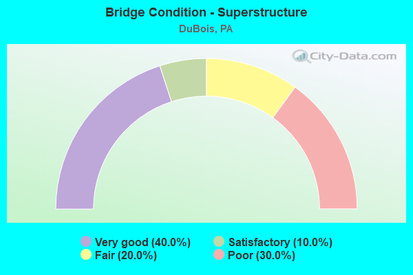
- Bridge Condition - Superstructure
- 40.0%Very good
- 10.0%Satisfactory
- 20.0%Fair
- 30.0%Poor
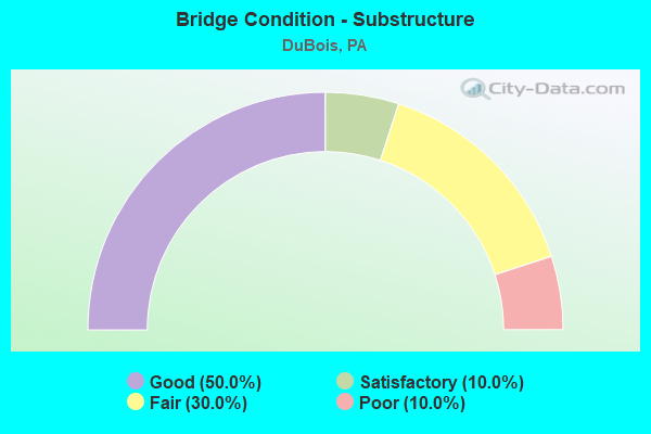
- Bridge Condition - Substructure
- 50.0%Good
- 10.0%Satisfactory
- 30.0%Fair
- 10.0%Poor
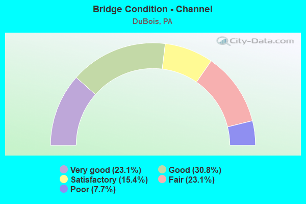
- Bridge Condition - Channel
- 23.1%Very good
- 30.8%Good
- 15.4%Satisfactory
- 23.1%Fair
- 7.7%Poor
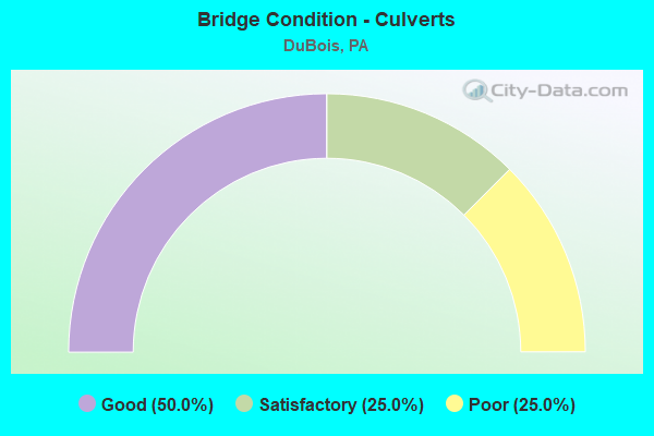
- Bridge Condition - Culverts
- 50.0%Good
- 25.0%Satisfactory
- 25.0%Poor
Find on map >> Show street view
Structure Number: 4203, Location: 3.8 MILE EAST OF SR 1009 (Lat: 40.076458, Lng: -78.271328), Route carried "on" structure: State highway , Year Built: 1941, Status: Open, Structure Length: 1.10m (3.61ft), Average Daily Traffic: 158 (year 2022), Truck Traffic: 11%, Average Future Daily Traffic: 399 (year 2032), Design Load: H 20, Features Intersected: SHERMAN VALLEY RUN, Facility Carried by Structure: SR 1020
Minimum Vertical Clearance: 30+ m (98+ ft), Kilometerpoint: 6.474, Lanes on structure: 2, Owner: State Highway Agency, Approaching Roadway Width: 5.2m (17.1ft), Material/Design: Concrete, Design/Construction: Tee Beam, Number Of Spans In Main Unit: 1, Length of Maximum Span: 10.4m (34.1ft), Curb or Sidewalk Widths: Left: 0.3m (1.0ft), Right: 0.3m (1.0ft), Curb-To-Curb Width: 7.4m (24.3ft), Out-to-Out Width: 8.5m (27.9ft)
Condition: Deck: Poor, Superstructure: Fair, Substructure: Fair, Channel: Fair, Operating Rating: 52.6 metric tons, Method Used To Determine Operating Rating: Load Factor (LF), Inventory Rating: 31.8 metric tons, Method Used To Determine Inventory Rating: Load Factor (LF), Structural Evaluation: Somewhat better than minimum adequacy, Deck Geometry: Somewhat better than minimum adequacy, Waterway Adequacy: Equal to present desirable criteria, Approach Roadway Alignment: Better than present minimum criteria, Length Of Structure Improvement: 1.40m (4.59ft), Designated Inspection Frequency: Every 24 months, Inspection Date: March 2021, Bridge Improvement Cost: $50,000, Roadway Improvement Cost: $264,000, Total Project Cost: $674,000, Deck Structure Type: Concrete Cast-file-Place, Wearing Surface/Protective System: Wearing Surface: Bituminous, Membrane: Preformed Fabric
Find on map >> Show street view
Structure Number: 4553, Location: EVERETT BORO, 1ST STREET (Lat: 40.012992, Lng: -78.372117), Route carried "on" structure: City street , Year Built: 1920, Status: Open, Structure Length: 0.79m (2.59ft), Average Daily Traffic: 205 (year 2021), Truck Traffic: 1%, Average Future Daily Traffic: 257 (year 2041), Features Intersected: BLOODY RUN, Facility Carried by Structure: 1ST STREET
Minimum Vertical Clearance: 30+ m (98+ ft), Kilometerpoint: 0.000, Lanes on structure: 2, Owner: City or Municipal Highway Agency, Approaching Roadway Width: 6.7m (22.0ft), Skew: 2 degrees, Material/Design: Concrete, Design/Construction: Slab, Number Of Spans In Main Unit: 1, Length of Maximum Span: 7.0m (23.0ft), Curb or Sidewalk Widths: Left: 1.2m (3.9ft), Right: 1.5m (4.9ft), Curb-To-Curb Width: 6.9m (22.6ft), Out-to-Out Width: 9.8m (32.2ft)
Condition: Deck: Fair, Superstructure: Fair, Substructure: Fair, Channel: Fair, Operating Rating: 49.0 metric tons, Method Used To Determine Operating Rating: Field evaluation and documented engineering judgment, Inventory Rating: 32.7 metric tons, Method Used To Determine Inventory Rating: Field evaluation and documented engineering judgment, Structural Evaluation: Somewhat better than minimum adequacy, Deck Geometry: Meets minimum limits, Waterway Adequacy: Better than present minimum criteria, Approach Roadway Alignment: Equal to present desirable criteria, Length Of Structure Improvement: 1.00m (3.28ft), Designated Inspection Frequency: Every 24 months, Inspection Date: March 2021, Bridge Improvement Cost: $39,000, Roadway Improvement Cost: $214,000, Total Project Cost: $522,000, Deck Structure Type: Concrete Cast-file-Place, Wearing Surface/Protective System: Wearing Surface: Bituminous
Find on map >> Show street view
Structure Number: 11422, Location: CITY OF DUBOIS (Lat: 41.120103, Lng: -78.759536), Route carried "on" structure: US 219, Year Built: 1962, Year Reconstructed: 1992, Status: Open, Structure Length: 3.23m (10.60ft), Average Daily Traffic: 13,217 (year 2020), Truck Traffic: 5%, Average Future Daily Traffic: 26,193 (year 2041), Design Load: HS 20, Features Intersected: SANDY LICK CREEK
Minimum Vertical Clearance: 30+ m (98+ ft), Kilometerpoint: 66.730, Lanes on structure: 5, Base Highway Network: Yes, Owner: State Highway Agency, Approaching Roadway Width: 17.4m (57.1ft), Material/Design: Prestressed concrete, Design/Construction: Box Beam or Girders - Multiple, Number Of Spans In Main Unit: 2, Length of Maximum Span: 16.2m (53.1ft), Curb or Sidewalk Widths: Left: 1.5m (4.9ft), Right: 1.5m (4.9ft), Curb-To-Curb Width: 17.4m (57.1ft), Out-to-Out Width: 20.9m (68.6ft)
Condition: Deck: Fair, Superstructure: Satisfactory, Substructure: Good, Channel: Good, Operating Rating: 63.5 metric tons, Method Used To Determine Operating Rating: Load Factor (LF), Inventory Rating: 29.0 metric tons, Method Used To Determine Inventory Rating: Load Factor (LF), Structural Evaluation: Equal to present minimum criteria, Deck Geometry: High priority of replacement, Waterway Adequacy: Equal to present minimum criteria, Approach Roadway Alignment: Equal to present desirable criteria, Length Of Structure Improvement: 3.20m (10.50ft), Designated Inspection Frequency: Every 24 months, Inspection Date: May 2021, Bridge Improvement Cost: $65,000, Roadway Improvement Cost: $250,000, Total Project Cost: $882,000, Deck Structure Type: Concrete Cast-file-Place, Wearing Surface/Protective System: Wearing Surface: Bituminous
Find on map >> Show street view
Structure Number: 11423, Location: CITY OF DUBOIS (Lat: 41.124189, Lng: -78.756864), Route carried "on" structure: US 219, Year Built: 1962, Year Reconstructed: 1992, Status: Open, Structure Length: 1.49m (4.89ft), Average Daily Traffic: 13,217 (year 2020), Truck Traffic: 5%, Average Future Daily Traffic: 26,193 (year 2041), Design Load: HS 20, Features Intersected: BEAVER RUN
Minimum Vertical Clearance: 30+ m (98+ ft), Kilometerpoint: 66.730, Lanes on structure: 5, Base Highway Network: Yes, Owner: State Highway Agency, Approaching Roadway Width: 17.4m (57.1ft), Material/Design: Concrete, Design/Construction: Culvert, Number Of Spans In Main Unit: 2, Length of Maximum Span: 7.3m (24.0ft), Curb or Sidewalk Widths: Left: 1.5m (4.9ft), Right: 1.5m (4.9ft), Curb-To-Curb Width: 17.4m (57.1ft), Out-to-Out Width: 20.9m (68.6ft)
Condition: Channel: Satisfactory, Culverts: Satisfactory, Operating Rating: 43.5 metric tons, Method Used To Determine Operating Rating: Allowable Stress (AS), Inventory Rating: 15.4 metric tons, Method Used To Determine Inventory Rating: Allowable Stress (AS), Structural Evaluation: High priority of corrective action, Deck Geometry: High priority of replacement, Waterway Adequacy: Equal to present minimum criteria, Approach Roadway Alignment: Equal to present desirable criteria, Length Of Structure Improvement: 1.50m (4.92ft), Designated Inspection Frequency: Every 24 months, Inspection Date: May 2021, Wearing Surface/Protective System: Wearing Surface: Bituminous
Find on map >> Show street view
Structure Number: 11957, Location: 1.0 MILE E OF SR 219 INT (Lat: 41.121378, Lng: -78.742358), Route carried "on" structure: City street , Year Built: 1975, Year Reconstructed: 2018, Status: Open, Structure Length: 1.22m (4.00ft), Average Daily Traffic: 4,341 (year 2018), Truck Traffic: 1%, Average Future Daily Traffic: 7,975 (year 2038), Design Load: HL 93, Features Intersected: MCCRAKEN RUN, Facility Carried by Structure: BEAVER DR
Minimum Vertical Clearance: 30+ m (98+ ft), Kilometerpoint: 0.000, Lanes on structure: 2, Owner: City or Municipal Highway Agency, Approaching Roadway Width: 7.3m (24.0ft), Material/Design: Prestressed concrete, Design/Construction: Box Beam or Girders - Multiple, Number Of Spans In Main Unit: 1, Length of Maximum Span: 11.3m (37.1ft), Curb or Sidewalk Widths: Left: 0.3m (1.0ft), Right: 0.3m (1.0ft), Curb-To-Curb Width: 8.0m (26.2ft), Out-to-Out Width: 8.6m (28.2ft)
Condition: Deck: Very good, Superstructure: Very good, Substructure: Good, Channel: Very good, Operating Rating: 51.8 metric tons, Method Used To Determine Operating Rating: Assigned ratings based on Load and Resistance Factor Design (LRFD) reported by rating factor (RF) using HL93 loadings, Inventory Rating: 40.2 metric tons, Method Used To Determine Inventory Rating: Assigned ratings based on Load and Resistance Factor Design (LRFD) reported by rating factor (RF) using HL93 loadings, Structural Evaluation: Better than present minimum criteria, Deck Geometry: High priority of corrective action, Waterway Adequacy: Better than present minimum criteria, Approach Roadway Alignment: Equal to present desirable criteria, Length Of Structure Improvement: 1.20m (3.94ft), Designated Inspection Frequency: Every 24 months, Inspection Date: September 2021, Bridge Improvement Cost: $2,000, Roadway Improvement Cost: $5,000, Total Project Cost: $22,000, Deck Structure Type: Concrete Cast-file-Place, Wearing Surface/Protective System: Wearing Surface: Monolithic Concrete
Find on map >> Show street view
Structure Number: 11958, Location: 500FT SOUTH OF MAPLE AVE (Lat: 41.115008, Lng: -78.752767), Route carried "on" structure: City street , Year Built: 1955, Status: Open, Structure Length: 0.94m (3.08ft), Average Daily Traffic: 200 (year 2021), Truck Traffic: 1%, Average Future Daily Traffic: 355 (year 2041), Design Load: HS 20, Features Intersected: REISINGER RUN, Facility Carried by Structure: 4TH STREET
Minimum Vertical Clearance: 30+ m (98+ ft), Kilometerpoint: 0.000, Lanes on structure: 2, Owner: City or Municipal Highway Agency, Approaching Roadway Width: 7.9m (25.9ft), Skew: 3 degrees, Material/Design: Prestressed concrete, Design/Construction: Box Beam or Girders - Multiple, Number Of Spans In Main Unit: 1, Length of Maximum Span: 8.5m (27.9ft), Curb or Sidewalk Widths: Left: 0.2m (0.7ft), Right: 0.2m (0.7ft), Curb-To-Curb Width: 7.8m (25.6ft), Out-to-Out Width: 8.3m (27.2ft)
Condition: Deck: Poor, Superstructure: Poor, Substructure: Fair, Channel: Poor, Operating Rating: 55.3 metric tons, Method Used To Determine Operating Rating: Load Factor (LF), Inventory Rating: 30.8 metric tons, Method Used To Determine Inventory Rating: Load Factor (LF), Structural Evaluation: Meets minimum limits, Deck Geometry: Somewhat better than minimum adequacy, Waterway Adequacy: Better than present minimum criteria, Approach Roadway Alignment: Equal to present desirable criteria, Length Of Structure Improvement: 0.90m (2.95ft), Designated Inspection Frequency: Every 24 months, Inspection Date: September 2021, Bridge Improvement Cost: $7,000, Roadway Improvement Cost: $45,000, Total Project Cost: $95,000, Deck Structure Type: Other, Wearing Surface/Protective System: Wearing Surface: Bituminous
Find on map >> Show street view
Structure Number: 11959, Location: 60 FT S OF WEBER AVE INT (Lat: 41.118764, Lng: -78.767250), Route carried "on" structure: City street , Year Built: 1930, Status: Open, Structure Length: 1.01m (3.31ft), Average Daily Traffic: 75 (year 2021), Average Future Daily Traffic: 137 (year 2041), Design Load: HS 20, Features Intersected: PENTZ RUN, Facility Carried by Structure: S FRANKLIN STREET
Minimum Vertical Clearance: 30+ m (98+ ft), Kilometerpoint: 0.000, Lanes on structure: 1, Owner: City or Municipal Highway Agency, Approaching Roadway Width: 4.0m (13.1ft), Skew: 1 degrees, Material/Design: Concrete, Design/Construction: Slab, Number Of Spans In Main Unit: 1, Length of Maximum Span: 8.5m (27.9ft), Curb or Sidewalk Widths: Left: 0.0m, Right: 1.6m (5.2ft), Curb-To-Curb Width: 4.7m (15.4ft), Out-to-Out Width: 6.8m (22.3ft)
Condition: Deck: Poor, Superstructure: Poor, Substructure: Poor, Channel: Fair, Operating Rating: 55.3 metric tons, Method Used To Determine Operating Rating: Field evaluation and documented engineering judgment, Inventory Rating: 32.7 metric tons, Method Used To Determine Inventory Rating: Field evaluation and documented engineering judgment, Structural Evaluation: Meets minimum limits, Deck Geometry: Better than present minimum criteria, Waterway Adequacy: Better than present minimum criteria, Approach Roadway Alignment: Equal to present desirable criteria, Length Of Structure Improvement: 1.00m (3.28ft), Designated Inspection Frequency: Every 24 months, Inspection Date: September 2021, Bridge Improvement Cost: $11,000, Roadway Improvement Cost: $50,000, Total Project Cost: $143,000, Wearing Surface/Protective System: Wearing Surface: Bituminous
Find on map >> Show street view
Structure Number: 1196, Location: 175 EAST OF N FRANKLIN ST (Lat: 41.120897, Lng: -78.765000), Route carried "on" structure: City street , Year Built: 1993, Status: Open, Structure Length: 0.67m (2.20ft), Average Daily Traffic: 3,000 (year 2021), Truck Traffic: 1%, Average Future Daily Traffic: 5,317 (year 2041), Design Load: HS 25 or greater, Features Intersected: PENTZ RUN, Facility Carried by Structure: LONG AVENUE
Minimum Vertical Clearance: 30+ m (98+ ft), Kilometerpoint: 0.000, Lanes on structure: 2, Owner: City or Municipal Highway Agency, Approaching Roadway Width: 11.6m (38.1ft), Skew: 1 degrees, Material/Design: Concrete, Design/Construction: Culvert, Number Of Spans In Main Unit: 1, Length of Maximum Span: 6.1m (20.0ft), Curb or Sidewalk Widths: Left: 3.6m (11.8ft), Right: 3.4m (11.2ft), Curb-To-Curb Width: 11.5m (37.7ft), Out-to-Out Width: 20.2m (66.3ft)
Condition: Channel: Good, Culverts: Poor, Operating Rating: 57.2 metric tons, Method Used To Determine Operating Rating: Load Factor (LF), Inventory Rating: 34.5 metric tons, Method Used To Determine Inventory Rating: Load Factor (LF), Structural Evaluation: Meets minimum limits, Deck Geometry: Somewhat better than minimum adequacy, Waterway Adequacy: Better than present minimum criteria, Approach Roadway Alignment: Equal to present desirable criteria, Length Of Structure Improvement: 0.60m (1.97ft), Designated Inspection Frequency: Every 24 months, Inspection Date: September 2021, Wearing Surface/Protective System: Wearing Surface: Bituminous, Membrane: Other, Deck Protection: Epoxy Coated Reinforcing
Find on map >> Show street view
Structure Number: 11962, Location: 500 FT NE OF T350 (Lat: 41.129300, Lng: -78.777000), Route carried "on" structure: City street , Year Built: 1970, Year Reconstructed: 2014, Status: Open, Structure Length: 3.54m (11.61ft), Average Daily Traffic: 35 (year 2021), Truck Traffic: 10%, Average Future Daily Traffic: 45 (year 2041), Design Load: HS 20, Features Intersected: SANDY LICK CREEK, Facility Carried by Structure: S.T.P. ACCESS ROAD
Minimum Vertical Clearance: 30+ m (98+ ft), Kilometerpoint: 0.000, Lanes on structure: 1, Owner: City or Municipal Highway Agency, Approaching Roadway Width: 4.0m (13.1ft), Material/Design: Steel, Design/Construction: Girder and Floorbeam System, Number Of Spans In Main Unit: 1, Length of Maximum Span: 34.4m (112.9ft), Curb or Sidewalk Widths: Left: 0.3m (1.0ft), Right: 0.3m (1.0ft), Curb-To-Curb Width: 3.0m (9.8ft), Out-to-Out Width: 4.4m (14.4ft)
Condition: Deck: Fair, Superstructure: Poor, Substructure: Satisfactory, Channel: Very good, Operating Rating: 43.5 metric tons, Method Used To Determine Operating Rating: Load Factor (LF), Inventory Rating: 26.3 metric tons, Method Used To Determine Inventory Rating: Load Factor (LF), Structural Evaluation: Meets minimum limits, Deck Geometry: High priority of replacement, Waterway Adequacy: Equal to present desirable criteria, Approach Roadway Alignment: Better than present minimum criteria, Length Of Structure Improvement: 3.50m (11.48ft), Designated Inspection Frequency: Every 24 months, Critical Feature Inspection Frequency: Every 12 months, Other Special Inspection Frequency: Every 12 months, Inspection Date: April 2021, Critical Feature Inspection Date: April 2021, Other Special Inspection Date: April 2021, Bridge Improvement Cost: $8,000, Roadway Improvement Cost: $24,000, Total Project Cost: $110,000, Deck Structure Type: Concrete Cast-file-Place, Wearing Surface/Protective System: Wearing Surface: Bituminous
Find on map >> Show street view
Structure Number: 42031, Location: DUBOIS (Lat: 41.112197, Lng: -78.769153), Route carried "on" structure: US 219, Year Built: 2003, Status: Open, Structure Length: 14.26m (46.78ft), Average Daily Traffic: 11,574 (year 2021), Truck Traffic: 8%, Average Future Daily Traffic: 15,450 (year 2041), Design Load: HL 93, Features Intersected: BUFFALO & PITTSBURGH RR
Minimum Vertical Clearance: 30+ m (98+ ft), Kilometerpoint: 65.027, Lanes on structure: 3, Base Highway Network: Yes, Owner: State Highway Agency, Approaching Roadway Width: 11.9m (39.0ft), Skew: 2 degrees, Material/Design: Steel continuous, Design/Construction: Stringer/Multi-beam, Number Of Spans In Main Unit: 3, Length of Maximum Span: 64.0m (210.0ft), Curb or Sidewalk Widths: Left: 0.2m (0.7ft), Right: 1.5m (4.9ft), Curb-To-Curb Width: 12.0m (39.4ft), Out-to-Out Width: 14.8m (48.6ft)
Condition: Deck: Good, Superstructure: Very good, Substructure: Good, Operating Rating: 90.7 metric tons, Method Used To Determine Operating Rating: Load Factor (LF), Inventory Rating: 54.4 metric tons, Method Used To Determine Inventory Rating: Load Factor (LF), Structural Evaluation: Better than present minimum criteria, Deck Geometry: Meets minimum limits, Underclear: High priority of corrective action, Approach Roadway Alignment: Equal to present desirable criteria, Length Of Structure Improvement: 15.20m (49.87ft), Designated Inspection Frequency: Every 24 months, Inspection Date: May 2021, Deck Structure Type: Concrete Cast-file-Place, Wearing Surface/Protective System: Wearing Surface: Monolithic Concrete, Deck Protection: Epoxy Coated Reinforcing
Find on map >> Show street view
Structure Number: 43018, Location: DUBOIS SANDY TWP LINE (Lat: 41.130167, Lng: -78.766694), Route carried "on" structure: US 219, Year Built: 2005, Status: Open, Structure Length: 1.10m (3.61ft), Average Daily Traffic: 12,148 (year 2020), Truck Traffic: 7%, Average Future Daily Traffic: 16,397 (year 2041), Design Load: HL 93, Features Intersected: CLEAR RUN
Minimum Vertical Clearance: 30+ m (98+ ft), Kilometerpoint: 68.318, Lanes on structure: 2, Base Highway Network: Yes, Owner: State Highway Agency, Approaching Roadway Width: 8.5m (27.9ft), Material/Design: Prestressed concrete, Design/Construction: Box Beam or Girders - Multiple, Number Of Spans In Main Unit: 1, Length of Maximum Span: 10.4m (34.1ft), Curb or Sidewalk Widths: Left: 0.1m (0.3ft), Right: 1.5m (4.9ft), Curb-To-Curb Width: 12.1m (39.7ft), Out-to-Out Width: 14.8m (48.6ft)
Condition: Deck: Good, Superstructure: Very good, Substructure: Good, Channel: Good, Inventory Rating: 69.9 metric tons, Method Used To Determine Inventory Rating: Load Factor (LF), Structural Evaluation: Better than present minimum criteria, Deck Geometry: Somewhat better than minimum adequacy, Waterway Adequacy: Equal to present minimum criteria, Approach Roadway Alignment: Equal to present desirable criteria, Length Of Structure Improvement: 1.70m (5.58ft), Designated Inspection Frequency: Every 24 months, Inspection Date: June 2021, Deck Structure Type: Concrete Cast-file-Place, Wearing Surface/Protective System: Wearing Surface: Monolithic Concrete, Deck Protection: Epoxy Coated Reinforcing
Find on map >> Show street view
Structure Number: 4553, Location: CITY OF DUBOIS (Lat: 41.125661, Lng: -78.763733), Route carried "on" structure: Spur State highway , Year Built: 2009, Status: Open, Structure Length: 2.99m (9.81ft), Average Daily Traffic: 9,487 (year 2022), Truck Traffic: 2%, Average Future Daily Traffic: 10,388 (year 2041), Design Load: HL 93, Features Intersected: SANDY LICK CREEK, Facility Carried by Structure: SR 4019
Minimum Vertical Clearance: 30+ m (98+ ft), Kilometerpoint: 0.010, Lanes on structure: 2, Owner: State Highway Agency, Approaching Roadway Width: 12.8m (42.0ft), Material/Design: Prestressed concrete continuous, Design/Construction: Box Beam or Girders - Single/Spread, Number Of Spans In Main Unit: 2, Length of Maximum Span: 14.9m (48.9ft), Curb or Sidewalk Widths: Left: 0.0m, Right: 2.4m (7.9ft), Curb-To-Curb Width: 12.8m (42.0ft), Out-to-Out Width: 16.2m (53.1ft)
Condition: Deck: Good, Superstructure: Very good, Substructure: Good, Channel: Very good, Operating Rating: 79.8 metric tons, Method Used To Determine Operating Rating: Load Factor (LF), Inventory Rating: 47.2 metric tons, Method Used To Determine Inventory Rating: Load Factor (LF), Structural Evaluation: Better than present minimum criteria, Deck Geometry: Somewhat better than minimum adequacy, Waterway Adequacy: Equal to present desirable criteria, Approach Roadway Alignment: Equal to present desirable criteria, Designated Inspection Frequency: Every 24 months, Inspection Date: July 2021, Deck Structure Type: Concrete Cast-file-Place, Wearing Surface/Protective System: Wearing Surface: Monolithic Concrete, Deck Protection: Epoxy Coated Reinforcing
Find on map >> Show street view
Structure Number: 46323, Location: 1000 FT NW OF US 219 INT (Lat: 41.118836, Lng: -78.766794), Route carried "on" structure: City street , Year Built: 2010, Status: Open, Structure Length: 0.73m (2.40ft), Average Daily Traffic: 500 (year 2021), Truck Traffic: 1%, Average Future Daily Traffic: 550 (year 2041), Design Load: HL 93, Features Intersected: PENTZ RUN, Facility Carried by Structure: WEBER AVENUE
Minimum Vertical Clearance: 30+ m (98+ ft), Kilometerpoint: 0.000, Lanes on structure: 2, Owner: City or Municipal Highway Agency, Approaching Roadway Width: 7.3m (24.0ft), Material/Design: Concrete, Design/Construction: Culvert, Number Of Spans In Main Unit: 1, Length of Maximum Span: 6.4m (21.0ft), Curb or Sidewalk Widths: Left: 1.5m (4.9ft), Right: 1.8m (5.9ft), Curb-To-Curb Width: 7.2m (23.6ft), Out-to-Out Width: 11.0m (36.1ft)
Condition: Channel: Good, Culverts: Good, Operating Rating: 61.7 metric tons, Method Used To Determine Operating Rating: Load and Resistance Factor (LRFR), Inventory Rating: 48.1 metric tons, Method Used To Determine Inventory Rating: Load and Resistance Factor (LRFR), Structural Evaluation: Better than present minimum criteria, Deck Geometry: Meets minimum limits, Waterway Adequacy: Better than present minimum criteria, Approach Roadway Alignment: Equal to present desirable criteria, Designated Inspection Frequency: Every 24 months, Inspection Date: September 2021, Wearing Surface/Protective System: Wearing Surface: Bituminous, Membrane: Preformed Fabric, Deck Protection: Epoxy Coated Reinforcing
Find on map >> Show street view
Structure Number: 46324, Location: 150 FT NW OF JARED ST (Lat: 41.119900, Lng: -78.765900), Route carried "on" structure: City street , Year Built: 2010, Status: Open, Structure Length: 0.70m (2.30ft), Average Daily Traffic: 1,175 (year 2021), Truck Traffic: 1%, Average Future Daily Traffic: 1,300 (year 2041), Design Load: HL 93, Features Intersected: PENTZ RUN, Facility Carried by Structure: WASHINGTON AVENUE
Minimum Vertical Clearance: 30+ m (98+ ft), Kilometerpoint: 0.000, Lanes on structure: 2, Owner: City or Municipal Highway Agency, Approaching Roadway Width: 9.4m (30.8ft), Material/Design: Concrete, Design/Construction: Culvert, Number Of Spans In Main Unit: 1, Length of Maximum Span: 6.4m (21.0ft), Curb or Sidewalk Widths: Left: 2.7m (8.9ft), Right: 2.6m (8.5ft), Curb-To-Curb Width: 9.3m (30.5ft), Out-to-Out Width: 15.3m (50.2ft)
Condition: Channel: Satisfactory, Culverts: Good, Operating Rating: 55.3 metric tons, Method Used To Determine Operating Rating: Load and Resistance Factor (LRFR), Inventory Rating: 42.6 metric tons, Method Used To Determine Inventory Rating: Load and Resistance Factor (LRFR), Structural Evaluation: Better than present minimum criteria, Deck Geometry: Somewhat better than minimum adequacy, Waterway Adequacy: Better than present minimum criteria, Approach Roadway Alignment: Equal to present desirable criteria, Designated Inspection Frequency: Every 24 months, Inspection Date: September 2021, Wearing Surface/Protective System: Wearing Surface: Bituminous, Membrane: Preformed Fabric, Deck Protection: Epoxy Coated Reinforcing