Bridge Statistics for Dyer, Indiana (IN)
Condition, Traffic, Stress, Structural Evaluation, Project Costs
- National Bridge Inventory (NBI) Statistics
- 16Number of bridges
- 210ft / 64.0mTotal length
- $761,000Total costs
- 217,915Total average daily traffic
- 19,479Total average daily truck traffic
- National Bridge Inventory (NBI) Registered Bridges for Dyer
- No street view available for this location
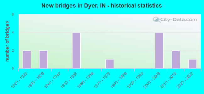
- New bridges - historical statistics
- 21920-1929
- 21930-1939
- 41950-1959
- 11970-1979
- 42000-2009
- 22010-2019
- 12020-2022
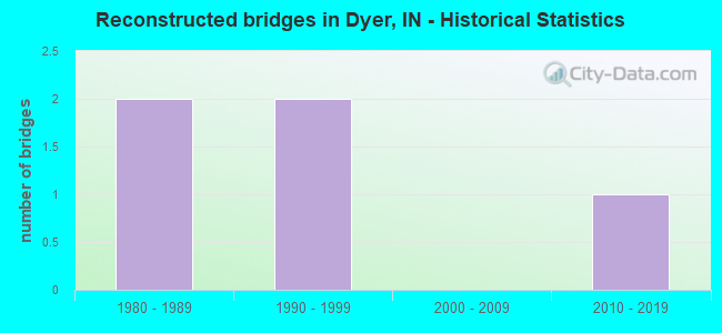
- Reconstructed bridges - Historical Statistics
- 21980-1989
- 21990-1999
- 02000-2009
- 12010-2019

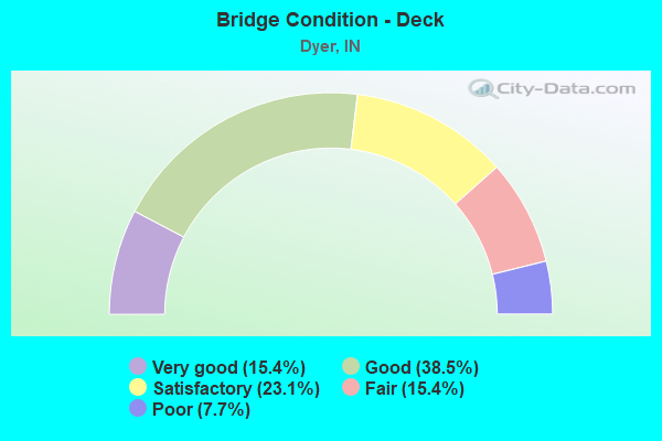
- Bridge Condition - Deck
- 15.4%Very good
- 38.5%Good
- 23.1%Satisfactory
- 15.4%Fair
- 7.7%Poor
- Bridge Condition - Superstructure
- 23.1%Very good
- 23.1%Good
- 30.8%Satisfactory
- 15.4%Fair
- 7.7%Poor
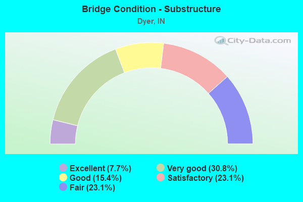
- Bridge Condition - Substructure
- 7.7%Excellent
- 30.8%Very good
- 15.4%Good
- 23.1%Satisfactory
- 23.1%Fair
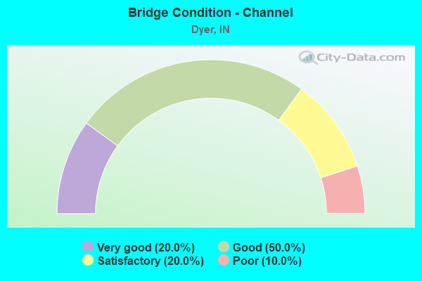
- Bridge Condition - Channel
- 20.0%Very good
- 50.0%Good
- 20.0%Satisfactory
- 10.0%Poor
Find on map >> Show street view
Structure Number: 405, Location: 02.24 S SR 25 (Lat: 41.205111, Lng: -85.869850), Route carried "on" structure: State highway 15, Year Built: 1928, Year Reconstructed: 1993, Status: Open, Structure Length: 1.62m (5.31ft), Average Daily Traffic: 10,947 (year 2018), Truck Traffic: 21%, Average Future Daily Traffic: 13,846 (year 2030), Design Load: HS 20, Features Intersected: WALNUT CREEK
Minimum Vertical Clearance: 30+ m (98+ ft), Kilometerpoint: 18.314, Lanes on structure: 2, Owner: State Highway Agency, Approaching Roadway Width: 13.4m (44.0ft), Skew: 4 degrees, Material/Design: Concrete continuous, Design/Construction: Slab, Number Of Spans In Main Unit: 2, Length of Maximum Span: 7.8m (25.6ft), Curb-To-Curb Width: 13.3m (43.6ft), Out-to-Out Width: 14.2m (46.6ft)
Condition: Deck: Fair, Superstructure: Fair, Substructure: Satisfactory, Channel: Good, Operating Rating: 56.1 metric tons, Method Used To Determine Operating Rating: Load and Resistance Factor Rating (LRFR) rating reported by rating factor(RF) method using HL-93 loadings, Inventory Rating: 43.4 metric tons, Method Used To Determine Inventory Rating: Load and Resistance Factor Rating (LRFR) rating reported by rating factor(RF) method using HL-93 loadings, Structural Evaluation: Somewhat better than minimum adequacy, Deck Geometry: Somewhat better than minimum adequacy, Waterway Adequacy: Equal to present desirable criteria, Approach Roadway Alignment: Equal to present desirable criteria, Designated Inspection Frequency: Every 24 months, Inspection Date: June 2021, Deck Structure Type: Concrete Cast-file-Place, Wearing Surface/Protective System: Wearing Surface: Latex Concrete
Find on map >> Show street view
Structure Number: 711, Location: 04.26 N SR 44 (Lat: 39.696619, Lng: -84.927511), Route carried "on" structure: US 27, Year Built: 1930, Year Reconstructed: 1997, Status: Open, Structure Length: 1.57m (5.15ft), Average Daily Traffic: 5,748 (year 2004), Truck Traffic: 5%, Average Future Daily Traffic: 7,960 (year 2030), Design Load: H 20, Features Intersected: RICHLAND CREEK
Minimum Vertical Clearance: 30+ m (98+ ft), Kilometerpoint: 19.521, Lanes on structure: 2, Base Highway Network: Yes (, Subroute: 1), Owner: State Highway Agency, Approaching Roadway Width: 12.2m (40.0ft), Material/Design: Concrete continuous, Design/Construction: Slab, Number Of Spans In Main Unit: 2, Length of Maximum Span: 7.3m (24.0ft), Curb-To-Curb Width: 12.3m (40.4ft), Out-to-Out Width: 13.1m (43.0ft)
Condition: Deck: Satisfactory, Superstructure: Satisfactory, Substructure: Satisfactory, Channel: Good, Operating Rating: 40.5 metric tons, Method Used To Determine Operating Rating: Load and Resistance Factor Rating (LRFR) rating reported by rating factor(RF) method using HL-93 loadings, Inventory Rating: 31.1 metric tons, Method Used To Determine Inventory Rating: Load and Resistance Factor Rating (LRFR) rating reported by rating factor(RF) method using HL-93 loadings, Structural Evaluation: Equal to present minimum criteria, Deck Geometry: Somewhat better than minimum adequacy, Waterway Adequacy: Superior to present desirable criteria, Approach Roadway Alignment: Equal to present desirable criteria, Designated Inspection Frequency: Every 24 months, Inspection Date: April 2021, Deck Structure Type: Concrete Cast-file-Place, Wearing Surface/Protective System: Wearing Surface: Monolithic Concrete, Deck Protection: Epoxy Coated Reinforcing
Find on map >> Show street view
Structure Number: 807, Location: 01.10 W US 41 (Lat: 41.491269, Lng: -87.491819), Route carried "on" structure: US 30, Year Built: 1922, Year Reconstructed: 1997, Status: Open, Structure Length: 1.13m (3.71ft), Average Daily Traffic: 31,823 (year 2004), Truck Traffic: 5%, Average Future Daily Traffic: 44,838 (year 2030), Design Load: HS 20, Features Intersected: DYER DITCH
Minimum Vertical Clearance: 30+ m (98+ ft), Kilometerpoint: 2.816, Lanes on structure: 5, Base Highway Network: Yes (, Subroute: 1), Owner: State Highway Agency, Approaching Roadway Width: 21.0m (68.9ft), Skew: 20 degrees, Material/Design: Prestressed concrete, Design/Construction: Box Beam or Girders - Multiple, Number Of Spans In Main Unit: 1, Length of Maximum Span: 10.7m (35.1ft), Curb or Sidewalk Widths: Left: 1.7m (5.6ft), Right: 1.7m (5.6ft), Curb-To-Curb Width: 21.0m (68.9ft), Out-to-Out Width: 25.5m (83.7ft)
Condition: Deck: Satisfactory, Superstructure: Fair, Substructure: Fair, Channel: Very good, Operating Rating: 43.4 metric tons, Method Used To Determine Operating Rating: Load and Resistance Factor Rating (LRFR) rating reported by rating factor(RF) method using HL-93 loadings, Inventory Rating: 28.2 metric tons, Method Used To Determine Inventory Rating: Load and Resistance Factor Rating (LRFR) rating reported by rating factor(RF) method using HL-93 loadings, Structural Evaluation: Somewhat better than minimum adequacy, Deck Geometry: Meets minimum limits, Waterway Adequacy: Equal to present desirable criteria, Approach Roadway Alignment: Equal to present desirable criteria, Designated Inspection Frequency: Every 24 months, Inspection Date: March 2022, Deck Structure Type: Concrete Cast-file-Place, Wearing Surface/Protective System: Wearing Surface: Monolithic Concrete, Deck Protection: Epoxy Coated Reinforcing
Find on map >> Show street view
Structure Number: 1569, Location: 02.94 N I-80 (Lat: 41.616839, Lng: -87.508903), Route carried "on" structure: US 41, Year Built: 1974, Year Reconstructed: 2018, Status: Open, Structure Length: 27.25m (89.40ft), Average Daily Traffic: 22,923 (year 2004), Truck Traffic: 5%, Average Future Daily Traffic: 32,299 (year 2030), Design Load: HS 20+Mod, Features Intersected: CONRAIL RR, IHB RR, & 4
Minimum Vertical Clearance: 30+ m (98+ ft), Kilometerpoint: 52.159, Lanes on structure: 4, Lanes under structure: 9, Owner: State Highway Agency, Approaching Roadway Width: 15.9m (52.2ft), Skew: 32 degrees, Material/Design: Steel continuous, Design/Construction: Stringer/Multi-beam, Number Of Spans In Main Unit: 10, Length of Maximum Span: 30.5m (100.1ft), Curb or Sidewalk Widths: Left: 1.4m (4.6ft), Right: 1.4m (4.6ft), Curb-To-Curb Width: 15.9m (52.2ft), Out-to-Out Width: 20.9m (68.6ft)
Condition: Deck: Good, Superstructure: Satisfactory, Substructure: Good, Operating Rating: 66.3 metric tons, Method Used To Determine Operating Rating: Load Factor (LF), Inventory Rating: 39.7 metric tons, Method Used To Determine Inventory Rating: Load Factor (LF), Structural Evaluation: Equal to present minimum criteria, Deck Geometry: Meets minimum limits, Underclear: High priority of corrective action, Approach Roadway Alignment: Equal to present desirable criteria, Designated Inspection Frequency: Every 24 months, Inspection Date: January 2021, Deck Structure Type: Concrete Cast-file-Place, Wearing Surface/Protective System: Wearing Surface: Monolithic Concrete, Deck Protection: Epoxy Coated Reinforcing
Find on map >> Show street view
Structure Number: 1625, Location: 00.78 S SR 18 (Lat: 40.591439, Lng: -86.868889), Route carried "on" structure: State highway 43, Year Built: 1930, Status: Open, Structure Length: 1.19m (3.90ft), Average Daily Traffic: 9,010 (year 2006), Truck Traffic: 11%, Average Future Daily Traffic: 12,479 (year 2033), Design Load: H 20, Features Intersected: DRAINAGE DITCH
Minimum Vertical Clearance: 30+ m (98+ ft), Kilometerpoint: 3.299, Lanes on structure: 2, Base Highway Network: Yes (, Subroute: 1), Owner: State Highway Agency, Approaching Roadway Width: 9.1m (29.9ft), Skew: 1 degrees, Material/Design: Concrete, Design/Construction: Culvert, Number Of Spans In Main Unit: 1, Length of Maximum Span: 11.0m (36.1ft), Curb-To-Curb Width: 9.1m (29.9ft), Out-to-Out Width: 9.1m (29.9ft)
Condition: Channel: Satisfactory, Culverts: Satisfactory, Operating Rating: 89.8 metric tons, Method Used To Determine Operating Rating: Load Factor (LF), Inventory Rating: 89.8 metric tons, Method Used To Determine Inventory Rating: Load Factor (LF), Structural Evaluation: Equal to present minimum criteria, Deck Geometry: High priority of corrective action, Waterway Adequacy: Superior to present desirable criteria, Approach Roadway Alignment: Equal to present desirable criteria, Designated Inspection Frequency: Every 24 months, Inspection Date: March 2021
Find on map >> Show street view
Structure Number: 4664, Location: 01.35 W SR 51 (Lat: 41.590211, Lng: -87.266258), Route carried "on" structure: City street , Year Built: 1956, Year Reconstructed: 1986, Status: Open, Structure Length: 6.71m (22.01ft), Average Daily Traffic: 3,498 (year 2015), Truck Traffic: 5%, Average Future Daily Traffic: 7,533 (year 2031), Design Load: HS 20, Features Intersected: I-90 EB/WB, Facility Carried by Structure: LAKE STREET
Minimum Vertical Clearance: 30+ m (98+ ft), Kilometerpoint: 0.000, Lanes on structure: 2, Lanes under structure: 4, Owner: State Toll Authority, Approaching Roadway Width: 37.8m (124.0ft), Material/Design: Steel, Design/Construction: Stringer/Multi-beam, Number Of Spans In Main Unit: 4, Length of Maximum Span: 20.1m (65.9ft), Curb or Sidewalk Widths: Left: 1.2m (3.9ft), Right: 1.2m (3.9ft), Curb-To-Curb Width: 9.1m (29.9ft), Out-to-Out Width: 12.2m (40.0ft)
Condition: Deck: Fair, Superstructure: Satisfactory, Substructure: Fair, Operating Rating: 70.1 metric tons, Method Used To Determine Operating Rating: Load Factor (LF), Inventory Rating: 42.0 metric tons, Method Used To Determine Inventory Rating: Load Factor (LF), Structural Evaluation: Somewhat better than minimum adequacy, Deck Geometry: Meets minimum limits, Underclear: Somewhat better than minimum adequacy, Approach Roadway Alignment: Equal to present minimum criteria, Designated Inspection Frequency: Every 24 months, Other Special Inspection Frequency: Every 24 months, Inspection Date: July 2021, Other Special Inspection Date: July 2021, Deck Structure Type: Concrete Cast-file-Place, Wearing Surface/Protective System: Wearing Surface: Latex Concrete
Find on map >> Show street view
Structure Number: 4500152, Location: 00.10 W. of CALUMET AVE (Lat: 41.508169, Lng: -87.510089), Route carried "on" structure: City street , Year Built: 1955, Status: Posted for load, Structure Length: 2.51m (8.23ft), Average Daily Traffic: 5,782 (year 2019), Truck Traffic: 3%, Average Future Daily Traffic: 7,197 (year 2041), Design Load: HS 20, Features Intersected: HART DITCH, Facility Carried by Structure: 213TH STREET
Minimum Vertical Clearance: 30+ m (98+ ft), Kilometerpoint: 0.000, Lanes on structure: 2, Owner: County Highway Agency, Approaching Roadway Width: 9.1m (29.9ft), Material/Design: Concrete continuous, Design/Construction: Slab, Number Of Spans In Main Unit: 3, Length of Maximum Span: 9.7m (31.8ft), Curb or Sidewalk Widths: Left: 0.9m (3.0ft), Right: 0.9m (3.0ft), Curb-To-Curb Width: 7.4m (24.3ft), Out-to-Out Width: 9.8m (32.2ft)
Condition: Deck: Poor, Superstructure: Poor, Substructure: Satisfactory, Channel: Satisfactory, Operating Rating: 24.8 metric tons, Method Used To Determine Operating Rating: Field evaluation and documented engineering judgment, Inventory Rating: 14.9 metric tons, Method Used To Determine Inventory Rating: Field evaluation and documented engineering judgment, Structural Evaluation: High priority of corrective action, Deck Geometry: High priority of replacement, Waterway Adequacy: Superior to present desirable criteria, Approach Roadway Alignment: Equal to present desirable criteria, Bridge Posting: Required (Relationship of Operating Rating to Maximum Legal Load: 20.0 - 29.9% below), Length Of Structure Improvement: 2.53m (8.30ft), Designated Inspection Frequency: Every 12 months, Inspection Date: August 2021, Bridge Improvement Cost: $655,000, Roadway Improvement Cost: $47,000, Total Project Cost: $702,000 ( Estimate for 2021), Deck Structure Type: Concrete Cast-file-Place, Wearing Surface/Protective System: Wearing Surface: Bituminous
Find on map >> Show street view
Structure Number: 4500154, Location: 00.10 E. of HART ST (Lat: 41.495500, Lng: -87.518889), Route carried "on" structure: City street , Year Built: 2003, Status: Open, Structure Length: 2.48m (8.14ft), Average Daily Traffic: 1,293 (year 2012), Truck Traffic: 2%, Average Future Daily Traffic: 1,709 (year 2040), Design Load: HS 20, Features Intersected: HART DITCH, Facility Carried by Structure: KEILMAN STREET
Minimum Vertical Clearance: 30+ m (98+ ft), Kilometerpoint: 0.000, Lanes on structure: 2, Owner: County Highway Agency, Approaching Roadway Width: 8.2m (26.9ft), Material/Design: Concrete continuous, Design/Construction: Slab, Number Of Spans In Main Unit: 2, Length of Maximum Span: 12.4m (40.7ft), Curb or Sidewalk Widths: Left: 2.0m (6.6ft), Right: 2.0m (6.6ft), Curb-To-Curb Width: 8.3m (27.2ft), Out-to-Out Width: 12.9m (42.3ft)
Condition: Deck: Satisfactory, Superstructure: Satisfactory, Substructure: Fair, Channel: Poor, Operating Rating: 54.5 metric tons, Method Used To Determine Operating Rating: Field evaluation and documented engineering judgment, Inventory Rating: 32.7 metric tons, Method Used To Determine Inventory Rating: Field evaluation and documented engineering judgment, Structural Evaluation: Somewhat better than minimum adequacy, Deck Geometry: Meets minimum limits, Waterway Adequacy: Superior to present desirable criteria, Approach Roadway Alignment: Equal to present desirable criteria, Length Of Structure Improvement: 2.47m (8.10ft), Designated Inspection Frequency: Every 24 months, Inspection Date: August 2020, Bridge Improvement Cost: $22,000, Roadway Improvement Cost: $37,000, Total Project Cost: $59,000 ( Estimate for 2020), Deck Structure Type: Concrete Cast-file-Place, Wearing Surface/Protective System: Wearing Surface: Monolithic Concrete
Find on map >> Show street view
Structure Number: 4500204, Location: 00.40 N OF US 30 (Lat: 41.498889, Lng: -87.509169), Route carried "on" structure: County highway , Year Built: 2004, Status: Open, Structure Length: 1.61m (5.28ft), Average Daily Traffic: 22,835 (year 2019), Truck Traffic: 10%, Average Future Daily Traffic: 28,142 (year 2040), Design Load: HS 20, Features Intersected: NS RAILROAD, Facility Carried by Structure: CALUMET AVENUE
Minimum Vertical Clearance: 30+ m (98+ ft), Kilometerpoint: 0.000, Lanes on structure: 4, Owner: County Highway Agency, Approaching Roadway Width: 15.2m (49.9ft), Material/Design: Prestressed concrete, Design/Construction: Stringer/Multi-beam, Number Of Spans In Main Unit: 1, Length of Maximum Span: 15.3m (50.2ft), Curb or Sidewalk Widths: Left: 2.0m (6.6ft), Right: 2.0m (6.6ft), Curb-To-Curb Width: 15.2m (49.9ft), Out-to-Out Width: 20.1m (65.9ft)
Condition: Deck: Good, Superstructure: Very good, Substructure: Very good, Operating Rating: 62.0 metric tons, Method Used To Determine Operating Rating: Load Factor (LF), Inventory Rating: 37.1 metric tons, Method Used To Determine Inventory Rating: Load Factor (LF), Structural Evaluation: Equal to present desirable criteria, Deck Geometry: High priority of corrective action, Underclear: Superior to present desirable criteria, Approach Roadway Alignment: Equal to present desirable criteria, Designated Inspection Frequency: Every 24 months, Inspection Date: August 2020, Deck Structure Type: Concrete Cast-file-Place, Wearing Surface/Protective System: Wearing Surface: Monolithic Concrete, Deck Protection: Epoxy Coated Reinforcing
Find on map >> Show street view
Structure Number: 4500205, Location: 00.30 N. of US 30 (Lat: 41.497989, Lng: -87.509161), Route carried "on" structure: County highway , Year Built: 2004, Status: Open, Structure Length: 4.58m (15.03ft), Average Daily Traffic: 22,835 (year 2019), Truck Traffic: 10%, Average Future Daily Traffic: 28,142 (year 2040), Design Load: HS 20, Features Intersected: EJ&E RAILROAD, Facility Carried by Structure: CALUMET AVENUE
Minimum Vertical Clearance: 30+ m (98+ ft), Kilometerpoint: 0.000, Lanes on structure: 4, Owner: County Highway Agency, Approaching Roadway Width: 15.2m (49.9ft), Skew: 1 degrees, Material/Design: Prestressed concrete, Design/Construction: Tee Beam, Number Of Spans In Main Unit: 1, Length of Maximum Span: 45.0m (147.6ft), Curb or Sidewalk Widths: Left: 2.0m (6.6ft), Right: 2.0m (6.6ft), Curb-To-Curb Width: 15.2m (49.9ft), Out-to-Out Width: 20.1m (65.9ft)
Condition: Deck: Good, Superstructure: Good, Substructure: Very good, Operating Rating: 92.6 metric tons, Method Used To Determine Operating Rating: Load Factor (LF), Inventory Rating: 38.9 metric tons, Method Used To Determine Inventory Rating: Load Factor (LF), Structural Evaluation: Better than present minimum criteria, Deck Geometry: High priority of corrective action, Underclear: Better than present minimum criteria, Approach Roadway Alignment: Equal to present desirable criteria, Designated Inspection Frequency: Every 24 months, Inspection Date: August 2020, Deck Structure Type: Concrete Cast-file-Place, Wearing Surface/Protective System: Wearing Surface: Monolithic Concrete, Deck Protection: Epoxy Coated Reinforcing
Find on map >> Show street view
Structure Number: 4500206, Location: 01.20 N. of US 30 (Lat: 41.510089, Lng: -87.509169), Route carried "on" structure: County highway , Year Built: 2004, Status: Open, Structure Length: 3.72m (12.20ft), Average Daily Traffic: 22,835 (year 2019), Truck Traffic: 10%, Average Future Daily Traffic: 28,142 (year 2040), Design Load: HS 20, Features Intersected: HART DITCH, Facility Carried by Structure: CALUMET AVENUE
Minimum Vertical Clearance: 30+ m (98+ ft), Kilometerpoint: 0.000, Lanes on structure: 4, Owner: County Highway Agency, Approaching Roadway Width: 15.2m (49.9ft), Skew: 4 degrees, Material/Design: Prestressed concrete continuous, Design/Construction: Stringer/Multi-beam, Number Of Spans In Main Unit: 3, Length of Maximum Span: 12.2m (40.0ft), Curb or Sidewalk Widths: Left: 2.1m (6.9ft), Right: 2.1m (6.9ft), Curb-To-Curb Width: 15.2m (49.9ft), Out-to-Out Width: 20.3m (66.6ft)
Condition: Deck: Good, Superstructure: Good, Substructure: Very good, Channel: Good, Operating Rating: 58.1 metric tons, Method Used To Determine Operating Rating: Load Factor (LF), Inventory Rating: 34.8 metric tons, Method Used To Determine Inventory Rating: Load Factor (LF), Structural Evaluation: Better than present minimum criteria, Deck Geometry: High priority of corrective action, Waterway Adequacy: Superior to present desirable criteria, Approach Roadway Alignment: Equal to present minimum criteria, Designated Inspection Frequency: Every 24 months, Inspection Date: August 2020, Deck Structure Type: Concrete Cast-file-Place, Wearing Surface/Protective System: Wearing Surface: Monolithic Concrete, Deck Protection: Epoxy Coated Reinforcing
Find on map >> Show street view
Structure Number: 4500223, Location: 00.10 E. of SHEFFIELD AVE (Lat: 41.499700, Lng: -87.516089), Route carried "on" structure: City street , Year Built: 2012, Status: Open, Structure Length: 3.47m (11.38ft), Average Daily Traffic: 256 (year 2011), Truck Traffic: 11%, Average Future Daily Traffic: 342 (year 2040), Design Load: HS 20, Features Intersected: HART DITCH, Facility Carried by Structure: EDMOND STREET
Minimum Vertical Clearance: 30+ m (98+ ft), Kilometerpoint: 0.000, Lanes on structure: 2, Owner: County Highway Agency, Approaching Roadway Width: 9.0m (29.5ft), Skew: 2 degrees, Material/Design: Concrete continuous, Design/Construction: Slab, Number Of Spans In Main Unit: 3, Length of Maximum Span: 13.7m (44.9ft), Curb-To-Curb Width: 9.0m (29.5ft), Out-to-Out Width: 9.9m (32.5ft)
Condition: Deck: Very good, Superstructure: Very good, Substructure: Good, Channel: Good, Operating Rating: 72.1 metric tons, Method Used To Determine Operating Rating: Load Factor (LF), Inventory Rating: 43.1 metric tons, Method Used To Determine Inventory Rating: Load Factor (LF), Structural Evaluation: Better than present minimum criteria, Deck Geometry: Equal to present minimum criteria, Waterway Adequacy: Superior to present desirable criteria, Approach Roadway Alignment: Equal to present desirable criteria, Designated Inspection Frequency: Every 24 months, Inspection Date: August 2020, Deck Structure Type: Concrete Cast-file-Place, Wearing Surface/Protective System: Wearing Surface: Monolithic Concrete, Deck Protection: Epoxy Coated Reinforcing
Find on map >> Show street view
Structure Number: 4500401, Location: 00.70 N. of 35th AVENUE (Lat: 41.563711, Lng: -87.346281), Route carried "on" structure: City street , Year Built: 2019, Status: Open, Structure Length: 3.64m (11.94ft), Average Daily Traffic: 5,070 (year 2015), Truck Traffic: 1%, Average Future Daily Traffic: 5,686 (year 2038), Design Load: HL 93, Features Intersected: LITTLE CALUMET RIVER, Facility Carried by Structure: HARRISON STREET
Minimum Vertical Clearance: 30+ m (98+ ft), Kilometerpoint: 0.000, Lanes on structure: 2, Owner: County Highway Agency, Approaching Roadway Width: 11.0m (36.1ft), Skew: 2 degrees, Material/Design: Prestressed concrete, Design/Construction: Stringer/Multi-beam, Number Of Spans In Main Unit: 1, Length of Maximum Span: 35.3m (115.8ft), Curb or Sidewalk Widths: Left: 2.0m (6.6ft), Right: 2.9m (9.5ft), Curb-To-Curb Width: 11.0m (36.1ft), Out-to-Out Width: 16.8m (55.1ft)
Condition: Deck: Very good, Superstructure: Very good, Substructure: Very good, Channel: Very good, Inventory Rating: 74.1 metric tons, Method Used To Determine Inventory Rating: Load and Resistance Factor (LRFR), Structural Evaluation: Equal to present desirable criteria, Deck Geometry: Meets minimum limits, Waterway Adequacy: Equal to present desirable criteria, Approach Roadway Alignment: Equal to present minimum criteria, Designated Inspection Frequency: Every 24 months, Inspection Date: August 2020, Deck Structure Type: Concrete Cast-file-Place, Wearing Surface/Protective System: Wearing Surface: Monolithic Concrete, Deck Protection: Epoxy Coated Reinforcing
Find on map >> Show street view
Structure Number: 4500407, Location: 00.20 S. of US 30 (Lat: 41.490939, Lng: -87.521761), Route carried "on" structure: City street , Year Built: 2020, Status: Open, Structure Length: 2.50m (8.20ft), Average Daily Traffic: 14,180 (year 2012), Truck Traffic: 3%, Average Future Daily Traffic: 19,852 (year 2032), Design Load: HL 93, Features Intersected: HART DITCH (PLUM CR.), Facility Carried by Structure: HART STREET
Minimum Vertical Clearance: 30+ m (98+ ft), Kilometerpoint: 0.000, Lanes on structure: 3, Owner: County Highway Agency, Approaching Roadway Width: 11.9m (39.0ft), Material/Design: Concrete continuous, Design/Construction: Slab, Number Of Spans In Main Unit: 3, Length of Maximum Span: 9.8m (32.2ft), Curb or Sidewalk Widths: Left: 2.0m (6.6ft), Right: 3.2m (10.5ft), Curb-To-Curb Width: 11.9m (39.0ft), Out-to-Out Width: 17.8m (58.4ft)
Condition: Deck: Good, Superstructure: Good, Substructure: Excellent, Channel: Good, Operating Rating: 40.8 metric tons, Method Used To Determine Operating Rating: Field evaluation and documented engineering judgment, Inventory Rating: 32.7 metric tons, Method Used To Determine Inventory Rating: Field evaluation and documented engineering judgment, Structural Evaluation: Better than present minimum criteria, Deck Geometry: High priority of corrective action, Waterway Adequacy: Superior to present desirable criteria, Approach Roadway Alignment: Equal to present minimum criteria, Designated Inspection Frequency: Every 24 months, Inspection Date: January 2021, Deck Structure Type: Concrete Cast-file-Place, Wearing Surface/Protective System: Wearing Surface: Monolithic Concrete, Deck Protection: Epoxy Coated Reinforcing
Find on map >> Show street view
Structure Number: 4664, Location: 01.35 W SR 51 (Lat: 41.590211, Lng: -87.266258), Route carried "under" structure: Interstate 90, Year Built: 1956, Structure Length: 0. m, Average Daily Traffic: 19,440 (year 2015), Truck Traffic: 14%, Features Intersected: I-90 EB, Facility Carried by Structure: LAKE STREET
Minimum Vertical Clearance: 5.11m (16.77ft), Kilometerpoint: 30.658, Lanes on structure: 2, Lanes under structure: 2, Toll: On toll road, Material/Design: Steel, Design/Construction: Stringer/Multi-beam, Length of Maximum Span: 20.1m (65.9ft)
Find on map >> Show street view
Structure Number: 4664, Location: 01.35 W SR 51 (Lat: 41.590211, Lng: -87.266258), Route carried "under" structure: Interstate 90, Year Built: 1956, Structure Length: 0. m, Average Daily Traffic: 19,440 (year 2015), Truck Traffic: 14%, Features Intersected: I-90 WB, Facility Carried by Structure: LAKE STREET
Minimum Vertical Clearance: 5.11m (16.77ft), Kilometerpoint: 30.658, Lanes on structure: 2, Lanes under structure: 2, Toll: On toll road, Material/Design: Steel, Design/Construction: Stringer/Multi-beam, Length of Maximum Span: 20.1m (65.9ft)