Bridge Statistics for Elizabethville, Pennsylvania (PA)
Condition, Traffic, Stress, Structural Evaluation, Project Costs
- National Bridge Inventory (NBI) Statistics
- 11Number of bridges
- 85ft / 26.4mTotal length
- $1,300,000Total costs
- 17,238Total average daily traffic
- 713Total average daily truck traffic
- 22,367Total future (year 2032) average daily traffic
- National Bridge Inventory (NBI) Registered Bridges for Elizabethville
- No street view available for this location
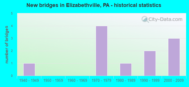
- New bridges - historical statistics
- 11940-1949
- 41970-1979
- 11980-1989
- 21990-1999
- 32000-2009

- Reconstructed bridges - Historical Statistics
- 11990-1999
- 12000-2009


- Bridge Condition - Deck
- 10.0%Very good
- 50.0%Good
- 20.0%Satisfactory
- 10.0%Fair
- 10.0%Poor

- Bridge Condition - Superstructure
- 9.1%Very good
- 27.3%Good
- 27.3%Satisfactory
- 27.3%Fair
- 9.1%Poor

- Bridge Condition - Substructure
- 36.4%Good
- 54.5%Satisfactory
- 9.1%Fair

- Bridge Condition - Channel
- 9.1%Good
- 18.2%Satisfactory
- 54.5%Fair
- 18.2%Poor
Find on map >> Show street view
Structure Number: 14306, Location: 3 MI.E. OF E-VILLE (Lat: 40.546347, Lng: -76.863256), Route carried "on" structure: US 209, Year Built: 1941, Year Reconstructed: 1998, Status: Open, Structure Length: 2.99m (9.81ft), Average Daily Traffic: 3,535 (year 2020), Truck Traffic: 7%, Average Future Daily Traffic: 4,846 (year 2032), Features Intersected: WICONISCO CREEK
Minimum Vertical Clearance: 30+ m (98+ ft), Kilometerpoint: 8.116, Lanes on structure: 2, Base Highway Network: Yes, Owner: State Highway Agency, Approaching Roadway Width: 11.9m (39.0ft), Material/Design: Concrete, Design/Construction: Arch - Deck, Number Of Spans In Main Unit: 1, Length of Maximum Span: 29.9m (98.1ft), Curb-To-Curb Width: 12.1m (39.7ft), Out-to-Out Width: 13.2m (43.3ft)
Condition: Superstructure: Fair, Substructure: Satisfactory, Channel: Poor, Operating Rating: 59.9 metric tons, Method Used To Determine Operating Rating: Field evaluation and documented engineering judgment, Inventory Rating: 35.4 metric tons, Method Used To Determine Inventory Rating: Field evaluation and documented engineering judgment, Structural Evaluation: Somewhat better than minimum adequacy, Deck Geometry: Somewhat better than minimum adequacy, Waterway Adequacy: Superior to present desirable criteria, Approach Roadway Alignment: Equal to present desirable criteria, Length Of Structure Improvement: 3.70m (12.14ft), Designated Inspection Frequency: Every 24 months, Underwater Inspection Frequency: Every 60 months, Inspection Date: August 2020, Underwater Inspection Date: September 2020, Bridge Improvement Cost: $12,000, Roadway Improvement Cost: $34,000, Total Project Cost: $157,000
Find on map >> Show street view
Structure Number: 14309, Location: LOYALTON (Lat: 40.568858, Lng: -76.764708), Route carried "on" structure: US 209, Year Built: 1991, Status: Open, Structure Length: 3.29m (10.79ft), Average Daily Traffic: 9,018 (year 2022), Truck Traffic: 3%, Average Future Daily Traffic: 12,116 (year 2032), Design Load: HS 25 or greater, Features Intersected: WICONISCO CREEK
Minimum Vertical Clearance: 30+ m (98+ ft), Kilometerpoint: 17.741, Lanes on structure: 2, Base Highway Network: Yes, Owner: State Highway Agency, Approaching Roadway Width: 10.1m (33.1ft), Skew: 1 degrees, Material/Design: Prestressed concrete, Design/Construction: Box Beam or Girders - Multiple, Number Of Spans In Main Unit: 2, Length of Maximum Span: 16.2m (53.1ft), Curb or Sidewalk Widths: Left: 0.2m (0.7ft), Right: 0.2m (0.7ft), Curb-To-Curb Width: 11.3m (37.1ft), Out-to-Out Width: 12.3m (40.4ft)
Condition: Deck: Satisfactory, Superstructure: Good, Substructure: Satisfactory, Channel: Satisfactory, Operating Rating: 96.2 metric tons, Method Used To Determine Operating Rating: Load Factor (LF), Inventory Rating: 43.5 metric tons, Method Used To Determine Inventory Rating: Load Factor (LF), Structural Evaluation: Equal to present minimum criteria, Deck Geometry: Meets minimum limits, Waterway Adequacy: Equal to present minimum criteria, Approach Roadway Alignment: Equal to present desirable criteria, Length Of Structure Improvement: 3.50m (11.48ft), Designated Inspection Frequency: Every 24 months, Inspection Date: August 2020, Bridge Improvement Cost: $85,000, Roadway Improvement Cost: $249,000, Total Project Cost: $1,143,000, Deck Structure Type: Concrete Cast-file-Place, Wearing Surface/Protective System: Wearing Surface: Monolithic Concrete, Deck Protection: Epoxy Coated Reinforcing
Find on map >> Show street view
Structure Number: 1432, Location: 1 MI N E-VILLE (Lat: 40.561150, Lng: -76.812567), Route carried "on" structure: State highway 225, Year Built: 1984, Status: Open, Structure Length: 3.78m (12.40ft), Average Daily Traffic: 3,395 (year 2022), Truck Traffic: 5%, Average Future Daily Traffic: 4,491 (year 2032), Design Load: HS 25 or greater, Features Intersected: WICONISCO CREEK
Minimum Vertical Clearance: 30+ m (98+ ft), Kilometerpoint: 28.151, Lanes on structure: 2, Base Highway Network: Yes, Owner: State Highway Agency, Approaching Roadway Width: 9.1m (29.9ft), Material/Design: Prestressed concrete, Design/Construction: Box Beam or Girders - Single/Spread, Number Of Spans In Main Unit: 3, Length of Maximum Span: 19.2m (63.0ft), Curb or Sidewalk Widths: Left: 0.2m (0.7ft), Right: 0.2m (0.7ft), Curb-To-Curb Width: 8.5m (27.9ft), Out-to-Out Width: 9.6m (31.5ft)
Condition: Deck: Satisfactory, Superstructure: Satisfactory, Substructure: Satisfactory, Channel: Fair, Operating Rating: 52.6 metric tons, Method Used To Determine Operating Rating: Load Factor (LF), Inventory Rating: 18.1 metric tons, Method Used To Determine Inventory Rating: Load Factor (LF), Structural Evaluation: Somewhat better than minimum adequacy, Deck Geometry: Meets minimum limits, Waterway Adequacy: Equal to present minimum criteria, Approach Roadway Alignment: Equal to present desirable criteria, Length Of Structure Improvement: 4.70m (15.42ft), Designated Inspection Frequency: Every 24 months, Inspection Date: August 2020, Deck Structure Type: Concrete Cast-file-Place, Wearing Surface/Protective System: Wearing Surface: Monolithic Concrete, Deck Protection: Epoxy Coated Reinforcing
Find on map >> Show street view
Structure Number: 14667, Location: 1.2NE ENDERS/ARMSTRONG CR (Lat: 40.507239, Lng: -76.830889), Route carried "on" structure: City street , Year Built: 1974, Status: Open, Structure Length: 1.10m (3.61ft), Average Daily Traffic: 75 (year 2021), Average Future Daily Traffic: 105 (year 2041), Design Load: HS 20, Features Intersected: ARMSTRONG CREEK, Facility Carried by Structure: DANNER ROAD,T-544
Minimum Vertical Clearance: 30+ m (98+ ft), Kilometerpoint: 0.000, Lanes on structure: 2, Owner: County Highway Agency, Approaching Roadway Width: 5.5m (18.0ft), Material/Design: Prestressed concrete, Design/Construction: Box Beam or Girders - Multiple, Number Of Spans In Main Unit: 1, Length of Maximum Span: 10.4m (34.1ft), Curb-To-Curb Width: 6.1m (20.0ft), Out-to-Out Width: 7.1m (23.3ft)
Condition: Deck: Fair, Superstructure: Satisfactory, Substructure: Satisfactory, Channel: Fair, Operating Rating: 53.5 metric tons, Method Used To Determine Operating Rating: Load Factor (LF), Inventory Rating: 26.3 metric tons, Method Used To Determine Inventory Rating: Load Factor (LF), Structural Evaluation: Equal to present minimum criteria, Deck Geometry: Somewhat better than minimum adequacy, Waterway Adequacy: Better than present minimum criteria, Approach Roadway Alignment: Somewhat better than minimum adequacy, Length Of Structure Improvement: 1.70m (5.58ft), Designated Inspection Frequency: Every 24 months, Inspection Date: August 2021, Deck Structure Type: Concrete Cast-file-Place, Wearing Surface/Protective System: Wearing Surface: Monolithic Concrete
Find on map >> Show street view
Structure Number: 14668, Location: 3.5S E-VILLE/ARMSTRONG CR (Lat: 40.515900, Lng: -76.819197), Route carried "on" structure: City street , Year Built: 1975, Status: Open, Structure Length: 0.70m (2.30ft), Average Daily Traffic: 75 (year 2021), Truck Traffic: 10%, Average Future Daily Traffic: 105 (year 2041), Features Intersected: ARMSTRONG CREEK, Facility Carried by Structure: BASTIAN RD T-546
Minimum Vertical Clearance: 30+ m (98+ ft), Kilometerpoint: 0.000, Lanes on structure: 2, Owner: Town or Township Highway Agency, Approaching Roadway Width: 5.5m (18.0ft), Material/Design: Prestressed concrete, Design/Construction: Box Beam or Girders - Multiple, Number Of Spans In Main Unit: 1, Length of Maximum Span: 6.7m (22.0ft), Curb-To-Curb Width: 7.6m (24.9ft), Out-to-Out Width: 8.6m (28.2ft)
Condition: Deck: Poor, Superstructure: Poor, Substructure: Fair, Channel: Poor, Operating Rating: 56.2 metric tons, Method Used To Determine Operating Rating: Load Factor (LF), Inventory Rating: 33.6 metric tons, Method Used To Determine Inventory Rating: Load Factor (LF), Structural Evaluation: Meets minimum limits, Deck Geometry: Equal to present minimum criteria, Waterway Adequacy: Equal to present minimum criteria, Approach Roadway Alignment: Equal to present desirable criteria, Length Of Structure Improvement: 1.30m (4.27ft), Designated Inspection Frequency: Every 24 months, Underwater Inspection Frequency: Every 24 months, Inspection Date: May 2021, Underwater Inspection Date: July 2020, Deck Structure Type: Other, Wearing Surface/Protective System: Wearing Surface: Bituminous
Find on map >> Show street view
Structure Number: 14708, Location: COOPER/2NW E-VLLE/WICONIS (Lat: 40.557231, Lng: -76.856853), Route carried "on" structure: City street , Year Built: 1973, Year Reconstructed: 2012, Status: Open, Structure Length: 2.53m (8.30ft), Average Daily Traffic: 100 (year 2021), Average Future Daily Traffic: 100 (year 2041), Design Load: HS 20, Features Intersected: WICONISCO CREEK, Facility Carried by Structure: FEIDT ROAD (T-462)
Minimum Vertical Clearance: 30+ m (98+ ft), Kilometerpoint: 0.000, Lanes on structure: 2, Owner: County Highway Agency, Approaching Roadway Width: 6.1m (20.0ft), Skew: 1 degrees, Material/Design: Prestressed concrete, Design/Construction: Box Beam or Girders - Multiple, Number Of Spans In Main Unit: 1, Length of Maximum Span: 25.3m (83.0ft), Curb or Sidewalk Widths: Left: 0.2m (0.7ft), Right: 0.2m (0.7ft), Curb-To-Curb Width: 8.8m (28.9ft), Out-to-Out Width: 9.9m (32.5ft)
Condition: Deck: Good, Superstructure: Fair, Substructure: Satisfactory, Channel: Fair, Operating Rating: 89.8 metric tons, Method Used To Determine Operating Rating: Load Factor (LF), Inventory Rating: 29.9 metric tons, Method Used To Determine Inventory Rating: Load Factor (LF), Structural Evaluation: Somewhat better than minimum adequacy, Deck Geometry: Better than present minimum criteria, Waterway Adequacy: Equal to present desirable criteria, Approach Roadway Alignment: Somewhat better than minimum adequacy, Length Of Structure Improvement: 3.30m (10.83ft), Designated Inspection Frequency: Every 24 months, Inspection Date: August 2021, Deck Structure Type: Concrete Cast-file-Place, Wearing Surface/Protective System: Wearing Surface: Monolithic Concrete
Find on map >> Show street view
Structure Number: 14709, Location: 2.8 W E-VILLE/WICONISCO (Lat: 40.544603, Lng: -76.868392), Route carried "on" structure: City street , Year Built: 1990, Status: Open, Structure Length: 2.35m (7.71ft), Average Daily Traffic: 150 (year 2021), Truck Traffic: 2%, Average Future Daily Traffic: 100 (year 2041), Design Load: HS 25 or greater, Features Intersected: WICONISCO CREEK, Facility Carried by Structure: MILL RD T-464
Minimum Vertical Clearance: 30+ m (98+ ft), Kilometerpoint: 0.000, Lanes on structure: 2, Owner: County Highway Agency, Approaching Roadway Width: 7.6m (24.9ft), Material/Design: Prestressed concrete, Design/Construction: Box Beam or Girders - Multiple, Number Of Spans In Main Unit: 1, Length of Maximum Span: 23.5m (77.1ft), Curb or Sidewalk Widths: Left: 0.2m (0.7ft), Right: 0.2m (0.7ft), Curb-To-Curb Width: 7.6m (24.9ft), Out-to-Out Width: 8.6m (28.2ft)
Condition: Deck: Good, Superstructure: Satisfactory, Substructure: Good, Channel: Fair, Operating Rating: 67.1 metric tons, Method Used To Determine Operating Rating: Load Factor (LF), Inventory Rating: 42.6 metric tons, Method Used To Determine Inventory Rating: Load Factor (LF), Structural Evaluation: Equal to present minimum criteria, Deck Geometry: Somewhat better than minimum adequacy, Waterway Adequacy: Equal to present desirable criteria, Approach Roadway Alignment: Equal to present desirable criteria, Length Of Structure Improvement: 3.10m (10.17ft), Designated Inspection Frequency: Every 24 months, Inspection Date: August 2021, Deck Structure Type: Concrete Cast-file-Place, Wearing Surface/Protective System: Wearing Surface: Monolithic Concrete, Deck Protection: Epoxy Coated Reinforcing
Find on map >> Show street view
Structure Number: 1471, Location: .5S LOYALTON/WICONISCO (Lat: 40.559933, Lng: -76.760558), Route carried "on" structure: City street , Year Built: 1973, Status: Open, Structure Length: 2.71m (8.89ft), Average Daily Traffic: 50 (year 2021), Average Future Daily Traffic: 70 (year 2041), Design Load: HS 20, Features Intersected: WICONISCO CREEK, Facility Carried by Structure: OAKDALE ST RD T585
Minimum Vertical Clearance: 30+ m (98+ ft), Kilometerpoint: 0.000, Lanes on structure: 2, Owner: County Highway Agency, Approaching Roadway Width: 5.8m (19.0ft), Skew: 2 degrees, Material/Design: Prestressed concrete, Design/Construction: Box Beam or Girders - Multiple, Number Of Spans In Main Unit: 1, Length of Maximum Span: 26.5m (86.9ft), Curb or Sidewalk Widths: Left: 0.2m (0.7ft), Right: 0.2m (0.7ft), Curb-To-Curb Width: 8.8m (28.9ft), Out-to-Out Width: 9.9m (32.5ft)
Condition: Deck: Good, Superstructure: Fair, Substructure: Satisfactory, Channel: Fair, Operating Rating: 62.6 metric tons, Method Used To Determine Operating Rating: Load and Resistance Factor (LRFR), Inventory Rating: 21.8 metric tons, Method Used To Determine Inventory Rating: Load and Resistance Factor (LRFR), Structural Evaluation: Somewhat better than minimum adequacy, Deck Geometry: Better than present minimum criteria, Waterway Adequacy: Better than present minimum criteria, Approach Roadway Alignment: Somewhat better than minimum adequacy, Length Of Structure Improvement: 3.50m (11.48ft), Designated Inspection Frequency: Every 24 months, Inspection Date: June 2021, Deck Structure Type: Concrete Cast-file-Place, Wearing Surface/Protective System: Wearing Surface: Monolithic Concrete
Find on map >> Show street view
Structure Number: 43128, Location: 4 MI.S. E-VILLE (Lat: 40.508817, Lng: -76.827119), Route carried "on" structure: State highway , Year Built: 2005, Status: Open, Structure Length: 1.16m (3.81ft), Average Daily Traffic: 71 (year 2019), Truck Traffic: 15%, Average Future Daily Traffic: 108 (year 2032), Design Load: HS 25 or greater, Features Intersected: ARMSTRONG CREEK, Facility Carried by Structure: SR 1004 MILLERS CH
Minimum Vertical Clearance: 30+ m (98+ ft), Kilometerpoint: 1.666, Lanes on structure: 2, Owner: State Highway Agency, Approaching Roadway Width: 7.9m (25.9ft), Material/Design: Prestressed concrete, Design/Construction: Box Beam or Girders - Single/Spread, Number Of Spans In Main Unit: 1, Length of Maximum Span: 11.0m (36.1ft), Curb or Sidewalk Widths: Left: 0.2m (0.7ft), Right: 0.2m (0.7ft), Curb-To-Curb Width: 7.9m (25.9ft), Out-to-Out Width: 9.0m (29.5ft)
Condition: Deck: Very good, Superstructure: Very good, Substructure: Good, Channel: Good, Operating Rating: 86.2 metric tons, Method Used To Determine Operating Rating: Load Factor (LF), Inventory Rating: 51.7 metric tons, Method Used To Determine Inventory Rating: Load Factor (LF), Structural Evaluation: Better than present minimum criteria, Deck Geometry: Equal to present minimum criteria, Waterway Adequacy: Better than present minimum criteria, Approach Roadway Alignment: Better than present minimum criteria, Designated Inspection Frequency: Every 24 months, Inspection Date: July 2020, Deck Structure Type: Concrete Cast-file-Place, Wearing Surface/Protective System: Wearing Surface: Monolithic Concrete, Deck Protection: Epoxy Coated Reinforcing
Find on map >> Show street view
Structure Number: 43516, Location: 1.5 MI N.W. E-VILLE (Lat: 40.568722, Lng: -76.826178), Route carried "on" structure: State highway , Year Built: 2005, Status: Open, Structure Length: 3.32m (10.89ft), Average Daily Traffic: 719 (year 2022), Truck Traffic: 1%, Average Future Daily Traffic: 252 (year 2032), Design Load: HS 20, Features Intersected: WICONISCO CREEK, Facility Carried by Structure: SR 1021
Minimum Vertical Clearance: 30+ m (98+ ft), Kilometerpoint: 2.665, Lanes on structure: 2, Owner: State Highway Agency, Approaching Roadway Width: 10.4m (34.1ft), Skew: 1 degrees, Material/Design: Prestressed concrete, Design/Construction: Box Beam or Girders - Single/Spread, Number Of Spans In Main Unit: 2, Length of Maximum Span: 16.2m (53.1ft), Curb-To-Curb Width: 10.4m (34.1ft), Out-to-Out Width: 11.4m (37.4ft)
Condition: Deck: Good, Superstructure: Good, Substructure: Good, Channel: Satisfactory, Operating Rating: 72.6 metric tons, Method Used To Determine Operating Rating: Load Factor (LF), Inventory Rating: 37.2 metric tons, Method Used To Determine Inventory Rating: Load Factor (LF), Structural Evaluation: Better than present minimum criteria, Deck Geometry: Equal to present minimum criteria, Waterway Adequacy: Superior to present desirable criteria, Approach Roadway Alignment: Equal to present desirable criteria, Designated Inspection Frequency: Every 24 months, Inspection Date: August 2020, Deck Structure Type: Concrete Cast-file-Place, Wearing Surface/Protective System: Wearing Surface: Monolithic Concrete, Deck Protection: Epoxy Coated Reinforcing
Find on map >> Show street view
Structure Number: 45499, Location: Washington Township (Lat: 40.554281, Lng: -76.836892), Route carried "on" structure: City street , Year Built: 2009, Status: Open, Structure Length: 2.50m (8.20ft), Average Daily Traffic: 50 (year 2021), Truck Traffic: 1%, Average Future Daily Traffic: 74 (year 2041), Design Load: HS 20, Features Intersected: Wiconisco Creek, Facility Carried by Structure: Mattis's Mil T-550
Minimum Vertical Clearance: 30+ m (98+ ft), Kilometerpoint: 0.000, Lanes on structure: 2, Toll: Toll bridge, Owner: County Highway Agency, Approaching Roadway Width: 7.3m (24.0ft), Skew: 3 degrees, Material/Design: Prestressed concrete, Design/Construction: Box Beam or Girders - Single/Spread, Number Of Spans In Main Unit: 1, Length of Maximum Span: 24.4m (80.1ft), Curb-To-Curb Width: 8.5m (27.9ft), Out-to-Out Width: 9.4m (30.8ft)
Condition: Deck: Good, Superstructure: Good, Substructure: Good, Channel: Fair, Operating Rating: 72.6 metric tons, Method Used To Determine Operating Rating: Load and Resistance Factor (LRFR), Inventory Rating: 41.7 metric tons, Method Used To Determine Inventory Rating: Load and Resistance Factor (LRFR), Structural Evaluation: Better than present minimum criteria, Deck Geometry: Better than present minimum criteria, Waterway Adequacy: Equal to present desirable criteria, Approach Roadway Alignment: Equal to present minimum criteria, Designated Inspection Frequency: Every 24 months, Inspection Date: July 2021, Deck Structure Type: Concrete Cast-file-Place, Wearing Surface/Protective System: Wearing Surface: Monolithic Concrete, Deck Protection: Epoxy Coated Reinforcing