Bridge Statistics for Elk Grove Village, Illinois (IL)
Condition, Traffic, Stress, Structural Evaluation, Project Costs
- National Bridge Inventory (NBI) Statistics
- 14Number of bridges
- 72ft / 21.7mTotal length
- $1,470,000Total costs
- 569,625Total average daily traffic
- 49,828Total average daily truck traffic
- National Bridge Inventory (NBI) Registered Bridges for Elk Grove Village
- No street view available for this location
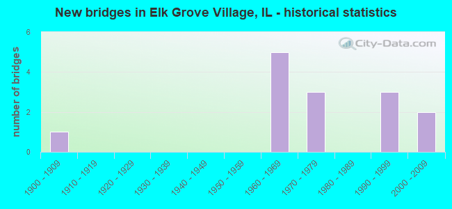
- New bridges - historical statistics
- 11900-1909
- 51960-1969
- 31970-1979
- 31990-1999
- 22000-2009

- Reconstructed bridges - Historical Statistics
- 11980-1989
- 11990-1999
- 12000-2009


- Bridge Condition - Deck
- 20.0%Good
- 40.0%Satisfactory
- 40.0%Fair

- Bridge Condition - Superstructure
- 40.0%Good
- 40.0%Satisfactory
- 20.0%Fair

- Bridge Condition - Substructure
- 60.0%Good
- 40.0%Satisfactory

- Bridge Condition - Channel
- 28.6%Very good
- 42.9%Good
- 14.3%Satisfactory
- 14.3%Fair

- Bridge Condition - Culverts
- 25.0%Good
- 75.0%Poor
Find on map >> Show street view
Structure Number: 160504, Location: 1 M E I-290,IL53 (Lat: 42.031472, Lng: -88.011456), Route carried "on" structure: State highway 72, Year Built: 1900, Year Reconstructed: 2008, Status: Open, Structure Length: 1.34m (4.40ft), Average Daily Traffic: 26,400 (year 2021), Truck Traffic: 6%, Average Future Daily Traffic: 35,123 (year 2032), Design Load: HS 20, Features Intersected: SALT CREEK
Minimum Vertical Clearance: 30+ m (98+ ft), Kilometerpoint: 158.661, Lanes on structure: 4, Base Highway Network: Yes, Owner: State Highway Agency, Approaching Roadway Width: 16.5m (54.1ft), Skew: 30 degrees, Material/Design: Prestressed concrete, Design/Construction: Box Beam or Girders - Multiple, Number Of Spans In Main Unit: 2, Length of Maximum Span: 6.7m (22.0ft), Curb-To-Curb Width: 17.4m (57.1ft), Out-to-Out Width: 22.6m (74.1ft)
Condition: Deck: Satisfactory, Superstructure: Satisfactory, Substructure: Satisfactory, Channel: Good, Operating Rating: 64.8 metric tons, Method Used To Determine Operating Rating: Load Factor (LF) rating reported by rating factor (RF) method using MS18 loading, Inventory Rating: 38.9 metric tons, Method Used To Determine Inventory Rating: Load Factor (LF) rating reported by rating factor (RF) method using MS18 loading, Structural Evaluation: Equal to present minimum criteria, Deck Geometry: Somewhat better than minimum adequacy, Waterway Adequacy: Equal to present desirable criteria, Approach Roadway Alignment: Equal to present desirable criteria, Length Of Structure Improvement: 1.34m (4.40ft), Designated Inspection Frequency: Every 24 months, Underwater Inspection Frequency: Every 60 months, Inspection Date: April 2021, Underwater Inspection Date: April 2021, Bridge Improvement Cost: $234,000, Roadway Improvement Cost: $23,000, Total Project Cost: $351,000, Deck Structure Type: Concrete Cast-file-Place, Wearing Surface/Protective System: Wearing Surface: Integral Concrete, Deck Protection: Epoxy Coated Reinforcing
Find on map >> Show street view
Structure Number: 16096, Location: 3.1 M S IL 72 (Lat: 42.003314, Lng: -88.028792), Route carried "on" structure: State highway 53, Year Built: 1968, Year Reconstructed: 1990, Status: Open, Structure Length: 8.63m (28.31ft), Average Daily Traffic: 26,700 (year 2021), Truck Traffic: 2%, Average Future Daily Traffic: 28,016 (year 2032), Design Load: HS 20, Features Intersected: I-290
Minimum Vertical Clearance: 30+ m (98+ ft), Kilometerpoint: 105.377, Lanes on structure: 5, Lanes under structure: 8, Base Highway Network: Yes, Owner: State Highway Agency, Approaching Roadway Width: 21.3m (69.9ft), Skew: 31 degrees, Material/Design: Steel continuous, Design/Construction: Stringer/Multi-beam, Number Of Spans In Main Unit: 2, Number Of Approach Spans: 2, Length of Maximum Span: 32.0m (105.0ft), Curb or Sidewalk Widths: Left: 1.5m (4.9ft), Right: 0.0m, Curb-To-Curb Width: 20.1m (65.9ft), Out-to-Out Width: 23.5m (77.1ft)
Condition: Deck: Fair, Superstructure: Satisfactory, Substructure: Satisfactory, Operating Rating: 42.1 metric tons, Method Used To Determine Operating Rating: Load Factor (LF) rating reported by rating factor (RF) method using MS18 loading, Inventory Rating: 25.3 metric tons, Method Used To Determine Inventory Rating: Load Factor (LF) rating reported by rating factor (RF) method using MS18 loading, Structural Evaluation: Equal to present minimum criteria, Deck Geometry: Somewhat better than minimum adequacy, Underclear: Somewhat better than minimum adequacy, Approach Roadway Alignment: Equal to present desirable criteria, Designated Inspection Frequency: Every 24 months, Other Special Inspection Frequency: Every 72 months, Inspection Date: April 2021, Other Special Inspection Date: April 2019, Deck Structure Type: Concrete Cast-file-Place, Wearing Surface/Protective System: Wearing Surface: Other
Find on map >> Show street view
Structure Number: 160996, Location: 0.2 M N BIESTERFIELD (Lat: 42.005036, Lng: -88.027408), Route carried "on" structure: Interstate 290, Year Built: 1970, Status: Open, Structure Length: 0.79m (2.59ft), Average Daily Traffic: 149,800 (year 2021), Truck Traffic: 10%, Average Future Daily Traffic: 212,077 (year 2032), Design Load: HS 20, Features Intersected: DRAIN DTCH
Minimum Vertical Clearance: 30+ m (98+ ft), Kilometerpoint: 5.745, Lanes on structure: 10, Base Highway Network: Yes, Owner: State Highway Agency, Approaching Roadway Width: 48.8m (160.1ft), Skew: 11 degrees, Material/Design: Concrete continuous, Design/Construction: Culvert, Number Of Spans In Main Unit: 2, Length of Maximum Span: 3.0m (9.8ft)
Condition: Channel: Satisfactory, Culverts: Good, Operating Rating: 54.4 metric tons, Method Used To Determine Operating Rating: Load Factor (LF) rating reported by rating factor (RF) method using MS18 loading, Inventory Rating: 32.7 metric tons, Method Used To Determine Inventory Rating: Load Factor (LF) rating reported by rating factor (RF) method using MS18 loading, Structural Evaluation: Better than present minimum criteria, Waterway Adequacy: Better than present minimum criteria, Approach Roadway Alignment: Equal to present desirable criteria, Designated Inspection Frequency: Every 24 months, Inspection Date: March 2021
Find on map >> Show street view
Structure Number: 162595, Location: 0.79 M N OF DEVON AV (Lat: 42.002553, Lng: -88.023619), Route carried "on" structure: Other road , Year Built: 1990, Status: Open, Structure Length: 3.11m (10.20ft), Average Daily Traffic: 5,200 (year 2021), Average Future Daily Traffic: 13,390 (year 2032), Design Load: HS 20, Features Intersected: I-290 MAINT DRIVE, Facility Carried by Structure: I-290 NB RAMPS@BFD
Minimum Vertical Clearance: 30+ m (98+ ft), Kilometerpoint: 0.547, Lanes on structure: 1, Lanes under structure: 2, Base Highway Network: Yes (Inventory Route: 10290040, Subroute: 20), Owner: State Highway Agency, Approaching Roadway Width: 17.7m (58.1ft), Skew: 31 degrees, Material/Design: Concrete continuous, Design/Construction: Slab, Number Of Spans In Main Unit: 3, Length of Maximum Span: 11.3m (37.1ft), Curb-To-Curb Width: 15.8m (51.8ft), Out-to-Out Width: 21.7m (71.2ft)
Condition: Deck: Fair, Superstructure: Fair, Substructure: Good, Operating Rating: 66.7 metric tons, Method Used To Determine Operating Rating: Load Factor (LF) rating reported by rating factor (RF) method using MS18 loading, Inventory Rating: 39.5 metric tons, Method Used To Determine Inventory Rating: Load Factor (LF) rating reported by rating factor (RF) method using MS18 loading, Structural Evaluation: Somewhat better than minimum adequacy, Deck Geometry: Superior to present desirable criteria, Underclear: Superior to present desirable criteria, Approach Roadway Alignment: Equal to present desirable criteria, Designated Inspection Frequency: Every 24 months, Inspection Date: April 2021, Deck Structure Type: Concrete Cast-file-Place, Wearing Surface/Protective System: Deck Protection: Epoxy Coated Reinforcing
Find on map >> Show street view
Structure Number: 163014, Location: 1.6 M S ILL 72 P5 (Lat: 42.012222, Lng: -88.001036), Route carried "on" structure: Other road , Year Built: 1971, Status: Open, Structure Length: 1.89m (6.20ft), Average Daily Traffic: 20,300 (year 2018), Truck Traffic: 3%, Average Future Daily Traffic: 29,664 (year 2032), Design Load: HS 20, Features Intersected: SALT CREEK, Facility Carried by Structure: ARLINGTON HEIGHTS
Minimum Vertical Clearance: 30+ m (98+ ft), Kilometerpoint: 16.479, Lanes on structure: 4, Base Highway Network: Yes, Owner: County Highway Agency, Approaching Roadway Width: 17.1m (56.1ft), Skew: 30 degrees, Material/Design: Steel, Design/Construction: Stringer/Multi-beam, Number Of Spans In Main Unit: 1, Length of Maximum Span: 17.5m (57.4ft), Curb or Sidewalk Widths: Left: 1.5m (4.9ft), Right: 1.5m (4.9ft), Curb-To-Curb Width: 17.2m (56.4ft), Out-to-Out Width: 22.6m (74.1ft)
Condition: Deck: Satisfactory, Superstructure: Good, Substructure: Good, Channel: Good, Operating Rating: 54.8 metric tons, Method Used To Determine Operating Rating: Load Factor (LF) rating reported by rating factor (RF) method using MS18 loading, Inventory Rating: 32.7 metric tons, Method Used To Determine Inventory Rating: Load Factor (LF) rating reported by rating factor (RF) method using MS18 loading, Structural Evaluation: Better than present minimum criteria, Deck Geometry: Somewhat better than minimum adequacy, Waterway Adequacy: Better than present minimum criteria, Approach Roadway Alignment: Equal to present minimum criteria, Designated Inspection Frequency: Every 24 months, Inspection Date: July 2021, Deck Structure Type: Concrete Cast-file-Place, Wearing Surface/Protective System: Wearing Surface: Latex Concrete
Find on map >> Show street view
Structure Number: 16692, Location: 0.5 M E ARL HTS P5 (Lat: 42.005583, Lng: -87.995111), Route carried "on" structure: Other road , Year Built: 1961, Year Reconstructed: 1991, Status: Open, Structure Length: 3.58m (11.75ft), Average Daily Traffic: 6,100 (year 2018), Truck Traffic: 5%, Average Future Daily Traffic: 10,197 (year 2032), Design Load: HS 20, Features Intersected: SALT CR, Facility Carried by Structure: JFK BLVD
Minimum Vertical Clearance: 30+ m (98+ ft), Kilometerpoint: 0.805, Lanes on structure: 4, Owner: City or Municipal Highway Agency, Approaching Roadway Width: 15.2m (49.9ft), Skew: 1 degrees, Material/Design: Steel continuous, Design/Construction: Stringer/Multi-beam, Number Of Spans In Main Unit: 2, Length of Maximum Span: 17.4m (57.1ft), Curb or Sidewalk Widths: Left: 2.4m (7.9ft), Right: 2.4m (7.9ft), Curb-To-Curb Width: 15.2m (49.9ft), Out-to-Out Width: 18.9m (62.0ft)
Condition: Deck: Good, Superstructure: Good, Substructure: Good, Channel: Good, Operating Rating: 49.2 metric tons, Method Used To Determine Operating Rating: Load Factor (LF) rating reported by rating factor (RF) method using MS18 loading, Inventory Rating: 29.5 metric tons, Method Used To Determine Inventory Rating: Load Factor (LF) rating reported by rating factor (RF) method using MS18 loading, Structural Evaluation: Better than present minimum criteria, Deck Geometry: High priority of corrective action, Waterway Adequacy: Equal to present desirable criteria, Approach Roadway Alignment: Equal to present desirable criteria, Length Of Structure Improvement: 4.51m (14.80ft), Designated Inspection Frequency: Every 24 months, Inspection Date: June 2021, Bridge Improvement Cost: $746,000, Roadway Improvement Cost: $75,000, Total Project Cost: $1,119,000, Deck Structure Type: Concrete Cast-file-Place
Find on map >> Show street view
Structure Number: 167854, Location: 0.3 M N BISTERFD P5 (Lat: 42.008017, Lng: -88.012619), Route carried "on" structure: City street , Year Built: 1969, Status: Open, Structure Length: 0.79m (2.59ft), Average Daily Traffic: 1,250 (year 2018), Truck Traffic: 5%, Average Future Daily Traffic: 524 (year 2032), Features Intersected: LAKE COSMAN, Facility Carried by Structure: MS2080 WELLINGTON
Minimum Vertical Clearance: 30+ m (98+ ft), Kilometerpoint: 0.080, Lanes on structure: 2, Owner: City or Municipal Highway Agency, Approaching Roadway Width: 10.4m (34.1ft), Material/Design: Steel, Design/Construction: Culvert, Number Of Spans In Main Unit: 1, Length of Maximum Span: 7.9m (25.9ft), Curb or Sidewalk Widths: Left: 1.2m (3.9ft), Right: 1.2m (3.9ft), Curb-To-Curb Width: 10.4m (34.1ft), Out-to-Out Width: 11.0m (36.1ft)
Condition: Channel: Very good, Culverts: Poor, Operating Rating: 32.4 metric tons, Method Used To Determine Operating Rating: Field evaluation and documented engineering judgment, Inventory Rating: 17.5 metric tons, Method Used To Determine Inventory Rating: Field evaluation and documented engineering judgment, Structural Evaluation: Meets minimum limits, Deck Geometry: Equal to present minimum criteria, Waterway Adequacy: Superior to present desirable criteria, Approach Roadway Alignment: Equal to present desirable criteria, Designated Inspection Frequency: Every 24 months, Inspection Date: May 2020, Wearing Surface/Protective System: Wearing Surface: Bituminous
Find on map >> Show street view
Structure Number: 167855, Location: 1.2 M N DEVON P5 (Lat: 42.008861, Lng: -88.013681), Route carried "on" structure: City street , Year Built: 1969, Status: Open, Structure Length: 0.79m (2.59ft), Average Daily Traffic: 675 (year 2018), Truck Traffic: 8%, Average Future Daily Traffic: 318 (year 2032), Features Intersected: LAKE COSMAN, Facility Carried by Structure: MS-2100 LEICESTER
Minimum Vertical Clearance: 30+ m (98+ ft), Kilometerpoint: 0.161, Lanes on structure: 2, Owner: City or Municipal Highway Agency, Approaching Roadway Width: 10.4m (34.1ft), Material/Design: Steel, Design/Construction: Culvert, Number Of Spans In Main Unit: 1, Length of Maximum Span: 7.9m (25.9ft), Curb or Sidewalk Widths: Left: 1.2m (3.9ft), Right: 1.2m (3.9ft), Curb-To-Curb Width: 10.4m (34.1ft), Out-to-Out Width: 11.0m (36.1ft)
Condition: Channel: Very good, Culverts: Poor, Operating Rating: 32.4 metric tons, Method Used To Determine Operating Rating: Field evaluation and documented engineering judgment, Inventory Rating: 17.5 metric tons, Method Used To Determine Inventory Rating: Field evaluation and documented engineering judgment, Structural Evaluation: Meets minimum limits, Deck Geometry: Equal to present minimum criteria, Waterway Adequacy: Superior to present desirable criteria, Approach Roadway Alignment: Equal to present desirable criteria, Designated Inspection Frequency: Every 24 months, Inspection Date: May 2020, Wearing Surface/Protective System: Wearing Surface: Bituminous
Find on map >> Show street view
Structure Number: 22747, Location: 300 FT S DEVON AVE (Lat: 41.993106, Lng: -87.953592), Route carried "on" structure: City street , Year Built: 1970, Status: Open, Structure Length: 0.76m (2.49ft), Average Daily Traffic: 175 (year 2020), Truck Traffic: 21%, Average Future Daily Traffic: 344 (year 2032), Design Load: H 20, Features Intersected: WILLOW CREEK, Facility Carried by Structure: BRICKVALE DRIVE
Minimum Vertical Clearance: 30+ m (98+ ft), Kilometerpoint: 0.016, Lanes on structure: 3, Owner: City or Municipal Highway Agency, Approaching Roadway Width: 11.0m (36.1ft), Skew: 3 degrees, Material/Design: Steel, Design/Construction: Culvert, Number Of Spans In Main Unit: 2, Length of Maximum Span: 7.6m (24.9ft), Curb or Sidewalk Widths: Left: 1.2m (3.9ft), Right: 1.2m (3.9ft), Curb-To-Curb Width: 11.0m (36.1ft), Out-to-Out Width: 12.2m (40.0ft)
Condition: Channel: Fair, Culverts: Poor, Operating Rating: 40.5 metric tons, Method Used To Determine Operating Rating: Field evaluation and documented engineering judgment, Inventory Rating: 24.3 metric tons, Method Used To Determine Inventory Rating: Field evaluation and documented engineering judgment, Structural Evaluation: Meets minimum limits, Deck Geometry: High priority of replacement, Waterway Adequacy: Equal to present minimum criteria, Approach Roadway Alignment: Equal to present desirable criteria, Designated Inspection Frequency: Every 24 months, Inspection Date: May 2020, Deck Structure Type: Concrete Cast-file-Place, Wearing Surface/Protective System: Wearing Surface: Bituminous
Find on map >> Show street view
Structure Number: 16096, Location: 3.1 M S IL 72 (Lat: 42.003364, Lng: -88.026869), Route carried "under" structure: Interstate 290, Year Built: 1968, Structure Length: 0. m, Average Daily Traffic: 149,800 (year 2021), Truck Traffic: 10%, Features Intersected: I-290, Facility Carried by Structure: IL 53 BIESTERFIEL
Minimum Vertical Clearance: 5.13m (16.83ft), Kilometerpoint: 6.067, Lanes on structure: 5, Lanes under structure: 8, Material/Design: Steel continuous, Design/Construction: Stringer/Multi-beam, Length of Maximum Span: 32.0m (105.0ft)
Find on map >> Show street view
Structure Number: 162595, Location: 0.79 M N OF DEVON AV (Lat: 42.002561, Lng: -88.023694), Route carried "under" structure: City street , Year Built: 1990, Structure Length: 0. m, Average Daily Traffic: 325 (year 2018), Truck Traffic: 37%, Features Intersected: I-290 MAINT DRIVE, Facility Carried by Structure: I-290 NB RAMPS@BFD
Minimum Vertical Clearance: 4.11m (13.48ft), Kilometerpoint: 0.032, Lanes on structure: 1, Lanes under structure: 2, Material/Design: Concrete continuous, Design/Construction: Slab, Length of Maximum Span: 11.3m (37.1ft)
Find on map >> Show street view
Structure Number: 16326, Location: 0.02M W OF ARL HTS R (Lat: 42.028511, Lng: -87.990442), Route carried "under" structure: State highway 72, Year Built: 1996, Structure Length: 0. m, Average Daily Traffic: 26,400 (year 2021), Truck Traffic: 6%, Features Intersected: IL 72, Facility Carried by Structure: PED/BIKE PATH
Minimum Vertical Clearance: 5.26m (17.26ft), Kilometerpoint: 160.431, Lanes under structure: 4, Length of Maximum Span: 38.4m (126.0ft)
Find on map >> Show street view
Structure Number: 166922, Location: .2M N OF BIESTERFIEL (Lat: 42.006214, Lng: -88.027769), Route carried "under" structure: Interstate 290, Year Built: 2001, Structure Length: 0. m, Average Daily Traffic: 149,800 (year 2021), Truck Traffic: 10%, Features Intersected: I-290, Facility Carried by Structure: BIKE PATH
Minimum Vertical Clearance: 30+ m (98+ ft), Kilometerpoint: 5.520, Lanes under structure: 8, Material/Design: Steel continuous, Length of Maximum Span: 0.0m
Find on map >> Show street view
Structure Number: 166922, Location: .2M N OF BIESTERFIEL (Lat: 42.006211, Lng: -88.027978), Route carried "under" structure: Other road , Year Built: 2001, Structure Length: 0. m, Average Daily Traffic: 6,700 (year 2021), Features Intersected: I-290, Facility Carried by Structure: BIKE PATH
Minimum Vertical Clearance: 30+ m (98+ ft), Kilometerpoint: 0.048, Lanes under structure: 2, Material/Design: Steel continuous, Length of Maximum Span: 0.0m