Bridge Statistics for Ellensburg, Washington (WA)
Condition, Traffic, Stress, Structural Evaluation, Project Costs
- National Bridge Inventory (NBI) Statistics
- 83Number of bridges
- 850ft / 259mTotal length
- $113,610,000Total costs
- 489,077Total average daily traffic
- 91,770Total average daily truck traffic
- National Bridge Inventory (NBI) Registered Bridges for Ellensburg
- No street view available for this location
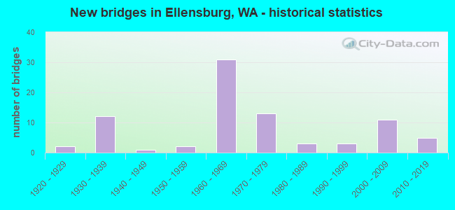
- New bridges - historical statistics
- 21920-1929
- 121930-1939
- 11940-1949
- 21950-1959
- 311960-1969
- 131970-1979
- 31980-1989
- 31990-1999
- 112000-2009
- 52010-2019
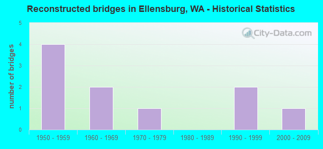
- Reconstructed bridges - Historical Statistics
- 41950-1959
- 21960-1969
- 11970-1979
- 01980-1989
- 21990-1999
- 12000-2009
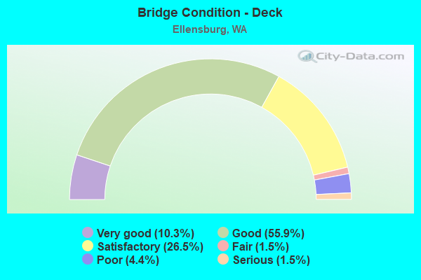
- Bridge Condition - Deck
- 10.3%Very good
- 55.9%Good
- 26.5%Satisfactory
- 1.5%Fair
- 4.4%Poor
- 1.5%Serious
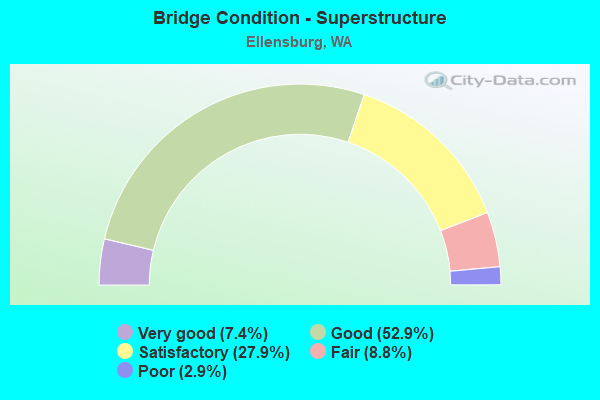
- Bridge Condition - Superstructure
- 7.4%Very good
- 52.9%Good
- 27.9%Satisfactory
- 8.8%Fair
- 2.9%Poor
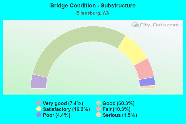
- Bridge Condition - Substructure
- 7.4%Very good
- 60.3%Good
- 16.2%Satisfactory
- 10.3%Fair
- 4.4%Poor
- 1.5%Serious
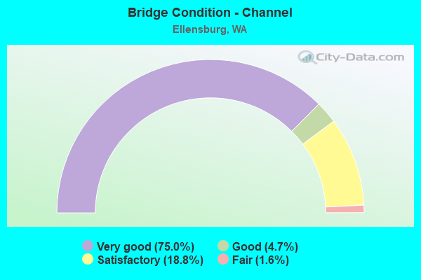
- Bridge Condition - Channel
- 75.0%Very good
- 4.7%Good
- 18.8%Satisfactory
- 1.6%Fair
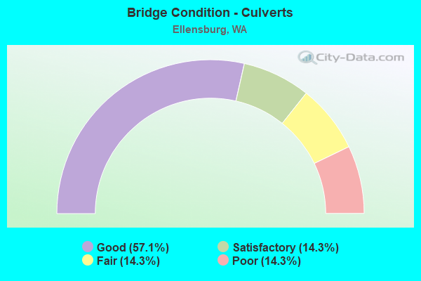
- Bridge Condition - Culverts
- 57.1%Good
- 14.3%Satisfactory
- 14.3%Fair
- 14.3%Poor
Find on map >> Show street view
Structure Number: 1367A, Location: 16.0 E JCT SR 970 (Lat: 47.038331, Lng: -120.616333), Route carried "on" structure: State highway 10, Year Built: 1930, Status: Open, Structure Length: 1.89m (6.20ft), Average Daily Traffic: 1,584 (year 2019), Truck Traffic: 8%, Average Future Daily Traffic: 2,059 (year 2039), Design Load: H 15, Features Intersected: HAND DRAIN DITCH
Minimum Vertical Clearance: 30+ m (98+ ft), Kilometerpoint: 167.501, Lanes on structure: 2, Owner: State Highway Agency, Approaching Roadway Width: 8.5m (27.9ft), Material/Design: Concrete continuous, Design/Construction: Slab, Number Of Spans In Main Unit: 3, Length of Maximum Span: 6.1m (20.0ft), Curb-To-Curb Width: 8.2m (26.9ft), Out-to-Out Width: 9.2m (30.2ft)
Condition: Deck: Good, Superstructure: Satisfactory, Substructure: Fair, Channel: Very good, Operating Rating: 24.3 metric tons, Method Used To Determine Operating Rating: Load and Resistance Factor Rating (LRFR) rating reported by rating factor(RF) method using HL-93 loadings, Inventory Rating: 18.8 metric tons, Method Used To Determine Inventory Rating: Load and Resistance Factor Rating (LRFR) rating reported by rating factor(RF) method using HL-93 loadings, Structural Evaluation: Somewhat better than minimum adequacy, Deck Geometry: Meets minimum limits, Waterway Adequacy: Equal to present desirable criteria, Approach Roadway Alignment: Equal to present desirable criteria, Length Of Structure Improvement: 1.89m (6.20ft), Designated Inspection Frequency: Every 24 months, Inspection Date: June 2021, Bridge Improvement Cost: $372,000, Roadway Improvement Cost: $74,000, Total Project Cost: $744,000 ( Estimate for 2014), Deck Structure Type: Concrete Cast-file-Place, Wearing Surface/Protective System: Wearing Surface: Bituminous
Find on map >> Show street view
Structure Number: 1367B, Location: 16.2 E JCT SR 970 (Lat: 47.036472, Lng: -120.613694), Route carried "on" structure: State highway 10, Year Built: 1930, Status: Open, Structure Length: 3.32m (10.89ft), Average Daily Traffic: 1,584 (year 2019), Truck Traffic: 8%, Average Future Daily Traffic: 2,059 (year 2039), Design Load: H 15, Features Intersected: DRY CR
Minimum Vertical Clearance: 30+ m (98+ ft), Kilometerpoint: 167.774, Lanes on structure: 2, Owner: State Highway Agency, Approaching Roadway Width: 9.8m (32.2ft), Skew: 2 degrees, Material/Design: Concrete continuous, Design/Construction: Slab, Number Of Spans In Main Unit: 6, Length of Maximum Span: 4.9m (16.1ft), Curb-To-Curb Width: 8.2m (26.9ft), Out-to-Out Width: 9.2m (30.2ft)
Condition: Deck: Good, Superstructure: Satisfactory, Substructure: Satisfactory, Channel: Satisfactory, Operating Rating: 29.5 metric tons, Method Used To Determine Operating Rating: Load and Resistance Factor Rating (LRFR) rating reported by rating factor(RF) method using HL-93 loadings, Inventory Rating: 23.0 metric tons, Method Used To Determine Inventory Rating: Load and Resistance Factor Rating (LRFR) rating reported by rating factor(RF) method using HL-93 loadings, Structural Evaluation: Equal to present minimum criteria, Deck Geometry: Meets minimum limits, Waterway Adequacy: Equal to present minimum criteria, Approach Roadway Alignment: Equal to present desirable criteria, Length Of Structure Improvement: 3.32m (10.89ft), Designated Inspection Frequency: Every 24 months, Inspection Date: June 2021, Bridge Improvement Cost: $741,000, Roadway Improvement Cost: $148,000, Total Project Cost: $1,482,000 ( Estimate for 2014), Deck Structure Type: Concrete Cast-file-Place, Wearing Surface/Protective System: Wearing Surface: Bituminous
Find on map >> Show street view
Structure Number: 1367C, Location: 1.8 N JCT I-90 (Lat: 47.025414, Lng: -120.597514), Route carried "on" structure: US 97, Year Built: 1930, Status: Open, Structure Length: 1.01m (3.31ft), Average Daily Traffic: 4,203 (year 2019), Truck Traffic: 17%, Average Future Daily Traffic: 5,463 (year 2039), Design Load: H 15, Features Intersected: DRAIN CANAL
Minimum Vertical Clearance: 30+ m (98+ ft), Kilometerpoint: 218.420, Lanes on structure: 2, Base Highway Network: Yes, Owner: State Highway Agency, Approaching Roadway Width: 9.4m (30.8ft), Material/Design: Concrete continuous, Design/Construction: Slab, Number Of Spans In Main Unit: 2, Length of Maximum Span: 4.3m (14.1ft), Curb-To-Curb Width: 8.2m (26.9ft), Out-to-Out Width: 9.3m (30.5ft)
Condition: Deck: Good, Superstructure: Good, Substructure: Good, Channel: Very good, Operating Rating: 28.2 metric tons, Method Used To Determine Operating Rating: Load and Resistance Factor Rating (LRFR) rating reported by rating factor(RF) method using HL-93 loadings, Inventory Rating: 21.7 metric tons, Method Used To Determine Inventory Rating: Load and Resistance Factor Rating (LRFR) rating reported by rating factor(RF) method using HL-93 loadings, Structural Evaluation: Somewhat better than minimum adequacy, Deck Geometry: High priority of corrective action, Waterway Adequacy: Equal to present desirable criteria, Approach Roadway Alignment: Equal to present desirable criteria, Length Of Structure Improvement: 1.01m (3.31ft), Designated Inspection Frequency: Every 24 months, Inspection Date: Febuary 2021, Bridge Improvement Cost: $218,000, Roadway Improvement Cost: $44,000, Total Project Cost: $436,000 ( Estimate for 2014), Deck Structure Type: Concrete Cast-file-Place, Wearing Surface/Protective System: Wearing Surface: Bituminous
Find on map >> Show street view
Structure Number: 1584A, Location: 19.3 N YAKIMA CO (Lat: 46.917086, Lng: -120.508025), Route carried "on" structure: State highway 821, Year Built: 1932, Status: Open, Structure Length: 4.91m (16.11ft), Average Daily Traffic: 1,432 (year 2019), Truck Traffic: 7%, Average Future Daily Traffic: 1,861 (year 2039), Design Load: H 15, Features Intersected: LOWER WILSON CREEK
Minimum Vertical Clearance: 30+ m (98+ ft), Kilometerpoint: 38.640, Lanes on structure: 2, Owner: State Highway Agency, Approaching Roadway Width: 10.4m (34.1ft), Material/Design: Concrete continuous, Design/Construction: Tee Beam, Number Of Spans In Main Unit: 4, Length of Maximum Span: 12.2m (40.0ft), Curb or Sidewalk Widths: Left: 1.1m (3.6ft), Right: 0.2m (0.7ft), Curb-To-Curb Width: 7.3m (24.0ft), Out-to-Out Width: 9.4m (30.8ft)
Condition: Deck: Satisfactory, Superstructure: Satisfactory, Substructure: Satisfactory, Channel: Satisfactory, Operating Rating: 38.2 metric tons, Method Used To Determine Operating Rating: Load and Resistance Factor Rating (LRFR) rating reported by rating factor(RF) method using HL-93 loadings, Inventory Rating: 29.5 metric tons, Method Used To Determine Inventory Rating: Load and Resistance Factor Rating (LRFR) rating reported by rating factor(RF) method using HL-93 loadings, Structural Evaluation: Equal to present minimum criteria, Deck Geometry: Meets minimum limits, Waterway Adequacy: Equal to present desirable criteria, Approach Roadway Alignment: Equal to present desirable criteria, Length Of Structure Improvement: 4.91m (16.11ft), Designated Inspection Frequency: Every 24 months, Inspection Date: September 2021, Bridge Improvement Cost: $1,159,000, Roadway Improvement Cost: $232,000, Total Project Cost: $2,318,000 ( Estimate for 2014), Deck Structure Type: Concrete Cast-file-Place, Wearing Surface/Protective System: Wearing Surface: Bituminous, Membrane: Preformed Fabric
Find on map >> Show street view
Structure Number: 2193A, Location: 2.5 N JCT I-90 (Lat: 47.032600, Lng: -120.607975), Route carried "on" structure: US 97, Year Built: 1936, Status: Open, Structure Length: 1.52m (4.99ft), Average Daily Traffic: 4,203 (year 2019), Truck Traffic: 17%, Average Future Daily Traffic: 5,463 (year 2039), Design Load: H 15, Features Intersected: SLOUGH BR
Minimum Vertical Clearance: 30+ m (98+ ft), Kilometerpoint: 219.547, Lanes on structure: 2, Base Highway Network: Yes, Owner: State Highway Agency, Approaching Roadway Width: 9.8m (32.2ft), Material/Design: Concrete continuous, Design/Construction: Slab, Number Of Spans In Main Unit: 2, Length of Maximum Span: 6.7m (22.0ft), Curb-To-Curb Width: 8.2m (26.9ft), Out-to-Out Width: 9.2m (30.2ft)
Condition: Deck: Good, Superstructure: Satisfactory, Substructure: Good, Channel: Very good, Operating Rating: 34.0 metric tons, Method Used To Determine Operating Rating: Load and Resistance Factor Rating (LRFR) rating reported by rating factor(RF) method using HL-93 loadings, Inventory Rating: 26.2 metric tons, Method Used To Determine Inventory Rating: Load and Resistance Factor Rating (LRFR) rating reported by rating factor(RF) method using HL-93 loadings, Structural Evaluation: Equal to present minimum criteria, Deck Geometry: High priority of corrective action, Waterway Adequacy: Equal to present desirable criteria, Approach Roadway Alignment: Equal to present desirable criteria, Length Of Structure Improvement: 1.52m (4.99ft), Designated Inspection Frequency: Every 24 months, Inspection Date: June 2021, Bridge Improvement Cost: $340,000, Roadway Improvement Cost: $68,000, Total Project Cost: $680,000 ( Estimate for 2014), Deck Structure Type: Concrete Cast-file-Place, Wearing Surface/Protective System: Wearing Surface: Bituminous
Find on map >> Show street view
Structure Number: 3317A, Location: 20.3 N YAKIMA CO (Lat: 46.926194, Lng: -120.501556), Route carried "on" structure: State highway 821, Year Built: 1947, Status: Posted for load, Structure Length: 2.68m (8.79ft), Average Daily Traffic: 1,148 (year 2019), Truck Traffic: 17%, Average Future Daily Traffic: 1,492 (year 2039), Design Load: H 15, Features Intersected: WILSON CR
Minimum Vertical Clearance: 30+ m (98+ ft), Kilometerpoint: 40.298, Lanes on structure: 2, Owner: State Highway Agency, Approaching Roadway Width: 7.9m (25.9ft), Skew: 3 degrees, Material/Design: Concrete continuous, Design/Construction: Tee Beam, Number Of Spans In Main Unit: 3, Length of Maximum Span: 17.1m (56.1ft), Curb-To-Curb Width: 7.3m (24.0ft), Out-to-Out Width: 8.5m (27.9ft)
Condition: Deck: Good, Superstructure: Good, Substructure: Good, Channel: Satisfactory, Operating Rating: 23.7 metric tons, Method Used To Determine Operating Rating: Load and Resistance Factor Rating (LRFR) rating reported by rating factor(RF) method using HL-93 loadings, Inventory Rating: 18.5 metric tons, Method Used To Determine Inventory Rating: Load and Resistance Factor Rating (LRFR) rating reported by rating factor(RF) method using HL-93 loadings, Structural Evaluation: Somewhat better than minimum adequacy, Deck Geometry: Meets minimum limits, Waterway Adequacy: Equal to present desirable criteria, Approach Roadway Alignment: Equal to present desirable criteria, Bridge Posting: Required (Relationship of Operating Rating to Maximum Legal Load: 30.0 - 39.9% below), Length Of Structure Improvement: 2.68m (8.79ft), Designated Inspection Frequency: Every 24 months, Inspection Date: September 2020, Bridge Improvement Cost: $493,000, Roadway Improvement Cost: $99,000, Total Project Cost: $986,000 ( Estimate for 2014), Deck Structure Type: Concrete Cast-file-Place, Wearing Surface/Protective System: Wearing Surface: Bituminous, Membrane: Preformed Fabric
Find on map >> Show street view
Structure Number: 7830B, Location: JCT I-90 (Lat: 47.005694, Lng: -120.591528), Route carried "on" structure: US 97, Year Built: 1966, Status: Open, Structure Length: 8.29m (27.20ft), Average Daily Traffic: 10,692 (year 2019), Truck Traffic: 23%, Average Future Daily Traffic: 13,899 (year 2039), Design Load: HS 20, Features Intersected: I-90, WEST ELLENSBURG
Minimum Vertical Clearance: 30+ m (98+ ft), Kilometerpoint: 215.491, Lanes on structure: 2, Lanes under structure: 5, Base Highway Network: Yes, Owner: State Highway Agency, Approaching Roadway Width: 11.6m (38.1ft), Skew: 3 degrees, Material/Design: Prestressed concrete, Design/Construction: Stringer/Multi-beam, Number Of Spans In Main Unit: 4, Length of Maximum Span: 27.4m (89.9ft), Curb or Sidewalk Widths: Left: 0.5m (1.6ft), Right: 0.5m (1.6ft), Curb-To-Curb Width: 8.5m (27.9ft), Out-to-Out Width: 10.1m (33.1ft)
Condition: Deck: Good, Superstructure: Good, Substructure: Good, Operating Rating: 23.3 metric tons, Method Used To Determine Operating Rating: Load and Resistance Factor Rating (LRFR) rating reported by rating factor(RF) method using HL-93 loadings, Inventory Rating: 17.8 metric tons, Method Used To Determine Inventory Rating: Load and Resistance Factor Rating (LRFR) rating reported by rating factor(RF) method using HL-93 loadings, Structural Evaluation: Meets minimum limits, Deck Geometry: Meets minimum limits, Underclear: Meets minimum limits, Approach Roadway Alignment: Equal to present desirable criteria, Length Of Structure Improvement: 8.29m (27.20ft), Designated Inspection Frequency: Every 24 months, Inspection Date: July 2021, Bridge Improvement Cost: $2,176,000, Roadway Improvement Cost: $435,000, Total Project Cost: $4,352,000 ( Estimate for 2014), Deck Structure Type: Concrete Cast-file-Place, Wearing Surface/Protective System: Wearing Surface: Latex Concrete
Find on map >> Show street view
Structure Number: 8036C, Location: 18.9 E JCT SR 970 (Lat: 47.020358, Lng: -120.610103), Route carried "on" structure: Interstate 90, Year Built: 1967, Status: Open, Structure Length: 11.89m (39.01ft), Average Daily Traffic: 15,451 (year 2019), Truck Traffic: 20%, Average Future Daily Traffic: 20,086 (year 2039), Design Load: HS 20+Mod, Features Intersected: DRY CREEK
Minimum Vertical Clearance: 30+ m (98+ ft), Kilometerpoint: 168.514, Lanes on structure: 2, Base Highway Network: Yes, Owner: State Highway Agency, Approaching Roadway Width: 11.6m (38.1ft), Material/Design: Concrete continuous, Design/Construction: Box Beam or Girders - Multiple, Number Of Spans In Main Unit: 5, Length of Maximum Span: 32.0m (105.0ft), Curb or Sidewalk Widths: Left: 0.5m (1.6ft), Right: 0.5m (1.6ft), Curb-To-Curb Width: 9.1m (29.9ft), Out-to-Out Width: 10.7m (35.1ft)
Condition: Deck: Fair, Superstructure: Good, Substructure: Good, Channel: Very good, Operating Rating: 49.6 metric tons, Method Used To Determine Operating Rating: Load and Resistance Factor Rating (LRFR) rating reported by rating factor(RF) method using HL-93 loadings, Inventory Rating: 38.2 metric tons, Method Used To Determine Inventory Rating: Load and Resistance Factor Rating (LRFR) rating reported by rating factor(RF) method using HL-93 loadings, Structural Evaluation: Better than present minimum criteria, Deck Geometry: Meets minimum limits, Waterway Adequacy: Equal to present desirable criteria, Approach Roadway Alignment: Equal to present desirable criteria, Length Of Structure Improvement: 11.89m (39.01ft), Designated Inspection Frequency: Every 24 months, Inspection Date: June 2020, Bridge Improvement Cost: $3,120,000, Roadway Improvement Cost: $624,000, Total Project Cost: $6,240,000 ( Estimate for 2014), Deck Structure Type: Concrete Cast-file-Place, Wearing Surface/Protective System: Wearing Surface: Latex Concrete
Find on map >> Show street view
Structure Number: 8036D, Location: 18.9 E JCT SR 970 (Lat: 47.020833, Lng: -120.610000), Route carried "on" structure: Interstate 90, Year Built: 1967, Status: Open, Structure Length: 11.89m (39.01ft), Average Daily Traffic: 15,451 (year 2019), Truck Traffic: 20%, Average Future Daily Traffic: 20,086 (year 2039), Design Load: HS 20+Mod, Features Intersected: DRY CREEK
Minimum Vertical Clearance: 30+ m (98+ ft), Kilometerpoint: 168.514, Lanes on structure: 2, Base Highway Network: Yes, Owner: State Highway Agency, Approaching Roadway Width: 11.6m (38.1ft), Material/Design: Concrete continuous, Design/Construction: Box Beam or Girders - Multiple, Number Of Spans In Main Unit: 5, Length of Maximum Span: 33.5m (109.9ft), Curb or Sidewalk Widths: Left: 0.5m (1.6ft), Right: 0.5m (1.6ft), Curb-To-Curb Width: 9.1m (29.9ft), Out-to-Out Width: 10.7m (35.1ft)
Condition: Deck: Satisfactory, Superstructure: Good, Substructure: Good, Channel: Very good, Operating Rating: 49.6 metric tons, Method Used To Determine Operating Rating: Load and Resistance Factor Rating (LRFR) rating reported by rating factor(RF) method using HL-93 loadings, Inventory Rating: 38.2 metric tons, Method Used To Determine Inventory Rating: Load and Resistance Factor Rating (LRFR) rating reported by rating factor(RF) method using HL-93 loadings, Structural Evaluation: Better than present minimum criteria, Deck Geometry: Meets minimum limits, Waterway Adequacy: Equal to present desirable criteria, Approach Roadway Alignment: Equal to present desirable criteria, Length Of Structure Improvement: 11.89m (39.01ft), Designated Inspection Frequency: Every 48 months, Inspection Date: June 2018, Bridge Improvement Cost: $3,120,000, Roadway Improvement Cost: $624,000, Total Project Cost: $6,240,000 ( Estimate for 2014), Deck Structure Type: Concrete Cast-file-Place, Wearing Surface/Protective System: Wearing Surface: Latex Concrete
Find on map >> Show street view
Structure Number: 8200A, Location: 1.4 E JCT US 97 (Lat: 46.990694, Lng: -120.572472), Route carried "on" structure: Interstate 90, Year Built: 1967, Status: Open, Structure Length: 3.66m (12.01ft), Average Daily Traffic: 14,690 (year 2019), Truck Traffic: 20%, Average Future Daily Traffic: 19,097 (year 2039), Design Load: HS 20+Mod, Features Intersected: REESER CREEK
Minimum Vertical Clearance: 30+ m (98+ ft), Kilometerpoint: 172.892, Lanes on structure: 2, Base Highway Network: Yes, Owner: State Highway Agency, Approaching Roadway Width: 11.6m (38.1ft), Material/Design: Concrete continuous, Design/Construction: Slab, Number Of Spans In Main Unit: 3, Length of Maximum Span: 14.0m (45.9ft), Curb or Sidewalk Widths: Left: 0.2m (0.7ft), Right: 0.2m (0.7ft), Curb-To-Curb Width: 11.6m (38.1ft), Out-to-Out Width: 12.6m (41.3ft)
Condition: Deck: Good, Superstructure: Satisfactory, Substructure: Good, Channel: Very good, Operating Rating: 43.4 metric tons, Method Used To Determine Operating Rating: Load and Resistance Factor Rating (LRFR) rating reported by rating factor(RF) method using HL-93 loadings, Inventory Rating: 33.4 metric tons, Method Used To Determine Inventory Rating: Load and Resistance Factor Rating (LRFR) rating reported by rating factor(RF) method using HL-93 loadings, Structural Evaluation: Equal to present minimum criteria, Deck Geometry: Equal to present minimum criteria, Waterway Adequacy: Equal to present desirable criteria, Approach Roadway Alignment: Equal to present desirable criteria, Length Of Structure Improvement: 3.66m (12.01ft), Designated Inspection Frequency: Every 24 months, Inspection Date: July 2021, Bridge Improvement Cost: $960,000, Roadway Improvement Cost: $192,000, Total Project Cost: $1,920,000 ( Estimate for 2014), Deck Structure Type: Concrete Cast-file-Place, Wearing Surface/Protective System: Wearing Surface: Low Slump Concrete
Find on map >> Show street view
Structure Number: 8200B, Location: 1.4 E JCT US 97 (Lat: 46.990861, Lng: -120.572167), Route carried "on" structure: Interstate 90, Year Built: 1967, Status: Open, Structure Length: 3.66m (12.01ft), Average Daily Traffic: 14,690 (year 2019), Truck Traffic: 20%, Average Future Daily Traffic: 19,097 (year 2039), Design Load: HS 20+Mod, Features Intersected: REESER CREEK
Minimum Vertical Clearance: 30+ m (98+ ft), Kilometerpoint: 172.892, Lanes on structure: 2, Base Highway Network: Yes, Owner: State Highway Agency, Approaching Roadway Width: 11.6m (38.1ft), Material/Design: Concrete continuous, Design/Construction: Slab, Number Of Spans In Main Unit: 3, Length of Maximum Span: 14.0m (45.9ft), Curb or Sidewalk Widths: Left: 0.2m (0.7ft), Right: 0.2m (0.7ft), Curb-To-Curb Width: 11.6m (38.1ft), Out-to-Out Width: 12.6m (41.3ft)
Condition: Deck: Good, Superstructure: Fair, Substructure: Satisfactory, Channel: Very good, Operating Rating: 43.4 metric tons, Method Used To Determine Operating Rating: Load and Resistance Factor Rating (LRFR) rating reported by rating factor(RF) method using HL-93 loadings, Inventory Rating: 33.4 metric tons, Method Used To Determine Inventory Rating: Load and Resistance Factor Rating (LRFR) rating reported by rating factor(RF) method using HL-93 loadings, Structural Evaluation: Somewhat better than minimum adequacy, Deck Geometry: Equal to present minimum criteria, Waterway Adequacy: Equal to present desirable criteria, Approach Roadway Alignment: Equal to present desirable criteria, Length Of Structure Improvement: 3.66m (12.01ft), Designated Inspection Frequency: Every 24 months, Inspection Date: July 2021, Bridge Improvement Cost: $960,000, Roadway Improvement Cost: $192,000, Total Project Cost: $1,920,000 ( Estimate for 2014), Deck Structure Type: Concrete Cast-file-Place, Wearing Surface/Protective System: Wearing Surface: Low Slump Concrete
Find on map >> Show street view
Structure Number: 8200C, Location: 2.2 E JCT US 97 (Lat: 46.981028, Lng: -120.560167), Route carried "on" structure: Interstate 90, Year Built: 1967, Status: Open, Structure Length: 4.94m (16.21ft), Average Daily Traffic: 14,690 (year 2019), Truck Traffic: 20%, Average Future Daily Traffic: 19,097 (year 2039), Design Load: HS 20+Mod, Features Intersected: UMPTANUM RD
Minimum Vertical Clearance: 30+ m (98+ ft), Kilometerpoint: 174.308, Lanes on structure: 2, Lanes under structure: 2, Base Highway Network: Yes, Owner: State Highway Agency, Approaching Roadway Width: 12.2m (40.0ft), Skew: 2 degrees, Material/Design: Concrete continuous, Design/Construction: Tee Beam, Number Of Spans In Main Unit: 3, Length of Maximum Span: 16.2m (53.1ft), Curb or Sidewalk Widths: Left: 0.2m (0.7ft), Right: 0.2m (0.7ft), Curb-To-Curb Width: 11.6m (38.1ft), Out-to-Out Width: 12.6m (41.3ft)
Condition: Deck: Poor, Superstructure: Good, Substructure: Good, Operating Rating: 35.0 metric tons, Method Used To Determine Operating Rating: Load and Resistance Factor Rating (LRFR) rating reported by rating factor(RF) method using HL-93 loadings, Inventory Rating: 26.9 metric tons, Method Used To Determine Inventory Rating: Load and Resistance Factor Rating (LRFR) rating reported by rating factor(RF) method using HL-93 loadings, Structural Evaluation: Equal to present minimum criteria, Deck Geometry: Equal to present minimum criteria, Underclear: Better than present minimum criteria, Approach Roadway Alignment: Equal to present desirable criteria, Length Of Structure Improvement: 4.94m (16.21ft), Designated Inspection Frequency: Every 24 months, Inspection Date: August 2021, Bridge Improvement Cost: $1,361,000, Roadway Improvement Cost: $272,000, Total Project Cost: $2,722,000 ( Estimate for 2014), Deck Structure Type: Concrete Cast-file-Place, Wearing Surface/Protective System: Wearing Surface: Latex Concrete
Find on map >> Show street view
Structure Number: 8200D, Location: 2.2 E JCT US 97 (Lat: 46.980944, Lng: -120.560639), Route carried "on" structure: Interstate 90, Year Built: 1967, Status: Open, Structure Length: 4.94m (16.21ft), Average Daily Traffic: 14,690 (year 2019), Truck Traffic: 20%, Average Future Daily Traffic: 19,097 (year 2039), Design Load: HS 20+Mod, Features Intersected: UMPTANUM RD
Minimum Vertical Clearance: 30+ m (98+ ft), Kilometerpoint: 174.292, Lanes on structure: 2, Lanes under structure: 2, Base Highway Network: Yes, Owner: State Highway Agency, Approaching Roadway Width: 12.2m (40.0ft), Skew: 2 degrees, Material/Design: Concrete continuous, Design/Construction: Tee Beam, Number Of Spans In Main Unit: 3, Length of Maximum Span: 16.2m (53.1ft), Curb or Sidewalk Widths: Left: 0.2m (0.7ft), Right: 0.2m (0.7ft), Curb-To-Curb Width: 11.6m (38.1ft), Out-to-Out Width: 12.6m (41.3ft)
Condition: Deck: Good, Superstructure: Good, Substructure: Good, Operating Rating: 34.0 metric tons, Method Used To Determine Operating Rating: Load and Resistance Factor Rating (LRFR) rating reported by rating factor(RF) method using HL-93 loadings, Inventory Rating: 26.2 metric tons, Method Used To Determine Inventory Rating: Load and Resistance Factor Rating (LRFR) rating reported by rating factor(RF) method using HL-93 loadings, Structural Evaluation: Equal to present minimum criteria, Deck Geometry: Equal to present minimum criteria, Underclear: Better than present minimum criteria, Approach Roadway Alignment: Equal to present desirable criteria, Length Of Structure Improvement: 4.94m (16.21ft), Designated Inspection Frequency: Every 24 months, Inspection Date: August 2021, Bridge Improvement Cost: $1,361,000, Roadway Improvement Cost: $272,000, Total Project Cost: $2,722,000 ( Estimate for 2014), Deck Structure Type: Concrete Cast-file-Place, Wearing Surface/Protective System: Wearing Surface: Bituminous, Membrane: Preformed Fabric
Find on map >> Show street view
Structure Number: 8200E, Location: 3.1 E JCT US 97 (Lat: 46.974639, Lng: -120.546556), Route carried "on" structure: Interstate 90, Year Built: 1967, Status: Open, Structure Length: 3.60m (11.81ft), Average Daily Traffic: 14,690 (year 2019), Truck Traffic: 20%, Average Future Daily Traffic: 19,097 (year 2039), Design Load: HS 20+Mod, Features Intersected: WILSON CREEK
Minimum Vertical Clearance: 30+ m (98+ ft), Kilometerpoint: 175.628, Lanes on structure: 2, Base Highway Network: Yes, Owner: State Highway Agency, Approaching Roadway Width: 11.6m (38.1ft), Skew: 2 degrees, Material/Design: Concrete continuous, Design/Construction: Slab, Number Of Spans In Main Unit: 3, Length of Maximum Span: 14.3m (46.9ft), Curb or Sidewalk Widths: Left: 0.2m (0.7ft), Right: 0.2m (0.7ft), Curb-To-Curb Width: 11.6m (38.1ft), Out-to-Out Width: 12.6m (41.3ft)
Condition: Deck: Good, Superstructure: Poor, Substructure: Good, Channel: Very good, Operating Rating: 67.1 metric tons, Method Used To Determine Operating Rating: Load Factor (LF), Inventory Rating: 39.9 metric tons, Method Used To Determine Inventory Rating: Load Factor (LF), Structural Evaluation: Meets minimum limits, Deck Geometry: Equal to present minimum criteria, Waterway Adequacy: Equal to present desirable criteria, Approach Roadway Alignment: Equal to present desirable criteria, Length Of Structure Improvement: 3.60m (11.81ft), Designated Inspection Frequency: Every 24 months, Inspection Date: August 2020, Bridge Improvement Cost: $944,000, Roadway Improvement Cost: $189,000, Total Project Cost: $1,888,000 ( Estimate for 2014), Deck Structure Type: Concrete Cast-file-Place, Wearing Surface/Protective System: Wearing Surface: Latex Concrete
Find on map >> Show street view
Structure Number: 8200F, Location: 3.1 E JCT US 97 (Lat: 46.975000, Lng: -120.546667), Route carried "on" structure: Interstate 90, Year Built: 1967, Year Reconstructed: 2002, Status: Open, Structure Length: 3.60m (11.81ft), Average Daily Traffic: 14,690 (year 2019), Truck Traffic: 20%, Average Future Daily Traffic: 19,097 (year 2039), Design Load: HS 20+Mod, Features Intersected: WILSON CREEK
Minimum Vertical Clearance: 30+ m (98+ ft), Kilometerpoint: 175.628, Lanes on structure: 3, Base Highway Network: Yes, Owner: State Highway Agency, Approaching Roadway Width: 16.5m (54.1ft), Skew: 1 degrees, Material/Design: Concrete continuous, Design/Construction: Slab, Number Of Spans In Main Unit: 3, Length of Maximum Span: 14.0m (45.9ft), Curb-To-Curb Width: 15.2m (49.9ft), Out-to-Out Width: 16.2m (53.1ft)
Condition: Deck: Poor, Superstructure: Satisfactory, Substructure: Good, Channel: Very good, Operating Rating: 67.1 metric tons, Method Used To Determine Operating Rating: Load Factor (LF), Inventory Rating: 39.9 metric tons, Method Used To Determine Inventory Rating: Load Factor (LF), Structural Evaluation: Equal to present minimum criteria, Deck Geometry: Meets minimum limits, Waterway Adequacy: Equal to present desirable criteria, Approach Roadway Alignment: Equal to present desirable criteria, Length Of Structure Improvement: 3.60m (11.81ft), Designated Inspection Frequency: Every 24 months, Inspection Date: June 2020, Bridge Improvement Cost: $1,322,000, Roadway Improvement Cost: $264,000, Total Project Cost: $2,643,000 ( Estimate for 2014), Deck Structure Type: Concrete Cast-file-Place, Wearing Surface/Protective System: Wearing Surface: Latex Concrete
Find on map >> Show street view
Structure Number: 8200G, Location: 3.3 E JCT US 97 (Lat: 46.974056, Lng: -120.542000), Route carried "on" structure: Interstate 90, Year Built: 1968, Status: Open, Structure Length: 13.90m (45.60ft), Average Daily Traffic: 14,690 (year 2019), Truck Traffic: 20%, Average Future Daily Traffic: 19,097 (year 2039), Design Load: HS 20+Mod, Features Intersected: CANYON RD & BNSF RR
Minimum Vertical Clearance: 30+ m (98+ ft), Kilometerpoint: 175.966, Lanes on structure: 3, Lanes under structure: 4, Base Highway Network: Yes, Owner: State Highway Agency, Approaching Roadway Width: 13.7m (44.9ft), Skew: 4 degrees, Material/Design: Prestressed concrete continuous, Design/Construction: Stringer/Multi-beam, Number Of Spans In Main Unit: 5, Length of Maximum Span: 35.4m (116.1ft), Curb or Sidewalk Widths: Left: 0.2m (0.7ft), Right: 0.2m (0.7ft), Curb-To-Curb Width: 13.7m (44.9ft), Out-to-Out Width: 14.8m (48.6ft)
Condition: Deck: Satisfactory, Superstructure: Good, Substructure: Good, Operating Rating: 18.5 metric tons, Method Used To Determine Operating Rating: Load and Resistance Factor Rating (LRFR) rating reported by rating factor(RF) method using HL-93 loadings, Inventory Rating: 14.3 metric tons, Method Used To Determine Inventory Rating: Load and Resistance Factor Rating (LRFR) rating reported by rating factor(RF) method using HL-93 loadings, Structural Evaluation: High priority of corrective action, Deck Geometry: Meets minimum limits, Underclear: Better than present minimum criteria, Approach Roadway Alignment: Equal to present desirable criteria, Length Of Structure Improvement: 13.90m (45.60ft), Designated Inspection Frequency: Every 24 months, Inspection Date: October 2021, Bridge Improvement Cost: $4,286,000, Roadway Improvement Cost: $857,000, Total Project Cost: $8,573,000 ( Estimate for 2014), Deck Structure Type: Concrete Cast-file-Place, Wearing Surface/Protective System: Wearing Surface: Low Slump Concrete
Find on map >> Show street view
Structure Number: 8200H, Location: 3.3 E JCT US 97 (Lat: 46.973778, Lng: -120.541833), Route carried "on" structure: Interstate 90, Year Built: 1968, Status: Open, Structure Length: 13.93m (45.70ft), Average Daily Traffic: 14,690 (year 2019), Truck Traffic: 20%, Average Future Daily Traffic: 19,097 (year 2039), Design Load: HS 20+Mod, Features Intersected: CANYON RD & BNSF RR
Minimum Vertical Clearance: 30+ m (98+ ft), Kilometerpoint: 175.998, Lanes on structure: 2, Lanes under structure: 4, Base Highway Network: Yes, Owner: State Highway Agency, Approaching Roadway Width: 10.1m (33.1ft), Skew: 4 degrees, Material/Design: Prestressed concrete continuous, Design/Construction: Stringer/Multi-beam, Number Of Spans In Main Unit: 5, Length of Maximum Span: 34.7m (113.8ft), Curb or Sidewalk Widths: Left: 0.2m (0.7ft), Right: 0.2m (0.7ft), Curb-To-Curb Width: 10.1m (33.1ft), Out-to-Out Width: 11.1m (36.4ft)
Condition: Deck: Satisfactory, Superstructure: Good, Substructure: Good, Operating Rating: 22.4 metric tons, Method Used To Determine Operating Rating: Load and Resistance Factor Rating (LRFR) rating reported by rating factor(RF) method using HL-93 loadings, Inventory Rating: 17.2 metric tons, Method Used To Determine Inventory Rating: Load and Resistance Factor Rating (LRFR) rating reported by rating factor(RF) method using HL-93 loadings, Structural Evaluation: Meets minimum limits, Deck Geometry: Meets minimum limits, Underclear: Equal to present minimum criteria, Approach Roadway Alignment: Equal to present desirable criteria, Length Of Structure Improvement: 13.93m (45.70ft), Designated Inspection Frequency: Every 24 months, Inspection Date: October 2021, Bridge Improvement Cost: $3,199,000, Roadway Improvement Cost: $640,000, Total Project Cost: $6,398,000 ( Estimate for 2014), Deck Structure Type: Concrete Cast-file-Place, Wearing Surface/Protective System: Wearing Surface: Low Slump Concrete
Find on map >> Show street view
Structure Number: 8385A, Location: 4.8 E JCT US 97 (Lat: 46.970778, Lng: -120.510889), Route carried "on" structure: Interstate 82, Year Built: 1968, Status: Open, Structure Length: 9.42m (30.91ft), Average Daily Traffic: 4,738 (year 2019), Truck Traffic: 21%, Average Future Daily Traffic: 6,159 (year 2039), Design Load: HS 20+Mod, Features Intersected: I-90
Minimum Vertical Clearance: 30+ m (98+ ft), Kilometerpoint: 0.001, Lanes on structure: 2, Lanes under structure: 4, Base Highway Network: Yes, Owner: State Highway Agency, Approaching Roadway Width: 11.6m (38.1ft), Material/Design: Concrete continuous, Design/Construction: Box Beam or Girders - Multiple, Number Of Spans In Main Unit: 4, Length of Maximum Span: 31.1m (102.0ft), Curb or Sidewalk Widths: Left: 0.2m (0.7ft), Right: 0.2m (0.7ft), Curb-To-Curb Width: 11.6m (38.1ft), Out-to-Out Width: 12.6m (41.3ft)
Condition: Deck: Poor, Superstructure: Satisfactory, Substructure: Good, Operating Rating: 89.8 metric tons, Method Used To Determine Operating Rating: Load Factor (LF), Inventory Rating: 54.4 metric tons, Method Used To Determine Inventory Rating: Load Factor (LF), Structural Evaluation: Equal to present minimum criteria, Deck Geometry: Equal to present minimum criteria, Underclear: Equal to present minimum criteria, Approach Roadway Alignment: Equal to present desirable criteria, Length Of Structure Improvement: 9.42m (30.91ft), Designated Inspection Frequency: Every 24 months, Inspection Date: July 2021, Bridge Improvement Cost: $2,472,000, Roadway Improvement Cost: $494,000, Total Project Cost: $4,944,000 ( Estimate for 2014), Deck Structure Type: Concrete Cast-file-Place, Wearing Surface/Protective System: Wearing Surface: Bituminous, Membrane: Preformed Fabric
Find on map >> Show street view
Structure Number: 8385B, Location: JCT I-90 (Lat: 46.970750, Lng: -120.511028), Route carried "on" structure: Interstate 82, Year Built: 1968, Status: Open, Structure Length: 9.42m (30.91ft), Average Daily Traffic: 4,738 (year 2019), Truck Traffic: 21%, Average Future Daily Traffic: 6,159 (year 2039), Design Load: HS 20+Mod, Features Intersected: E-E RAMP, I-90
Minimum Vertical Clearance: 30+ m (98+ ft), Kilometerpoint: 0.001, Lanes on structure: 1, Lanes under structure: 4, Base Highway Network: Yes, Owner: State Highway Agency, Approaching Roadway Width: 7.9m (25.9ft), Material/Design: Concrete continuous, Design/Construction: Box Beam or Girders - Multiple, Number Of Spans In Main Unit: 4, Length of Maximum Span: 31.1m (102.0ft), Curb or Sidewalk Widths: Left: 0.2m (0.7ft), Right: 0.2m (0.7ft), Curb-To-Curb Width: 7.9m (25.9ft), Out-to-Out Width: 9.0m (29.5ft)
Condition: Deck: Serious, Superstructure: Good, Substructure: Good, Operating Rating: 63.5 metric tons, Method Used To Determine Operating Rating: Load Factor (LF), Inventory Rating: 37.2 metric tons, Method Used To Determine Inventory Rating: Load Factor (LF), Structural Evaluation: Better than present minimum criteria, Deck Geometry: High priority of corrective action, Underclear: Somewhat better than minimum adequacy, Approach Roadway Alignment: Equal to present desirable criteria, Length Of Structure Improvement: 9.42m (30.91ft), Designated Inspection Frequency: Every 24 months, Inspection Date: July 2021, Bridge Improvement Cost: $1,730,000, Roadway Improvement Cost: $346,000, Total Project Cost: $3,461,000 ( Estimate for 2014), Deck Structure Type: Concrete Cast-file-Place, Wearing Surface/Protective System: Wearing Surface: Bituminous, Membrane: Preformed Fabric
Find on map >> Show street view
Structure Number: 8385C, Location: 0.1 E JCT I-90 (Lat: 46.968556, Lng: -120.510111), Route carried "on" structure: Interstate 82, Year Built: 1968, Status: Open, Structure Length: 9.39m (30.81ft), Average Daily Traffic: 4,738 (year 2019), Truck Traffic: 21%, Average Future Daily Traffic: 6,159 (year 2039), Design Load: HS 20+Mod, Features Intersected: E-E RAMP
Minimum Vertical Clearance: 30+ m (98+ ft), Kilometerpoint: 0.257, Lanes on structure: 1, Lanes under structure: 2, Base Highway Network: Yes, Owner: State Highway Agency, Approaching Roadway Width: 7.9m (25.9ft), Material/Design: Concrete continuous, Design/Construction: Box Beam or Girders - Multiple, Number Of Spans In Main Unit: 3, Length of Maximum Span: 39.6m (129.9ft), Curb or Sidewalk Widths: Left: 0.2m (0.7ft), Right: 0.2m (0.7ft), Curb-To-Curb Width: 7.9m (25.9ft), Out-to-Out Width: 9.1m (29.9ft)
Condition: Deck: Satisfactory, Superstructure: Good, Substructure: Good, Operating Rating: 59.0 metric tons, Method Used To Determine Operating Rating: Load Factor (LF), Inventory Rating: 35.4 metric tons, Method Used To Determine Inventory Rating: Load Factor (LF), Structural Evaluation: Better than present minimum criteria, Deck Geometry: High priority of corrective action, Underclear: Somewhat better than minimum adequacy, Approach Roadway Alignment: Equal to present minimum criteria, Length Of Structure Improvement: 9.39m (30.81ft), Designated Inspection Frequency: Every 24 months, Inspection Date: March 2020, Bridge Improvement Cost: $1,725,000, Roadway Improvement Cost: $345,000, Total Project Cost: $3,450,000 ( Estimate for 2014), Deck Structure Type: Concrete Cast-file-Place, Wearing Surface/Protective System: Wearing Surface: Bituminous, Membrane: Preformed Fabric
Find on map >> Show street view
Structure Number: 8385D, Location: 0.6 E JCT I-82 (Lat: 46.970306, Lng: -120.498111), Route carried "on" structure: County highway , Year Built: 1968, Status: Open, Structure Length: 7.01m (23.00ft), Average Daily Traffic: 2,030 (year 2002), Truck Traffic: 24%, Average Future Daily Traffic: 3,065 (year 2036), Design Load: HS 20+Mod, Features Intersected: I-90, Facility Carried by Structure: COUNTY RD NO 6
Minimum Vertical Clearance: 30+ m (98+ ft), Kilometerpoint: 3.283, Lanes on structure: 2, Lanes under structure: 4, Owner: State Highway Agency, Approaching Roadway Width: 8.5m (27.9ft), Material/Design: Prestressed concrete continuous, Design/Construction: Stringer/Multi-beam, Number Of Spans In Main Unit: 2, Length of Maximum Span: 34.4m (112.9ft), Curb or Sidewalk Widths: Left: 0.2m (0.7ft), Right: 0.2m (0.7ft), Curb-To-Curb Width: 8.4m (27.6ft), Out-to-Out Width: 9.4m (30.8ft)
Condition: Deck: Very good, Superstructure: Good, Substructure: Good, Operating Rating: 68.9 metric tons, Method Used To Determine Operating Rating: Load Factor (LF), Inventory Rating: 40.8 metric tons, Method Used To Determine Inventory Rating: Load Factor (LF), Structural Evaluation: Better than present minimum criteria, Deck Geometry: High priority of corrective action, Underclear: Better than present minimum criteria, Approach Roadway Alignment: Equal to present desirable criteria, Length Of Structure Improvement: 7.01m (23.00ft), Designated Inspection Frequency: Every 24 months, Inspection Date: July 2021, Bridge Improvement Cost: $1,380,000, Roadway Improvement Cost: $276,000, Total Project Cost: $2,760,000 ( Estimate for 2014), Deck Structure Type: Concrete Cast-file-Place, Wearing Surface/Protective System: Wearing Surface: Bituminous
Find on map >> Show street view
Structure Number: 8672A, Location: 0.9 E JCT I-90 (Lat: 46.958694, Lng: -120.507333), Route carried "on" structure: County highway , Year Built: 1970, Status: Open, Structure Length: 7.10m (23.29ft), Average Daily Traffic: 666 (year 2002), Truck Traffic: 5%, Average Future Daily Traffic: 1,006 (year 2036), Design Load: HS 20+Mod, Features Intersected: I-82, Facility Carried by Structure: TJOSSEM RD
Minimum Vertical Clearance: 30+ m (98+ ft), Kilometerpoint: 1.738, Lanes on structure: 2, Lanes under structure: 4, Owner: State Highway Agency, Approaching Roadway Width: 9.1m (29.9ft), Skew: 1 degrees, Material/Design: Prestressed concrete continuous, Design/Construction: Stringer/Multi-beam, Number Of Spans In Main Unit: 2, Length of Maximum Span: 36.0m (118.1ft), Curb or Sidewalk Widths: Left: 0.2m (0.7ft), Right: 0.2m (0.7ft), Curb-To-Curb Width: 9.1m (29.9ft), Out-to-Out Width: 10.1m (33.1ft)
Condition: Deck: Good, Superstructure: Good, Substructure: Good, Operating Rating: 67.1 metric tons, Method Used To Determine Operating Rating: Load Factor (LF), Inventory Rating: 39.9 metric tons, Method Used To Determine Inventory Rating: Load Factor (LF), Structural Evaluation: Better than present minimum criteria, Deck Geometry: Equal to present minimum criteria, Underclear: Somewhat better than minimum adequacy, Approach Roadway Alignment: Equal to present minimum criteria, Length Of Structure Improvement: 7.10m (23.29ft), Designated Inspection Frequency: Every 24 months, Inspection Date: March 2020, Bridge Improvement Cost: $1,491,000, Roadway Improvement Cost: $298,000, Total Project Cost: $2,982,000 ( Estimate for 2014), Deck Structure Type: Concrete Cast-file-Place, Wearing Surface/Protective System: Wearing Surface: Bituminous
Find on map >> Show street view
Structure Number: 8672B, Location: 3.2 E JCT I-90 (Lat: 46.926417, Lng: -120.498694), Route carried "on" structure: Interstate 82, Year Built: 1970, Status: Open, Structure Length: 10.88m (35.70ft), Average Daily Traffic: 9,404 (year 2019), Truck Traffic: 21%, Average Future Daily Traffic: 12,225 (year 2039), Design Load: HS 20+Mod, Features Intersected: SR 821, WHIPPLE WASTEWAY
Minimum Vertical Clearance: 30+ m (98+ ft), Kilometerpoint: 5.182, Lanes on structure: 3, Lanes under structure: 2, Base Highway Network: Yes, Owner: State Highway Agency, Approaching Roadway Width: 16.5m (54.1ft), Skew: 3 degrees, Material/Design: Prestressed concrete continuous, Design/Construction: Stringer/Multi-beam, Number Of Spans In Main Unit: 3, Length of Maximum Span: 41.1m (134.8ft), Curb or Sidewalk Widths: Left: 0.2m (0.7ft), Right: 0.2m (0.7ft), Curb-To-Curb Width: 16.2m (53.1ft), Out-to-Out Width: 16.9m (55.4ft)
Condition: Deck: Good, Superstructure: Satisfactory, Substructure: Good, Channel: Very good, Operating Rating: 59.9 metric tons, Method Used To Determine Operating Rating: Load Factor (LF), Inventory Rating: 35.4 metric tons, Method Used To Determine Inventory Rating: Load Factor (LF), Structural Evaluation: Equal to present minimum criteria, Deck Geometry: Equal to present minimum criteria, Underclear: Equal to present minimum criteria, Waterway Adequacy: Equal to present desirable criteria, Approach Roadway Alignment: Equal to present desirable criteria, Length Of Structure Improvement: 10.88m (35.70ft), Designated Inspection Frequency: Every 24 months, Inspection Date: March 2020, Bridge Improvement Cost: $3,998,000, Roadway Improvement Cost: $800,000, Total Project Cost: $7,997,000 ( Estimate for 2014), Deck Structure Type: Concrete Cast-file-Place, Wearing Surface/Protective System: Wearing Surface: Monolithic Concrete
Find on map >> Show street view
Structure Number: 8672C, Location: 3.2 E JCT I-90 (Lat: 46.926417, Lng: -120.498139), Route carried "on" structure: Interstate 82, Year Built: 1970, Status: Open, Structure Length: 10.88m (35.70ft), Average Daily Traffic: 9,404 (year 2019), Truck Traffic: 21%, Average Future Daily Traffic: 12,225 (year 2039), Design Load: HS 20+Mod, Features Intersected: SR 821, WHIPPLE WASTEWAY
Minimum Vertical Clearance: 30+ m (98+ ft), Kilometerpoint: 5.198, Lanes on structure: 2, Lanes under structure: 2, Base Highway Network: Yes, Owner: State Highway Agency, Approaching Roadway Width: 11.6m (38.1ft), Skew: 3 degrees, Material/Design: Prestressed concrete continuous, Design/Construction: Stringer/Multi-beam, Number Of Spans In Main Unit: 3, Length of Maximum Span: 41.1m (134.8ft), Curb or Sidewalk Widths: Left: 0.2m (0.7ft), Right: 0.2m (0.7ft), Curb-To-Curb Width: 11.6m (38.1ft), Out-to-Out Width: 12.3m (40.4ft)
Condition: Deck: Satisfactory, Superstructure: Satisfactory, Substructure: Good, Channel: Very good, Operating Rating: 62.6 metric tons, Method Used To Determine Operating Rating: Load Factor (LF), Inventory Rating: 37.2 metric tons, Method Used To Determine Inventory Rating: Load Factor (LF), Structural Evaluation: Equal to present minimum criteria, Deck Geometry: Equal to present minimum criteria, Underclear: Equal to present minimum criteria, Waterway Adequacy: Equal to present desirable criteria, Approach Roadway Alignment: Equal to present desirable criteria, Length Of Structure Improvement: 10.88m (35.70ft), Designated Inspection Frequency: Every 24 months, Inspection Date: March 2020, Bridge Improvement Cost: $2,856,000, Roadway Improvement Cost: $571,000, Total Project Cost: $5,712,000 ( Estimate for 2014), Deck Structure Type: Concrete Cast-file-Place, Wearing Surface/Protective System: Wearing Surface: Latex Concrete
Find on map >> Show street view
Structure Number: 8672D, Location: 20.8 N YAKIMA CO (Lat: 46.925694, Lng: -120.500417), Route carried "on" structure: ServiceOther road 821, Year Built: 1969, Status: Open, Structure Length: 4.88m (16.01ft), Average Daily Traffic: 27 (year 2012), Average Future Daily Traffic: 30 (year 2033), Design Load: HS 20+Mod, Features Intersected: WHIPPLE WASTEWAY, Facility Carried by Structure: PRIVATE ACCESS RD
Minimum Vertical Clearance: 30+ m (98+ ft), Kilometerpoint: 0.001, Lanes on structure: 2, Owner: State Highway Agency, Approaching Roadway Width: 6.1m (20.0ft), Material/Design: Concrete continuous, Design/Construction: Slab, Number Of Spans In Main Unit: 5, Length of Maximum Span: 10.7m (35.1ft), Curb or Sidewalk Widths: Left: 0.2m (0.7ft), Right: 0.2m (0.7ft), Curb-To-Curb Width: 6.1m (20.0ft), Out-to-Out Width: 7.2m (23.6ft)
Condition: Deck: Good, Superstructure: Good, Substructure: Good, Channel: Satisfactory, Operating Rating: 57.1 metric tons, Method Used To Determine Operating Rating: Load Factor (LF), Inventory Rating: 34.5 metric tons, Method Used To Determine Inventory Rating: Load Factor (LF), Structural Evaluation: Better than present minimum criteria, Deck Geometry: Somewhat better than minimum adequacy, Waterway Adequacy: Equal to present desirable criteria, Approach Roadway Alignment: Equal to present minimum criteria, Length Of Structure Improvement: 4.88m (16.01ft), Designated Inspection Frequency: Every 48 months, Inspection Date: Febuary 2019, Bridge Improvement Cost: $704,000, Roadway Improvement Cost: $141,000, Total Project Cost: $1,408,000 ( Estimate for 2014), Deck Structure Type: Concrete Cast-file-Place, Wearing Surface/Protective System: Wearing Surface: Monolithic Concrete
Find on map >> Show street view
Structure Number: 200055, Location: 1.2 E JCT I-82 (Lat: 46.970556, Lng: -120.484167), Route carried "on" structure: Interstate 90, Year Built: 1970, Status: Open, Structure Length: 0.76m (2.49ft), Average Daily Traffic: 16,994 (year 2019), Truck Traffic: 24%, Average Future Daily Traffic: 22,092 (year 2039), Features Intersected: NANEUM CR
Minimum Vertical Clearance: 30+ m (98+ ft), Kilometerpoint: 180.407, Lanes on structure: 4, Base Highway Network: Yes, Owner: State Highway Agency, Approaching Roadway Width: 11.0m (36.1ft), Skew: 10 degrees, Material/Design: Steel, Design/Construction: Culvert, Number Of Spans In Main Unit: 2, Length of Maximum Span: 3.4m (11.2ft)
Condition: Channel: Very good, Culverts: Good, Operating Rating: 89.8 metric tons, Method Used To Determine Operating Rating: Load Factor (LF), Inventory Rating: 89.8 metric tons, Method Used To Determine Inventory Rating: Load Factor (LF), Structural Evaluation: Better than present minimum criteria, Waterway Adequacy: Equal to present desirable criteria, Approach Roadway Alignment: Equal to present desirable criteria, Length Of Structure Improvement: 0.76m (2.49ft), Designated Inspection Frequency: Every 48 months, Inspection Date: Febuary 2018, Bridge Improvement Cost: $190,000, Roadway Improvement Cost: $38,000, Total Project Cost: $380,000 ( Estimate for 2014)
Find on map >> Show street view
Structure Number: 200099, Location: 3.0 E JCT I-90 (Lat: 46.935833, Lng: -120.506389), Route carried "on" structure: Interstate 82, Year Built: 1969, Status: Open, Structure Length: 2.01m (6.59ft), Average Daily Traffic: 18,807 (year 2019), Truck Traffic: 21%, Average Future Daily Traffic: 24,449 (year 2039), Features Intersected: COLEMAN CREEK
Minimum Vertical Clearance: 30+ m (98+ ft), Kilometerpoint: 3.943, Lanes on structure: 4, Base Highway Network: Yes, Owner: State Highway Agency, Approaching Roadway Width: 11.0m (36.1ft), Skew: 10 degrees, Material/Design: Steel, Design/Construction: Culvert, Number Of Spans In Main Unit: 5, Length of Maximum Span: 3.0m (9.8ft)
Condition: Channel: Satisfactory, Culverts: Good, Operating Rating: 89.8 metric tons, Method Used To Determine Operating Rating: Load Factor (LF), Inventory Rating: 89.8 metric tons, Method Used To Determine Inventory Rating: Load Factor (LF), Structural Evaluation: Better than present minimum criteria, Waterway Adequacy: Equal to present desirable criteria, Approach Roadway Alignment: Equal to present desirable criteria, Length Of Structure Improvement: 2.01m (6.59ft), Designated Inspection Frequency: Every 48 months, Inspection Date: Febuary 2018, Bridge Improvement Cost: $502,000, Roadway Improvement Cost: $100,000, Total Project Cost: $1,003,000 ( Estimate for 2014)
Find on map >> Show street view
Structure Number: 200371, Location: 0.4 N JCT SR 10 (Lat: 47.040333, Lng: -120.608458), Route carried "on" structure: US 97, Year Built: 1970, Status: Open, Structure Length: 0.82m (2.69ft), Average Daily Traffic: 2,551 (year 2019), Truck Traffic: 20%, Average Future Daily Traffic: 3,316 (year 2039), Design Load: HS 20, Features Intersected: TOWN CANAL
Minimum Vertical Clearance: 30+ m (98+ ft), Kilometerpoint: 220.545, Lanes on structure: 2, Base Highway Network: Yes, Owner: State Highway Agency, Approaching Roadway Width: 11.6m (38.1ft), Skew: 3 degrees, Material/Design: Concrete, Design/Construction: Culvert, Number Of Spans In Main Unit: 2, Length of Maximum Span: 4.0m (13.1ft)
Condition: Channel: Very good, Culverts: Good, Operating Rating: 54.4 metric tons, Method Used To Determine Operating Rating: Field evaluation and documented engineering judgment, Inventory Rating: 32.7 metric tons, Method Used To Determine Inventory Rating: Field evaluation and documented engineering judgment, Structural Evaluation: Better than present minimum criteria, Waterway Adequacy: Better than present minimum criteria, Approach Roadway Alignment: Equal to present desirable criteria, Length Of Structure Improvement: 0.82m (2.69ft), Designated Inspection Frequency: Every 24 months, Inspection Date: Febuary 2020, Bridge Improvement Cost: $216,000, Roadway Improvement Cost: $43,000, Total Project Cost: $432,000 ( Estimate for 2014)
Find on map >> Show street view
Structure Number: 80129, Location: 00.76 S THORP HWY (Lat: 46.994708, Lng: -120.590667), Route carried "on" structure: County highway 95611, Year Built: 1962, Status: Open, Structure Length: 2.47m (8.10ft), Average Daily Traffic: 646 (year 2020), Truck Traffic: 23%, Average Future Daily Traffic: 1,711 (year 2040), Design Load: HS 20, Features Intersected: MANASTASH CREEK, Facility Carried by Structure: BROWN ROAD
Minimum Vertical Clearance: 30+ m (98+ ft), Kilometerpoint: 0.001, Lanes on structure: 2, Owner: County Highway Agency, Approaching Roadway Width: 7.9m (25.9ft), Skew: 4 degrees, Material/Design: Concrete continuous, Design/Construction: Tee Beam, Number Of Spans In Main Unit: 1, Number Of Approach Spans: 2, Length of Maximum Span: 15.8m (51.8ft), Curb-To-Curb Width: 7.3m (24.0ft), Out-to-Out Width: 8.2m (26.9ft)
Condition: Deck: Good, Superstructure: Good, Substructure: Good, Channel: Very good, Operating Rating: 20.4 metric tons, Method Used To Determine Operating Rating: Load and Resistance Factor Rating (LRFR) rating reported by rating factor(RF) method using HL-93 loadings, Inventory Rating: 15.9 metric tons, Method Used To Determine Inventory Rating: Load and Resistance Factor Rating (LRFR) rating reported by rating factor(RF) method using HL-93 loadings, Structural Evaluation: Meets minimum limits, Deck Geometry: Meets minimum limits, Waterway Adequacy: Equal to present desirable criteria, Approach Roadway Alignment: Equal to present desirable criteria, Length Of Structure Improvement: 2.77m (9.09ft), Designated Inspection Frequency: Every 24 months, Inspection Date: October 2021, Bridge Improvement Cost: $1,383,000, Roadway Improvement Cost: $277,000, Total Project Cost: $2,766,000 ( Estimate for 2014), Deck Structure Type: Other, Wearing Surface/Protective System: Wearing Surface: Bituminous
Find on map >> Show street view
Structure Number: 80314, Location: 00.09 N BAR 14 ROAD (Lat: 47.074781, Lng: -120.497608), Route carried "on" structure: County highway 94126, Year Built: 1993, Status: Open, Structure Length: 2.32m (7.61ft), Average Daily Traffic: 822 (year 2019), Truck Traffic: 21%, Average Future Daily Traffic: 2,178 (year 2039), Design Load: HS 20, Features Intersected: HILINE CANAL, Facility Carried by Structure: WILSON CREEK ROAD
Minimum Vertical Clearance: 30+ m (98+ ft), Kilometerpoint: 0.001, Lanes on structure: 2, Owner: County Highway Agency, Approaching Roadway Width: 11.6m (38.1ft), Skew: 4 degrees, Material/Design: Prestressed concrete continuous, Design/Construction: Tee Beam, Number Of Spans In Main Unit: 1, Length of Maximum Span: 23.2m (76.1ft), Curb-To-Curb Width: 10.9m (35.8ft), Out-to-Out Width: 11.0m (36.1ft)
Condition: Deck: Good, Superstructure: Good, Substructure: Good, Channel: Very good, Operating Rating: 10.4 metric tons, Method Used To Determine Operating Rating: Load and Resistance Factor Rating (LRFR) rating reported by rating factor(RF) method using HL-93 loadings, Inventory Rating: 7.8 metric tons, Method Used To Determine Inventory Rating: Load and Resistance Factor Rating (LRFR) rating reported by rating factor(RF) method using HL-93 loadings, Structural Evaluation: High priority of corrective action, Deck Geometry: Equal to present minimum criteria, Waterway Adequacy: Equal to present desirable criteria, Approach Roadway Alignment: Equal to present desirable criteria, Designated Inspection Frequency: Every 24 months, Inspection Date: October 2021, Deck Structure Type: Other, Wearing Surface/Protective System: Wearing Surface: Bituminous, Membrane: Preformed Fabric, Deck Protection: Epoxy Coated Reinforcing
Find on map >> Show street view
Structure Number: 80415, Location: 00.29 E PFENNING RD (Lat: 46.996131, Lng: -120.512467), Route carried "on" structure: County highway 69910, Year Built: 1971, Status: Open, Structure Length: 0.85m (2.79ft), Average Daily Traffic: 841 (year 2019), Truck Traffic: 15%, Average Future Daily Traffic: 2,228 (year 2039), Design Load: HS 20, Features Intersected: TOWN DITCH, Facility Carried by Structure: THIRD AVENUE
Minimum Vertical Clearance: 30+ m (98+ ft), Kilometerpoint: 0.001, Lanes on structure: 2, Owner: County Highway Agency, Approaching Roadway Width: 7.3m (24.0ft), Skew: 3 degrees, Material/Design: Concrete continuous, Design/Construction: Stringer/Multi-beam, Number Of Spans In Main Unit: 1, Length of Maximum Span: 7.9m (25.9ft), Curb-To-Curb Width: 6.9m (22.6ft), Out-to-Out Width: 8.4m (27.6ft)
Condition: Deck: Good, Superstructure: Good, Substructure: Good, Channel: Very good, Operating Rating: 41.7 metric tons, Method Used To Determine Operating Rating: Field evaluation and documented engineering judgment, Inventory Rating: 32.7 metric tons, Method Used To Determine Inventory Rating: Field evaluation and documented engineering judgment, Structural Evaluation: Better than present minimum criteria, Deck Geometry: Meets minimum limits, Waterway Adequacy: Equal to present desirable criteria, Approach Roadway Alignment: Equal to present desirable criteria, Length Of Structure Improvement: 1.16m (3.81ft), Designated Inspection Frequency: Every 24 months, Inspection Date: November 2020, Bridge Improvement Cost: $578,000, Roadway Improvement Cost: $116,000, Total Project Cost: $1,155,000 ( Estimate for 2014), Deck Structure Type: Other, Wearing Surface/Protective System: Wearing Surface: Bituminous
Find on map >> Show street view
Structure Number: 80581, Location: 00.37 N MANASTASH R (Lat: 46.976019, Lng: -120.645400), Route carried "on" structure: County highway 95501, Year Built: 1978, Status: Open, Structure Length: 1.16m (3.81ft), Average Daily Traffic: 278 (year 2018), Truck Traffic: 18%, Average Future Daily Traffic: 736 (year 2038), Design Load: H 20, Features Intersected: MANASTASH CREEK, Facility Carried by Structure: COVE ROAD
Minimum Vertical Clearance: 30+ m (98+ ft), Kilometerpoint: 0.001, Lanes on structure: 2, Owner: County Highway Agency, Approaching Roadway Width: 6.7m (22.0ft), Material/Design: Concrete, Design/Construction: Slab, Number Of Spans In Main Unit: 1, Length of Maximum Span: 11.0m (36.1ft), Curb-To-Curb Width: 8.7m (28.5ft), Out-to-Out Width: 9.2m (30.2ft)
Condition: Deck: Good, Superstructure: Good, Substructure: Good, Channel: Good, Operating Rating: 42.6 metric tons, Method Used To Determine Operating Rating: Field evaluation and documented engineering judgment, Inventory Rating: 32.7 metric tons, Method Used To Determine Inventory Rating: Field evaluation and documented engineering judgment, Structural Evaluation: Better than present minimum criteria, Deck Geometry: Equal to present minimum criteria, Waterway Adequacy: Equal to present minimum criteria, Approach Roadway Alignment: Equal to present desirable criteria, Designated Inspection Frequency: Every 24 months, Inspection Date: October 2021, Deck Structure Type: Other, Wearing Surface/Protective System: Wearing Surface: Bituminous
Find on map >> Show street view
Structure Number: 81098, Location: 00.37 W I-90 (Lat: 46.977711, Lng: -120.567458), Route carried "on" structure: County highway 96937, Year Built: 1971, Status: Open, Structure Length: 9.33m (30.61ft), Average Daily Traffic: 2,642 (year 2018), Truck Traffic: 16%, Average Future Daily Traffic: 7,001 (year 2038), Design Load: HS 20, Features Intersected: YAKIMA RIVER, Facility Carried by Structure: UMPTANUM ROAD
Minimum Vertical Clearance: 30+ m (98+ ft), Kilometerpoint: 0.001, Lanes on structure: 2, Owner: County Highway Agency, Approaching Roadway Width: 7.9m (25.9ft), Material/Design: Concrete continuous, Design/Construction: Box Beam or Girders - Multiple, Number Of Spans In Main Unit: 1, Number Of Approach Spans: 1, Length of Maximum Span: 51.8m (169.9ft), Curb-To-Curb Width: 9.1m (29.9ft), Out-to-Out Width: 9.8m (32.2ft)
Condition: Deck: Good, Superstructure: Good, Substructure: Satisfactory, Channel: Very good, Operating Rating: 34.3 metric tons, Method Used To Determine Operating Rating: Load and Resistance Factor Rating (LRFR) rating reported by rating factor(RF) method using HL-93 loadings, Inventory Rating: 26.6 metric tons, Method Used To Determine Inventory Rating: Load and Resistance Factor Rating (LRFR) rating reported by rating factor(RF) method using HL-93 loadings, Structural Evaluation: Equal to present minimum criteria, Deck Geometry: Meets minimum limits, Waterway Adequacy: Equal to present desirable criteria, Approach Roadway Alignment: Equal to present desirable criteria, Designated Inspection Frequency: Every 24 months, Inspection Date: November 2021, Deck Structure Type: Concrete Cast-file-Place, Wearing Surface/Protective System: Wearing Surface: Monolithic Concrete
Find on map >> Show street view
Structure Number: 81209, Location: 00.41 E I-90 (Lat: 46.980822, Lng: -120.551556), Route carried "on" structure: County highway 96937, Year Built: 1966, Status: Open, Structure Length: 1.13m (3.71ft), Average Daily Traffic: 5,039 (year 2020), Truck Traffic: 15%, Average Future Daily Traffic: 8,315 (year 2040), Design Load: HS 20, Features Intersected: WILSON CREEK, Facility Carried by Structure: UMPTANUM ROAD
Minimum Vertical Clearance: 30+ m (98+ ft), Kilometerpoint: 0.001, Lanes on structure: 2, Owner: City or Municipal Highway Agency, Approaching Roadway Width: 7.9m (25.9ft), Material/Design: Concrete continuous, Design/Construction: Stringer/Multi-beam, Number Of Spans In Main Unit: 1, Length of Maximum Span: 11.0m (36.1ft), Curb-To-Curb Width: 8.7m (28.5ft), Out-to-Out Width: 9.1m (29.9ft)
Condition: Deck: Good, Superstructure: Satisfactory, Substructure: Good, Channel: Very good, Operating Rating: 56.2 metric tons, Method Used To Determine Operating Rating: Load Factor (LF), Inventory Rating: 33.6 metric tons, Method Used To Determine Inventory Rating: Load Factor (LF), Structural Evaluation: Equal to present minimum criteria, Deck Geometry: High priority of replacement, Waterway Adequacy: Equal to present desirable criteria, Approach Roadway Alignment: Equal to present desirable criteria, Length Of Structure Improvement: 1.43m (4.69ft), Designated Inspection Frequency: Every 24 months, Inspection Date: March 2020, Bridge Improvement Cost: $714,000, Roadway Improvement Cost: $143,000, Total Project Cost: $1,429,000 ( Estimate for 2014), Deck Structure Type: Other, Wearing Surface/Protective System: Wearing Surface: Bituminous
Find on map >> Show street view
Structure Number: 81509, Location: 00.08 E CANYON ROAD (Lat: 46.958994, Lng: -120.528514), Route carried "on" structure: County highway 96865, Year Built: 1962, Status: Open, Structure Length: 1.71m (5.61ft), Average Daily Traffic: 1,033 (year 2021), Truck Traffic: 23%, Average Future Daily Traffic: 2,737 (year 2041), Design Load: HS 20, Features Intersected: WILSON CREEK, Facility Carried by Structure: TJOSSEM ROAD
Minimum Vertical Clearance: 30+ m (98+ ft), Kilometerpoint: 0.001, Lanes on structure: 2, Owner: County Highway Agency, Approaching Roadway Width: 7.9m (25.9ft), Skew: 1 degrees, Material/Design: Concrete continuous, Design/Construction: Tee Beam, Number Of Spans In Main Unit: 1, Length of Maximum Span: 16.2m (53.1ft), Curb or Sidewalk Widths: Left: 0.5m (1.6ft), Right: 0.5m (1.6ft), Curb-To-Curb Width: 7.3m (24.0ft), Out-to-Out Width: 8.2m (26.9ft)
Condition: Deck: Good, Superstructure: Satisfactory, Substructure: Fair, Channel: Very good, Operating Rating: 44.1 metric tons, Method Used To Determine Operating Rating: Load and Resistance Factor Rating (LRFR) rating reported by rating factor(RF) method using HL-93 loadings, Inventory Rating: 34.0 metric tons, Method Used To Determine Inventory Rating: Load and Resistance Factor Rating (LRFR) rating reported by rating factor(RF) method using HL-93 loadings, Structural Evaluation: Somewhat better than minimum adequacy, Deck Geometry: Meets minimum limits, Waterway Adequacy: Equal to present desirable criteria, Approach Roadway Alignment: Equal to present minimum criteria, Designated Inspection Frequency: Every 24 months, Inspection Date: November 2021, Deck Structure Type: Other, Wearing Surface/Protective System: Wearing Surface: Bituminous
Find on map >> Show street view
Structure Number: 81589, Location: 00.75 N TJOSSEM RD (Lat: 46.968481, Lng: -120.537031), Route carried "on" structure: County highway 96076, Year Built: 1930, Year Reconstructed: 2000, Status: Posted for load, Structure Length: 2.38m (7.81ft), Average Daily Traffic: 4,169 (year 2019), Truck Traffic: 18%, Average Future Daily Traffic: 11,047 (year 2039), Design Load: HS 25 or greater, Features Intersected: WILSON CREEK, Facility Carried by Structure: CANYON ROAD
Minimum Vertical Clearance: 30+ m (98+ ft), Kilometerpoint: 0.001, Lanes on structure: 2, Owner: County Highway Agency, Approaching Roadway Width: 12.8m (42.0ft), Skew: 7 degrees, Material/Design: Concrete continuous, Design/Construction: Slab, Number Of Spans In Main Unit: 3, Length of Maximum Span: 5.5m (18.0ft), Curb-To-Curb Width: 12.2m (40.0ft), Out-to-Out Width: 13.1m (43.0ft)
Condition: Deck: Satisfactory, Superstructure: Satisfactory, Substructure: Good, Channel: Satisfactory, Operating Rating: 23.7 metric tons, Method Used To Determine Operating Rating: Load and Resistance Factor Rating (LRFR) rating reported by rating factor(RF) method using HL-93 loadings, Inventory Rating: 18.5 metric tons, Method Used To Determine Inventory Rating: Load and Resistance Factor Rating (LRFR) rating reported by rating factor(RF) method using HL-93 loadings, Structural Evaluation: Somewhat better than minimum adequacy, Deck Geometry: Equal to present minimum criteria, Waterway Adequacy: Equal to present desirable criteria, Approach Roadway Alignment: Equal to present desirable criteria, Bridge Posting: Required (Relationship of Operating Rating to Maximum Legal Load: 30.0 - 39.9% below), Designated Inspection Frequency: Every 24 months, Inspection Date: September 2020, Deck Structure Type: Concrete Cast-file-Place, Wearing Surface/Protective System: Wearing Surface: Bituminous, Membrane: Built-up, Deck Protection: Internally Sealed