Bridge Statistics for Euclid, Ohio (OH)
Condition, Traffic, Stress, Structural Evaluation, Project Costs
- National Bridge Inventory (NBI) Statistics
- 24Number of bridges
- 279ft / 85.3mTotal length
- $1,000,000Total costs
- 636,288Total average daily traffic
- 24,886Total average daily truck traffic
- National Bridge Inventory (NBI) Registered Bridges for Euclid
- No street view available for this location
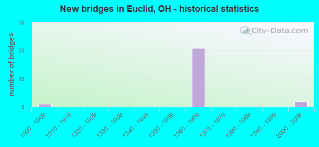
- New bridges - historical statistics
- 11900-1909
- 211960-1969
- 22000-2009

- Reconstructed bridges - Historical Statistics
- 31980-1989
- 01990-1999
- 02000-2009
- 02010-2019
- 42020-2022


- Bridge Condition - Deck
- 30.8%Excellent
- 23.1%Very good
- 46.2%Good

- Bridge Condition - Superstructure
- 28.6%Excellent
- 7.1%Very good
- 64.3%Good

- Bridge Condition - Substructure
- 14.3%Very good
- 50.0%Good
- 35.7%Satisfactory

- Bridge Condition - Channel
- 40.0%Good
- 40.0%Fair
- 20.0%Serious
Find on map >> Show street view
Structure Number: 1801082, Location: APPROX 500FT E DILLE RD (Lat: 41.568281, Lng: -81.535950), Route carried "on" structure: US 6, Year Built: 1902, Status: Open, Structure Length: 1.52m (4.99ft), Average Daily Traffic: 22,823 (year 2015), Truck Traffic: 3%, Average Future Daily Traffic: 31,678 (year 2035), Design Load: H 15, Features Intersected: EUCLID CREEK
Minimum Vertical Clearance: 30+ m (98+ ft), Kilometerpoint: 40.829, Lanes on structure: 5, Base Highway Network: Yes, Owner: State Highway Agency, Approaching Roadway Width: 17.1m (56.1ft), Skew: 2 degrees, Material/Design: Concrete, Design/Construction: Arch - Deck, Number Of Spans In Main Unit: 1, Length of Maximum Span: 15.2m (49.9ft), Curb or Sidewalk Widths: Left: 1.5m (4.9ft), Right: 1.5m (4.9ft), Curb-To-Curb Width: 17.3m (56.8ft), Out-to-Out Width: 29.4m (96.5ft)
Condition: Superstructure: Good, Substructure: Good, Channel: Fair, Operating Rating: 40.8 metric tons, Method Used To Determine Operating Rating: Field evaluation and documented engineering judgment, Inventory Rating: 32.7 metric tons, Method Used To Determine Inventory Rating: Field evaluation and documented engineering judgment, Structural Evaluation: Better than present minimum criteria, Deck Geometry: High priority of replacement, Waterway Adequacy: Equal to present desirable criteria, Approach Roadway Alignment: Equal to present desirable criteria, Length Of Structure Improvement: 6.10m (20.01ft), Designated Inspection Frequency: Every 12 months, Inspection Date: November 2021, Bridge Improvement Cost: $500,000, Roadway Improvement Cost: $500,000, Total Project Cost: $1,000,000, Wearing Surface/Protective System: Wearing Surface: Integral Concrete
Find on map >> Show street view
Structure Number: 1808915, Location: 1.56 MI W OF JCT SR175 (Lat: 41.587261, Lng: -81.526881), Route carried "on" structure: Interstate 90, Year Built: 1963, Year Reconstructed: 1993, Status: Open, Structure Length: 7.04m (23.10ft), Average Daily Traffic: 109,438 (year 2015), Truck Traffic: 4%, Average Future Daily Traffic: 151,900 (year 2035), Design Load: HS 20+Mod, Features Intersected: CR 44 (E 222 ST)
Minimum Vertical Clearance: 30+ m (98+ ft), Kilometerpoint: 44.321, Lanes on structure: 8, Lanes under structure: 8, Base Highway Network: Yes, Owner: State Highway Agency, Approaching Roadway Width: 50.0m (164.0ft), Skew: 33 degrees, Material/Design: Steel continuous, Design/Construction: Stringer/Multi-beam, Number Of Spans In Main Unit: 4, Length of Maximum Span: 18.3m (60.0ft), Curb-To-Curb Width: 50.0m (164.0ft), Out-to-Out Width: 50.6m (166.0ft)
Condition: Deck: Good, Superstructure: Good, Substructure: Satisfactory, Operating Rating: 42.1 metric tons, Method Used To Determine Operating Rating: Allowable Stress (AS) rating reported by rating factor (RF) method using MS18 loading, Inventory Rating: 32.4 metric tons, Method Used To Determine Inventory Rating: Allowable Stress (AS) rating reported by rating factor (RF) method using MS18 loading, Structural Evaluation: Equal to present minimum criteria, Deck Geometry: Superior to present desirable criteria, Underclear: High priority of corrective action, Approach Roadway Alignment: Equal to present desirable criteria, Designated Inspection Frequency: Every 12 months, Inspection Date: December 2021, Deck Structure Type: Concrete Cast-file-Place, Wearing Surface/Protective System: Wearing Surface: Monolithic Concrete, Deck Protection: Epoxy Coated Reinforcing
Find on map >> Show street view
Structure Number: 1808974, Location: .70 MI W OF JCT SR175 (Lat: 41.594919, Lng: -81.513681), Route carried "on" structure: Interstate 90, Year Built: 1963, Year Reconstructed: 1993, Status: Open, Structure Length: 6.37m (20.90ft), Average Daily Traffic: 113,245 (year 2015), Truck Traffic: 4%, Average Future Daily Traffic: 157,184 (year 2035), Design Load: HS 20+Mod, Features Intersected: CR 116 (BABBITT RD)
Minimum Vertical Clearance: 30+ m (98+ ft), Kilometerpoint: 45.705, Lanes on structure: 8, Lanes under structure: 6, Base Highway Network: Yes, Owner: State Highway Agency, Approaching Roadway Width: 42.7m (140.1ft), Skew: 30 degrees, Material/Design: Steel continuous, Design/Construction: Stringer/Multi-beam, Number Of Spans In Main Unit: 3, Length of Maximum Span: 25.9m (85.0ft), Curb-To-Curb Width: 42.7m (140.1ft), Out-to-Out Width: 43.3m (142.1ft)
Condition: Deck: Good, Superstructure: Good, Substructure: Good, Operating Rating: 42.1 metric tons, Method Used To Determine Operating Rating: Allowable Stress (AS) rating reported by rating factor (RF) method using MS18 loading, Inventory Rating: 32.4 metric tons, Method Used To Determine Inventory Rating: Allowable Stress (AS) rating reported by rating factor (RF) method using MS18 loading, Structural Evaluation: Better than present minimum criteria, Deck Geometry: Superior to present desirable criteria, Underclear: Meets minimum limits, Approach Roadway Alignment: Equal to present desirable criteria, Designated Inspection Frequency: Every 24 months, Inspection Date: December 2021, Deck Structure Type: Concrete Cast-file-Place, Wearing Surface/Protective System: Wearing Surface: Monolithic Concrete, Deck Protection: Epoxy Coated Reinforcing
Find on map >> Show street view
Structure Number: 1809008, Location: IR90 AND SR175 JCT (Lat: 41.601300, Lng: -81.503039), Route carried "on" structure: Interstate 90, Year Built: 1963, Year Reconstructed: 1993, Status: Open, Structure Length: 8.11m (26.61ft), Average Daily Traffic: 115,513 (year 2015), Truck Traffic: 4%, Average Future Daily Traffic: 160,332 (year 2035), Design Load: HS 20+Mod, Features Intersected: SR 175 (1446) E 260 ST
Minimum Vertical Clearance: 30+ m (98+ ft), Kilometerpoint: 46.832, Lanes on structure: 8, Lanes under structure: 6, Base Highway Network: Yes, Owner: State Highway Agency, Approaching Roadway Width: 42.7m (140.1ft), Skew: 13 degrees, Material/Design: Steel continuous, Design/Construction: Stringer/Multi-beam, Number Of Spans In Main Unit: 5, Length of Maximum Span: 18.9m (62.0ft), Curb-To-Curb Width: 42.7m (140.1ft), Out-to-Out Width: 43.3m (142.1ft)
Condition: Deck: Good, Superstructure: Good, Substructure: Good, Operating Rating: 42.1 metric tons, Method Used To Determine Operating Rating: Allowable Stress (AS) rating reported by rating factor (RF) method using MS18 loading, Inventory Rating: 32.4 metric tons, Method Used To Determine Inventory Rating: Allowable Stress (AS) rating reported by rating factor (RF) method using MS18 loading, Structural Evaluation: Better than present minimum criteria, Deck Geometry: Superior to present desirable criteria, Underclear: Meets minimum limits, Approach Roadway Alignment: Equal to present desirable criteria, Designated Inspection Frequency: Every 24 months, Inspection Date: November 2021, Deck Structure Type: Concrete Cast-file-Place, Wearing Surface/Protective System: Wearing Surface: Monolithic Concrete, Deck Protection: Epoxy Coated Reinforcing
Find on map >> Show street view
Structure Number: 1809164, Location: 4 MI W OF SR 640 (Lat: 41.605550, Lng: -81.494319), Route carried "on" structure: Interstate 90, Year Built: 2006, Status: Open, Structure Length: 7.22m (23.69ft), Average Daily Traffic: 15,678 (year 2015), Truck Traffic: 4%, Average Future Daily Traffic: 21,761 (year 2035), Design Load: HS 25 or greater, Features Intersected: SR 2 EB & SR-2 RAMP ES
Minimum Vertical Clearance: 30+ m (98+ ft), Kilometerpoint: 47.572, Lanes on structure: 2, Lanes under structure: 2, Base Highway Network: Yes, Owner: State Highway Agency, Approaching Roadway Width: 16.5m (54.1ft), Material/Design: Steel continuous, Design/Construction: Stringer/Multi-beam, Number Of Spans In Main Unit: 3, Length of Maximum Span: 30.6m (100.4ft), Curb-To-Curb Width: 16.5m (54.1ft), Out-to-Out Width: 17.4m (57.1ft)
Condition: Deck: Very good, Superstructure: Very good, Substructure: Very good, Operating Rating: 97.2 metric tons, Method Used To Determine Operating Rating: Load Factor (LF) rating reported by rating factor (RF) method using MS18 loading, Inventory Rating: 71.3 metric tons, Method Used To Determine Inventory Rating: Load Factor (LF) rating reported by rating factor (RF) method using MS18 loading, Structural Evaluation: Equal to present desirable criteria, Deck Geometry: Superior to present desirable criteria, Underclear: High priority of corrective action, Approach Roadway Alignment: Superior to present desirable criteria, Designated Inspection Frequency: Every 24 months, Inspection Date: May 2021, Deck Structure Type: Concrete Cast-file-Place, Wearing Surface/Protective System: Wearing Surface: Monolithic Concrete, Membrane: Epoxy, Deck Protection: Epoxy Coated Reinforcing
Find on map >> Show street view
Structure Number: 180918, Location: 4.5 MI W SR 640 (Lat: 41.605861, Lng: -81.494531), Route carried "on" structure: Ramp Interstate 90, Year Built: 1963, Status: Open, Structure Length: 5.40m (17.72ft), Average Daily Traffic: 12,173 (year 2016), Truck Traffic: 5%, Average Future Daily Traffic: 16,896 (year 2036), Design Load: HS 20+Mod, Features Intersected: SR 2 EB
Minimum Vertical Clearance: 4.60m (15.09ft), Kilometerpoint: 0.269, Lanes on structure: 2, Lanes under structure: 2, Owner: State Highway Agency, Approaching Roadway Width: 9.4m (30.8ft), Skew: 3 degrees, Material/Design: Steel continuous, Design/Construction: Stringer/Multi-beam, Number Of Spans In Main Unit: 3, Length of Maximum Span: 21.3m (69.9ft), Curb-To-Curb Width: 9.4m (30.8ft), Out-to-Out Width: 10.1m (33.1ft)
Condition: Deck: Good, Superstructure: Good, Substructure: Satisfactory, Operating Rating: 55.1 metric tons, Method Used To Determine Operating Rating: Load Factor (LF) rating reported by rating factor (RF) method using MS18 loading, Inventory Rating: 32.4 metric tons, Method Used To Determine Inventory Rating: Load Factor (LF) rating reported by rating factor (RF) method using MS18 loading, Structural Evaluation: Equal to present minimum criteria, Deck Geometry: Meets minimum limits, Underclear: High priority of corrective action, Approach Roadway Alignment: Equal to present desirable criteria, Designated Inspection Frequency: Every 12 months, Inspection Date: October 2021, Deck Structure Type: Concrete Cast-file-Place
Find on map >> Show street view
Structure Number: 180921, Location: .59 MI E OF JCT SR175 (Lat: 41.603989, Lng: -81.492281), Route carried "on" structure: Interstate 90, Year Built: 1963, Status: Open, Structure Length: 8.84m (29.00ft), Average Daily Traffic: 15,678 (year 2015), Truck Traffic: 4%, Average Future Daily Traffic: 21,761 (year 2035), Design Load: HS 20+Mod, Features Intersected: LAKELAND BLVD & CSX RR
Minimum Vertical Clearance: 30+ m (98+ ft), Kilometerpoint: 47.781, Lanes on structure: 2, Base Highway Network: Yes, Owner: State Highway Agency, Approaching Roadway Width: 21.0m (68.9ft), Skew: 1 degrees, Material/Design: Steel continuous, Design/Construction: Stringer/Multi-beam, Number Of Spans In Main Unit: 4, Length of Maximum Span: 28.3m (92.8ft), Curb-To-Curb Width: 21.0m (68.9ft), Out-to-Out Width: 21.6m (70.9ft)
Condition: Deck: Very good, Superstructure: Good, Substructure: Good, Operating Rating: 38.9 metric tons, Method Used To Determine Operating Rating: Load and Resistance Factor Rating (LRFR) rating reported by rating factor(RF) method using HL-93 loadings, Inventory Rating: 29.2 metric tons, Method Used To Determine Inventory Rating: Load and Resistance Factor Rating (LRFR) rating reported by rating factor(RF) method using HL-93 loadings, Structural Evaluation: Better than present minimum criteria, Deck Geometry: Superior to present desirable criteria, Underclear: Meets minimum limits, Approach Roadway Alignment: Equal to present minimum criteria, Designated Inspection Frequency: Every 24 months, Inspection Date: September 2021, Deck Structure Type: Concrete Cast-file-Place, Wearing Surface/Protective System: Wearing Surface: Latex Concrete, Membrane: Built-up
Find on map >> Show street view
Structure Number: 1809245, Location: .59 MI E OF JCT SR 175 (Lat: 41.603761, Lng: -81.492861), Route carried "on" structure: Interstate 90, Year Built: 1963, Status: Open, Structure Length: 8.66m (28.41ft), Average Daily Traffic: 15,678 (year 2015), Truck Traffic: 4%, Average Future Daily Traffic: 21,761 (year 2035), Design Load: HS 20+Mod, Features Intersected: LAKELAND BLVD & CSX RR
Minimum Vertical Clearance: 30+ m (98+ ft), Kilometerpoint: 47.781, Lanes on structure: 3, Base Highway Network: Yes, Owner: State Highway Agency, Approaching Roadway Width: 23.5m (77.1ft), Material/Design: Steel continuous, Design/Construction: Stringer/Multi-beam, Number Of Spans In Main Unit: 4, Length of Maximum Span: 28.0m (91.9ft), Curb-To-Curb Width: 23.6m (77.4ft), Out-to-Out Width: 24.2m (79.4ft)
Condition: Deck: Very good, Superstructure: Good, Substructure: Good, Operating Rating: 19.4 metric tons, Method Used To Determine Operating Rating: Load and Resistance Factor Rating (LRFR) rating reported by rating factor(RF) method using HL-93 loadings, Inventory Rating: 16.2 metric tons, Method Used To Determine Inventory Rating: Load and Resistance Factor Rating (LRFR) rating reported by rating factor(RF) method using HL-93 loadings, Structural Evaluation: Meets minimum limits, Deck Geometry: Superior to present desirable criteria, Underclear: Meets minimum limits, Approach Roadway Alignment: Equal to present desirable criteria, Designated Inspection Frequency: Every 24 months, Inspection Date: September 2021, Deck Structure Type: Concrete Cast-file-Place, Wearing Surface/Protective System: Wearing Surface: Latex Concrete, Membrane: Built-up
Find on map >> Show street view
Structure Number: 1809334, Location: .79 MI E OF JCT SR175 (Lat: 41.602000, Lng: -81.490289), Route carried "on" structure: Interstate 90, Year Built: 1963, Status: Open, Structure Length: 4.72m (15.49ft), Average Daily Traffic: 15,678 (year 2015), Truck Traffic: 4%, Average Future Daily Traffic: 21,761 (year 2035), Design Load: HS 20+Mod, Features Intersected: NSC RR
Minimum Vertical Clearance: 30+ m (98+ ft), Kilometerpoint: 48.103, Lanes on structure: 3, Base Highway Network: Yes, Owner: State Highway Agency, Approaching Roadway Width: 16.5m (54.1ft), Material/Design: Steel continuous, Design/Construction: Stringer/Multi-beam, Number Of Spans In Main Unit: 3, Length of Maximum Span: 19.2m (63.0ft), Curb-To-Curb Width: 16.5m (54.1ft), Out-to-Out Width: 17.2m (56.4ft)
Condition: Deck: Good, Superstructure: Good, Substructure: Good, Operating Rating: 42.1 metric tons, Method Used To Determine Operating Rating: Allowable Stress (AS) rating reported by rating factor (RF) method using MS18 loading, Inventory Rating: 32.4 metric tons, Method Used To Determine Inventory Rating: Allowable Stress (AS) rating reported by rating factor (RF) method using MS18 loading, Structural Evaluation: Better than present minimum criteria, Deck Geometry: Equal to present minimum criteria, Underclear: Meets minimum limits, Approach Roadway Alignment: Equal to present desirable criteria, Designated Inspection Frequency: Every 24 months, Inspection Date: September 2021, Deck Structure Type: Concrete Cast-file-Place, Wearing Surface/Protective System: Wearing Surface: Monolithic Concrete, Membrane: Built-up
Find on map >> Show street view
Structure Number: 1809369, Location: .79 MI E OF JCT SR 175 (Lat: 41.601861, Lng: -81.490531), Route carried "on" structure: Interstate 90, Year Built: 1963, Status: Open, Structure Length: 4.72m (15.49ft), Average Daily Traffic: 15,678 (year 2015), Truck Traffic: 4%, Average Future Daily Traffic: 21,761 (year 2035), Design Load: HS 20+Mod, Features Intersected: NSC RR
Minimum Vertical Clearance: 30+ m (98+ ft), Kilometerpoint: 48.103, Lanes on structure: 3, Base Highway Network: Yes, Owner: State Highway Agency, Approaching Roadway Width: 16.5m (54.1ft), Material/Design: Steel continuous, Design/Construction: Stringer/Multi-beam, Number Of Spans In Main Unit: 3, Length of Maximum Span: 19.2m (63.0ft), Curb-To-Curb Width: 16.5m (54.1ft), Out-to-Out Width: 17.1m (56.1ft)
Condition: Deck: Good, Superstructure: Good, Substructure: Good, Operating Rating: 42.1 metric tons, Method Used To Determine Operating Rating: Allowable Stress (AS) rating reported by rating factor (RF) method using MS18 loading, Inventory Rating: 32.4 metric tons, Method Used To Determine Inventory Rating: Allowable Stress (AS) rating reported by rating factor (RF) method using MS18 loading, Structural Evaluation: Better than present minimum criteria, Deck Geometry: Equal to present minimum criteria, Underclear: Meets minimum limits, Approach Roadway Alignment: Equal to present desirable criteria, Designated Inspection Frequency: Every 24 months, Inspection Date: September 2021, Deck Structure Type: Concrete Cast-file-Place, Wearing Surface/Protective System: Wearing Surface: Monolithic Concrete, Membrane: Built-up
Find on map >> Show street view
Structure Number: 1830325, Location: 590 FT SE OF EUCLID AVE (Lat: 41.566161, Lng: -81.535339), Route carried "on" structure: County highway 47, Year Built: 1968, Year Reconstructed: 2020, Status: Open, Structure Length: 4.05m (13.29ft), Average Daily Traffic: 10,520 (year 2015), Truck Traffic: 3%, Average Future Daily Traffic: 14,602 (year 2035), Design Load: HS 25 or greater, Features Intersected: EUCLID CREEK
Minimum Vertical Clearance: 30+ m (98+ ft), Kilometerpoint: 0.209, Lanes on structure: 4, Owner: County Highway Agency, Approaching Roadway Width: 15.9m (52.2ft), Material/Design: Steel continuous, Design/Construction: Stringer/Multi-beam, Number Of Spans In Main Unit: 3, Length of Maximum Span: 15.2m (49.9ft), Curb or Sidewalk Widths: Left: 2.4m (7.9ft), Right: 2.4m (7.9ft), Curb-To-Curb Width: 15.9m (52.2ft), Out-to-Out Width: 21.5m (70.5ft)
Condition: Deck: Excellent, Superstructure: Excellent, Substructure: Satisfactory, Channel: Serious, Operating Rating: 66.7 metric tons, Method Used To Determine Operating Rating: Load Factor (LF) rating reported by rating factor (RF) method using MS18 loading, Inventory Rating: 39.9 metric tons, Method Used To Determine Inventory Rating: Load Factor (LF) rating reported by rating factor (RF) method using MS18 loading, Structural Evaluation: Equal to present minimum criteria, Deck Geometry: Meets minimum limits, Waterway Adequacy: Superior to present desirable criteria, Approach Roadway Alignment: Superior to present desirable criteria, Designated Inspection Frequency: Every 12 months, Inspection Date: April 2021, Deck Structure Type: Concrete Cast-file-Place, Wearing Surface/Protective System: Wearing Surface: Monolithic Concrete
Find on map >> Show street view
Structure Number: 1830333, Location: 1592 FT SE OF EUCLID AVE (Lat: 41.564439, Lng: -81.532781), Route carried "on" structure: County highway 47, Year Built: 1968, Year Reconstructed: 2020, Status: Open, Structure Length: 4.59m (15.06ft), Average Daily Traffic: 13,500 (year 2018), Truck Traffic: 2%, Average Future Daily Traffic: 14,602 (year 2038), Design Load: HS 25 or greater, Features Intersected: EUCLID CREEK
Minimum Vertical Clearance: 30+ m (98+ ft), Kilometerpoint: 0.499, Lanes on structure: 4, Owner: County Highway Agency, Approaching Roadway Width: 15.9m (52.2ft), Skew: 2 degrees, Material/Design: Steel continuous, Design/Construction: Stringer/Multi-beam, Number Of Spans In Main Unit: 3, Length of Maximum Span: 17.3m (56.8ft), Curb or Sidewalk Widths: Left: 2.4m (7.9ft), Right: 2.4m (7.9ft), Curb-To-Curb Width: 16.7m (54.8ft), Out-to-Out Width: 22.3m (73.2ft)
Condition: Deck: Excellent, Superstructure: Excellent, Substructure: Satisfactory, Channel: Fair, Operating Rating: 69.3 metric tons, Method Used To Determine Operating Rating: Load Factor (LF) rating reported by rating factor (RF) method using MS18 loading, Inventory Rating: 41.5 metric tons, Method Used To Determine Inventory Rating: Load Factor (LF) rating reported by rating factor (RF) method using MS18 loading, Structural Evaluation: Equal to present minimum criteria, Deck Geometry: Somewhat better than minimum adequacy, Waterway Adequacy: Superior to present desirable criteria, Approach Roadway Alignment: Superior to present desirable criteria, Designated Inspection Frequency: Every 12 months, Inspection Date: April 2021, Deck Structure Type: Concrete Cast-file-Place, Wearing Surface/Protective System: Wearing Surface: Monolithic Concrete
Find on map >> Show street view
Structure Number: 1830341, Location: 2052 FT SE OF EUCLID AVE (Lat: 41.561489, Lng: -81.530219), Route carried "on" structure: County highway 47, Year Built: 1968, Year Reconstructed: 2020, Status: Open, Structure Length: 6.18m (20.28ft), Average Daily Traffic: 10,520 (year 2015), Truck Traffic: 3%, Average Future Daily Traffic: 14,602 (year 2035), Design Load: HS 25 or greater, Features Intersected: EUCLID CREEK
Minimum Vertical Clearance: 30+ m (98+ ft), Kilometerpoint: 0.869, Lanes on structure: 4, Owner: County Highway Agency, Approaching Roadway Width: 15.9m (52.2ft), Skew: 2 degrees, Material/Design: Steel continuous, Design/Construction: Stringer/Multi-beam, Number Of Spans In Main Unit: 3, Length of Maximum Span: 23.2m (76.1ft), Curb or Sidewalk Widths: Left: 2.4m (7.9ft), Right: 2.4m (7.9ft), Curb-To-Curb Width: 15.9m (52.2ft), Out-to-Out Width: 21.5m (70.5ft)
Condition: Deck: Excellent, Superstructure: Excellent, Substructure: Satisfactory, Channel: Good, Operating Rating: 63.5 metric tons, Method Used To Determine Operating Rating: Load Factor (LF) rating reported by rating factor (RF) method using MS18 loading, Inventory Rating: 38.2 metric tons, Method Used To Determine Inventory Rating: Load Factor (LF) rating reported by rating factor (RF) method using MS18 loading, Structural Evaluation: Equal to present minimum criteria, Deck Geometry: Meets minimum limits, Waterway Adequacy: Superior to present desirable criteria, Approach Roadway Alignment: Superior to present desirable criteria, Designated Inspection Frequency: Every 12 months, Inspection Date: April 2021, Deck Structure Type: Concrete Cast-file-Place, Wearing Surface/Protective System: Wearing Surface: Monolithic Concrete
Find on map >> Show street view
Structure Number: 1830368, Location: 3305 FT SE OF EUCLID AVE (Lat: 41.560400, Lng: -81.529469), Route carried "on" structure: County highway 47, Year Built: 1968, Year Reconstructed: 2020, Status: Open, Structure Length: 7.84m (25.72ft), Average Daily Traffic: 10,520 (year 2015), Truck Traffic: 3%, Average Future Daily Traffic: 14,602 (year 2035), Design Load: HS 25 or greater, Features Intersected: EUCLID CREEK
Minimum Vertical Clearance: 30+ m (98+ ft), Kilometerpoint: 1.030, Lanes on structure: 4, Owner: County Highway Agency, Approaching Roadway Width: 15.9m (52.2ft), Material/Design: Steel continuous, Design/Construction: Stringer/Multi-beam, Number Of Spans In Main Unit: 3, Length of Maximum Span: 29.7m (97.4ft), Curb or Sidewalk Widths: Left: 2.4m (7.9ft), Right: 2.4m (7.9ft), Curb-To-Curb Width: 15.9m (52.2ft), Out-to-Out Width: 21.5m (70.5ft)
Condition: Deck: Excellent, Superstructure: Excellent, Substructure: Very good, Channel: Good, Operating Rating: 57.0 metric tons, Method Used To Determine Operating Rating: Load Factor (LF) rating reported by rating factor (RF) method using MS18 loading, Inventory Rating: 34.0 metric tons, Method Used To Determine Inventory Rating: Load Factor (LF) rating reported by rating factor (RF) method using MS18 loading, Structural Evaluation: Equal to present desirable criteria, Deck Geometry: Meets minimum limits, Waterway Adequacy: Superior to present desirable criteria, Approach Roadway Alignment: Superior to present desirable criteria, Designated Inspection Frequency: Every 12 months, Inspection Date: April 2021, Deck Structure Type: Concrete Cast-file-Place, Wearing Surface/Protective System: Wearing Surface: Monolithic Concrete
Find on map >> Show street view
Structure Number: 1808915, Location: 1.56 MI W OF JCT SR175 (Lat: 41.587261, Lng: -81.526881), Route carried "under" structure: Ramp State highway 18513, Year Built: 1963, Structure Length: 0. m, Average Daily Traffic: 908 (year 2019), Truck Traffic: 2%, Features Intersected: IR-90, Facility Carried by Structure: IR90 OVER E-222ND
Minimum Vertical Clearance: 4.55m (14.93ft), Kilometerpoint: 0.000, Lanes on structure: 8, Lanes under structure: 8, Material/Design: Steel continuous, Design/Construction: Stringer/Multi-beam, Length of Maximum Span: 18.3m (60.0ft)
Find on map >> Show street view
Structure Number: 1808915, Location: 1.56 MI W OF JCT SR175 (Lat: 41.587261, Lng: -81.526881), Route carried "under" structure: County highway C0044, Year Built: 1963, Structure Length: 0. m, Average Daily Traffic: 9,170 (year 2015), Truck Traffic: 7%, Features Intersected: IR 90, Facility Carried by Structure: IR90 OVER E-222ND
Minimum Vertical Clearance: 4.57m (14.99ft), Kilometerpoint: 0.241, Lanes on structure: 8, Lanes under structure: 8, Material/Design: Steel continuous, Design/Construction: Stringer/Multi-beam, Length of Maximum Span: 18.3m (60.0ft)
Find on map >> Show street view
Structure Number: 1808915, Location: 1.56 MI W OF JCT SR175 (Lat: 41.587261, Lng: -81.526881), Route carried "under" structure: Ramp State highway 18512, Year Built: 1963, Structure Length: 0. m, Average Daily Traffic: 659 (year 2019), Truck Traffic: 2%, Features Intersected: IR-90, Facility Carried by Structure: IR90 OVER E-222ND
Minimum Vertical Clearance: 4.57m (14.99ft), Kilometerpoint: 0.000, Lanes on structure: 8, Lanes under structure: 8, Material/Design: Steel continuous, Design/Construction: Stringer/Multi-beam, Length of Maximum Span: 18.3m (60.0ft)
Find on map >> Show street view
Structure Number: 1808974, Location: .70 MI W OF JCT SR175 (Lat: 41.594919, Lng: -81.513681), Route carried "under" structure: Ramp State highway 18518, Year Built: 1963, Structure Length: 0. m, Average Daily Traffic: 595 (year 2019), Truck Traffic: 2%, Features Intersected: IR-90, Facility Carried by Structure: IR 90
Minimum Vertical Clearance: 4.83m (15.85ft), Kilometerpoint: 0.000, Lanes on structure: 8, Lanes under structure: 6, Material/Design: Steel continuous, Design/Construction: Stringer/Multi-beam, Length of Maximum Span: 25.9m (85.0ft)
Find on map >> Show street view
Structure Number: 1808974, Location: .70 MI W OF JCT SR175 (Lat: 41.594919, Lng: -81.513681), Route carried "under" structure: County highway 116, Year Built: 1963, Structure Length: 0. m, Average Daily Traffic: 6,912 (year 2015), Truck Traffic: 5%, Features Intersected: I-90, Facility Carried by Structure: IR 90
Minimum Vertical Clearance: 4.65m (15.26ft), Kilometerpoint: 1.271, Lanes on structure: 8, Lanes under structure: 6, Material/Design: Steel continuous, Design/Construction: Stringer/Multi-beam, Length of Maximum Span: 25.9m (85.0ft)
Find on map >> Show street view
Structure Number: 1808974, Location: .70 MI W OF JCT SR175 (Lat: 41.594919, Lng: -81.513681), Route carried "under" structure: Ramp State highway 18519, Year Built: 1963, Structure Length: 0. m, Average Daily Traffic: 2,996 (year 2019), Truck Traffic: 1%, Features Intersected: IR-90, Facility Carried by Structure: IR 90
Minimum Vertical Clearance: 4.57m (14.99ft), Kilometerpoint: 0.000, Lanes on structure: 8, Lanes under structure: 6, Material/Design: Steel continuous, Design/Construction: Stringer/Multi-beam, Length of Maximum Span: 25.9m (85.0ft)
Find on map >> Show street view
Structure Number: 1809008, Location: IR90 AND SR175 JCT (Lat: 41.601300, Lng: -81.503039), Route carried "under" structure: State highway 175, Year Built: 1963, Structure Length: 0. m, Average Daily Traffic: 15,315 (year 2019), Truck Traffic: 2%, Features Intersected: I-90, Facility Carried by Structure: IR 90 OVER E. 260T
Minimum Vertical Clearance: 4.62m (15.16ft), Kilometerpoint: 23.271, Lanes on structure: 8, Lanes under structure: 6, Material/Design: Steel continuous, Design/Construction: Stringer/Multi-beam, Length of Maximum Span: 18.9m (62.0ft)
Find on map >> Show street view
Structure Number: 1809008, Location: IR90 AND SR175 JCT (Lat: 41.601300, Lng: -81.503039), Route carried "under" structure: Ramp State highway 18524, Year Built: 1963, Structure Length: 0. m, Average Daily Traffic: 2,077 (year 2019), Truck Traffic: 1%, Features Intersected: IR-90, Facility Carried by Structure: IR 90 OVER E. 260T
Minimum Vertical Clearance: 4.52m (14.83ft), Kilometerpoint: 0.000, Lanes on structure: 8, Lanes under structure: 6, Material/Design: Steel continuous, Design/Construction: Stringer/Multi-beam, Length of Maximum Span: 18.9m (62.0ft)
Find on map >> Show street view
Structure Number: 1809164, Location: 4 MI W OF SR 640 (Lat: 41.605550, Lng: -81.494319), Route carried "under" structure: Ramp State highway 2, Year Built: 2006, Structure Length: 0. m, Average Daily Traffic: 71,420 (year 2010), Truck Traffic: 4%, Features Intersected: IR-90WB UP, SR-2 DOWN, Facility Carried by Structure: IR 90 WB
Minimum Vertical Clearance: 4.60m (15.09ft), Kilometerpoint: 45.834, Lanes on structure: 2, Lanes under structure: 2, Material/Design: Steel continuous, Design/Construction: Stringer/Multi-beam, Length of Maximum Span: 30.6m (100.4ft)
Find on map >> Show street view
Structure Number: 180918, Location: 4.5 MI W SR 640 (Lat: 41.605861, Lng: -81.494531), Route carried "under" structure: State highway 2, Year Built: 1963, Structure Length: 0. m, Average Daily Traffic: 29,594 (year 2016), Truck Traffic: 5%, Features Intersected: RMP TO EB IR90 FROM SR2
Minimum Vertical Clearance: 4.52m (14.83ft), Kilometerpoint: 45.853, Lanes on structure: 2, Lanes under structure: 2, Material/Design: Steel continuous, Design/Construction: Stringer/Multi-beam, Length of Maximum Span: 21.3m (69.9ft)