Bridge Statistics for Forest, Virginia (VA)
Condition, Traffic, Stress, Structural Evaluation, Project Costs
- National Bridge Inventory (NBI) Statistics
- 18Number of bridges
- 177ft / 53.8mTotal length
- $40,720,000Total costs
- 63,445Total average daily traffic
- 738Total average daily truck traffic
- 231,428Total future (year 2035) average daily traffic
- National Bridge Inventory (NBI) Registered Bridges for Forest
- No street view available for this location
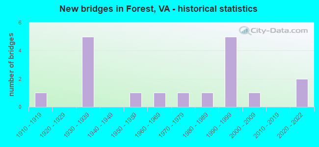
- New bridges - historical statistics
- 11910-1919
- 51930-1939
- 11950-1959
- 11960-1969
- 11970-1979
- 11980-1989
- 51990-1999
- 12000-2009
- 22020-2022


- Bridge Condition - Deck
- 11.8%Excellent
- 17.6%Very good
- 41.2%Good
- 11.8%Satisfactory
- 11.8%Fair
- 5.9%Poor

- Bridge Condition - Superstructure
- 11.8%Excellent
- 11.8%Very good
- 41.2%Good
- 11.8%Satisfactory
- 11.8%Fair
- 11.8%Poor

- Bridge Condition - Substructure
- 23.5%Very good
- 41.2%Good
- 5.9%Satisfactory
- 29.4%Fair

- Bridge Condition - Channel
- 63.6%Very good
- 36.4%Satisfactory
Find on map >> Show street view
Structure Number: 2621, Location: 0.28 Rt 662; 0.99 Rt 663 (Lat: 37.372447, Lng: -79.319739), Route carried "on" structure: US 221, Year Built: 1951, Status: Posted for load, Structure Length: 5.09m (16.70ft), Average Daily Traffic: 7,700 (year 2019), Truck Traffic: 4%, Average Future Daily Traffic: 154,000 (year 2039), Design Load: HS 20, Features Intersected: Elk Creek
Minimum Vertical Clearance: 30+ m (98+ ft), Kilometerpoint: 224.584, Lanes on structure: 2, Owner: State Highway Agency, Approaching Roadway Width: 7.3m (24.0ft), Material/Design: Steel, Design/Construction: Stringer/Multi-beam, Number Of Spans In Main Unit: 3, Length of Maximum Span: 16.8m (55.1ft), Curb or Sidewalk Widths: Left: 0.5m (1.6ft), Right: 0.5m (1.6ft), Curb-To-Curb Width: 8.5m (27.9ft), Out-to-Out Width: 10.1m (33.1ft)
Condition: Deck: Fair, Superstructure: Fair, Substructure: Fair, Channel: Satisfactory, Operating Rating: 39.0 metric tons, Method Used To Determine Operating Rating: Load Factor (LF), Inventory Rating: 23.6 metric tons, Method Used To Determine Inventory Rating: Load Factor (LF), Structural Evaluation: Somewhat better than minimum adequacy, Deck Geometry: High priority of replacement, Waterway Adequacy: Better than present minimum criteria, Approach Roadway Alignment: Equal to present minimum criteria, Length Of Structure Improvement: 6.10m (20.01ft), Designated Inspection Frequency: Every 24 months, Inspection Date: August 2020, Bridge Improvement Cost: $3,794,000, Roadway Improvement Cost: $1,328,000, Total Project Cost: $12,709,000 ( Estimate for 2019), Deck Structure Type: Concrete Cast-file-Place, Wearing Surface/Protective System: Wearing Surface: Latex Concrete
Find on map >> Show street view
Structure Number: 2706, Location: 0.90 RT 660; 0.15 RT 221 (Lat: 37.387444, Lng: -79.244244), Route carried "on" structure: County highway 621, Year Built: 1990, Status: Open, Structure Length: 3.75m (12.30ft), Average Daily Traffic: 6,250 (year 2020), Truck Traffic: 1%, Average Future Daily Traffic: 8,750 (year 2040), Design Load: HS 20+Mod, Features Intersected: N&W Railway
Minimum Vertical Clearance: 30+ m (98+ ft), Kilometerpoint: 10.695, Lanes on structure: 2, Owner: State Highway Agency, Approaching Roadway Width: 5.5m (18.0ft), Skew: 2 degrees, Material/Design: Steel, Design/Construction: Stringer/Multi-beam, Number Of Spans In Main Unit: 1, Length of Maximum Span: 37.5m (123.0ft), Curb-To-Curb Width: 11.7m (38.4ft), Out-to-Out Width: 12.7m (41.7ft)
Condition: Deck: Good, Superstructure: Good, Substructure: Good, Operating Rating: 49.9 metric tons, Method Used To Determine Operating Rating: Load and Resistance Factor (LRFR), Inventory Rating: 38.1 metric tons, Method Used To Determine Inventory Rating: Load and Resistance Factor (LRFR), Structural Evaluation: Better than present minimum criteria, Deck Geometry: Somewhat better than minimum adequacy, Underclear: Somewhat better than minimum adequacy, Approach Roadway Alignment: Equal to present desirable criteria, Designated Inspection Frequency: Every 24 months, Inspection Date: May 2020, Deck Structure Type: Concrete Cast-file-Place, Wearing Surface/Protective System: Deck Protection: Epoxy Coated Reinforcing
Find on map >> Show street view
Structure Number: 2709, Location: 1.13-RT 810;0.15-RT 785 (Lat: 37.347650, Lng: -79.344239), Route carried "on" structure: County highway 622, Year Built: 1961, Status: Open, Structure Length: 5.79m (19.00ft), Average Daily Traffic: 430 (year 2016), Average Future Daily Traffic: 636 (year 2040), Design Load: H 20, Features Intersected: ELK CREEK, Facility Carried by Structure: EVERETT ROAD/RT22
Minimum Vertical Clearance: 30+ m (98+ ft), Kilometerpoint: 3.532, Lanes on structure: 2, Owner: State Highway Agency, Approaching Roadway Width: 4.9m (16.1ft), Material/Design: Concrete, Design/Construction: Tee Beam, Number Of Spans In Main Unit: 5, Length of Maximum Span: 11.9m (39.0ft), Curb or Sidewalk Widths: Left: 0.5m (1.6ft), Right: 0.5m (1.6ft), Curb-To-Curb Width: 7.3m (24.0ft), Out-to-Out Width: 8.2m (26.9ft)
Condition: Deck: Good, Superstructure: Satisfactory, Substructure: Satisfactory, Channel: Satisfactory, Operating Rating: 47.2 metric tons, Method Used To Determine Operating Rating: Load and Resistance Factor (LRFR), Inventory Rating: 36.3 metric tons, Method Used To Determine Inventory Rating: Load and Resistance Factor (LRFR), Structural Evaluation: Equal to present minimum criteria, Deck Geometry: Meets minimum limits, Waterway Adequacy: Better than present minimum criteria, Approach Roadway Alignment: Equal to present desirable criteria, Length Of Structure Improvement: 5.79m (19.00ft), Designated Inspection Frequency: Every 24 months, Inspection Date: August 2021, Bridge Improvement Cost: $3,000, Roadway Improvement Cost: $1,000, Total Project Cost: $9,000 ( Estimate for 2021), Deck Structure Type: Concrete Cast-file-Place, Wearing Surface/Protective System: Wearing Surface: Epoxy Overlay
Find on map >> Show street view
Structure Number: 2743, Location: 2.35 Rt 705; 0.25 Rt 762 (Lat: 37.359692, Lng: -79.372025), Route carried "on" structure: County highway 643, Year Built: 1932, Status: Posted for load, Structure Length: 3.29m (10.79ft), Average Daily Traffic: 62 (year 2020), Average Future Daily Traffic: 87 (year 2040), Features Intersected: Norfolk Southern RR
Minimum Vertical Clearance: 30+ m (98+ ft), Kilometerpoint: 25.116, Lanes on structure: 1, Owner: State Highway Agency, Approaching Roadway Width: 4.3m (14.1ft), Material/Design: Steel, Design/Construction: Girder and Floorbeam System, Number Of Spans In Main Unit: 3, Length of Maximum Span: 11.3m (37.1ft), Curb or Sidewalk Widths: Left: 0.2m (0.7ft), Right: 0.2m (0.7ft), Curb-To-Curb Width: 4.4m (14.4ft), Out-to-Out Width: 4.9m (16.1ft)
Condition: Deck: Very good, Superstructure: Good, Substructure: Fair, Operating Rating: 24.5 metric tons, Method Used To Determine Operating Rating: Load Factor (LF), Inventory Rating: 14.5 metric tons, Method Used To Determine Inventory Rating: Load Factor (LF), Structural Evaluation: Meets minimum limits, Deck Geometry: Equal to present minimum criteria, Underclear: Meets minimum limits, Approach Roadway Alignment: High priority of corrective action, Bridge Posting: Required (Relationship of Operating Rating to Maximum Legal Load: 10.0 - 19.9% below), Length Of Structure Improvement: 3.66m (12.01ft), Designated Inspection Frequency: Every 12 months, Critical Feature Inspection Frequency: Every 12 months, Inspection Date: Febuary 2021, Critical Feature Inspection Date: Febuary 2021, Bridge Improvement Cost: $1,451,000, Roadway Improvement Cost: $363,000, Total Project Cost: $4,642,000 ( Estimate for 2019), Deck Structure Type: Wood or Timber
Find on map >> Show street view
Structure Number: 2744, Location: 0.25 Rt 705; 2.10 Rt 762 (Lat: 37.340819, Lng: -79.358806), Route carried "on" structure: County highway 643, Year Built: 1932, Status: Open, Structure Length: 1.07m (3.51ft), Average Daily Traffic: 62 (year 2020), Average Future Daily Traffic: 87 (year 2040), Design Load: HL 93, Features Intersected: Elk Creek
Minimum Vertical Clearance: 30+ m (98+ ft), Kilometerpoint: 28.376, Lanes on structure: 1, Owner: State Highway Agency, Approaching Roadway Width: 3.7m (12.1ft), Material/Design: Steel, Design/Construction: Stringer/Multi-beam, Number Of Spans In Main Unit: 1, Length of Maximum Span: 10.7m (35.1ft), Curb or Sidewalk Widths: Left: 0.2m (0.7ft), Right: 0.2m (0.7ft), Curb-To-Curb Width: 3.5m (11.5ft), Out-to-Out Width: 4.3m (14.1ft)
Condition: Deck: Very good, Superstructure: Very good, Substructure: Very good, Channel: Very good, Operating Rating: 61.7 metric tons, Method Used To Determine Operating Rating: Load and Resistance Factor (LRFR), Inventory Rating: 48.1 metric tons, Method Used To Determine Inventory Rating: Load and Resistance Factor (LRFR), Structural Evaluation: Equal to present desirable criteria, Deck Geometry: High priority of corrective action, Waterway Adequacy: Meets minimum limits, Approach Roadway Alignment: Equal to present minimum criteria, Length Of Structure Improvement: 1.11m (3.64ft), Designated Inspection Frequency: Every 24 months, Inspection Date: October 2020, Bridge Improvement Cost: $326,000, Roadway Improvement Cost: $81,000, Total Project Cost: $1,042,000 ( Estimate for 2020), Deck Structure Type: Wood or Timber, Wearing Surface/Protective System: Wearing Surface: Bituminous, Membrane: Other
Find on map >> Show street view
Structure Number: 2779, Location: 0.40 Rt 646; 0.30 End Mt (Lat: 37.385264, Lng: -79.348697), Route carried "on" structure: County highway 664, Year Built: 1932, Status: Posted for load, Structure Length: 0.82m (2.69ft), Average Daily Traffic: 45 (year 2019), Average Future Daily Traffic: 51 (year 2040), Features Intersected: Elk Creek
Minimum Vertical Clearance: 30+ m (98+ ft), Kilometerpoint: 0.644, Lanes on structure: 1, Owner: State Highway Agency, Approaching Roadway Width: 3.0m (9.8ft), Material/Design: Steel, Design/Construction: Stringer/Multi-beam, Number Of Spans In Main Unit: 1, Length of Maximum Span: 8.2m (26.9ft), Curb or Sidewalk Widths: Left: 0.2m (0.7ft), Right: 0.2m (0.7ft), Curb-To-Curb Width: 3.7m (12.1ft), Out-to-Out Width: 3.9m (12.8ft)
Condition: Deck: Satisfactory, Superstructure: Fair, Substructure: Fair, Channel: Very good, Operating Rating: 21.8 metric tons, Method Used To Determine Operating Rating: Load Factor (LF), Inventory Rating: 12.7 metric tons, Method Used To Determine Inventory Rating: Load Factor (LF), Structural Evaluation: Meets minimum limits, Deck Geometry: Meets minimum limits, Waterway Adequacy: Better than present minimum criteria, Approach Roadway Alignment: High priority of corrective action, Bridge Posting: Required (Relationship of Operating Rating to Maximum Legal Load: 30.0 - 39.9% below), Length Of Structure Improvement: 0.82m (2.69ft), Designated Inspection Frequency: Every 12 months, Inspection Date: March 2021, Bridge Improvement Cost: $156,000, Roadway Improvement Cost: $55,000, Total Project Cost: $507,000 ( Estimate for 2020), Deck Structure Type: Wood or Timber
Find on map >> Show street view
Structure Number: 2781, Location: 1.80 Rt 622; 1.60 Rt 221 (Lat: 37.364153, Lng: -79.323047), Route carried "on" structure: County highway 666, Year Built: 1915, Status: Posted for load, Structure Length: 3.35m (10.99ft), Average Daily Traffic: 130 (year 2020), Average Future Daily Traffic: 182 (year 2040), Features Intersected: Elk Creek
Minimum Vertical Clearance: 30+ m (98+ ft), Kilometerpoint: 3.057, Lanes on structure: 1, Owner: State Highway Agency, Approaching Roadway Width: 4.3m (14.1ft), Material/Design: Steel, Design/Construction: Truss - Deck, Number Of Spans In Main Unit: 1, Length of Maximum Span: 33.5m (109.9ft), Curb or Sidewalk Widths: Left: 0.2m (0.7ft), Right: 0.2m (0.7ft), Curb-To-Curb Width: 3.4m (11.2ft), Out-to-Out Width: 3.7m (12.1ft)
Condition: Deck: Poor, Superstructure: Poor, Substructure: Good, Channel: Satisfactory, Operating Rating: 21.8 metric tons, Method Used To Determine Operating Rating: Load Factor (LF), Inventory Rating: 12.7 metric tons, Method Used To Determine Inventory Rating: Load Factor (LF), Structural Evaluation: Meets minimum limits, Deck Geometry: High priority of replacement, Waterway Adequacy: Better than present minimum criteria, Approach Roadway Alignment: Equal to present desirable criteria, Bridge Posting: Required (Relationship of Operating Rating to Maximum Legal Load: 20.0 - 29.9% below), Length Of Structure Improvement: 4.27m (14.01ft), Designated Inspection Frequency: Every 12 months, Critical Feature Inspection Frequency: Every 12 months, Inspection Date: August 2021, Critical Feature Inspection Date: August 2021, Bridge Improvement Cost: $1,020,000, Roadway Improvement Cost: $255,000, Total Project Cost: $3,263,000 ( Estimate for 2019), Deck Structure Type: Wood or Timber
Find on map >> Show street view
Structure Number: 2782, Location: 0.70 Rt 622; 2.80 Rt 221 (Lat: 37.365031, Lng: -79.341208), Route carried "on" structure: County highway 666, Year Built: 1932, Status: Posted for load, Structure Length: 2.93m (9.61ft), Average Daily Traffic: 130 (year 2020), Average Future Daily Traffic: 182 (year 2040), Features Intersected: Norfolk Southern RR
Minimum Vertical Clearance: 30+ m (98+ ft), Kilometerpoint: 1.097, Lanes on structure: 1, Owner: State Highway Agency, Approaching Roadway Width: 3.7m (12.1ft), Material/Design: Steel, Design/Construction: Girder and Floorbeam System, Number Of Spans In Main Unit: 3, Length of Maximum Span: 11.3m (37.1ft), Curb or Sidewalk Widths: Left: 0.2m (0.7ft), Right: 0.2m (0.7ft), Curb-To-Curb Width: 3.4m (11.2ft), Out-to-Out Width: 3.7m (12.1ft)
Condition: Deck: Fair, Superstructure: Poor, Substructure: Fair, Operating Rating: 12.7 metric tons, Method Used To Determine Operating Rating: Allowable Stress (AS), Inventory Rating: 9.1 metric tons, Method Used To Determine Inventory Rating: Allowable Stress (AS), Structural Evaluation: High priority of corrective action, Deck Geometry: High priority of replacement, Underclear: Meets minimum limits, Approach Roadway Alignment: Meets minimum limits, Bridge Posting: Required (Relationship of Operating Rating to Maximum Legal Load: > 39.9% below), Length Of Structure Improvement: 2.93m (9.61ft), Designated Inspection Frequency: Every 12 months, Critical Feature Inspection Frequency: Every 12 months, Inspection Date: May 2021, Critical Feature Inspection Date: May 2021, Bridge Improvement Cost: $2,462,000, Roadway Improvement Cost: $615,000, Total Project Cost: $7,877,000 ( Estimate for 2019), Deck Structure Type: Wood or Timber
Find on map >> Show street view
Structure Number: 2786, Location: 1.00-RT 221;0.70-RT 643 (Lat: 37.381028, Lng: -79.389917), Route carried "on" structure: County highway 668, Year Built: 1932, Year Reconstructed: 2018, Status: Open, Structure Length: 0.94m (3.08ft), Average Daily Traffic: 872 (year 2010), Average Future Daily Traffic: 1,003 (year 2040), Features Intersected: Chestnut Branch
Minimum Vertical Clearance: 30+ m (98+ ft), Kilometerpoint: 19.051, Lanes on structure: 2, Owner: State Highway Agency, Approaching Roadway Width: 6.1m (20.0ft), Skew: 4 degrees, Material/Design: Prestressed concrete, Design/Construction: Box Beam or Girders - Multiple, Number Of Spans In Main Unit: 1, Length of Maximum Span: 8.0m (26.2ft), Curb or Sidewalk Widths: Left: 0.4m (1.3ft), Right: 0.4m (1.3ft), Curb-To-Curb Width: 6.6m (21.7ft), Out-to-Out Width: 7.3m (24.0ft)
Condition: Deck: Very good, Superstructure: Very good, Substructure: Good, Channel: Very good, Operating Rating: 77.1 metric tons, Method Used To Determine Operating Rating: Load and Resistance Factor (LRFR), Inventory Rating: 59.9 metric tons, Method Used To Determine Inventory Rating: Load and Resistance Factor (LRFR), Structural Evaluation: Better than present minimum criteria, Deck Geometry: High priority of corrective action, Waterway Adequacy: Equal to present minimum criteria, Approach Roadway Alignment: Equal to present minimum criteria, Designated Inspection Frequency: Every 24 months, Inspection Date: April 2020, Wearing Surface/Protective System: Wearing Surface: Bituminous
Find on map >> Show street view
Structure Number: 2915, Location: 0.30 RT 644; 1.10 RT 621 (Lat: 37.420183, Lng: -79.327078), Route carried "on" structure: County highway 781, Year Built: 1976, Status: Posted for load, Structure Length: 1.10m (3.61ft), Average Daily Traffic: 159 (year 2016), Average Future Daily Traffic: 235 (year 2040), Features Intersected: Ivy Creek
Minimum Vertical Clearance: 30+ m (98+ ft), Kilometerpoint: 0.473, Lanes on structure: 2, Owner: State Highway Agency, Approaching Roadway Width: 4.9m (16.1ft), Skew: 3 degrees, Material/Design: Steel, Design/Construction: Stringer/Multi-beam, Number Of Spans In Main Unit: 1, Length of Maximum Span: 11.0m (36.1ft), Curb or Sidewalk Widths: Left: 0.2m (0.7ft), Right: 0.2m (0.7ft), Curb-To-Curb Width: 6.1m (20.0ft), Out-to-Out Width: 6.4m (21.0ft)
Condition: Deck: Good, Superstructure: Good, Substructure: Good, Channel: Very good, Operating Rating: 34.5 metric tons, Method Used To Determine Operating Rating: Load Factor (LF), Inventory Rating: 20.0 metric tons, Method Used To Determine Inventory Rating: Load Factor (LF), Structural Evaluation: Somewhat better than minimum adequacy, Deck Geometry: Meets minimum limits, Waterway Adequacy: Better than present minimum criteria, Approach Roadway Alignment: Equal to present minimum criteria, Length Of Structure Improvement: 1.10m (3.61ft), Designated Inspection Frequency: Every 24 months, Inspection Date: October 2020, Bridge Improvement Cost: $339,000, Roadway Improvement Cost: $119,000, Total Project Cost: $1,102,000 ( Estimate for 2020), Deck Structure Type: Wood or Timber, Wearing Surface/Protective System: Wearing Surface: Bituminous
Find on map >> Show street view
Structure Number: 293, Location: 0.08 Rt 609; 0.70 Rt 661 (Lat: 37.361144, Lng: -79.285778), Route carried "on" structure: County highway 811, Year Built: 1987, Status: Open, Structure Length: 4.64m (15.22ft), Average Daily Traffic: 12,383 (year 2020), Truck Traffic: 1%, Average Future Daily Traffic: 17,336 (year 2040), Features Intersected: NS Railway
Minimum Vertical Clearance: 30+ m (98+ ft), Kilometerpoint: 12.505, Lanes on structure: 2, Owner: State Highway Agency, Approaching Roadway Width: 7.3m (24.0ft), Skew: 3 degrees, Material/Design: Steel, Design/Construction: Stringer/Multi-beam, Number Of Spans In Main Unit: 3, Length of Maximum Span: 18.3m (60.0ft), Curb-To-Curb Width: 9.9m (32.5ft), Out-to-Out Width: 10.9m (35.8ft)
Condition: Deck: Satisfactory, Superstructure: Satisfactory, Substructure: Fair, Operating Rating: 73.5 metric tons, Method Used To Determine Operating Rating: Load and Resistance Factor (LRFR), Inventory Rating: 56.2 metric tons, Method Used To Determine Inventory Rating: Load and Resistance Factor (LRFR), Structural Evaluation: Somewhat better than minimum adequacy, Deck Geometry: Meets minimum limits, Underclear: Equal to present minimum criteria, Approach Roadway Alignment: Equal to present desirable criteria, Designated Inspection Frequency: Every 24 months, Inspection Date: November 2020, Deck Structure Type: Concrete Cast-file-Place, Wearing Surface/Protective System: Deck Protection: Epoxy Coated Reinforcing
Find on map >> Show street view
Structure Number: 23857, Location: 2.50 Lychbg; 1.60 Rt 811 (Lat: 37.368358, Lng: -79.256339), Route carried "on" structure: US 221, Year Built: 1994, Status: Open, Structure Length: 7.38m (24.21ft), Average Daily Traffic: 21,370 (year 2020), Truck Traffic: 1%, Average Future Daily Traffic: 29,918 (year 2040), Design Load: HS 20+Mod, Features Intersected: Norfolk Southern Railway
Minimum Vertical Clearance: 30+ m (98+ ft), Kilometerpoint: 0.193, Lanes on structure: 4, Owner: State Highway Agency, Approaching Roadway Width: 17.7m (58.1ft), Skew: 26 degrees, Material/Design: Steel continuous, Design/Construction: Stringer/Multi-beam, Number Of Spans In Main Unit: 3, Length of Maximum Span: 36.0m (118.1ft), Curb or Sidewalk Widths: Left: 1.5m (4.9ft), Right: 1.5m (4.9ft), Curb-To-Curb Width: 17.7m (58.1ft), Out-to-Out Width: 21.5m (70.5ft)
Condition: Deck: Good, Superstructure: Good, Substructure: Good, Operating Rating: 46.3 metric tons, Method Used To Determine Operating Rating: Load and Resistance Factor (LRFR), Inventory Rating: 35.4 metric tons, Method Used To Determine Inventory Rating: Load and Resistance Factor (LRFR), Structural Evaluation: Better than present minimum criteria, Deck Geometry: Somewhat better than minimum adequacy, Underclear: Better than present minimum criteria, Approach Roadway Alignment: Equal to present desirable criteria, Designated Inspection Frequency: Every 24 months, Inspection Date: Febuary 2020, Deck Structure Type: Concrete Cast-file-Place, Wearing Surface/Protective System: Wearing Surface: Epoxy Overlay, Deck Protection: Epoxy Coated Reinforcing
Find on map >> Show street view
Structure Number: 24385, Location: 0.15-RT 1432;0.35-RT 1439 (Lat: 37.407667, Lng: -79.323933), Route carried "on" structure: County highway 1431, Year Built: 1995, Status: Open, Structure Length: 1.04m (3.41ft), Average Daily Traffic: 1,492 (year 2019), Average Future Daily Traffic: 1,649 (year 2040), Design Load: HS 20+Mod, Features Intersected: IVY CREEK, Facility Carried by Structure: QUAIL RIDGE RD.
Minimum Vertical Clearance: 30+ m (98+ ft), Kilometerpoint: 1.384, Lanes on structure: 2, Owner: State Highway Agency, Approaching Roadway Width: 6.1m (20.0ft), Material/Design: Concrete, Design/Construction: Culvert, Number Of Spans In Main Unit: 3, Length of Maximum Span: 3.0m (9.8ft)
Condition: Channel: Satisfactory, Culverts: Good, Operating Rating: 89.8 metric tons, Method Used To Determine Operating Rating: Load Factor (LF), Inventory Rating: 89.8 metric tons, Method Used To Determine Inventory Rating: Load Factor (LF), Structural Evaluation: Better than present minimum criteria, Waterway Adequacy: Better than present minimum criteria, Approach Roadway Alignment: Equal to present minimum criteria, Length Of Structure Improvement: 1.04m (3.41ft), Designated Inspection Frequency: Every 24 months, Inspection Date: November 2021, Bridge Improvement Cost: $491,000, Roadway Improvement Cost: $123,000, Total Project Cost: $1,572,000 ( Estimate for 2019)
Find on map >> Show street view
Structure Number: 24481, Location: 0.95 Rt 621; 0.01 Rt 657 (Lat: 37.433525, Lng: -79.322811), Route carried "on" structure: County highway 644, Year Built: 1995, Status: Open, Structure Length: 0.88m (2.89ft), Average Daily Traffic: 305 (year 2020), Truck Traffic: 3%, Average Future Daily Traffic: 425 (year 2040), Features Intersected: Ivy Creek
Minimum Vertical Clearance: 30+ m (98+ ft), Kilometerpoint: 26.243, Lanes on structure: 2, Owner: State Highway Agency, Approaching Roadway Width: 5.5m (18.0ft), Skew: 3 degrees, Material/Design: Concrete, Design/Construction: Slab, Number Of Spans In Main Unit: 1, Length of Maximum Span: 8.2m (26.9ft), Curb-To-Curb Width: 6.5m (21.3ft), Out-to-Out Width: 7.7m (25.3ft)
Condition: Deck: Good, Superstructure: Good, Substructure: Good, Channel: Very good, Operating Rating: 89.8 metric tons, Method Used To Determine Operating Rating: Load and Resistance Factor (LRFR), Inventory Rating: 88.9 metric tons, Method Used To Determine Inventory Rating: Load and Resistance Factor (LRFR), Structural Evaluation: Better than present minimum criteria, Deck Geometry: Meets minimum limits, Waterway Adequacy: Meets minimum limits, Approach Roadway Alignment: Equal to present desirable criteria, Designated Inspection Frequency: Every 24 months, Inspection Date: December 2021, Deck Structure Type: Concrete Cast-file-Place, Wearing Surface/Protective System: Deck Protection: Epoxy Coated Reinforcing
Find on map >> Show street view
Structure Number: 24849, Location: 0.28 RT 620; 1.00 RT 811 (Lat: 37.359619, Lng: -79.267661), Route carried "on" structure: Alternate County highway 661, Year Built: 1997, Status: Open, Structure Length: 4.54m (14.90ft), Average Daily Traffic: 4,687 (year 2020), Average Future Daily Traffic: 6,552 (year 2040), Features Intersected: NS RAILWAY #2
Minimum Vertical Clearance: 30+ m (98+ ft), Kilometerpoint: 1.569, Lanes on structure: 2, Owner: State Highway Agency, Approaching Roadway Width: 7.3m (24.0ft), Material/Design: Steel, Design/Construction: Stringer/Multi-beam, Number Of Spans In Main Unit: 1, Length of Maximum Span: 45.4m (149.0ft), Curb-To-Curb Width: 9.1m (29.9ft), Out-to-Out Width: 10.1m (33.1ft)
Condition: Deck: Good, Superstructure: Good, Substructure: Good, Operating Rating: 47.2 metric tons, Method Used To Determine Operating Rating: Load and Resistance Factor (LRFR), Inventory Rating: 36.3 metric tons, Method Used To Determine Inventory Rating: Load and Resistance Factor (LRFR), Structural Evaluation: Better than present minimum criteria, Deck Geometry: Meets minimum limits, Underclear: Somewhat better than minimum adequacy, Approach Roadway Alignment: Equal to present desirable criteria, Length Of Structure Improvement: 4.54m (14.90ft), Designated Inspection Frequency: Every 24 months, Inspection Date: April 2021, Bridge Improvement Cost: $2,711,000, Roadway Improvement Cost: $407,000, Total Project Cost: $7,997,000 ( Estimate for 2018), Deck Structure Type: Concrete Cast-file-Place, Wearing Surface/Protective System: Deck Protection: Epoxy Coated Reinforcing
Find on map >> Show street view
Structure Number: 274, Location: 0.40 Rt 1280; 0.70 Rt 621 (Lat: 37.390539, Lng: -79.282478), Route carried "on" structure: County highway 662, Year Built: 2004, Status: Open, Structure Length: 2.44m (8.01ft), Average Daily Traffic: 1,521 (year 2014), Average Future Daily Traffic: 2,150 (year 2035), Design Load: HS 20+Mod, Features Intersected: Ivy Creek
Minimum Vertical Clearance: 30+ m (98+ ft), Kilometerpoint: 5.068, Lanes on structure: 2, Owner: State Highway Agency, Approaching Roadway Width: 6.7m (22.0ft), Skew: 2 degrees, Material/Design: Concrete continuous, Design/Construction: Slab, Number Of Spans In Main Unit: 2, Length of Maximum Span: 12.2m (40.0ft), Curb-To-Curb Width: 8.5m (27.9ft), Out-to-Out Width: 9.3m (30.5ft)
Condition: Deck: Good, Superstructure: Good, Substructure: Very good, Channel: Very good, Operating Rating: 81.6 metric tons, Method Used To Determine Operating Rating: Load and Resistance Factor (LRFR), Inventory Rating: 63.5 metric tons, Method Used To Determine Inventory Rating: Load and Resistance Factor (LRFR), Structural Evaluation: Better than present minimum criteria, Deck Geometry: Somewhat better than minimum adequacy, Waterway Adequacy: Equal to present desirable criteria, Approach Roadway Alignment: Equal to present desirable criteria, Designated Inspection Frequency: Every 24 months, Inspection Date: March 2021, Deck Structure Type: Concrete Cast-file-Place, Wearing Surface/Protective System: Deck Protection: Epoxy Coated Reinforcing
Find on map >> Show street view
Structure Number: 29553, Location: 0.40?Rt 1240;0.25?Rt 884 (Lat: 37.396947, Lng: -79.261783), Route carried "on" structure: County highway 621, Year Built: 2020, Status: Open, Structure Length: 1.65m (5.41ft), Average Daily Traffic: 2,311 (year 2020), Truck Traffic: 1%, Average Future Daily Traffic: 3,235 (year 2040), Design Load: HL 93, Features Intersected: Ivy Creek
Minimum Vertical Clearance: 30+ m (98+ ft), Kilometerpoint: 8.306, Lanes on structure: 2, Owner: State Highway Agency, Approaching Roadway Width: 6.7m (22.0ft), Material/Design: Concrete, Design/Construction: Box Beam or Girders - Multiple, Number Of Spans In Main Unit: 1, Length of Maximum Span: 16.2m (53.1ft), Curb or Sidewalk Widths: Left: 0.3m (1.0ft), Right: 0.3m (1.0ft), Curb-To-Curb Width: 10.4m (34.1ft), Out-to-Out Width: 10.4m (34.1ft)
Condition: Deck: Excellent, Superstructure: Excellent, Substructure: Very good, Channel: Very good, Operating Rating: 59.0 metric tons, Method Used To Determine Operating Rating: Load and Resistance Factor (LRFR), Inventory Rating: 45.4 metric tons, Method Used To Determine Inventory Rating: Load and Resistance Factor (LRFR), Structural Evaluation: Equal to present desirable criteria, Deck Geometry: Somewhat better than minimum adequacy, Waterway Adequacy: Equal to present desirable criteria, Approach Roadway Alignment: Equal to present minimum criteria, Designated Inspection Frequency: Every 24 months, Inspection Date: April 2020, Deck Structure Type: Concrete Precast Panels, Wearing Surface/Protective System: Wearing Surface: Bituminous, Membrane: Other, Deck Protection: Other
Find on map >> Show street view
Structure Number: 30545, Location: 3.25 Rt 622: 0.25 Rt 221 (Lat: 37.364019, Lng: -79.299244), Route carried "on" structure: County highway 666, Year Built: 2020, Status: Open, Structure Length: 3.11m (10.20ft), Average Daily Traffic: 3,536 (year 2020), Average Future Daily Traffic: 4,950 (year 2040), Design Load: HL 93, Features Intersected: NS RAILWAY
Minimum Vertical Clearance: 30+ m (98+ ft), Kilometerpoint: 5.229, Lanes on structure: 2, Owner: State Highway Agency, Approaching Roadway Width: 7.9m (25.9ft), Material/Design: Concrete, Design/Construction: Stringer/Multi-beam, Number Of Spans In Main Unit: 1, Length of Maximum Span: 30.5m (100.1ft), Curb or Sidewalk Widths: Left: 0.5m (1.6ft), Right: 0.5m (1.6ft), Curb-To-Curb Width: 7.1m (23.3ft), Out-to-Out Width: 8.3m (27.2ft)
Condition: Deck: Excellent, Superstructure: Excellent, Substructure: Very good, Operating Rating: 78.9 metric tons, Method Used To Determine Operating Rating: Load and Resistance Factor (LRFR), Inventory Rating: 60.8 metric tons, Method Used To Determine Inventory Rating: Load and Resistance Factor (LRFR), Structural Evaluation: Equal to present desirable criteria, Deck Geometry: High priority of replacement, Underclear: Better than present minimum criteria, Approach Roadway Alignment: Equal to present desirable criteria, Designated Inspection Frequency: Every 24 months, Inspection Date: June 2020, Deck Structure Type: Concrete Cast-file-Place, Wearing Surface/Protective System: Wearing Surface: Monolithic Concrete, Deck Protection: Other