Bridge Statistics for Forsyth, Montana (MT)
Condition, Traffic, Stress, Structural Evaluation, Project Costs
- National Bridge Inventory (NBI) Statistics
- 17Number of bridges
- 269ft / 81.6mTotal length
- $79,000Total costs
- 35,194Total average daily traffic
- 6,644Total average daily truck traffic
- National Bridge Inventory (NBI) Registered Bridges for Forsyth
- No street view available for this location
- New bridges - historical statistics
- 11920-1929
- 11940-1949
- 11950-1959
- 21960-1969
- 111970-1979
- 12000-2009
- Reconstructed bridges - Historical Statistics
- 11950-1959
- 01960-1969
- 01970-1979
- 01980-1989
- 01990-1999
- 12000-2009
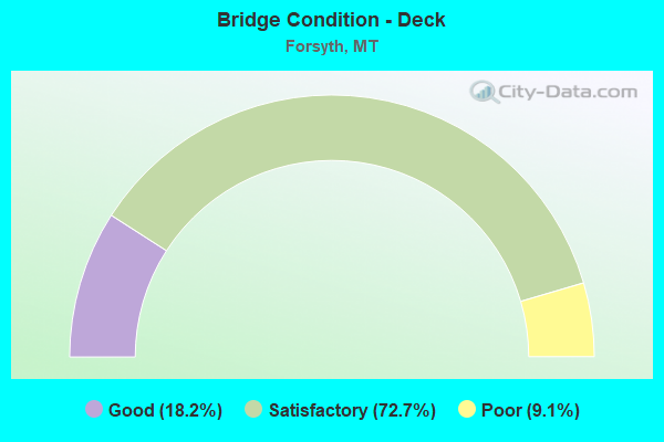
- Bridge Condition - Deck
- 18.2%Good
- 72.7%Satisfactory
- 9.1%Poor
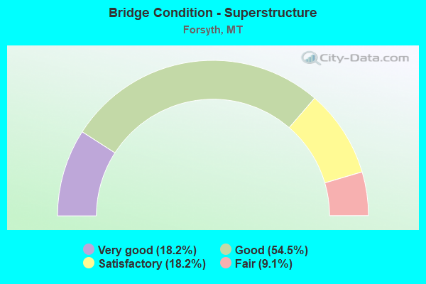
- Bridge Condition - Superstructure
- 18.2%Very good
- 54.5%Good
- 18.2%Satisfactory
- 9.1%Fair
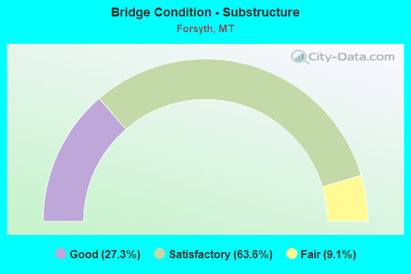
- Bridge Condition - Substructure
- 27.3%Good
- 63.6%Satisfactory
- 9.1%Fair
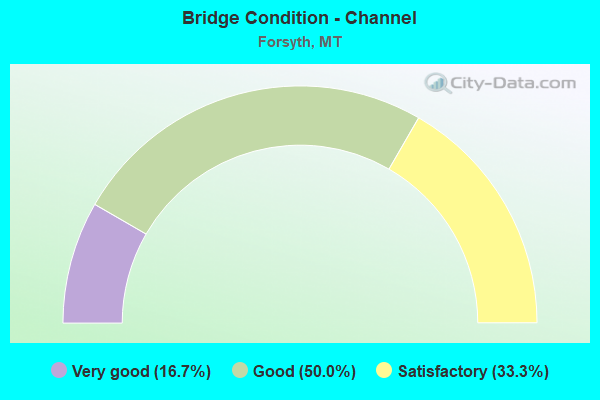
- Bridge Condition - Channel
- 16.7%Very good
- 50.0%Good
- 33.3%Satisfactory
Find on map >> Show street view
Structure Number: I00094092+02621, Location: 2M W FORSYTH (Lat: 46.252653, Lng: -106.720956), Route carried "on" structure: Interstate 94, Year Built: 1967, Status: Open, Structure Length: 6.72m (22.05ft), Average Daily Traffic: 4,328 (year 2020), Truck Traffic: 24%, Average Future Daily Traffic: 4,609 (year 2040), Design Load: HS 20, Features Intersected: SMITH CREEK-SEP CO RD
Minimum Vertical Clearance: 30+ m (98+ ft), Kilometerpoint: 147.841, Lanes on structure: 2, Lanes under structure: 2, Base Highway Network: Yes, Owner: State Highway Agency, Approaching Roadway Width: 11.7m (38.4ft), Material/Design: Prestressed concrete, Design/Construction: Stringer/Multi-beam, Number Of Spans In Main Unit: 4, Length of Maximum Span: 20.1m (65.9ft), Curb-To-Curb Width: 13.1m (43.0ft), Out-to-Out Width: 14.0m (45.9ft)
Condition: Deck: Good, Superstructure: Very good, Substructure: Satisfactory, Channel: Good, Operating Rating: 46.3 metric tons, Method Used To Determine Operating Rating: Load and Resistance Factor (LRFR), Inventory Rating: 24.5 metric tons, Method Used To Determine Inventory Rating: Load and Resistance Factor (LRFR), Structural Evaluation: Equal to present minimum criteria, Deck Geometry: Superior to present desirable criteria, Underclear: Meets minimum limits, Waterway Adequacy: Equal to present desirable criteria, Approach Roadway Alignment: Equal to present minimum criteria, Designated Inspection Frequency: Every 24 months, Inspection Date: October 2020, Deck Structure Type: Concrete Cast-file-Place, Wearing Surface/Protective System: Wearing Surface: Monolithic Concrete
Find on map >> Show street view
Structure Number: I00094092+02622, Location: 2M W FORSYTH (Lat: 46.252933, Lng: -106.720983), Route carried "on" structure: Interstate 94, Year Built: 1972, Status: Open, Structure Length: 6.72m (22.05ft), Average Daily Traffic: 4,328 (year 2020), Truck Traffic: 24%, Average Future Daily Traffic: 4,609 (year 2040), Design Load: HS 20, Features Intersected: SMITH CREEK-SEP CO RD
Minimum Vertical Clearance: 30+ m (98+ ft), Kilometerpoint: 148.671, Lanes on structure: 2, Lanes under structure: 2, Base Highway Network: Yes, Owner: State Highway Agency, Approaching Roadway Width: 11.5m (37.7ft), Material/Design: Prestressed concrete, Design/Construction: Stringer/Multi-beam, Number Of Spans In Main Unit: 4, Length of Maximum Span: 20.3m (66.6ft), Curb or Sidewalk Widths: Left: 0.1m (0.3ft), Right: 0.1m (0.3ft), Curb-To-Curb Width: 12.6m (41.3ft), Out-to-Out Width: 13.5m (44.3ft)
Condition: Deck: Satisfactory, Superstructure: Good, Substructure: Satisfactory, Channel: Good, Operating Rating: 50.8 metric tons, Method Used To Determine Operating Rating: Load and Resistance Factor (LRFR), Inventory Rating: 25.4 metric tons, Method Used To Determine Inventory Rating: Load and Resistance Factor (LRFR), Structural Evaluation: Equal to present minimum criteria, Deck Geometry: Better than present minimum criteria, Underclear: Meets minimum limits, Waterway Adequacy: Equal to present desirable criteria, Approach Roadway Alignment: Equal to present minimum criteria, Designated Inspection Frequency: Every 24 months, Inspection Date: March 2020, Deck Structure Type: Concrete Cast-file-Place, Wearing Surface/Protective System: Wearing Surface: Monolithic Concrete
Find on map >> Show street view
Structure Number: I00094095+02361, Location: EAST FORSYTH (Lat: 46.266925, Lng: -106.665056), Route carried "on" structure: Interstate 94, Year Built: 1977, Status: Open, Structure Length: 6.10m (20.01ft), Average Daily Traffic: 4,328 (year 2020), Truck Traffic: 25%, Average Future Daily Traffic: 4,588 (year 2040), Design Load: HS 20, Features Intersected: INT EAST FORSYTH
Minimum Vertical Clearance: 30+ m (98+ ft), Kilometerpoint: 152.636, Lanes on structure: 2, Lanes under structure: 2, Base Highway Network: Yes, Owner: State Highway Agency, Approaching Roadway Width: 11.6m (38.1ft), Skew: 5 degrees, Material/Design: Prestressed concrete, Design/Construction: Stringer/Multi-beam, Number Of Spans In Main Unit: 3, Length of Maximum Span: 27.7m (90.9ft), Curb or Sidewalk Widths: Left: 0.1m (0.3ft), Right: 0.1m (0.3ft), Curb-To-Curb Width: 12.6m (41.3ft), Out-to-Out Width: 13.5m (44.3ft)
Condition: Deck: Satisfactory, Superstructure: Good, Substructure: Satisfactory, Operating Rating: 48.1 metric tons, Method Used To Determine Operating Rating: Load and Resistance Factor (LRFR), Inventory Rating: 26.3 metric tons, Method Used To Determine Inventory Rating: Load and Resistance Factor (LRFR), Structural Evaluation: Equal to present minimum criteria, Deck Geometry: Better than present minimum criteria, Underclear: Better than present minimum criteria, Approach Roadway Alignment: Equal to present minimum criteria, Designated Inspection Frequency: Every 24 months, Inspection Date: June 2020, Deck Structure Type: Concrete Cast-file-Place, Wearing Surface/Protective System: Wearing Surface: Monolithic Concrete
Find on map >> Show street view
Structure Number: I00094095+02362, Location: EAST FORSYTH (Lat: 46.267131, Lng: -106.665222), Route carried "on" structure: Interstate 94, Year Built: 1977, Status: Open, Structure Length: 5.85m (19.19ft), Average Daily Traffic: 4,393 (year 2020), Truck Traffic: 24%, Average Future Daily Traffic: 4,657 (year 2040), Design Load: HS 20, Features Intersected: INT EAST FORSYTH
Minimum Vertical Clearance: 30+ m (98+ ft), Kilometerpoint: 153.449, Lanes on structure: 2, Lanes under structure: 2, Base Highway Network: Yes, Owner: State Highway Agency, Approaching Roadway Width: 11.6m (38.1ft), Skew: 5 degrees, Material/Design: Prestressed concrete, Design/Construction: Stringer/Multi-beam, Number Of Spans In Main Unit: 3, Length of Maximum Span: 27.9m (91.5ft), Curb or Sidewalk Widths: Left: 0.1m (0.3ft), Right: 0.1m (0.3ft), Curb-To-Curb Width: 12.6m (41.3ft), Out-to-Out Width: 13.5m (44.3ft)
Condition: Deck: Satisfactory, Superstructure: Good, Substructure: Good, Operating Rating: 53.5 metric tons, Method Used To Determine Operating Rating: Load and Resistance Factor (LRFR), Inventory Rating: 33.6 metric tons, Method Used To Determine Inventory Rating: Load and Resistance Factor (LRFR), Structural Evaluation: Better than present minimum criteria, Deck Geometry: Better than present minimum criteria, Underclear: Better than present minimum criteria, Approach Roadway Alignment: Equal to present minimum criteria, Designated Inspection Frequency: Every 48 months, Inspection Date: June 2020, Deck Structure Type: Concrete Cast-file-Place, Wearing Surface/Protective System: Wearing Surface: Monolithic Concrete
Find on map >> Show street view
Structure Number: L44129000+03001, Location: 1M E FORSYTH (Lat: 46.266556, Lng: -106.628194), Route carried "on" structure: ServiceCounty highway 44129, Year Built: 1977, Status: Open, Structure Length: 9.29m (30.48ft), Average Daily Traffic: 100 (year 2022), Truck Traffic: 3%, Average Future Daily Traffic: 100 (year 2037), Design Load: HS 20, Features Intersected: SEP I 94 SCHIFFER RD 013, Facility Carried by Structure: SCHIFFER RD
Minimum Vertical Clearance: 30+ m (98+ ft), Kilometerpoint: 0.063, Lanes on structure: 2, Lanes under structure: 4, Owner: State Highway Agency, Approaching Roadway Width: 8.5m (27.9ft), Skew: 1 degrees, Material/Design: Prestressed concrete, Design/Construction: Stringer/Multi-beam, Number Of Spans In Main Unit: 4, Length of Maximum Span: 32.5m (106.6ft), Curb or Sidewalk Widths: Left: 0.1m (0.3ft), Right: 0.1m (0.3ft), Curb-To-Curb Width: 8.4m (27.6ft), Out-to-Out Width: 9.2m (30.2ft)
Condition: Deck: Satisfactory, Superstructure: Good, Substructure: Satisfactory, Operating Rating: 48.1 metric tons, Method Used To Determine Operating Rating: Load and Resistance Factor (LRFR), Inventory Rating: 23.6 metric tons, Method Used To Determine Inventory Rating: Load and Resistance Factor (LRFR), Structural Evaluation: Equal to present minimum criteria, Deck Geometry: Equal to present minimum criteria, Underclear: Better than present minimum criteria, Approach Roadway Alignment: Meets minimum limits, Designated Inspection Frequency: Every 24 months, Inspection Date: September 2020, Deck Structure Type: Concrete Cast-file-Place, Wearing Surface/Protective System: Wearing Surface: Monolithic Concrete
Find on map >> Show street view
Structure Number: L44311001+01001, Location: 1M W FORSYTH (Lat: 46.253739, Lng: -106.720992), Route carried "on" structure: ServiceState highway 81018, Year Built: 1928, Year Reconstructed: 1950, Status: Open, Structure Length: 2.71m (8.89ft), Average Daily Traffic: 597 (year 2020), Average Future Daily Traffic: 627 (year 2040), Design Load: HS 15, Features Intersected: SMITH CREEK 053, Facility Carried by Structure: OLD HWY 10 E
Minimum Vertical Clearance: 30+ m (98+ ft), Kilometerpoint: 39.722, Lanes on structure: 2, Owner: State Highway Agency, Approaching Roadway Width: 7.3m (24.0ft), Material/Design: Steel, Design/Construction: Stringer/Multi-beam, Number Of Spans In Main Unit: 3, Length of Maximum Span: 8.8m (28.9ft), Curb or Sidewalk Widths: Left: 0.5m (1.6ft), Right: 0.5m (1.6ft), Curb-To-Curb Width: 9.1m (29.9ft), Out-to-Out Width: 10.5m (34.4ft)
Condition: Deck: Poor, Superstructure: Satisfactory, Substructure: Fair, Channel: Satisfactory, Operating Rating: 46.3 metric tons, Method Used To Determine Operating Rating: Load Factor (LF), Inventory Rating: 27.2 metric tons, Method Used To Determine Inventory Rating: Load Factor (LF), Structural Evaluation: Somewhat better than minimum adequacy, Deck Geometry: Equal to present minimum criteria, Waterway Adequacy: Equal to present desirable criteria, Approach Roadway Alignment: Equal to present desirable criteria, Designated Inspection Frequency: Every 24 months, Inspection Date: September 2020, Deck Structure Type: Concrete Cast-file-Place, Wearing Surface/Protective System: Wearing Surface: Bituminous
Find on map >> Show street view
Structure Number: L44311002+06001, Location: 3M W FORSYTH (Lat: 46.258494, Lng: -106.745192), Route carried "on" structure: ServiceState highway 81018, Year Built: 1941, Status: Posted for load, Structure Length: 1.74m (5.71ft), Average Daily Traffic: 487 (year 2020), Average Future Daily Traffic: 511 (year 2040), Design Load: H 15, Features Intersected: DRAINAGE 052, Facility Carried by Structure: OLD HWY 10 E
Minimum Vertical Clearance: 30+ m (98+ ft), Kilometerpoint: 37.773, Lanes on structure: 2, Owner: State Highway Agency, Approaching Roadway Width: 7.6m (24.9ft), Material/Design: Wood or Timber, Design/Construction: Stringer/Multi-beam, Number Of Spans In Main Unit: 3, Length of Maximum Span: 5.8m (19.0ft), Curb or Sidewalk Widths: Left: 0.2m (0.7ft), Right: 0.2m (0.7ft), Curb-To-Curb Width: 9.2m (30.2ft), Out-to-Out Width: 9.8m (32.2ft)
Condition: Deck: Good, Superstructure: Satisfactory, Substructure: Good, Channel: Very good, Operating Rating: 28.1 metric tons, Method Used To Determine Operating Rating: Allowable Stress (AS), Inventory Rating: 16.3 metric tons, Method Used To Determine Inventory Rating: Allowable Stress (AS), Structural Evaluation: Somewhat better than minimum adequacy, Deck Geometry: Equal to present minimum criteria, Waterway Adequacy: Equal to present desirable criteria, Approach Roadway Alignment: Equal to present desirable criteria, Bridge Posting: Required (Relationship of Operating Rating to Maximum Legal Load: 10.0 - 19.9% below), Designated Inspection Frequency: Every 24 months, Inspection Date: August 2020, Deck Structure Type: Wood or Timber, Wearing Surface/Protective System: Wearing Surface: Bituminous
Find on map >> Show street view
Structure Number: P00014011+01551, Location: 10M E TOWNSEND (Lat: 46.324719, Lng: -111.293444), Route carried "on" structure: US 12, Year Built: 2007, Status: Open, Structure Length: 2.28m (7.48ft), Average Daily Traffic: 1,364 (year 2020), Truck Traffic: 10%, Average Future Daily Traffic: 1,459 (year 2040), Design Load: HS 20+Mod, Features Intersected: DEEP CREEK
Minimum Vertical Clearance: 30+ m (98+ ft), Kilometerpoint: 17.879, Lanes on structure: 2, Base Highway Network: Yes, Owner: State Highway Agency, Approaching Roadway Width: 12.0m (39.4ft), Skew: 1 degrees, Material/Design: Prestressed concrete, Design/Construction: Stringer/Multi-beam, Number Of Spans In Main Unit: 1, Length of Maximum Span: 22.0m (72.2ft), Curb-To-Curb Width: 12.0m (39.4ft), Out-to-Out Width: 12.7m (41.7ft)
Condition: Deck: Satisfactory, Superstructure: Good, Substructure: Good, Channel: Good, Operating Rating: 58.1 metric tons, Method Used To Determine Operating Rating: Load and Resistance Factor (LRFR), Inventory Rating: 37.2 metric tons, Method Used To Determine Inventory Rating: Load and Resistance Factor (LRFR), Structural Evaluation: Better than present minimum criteria, Deck Geometry: Equal to present minimum criteria, Waterway Adequacy: Better than present minimum criteria, Approach Roadway Alignment: Better than present minimum criteria, Length Of Structure Improvement: 2.50m (8.20ft), Designated Inspection Frequency: Every 24 months, Inspection Date: October 2021, Bridge Improvement Cost: $72,000, Roadway Improvement Cost: $7,000, Total Project Cost: $79,000, Deck Structure Type: Concrete Cast-file-Place, Wearing Surface/Protective System: Deck Protection: Epoxy Coated Reinforcing
Find on map >> Show street view
Structure Number: P00014270+03311, Location: W EDGE FORSYTH (Lat: 46.264586, Lng: -106.696119), Route carried "on" structure: US 12, Year Built: 1958, Year Reconstructed: 2012, Status: Open, Structure Length: 25.29m (82.97ft), Average Daily Traffic: 680 (year 2020), Truck Traffic: 4%, Average Future Daily Traffic: 714 (year 2040), Design Load: HS 20, Features Intersected: YELLOWSTONE RIVER
Minimum Vertical Clearance: 30+ m (98+ ft), Kilometerpoint: 434.628, Lanes on structure: 2, Base Highway Network: Yes, Owner: State Highway Agency, Approaching Roadway Width: 9.3m (30.5ft), Material/Design: Steel continuous, Design/Construction: Girder and Floorbeam System, Number Of Spans In Main Unit: 4, Number Of Approach Spans: 4, Length of Maximum Span: 55.8m (183.1ft), Curb-To-Curb Width: 8.4m (27.6ft), Out-to-Out Width: 11.2m (36.7ft)
Condition: Deck: Satisfactory, Superstructure: Fair, Substructure: Satisfactory, Channel: Satisfactory, Operating Rating: 27.2 metric tons, Method Used To Determine Operating Rating: Load Factor (LF), Inventory Rating: 16.3 metric tons, Method Used To Determine Inventory Rating: Load Factor (LF), Structural Evaluation: Meets minimum limits, Deck Geometry: Somewhat better than minimum adequacy, Waterway Adequacy: Equal to present desirable criteria, Approach Roadway Alignment: Equal to present desirable criteria, Designated Inspection Frequency: Every 24 months, Critical Feature Inspection Frequency: Every 24 months, Underwater Inspection Frequency: Every 60 months, Inspection Date: June 2021, Critical Feature Inspection Date: June 2021, Underwater Inspection Date: August 2020, Deck Structure Type: Concrete Cast-file-Place
Find on map >> Show street view
Structure Number: P00014270+05031, Location: SW EDGE FORSYTH (Lat: 46.258281, Lng: -106.694317), Route carried "on" structure: US 12, Year Built: 1977, Status: Open, Structure Length: 7.15m (23.46ft), Average Daily Traffic: 1,260 (year 2020), Truck Traffic: 3%, Average Future Daily Traffic: 1,323 (year 2040), Design Load: HS 20, Features Intersected: RR
Minimum Vertical Clearance: 30+ m (98+ ft), Kilometerpoint: 435.346, Lanes on structure: 2, Base Highway Network: Yes, Owner: State Highway Agency, Approaching Roadway Width: 12.0m (39.4ft), Skew: 1 degrees, Material/Design: Prestressed concrete, Design/Construction: Stringer/Multi-beam, Number Of Spans In Main Unit: 3, Length of Maximum Span: 32.5m (106.6ft), Curb or Sidewalk Widths: Left: 0.1m (0.3ft), Right: 0.1m (0.3ft), Curb-To-Curb Width: 13.3m (43.6ft), Out-to-Out Width: 14.1m (46.3ft)
Condition: Deck: Satisfactory, Superstructure: Good, Substructure: Satisfactory, Operating Rating: 48.1 metric tons, Method Used To Determine Operating Rating: Load and Resistance Factor (LRFR), Inventory Rating: 20.9 metric tons, Method Used To Determine Inventory Rating: Load and Resistance Factor (LRFR), Structural Evaluation: Somewhat better than minimum adequacy, Deck Geometry: Better than present minimum criteria, Underclear: High priority of corrective action, Approach Roadway Alignment: Equal to present desirable criteria, Designated Inspection Frequency: Every 24 months, Inspection Date: June 2020, Deck Structure Type: Concrete Cast-file-Place, Wearing Surface/Protective System: Wearing Surface: Monolithic Concrete
Find on map >> Show street view
Structure Number: P00014270+08881, Location: SW EDGE FORSYTH (Lat: 46.256908, Lng: -106.693661), Route carried "on" structure: US 12, Year Built: 1977, Status: Open, Structure Length: 7.78m (25.52ft), Average Daily Traffic: 1,260 (year 2020), Truck Traffic: 3%, Average Future Daily Traffic: 1,323 (year 2040), Design Load: HS 20, Features Intersected: INT WEST FORSYTH I 94
Minimum Vertical Clearance: 30+ m (98+ ft), Kilometerpoint: 435.513, Lanes on structure: 2, Lanes under structure: 4, Base Highway Network: Yes, Owner: State Highway Agency, Approaching Roadway Width: 12.2m (40.0ft), Material/Design: Prestressed concrete, Design/Construction: Stringer/Multi-beam, Number Of Spans In Main Unit: 4, Length of Maximum Span: 26.4m (86.6ft), Curb or Sidewalk Widths: Left: 0.1m (0.3ft), Right: 0.1m (0.3ft), Curb-To-Curb Width: 13.3m (43.6ft), Out-to-Out Width: 14.1m (46.3ft)
Condition: Deck: Satisfactory, Superstructure: Very good, Substructure: Satisfactory, Operating Rating: 54.4 metric tons, Method Used To Determine Operating Rating: Load and Resistance Factor (LRFR), Inventory Rating: 32.7 metric tons, Method Used To Determine Inventory Rating: Load and Resistance Factor (LRFR), Structural Evaluation: Equal to present minimum criteria, Deck Geometry: Better than present minimum criteria, Underclear: Meets minimum limits, Approach Roadway Alignment: Equal to present minimum criteria, Designated Inspection Frequency: Every 48 months, Inspection Date: September 2018, Deck Structure Type: Concrete Cast-file-Place, Wearing Surface/Protective System: Wearing Surface: Monolithic Concrete
Find on map >> Show street view
Structure Number: I00094092+02621, Location: 2M W FORSYTH (Lat: 46.252653, Lng: -106.720956), Route carried "under" structure: ServiceCounty highway 44125, Year Built: 1967, Structure Length: 0. m, Average Daily Traffic: 100 (year 2022), Truck Traffic: 3%, Features Intersected: SMITH CREEK-SEP CO RD, Facility Carried by Structure: I 94
Minimum Vertical Clearance: 6.07m (19.91ft), Kilometerpoint: 0.048, Lanes on structure: 2, Lanes under structure: 2, Material/Design: Prestressed concrete, Design/Construction: Stringer/Multi-beam, Length of Maximum Span: 20.1m (65.9ft)
Find on map >> Show street view
Structure Number: I00094092+02622, Location: 2M W FORSYTH (Lat: 46.252933, Lng: -106.720983), Route carried "under" structure: ServiceCounty highway 44125, Year Built: 1972, Structure Length: 0. m, Average Daily Traffic: 100 (year 2022), Truck Traffic: 3%, Features Intersected: SMITH CREEK-SEP CO RD, Facility Carried by Structure: I 94
Minimum Vertical Clearance: 5.80m (19.03ft), Kilometerpoint: 0.078, Lanes on structure: 2, Lanes under structure: 2, Material/Design: Prestressed concrete, Design/Construction: Stringer/Multi-beam, Length of Maximum Span: 20.3m (66.6ft)
Find on map >> Show street view
Structure Number: I00094095+02361, Location: EAST FORSYTH (Lat: 46.266925, Lng: -106.665056), Route carried "under" structure: State highway 95, Year Built: 1977, Structure Length: 0. m, Average Daily Traffic: 1,574 (year 2020), Truck Traffic: 3%, Features Intersected: INT EAST FORSYTH, Facility Carried by Structure: I 94
Minimum Vertical Clearance: 5.05m (16.57ft), Kilometerpoint: 0.002, Lanes on structure: 2, Lanes under structure: 2, Material/Design: Prestressed concrete, Design/Construction: Stringer/Multi-beam, Length of Maximum Span: 27.7m (90.9ft)
Find on map >> Show street view
Structure Number: I00094095+02362, Location: EAST FORSYTH (Lat: 46.267131, Lng: -106.665222), Route carried "under" structure: State highway 95, Year Built: 1977, Structure Length: 0. m, Average Daily Traffic: 1,574 (year 2020), Truck Traffic: 3%, Features Intersected: INT EAST FORSYTH, Facility Carried by Structure: I 94
Minimum Vertical Clearance: 5.65m (18.54ft), Kilometerpoint: 0.028, Lanes on structure: 2, Lanes under structure: 2, Material/Design: Prestressed concrete, Design/Construction: Stringer/Multi-beam, Length of Maximum Span: 27.9m (91.5ft)
Find on map >> Show street view
Structure Number: L44129000+03001, Location: 1M E FORSYTH (Lat: 46.266556, Lng: -106.628194), Route carried "under" structure: Interstate 94, Year Built: 1977, Structure Length: 0. m, Average Daily Traffic: 4,393 (year 2020), Truck Traffic: 24%, Features Intersected: SEP I 94 SCHIFFER RD 013, Facility Carried by Structure: SCHIFFER RD
Minimum Vertical Clearance: 5.18m (16.99ft), Kilometerpoint: 155.512, Lanes on structure: 2, Lanes under structure: 4, Material/Design: Prestressed concrete, Design/Construction: Stringer/Multi-beam, Length of Maximum Span: 32.5m (106.6ft)
Find on map >> Show street view
Structure Number: P00014270+08881, Location: SW EDGE FORSYTH (Lat: 46.256908, Lng: -106.693661), Route carried "under" structure: Interstate 94, Year Built: 1977, Structure Length: 0. m, Average Daily Traffic: 4,328 (year 2020), Truck Traffic: 24%, Features Intersected: INT WEST FORSYTH I 94, Facility Carried by Structure: US 12
Minimum Vertical Clearance: 5.23m (17.16ft), Kilometerpoint: 150.015, Lanes on structure: 2, Lanes under structure: 4, Material/Design: Prestressed concrete, Design/Construction: Stringer/Multi-beam, Length of Maximum Span: 26.4m (86.6ft)