Bridge Statistics for Franklin Lakes, New Jersey (NJ)
Condition, Traffic, Stress, Structural Evaluation, Project Costs
- National Bridge Inventory (NBI) Statistics
- 38Number of bridges
- 335ft / 102mTotal length
- $3,655,000Total costs
- 1,003,856Total average daily traffic
- 65,379Total average daily truck traffic
- National Bridge Inventory (NBI) Registered Bridges for Franklin Lakes
- No street view available for this location
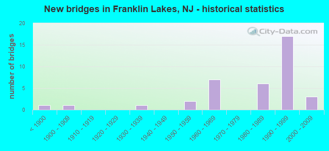
- New bridges - historical statistics
- 1Before 1900
- 11900-1909
- 11930-1939
- 21950-1959
- 71960-1969
- 61980-1989
- 171990-1999
- 32000-2009

- Reconstructed bridges - Historical Statistics
- 11950-1959
- 11960-1969
- 01970-1979
- 41980-1989
- 21990-1999
- 12000-2009


- Bridge Condition - Deck
- 70.6%Good
- 23.5%Satisfactory
- 5.9%Fair

- Bridge Condition - Superstructure
- 5.6%Very good
- 38.9%Good
- 44.4%Satisfactory
- 11.1%Fair

- Bridge Condition - Substructure
- 22.2%Good
- 61.1%Satisfactory
- 16.7%Fair

- Bridge Condition - Channel
- 14.3%Excellent
- 14.3%Very good
- 42.9%Good
- 28.6%Satisfactory

- Bridge Condition - Culverts
- 85.7%Good
- 14.3%Satisfactory
Find on map >> Show street view
Structure Number: 20020A, Location: .10 MI.SOUTH OF RT.208 (Lat: 41.017550, Lng: -74.220000), Route carried "on" structure: County highway 117, Year Built: 2001, Year Reconstructed: 2014, Status: Open, Structure Length: 0.76m (2.49ft), Average Daily Traffic: 8,962 (year 2020), Truck Traffic: 4%, Average Future Daily Traffic: 10,936 (year 2040), Design Load: HS 20, Features Intersected: TRIB OF POND BROOK
Minimum Vertical Clearance: 30+ m (98+ ft), Kilometerpoint: 2.768, Lanes on structure: 2, Owner: County Highway Agency, Approaching Roadway Width: 13.7m (44.9ft), Skew: 1 degrees, Material/Design: Concrete, Design/Construction: Culvert, Number Of Spans In Main Unit: 1, Length of Maximum Span: 6.7m (22.0ft), Curb or Sidewalk Widths: Left: 0.0m, Right: 1.2m (3.9ft)
Condition: Channel: Good, Culverts: Good, Operating Rating: 42.1 metric tons, Method Used To Determine Operating Rating: Assigned ratings based on Load and Resistance Factor Design (LRFD) reported by rating factor (RF) using HL93 loadings, Inventory Rating: 32.4 metric tons, Method Used To Determine Inventory Rating: Assigned ratings based on Load and Resistance Factor Design (LRFD) reported by rating factor (RF) using HL93 loadings, Structural Evaluation: Better than present minimum criteria, Waterway Adequacy: Superior to present desirable criteria, Approach Roadway Alignment: Equal to present minimum criteria, Designated Inspection Frequency: Every 24 months, Inspection Date: April 2020
Find on map >> Show street view
Structure Number: 20020B, Location: .5 MI.WEST OF WYCKOFF AVE (Lat: 41.030619, Lng: -74.176211), Route carried "on" structure: City street S85, Year Built: 1900, Year Reconstructed: 1960, Status: Posted for load, Structure Length: 0.70m (2.30ft), Average Daily Traffic: 8,366 (year 2020), Truck Traffic: 4%, Average Future Daily Traffic: 10,209 (year 2040), Design Load: HS 20+Mod, Features Intersected: HO-HO-KUS BROOK, Facility Carried by Structure: PULIS AVENUE
Minimum Vertical Clearance: 30+ m (98+ ft), Kilometerpoint: 1.143, Lanes on structure: 2, Owner: County Highway Agency, Approaching Roadway Width: 12.2m (40.0ft), Skew: 2 degrees, Material/Design: Concrete, Design/Construction: Arch - Deck, Number Of Spans In Main Unit: 1, Length of Maximum Span: 6.4m (21.0ft), Curb or Sidewalk Widths: Left: 1.1m (3.6ft), Right: 1.2m (3.9ft), Curb-To-Curb Width: 12.3m (40.4ft), Out-to-Out Width: 15.1m (49.5ft)
Condition: Deck: Fair, Superstructure: Fair, Substructure: Fair, Channel: Satisfactory, Operating Rating: 20.9 metric tons, Method Used To Determine Operating Rating: Load Factor (LF), Inventory Rating: 11.8 metric tons, Method Used To Determine Inventory Rating: Load Factor (LF), Structural Evaluation: High priority of replacement, Deck Geometry: Somewhat better than minimum adequacy, Waterway Adequacy: Better than present minimum criteria, Approach Roadway Alignment: Meets minimum limits, Bridge Posting: Required (Relationship of Operating Rating to Maximum Legal Load: 0.1 - 9.9% below), Length Of Structure Improvement: 0.70m (2.30ft), Designated Inspection Frequency: Every 24 months, Other Special Inspection Frequency: Every 12 months, Inspection Date: April 2020, Other Special Inspection Date: April 2021, Bridge Improvement Cost: $497,000, Roadway Improvement Cost: $100,000, Total Project Cost: $1,047,000 ( Estimate for 2020), Deck Structure Type: Concrete Cast-file-Place, Wearing Surface/Protective System: Wearing Surface: Bituminous
Find on map >> Show street view
Structure Number: 20020D, Location: 0.13 mi S. Pulis Avenue (Lat: 41.030419, Lng: -74.180361), Route carried "on" structure: City street , Year Built: 2000, Status: Open, Structure Length: 0.79m (2.59ft), Average Daily Traffic: 1,501 (year 2020), Truck Traffic: 3%, Average Future Daily Traffic: 1,802 (year 2040), Features Intersected: Ho-Ho-Kus Brook, Facility Carried by Structure: Woodside Avenue
Minimum Vertical Clearance: 30+ m (98+ ft), Kilometerpoint: 1.223, Lanes on structure: 2, Owner: Town or Township Highway Agency, Approaching Roadway Width: 7.3m (24.0ft), Material/Design: Concrete, Design/Construction: Arch - Deck, Number Of Spans In Main Unit: 1, Length of Maximum Span: 7.3m (24.0ft), Curb or Sidewalk Widths: Left: 1.8m (5.9ft), Right: 0.5m (1.6ft), Curb-To-Curb Width: 7.3m (24.0ft), Out-to-Out Width: 10.5m (34.4ft)
Condition: Superstructure: Good, Substructure: Good, Channel: Very good, Inventory Rating: 88.0 metric tons, Method Used To Determine Inventory Rating: Load Factor (LF), Structural Evaluation: Better than present minimum criteria, Deck Geometry: Meets minimum limits, Waterway Adequacy: Superior to present desirable criteria, Approach Roadway Alignment: Equal to present minimum criteria, Designated Inspection Frequency: Every 24 months, Inspection Date: April 2020, Wearing Surface/Protective System: Wearing Surface: Bituminous
Find on map >> Show street view
Structure Number: 20033E, Location: 0.23 mi N of CR 101 (Lat: 41.023700, Lng: -74.167500), Route carried "on" structure: County highway 87, Year Built: 1899, Year Reconstructed: 1958, Status: Open, Structure Length: 0.67m (2.20ft), Average Daily Traffic: 11,690 (year 2020), Truck Traffic: 4%, Average Future Daily Traffic: 14,020 (year 2040), Design Load: H 20, Features Intersected: HO-HO-KUS BROOK
Minimum Vertical Clearance: 30+ m (98+ ft), Kilometerpoint: 7.049, Lanes on structure: 2, Base Highway Network: Yes, Owner: County Highway Agency, Approaching Roadway Width: 10.7m (35.1ft), Material/Design: Concrete, Design/Construction: Arch - Deck, Number Of Spans In Main Unit: 1, Length of Maximum Span: 6.1m (20.0ft), Curb or Sidewalk Widths: Left: 1.2m (3.9ft), Right: 1.2m (3.9ft), Curb-To-Curb Width: 12.2m (40.0ft), Out-to-Out Width: 15.1m (49.5ft)
Condition: Deck: Good, Superstructure: Fair, Substructure: Fair, Channel: Good, Operating Rating: 45.4 metric tons, Method Used To Determine Operating Rating: Load Factor (LF), Inventory Rating: 27.2 metric tons, Method Used To Determine Inventory Rating: Load Factor (LF), Structural Evaluation: Somewhat better than minimum adequacy, Deck Geometry: Somewhat better than minimum adequacy, Waterway Adequacy: Superior to present desirable criteria, Approach Roadway Alignment: Better than present minimum criteria, Length Of Structure Improvement: 0.61m (2.00ft), Designated Inspection Frequency: Every 24 months, Inspection Date: March 2020, Bridge Improvement Cost: $84,000, Total Project Cost: $212,000 ( Estimate for 2020), Deck Structure Type: Concrete Cast-file-Place, Wearing Surface/Protective System: Wearing Surface: Bituminous
Find on map >> Show street view
Structure Number: 233159, Location: 2.2 MI SOUTH OF I-287 JCT (Lat: 41.007231, Lng: -74.192319), Route carried "on" structure: State highway 208, Year Built: 1959, Year Reconstructed: 1995, Status: Open, Structure Length: 2.38m (7.81ft), Average Daily Traffic: 46,375 (year 2021), Truck Traffic: 5%, Average Future Daily Traffic: 55,650 (year 2041), Design Load: HS 20, Features Intersected: EWING AVENUE(CO RT 502)
Minimum Vertical Clearance: 30+ m (98+ ft), Kilometerpoint: 12.666, Lanes on structure: 4, Lanes under structure: 2, Base Highway Network: Yes, Owner: State Highway Agency, Approaching Roadway Width: 29.9m (98.1ft), Skew: 32 degrees, Material/Design: Steel, Design/Construction: Stringer/Multi-beam, Number Of Spans In Main Unit: 1, Length of Maximum Span: 22.6m (74.1ft), Curb-To-Curb Width: 29.8m (97.8ft), Out-to-Out Width: 31.8m (104.3ft)
Condition: Deck: Good, Superstructure: Satisfactory, Substructure: Fair, Inventory Rating: 54.4 metric tons, Method Used To Determine Inventory Rating: Load Factor (LF), Structural Evaluation: Somewhat better than minimum adequacy, Deck Geometry: Superior to present desirable criteria, Underclear: Somewhat better than minimum adequacy, Approach Roadway Alignment: Equal to present desirable criteria, Designated Inspection Frequency: Every 24 months, Inspection Date: September 2021, Deck Structure Type: Concrete Cast-file-Place, Wearing Surface/Protective System: Wearing Surface: Latex Concrete, Deck Protection: Epoxy Coated Reinforcing
Find on map >> Show street view
Structure Number: 23316, Location: 5.6 MI N OF CO. 507 JCT (Lat: 41.011339, Lng: -74.202539), Route carried "on" structure: County highway S89, Year Built: 1960, Year Reconstructed: 1995, Status: Open, Structure Length: 3.57m (11.71ft), Average Daily Traffic: 2,650 (year 2021), Truck Traffic: 4%, Average Future Daily Traffic: 3,180 (year 2041), Design Load: H 20, Features Intersected: NJ 208, Facility Carried by Structure: SUMMIT AVENUE
Minimum Vertical Clearance: 30.18m (99.02ft), Kilometerpoint: 1.609, Lanes on structure: 2, Lanes under structure: 6, Owner: State Highway Agency, Approaching Roadway Width: 10.7m (35.1ft), Skew: 1 degrees, Material/Design: Steel, Design/Construction: Stringer/Multi-beam, Number Of Spans In Main Unit: 2, Length of Maximum Span: 16.5m (54.1ft), Curb or Sidewalk Widths: Left: 0.0m, Right: 1.8m (5.9ft), Curb-To-Curb Width: 10.8m (35.4ft), Out-to-Out Width: 13.6m (44.6ft)
Condition: Deck: Good, Superstructure: Good, Substructure: Satisfactory, Operating Rating: 87.1 metric tons, Method Used To Determine Operating Rating: Load Factor (LF), Inventory Rating: 51.7 metric tons, Method Used To Determine Inventory Rating: Load Factor (LF), Structural Evaluation: Equal to present minimum criteria, Deck Geometry: Somewhat better than minimum adequacy, Underclear: High priority of corrective action, Approach Roadway Alignment: Equal to present minimum criteria, Length Of Structure Improvement: 30.48m (100.00ft), Designated Inspection Frequency: Every 24 months, Inspection Date: July 2021, Roadway Improvement Cost: $360,000, Total Project Cost: $476,000 ( Estimate for 2021), Deck Structure Type: Concrete Cast-file-Place, Wearing Surface/Protective System: Wearing Surface: Monolithic Concrete, Deck Protection: Epoxy Coated Reinforcing
Find on map >> Show street view
Structure Number: 233161, Location: 1.3 MI SE OF 208-202 JCT (Lat: 41.018181, Lng: -74.219131), Route carried "on" structure: State highway 208, Year Built: 1961, Year Reconstructed: 1991, Status: Open, Structure Length: 2.04m (6.69ft), Average Daily Traffic: 46,375 (year 2021), Truck Traffic: 5%, Average Future Daily Traffic: 55,650 (year 2041), Design Load: H 20, Features Intersected: COLONIAL ROAD (CR 117)
Minimum Vertical Clearance: 30+ m (98+ ft), Kilometerpoint: 15.208, Lanes on structure: 6, Lanes under structure: 4, Base Highway Network: Yes, Owner: State Highway Agency, Approaching Roadway Width: 33.5m (109.9ft), Skew: 31 degrees, Material/Design: Prestressed concrete, Design/Construction: Stringer/Multi-beam, Number Of Spans In Main Unit: 1, Length of Maximum Span: 18.9m (62.0ft), Curb-To-Curb Width: 33.4m (109.6ft), Out-to-Out Width: 35.3m (115.8ft)
Condition: Deck: Good, Superstructure: Satisfactory, Substructure: Satisfactory, Operating Rating: 44.5 metric tons, Method Used To Determine Operating Rating: Load Factor (LF), Inventory Rating: 26.3 metric tons, Method Used To Determine Inventory Rating: Load Factor (LF), Structural Evaluation: Equal to present minimum criteria, Deck Geometry: Superior to present desirable criteria, Underclear: Meets minimum limits, Approach Roadway Alignment: Equal to present desirable criteria, Designated Inspection Frequency: Every 24 months, Inspection Date: July 2021, Deck Structure Type: Concrete Cast-file-Place, Wearing Surface/Protective System: Wearing Surface: Monolithic Concrete, Deck Protection: Epoxy Coated Reinforcing
Find on map >> Show street view
Structure Number: 233163, Location: 0.25 MI S of 208-287 JCT (Lat: 41.018781, Lng: -74.219700), Route carried "on" structure: State highway 208, Year Built: 1962, Year Reconstructed: 1989, Status: Open, Structure Length: 0.91m (2.99ft), Average Daily Traffic: 45,930 (year 2020), Truck Traffic: 5%, Average Future Daily Traffic: 56,035 (year 2040), Design Load: HS 20, Features Intersected: POND BROOK
Minimum Vertical Clearance: 30.45m (99.90ft), Kilometerpoint: 15.305, Lanes on structure: 6, Base Highway Network: Yes, Owner: State Highway Agency, Approaching Roadway Width: 27.4m (89.9ft), Skew: 30 degrees, Material/Design: Concrete, Design/Construction: Culvert, Number Of Spans In Main Unit: 2, Length of Maximum Span: 4.0m (13.1ft)
Condition: Channel: Good, Culverts: Good, Operating Rating: 89.8 metric tons, Method Used To Determine Operating Rating: Field evaluation and documented engineering judgment, Inventory Rating: 89.8 metric tons, Method Used To Determine Inventory Rating: Field evaluation and documented engineering judgment, Structural Evaluation: Better than present minimum criteria, Waterway Adequacy: Superior to present desirable criteria, Approach Roadway Alignment: Equal to present desirable criteria, Designated Inspection Frequency: Every 24 months, Inspection Date: March 2020
Find on map >> Show street view
Structure Number: 233164, Location: 0.16 Mi. S of I-287 NB Ju (Lat: 41.019681, Lng: -74.221369), Route carried "on" structure: State highway 208, Year Built: 1961, Year Reconstructed: 1992, Status: Open, Structure Length: 5.76m (18.90ft), Average Daily Traffic: 46,375 (year 2021), Truck Traffic: 5%, Average Future Daily Traffic: 55,650 (year 2041), Design Load: HS 20, Features Intersected: DELAWARE & OSTEGO RR
Minimum Vertical Clearance: 5.56m (18.24ft), Kilometerpoint: 15.514, Lanes on structure: 4, Base Highway Network: Yes, Owner: State Highway Agency, Approaching Roadway Width: 27.7m (90.9ft), Skew: 34 degrees, Material/Design: Steel, Design/Construction: Stringer/Multi-beam, Number Of Spans In Main Unit: 3, Length of Maximum Span: 19.2m (63.0ft), Curb or Sidewalk Widths: Left: 1.5m (4.9ft), Right: 0.0m, Curb-To-Curb Width: 27.1m (88.9ft), Out-to-Out Width: 33.8m (110.9ft)
Condition: Deck: Good, Superstructure: Satisfactory, Substructure: Satisfactory, Operating Rating: 52.6 metric tons, Method Used To Determine Operating Rating: Load Factor (LF), Inventory Rating: 31.8 metric tons, Method Used To Determine Inventory Rating: Load Factor (LF), Structural Evaluation: Equal to present minimum criteria, Deck Geometry: Superior to present desirable criteria, Underclear: Somewhat better than minimum adequacy, Approach Roadway Alignment: Equal to present desirable criteria, Designated Inspection Frequency: Every 24 months, Inspection Date: September 2021, Deck Structure Type: Concrete Cast-file-Place, Wearing Surface/Protective System: Wearing Surface: Latex Concrete
Find on map >> Show street view
Structure Number: 233165, Location: .06 MI S OF 208 & 287 JCT (Lat: 41.020450, Lng: -74.222181), Route carried "on" structure: State highway 208, Year Built: 1961, Year Reconstructed: 1989, Status: Open, Structure Length: 1.10m (3.61ft), Average Daily Traffic: 45,930 (year 2020), Truck Traffic: 5%, Average Future Daily Traffic: 56,035 (year 2040), Design Load: HS 20, Features Intersected: POND BROOK
Minimum Vertical Clearance: 30.45m (99.90ft), Kilometerpoint: 15.562, Lanes on structure: 4, Base Highway Network: Yes, Owner: State Highway Agency, Approaching Roadway Width: 22.6m (74.1ft), Skew: 33 degrees, Material/Design: Concrete, Design/Construction: Culvert, Number Of Spans In Main Unit: 2, Length of Maximum Span: 4.3m (14.1ft)
Condition: Channel: Good, Culverts: Good, Operating Rating: 89.8 metric tons, Method Used To Determine Operating Rating: Field evaluation and documented engineering judgment, Inventory Rating: 89.8 metric tons, Method Used To Determine Inventory Rating: Field evaluation and documented engineering judgment, Structural Evaluation: Better than present minimum criteria, Waterway Adequacy: Superior to present desirable criteria, Approach Roadway Alignment: Better than present minimum criteria, Designated Inspection Frequency: Every 24 months, Inspection Date: March 2020
Find on map >> Show street view
Structure Number: 233169, Location: 0.31 MI. N. COLONIAL RD. (Lat: 41.021669, Lng: -74.223331), Route carried "on" structure: State highway 208, Year Built: 1991, Status: Open, Structure Length: 14.63m (48.00ft), Average Daily Traffic: 31,226 (year 2021), Truck Traffic: 5%, Average Future Daily Traffic: 41,530 (year 2041), Design Load: HS 20+Mod, Features Intersected: I 287
Minimum Vertical Clearance: 30+ m (98+ ft), Kilometerpoint: 15.707, Lanes on structure: 2, Lanes under structure: 4, Base Highway Network: Yes, Owner: State Highway Agency, Approaching Roadway Width: 12.5m (41.0ft), Material/Design: Steel continuous, Design/Construction: Stringer/Multi-beam, Number Of Spans In Main Unit: 2, Number Of Approach Spans: 2, Length of Maximum Span: 42.1m (138.1ft), Curb-To-Curb Width: 13.1m (43.0ft), Out-to-Out Width: 14.2m (46.6ft)
Condition: Deck: Good, Superstructure: Satisfactory, Substructure: Satisfactory, Operating Rating: 47.2 metric tons, Method Used To Determine Operating Rating: Load Factor (LF), Inventory Rating: 28.1 metric tons, Method Used To Determine Inventory Rating: Load Factor (LF), Structural Evaluation: Equal to present minimum criteria, Deck Geometry: Superior to present desirable criteria, Underclear: Somewhat better than minimum adequacy, Approach Roadway Alignment: Better than present minimum criteria, Designated Inspection Frequency: Every 24 months, Critical Feature Inspection Frequency: Every 24 months, Inspection Date: July 2021, Critical Feature Inspection Date: July 2021, Deck Structure Type: Concrete Cast-file-Place, Wearing Surface/Protective System: Wearing Surface: Latex Concrete, Deck Protection: Epoxy Coated Reinforcing
Find on map >> Show street view
Structure Number: 233411, Location: 2.1 MI S OF ROUTE 202 JCT (Lat: 41.013869, Lng: -74.208281), Route carried "on" structure: Ramp Other road , Year Built: 1986, Status: Open, Structure Length: 4.39m (14.40ft), Average Daily Traffic: 825 (year 2021), Truck Traffic: 1%, Average Future Daily Traffic: 1,020 (year 2041), Design Load: HS 20+Mod, Features Intersected: NJ ROUTE 208, Facility Carried by Structure: CORP ENTRANCE BR.
Minimum Vertical Clearance: 30+ m (98+ ft), Kilometerpoint: 0.000, Lanes on structure: 1, Lanes under structure: 7, Owner: Private, Approaching Roadway Width: 5.5m (18.0ft), Material/Design: Steel, Design/Construction: Girder and Floorbeam System, Number Of Spans In Main Unit: 1, Length of Maximum Span: 43.3m (142.1ft), Curb-To-Curb Width: 5.5m (18.0ft), Out-to-Out Width: 6.9m (22.6ft)
Condition: Deck: Good, Superstructure: Satisfactory, Substructure: Good, Operating Rating: 89.8 metric tons, Method Used To Determine Operating Rating: Load and Resistance Factor (LRFR), Inventory Rating: 67.1 metric tons, Method Used To Determine Inventory Rating: Load and Resistance Factor (LRFR), Structural Evaluation: Equal to present minimum criteria, Deck Geometry: Meets minimum limits, Underclear: Equal to present minimum criteria, Approach Roadway Alignment: Equal to present desirable criteria, Designated Inspection Frequency: Every 24 months, Critical Feature Inspection Frequency: Every 24 months, Inspection Date: May 2021, Critical Feature Inspection Date: May 2021, Deck Structure Type: Concrete Cast-file-Place, Wearing Surface/Protective System: Wearing Surface: Monolithic Concrete, Deck Protection: Epoxy Coated Reinforcing
Find on map >> Show street view
Structure Number: 233412, Location: 1.7 MI S OF ROUTE 202 JCT (Lat: 41.016061, Lng: -74.213589), Route carried "on" structure: Ramp Other road , Year Built: 1986, Status: Open, Structure Length: 4.39m (14.40ft), Average Daily Traffic: 825 (year 2021), Truck Traffic: 1%, Average Future Daily Traffic: 1,007 (year 2041), Design Load: HS 20+Mod, Features Intersected: NJ ROUTE 208, Facility Carried by Structure: CORP. EXIT BRIDGE
Minimum Vertical Clearance: 30+ m (98+ ft), Kilometerpoint: 0.000, Lanes on structure: 1, Lanes under structure: 7, Owner: Private, Approaching Roadway Width: 5.5m (18.0ft), Material/Design: Steel, Design/Construction: Girder and Floorbeam System, Number Of Spans In Main Unit: 1, Length of Maximum Span: 43.3m (142.1ft), Curb-To-Curb Width: 5.5m (18.0ft), Out-to-Out Width: 6.9m (22.6ft)
Condition: Deck: Good, Superstructure: Satisfactory, Substructure: Good, Operating Rating: 89.8 metric tons, Method Used To Determine Operating Rating: Load and Resistance Factor (LRFR), Inventory Rating: 67.1 metric tons, Method Used To Determine Inventory Rating: Load and Resistance Factor (LRFR), Structural Evaluation: Equal to present minimum criteria, Deck Geometry: Meets minimum limits, Underclear: Meets minimum limits, Approach Roadway Alignment: Equal to present desirable criteria, Designated Inspection Frequency: Every 24 months, Critical Feature Inspection Frequency: Every 24 months, Inspection Date: May 2021, Critical Feature Inspection Date: May 2021, Deck Structure Type: Concrete Cast-file-Place, Wearing Surface/Protective System: Wearing Surface: Monolithic Concrete, Deck Protection: Epoxy Coated Reinforcing
Find on map >> Show street view
Structure Number: 235156, Location: 1.9 M. N. OF RT 208 JCT (Lat: 41.034069, Lng: -74.194300), Route carried "on" structure: Interstate 287, Year Built: 1991, Status: Open, Structure Length: 3.51m (11.52ft), Average Daily Traffic: 31,066 (year 2021), Truck Traffic: 9%, Average Future Daily Traffic: 37,280 (year 2041), Design Load: HS 20+Mod, Features Intersected: BRIDLE WAY
Minimum Vertical Clearance: 30+ m (98+ ft), Kilometerpoint: 99.297, Lanes on structure: 2, Lanes under structure: 2, Base Highway Network: Yes, Owner: State Highway Agency, Approaching Roadway Width: 13.1m (43.0ft), Skew: 1 degrees, Material/Design: Prestressed concrete, Design/Construction: Stringer/Multi-beam, Number Of Spans In Main Unit: 1, Length of Maximum Span: 33.2m (108.9ft), Curb-To-Curb Width: 13.1m (43.0ft), Out-to-Out Width: 14.2m (46.6ft)
Condition: Deck: Good, Superstructure: Good, Substructure: Satisfactory, Operating Rating: 89.8 metric tons, Method Used To Determine Operating Rating: Load Factor (LF), Inventory Rating: 49.9 metric tons, Method Used To Determine Inventory Rating: Load Factor (LF), Structural Evaluation: Equal to present minimum criteria, Deck Geometry: Superior to present desirable criteria, Underclear: Better than present minimum criteria, Approach Roadway Alignment: Equal to present desirable criteria, Designated Inspection Frequency: Every 24 months, Inspection Date: March 2021, Deck Structure Type: Concrete Cast-file-Place, Wearing Surface/Protective System: Wearing Surface: Latex Concrete, Deck Protection: Epoxy Coated Reinforcing
Find on map >> Show street view
Structure Number: 235157, Location: 1.9 MI N OF RT 208 JCT (Lat: 41.033669, Lng: -74.194111), Route carried "on" structure: Interstate 287, Year Built: 1991, Status: Open, Structure Length: 3.47m (11.38ft), Average Daily Traffic: 31,066 (year 2021), Truck Traffic: 9%, Average Future Daily Traffic: 37,280 (year 2041), Design Load: HS 20+Mod, Features Intersected: BRIDLE WAY
Minimum Vertical Clearance: 30+ m (98+ ft), Kilometerpoint: 99.297, Lanes on structure: 2, Lanes under structure: 2, Base Highway Network: Yes, Owner: State Highway Agency, Approaching Roadway Width: 13.1m (43.0ft), Material/Design: Prestressed concrete, Design/Construction: Stringer/Multi-beam, Number Of Spans In Main Unit: 1, Length of Maximum Span: 33.2m (108.9ft), Curb-To-Curb Width: 13.1m (43.0ft), Out-to-Out Width: 14.2m (46.6ft)
Condition: Deck: Satisfactory, Superstructure: Very good, Substructure: Satisfactory, Operating Rating: 89.8 metric tons, Method Used To Determine Operating Rating: Load Factor (LF), Inventory Rating: 50.8 metric tons, Method Used To Determine Inventory Rating: Load Factor (LF), Structural Evaluation: Equal to present minimum criteria, Deck Geometry: Superior to present desirable criteria, Underclear: Superior to present desirable criteria, Approach Roadway Alignment: Equal to present desirable criteria, Designated Inspection Frequency: Every 24 months, Inspection Date: March 2021, Deck Structure Type: Concrete Cast-file-Place, Wearing Surface/Protective System: Wearing Surface: Latex Concrete, Deck Protection: Epoxy Coated Reinforcing
Find on map >> Show street view
Structure Number: 235158, Location: 3.0 MILES NORTH OF NJ208 (Lat: 41.038350, Lng: -74.192950), Route carried "on" structure: City street , Year Built: 1991, Status: Open, Structure Length: 8.05m (26.41ft), Average Daily Traffic: 170 (year 2021), Truck Traffic: 1%, Average Future Daily Traffic: 205 (year 2041), Design Load: HS 20, Features Intersected: I-287, Facility Carried by Structure: PHELPS ROAD
Minimum Vertical Clearance: 30+ m (98+ ft), Kilometerpoint: 0.000, Lanes on structure: 2, Lanes under structure: 4, Owner: State Highway Agency, Approaching Roadway Width: 9.4m (30.8ft), Skew: 3 degrees, Material/Design: Steel continuous, Design/Construction: Stringer/Multi-beam, Number Of Spans In Main Unit: 2, Length of Maximum Span: 45.1m (148.0ft), Curb or Sidewalk Widths: Left: 0.0m, Right: 1.8m (5.9ft), Curb-To-Curb Width: 9.4m (30.8ft), Out-to-Out Width: 12.1m (39.7ft)
Condition: Deck: Good, Superstructure: Good, Substructure: Satisfactory, Inventory Rating: 80.7 metric tons, Method Used To Determine Inventory Rating: Load Factor (LF), Structural Evaluation: Equal to present minimum criteria, Deck Geometry: Equal to present minimum criteria, Underclear: Equal to present minimum criteria, Approach Roadway Alignment: Equal to present minimum criteria, Designated Inspection Frequency: Every 24 months, Inspection Date: September 2021, Deck Structure Type: Concrete Cast-file-Place, Wearing Surface/Protective System: Wearing Surface: Monolithic Concrete, Deck Protection: Epoxy Coated Reinforcing
Find on map >> Show street view
Structure Number: 235165, Location: 1.MI.NO.OF RAMAPO VALY.RD (Lat: 41.019439, Lng: -74.220450), Route carried "on" structure: Ramp Interstate 287, Year Built: 1991, Status: Open, Structure Length: 5.85m (19.19ft), Average Daily Traffic: 15,783 (year 2021), Truck Traffic: 9%, Average Future Daily Traffic: 18,939 (year 2023), Design Load: HS 20+Mod, Features Intersected: NYSW RR & POND BROOK
Minimum Vertical Clearance: 30+ m (98+ ft), Kilometerpoint: 96.464, Lanes on structure: 1, Owner: State Highway Agency, Approaching Roadway Width: 7.8m (25.6ft), Skew: 4 degrees, Material/Design: Steel continuous, Design/Construction: Stringer/Multi-beam, Number Of Spans In Main Unit: 3, Length of Maximum Span: 21.9m (71.9ft), Curb-To-Curb Width: 7.8m (25.6ft), Out-to-Out Width: 8.8m (28.9ft)
Condition: Deck: Good, Superstructure: Good, Substructure: Satisfactory, Channel: Excellent, Operating Rating: 88.0 metric tons, Method Used To Determine Operating Rating: Load Factor (LF), Inventory Rating: 52.6 metric tons, Method Used To Determine Inventory Rating: Load Factor (LF), Structural Evaluation: Equal to present minimum criteria, Deck Geometry: Better than present minimum criteria, Underclear: Equal to present minimum criteria, Waterway Adequacy: Superior to present desirable criteria, Approach Roadway Alignment: Equal to present minimum criteria, Designated Inspection Frequency: Every 24 months, Inspection Date: April 2021, Deck Structure Type: Concrete Cast-file-Place, Wearing Surface/Protective System: Wearing Surface: Latex Concrete, Deck Protection: Epoxy Coated Reinforcing
Find on map >> Show street view
Structure Number: 235166, Location: AT I-287 & NJ 208 JCT (Lat: 41.019250, Lng: -74.221450), Route carried "on" structure: Ramp Interstate 287, Year Built: 1993, Status: Open, Structure Length: 19.84m (65.09ft), Average Daily Traffic: 2,871 (year 2021), Truck Traffic: 9%, Average Future Daily Traffic: 3,445 (year 2041), Design Load: HS 20+Mod, Features Intersected: I-287,NJ 208,RR& POND BK
Minimum Vertical Clearance: 30+ m (98+ ft), Kilometerpoint: 96.464, Lanes on structure: 1, Lanes under structure: 8, Owner: State Highway Agency, Approaching Roadway Width: 8.7m (28.5ft), Skew: 9 degrees, Material/Design: Steel continuous, Design/Construction: Stringer/Multi-beam, Number Of Spans In Main Unit: 6, Length of Maximum Span: 39.6m (129.9ft), Curb-To-Curb Width: 8.7m (28.5ft), Out-to-Out Width: 9.8m (32.2ft)
Condition: Deck: Good, Superstructure: Good, Substructure: Good, Channel: Excellent, Operating Rating: 57.2 metric tons, Method Used To Determine Operating Rating: Load Factor (LF), Inventory Rating: 33.6 metric tons, Method Used To Determine Inventory Rating: Load Factor (LF), Structural Evaluation: Better than present minimum criteria, Deck Geometry: Superior to present desirable criteria, Underclear: Meets minimum limits, Waterway Adequacy: Superior to present desirable criteria, Approach Roadway Alignment: Equal to present minimum criteria, Designated Inspection Frequency: Every 24 months, Inspection Date: April 2021, Deck Structure Type: Concrete Cast-file-Place, Wearing Surface/Protective System: Wearing Surface: Latex Concrete, Deck Protection: Epoxy Coated Reinforcing
Find on map >> Show street view
Structure Number: 23517, Location: 0.5 mile north of NJ 208 (Lat: 41.020911, Lng: -74.214350), Route carried "on" structure: Interstate 287, Year Built: 1989, Status: Open, Structure Length: 0.67m (2.20ft), Average Daily Traffic: 62,100 (year 2021), Truck Traffic: 9%, Average Future Daily Traffic: 74,500 (year 2041), Design Load: HS 20+Mod, Features Intersected: POND BROOK
Minimum Vertical Clearance: 30+ m (98+ ft), Kilometerpoint: 97.043, Lanes on structure: 5, Base Highway Network: Yes, Owner: State Highway Agency, Approaching Roadway Width: 30.5m (100.1ft), Skew: 31 degrees, Material/Design: Concrete continuous, Design/Construction: Culvert, Number Of Spans In Main Unit: 2, Length of Maximum Span: 3.0m (9.8ft)
Condition: Channel: Satisfactory, Culverts: Satisfactory, Structural Evaluation: Equal to present minimum criteria, Waterway Adequacy: Superior to present desirable criteria, Approach Roadway Alignment: Equal to present desirable criteria, Designated Inspection Frequency: Every 24 months, Inspection Date: March 2021
Find on map >> Show street view
Structure Number: 235176, Location: 0.94 MI N OF RT 202 INT (Lat: 41.018269, Lng: -74.220289), Route carried "on" structure: Ramp Interstate 287, Year Built: 1993, Status: Open, Structure Length: 11.49m (37.70ft), Average Daily Traffic: 4,280 (year 2021), Truck Traffic: 9%, Average Future Daily Traffic: 5,137 (year 2041), Design Load: HS 20+Mod, Features Intersected: COLNIAL RD & POND BR
Minimum Vertical Clearance: 30+ m (98+ ft), Kilometerpoint: 97.043, Lanes on structure: 1, Lanes under structure: 4, Owner: State Highway Agency, Approaching Roadway Width: 7.3m (24.0ft), Material/Design: Steel continuous, Design/Construction: Stringer/Multi-beam, Number Of Spans In Main Unit: 4, Length of Maximum Span: 33.2m (108.9ft), Curb-To-Curb Width: 7.3m (24.0ft), Out-to-Out Width: 8.4m (27.6ft)
Condition: Deck: Satisfactory, Superstructure: Satisfactory, Substructure: Satisfactory, Channel: Very good, Operating Rating: 81.6 metric tons, Method Used To Determine Operating Rating: Load Factor (LF), Inventory Rating: 49.0 metric tons, Method Used To Determine Inventory Rating: Load Factor (LF), Structural Evaluation: Equal to present minimum criteria, Deck Geometry: Better than present minimum criteria, Underclear: Meets minimum limits, Waterway Adequacy: Superior to present desirable criteria, Approach Roadway Alignment: Equal to present minimum criteria, Designated Inspection Frequency: Every 24 months, Inspection Date: March 2021, Deck Structure Type: Concrete Cast-file-Place, Wearing Surface/Protective System: Wearing Surface: Latex Concrete, Deck Protection: Epoxy Coated Reinforcing
Find on map >> Show street view
Structure Number: 235177, Location: 0.81 MI N OF NJ 208 JCT (Lat: 41.023350, Lng: -74.209231), Route carried "on" structure: Interstate 287, Year Built: 1993, Status: Open, Structure Length: 3.57m (11.71ft), Average Daily Traffic: 62,133 (year 2021), Truck Traffic: 9%, Average Future Daily Traffic: 74,560 (year 2041), Design Load: HS 20+Mod, Features Intersected: FRANKLIN AVENUE (CR 84)
Minimum Vertical Clearance: 30+ m (98+ ft), Kilometerpoint: 97.558, Lanes on structure: 4, Lanes under structure: 2, Base Highway Network: Yes, Owner: State Highway Agency, Approaching Roadway Width: 14.3m (46.9ft), Skew: 30 degrees, Material/Design: Prestressed concrete, Design/Construction: Stringer/Multi-beam, Number Of Spans In Main Unit: 1, Length of Maximum Span: 34.1m (111.9ft), Curb-To-Curb Width: 28.5m (93.5ft), Out-to-Out Width: 30.3m (99.4ft)
Condition: Deck: Satisfactory, Superstructure: Good, Substructure: Satisfactory, Operating Rating: 71.7 metric tons, Method Used To Determine Operating Rating: Load Factor (LF), Inventory Rating: 36.3 metric tons, Method Used To Determine Inventory Rating: Load Factor (LF), Structural Evaluation: Equal to present minimum criteria, Deck Geometry: Superior to present desirable criteria, Underclear: Equal to present minimum criteria, Approach Roadway Alignment: Equal to present desirable criteria, Designated Inspection Frequency: Every 24 months, Inspection Date: April 2021, Deck Structure Type: Concrete Cast-file-Place, Wearing Surface/Protective System: Wearing Surface: Latex Concrete, Deck Protection: Epoxy Coated Reinforcing
Find on map >> Show street view
Structure Number: 2C2003, Location: 0.14 Mi. W. of C.R. 89 (Lat: 40.992881, Lng: -74.215689), Route carried "on" structure: County highway 502, Year Built: 1931, Status: Open, Structure Length: 1.07m (3.51ft), Average Daily Traffic: 9,307 (year 2020), Truck Traffic: 4%, Average Future Daily Traffic: 11,169 (year 2040), Features Intersected: Pond Brook, Facility Carried by Structure: Franklin Lakes Roa
Minimum Vertical Clearance: 30+ m (98+ ft), Kilometerpoint: 8.111, Lanes on structure: 2, Owner: County Highway Agency, Approaching Roadway Width: 10.7m (35.1ft), Skew: 7 degrees, Material/Design: Concrete, Design/Construction: Slab, Number Of Spans In Main Unit: 1, Length of Maximum Span: 9.4m (30.8ft), Curb or Sidewalk Widths: Left: 1.1m (3.6ft), Right: 2.4m (7.9ft), Curb-To-Curb Width: 10.7m (35.1ft), Out-to-Out Width: 15.2m (49.9ft)
Condition: Deck: Satisfactory, Superstructure: Satisfactory, Substructure: Satisfactory, Channel: Satisfactory, Operating Rating: 22.7 metric tons, Method Used To Determine Operating Rating: Load Factor (LF), Inventory Rating: 13.6 metric tons, Method Used To Determine Inventory Rating: Load Factor (LF), Structural Evaluation: High priority of replacement, Deck Geometry: Meets minimum limits, Waterway Adequacy: Better than present minimum criteria, Approach Roadway Alignment: Better than present minimum criteria, Length Of Structure Improvement: 1.83m (6.00ft), Designated Inspection Frequency: Every 24 months, Inspection Date: April 2020, Bridge Improvement Cost: $1,220,000, Roadway Improvement Cost: $134,000, Total Project Cost: $1,920,000 ( Estimate for 2020), Deck Structure Type: Concrete Cast-file-Place, Wearing Surface/Protective System: Wearing Surface: Monolithic Concrete
Find on map >> Show street view
Structure Number: 2C3312, Location: 0.21 Mi west of Wyckoff A (Lat: 41.029531, Lng: -74.172581), Route carried "on" structure: County highway S85, Year Built: 2005, Status: Open, Structure Length: 0.79m (2.59ft), Average Daily Traffic: 8,366 (year 2020), Truck Traffic: 4%, Average Future Daily Traffic: 10,040 (year 2040), Design Load: HS 25 or greater, Features Intersected: Ho-Ho-Kus Brook, Facility Carried by Structure: Pulis Avenue
Minimum Vertical Clearance: 30+ m (98+ ft), Kilometerpoint: 1.497, Lanes on structure: 2, Owner: County Highway Agency, Approaching Roadway Width: 12.2m (40.0ft), Material/Design: Concrete, Design/Construction: Culvert, Number Of Spans In Main Unit: 2, Length of Maximum Span: 3.7m (12.1ft)
Condition: Channel: Good, Culverts: Good, Inventory Rating: 55.3 metric tons, Method Used To Determine Inventory Rating: Load Factor (LF), Structural Evaluation: Better than present minimum criteria, Waterway Adequacy: Better than present minimum criteria, Approach Roadway Alignment: Better than present minimum criteria, Designated Inspection Frequency: Every 24 months, Inspection Date: May 2020
Find on map >> Show street view
Structure Number: 2M3319, Location: 50 ft E. of Babbit Br. Dr (Lat: 41.030989, Lng: -74.171039), Route carried "on" structure: City street , Year Built: 1990, Status: Open, Structure Length: 0.67m (2.20ft), Average Daily Traffic: 110 (year 2020), Truck Traffic: 1%, Average Future Daily Traffic: 132 (year 2040), Design Load: HS 20, Features Intersected: Ho-Ho-Kus Brook Trib., Facility Carried by Structure: Hutton Drive
Minimum Vertical Clearance: 30+ m (98+ ft), Kilometerpoint: 0.000, Lanes on structure: 2, Owner: City or Municipal Highway Agency, Approaching Roadway Width: 9.1m (29.9ft), Material/Design: Concrete, Design/Construction: Culvert, Number Of Spans In Main Unit: 2, Length of Maximum Span: 3.0m (9.8ft)
Condition: Channel: Good, Culverts: Good, Operating Rating: 54.4 metric tons, Method Used To Determine Operating Rating: Field evaluation and documented engineering judgment, Inventory Rating: 32.7 metric tons, Method Used To Determine Inventory Rating: Field evaluation and documented engineering judgment, Structural Evaluation: Better than present minimum criteria, Waterway Adequacy: Equal to present minimum criteria, Approach Roadway Alignment: Better than present minimum criteria, Designated Inspection Frequency: Every 24 months, Inspection Date: May 2020
Find on map >> Show street view
Structure Number: 2M3323, Location: 500 ft W. of Campgaw Rd. (Lat: 41.038569, Lng: -74.187931), Route carried "on" structure: City street , Year Built: 1985, Status: Open, Structure Length: 0.88m (2.89ft), Average Daily Traffic: 110 (year 2020), Truck Traffic: 1%, Average Future Daily Traffic: 132 (year 2040), Design Load: HS 20, Features Intersected: Ho-Ho-Kus Brook, Facility Carried by Structure: Victoria Lane
Minimum Vertical Clearance: 30.45m (99.90ft), Kilometerpoint: 0.000, Lanes on structure: 2, Owner: City or Municipal Highway Agency, Approaching Roadway Width: 9.1m (29.9ft), Skew: 1 degrees, Material/Design: Concrete, Design/Construction: Culvert, Number Of Spans In Main Unit: 2, Length of Maximum Span: 4.0m (13.1ft), Curb or Sidewalk Widths: Left: 1.5m (4.9ft), Right: 1.5m (4.9ft), Curb-To-Curb Width: 9.1m (29.9ft), Out-to-Out Width: 15.2m (49.9ft)
Condition: Channel: Satisfactory, Culverts: Good, Operating Rating: 54.4 metric tons, Method Used To Determine Operating Rating: Field evaluation and documented engineering judgment, Inventory Rating: 32.7 metric tons, Method Used To Determine Inventory Rating: Field evaluation and documented engineering judgment, Structural Evaluation: Better than present minimum criteria, Deck Geometry: Equal to present minimum criteria, Waterway Adequacy: Superior to present desirable criteria, Approach Roadway Alignment: Equal to present minimum criteria, Designated Inspection Frequency: Every 24 months, Inspection Date: May 2020, Wearing Surface/Protective System: Wearing Surface: Bituminous
Find on map >> Show street view
Structure Number: 233159, Location: 2.2 MI SOUTH OF I-287 JCT (Lat: 41.007231, Lng: -74.192319), Route carried "under" structure: County highway 502, Year Built: 1959, Structure Length: 0. m, Average Daily Traffic: 12,855 (year 2021), Truck Traffic: 4%, Features Intersected: EWING AVENUE(CO RT 502), Facility Carried by Structure: NJ 208
Minimum Vertical Clearance: 4.50m (14.76ft), Kilometerpoint: 11.137, Lanes on structure: 4, Lanes under structure: 2, Material/Design: Steel, Design/Construction: Stringer/Multi-beam, Length of Maximum Span: 22.6m (74.1ft)
Find on map >> Show street view
Structure Number: 23316, Location: 5.6 MI N OF CO. 507 JCT (Lat: 41.011339, Lng: -74.202539), Route carried "under" structure: State highway 208, Year Built: 1960, Structure Length: 0. m, Average Daily Traffic: 46,375 (year 2021), Truck Traffic: 5%, Features Intersected: NJ 208, Facility Carried by Structure: SUMMIT AVENUE
Minimum Vertical Clearance: 4.88m (16.01ft), Kilometerpoint: 13.647, Lanes on structure: 2, Lanes under structure: 6, Material/Design: Steel, Design/Construction: Stringer/Multi-beam, Length of Maximum Span: 16.5m (54.1ft)
Find on map >> Show street view
Structure Number: 233161, Location: 1.3 MI SE OF 208-202 JCT (Lat: 41.018181, Lng: -74.219131), Route carried "under" structure: City street 117, Year Built: 1961, Structure Length: 0. m, Average Daily Traffic: 8,990 (year 2021), Truck Traffic: 4%, Features Intersected: COLONIAL ROAD (CR 117), Facility Carried by Structure: NJ 208
Minimum Vertical Clearance: 4.47m (14.67ft), Kilometerpoint: 2.913, Lanes on structure: 6, Lanes under structure: 4, Material/Design: Prestressed concrete, Design/Construction: Stringer/Multi-beam, Length of Maximum Span: 18.9m (62.0ft)
Find on map >> Show street view
Structure Number: 233169, Location: 0.31 MI. N. COLONIAL RD. (Lat: 41.021669, Lng: -74.223331), Route carried "under" structure: Interstate 287, Year Built: 1991, Structure Length: 0. m, Average Daily Traffic: 60,100 (year 2021), Truck Traffic: 9%, Features Intersected: I 287, Facility Carried by Structure: NJ 208 NB
Minimum Vertical Clearance: 5.46m (17.91ft), Kilometerpoint: 96.239, Lanes on structure: 2, Lanes under structure: 4, Material/Design: Steel continuous, Design/Construction: Stringer/Multi-beam, Length of Maximum Span: 42.1m (138.1ft)
Find on map >> Show street view
Structure Number: 233411, Location: 2.1 MI S OF ROUTE 202 JCT (Lat: 41.013869, Lng: -74.208281), Route carried "under" structure: State highway 208, Year Built: 1986, Structure Length: 0. m, Average Daily Traffic: 58,884 (year 2021), Truck Traffic: 4%, Features Intersected: NJ ROUTE 208, Facility Carried by Structure: CORP ENTRANCE BR.
Minimum Vertical Clearance: 5.18m (16.99ft), Kilometerpoint: 14.194, Lanes on structure: 1, Lanes under structure: 7, Material/Design: Steel, Design/Construction: Girder and Floorbeam System, Length of Maximum Span: 43.3m (142.1ft)
Find on map >> Show street view
Structure Number: 233412, Location: 1.7 MI S OF ROUTE 202 JCT (Lat: 41.016061, Lng: -74.213589), Route carried "under" structure: State highway 208, Year Built: 1986, Structure Length: 0. m, Average Daily Traffic: 55,472 (year 2021), Truck Traffic: 4%, Features Intersected: NJ ROUTE 208, Facility Carried by Structure: CORP. EXIT BRIDGE
Minimum Vertical Clearance: 5.11m (16.77ft), Kilometerpoint: 14.709, Lanes on structure: 1, Lanes under structure: 7, Material/Design: Steel, Design/Construction: Girder and Floorbeam System, Length of Maximum Span: 43.3m (142.1ft)
Find on map >> Show street view
Structure Number: 235156, Location: 1.9 M. N. OF RT 208 JCT (Lat: 41.034069, Lng: -74.194300), Route carried "under" structure: City street , Year Built: 1991, Structure Length: 0. m, Average Daily Traffic: 135 (year 2021), Truck Traffic: 1%, Features Intersected: BRIDLE WAY, Facility Carried by Structure: I-287 SOUTHBOUND
Minimum Vertical Clearance: 4.98m (16.34ft), Kilometerpoint: 0.000, Lanes on structure: 2, Lanes under structure: 2, Material/Design: Prestressed concrete, Design/Construction: Stringer/Multi-beam, Length of Maximum Span: 33.2m (108.9ft)
Find on map >> Show street view
Structure Number: 235157, Location: 1.9 MI N OF RT 208 JCT (Lat: 41.033669, Lng: -74.194111), Route carried "under" structure: City street , Year Built: 1991, Structure Length: 0. m, Average Daily Traffic: 142 (year 2021), Truck Traffic: 1%, Features Intersected: BRIDLE WAY, Facility Carried by Structure: I-287 NORTHBOUND
Minimum Vertical Clearance: 7.01m (23.00ft), Kilometerpoint: 0.000, Lanes on structure: 2, Lanes under structure: 2, Material/Design: Prestressed concrete, Design/Construction: Stringer/Multi-beam, Length of Maximum Span: 33.2m (108.9ft)
Find on map >> Show street view
Structure Number: 235158, Location: 3.0 MILES NORTH OF NJ208 (Lat: 41.038350, Lng: -74.192950), Route carried "under" structure: Interstate 287, Year Built: 1991, Structure Length: 0. m, Average Daily Traffic: 64,925 (year 2021), Truck Traffic: 9%, Features Intersected: I-287, Facility Carried by Structure: PHELPS ROAD
Minimum Vertical Clearance: 5.72m (18.77ft), Kilometerpoint: 99.795, Lanes on structure: 2, Lanes under structure: 4, Material/Design: Steel continuous, Design/Construction: Stringer/Multi-beam, Length of Maximum Span: 45.1m (148.0ft)
Find on map >> Show street view
Structure Number: 235166, Location: AT I-287 & NJ 208 JCT (Lat: 41.019250, Lng: -74.221450), Route carried "under" structure: State highway 208, Year Built: 1993, Structure Length: 0. m, Average Daily Traffic: 46,376 (year 2021), Truck Traffic: 5%, Features Intersected: I-287,NJ 208,RR& POND BK, Facility Carried by Structure: RAMP A (I-287)
Minimum Vertical Clearance: 5.56m (18.24ft), Kilometerpoint: 15.482, Lanes on structure: 1, Lanes under structure: 4, Material/Design: Steel continuous, Design/Construction: Stringer/Multi-beam, Length of Maximum Span: 39.6m (129.9ft)
Find on map >> Show street view
Structure Number: 235166, Location: AT I-287 & NJ 208 JCT (Lat: 41.019250, Lng: -74.221450), Route carried "under" structure: Interstate 287, Year Built: 1993, Structure Length: 0. m, Average Daily Traffic: 101,219 (year 2021), Truck Traffic: 9%, Features Intersected: I-287,NJ 208,RR& POND BK
Minimum Vertical Clearance: 5.49m (18.01ft), Kilometerpoint: 96.464, Lanes on structure: 1, Lanes under structure: 4, Material/Design: Steel continuous, Design/Construction: Stringer/Multi-beam, Length of Maximum Span: 39.6m (129.9ft)
Find on map >> Show street view
Structure Number: 235176, Location: 0.94 MI N OF RT 202 INT (Lat: 41.018269, Lng: -74.220289), Route carried "under" structure: County highway 117, Year Built: 1993, Structure Length: 0. m, Average Daily Traffic: 8,991 (year 2021), Truck Traffic: 4%, Features Intersected: COLNIAL RD & POND BR, Facility Carried by Structure: I-287 RAMP A
Minimum Vertical Clearance: 4.98m (16.34ft), Kilometerpoint: 2.865, Lanes on structure: 1, Lanes under structure: 4, Material/Design: Steel continuous, Design/Construction: Stringer/Multi-beam, Length of Maximum Span: 33.2m (108.9ft)
Find on map >> Show street view
Structure Number: 235177, Location: 0.81 MI N OF NJ 208 JCT (Lat: 41.023350, Lng: -74.209231), Route carried "under" structure: County highway , Year Built: 1993, Structure Length: 0. m, Average Daily Traffic: 15,000 (year 2021), Truck Traffic: 4%, Features Intersected: FRANKLIN AVENUE (CR 84), Facility Carried by Structure: I-287
Minimum Vertical Clearance: 4.85m (15.91ft), Kilometerpoint: 2.623, Lanes on structure: 4, Lanes under structure: 2, Material/Design: Prestressed concrete, Design/Construction: Stringer/Multi-beam, Length of Maximum Span: 34.1m (111.9ft)