Bridge Statistics for Franklin Park, Illinois (IL)
Condition, Traffic, Stress, Structural Evaluation, Project Costs
- National Bridge Inventory (NBI) Statistics
- 21Number of bridges
- 249ft / 76.3mTotal length
- 913,525Total average daily traffic
- 128,393Total average daily truck traffic
- National Bridge Inventory (NBI) Registered Bridges for Franklin Park
- No street view available for this location
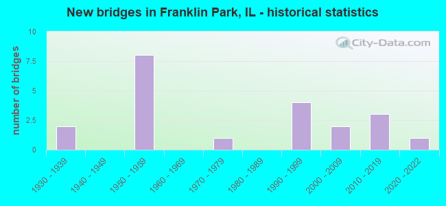
- New bridges - historical statistics
- 21930-1939
- 81950-1959
- 11970-1979
- 41990-1999
- 22000-2009
- 32010-2019
- 12020-2022
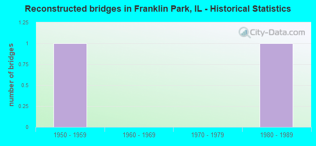
- Reconstructed bridges - Historical Statistics
- 11950-1959
- 01960-1969
- 01970-1979
- 11980-1989
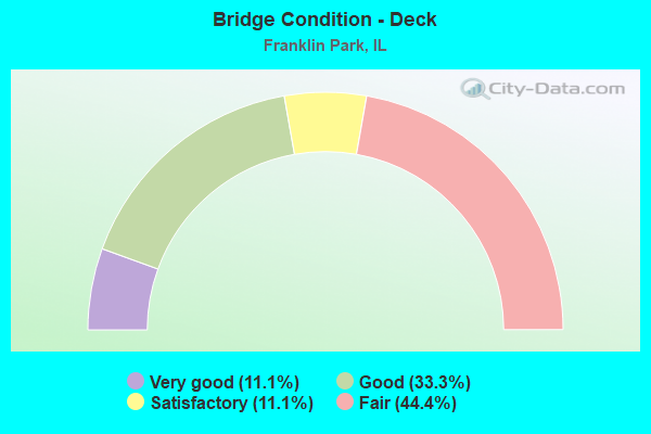
- Bridge Condition - Deck
- 11.1%Very good
- 33.3%Good
- 11.1%Satisfactory
- 44.4%Fair
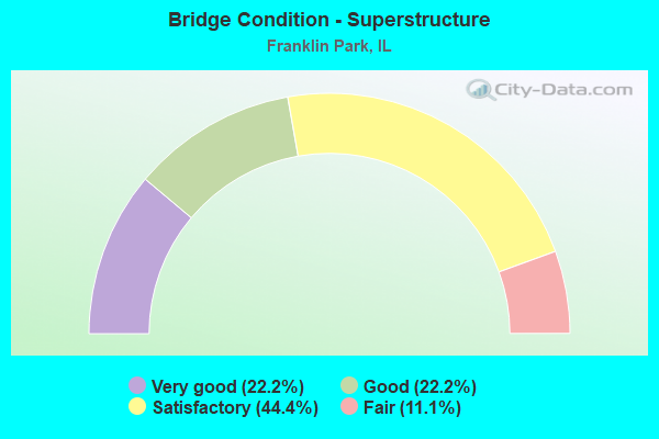
- Bridge Condition - Superstructure
- 22.2%Very good
- 22.2%Good
- 44.4%Satisfactory
- 11.1%Fair
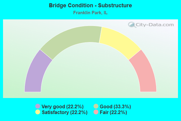
- Bridge Condition - Substructure
- 22.2%Very good
- 33.3%Good
- 22.2%Satisfactory
- 22.2%Fair

- Bridge Condition - Channel
- 12.5%Excellent
- 12.5%Very good
- 50.0%Good
- 25.0%Satisfactory
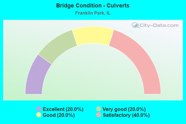
- Bridge Condition - Culverts
- 20.0%Excellent
- 20.0%Very good
- 20.0%Good
- 40.0%Satisfactory
Find on map >> Show street view
Structure Number: 162151, Location: .33 M S OF GRAND AVE (Lat: 41.928242, Lng: -87.884589), Route carried "on" structure: US 12, Year Built: 1977, Status: Open, Structure Length: 2.28m (7.48ft), Average Daily Traffic: 25,300 (year 2021), Truck Traffic: 5%, Average Future Daily Traffic: 38,419 (year 2032), Features Intersected: SILVER CREEK
Minimum Vertical Clearance: 30+ m (98+ ft), Kilometerpoint: 82.815, Lanes on structure: 6, Base Highway Network: Yes, Owner: State Highway Agency, Approaching Roadway Width: 56.4m (185.0ft), Skew: 27 degrees, Material/Design: Concrete continuous, Design/Construction: Culvert, Number Of Spans In Main Unit: 2, Length of Maximum Span: 11.1m (36.4ft), Curb or Sidewalk Widths: Left: 2.0m (6.6ft), Right: 2.0m (6.6ft)
Condition: Channel: Good, Culverts: Good, Operating Rating: 54.8 metric tons, Method Used To Determine Operating Rating: Load Factor (LF) rating reported by rating factor (RF) method using MS18 loading, Inventory Rating: 33.0 metric tons, Method Used To Determine Inventory Rating: Load Factor (LF) rating reported by rating factor (RF) method using MS18 loading, Structural Evaluation: Better than present minimum criteria, Waterway Adequacy: Equal to present desirable criteria, Approach Roadway Alignment: Equal to present desirable criteria, Designated Inspection Frequency: Every 48 months, Inspection Date: April 2020
Find on map >> Show street view
Structure Number: 162422, Location: 0.3 M W US 12,20 (Lat: 41.930453, Lng: -87.889961), Route carried "on" structure: Other road , Year Built: 1930, Year Reconstructed: 1963, Status: Open, Structure Length: 0.64m (2.10ft), Average Daily Traffic: 40,000 (year 2021), Truck Traffic: 34%, Average Future Daily Traffic: 29,355 (year 2032), Features Intersected: SILVER CREEK, Facility Carried by Structure: GRAND AVE
Minimum Vertical Clearance: 30+ m (98+ ft), Kilometerpoint: 2.527, Lanes on structure: 4, Base Highway Network: Yes, Owner: State Highway Agency, Approaching Roadway Width: 15.5m (50.9ft), Skew: 2 degrees, Material/Design: Concrete continuous, Design/Construction: Culvert, Number Of Spans In Main Unit: 2, Length of Maximum Span: 2.7m (8.9ft), Curb or Sidewalk Widths: Left: 0.0m, Right: 1.8m (5.9ft)
Condition: Channel: Satisfactory, Culverts: Satisfactory, Operating Rating: 43.1 metric tons, Method Used To Determine Operating Rating: Load Factor (LF) rating reported by rating factor (RF) method using MS18 loading, Inventory Rating: 25.9 metric tons, Method Used To Determine Inventory Rating: Load Factor (LF) rating reported by rating factor (RF) method using MS18 loading, Structural Evaluation: Equal to present minimum criteria, Waterway Adequacy: Equal to present desirable criteria, Approach Roadway Alignment: Equal to present desirable criteria, Designated Inspection Frequency: Every 24 months, Inspection Date: June 2021
Find on map >> Show street view
Structure Number: 162608, Location: 2.2 M N IL 64 (Lat: 41.938933, Lng: -87.904489), Route carried "on" structure: Other road , Year Built: 1992, Status: Open, Structure Length: 8.11m (26.61ft), Average Daily Traffic: 9,850 (year 2021), Truck Traffic: 14%, Average Future Daily Traffic: 9,373 (year 2032), Design Load: HS 20, Features Intersected: I-294 TRI STATE TOLL, Facility Carried by Structure: WOLF RD
Minimum Vertical Clearance: 30+ m (98+ ft), Kilometerpoint: 0.692, Lanes on structure: 2, Lanes under structure: 8, Owner: State Highway Agency, Approaching Roadway Width: 10.4m (34.1ft), Skew: 1 degrees, Material/Design: Steel continuous, Design/Construction: Stringer/Multi-beam, Number Of Spans In Main Unit: 2, Number Of Approach Spans: 2, Length of Maximum Span: 31.7m (104.0ft), Curb-To-Curb Width: 12.2m (40.0ft), Out-to-Out Width: 13.2m (43.3ft)
Condition: Deck: Satisfactory, Superstructure: Satisfactory, Substructure: Good, Operating Rating: 84.6 metric tons, Method Used To Determine Operating Rating: Load Factor (LF) rating reported by rating factor (RF) method using MS18 loading, Inventory Rating: 50.5 metric tons, Method Used To Determine Inventory Rating: Load Factor (LF) rating reported by rating factor (RF) method using MS18 loading, Structural Evaluation: Equal to present minimum criteria, Deck Geometry: Somewhat better than minimum adequacy, Underclear: Meets minimum limits, Approach Roadway Alignment: Equal to present desirable criteria, Designated Inspection Frequency: Every 24 months, Inspection Date: May 2020, Deck Structure Type: Concrete Cast-file-Place, Wearing Surface/Protective System: Deck Protection: Epoxy Coated Reinforcing
Find on map >> Show street view
Structure Number: 162651, Location: 2.2 M W IL 43 (Lat: 41.937253, Lng: -87.849972), Route carried "on" structure: Other road , Year Built: 2001, Status: Open, Structure Length: 6.69m (21.95ft), Average Daily Traffic: 22,000 (year 2021), Truck Traffic: 2%, Average Future Daily Traffic: 25,441 (year 2032), Features Intersected: DES PLAINES RIVER, Facility Carried by Structure: BELMONT AVE
Minimum Vertical Clearance: 30+ m (98+ ft), Kilometerpoint: 1.304, Lanes on structure: 4, Base Highway Network: Yes, Owner: State Highway Agency, Approaching Roadway Width: 16.3m (53.5ft), Skew: 3 degrees, Material/Design: Steel continuous, Design/Construction: Stringer/Multi-beam, Number Of Spans In Main Unit: 3, Length of Maximum Span: 22.0m (72.2ft), Curb or Sidewalk Widths: Left: 3.5m (11.5ft), Right: 0.0m, Curb-To-Curb Width: 22.8m (74.8ft), Out-to-Out Width: 27.1m (88.9ft)
Condition: Deck: Very good, Superstructure: Very good, Substructure: Very good, Channel: Good, Operating Rating: 89.1 metric tons, Method Used To Determine Operating Rating: Load Factor (LF) rating reported by rating factor (RF) method using MS18 loading, Inventory Rating: 54.4 metric tons, Method Used To Determine Inventory Rating: Load Factor (LF) rating reported by rating factor (RF) method using MS18 loading, Structural Evaluation: Equal to present desirable criteria, Deck Geometry: Superior to present desirable criteria, Waterway Adequacy: Superior to present desirable criteria, Approach Roadway Alignment: Equal to present desirable criteria, Designated Inspection Frequency: Every 48 months, Inspection Date: July 2021, Deck Structure Type: Concrete Cast-file-Place, Wearing Surface/Protective System: Deck Protection: Epoxy Coated Reinforcing
Find on map >> Show street view
Structure Number: 162746, Location: 1.7 MI N. OF US 20 (Lat: 41.932514, Lng: -87.919267), Route carried "on" structure: Interstate 294, Year Built: 1959, Year Reconstructed: 1991, Status: Open, Structure Length: 0.87m (2.85ft), Average Daily Traffic: 146,200 (year 2020), Truck Traffic: 15%, Average Future Daily Traffic: 156,354 (year 2032), Design Load: HS 20, Features Intersected: SILVER CREEK
Minimum Vertical Clearance: 30+ m (98+ ft), Kilometerpoint: 28.211, Lanes on structure: 8, Base Highway Network: Yes, Toll: On toll road, Owner: State Toll Authority, Approaching Roadway Width: 46.3m (151.9ft), Material/Design: Concrete, Design/Construction: Culvert, Number Of Spans In Main Unit: 2, Length of Maximum Span: 3.7m (12.1ft)
Condition: Channel: Satisfactory, Culverts: Satisfactory, Operating Rating: 89.1 metric tons, Method Used To Determine Operating Rating: Load Factor (LF) rating reported by rating factor (RF) method using MS18 loading, Inventory Rating: 89.1 metric tons, Method Used To Determine Inventory Rating: Load Factor (LF) rating reported by rating factor (RF) method using MS18 loading, Structural Evaluation: Equal to present minimum criteria, Waterway Adequacy: Superior to present desirable criteria, Approach Roadway Alignment: Equal to present desirable criteria, Designated Inspection Frequency: Every 24 months, Inspection Date: April 2021, Deck Structure Type: Concrete Cast-file-Place
Find on map >> Show street view
Structure Number: 162815, Location: 2.0 M S IL 19 (Lat: 41.943439, Lng: -87.885250), Route carried "on" structure: US 12, Year Built: 2010, Status: Open, Structure Length: 38.11m (125.03ft), Average Daily Traffic: 46,200 (year 2021), Truck Traffic: 10%, Average Future Daily Traffic: 39,243 (year 2032), Design Load: HS 20, Features Intersected: RR - METRA, CP, RDS
Minimum Vertical Clearance: 30+ m (98+ ft), Kilometerpoint: 81.093, Lanes on structure: 6, Lanes under structure: 4, Base Highway Network: Yes, Owner: State Highway Agency, Approaching Roadway Width: 25.6m (84.0ft), Skew: 32 degrees, Material/Design: Steel continuous, Design/Construction: Stringer/Multi-beam, Number Of Spans In Main Unit: 14, Length of Maximum Span: 41.4m (135.8ft), Curb or Sidewalk Widths: Left: 2.3m (7.5ft), Right: 2.3m (7.5ft), Curb-To-Curb Width: 24.7m (81.0ft), Out-to-Out Width: 30.5m (100.1ft)
Condition: Deck: Good, Superstructure: Very good, Substructure: Very good, Operating Rating: 65.1 metric tons, Method Used To Determine Operating Rating: Load Factor (LF) rating reported by rating factor (RF) method using MS18 loading, Inventory Rating: 39.2 metric tons, Method Used To Determine Inventory Rating: Load Factor (LF) rating reported by rating factor (RF) method using MS18 loading, Structural Evaluation: Equal to present desirable criteria, Deck Geometry: Somewhat better than minimum adequacy, Approach Roadway Alignment: Better than present minimum criteria, Designated Inspection Frequency: Every 24 months, Inspection Date: August 2021, Deck Structure Type: Concrete Cast-file-Place, Wearing Surface/Protective System: Deck Protection: Epoxy Coated Reinforcing
Find on map >> Show street view
Structure Number: 162856, Location: 0.7 M E OF US 45 (Lat: 41.922211, Lng: -87.871128), Route carried "on" structure: Other road , Year Built: 2012, Status: Open, Structure Length: 2.32m (7.61ft), Average Daily Traffic: 5,450 (year 2021), Truck Traffic: 9%, Average Future Daily Traffic: 6,386 (year 2032), Features Intersected: SILVER CREEK, Facility Carried by Structure: FULLERTON AVE
Minimum Vertical Clearance: 30+ m (98+ ft), Kilometerpoint: 2.704, Lanes on structure: 2, Owner: State Highway Agency, Approaching Roadway Width: 12.2m (40.0ft), Skew: 5 degrees, Material/Design: Concrete continuous, Design/Construction: Culvert, Number Of Spans In Main Unit: 4, Length of Maximum Span: 6.4m (21.0ft)
Condition: Channel: Good, Culverts: Very good, Operating Rating: 66.7 metric tons, Method Used To Determine Operating Rating: Load Factor (LF) rating reported by rating factor (RF) method using MS18 loading, Inventory Rating: 40.2 metric tons, Method Used To Determine Inventory Rating: Load Factor (LF) rating reported by rating factor (RF) method using MS18 loading, Structural Evaluation: Equal to present desirable criteria, Waterway Adequacy: Better than present minimum criteria, Approach Roadway Alignment: Equal to present desirable criteria, Designated Inspection Frequency: Every 48 months, Inspection Date: September 2018, Deck Structure Type: Other
Find on map >> Show street view
Structure Number: 163249, Location: .2 MI W 25TH AVE (Lat: 41.918656, Lng: -87.869297), Route carried "on" structure: County highway , Year Built: 1994, Status: Open, Structure Length: 1.04m (3.41ft), Average Daily Traffic: 525 (year 2018), Truck Traffic: 9%, Average Future Daily Traffic: 700 (year 2032), Design Load: HS 20, Features Intersected: SILVER CREEK, Facility Carried by Structure: PALMER AVENUE
Minimum Vertical Clearance: 30+ m (98+ ft), Kilometerpoint: 0.982, Lanes on structure: 2, Owner: Town or Township Highway Agency, Approaching Roadway Width: 7.3m (24.0ft), Skew: 6 degrees, Material/Design: Concrete, Design/Construction: Slab, Number Of Spans In Main Unit: 1, Number Of Approach Spans: 1, Length of Maximum Span: 10.0m (32.8ft), Curb or Sidewalk Widths: Left: 1.5m (4.9ft), Right: 1.5m (4.9ft), Curb-To-Curb Width: 8.5m (27.9ft), Out-to-Out Width: 12.2m (40.0ft)
Condition: Deck: Good, Superstructure: Good, Substructure: Good, Channel: Good, Operating Rating: 88.8 metric tons, Method Used To Determine Operating Rating: Load Factor (LF) rating reported by rating factor (RF) method using MS18 loading, Inventory Rating: 80.4 metric tons, Method Used To Determine Inventory Rating: Load Factor (LF) rating reported by rating factor (RF) method using MS18 loading, Structural Evaluation: Better than present minimum criteria, Deck Geometry: Somewhat better than minimum adequacy, Waterway Adequacy: Better than present minimum criteria, Approach Roadway Alignment: Equal to present desirable criteria, Designated Inspection Frequency: Every 48 months, Inspection Date: June 2020, Deck Structure Type: Concrete Cast-file-Place, Wearing Surface/Protective System: Deck Protection: Epoxy Coated Reinforcing
Find on map >> Show street view
Structure Number: 163279, Location: 0.15 M S of Grand Av (Lat: 41.928253, Lng: -87.888258), Route carried "on" structure: County highway , Year Built: 2004, Status: Open, Structure Length: 1.14m (3.74ft), Average Daily Traffic: 300 (year 2018), Truck Traffic: 14%, Average Future Daily Traffic: 232 (year 2032), Design Load: HS 20, Features Intersected: SILVER CREEK, Facility Carried by Structure: GRANVILLE AV
Minimum Vertical Clearance: 30+ m (98+ ft), Kilometerpoint: 0.097, Lanes on structure: 2, Owner: Town or Township Highway Agency, Approaching Roadway Width: 6.7m (22.0ft), Material/Design: Prestressed concrete, Design/Construction: Box Beam or Girders - Multiple, Number Of Spans In Main Unit: 1, Length of Maximum Span: 11.0m (36.1ft), Curb-To-Curb Width: 9.8m (32.2ft), Out-to-Out Width: 10.8m (35.4ft)
Condition: Deck: Good, Superstructure: Good, Substructure: Good, Channel: Very good, Operating Rating: 76.1 metric tons, Method Used To Determine Operating Rating: Load Factor (LF) rating reported by rating factor (RF) method using MS18 loading, Inventory Rating: 45.4 metric tons, Method Used To Determine Inventory Rating: Load Factor (LF) rating reported by rating factor (RF) method using MS18 loading, Structural Evaluation: Better than present minimum criteria, Deck Geometry: Better than present minimum criteria, Waterway Adequacy: Equal to present desirable criteria, Approach Roadway Alignment: Equal to present desirable criteria, Designated Inspection Frequency: Every 48 months, Inspection Date: June 2020, Deck Structure Type: Concrete Precast Panels, Wearing Surface/Protective System: Wearing Surface: Integral Concrete, Deck Protection: Epoxy Coated Reinforcing
Find on map >> Show street view
Structure Number: 166813, Location: 0.17 MI W I-294 (Lat: 41.941669, Lng: -87.895600), Route carried "on" structure: Other road , Year Built: 2021, Status: Open, Structure Length: 1.05m (3.44ft), Average Daily Traffic: 11,300 (year 2014), Truck Traffic: 15%, Average Future Daily Traffic: 12,044 (year 2050), Design Load: HS 25 or greater, Features Intersected: Silver Creek, Facility Carried by Structure: Franklin Ave
Minimum Vertical Clearance: 30+ m (98+ ft), Kilometerpoint: 2.205, Lanes on structure: 4, Base Highway Network: Yes, Owner: City or Municipal Highway Agency, Approaching Roadway Width: 17.1m (56.1ft), Skew: 4 degrees, Material/Design: Concrete continuous, Design/Construction: Culvert, Number Of Spans In Main Unit: 2, Length of Maximum Span: 0.0m, Curb or Sidewalk Widths: Left: 0.0m, Right: 2.4m (7.9ft), Curb-To-Curb Width: 17.1m (56.1ft)
Condition: Channel: Excellent, Culverts: Excellent, Deck Geometry: Somewhat better than minimum adequacy, Waterway Adequacy: Superior to present desirable criteria, Approach Roadway Alignment: Superior to present desirable criteria, Designated Inspection Frequency: Every 24 months, Inspection Date: November 2021
Find on map >> Show street view
Structure Number: 169786, Location: 2.5 M SW ILL 19 P9 (Lat: 41.937031, Lng: -87.914169), Route carried "on" structure: Interstate 294, Year Built: 1958, Status: Open, Structure Length: 4.91m (16.11ft), Average Daily Traffic: 73,100 (year 2020), Truck Traffic: 15%, Average Future Daily Traffic: 78,177 (year 2032), Features Intersected: C&NW RR
Minimum Vertical Clearance: 30+ m (98+ ft), Kilometerpoint: 27.535, Lanes on structure: 3, Base Highway Network: Yes, Toll: On toll road, Owner: State Toll Authority, Approaching Roadway Width: 15.8m (51.8ft), Skew: 2 degrees, Material/Design: Prestressed concrete, Design/Construction: Stringer/Multi-beam, Number Of Spans In Main Unit: 3, Length of Maximum Span: 16.8m (55.1ft), Curb-To-Curb Width: 14.2m (46.6ft), Out-to-Out Width: 20.1m (65.9ft)
Condition: Deck: Fair, Superstructure: Satisfactory, Substructure: Fair, Operating Rating: 66.7 metric tons, Method Used To Determine Operating Rating: Load Factor (LF) rating reported by rating factor (RF) method using MS18 loading, Inventory Rating: 39.9 metric tons, Method Used To Determine Inventory Rating: Load Factor (LF) rating reported by rating factor (RF) method using MS18 loading, Structural Evaluation: Somewhat better than minimum adequacy, Deck Geometry: Meets minimum limits, Underclear: Superior to present desirable criteria, Approach Roadway Alignment: Equal to present desirable criteria, Designated Inspection Frequency: Every 24 months, Inspection Date: April 2021, Deck Structure Type: Concrete Cast-file-Place, Wearing Surface/Protective System: Wearing Surface: Bituminous, Membrane: Built-up
Find on map >> Show street view
Structure Number: 169787, Location: 2.5 M SW ILL 19 P9 (Lat: 41.936961, Lng: -87.914339), Route carried "on" structure: Interstate 294, Year Built: 1958, Status: Open, Structure Length: 4.91m (16.11ft), Average Daily Traffic: 73,100 (year 2020), Truck Traffic: 15%, Average Future Daily Traffic: 78,177 (year 2032), Features Intersected: C&NW RR
Minimum Vertical Clearance: 30+ m (98+ ft), Kilometerpoint: 27.551, Lanes on structure: 3, Base Highway Network: Yes, Toll: On toll road, Owner: State Toll Authority, Approaching Roadway Width: 15.8m (51.8ft), Skew: 2 degrees, Material/Design: Prestressed concrete, Design/Construction: Stringer/Multi-beam, Number Of Spans In Main Unit: 3, Length of Maximum Span: 16.8m (55.1ft), Curb-To-Curb Width: 14.2m (46.6ft), Out-to-Out Width: 18.6m (61.0ft)
Condition: Deck: Fair, Superstructure: Fair, Substructure: Fair, Operating Rating: 77.4 metric tons, Method Used To Determine Operating Rating: Load Factor (LF) rating reported by rating factor (RF) method using MS18 loading, Inventory Rating: 46.3 metric tons, Method Used To Determine Inventory Rating: Load Factor (LF) rating reported by rating factor (RF) method using MS18 loading, Structural Evaluation: Somewhat better than minimum adequacy, Deck Geometry: Meets minimum limits, Underclear: Superior to present desirable criteria, Approach Roadway Alignment: Equal to present desirable criteria, Designated Inspection Frequency: Every 24 months, Inspection Date: April 2021, Deck Structure Type: Concrete Cast-file-Place, Wearing Surface/Protective System: Wearing Surface: Bituminous, Membrane: Built-up
Find on map >> Show street view
Structure Number: 169788, Location: 2.6 M SW ILL 19 P9 (Lat: 41.931453, Lng: -87.919650), Route carried "on" structure: Interstate 294, Year Built: 1958, Status: Open, Structure Length: 2.13m (6.99ft), Average Daily Traffic: 73,100 (year 2020), Truck Traffic: 15%, Average Future Daily Traffic: 78,177 (year 2032), Features Intersected: GRAND AVE
Minimum Vertical Clearance: 30+ m (98+ ft), Kilometerpoint: 28.324, Lanes on structure: 3, Lanes under structure: 4, Base Highway Network: Yes, Toll: On toll road, Owner: State Toll Authority, Approaching Roadway Width: 15.8m (51.8ft), Material/Design: Prestressed concrete, Design/Construction: Stringer/Multi-beam, Number Of Spans In Main Unit: 1, Length of Maximum Span: 20.4m (66.9ft), Curb-To-Curb Width: 14.2m (46.6ft), Out-to-Out Width: 18.6m (61.0ft)
Condition: Deck: Fair, Superstructure: Satisfactory, Substructure: Satisfactory, Operating Rating: 73.9 metric tons, Method Used To Determine Operating Rating: Load Factor (LF) rating reported by rating factor (RF) method using MS18 loading, Inventory Rating: 44.4 metric tons, Method Used To Determine Inventory Rating: Load Factor (LF) rating reported by rating factor (RF) method using MS18 loading, Structural Evaluation: Equal to present minimum criteria, Deck Geometry: Meets minimum limits, Underclear: Meets minimum limits, Approach Roadway Alignment: Equal to present desirable criteria, Designated Inspection Frequency: Every 24 months, Inspection Date: May 2020, Deck Structure Type: Concrete Cast-file-Place, Wearing Surface/Protective System: Wearing Surface: Bituminous, Membrane: Built-up
Find on map >> Show street view
Structure Number: 169789, Location: 2.6 M SW ILL 19 P9 (Lat: 41.931269, Lng: -87.919686), Route carried "on" structure: Interstate 294, Year Built: 1958, Status: Open, Structure Length: 2.13m (6.99ft), Average Daily Traffic: 73,100 (year 2020), Truck Traffic: 15%, Average Future Daily Traffic: 78,177 (year 2032), Features Intersected: GRAND AVE
Minimum Vertical Clearance: 30+ m (98+ ft), Kilometerpoint: 28.340, Lanes on structure: 3, Lanes under structure: 4, Base Highway Network: Yes, Toll: On toll road, Owner: State Toll Authority, Approaching Roadway Width: 15.8m (51.8ft), Material/Design: Prestressed concrete, Design/Construction: Stringer/Multi-beam, Number Of Spans In Main Unit: 1, Length of Maximum Span: 20.4m (66.9ft), Curb-To-Curb Width: 14.2m (46.6ft), Out-to-Out Width: 18.6m (61.0ft)
Condition: Deck: Fair, Superstructure: Satisfactory, Substructure: Satisfactory, Operating Rating: 77.8 metric tons, Method Used To Determine Operating Rating: Load Factor (LF) rating reported by rating factor (RF) method using MS18 loading, Inventory Rating: 46.7 metric tons, Method Used To Determine Inventory Rating: Load Factor (LF) rating reported by rating factor (RF) method using MS18 loading, Structural Evaluation: Equal to present minimum criteria, Deck Geometry: Meets minimum limits, Underclear: Meets minimum limits, Approach Roadway Alignment: Equal to present desirable criteria, Designated Inspection Frequency: Every 24 months, Inspection Date: May 2020, Deck Structure Type: Concrete Cast-file-Place, Wearing Surface/Protective System: Wearing Surface: Bituminous, Membrane: Built-up
Find on map >> Show street view
Structure Number: 160853, Location: 1.25 M W I294 P9 (Lat: 41.947719, Lng: -87.913283), Route carried "under" structure: Other road , Year Built: 1936, Structure Length: 0. m, Average Daily Traffic: 12,900 (year 2018), Truck Traffic: 16%, Features Intersected: FRANKLIN AVE, Facility Carried by Structure: C&NW RR
Minimum Vertical Clearance: 6.10m (20.01ft), Kilometerpoint: 0.483, Lanes under structure: 2, Material/Design: Steel, Length of Maximum Span: 7.6m (24.9ft)
Find on map >> Show street view
Structure Number: 162608, Location: 2.2 M N IL 64 (Lat: 41.938933, Lng: -87.904489), Route carried "under" structure: Interstate 294, Year Built: 1992, Structure Length: 0. m, Average Daily Traffic: 146,200 (year 2020), Truck Traffic: 15%, Features Intersected: I-294 TRI STATE TOLL, Facility Carried by Structure: WOLF RD
Minimum Vertical Clearance: 4.65m (15.26ft), Kilometerpoint: 26.698, Lanes on structure: 2, Lanes under structure: 8, Material/Design: Steel continuous, Design/Construction: Stringer/Multi-beam, Length of Maximum Span: 31.7m (104.0ft)
Find on map >> Show street view
Structure Number: 162681, Location: 1 M S ILL 19 P9 (Lat: 41.945594, Lng: -87.885397), Route carried "under" structure: US 12, Year Built: 1993, Structure Length: 0. m, Average Daily Traffic: 46,200 (year 2021), Truck Traffic: 10%, Features Intersected: US-45,RR YDS.& F.AVE, Facility Carried by Structure: I-294 SB
Minimum Vertical Clearance: 5.94m (19.49ft), Kilometerpoint: 80.932, Lanes on structure: 4, Lanes under structure: 4, Toll: On toll road, Material/Design: Prestressed concrete continuous, Design/Construction: Stringer/Multi-beam, Length of Maximum Span: 67.6m (221.8ft)
Find on map >> Show street view
Structure Number: 162815, Location: 2.0 M S IL 19 (Lat: 41.940519, Lng: -87.885100), Route carried "under" structure: Other road , Year Built: 2010, Structure Length: 0. m, Average Daily Traffic: 11,300 (year 2014), Truck Traffic: 15%, Features Intersected: RR - METRA, CP, RDS, Facility Carried by Structure: US 12,45 MANNHEIM
Minimum Vertical Clearance: 4.75m (15.58ft), Kilometerpoint: 3.154, Lanes on structure: 6, Lanes under structure: 4, Material/Design: Steel continuous, Design/Construction: Stringer/Multi-beam, Length of Maximum Span: 41.4m (135.8ft)
Find on map >> Show street view
Structure Number: 169785, Location: 1 M S ILL 19 P9 (Lat: 41.945472, Lng: -87.885392), Route carried "under" structure: US 12, Year Built: 1958, Structure Length: 0. m, Average Daily Traffic: 46,200 (year 2021), Truck Traffic: 10%, Features Intersected: US-45,RR YDS.& F.AVE, Facility Carried by Structure: I-294 NB
Minimum Vertical Clearance: 5.94m (19.49ft), Kilometerpoint: 80.948, Lanes on structure: 6, Lanes under structure: 4, Toll: On toll road, Material/Design: Steel, Design/Construction: Stringer/Multi-beam, Length of Maximum Span: 47.2m (154.9ft)
Find on map >> Show street view
Structure Number: 169788, Location: 2.6 M SW ILL 19 P9 (Lat: 41.931269, Lng: -87.919686), Route carried "under" structure: Other road , Year Built: 1958, Structure Length: 0. m, Average Daily Traffic: 25,600 (year 2021), Truck Traffic: 8%, Features Intersected: GRAND AVE, Facility Carried by Structure: I-294 NB
Minimum Vertical Clearance: 4.42m (14.50ft), Kilometerpoint: 0.048, Lanes on structure: 3, Lanes under structure: 4, Toll: On toll road, Material/Design: Prestressed concrete, Design/Construction: Stringer/Multi-beam, Length of Maximum Span: 20.4m (66.9ft)
Find on map >> Show street view
Structure Number: 169789, Location: 2.6 M SW ILL 19 P9 (Lat: 41.931286, Lng: -87.920050), Route carried "under" structure: Other road , Year Built: 1958, Structure Length: 0. m, Average Daily Traffic: 25,600 (year 2021), Truck Traffic: 8%, Features Intersected: GRAND AVE, Facility Carried by Structure: I-294 SB
Minimum Vertical Clearance: 4.27m (14.01ft), Kilometerpoint: 0.032, Lanes on structure: 3, Lanes under structure: 4, Toll: On toll road, Material/Design: Prestressed concrete, Design/Construction: Stringer/Multi-beam, Length of Maximum Span: 20.4m (66.9ft)