Bridge Statistics for Franklin, Tennessee (TN)
Condition, Traffic, Stress, Structural Evaluation, Project Costs
- National Bridge Inventory (NBI) Statistics
- 122Number of bridges
- 1,194ft / 364mTotal length
- $28,137,000Total costs
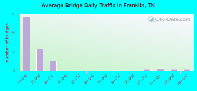
- 1,783,913Total average daily traffic
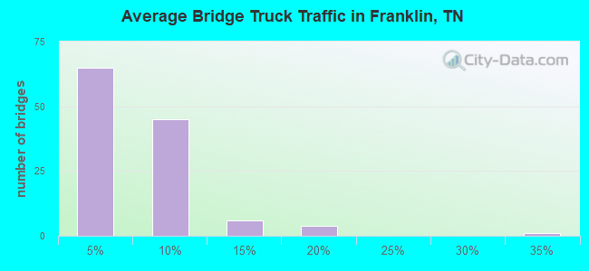
- 208,005Total average daily truck traffic
- National Bridge Inventory (NBI) Registered Bridges for Franklin
- No street view available for this location
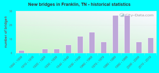
- New bridges - historical statistics
- 21900-1909
- 31920-1929
- 31930-1939
- 61940-1949
- 121950-1959
- 151960-1969
- 81970-1979
- 271980-1989
- 271990-1999
- 82000-2009
- 112010-2019
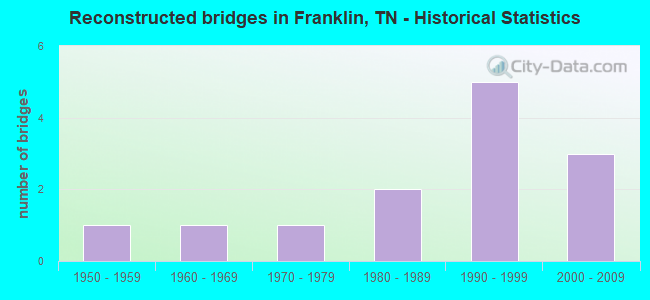
- Reconstructed bridges - Historical Statistics
- 11950-1959
- 11960-1969
- 11970-1979
- 21980-1989
- 51990-1999
- 32000-2009
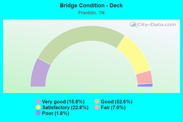
- Bridge Condition - Deck
- 15.8%Very good
- 52.6%Good
- 22.8%Satisfactory
- 7.0%Fair
- 1.8%Poor
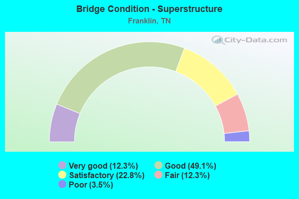
- Bridge Condition - Superstructure
- 12.3%Very good
- 49.1%Good
- 22.8%Satisfactory
- 12.3%Fair
- 3.5%Poor
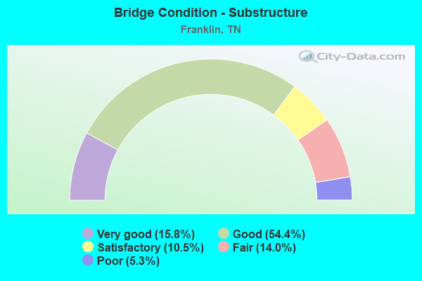
- Bridge Condition - Substructure
- 15.8%Very good
- 54.4%Good
- 10.5%Satisfactory
- 14.0%Fair
- 5.3%Poor
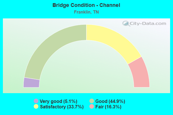
- Bridge Condition - Channel
- 5.1%Very good
- 44.9%Good
- 33.7%Satisfactory
- 16.3%Fair
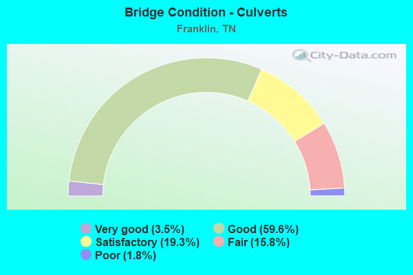
- Bridge Condition - Culverts
- 3.5%Very good
- 59.6%Good
- 19.3%Satisfactory
- 15.8%Fair
- 1.8%Poor
Find on map >> Show street view
Structure Number: 94009940001, Location: 4.2 MI SW JCT SR46&SR96 (Lat: 35.897050, Lng: -86.985983), Route carried "on" structure: County highway 994, Year Built: 1986, Status: Open, Structure Length: 3.96m (12.99ft), Average Daily Traffic: 2,156 (year 2020), Truck Traffic: 3%, Average Future Daily Traffic: 3,450 (year 2042), Design Load: HS 20, Features Intersected: LEIPERS FORK CREEK
Minimum Vertical Clearance: 30+ m (98+ ft), Kilometerpoint: 0.563, Lanes on structure: 2, Owner: County Highway Agency, Approaching Roadway Width: 7.9m (25.9ft), Skew: 4 degrees, Material/Design: Prestressed concrete, Design/Construction: Stringer/Multi-beam, Number Of Spans In Main Unit: 3, Length of Maximum Span: 13.4m (44.0ft), Curb-To-Curb Width: 8.5m (27.9ft), Out-to-Out Width: 9.2m (30.2ft)
Condition: Deck: Good, Superstructure: Satisfactory, Substructure: Good, Channel: Fair, Operating Rating: 45.0 metric tons, Method Used To Determine Operating Rating: Load and Resistance Factor Rating (LRFR) rating reported by rating factor(RF) method using HL-93 loadings, Inventory Rating: 34.7 metric tons, Method Used To Determine Inventory Rating: Load and Resistance Factor Rating (LRFR) rating reported by rating factor(RF) method using HL-93 loadings, Structural Evaluation: Equal to present minimum criteria, Deck Geometry: Meets minimum limits, Waterway Adequacy: Somewhat better than minimum adequacy, Approach Roadway Alignment: Equal to present desirable criteria, Length Of Structure Improvement: 3.96m (12.99ft), Designated Inspection Frequency: Every 24 months, Inspection Date: May 2021, Bridge Improvement Cost: $394,000, Roadway Improvement Cost: $40,000, Total Project Cost: $592,000 ( Estimate for 2022), Deck Structure Type: Concrete Precast Panels, Wearing Surface/Protective System: Wearing Surface: Bituminous
Find on map >> Show street view
Structure Number: 94019270001, Location: 2.2 MI NE JCT SR46&SR96 (Lat: 35.964217, Lng: -86.918583), Route carried "on" structure: County highway 4748, Year Built: 1950, Status: Posted for load, Structure Length: 2.87m (9.42ft), Average Daily Traffic: 1,847 (year 2020), Truck Traffic: 4%, Average Future Daily Traffic: 2,955 (year 2041), Design Load: H 15, Features Intersected: WEST HARPETH RIVER
Minimum Vertical Clearance: 30+ m (98+ ft), Kilometerpoint: 1.625, Lanes on structure: 2, Owner: County Highway Agency, Approaching Roadway Width: 5.2m (17.1ft), Material/Design: Concrete, Design/Construction: Tee Beam, Number Of Spans In Main Unit: 2, Length of Maximum Span: 13.7m (44.9ft), Curb-To-Curb Width: 6.6m (21.7ft), Out-to-Out Width: 7.7m (25.3ft)
Condition: Deck: Satisfactory, Superstructure: Satisfactory, Substructure: Fair, Channel: Fair, Operating Rating: 36.0 metric tons, Method Used To Determine Operating Rating: Field evaluation and documented engineering judgment, Inventory Rating: 24.3 metric tons, Method Used To Determine Inventory Rating: Field evaluation and documented engineering judgment, Structural Evaluation: Somewhat better than minimum adequacy, Deck Geometry: High priority of replacement, Waterway Adequacy: Somewhat better than minimum adequacy, Approach Roadway Alignment: Equal to present minimum criteria, Length Of Structure Improvement: 2.87m (9.42ft), Designated Inspection Frequency: Every 24 months, Inspection Date: July 2021, Bridge Improvement Cost: $251,000, Roadway Improvement Cost: $26,000, Total Project Cost: $377,000 ( Estimate for 2021), Deck Structure Type: Concrete Cast-file-Place, Wearing Surface/Protective System: Wearing Surface: Bituminous
Find on map >> Show street view
Structure Number: 94019290001, Location: 2.6 MI NE JCT SR46&SR96 (Lat: 35.980200, Lng: -86.931267), Route carried "on" structure: County highway 1929, Year Built: 1984, Status: Open, Structure Length: 0.82m (2.69ft), Average Daily Traffic: 2,071 (year 2020), Truck Traffic: 5%, Average Future Daily Traffic: 3,314 (year 2041), Design Load: HS 20, Features Intersected: MURRAY BRANCH
Minimum Vertical Clearance: 30+ m (98+ ft), Kilometerpoint: 0.853, Lanes on structure: 2, Owner: County Highway Agency, Approaching Roadway Width: 5.5m (18.0ft), Skew: 1 degrees, Material/Design: Concrete continuous, Design/Construction: Culvert, Number Of Spans In Main Unit: 2, Length of Maximum Span: 3.7m (12.1ft), Curb-To-Curb Width: 7.7m (25.3ft), Out-to-Out Width: 9.1m (29.9ft)
Condition: Channel: Satisfactory, Culverts: Satisfactory, Operating Rating: 41.4 metric tons, Method Used To Determine Operating Rating: Load Factor (LF), Inventory Rating: 25.2 metric tons, Method Used To Determine Inventory Rating: Load Factor (LF), Structural Evaluation: Equal to present minimum criteria, Deck Geometry: High priority of replacement, Waterway Adequacy: Equal to present minimum criteria, Approach Roadway Alignment: Equal to present desirable criteria, Designated Inspection Frequency: Every 24 months, Inspection Date: July 2021, Deck Structure Type: Concrete Cast-file-Place, Wearing Surface/Protective System: Wearing Surface: Bituminous, Deck Protection: Epoxy Coated Reinforcing
Find on map >> Show street view
Structure Number: 94019360005, Location: 2.4 MI NW JCT SR96&SR252 (Lat: 35.899817, Lng: -86.728683), Route carried "on" structure: County highway 1936, Year Built: 1983, Status: Open, Structure Length: 0.82m (2.69ft), Average Daily Traffic: 443 (year 2020), Average Future Daily Traffic: 960 (year 2041), Design Load: HS 20, Features Intersected: BURKE BRANCH
Minimum Vertical Clearance: 30+ m (98+ ft), Kilometerpoint: 8.111, Lanes on structure: 2, Owner: County Highway Agency, Approaching Roadway Width: 5.5m (18.0ft), Skew: 1 degrees, Material/Design: Concrete continuous, Design/Construction: Culvert, Number Of Spans In Main Unit: 2, Length of Maximum Span: 3.7m (12.1ft), Curb-To-Curb Width: 7.9m (25.9ft), Out-to-Out Width: 9.2m (30.2ft)
Condition: Channel: Satisfactory, Culverts: Good, Operating Rating: 58.5 metric tons, Method Used To Determine Operating Rating: Load Factor (LF), Inventory Rating: 32.4 metric tons, Method Used To Determine Inventory Rating: Load Factor (LF), Structural Evaluation: Better than present minimum criteria, Deck Geometry: Somewhat better than minimum adequacy, Waterway Adequacy: Equal to present minimum criteria, Approach Roadway Alignment: Equal to present desirable criteria, Length Of Structure Improvement: 0.82m (2.69ft), Designated Inspection Frequency: Every 24 months, Inspection Date: April 2021, Bridge Improvement Cost: $29,000, Roadway Improvement Cost: $3,000, Total Project Cost: $44,000 ( Estimate for 2021), Deck Structure Type: Concrete Cast-file-Place, Wearing Surface/Protective System: Wearing Surface: Bituminous, Deck Protection: Epoxy Coated Reinforcing
Find on map >> Show street view
Structure Number: 94019380001, Location: E. OF US 431 (Lat: 35.975367, Lng: -86.871000), Route carried "on" structure: County highway 1938, Year Built: 1997, Status: Open, Structure Length: 0.95m (3.12ft), Average Daily Traffic: 1,664 (year 2020), Truck Traffic: 4%, Average Future Daily Traffic: 2,662 (year 2041), Design Load: HS 20, Features Intersected: BRANCH
Minimum Vertical Clearance: 30+ m (98+ ft), Kilometerpoint: 3.862, Lanes on structure: 2, Owner: County Highway Agency, Approaching Roadway Width: 10.0m (32.8ft), Skew: 1 degrees, Material/Design: Concrete, Design/Construction: Culvert, Number Of Spans In Main Unit: 1, Length of Maximum Span: 6.6m (21.7ft), Curb-To-Curb Width: 10.2m (33.5ft), Out-to-Out Width: 11.8m (38.7ft)
Condition: Channel: Good, Culverts: Good, Operating Rating: 57.6 metric tons, Method Used To Determine Operating Rating: Load Factor (LF), Inventory Rating: 32.4 metric tons, Method Used To Determine Inventory Rating: Load Factor (LF), Structural Evaluation: Better than present minimum criteria, Deck Geometry: Somewhat better than minimum adequacy, Waterway Adequacy: Better than present minimum criteria, Approach Roadway Alignment: Equal to present desirable criteria, Designated Inspection Frequency: Every 24 months, Inspection Date: July 2021, Deck Structure Type: Concrete Cast-file-Place, Wearing Surface/Protective System: Wearing Surface: Bituminous, Deck Protection: Epoxy Coated Reinforcing
Find on map >> Show street view
Structure Number: 94019380003, Location: E. OF US 431 (Lat: 35.977450, Lng: -86.878917), Route carried "on" structure: County highway 1938, Year Built: 1997, Status: Open, Structure Length: 0.74m (2.43ft), Average Daily Traffic: 1,664 (year 2020), Truck Traffic: 4%, Average Future Daily Traffic: 2,304 (year 2039), Design Load: HS 20, Features Intersected: BRANCH
Minimum Vertical Clearance: 30+ m (98+ ft), Kilometerpoint: 4.554, Lanes on structure: 2, Owner: County Highway Agency, Approaching Roadway Width: 7.6m (24.9ft), Skew: 3 degrees, Material/Design: Concrete continuous, Design/Construction: Culvert, Number Of Spans In Main Unit: 2, Length of Maximum Span: 3.1m (10.2ft)
Condition: Channel: Good, Culverts: Satisfactory, Operating Rating: 54.0 metric tons, Method Used To Determine Operating Rating: Field evaluation and documented engineering judgment, Inventory Rating: 32.4 metric tons, Method Used To Determine Inventory Rating: Field evaluation and documented engineering judgment, Structural Evaluation: Equal to present minimum criteria, Waterway Adequacy: Better than present minimum criteria, Approach Roadway Alignment: Equal to present desirable criteria, Designated Inspection Frequency: Every 24 months, Inspection Date: July 2021, Deck Structure Type: Concrete Cast-file-Place, Wearing Surface/Protective System: Wearing Surface: Bituminous, Deck Protection: Epoxy Coated Reinforcing
Find on map >> Show street view
Structure Number: 94047390001, Location: ON RIVER OAKS BLVD (Lat: 35.907667, Lng: -86.834883), Route carried "on" structure: City street 4739, Year Built: 1989, Status: Open, Structure Length: 1.52m (4.99ft), Average Daily Traffic: 16,718 (year 2020), Truck Traffic: 4%, Average Future Daily Traffic: 26,749 (year 2041), Design Load: HS 20, Features Intersected: WATSON BRANCH
Minimum Vertical Clearance: 30+ m (98+ ft), Kilometerpoint: 1.078, Lanes on structure: 4, Owner: City or Municipal Highway Agency, Approaching Roadway Width: 7.3m (24.0ft), Skew: 1 degrees, Material/Design: Concrete continuous, Design/Construction: Culvert, Number Of Spans In Main Unit: 3, Length of Maximum Span: 4.6m (15.1ft)
Condition: Channel: Fair, Culverts: Good, Operating Rating: 89.1 metric tons, Method Used To Determine Operating Rating: Load Factor (LF), Inventory Rating: 32.4 metric tons, Method Used To Determine Inventory Rating: Load Factor (LF), Structural Evaluation: Better than present minimum criteria, Waterway Adequacy: Equal to present minimum criteria, Approach Roadway Alignment: Equal to present minimum criteria, Length Of Structure Improvement: 1.52m (4.99ft), Designated Inspection Frequency: Every 24 months, Inspection Date: July 2021, Bridge Improvement Cost: $432,000, Roadway Improvement Cost: $44,000, Total Project Cost: $649,000 ( Estimate for 2021)
Find on map >> Show street view
Structure Number: 94047440001, Location: ON COOL SPRINGS BLVD (Lat: 35.940883, Lng: -86.835467), Route carried "on" structure: City street 4744, Year Built: 1987, Status: Open, Structure Length: 1.07m (3.51ft), Average Daily Traffic: 26,256 (year 2020), Truck Traffic: 4%, Average Future Daily Traffic: 42,010 (year 2041), Design Load: HS 20, Features Intersected: BRANCH
Minimum Vertical Clearance: 30+ m (98+ ft), Kilometerpoint: 0.370, Lanes on structure: 4, Owner: City or Municipal Highway Agency, Approaching Roadway Width: 7.3m (24.0ft), Skew: 15 degrees, Material/Design: Concrete continuous, Design/Construction: Culvert, Number Of Spans In Main Unit: 2, Length of Maximum Span: 3.0m (9.8ft), Curb or Sidewalk Widths: Left: 1.5m (4.9ft), Right: 1.5m (4.9ft)
Condition: Channel: Fair, Culverts: Good, Operating Rating: 54.0 metric tons, Method Used To Determine Operating Rating: Field evaluation and documented engineering judgment, Inventory Rating: 32.4 metric tons, Method Used To Determine Inventory Rating: Field evaluation and documented engineering judgment, Structural Evaluation: Better than present minimum criteria, Waterway Adequacy: Somewhat better than minimum adequacy, Approach Roadway Alignment: Equal to present minimum criteria, Length Of Structure Improvement: 1.07m (3.51ft), Designated Inspection Frequency: Every 24 months, Inspection Date: July 2021, Bridge Improvement Cost: $383,000, Roadway Improvement Cost: $39,000, Total Project Cost: $575,000 ( Estimate for 2021)
Find on map >> Show street view
Structure Number: 94047480001, Location: 2.2 MI NE JCT SR46&SR96 (Lat: 35.966033, Lng: -86.919200), Route carried "on" structure: County highway 4748, Year Built: 1999, Status: Open, Structure Length: 2.27m (7.45ft), Average Daily Traffic: 1,847 (year 2020), Truck Traffic: 4%, Average Future Daily Traffic: 2,955 (year 2041), Design Load: HS 20, Features Intersected: OVERFLOW W. HARPETH RIV.
Minimum Vertical Clearance: 30+ m (98+ ft), Kilometerpoint: 1.448, Lanes on structure: 2, Owner: County Highway Agency, Approaching Roadway Width: 7.9m (25.9ft), Skew: 4 degrees, Material/Design: Prestressed concrete, Design/Construction: Box Beam or Girders - Single/Spread, Number Of Spans In Main Unit: 1, Length of Maximum Span: 22.4m (73.5ft), Curb-To-Curb Width: 7.9m (25.9ft), Out-to-Out Width: 8.3m (27.2ft)
Condition: Deck: Good, Superstructure: Satisfactory, Substructure: Good, Channel: Satisfactory, Operating Rating: 44.1 metric tons, Method Used To Determine Operating Rating: Assigned rating based on Load Factor Design (LFD) reported in metric tons, Inventory Rating: 32.4 metric tons, Method Used To Determine Inventory Rating: Assigned rating based on Load Factor Design (LFD) reported in metric tons, Structural Evaluation: Equal to present minimum criteria, Deck Geometry: Meets minimum limits, Waterway Adequacy: Equal to present minimum criteria, Approach Roadway Alignment: Equal to present desirable criteria, Designated Inspection Frequency: Every 24 months, Inspection Date: July 2021, Deck Structure Type: Concrete Cast-file-Place, Wearing Surface/Protective System: Wearing Surface: Monolithic Concrete, Deck Protection: Epoxy Coated Reinforcing
Find on map >> Show street view
Structure Number: 940A0440001, Location: 2.2 MI SW JCT SR46&SR96 (Lat: 35.921767, Lng: -86.961350), Route carried "on" structure: County highway 44, Year Built: 1965, Status: Open, Structure Length: 0.70m (2.30ft), Average Daily Traffic: 140 (year 2022), Truck Traffic: 2%, Average Future Daily Traffic: 224 (year 2041), Design Load: H 10, Features Intersected: BRANCH
Minimum Vertical Clearance: 30+ m (98+ ft), Kilometerpoint: 0.929, Lanes on structure: 2, Owner: County Highway Agency, Approaching Roadway Width: 4.9m (16.1ft), Skew: 1 degrees, Material/Design: Concrete, Design/Construction: Tee Beam, Number Of Spans In Main Unit: 1, Length of Maximum Span: 6.4m (21.0ft), Curb-To-Curb Width: 6.7m (22.0ft), Out-to-Out Width: 7.3m (24.0ft)
Condition: Deck: Good, Superstructure: Good, Substructure: Good, Channel: Good, Operating Rating: 36.0 metric tons, Method Used To Determine Operating Rating: Field evaluation and documented engineering judgment, Inventory Rating: 24.3 metric tons, Method Used To Determine Inventory Rating: Field evaluation and documented engineering judgment, Structural Evaluation: Equal to present minimum criteria, Deck Geometry: Meets minimum limits, Waterway Adequacy: Somewhat better than minimum adequacy, Approach Roadway Alignment: Equal to present minimum criteria, Length Of Structure Improvement: 0.70m (2.30ft), Designated Inspection Frequency: Every 24 months, Inspection Date: May 2021, Bridge Improvement Cost: $54,000, Roadway Improvement Cost: $6,000, Total Project Cost: $82,000 ( Estimate for 2021), Deck Structure Type: Concrete Cast-file-Place, Wearing Surface/Protective System: Wearing Surface: Bituminous
Find on map >> Show street view
Structure Number: 940A0570001, Location: 1.5 MI SW JCT SR46&SR96 (Lat: 35.940867, Lng: -86.973750), Route carried "on" structure: County highway 57, Year Built: 1960, Status: Open, Structure Length: 0.82m (2.69ft), Average Daily Traffic: 170 (year 2022), Truck Traffic: 2%, Average Future Daily Traffic: 272 (year 2041), Features Intersected: BRANCH
Minimum Vertical Clearance: 30+ m (98+ ft), Kilometerpoint: 5.113, Lanes on structure: 2, Owner: County Highway Agency, Approaching Roadway Width: 4.9m (16.1ft), Skew: 4 degrees, Material/Design: Concrete, Design/Construction: Tee Beam, Number Of Spans In Main Unit: 1, Length of Maximum Span: 7.9m (25.9ft), Curb-To-Curb Width: 6.7m (22.0ft), Out-to-Out Width: 7.3m (24.0ft)
Condition: Deck: Satisfactory, Superstructure: Good, Substructure: Good, Channel: Good, Operating Rating: 36.0 metric tons, Method Used To Determine Operating Rating: Field evaluation and documented engineering judgment, Inventory Rating: 24.3 metric tons, Method Used To Determine Inventory Rating: Field evaluation and documented engineering judgment, Structural Evaluation: Equal to present minimum criteria, Deck Geometry: Meets minimum limits, Waterway Adequacy: Better than present minimum criteria, Approach Roadway Alignment: Equal to present minimum criteria, Length Of Structure Improvement: 0.82m (2.69ft), Designated Inspection Frequency: Every 24 months, Inspection Date: May 2021, Bridge Improvement Cost: $61,000, Roadway Improvement Cost: $7,000, Total Project Cost: $92,000 ( Estimate for 2021), Deck Structure Type: Concrete Cast-file-Place, Wearing Surface/Protective System: Wearing Surface: Bituminous
Find on map >> Show street view
Structure Number: 940A0570003, Location: 1.7 MI SW JCT SR46&SR96 (Lat: 35.938883, Lng: -86.971833), Route carried "on" structure: County highway 57, Year Built: 1980, Status: Open, Structure Length: 2.35m (7.71ft), Average Daily Traffic: 170 (year 2022), Truck Traffic: 2%, Average Future Daily Traffic: 272 (year 2041), Design Load: HS 20, Features Intersected: BRANCH
Minimum Vertical Clearance: 30+ m (98+ ft), Kilometerpoint: 5.412, Lanes on structure: 2, Owner: County Highway Agency, Approaching Roadway Width: 4.9m (16.1ft), Skew: 3 degrees, Material/Design: Concrete continuous, Design/Construction: Culvert, Number Of Spans In Main Unit: 2, Length of Maximum Span: 5.5m (18.0ft), Curb-To-Curb Width: 7.3m (24.0ft), Out-to-Out Width: 7.9m (25.9ft)
Condition: Channel: Fair, Culverts: Fair, Operating Rating: 57.6 metric tons, Method Used To Determine Operating Rating: Load Factor (LF), Inventory Rating: 32.4 metric tons, Method Used To Determine Inventory Rating: Load Factor (LF), Structural Evaluation: Somewhat better than minimum adequacy, Deck Geometry: Somewhat better than minimum adequacy, Waterway Adequacy: Equal to present minimum criteria, Approach Roadway Alignment: Somewhat better than minimum adequacy, Length Of Structure Improvement: 2.35m (7.71ft), Designated Inspection Frequency: Every 24 months, Inspection Date: May 2021, Bridge Improvement Cost: $121,000, Roadway Improvement Cost: $13,000, Total Project Cost: $182,000 ( Estimate for 2021), Deck Structure Type: Concrete Cast-file-Place, Wearing Surface/Protective System: Wearing Surface: Bituminous
Find on map >> Show street view
Structure Number: 940A0710001, Location: 2.1 MI NE JCT SR46&SR96 (Lat: 35.967700, Lng: -86.900800), Route carried "on" structure: County highway 4748, Year Built: 1950, Status: Open, Structure Length: 6.68m (21.92ft), Average Daily Traffic: 1,847 (year 2020), Truck Traffic: 4%, Average Future Daily Traffic: 2,955 (year 2041), Design Load: HS 20, Features Intersected: HARPETH RIVER
Minimum Vertical Clearance: 30+ m (98+ ft), Kilometerpoint: 4.281, Lanes on structure: 2, Owner: County Highway Agency, Approaching Roadway Width: 5.5m (18.0ft), Skew: 3 degrees, Material/Design: Prestressed concrete, Design/Construction: Stringer/Multi-beam, Number Of Spans In Main Unit: 3, Number Of Approach Spans: 2, Length of Maximum Span: 16.5m (54.1ft), Curb-To-Curb Width: 7.3m (24.0ft), Out-to-Out Width: 8.7m (28.5ft)
Condition: Deck: Fair, Superstructure: Fair, Substructure: Satisfactory, Channel: Good, Operating Rating: 44.1 metric tons, Method Used To Determine Operating Rating: Assigned rating based on Load Factor Design (LFD) reported in metric tons, Inventory Rating: 32.4 metric tons, Method Used To Determine Inventory Rating: Assigned rating based on Load Factor Design (LFD) reported in metric tons, Structural Evaluation: Somewhat better than minimum adequacy, Deck Geometry: Meets minimum limits, Waterway Adequacy: Better than present minimum criteria, Approach Roadway Alignment: Equal to present minimum criteria, Designated Inspection Frequency: Every 24 months, Inspection Date: July 2021, Deck Structure Type: Other, Wearing Surface/Protective System: Wearing Surface: Monolithic Concrete
Find on map >> Show street view
Structure Number: 940A0750001, Location: 2.7 MI S JCT SR46&SR106 (Lat: 35.972950, Lng: -86.893383), Route carried "on" structure: County highway 75, Year Built: 1950, Status: Open, Structure Length: 2.41m (7.91ft), Average Daily Traffic: 350 (year 2022), Truck Traffic: 2%, Average Future Daily Traffic: 560 (year 2041), Design Load: H 15, Features Intersected: LYNNWOOD BRANCH
Minimum Vertical Clearance: 30+ m (98+ ft), Kilometerpoint: 0.665, Lanes on structure: 2, Owner: County Highway Agency, Approaching Roadway Width: 7.0m (23.0ft), Material/Design: Concrete, Design/Construction: Tee Beam, Number Of Spans In Main Unit: 3, Length of Maximum Span: 7.9m (25.9ft), Curb-To-Curb Width: 7.9m (25.9ft), Out-to-Out Width: 8.4m (27.6ft)
Condition: Deck: Satisfactory, Superstructure: Satisfactory, Substructure: Satisfactory, Channel: Satisfactory, Operating Rating: 36.0 metric tons, Method Used To Determine Operating Rating: Field evaluation and documented engineering judgment, Inventory Rating: 24.3 metric tons, Method Used To Determine Inventory Rating: Field evaluation and documented engineering judgment, Structural Evaluation: Equal to present minimum criteria, Deck Geometry: Somewhat better than minimum adequacy, Waterway Adequacy: Equal to present minimum criteria, Approach Roadway Alignment: Equal to present minimum criteria, Designated Inspection Frequency: Every 24 months, Inspection Date: July 2021, Deck Structure Type: Concrete Cast-file-Place, Wearing Surface/Protective System: Wearing Surface: Bituminous
Find on map >> Show street view
Structure Number: 940A0810001, Location: 1.6 M NE JCT SR6&SR106 (Lat: 35.948083, Lng: -86.858583), Route carried "on" structure: County highway 81, Year Built: 1983, Status: Open, Structure Length: 1.13m (3.71ft), Average Daily Traffic: 570 (year 2022), Truck Traffic: 1%, Average Future Daily Traffic: 912 (year 2041), Design Load: HS 20, Features Intersected: BRANCH
Minimum Vertical Clearance: 30+ m (98+ ft), Kilometerpoint: 0.481, Lanes on structure: 2, Owner: County Highway Agency, Approaching Roadway Width: 6.1m (20.0ft), Skew: 4 degrees, Material/Design: Concrete continuous, Design/Construction: Culvert, Number Of Spans In Main Unit: 2, Length of Maximum Span: 3.7m (12.1ft), Curb-To-Curb Width: 7.9m (25.9ft), Out-to-Out Width: 9.3m (30.5ft)
Condition: Channel: Good, Culverts: Fair, Operating Rating: 38.7 metric tons, Method Used To Determine Operating Rating: Load Factor (LF), Inventory Rating: 22.5 metric tons, Method Used To Determine Inventory Rating: Load Factor (LF), Structural Evaluation: Somewhat better than minimum adequacy, Deck Geometry: Somewhat better than minimum adequacy, Waterway Adequacy: Equal to present minimum criteria, Approach Roadway Alignment: Equal to present desirable criteria, Designated Inspection Frequency: Every 24 months, Inspection Date: July 2021, Deck Structure Type: Concrete Cast-file-Place, Wearing Surface/Protective System: Wearing Surface: Bituminous
Find on map >> Show street view
Structure Number: 940A1600003, Location: JORDAN ROAD (Lat: 35.942083, Lng: -86.824717), Route carried "on" structure: City street 130, Year Built: 1977, Status: Open, Structure Length: 1.13m (3.71ft), Average Daily Traffic: 80 (year 2022), Truck Traffic: 2%, Average Future Daily Traffic: 128 (year 2041), Design Load: HS 20, Features Intersected: S. PRONG SPENCER CREEK
Minimum Vertical Clearance: 30+ m (98+ ft), Kilometerpoint: 0.193, Lanes on structure: 2, Owner: City or Municipal Highway Agency, Approaching Roadway Width: 6.7m (22.0ft), Skew: 2 degrees, Material/Design: Concrete continuous, Design/Construction: Culvert, Number Of Spans In Main Unit: 2, Length of Maximum Span: 4.6m (15.1ft), Curb-To-Curb Width: 7.9m (25.9ft), Out-to-Out Width: 8.5m (27.9ft)
Condition: Channel: Satisfactory, Culverts: Satisfactory, Operating Rating: 42.3 metric tons, Method Used To Determine Operating Rating: Load Factor (LF), Inventory Rating: 26.1 metric tons, Method Used To Determine Inventory Rating: Load Factor (LF), Structural Evaluation: Equal to present minimum criteria, Deck Geometry: Equal to present minimum criteria, Waterway Adequacy: Somewhat better than minimum adequacy, Approach Roadway Alignment: Equal to present minimum criteria, Designated Inspection Frequency: Every 24 months, Inspection Date: July 2021, Deck Structure Type: Concrete Cast-file-Place, Wearing Surface/Protective System: Wearing Surface: Bituminous
Find on map >> Show street view
Structure Number: 940A1640001, Location: 3.4 MI NE JCT SR96&I65 (Lat: 35.937550, Lng: -86.768617), Route carried "on" structure: County highway 188, Year Built: 2014, Status: Open, Structure Length: 2.17m (7.12ft), Average Daily Traffic: 3,690 (year 2022), Truck Traffic: 2%, Average Future Daily Traffic: 5,904 (year 2041), Design Load: HL 93, Features Intersected: CSX RAILROAD
Minimum Vertical Clearance: 30+ m (98+ ft), Kilometerpoint: 2.486, Lanes on structure: 2, Owner: County Highway Agency, Approaching Roadway Width: 25.3m (83.0ft), Skew: 10 degrees, Material/Design: Prestressed concrete, Design/Construction: Stringer/Multi-beam, Number Of Spans In Main Unit: 1, Length of Maximum Span: 18.5m (60.7ft), Curb-To-Curb Width: 25.2m (82.7ft), Out-to-Out Width: 25.7m (84.3ft)
Condition: Deck: Good, Superstructure: Very good, Substructure: Good, Operating Rating: 44.1 metric tons, Method Used To Determine Operating Rating: Assigned ratings based on Load and Resistance Factor Design (LRFD) reported by rating factor (RF) using HL93 loadings, Inventory Rating: 32.4 metric tons, Method Used To Determine Inventory Rating: Assigned ratings based on Load and Resistance Factor Design (LRFD) reported by rating factor (RF) using HL93 loadings, Structural Evaluation: Better than present minimum criteria, Deck Geometry: Superior to present desirable criteria, Underclear: Equal to present minimum criteria, Approach Roadway Alignment: Equal to present desirable criteria, Designated Inspection Frequency: Every 24 months, Inspection Date: April 2021, Deck Structure Type: Concrete Cast-file-Place, Wearing Surface/Protective System: Wearing Surface: Monolithic Concrete, Deck Protection: Epoxy Coated Reinforcing
Find on map >> Show street view
Structure Number: 940A1740001, Location: 2.7 MI SE JCT SR6&SR96 (Lat: 35.906533, Lng: -86.825967), Route carried "on" structure: City street 174, Year Built: 1970, Year Reconstructed: 2000, Status: Open, Structure Length: 0.79m (2.59ft), Average Daily Traffic: 1,750 (year 2022), Truck Traffic: 2%, Average Future Daily Traffic: 2,800 (year 2041), Design Load: H 15, Features Intersected: WATSON BRANCH
Minimum Vertical Clearance: 30+ m (98+ ft), Kilometerpoint: 3.510, Lanes on structure: 2, Owner: City or Municipal Highway Agency, Approaching Roadway Width: 10.3m (33.8ft), Skew: 3 degrees, Material/Design: Concrete continuous, Design/Construction: Culvert, Number Of Spans In Main Unit: 2, Length of Maximum Span: 3.0m (9.8ft)
Condition: Channel: Fair, Culverts: Satisfactory, Operating Rating: 36.0 metric tons, Method Used To Determine Operating Rating: Field evaluation and documented engineering judgment, Inventory Rating: 24.3 metric tons, Method Used To Determine Inventory Rating: Field evaluation and documented engineering judgment, Structural Evaluation: Equal to present minimum criteria, Waterway Adequacy: Equal to present minimum criteria, Approach Roadway Alignment: Equal to present desirable criteria, Length Of Structure Improvement: 0.79m (2.59ft), Designated Inspection Frequency: Every 24 months, Inspection Date: July 2021, Bridge Improvement Cost: $151,000, Roadway Improvement Cost: $16,000, Total Project Cost: $227,000 ( Estimate for 2021)
Find on map >> Show street view
Structure Number: 940A1750001, Location: 2.9 MI SE JCT SR6&SR96 (Lat: 35.907050, Lng: -86.824450), Route carried "on" structure: City street 4745, Year Built: 1965, Status: Open, Structure Length: 0.73m (2.40ft), Average Daily Traffic: 11,582 (year 2020), Truck Traffic: 4%, Average Future Daily Traffic: 18,531 (year 2041), Design Load: H 15, Features Intersected: WATSON BRANCH
Minimum Vertical Clearance: 30+ m (98+ ft), Kilometerpoint: 0.789, Lanes on structure: 2, Owner: City or Municipal Highway Agency, Approaching Roadway Width: 6.1m (20.0ft), Skew: 2 degrees, Material/Design: Concrete continuous, Design/Construction: Culvert, Number Of Spans In Main Unit: 2, Length of Maximum Span: 3.0m (9.8ft), Curb-To-Curb Width: 6.6m (21.7ft), Out-to-Out Width: 7.3m (24.0ft)
Condition: Channel: Satisfactory, Culverts: Good, Operating Rating: 54.0 metric tons, Method Used To Determine Operating Rating: Field evaluation and documented engineering judgment, Inventory Rating: 32.4 metric tons, Method Used To Determine Inventory Rating: Field evaluation and documented engineering judgment, Structural Evaluation: Better than present minimum criteria, Deck Geometry: High priority of replacement, Waterway Adequacy: Somewhat better than minimum adequacy, Approach Roadway Alignment: Equal to present desirable criteria, Length Of Structure Improvement: 0.73m (2.40ft), Designated Inspection Frequency: Every 24 months, Inspection Date: July 2021, Bridge Improvement Cost: $128,000, Roadway Improvement Cost: $13,000, Total Project Cost: $193,000 ( Estimate for 2021)
Find on map >> Show street view
Structure Number: 940A1790001, Location: 2.5 MI SW JCT SR96&SR252 (Lat: 35.874017, Lng: -86.755667), Route carried "on" structure: County highway 179, Year Built: 1980, Status: Open, Structure Length: 0.70m (2.30ft), Average Daily Traffic: 300 (year 2022), Truck Traffic: 2%, Average Future Daily Traffic: 480 (year 2041), Features Intersected: BRANCH
Minimum Vertical Clearance: 30+ m (98+ ft), Kilometerpoint: 0.217, Lanes on structure: 2, Owner: County Highway Agency, Approaching Roadway Width: 6.1m (20.0ft), Skew: 3 degrees, Material/Design: Concrete, Design/Construction: Culvert, Number Of Spans In Main Unit: 1, Length of Maximum Span: 5.5m (18.0ft), Curb-To-Curb Width: 7.2m (23.6ft), Out-to-Out Width: 7.8m (25.6ft)
Condition: Channel: Satisfactory, Culverts: Good, Operating Rating: 54.0 metric tons, Method Used To Determine Operating Rating: Field evaluation and documented engineering judgment, Inventory Rating: 32.4 metric tons, Method Used To Determine Inventory Rating: Field evaluation and documented engineering judgment, Structural Evaluation: Better than present minimum criteria, Deck Geometry: Meets minimum limits, Waterway Adequacy: Better than present minimum criteria, Approach Roadway Alignment: Equal to present minimum criteria, Designated Inspection Frequency: Every 24 months, Inspection Date: April 2021, Deck Structure Type: Concrete Cast-file-Place, Wearing Surface/Protective System: Wearing Surface: Bituminous
Find on map >> Show street view
Structure Number: 940A1790003, Location: 3.7 M SE JCT I65&SR 96 (Lat: 35.880217, Lng: -86.775117), Route carried "on" structure: County highway 179, Year Built: 1991, Status: Open, Structure Length: 2.23m (7.32ft), Average Daily Traffic: 300 (year 2022), Truck Traffic: 2%, Average Future Daily Traffic: 480 (year 2041), Design Load: HS 20, Features Intersected: MAYES CREEK
Minimum Vertical Clearance: 30+ m (98+ ft), Kilometerpoint: 2.234, Lanes on structure: 2, Owner: County Highway Agency, Approaching Roadway Width: 7.9m (25.9ft), Skew: 3 degrees, Material/Design: Prestressed concrete, Design/Construction: Box Beam or Girders - Single/Spread, Number Of Spans In Main Unit: 1, Length of Maximum Span: 21.0m (68.9ft), Curb-To-Curb Width: 7.9m (25.9ft), Out-to-Out Width: 8.7m (28.5ft)
Condition: Deck: Very good, Superstructure: Good, Substructure: Good, Channel: Good, Operating Rating: 89.1 metric tons, Method Used To Determine Operating Rating: Load Factor (LF), Inventory Rating: 32.4 metric tons, Method Used To Determine Inventory Rating: Load Factor (LF), Structural Evaluation: Better than present minimum criteria, Deck Geometry: Somewhat better than minimum adequacy, Waterway Adequacy: Better than present minimum criteria, Approach Roadway Alignment: Equal to present minimum criteria, Designated Inspection Frequency: Every 24 months, Inspection Date: April 2021, Deck Structure Type: Concrete Precast Panels, Wearing Surface/Protective System: Wearing Surface: Monolithic Concrete, Deck Protection: Epoxy Coated Reinforcing
Find on map >> Show street view
Structure Number: 940A1800001, Location: 3.0 MI NW JCT SR96&SR252 (Lat: 35.901550, Lng: -86.747117), Route carried "on" structure: County highway 180, Year Built: 1992, Status: Open, Structure Length: 1.62m (5.31ft), Average Daily Traffic: 320 (year 2022), Truck Traffic: 2%, Average Future Daily Traffic: 512 (year 2039), Design Load: HS 20, Features Intersected: BURKE BRANCH
Minimum Vertical Clearance: 30+ m (98+ ft), Kilometerpoint: 0.509, Lanes on structure: 2, Owner: County Highway Agency, Approaching Roadway Width: 5.5m (18.0ft), Skew: 1 degrees, Material/Design: Prestressed concrete, Design/Construction: Box Beam or Girders - Single/Spread, Number Of Spans In Main Unit: 1, Length of Maximum Span: 14.9m (48.9ft), Curb-To-Curb Width: 7.9m (25.9ft), Out-to-Out Width: 8.6m (28.2ft)
Condition: Deck: Very good, Superstructure: Good, Substructure: Very good, Channel: Good, Operating Rating: 44.1 metric tons, Method Used To Determine Operating Rating: Assigned rating based on Load Factor Design (LFD) reported in metric tons, Inventory Rating: 32.4 metric tons, Method Used To Determine Inventory Rating: Assigned rating based on Load Factor Design (LFD) reported in metric tons, Structural Evaluation: Better than present minimum criteria, Deck Geometry: Somewhat better than minimum adequacy, Waterway Adequacy: Better than present minimum criteria, Approach Roadway Alignment: Equal to present minimum criteria, Designated Inspection Frequency: Every 24 months, Inspection Date: April 2021, Deck Structure Type: Concrete Precast Panels, Wearing Surface/Protective System: Wearing Surface: Monolithic Concrete, Deck Protection: Epoxy Coated Reinforcing
Find on map >> Show street view
Structure Number: 940A1800003, Location: 3.1 MI SW JCT SR96&SR252 (Lat: 35.862167, Lng: -86.763233), Route carried "on" structure: County highway 180, Year Built: 2019, Status: Open, Structure Length: 3.35m (10.99ft), Average Daily Traffic: 530 (year 2022), Truck Traffic: 2%, Average Future Daily Traffic: 848 (year 2041), Design Load: HL 93, Features Intersected: HARPETH RIVER
Minimum Vertical Clearance: 30+ m (98+ ft), Kilometerpoint: 5.461, Lanes on structure: 2, Owner: County Highway Agency, Approaching Roadway Width: 9.3m (30.5ft), Skew: 2 degrees, Material/Design: Prestressed concrete, Design/Construction: Box Beam or Girders - Multiple, Number Of Spans In Main Unit: 1, Length of Maximum Span: 29.2m (95.8ft), Curb-To-Curb Width: 8.5m (27.9ft), Out-to-Out Width: 9.3m (30.5ft)
Condition: Deck: Very good, Superstructure: Very good, Substructure: Good, Channel: Good, Operating Rating: 44.1 metric tons, Method Used To Determine Operating Rating: Allowable Stress (AS), Inventory Rating: 32.4 metric tons, Method Used To Determine Inventory Rating: Allowable Stress (AS), Structural Evaluation: Better than present minimum criteria, Deck Geometry: Somewhat better than minimum adequacy, Waterway Adequacy: Better than present minimum criteria, Approach Roadway Alignment: Equal to present minimum criteria, Designated Inspection Frequency: Every 24 months, Inspection Date: April 2021, Deck Structure Type: Concrete Precast Panels, Wearing Surface/Protective System: Wearing Surface: Monolithic Concrete
Find on map >> Show street view
Structure Number: 940A2320005, Location: 4.7 MI SW JCT SR11&SR96 (Lat: 35.837317, Lng: -86.757467), Route carried "on" structure: County highway 232, Year Built: 1982, Status: Open, Structure Length: 0.67m (2.20ft), Average Daily Traffic: 330 (year 2022), Truck Traffic: 2%, Average Future Daily Traffic: 528 (year 2041), Features Intersected: STARNES CREEK
Minimum Vertical Clearance: 30+ m (98+ ft), Kilometerpoint: 6.112, Lanes on structure: 2, Owner: County Highway Agency, Approaching Roadway Width: 7.3m (24.0ft), Skew: 1 degrees, Material/Design: Concrete, Design/Construction: Culvert, Number Of Spans In Main Unit: 1, Length of Maximum Span: 6.1m (20.0ft), Curb-To-Curb Width: 8.8m (28.9ft), Out-to-Out Width: 9.4m (30.8ft)
Condition: Channel: Good, Culverts: Good, Operating Rating: 62.1 metric tons, Method Used To Determine Operating Rating: Load Factor (LF), Inventory Rating: 32.4 metric tons, Method Used To Determine Inventory Rating: Load Factor (LF), Structural Evaluation: Better than present minimum criteria, Deck Geometry: Equal to present minimum criteria, Waterway Adequacy: Equal to present minimum criteria, Approach Roadway Alignment: Equal to present minimum criteria, Designated Inspection Frequency: Every 24 months, Inspection Date: April 2021, Deck Structure Type: Concrete Cast-file-Place, Wearing Surface/Protective System: Wearing Surface: Bituminous
Find on map >> Show street view
Structure Number: 940A2320007, Location: 4.5 MI SE JCT I65&SR248 (Lat: 35.838050, Lng: -86.758083), Route carried "on" structure: County highway 232, Year Built: 1982, Status: Open, Structure Length: 1.01m (3.31ft), Average Daily Traffic: 330 (year 2022), Truck Traffic: 2%, Average Future Daily Traffic: 528 (year 2041), Features Intersected: STARNES CREEK
Minimum Vertical Clearance: 30+ m (98+ ft), Kilometerpoint: 6.178, Lanes on structure: 2, Owner: County Highway Agency, Approaching Roadway Width: 7.3m (24.0ft), Material/Design: Concrete continuous, Design/Construction: Culvert, Number Of Spans In Main Unit: 2, Length of Maximum Span: 4.6m (15.1ft), Curb-To-Curb Width: 7.9m (25.9ft), Out-to-Out Width: 8.5m (27.9ft)
Condition: Channel: Fair, Culverts: Good, Operating Rating: 42.3 metric tons, Method Used To Determine Operating Rating: Load Factor (LF), Inventory Rating: 26.1 metric tons, Method Used To Determine Inventory Rating: Load Factor (LF), Structural Evaluation: Equal to present minimum criteria, Deck Geometry: Somewhat better than minimum adequacy, Waterway Adequacy: Equal to present minimum criteria, Approach Roadway Alignment: Equal to present desirable criteria, Designated Inspection Frequency: Every 24 months, Inspection Date: April 2021, Deck Structure Type: Concrete Cast-file-Place, Wearing Surface/Protective System: Wearing Surface: Bituminous
Find on map >> Show street view
Structure Number: 940A2450001, Location: 0.9 MI NE JCT SR106&SR248 (Lat: 35.868950, Lng: -86.835300), Route carried "on" structure: County highway 245, Year Built: 1950, Year Reconstructed: 1986, Status: Open, Structure Length: 1.95m (6.40ft), Average Daily Traffic: 460 (year 2022), Truck Traffic: 2%, Average Future Daily Traffic: 736 (year 2041), Design Load: HS 20, Features Intersected: FIVE MILE CREEK
Minimum Vertical Clearance: 30+ m (98+ ft), Kilometerpoint: 0.966, Lanes on structure: 2, Owner: County Highway Agency, Approaching Roadway Width: 6.7m (22.0ft), Material/Design: Concrete, Design/Construction: Slab, Number Of Spans In Main Unit: 2, Length of Maximum Span: 9.8m (32.2ft), Curb-To-Curb Width: 7.9m (25.9ft), Out-to-Out Width: 8.6m (28.2ft)
Condition: Deck: Good, Superstructure: Good, Substructure: Good, Channel: Satisfactory, Operating Rating: 48.6 metric tons, Method Used To Determine Operating Rating: Load Factor (LF), Inventory Rating: 28.8 metric tons, Method Used To Determine Inventory Rating: Load Factor (LF), Structural Evaluation: Better than present minimum criteria, Deck Geometry: Somewhat better than minimum adequacy, Waterway Adequacy: Equal to present minimum criteria, Approach Roadway Alignment: Equal to present minimum criteria, Designated Inspection Frequency: Every 24 months, Inspection Date: May 2021, Deck Structure Type: Concrete Cast-file-Place, Wearing Surface/Protective System: Wearing Surface: Bituminous, Deck Protection: Epoxy Coated Reinforcing
Find on map >> Show street view
Structure Number: 940A2470001, Location: 3.8 MI E JCT SR106&SR248 (Lat: 35.854217, Lng: -86.782983), Route carried "on" structure: County highway 247, Year Built: 1978, Status: Open, Structure Length: 1.16m (3.81ft), Average Daily Traffic: 750 (year 2022), Truck Traffic: 2%, Average Future Daily Traffic: 1,200 (year 2041), Features Intersected: TOWN CREEK
Minimum Vertical Clearance: 30+ m (98+ ft), Kilometerpoint: 5.778, Lanes on structure: 2, Owner: County Highway Agency, Approaching Roadway Width: 6.1m (20.0ft), Skew: 3 degrees, Material/Design: Concrete continuous, Design/Construction: Culvert, Number Of Spans In Main Unit: 2, Length of Maximum Span: 4.6m (15.1ft), Curb-To-Curb Width: 7.9m (25.9ft), Out-to-Out Width: 8.5m (27.9ft)
Condition: Channel: Good, Culverts: Good, Operating Rating: 37.8 metric tons, Method Used To Determine Operating Rating: Load Factor (LF), Inventory Rating: 23.4 metric tons, Method Used To Determine Inventory Rating: Load Factor (LF), Structural Evaluation: Equal to present minimum criteria, Deck Geometry: Somewhat better than minimum adequacy, Waterway Adequacy: Equal to present minimum criteria, Approach Roadway Alignment: Equal to present desirable criteria, Designated Inspection Frequency: Every 24 months, Inspection Date: April 2021, Deck Structure Type: Concrete Cast-file-Place, Wearing Surface/Protective System: Wearing Surface: Bituminous
Find on map >> Show street view
Structure Number: 940A2550001, Location: 2 M SE JCT SR46 & SR106 (Lat: 35.979033, Lng: -86.875850), Route carried "on" structure: County highway 255, Year Built: 1988, Status: Open, Structure Length: 0.98m (3.22ft), Average Daily Traffic: 830 (year 2022), Truck Traffic: 2%, Average Future Daily Traffic: 1,328 (year 2039), Design Load: HS 20, Features Intersected: BRANCH
Minimum Vertical Clearance: 30+ m (98+ ft), Kilometerpoint: 0.087, Lanes on structure: 2, Owner: County Highway Agency, Approaching Roadway Width: 7.3m (24.0ft), Skew: 4 degrees, Material/Design: Concrete continuous, Design/Construction: Culvert, Number Of Spans In Main Unit: 2, Length of Maximum Span: 3.0m (9.8ft), Curb-To-Curb Width: 21.2m (69.6ft), Out-to-Out Width: 27.7m (90.9ft)
Condition: Channel: Good, Culverts: Good, Operating Rating: 61.2 metric tons, Method Used To Determine Operating Rating: Load Factor (LF), Inventory Rating: 32.4 metric tons, Method Used To Determine Inventory Rating: Load Factor (LF), Structural Evaluation: Better than present minimum criteria, Deck Geometry: Superior to present desirable criteria, Waterway Adequacy: Better than present minimum criteria, Approach Roadway Alignment: Equal to present desirable criteria, Designated Inspection Frequency: Every 24 months, Inspection Date: July 2021, Deck Structure Type: Concrete Cast-file-Place, Wearing Surface/Protective System: Wearing Surface: Bituminous
Find on map >> Show street view
Structure Number: 940A2560001, Location: 1.4 MI SE JCT SR106&SR248 (Lat: 35.848700, Lng: -86.826883), Route carried "on" structure: County highway 256, Year Built: 1950, Status: Posted for load, Structure Length: 0.82m (2.69ft), Average Daily Traffic: 180 (year 2022), Truck Traffic: 2%, Average Future Daily Traffic: 288 (year 2041), Features Intersected: FIVE MILE CREEK
Minimum Vertical Clearance: 30+ m (98+ ft), Kilometerpoint: 0.175, Lanes on structure: 2, Owner: City or Municipal Highway Agency, Approaching Roadway Width: 6.7m (22.0ft), Skew: 2 degrees, Material/Design: Steel, Design/Construction: Stringer/Multi-beam, Number Of Spans In Main Unit: 1, Length of Maximum Span: 7.6m (24.9ft), Curb-To-Curb Width: 6.9m (22.6ft), Out-to-Out Width: 7.4m (24.3ft)
Condition: Deck: Satisfactory, Superstructure: Fair, Substructure: Fair, Channel: Good, Operating Rating: 27.9 metric tons, Method Used To Determine Operating Rating: Load Factor (LF), Inventory Rating: 16.2 metric tons, Method Used To Determine Inventory Rating: Load Factor (LF), Structural Evaluation: Somewhat better than minimum adequacy, Deck Geometry: Meets minimum limits, Waterway Adequacy: Equal to present minimum criteria, Approach Roadway Alignment: Equal to present desirable criteria, Bridge Posting: Required (Relationship of Operating Rating to Maximum Legal Load: 0.1 - 9.9% below), Length Of Structure Improvement: 0.82m (2.69ft), Designated Inspection Frequency: Every 24 months, Inspection Date: April 2021, Bridge Improvement Cost: $59,000, Roadway Improvement Cost: $6,000, Total Project Cost: $89,000 ( Estimate for 2021), Deck Structure Type: Concrete Cast-file-Place, Wearing Surface/Protective System: Wearing Surface: Bituminous
Find on map >> Show street view
Structure Number: 940A2600001, Location: 2.1 M SE JCT SR46&SR106 (Lat: 35.980283, Lng: -86.875033), Route carried "on" structure: County highway 260, Year Built: 1987, Status: Open, Structure Length: 0.70m (2.30ft), Average Daily Traffic: 90 (year 2022), Truck Traffic: 2%, Average Future Daily Traffic: 144 (year 2039), Design Load: HS 20, Features Intersected: BRANCH
Minimum Vertical Clearance: 30+ m (98+ ft), Kilometerpoint: 0.261, Lanes on structure: 2, Owner: County Highway Agency, Approaching Roadway Width: 6.7m (22.0ft), Skew: 2 degrees, Material/Design: Concrete continuous, Design/Construction: Culvert, Number Of Spans In Main Unit: 2, Length of Maximum Span: 3.0m (9.8ft), Curb-To-Curb Width: 8.5m (27.9ft), Out-to-Out Width: 9.1m (29.9ft)
Condition: Channel: Good, Culverts: Good, Operating Rating: 63.0 metric tons, Method Used To Determine Operating Rating: Load Factor (LF), Inventory Rating: 32.4 metric tons, Method Used To Determine Inventory Rating: Load Factor (LF), Structural Evaluation: Better than present minimum criteria, Deck Geometry: Better than present minimum criteria, Waterway Adequacy: Equal to present minimum criteria, Approach Roadway Alignment: Equal to present desirable criteria, Designated Inspection Frequency: Every 24 months, Inspection Date: July 2021, Deck Structure Type: Concrete Cast-file-Place, Wearing Surface/Protective System: Wearing Surface: Bituminous
Find on map >> Show street view
Structure Number: 940A3110001, Location: 0.8 MI NW JCT SR106&SR248 (Lat: 35.871750, Lng: -86.846833), Route carried "on" structure: County highway 5505, Year Built: 1930, Year Reconstructed: 1970, Status: Open, Structure Length: 0.64m (2.10ft), Average Daily Traffic: 2,896 (year 2020), Truck Traffic: 3%, Average Future Daily Traffic: 4,634 (year 2041), Design Load: H 10, Features Intersected: BRANCH
Minimum Vertical Clearance: 30+ m (98+ ft), Kilometerpoint: 3.283, Lanes on structure: 2, Owner: County Highway Agency, Approaching Roadway Width: 6.7m (22.0ft), Skew: 4 degrees, Material/Design: Concrete, Design/Construction: Slab, Number Of Spans In Main Unit: 1, Length of Maximum Span: 5.5m (18.0ft), Curb-To-Curb Width: 7.3m (24.0ft), Out-to-Out Width: 8.0m (26.2ft)
Condition: Deck: Good, Superstructure: Fair, Substructure: Fair, Channel: Satisfactory, Operating Rating: 36.0 metric tons, Method Used To Determine Operating Rating: Field evaluation and documented engineering judgment, Inventory Rating: 24.3 metric tons, Method Used To Determine Inventory Rating: Field evaluation and documented engineering judgment, Structural Evaluation: Somewhat better than minimum adequacy, Deck Geometry: High priority of replacement, Waterway Adequacy: Equal to present minimum criteria, Approach Roadway Alignment: Equal to present desirable criteria, Length Of Structure Improvement: 0.64m (2.10ft), Designated Inspection Frequency: Every 24 months, Inspection Date: May 2021, Bridge Improvement Cost: $98,000, Roadway Improvement Cost: $10,000, Total Project Cost: $148,000 ( Estimate for 2021), Deck Structure Type: Concrete Cast-file-Place, Wearing Surface/Protective System: Wearing Surface: Bituminous
Find on map >> Show street view
Structure Number: 940A3190001, Location: 2.8 MI NW JCT SR6&SR248 (Lat: 35.874700, Lng: -86.900783), Route carried "on" structure: County highway 319, Year Built: 1950, Status: Open, Structure Length: 1.01m (3.31ft), Average Daily Traffic: 2,133 (year 2020), Truck Traffic: 3%, Average Future Daily Traffic: 3,413 (year 2041), Features Intersected: BRANCH
Minimum Vertical Clearance: 30+ m (98+ ft), Kilometerpoint: 3.756, Lanes on structure: 2, Owner: County Highway Agency, Approaching Roadway Width: 7.3m (24.0ft), Skew: 4 degrees, Material/Design: Concrete, Design/Construction: Culvert, Number Of Spans In Main Unit: 1, Length of Maximum Span: 7.0m (23.0ft), Curb-To-Curb Width: 7.9m (25.9ft), Out-to-Out Width: 8.2m (26.9ft)
Condition: Channel: Satisfactory, Culverts: Fair, Operating Rating: 49.5 metric tons, Method Used To Determine Operating Rating: Load Factor (LF), Inventory Rating: 29.7 metric tons, Method Used To Determine Inventory Rating: Load Factor (LF), Structural Evaluation: Somewhat better than minimum adequacy, Deck Geometry: High priority of corrective action, Waterway Adequacy: Equal to present minimum criteria, Approach Roadway Alignment: Equal to present desirable criteria, Length Of Structure Improvement: 1.01m (3.31ft), Designated Inspection Frequency: Every 24 months, Inspection Date: May 2021, Bridge Improvement Cost: $129,000, Roadway Improvement Cost: $13,000, Total Project Cost: $194,000 ( Estimate for 2021)
Find on map >> Show street view
Structure Number: 940A3510001, Location: FLOYD RD NEAR SR-46 (Lat: 35.894883, Lng: -86.995117), Route carried "on" structure: County highway 351, Year Built: 2000, Status: Open, Structure Length: 1.83m (6.00ft), Average Daily Traffic: 80 (year 2022), Truck Traffic: 2%, Average Future Daily Traffic: 128 (year 2039), Design Load: HS 20, Features Intersected: LEIPERS FORK CREEK
Minimum Vertical Clearance: 30+ m (98+ ft), Kilometerpoint: 5.425, Lanes on structure: 2, Owner: County Highway Agency, Approaching Roadway Width: 7.9m (25.9ft), Skew: 3 degrees, Material/Design: Prestressed concrete, Design/Construction: Box Beam or Girders - Multiple, Number Of Spans In Main Unit: 1, Length of Maximum Span: 18.0m (59.1ft), Curb-To-Curb Width: 7.9m (25.9ft), Out-to-Out Width: 8.6m (28.2ft)
Condition: Deck: Very good, Superstructure: Satisfactory, Substructure: Good, Channel: Fair, Operating Rating: 87.0 metric tons, Method Used To Determine Operating Rating: Load Factor (LF), Inventory Rating: 32.4 metric tons, Method Used To Determine Inventory Rating: Load Factor (LF), Structural Evaluation: Equal to present minimum criteria, Deck Geometry: Equal to present minimum criteria, Waterway Adequacy: Somewhat better than minimum adequacy, Approach Roadway Alignment: Equal to present desirable criteria, Designated Inspection Frequency: Every 24 months, Inspection Date: May 2021, Deck Structure Type: Concrete Cast-file-Place, Wearing Surface/Protective System: Wearing Surface: Bituminous, Deck Protection: Epoxy Coated Reinforcing
Find on map >> Show street view
Structure Number: 940A4930001, Location: 2.3 MI SE JCT SR106&SR248 (Lat: 35.841500, Lng: -86.816650), Route carried "on" structure: County highway 493, Year Built: 1983, Status: Open, Structure Length: 0.91m (2.99ft), Average Daily Traffic: 60 (year 2022), Truck Traffic: 2%, Average Future Daily Traffic: 96 (year 2041), Design Load: HS 20, Features Intersected: FIVE MILE CREEK
Minimum Vertical Clearance: 30+ m (98+ ft), Kilometerpoint: 0.134, Lanes on structure: 2, Owner: County Highway Agency, Approaching Roadway Width: 6.7m (22.0ft), Skew: 4 degrees, Material/Design: Concrete continuous, Design/Construction: Culvert, Number Of Spans In Main Unit: 2, Length of Maximum Span: 3.0m (9.8ft), Curb-To-Curb Width: 7.9m (25.9ft), Out-to-Out Width: 8.5m (27.9ft)
Condition: Channel: Good, Culverts: Good, Operating Rating: 70.2 metric tons, Method Used To Determine Operating Rating: Load Factor (LF), Inventory Rating: 32.4 metric tons, Method Used To Determine Inventory Rating: Load Factor (LF), Structural Evaluation: Better than present minimum criteria, Deck Geometry: Equal to present minimum criteria, Waterway Adequacy: Better than present minimum criteria, Approach Roadway Alignment: Equal to present desirable criteria, Designated Inspection Frequency: Every 24 months, Inspection Date: April 2021, Deck Structure Type: Concrete Cast-file-Place, Wearing Surface/Protective System: Wearing Surface: Bituminous
Find on map >> Show street view
Structure Number: 940A5970003, Location: 0.8 MI NE JCT SR106&SR248 (Lat: 35.862133, Lng: -86.834833), Route carried "on" structure: County highway 244, Year Built: 2016, Status: Open, Structure Length: 6.10m (20.01ft), Average Daily Traffic: 460 (year 2022), Truck Traffic: 2%, Average Future Daily Traffic: 736 (year 2039), Design Load: HL 93, Features Intersected: FIVE MILE CREEK
Minimum Vertical Clearance: 30+ m (98+ ft), Kilometerpoint: 0.579, Lanes on structure: 2, Owner: State Highway Agency, Approaching Roadway Width: 8.1m (26.6ft), Skew: 1 degrees, Material/Design: Concrete continuous, Design/Construction: Stringer/Multi-beam, Number Of Spans In Main Unit: 3, Length of Maximum Span: 24.4m (80.1ft), Curb or Sidewalk Widths: Left: 1.5m (4.9ft), Right: 1.5m (4.9ft), Curb-To-Curb Width: 11.0m (36.1ft), Out-to-Out Width: 11.6m (38.1ft)
Condition: Deck: Very good, Superstructure: Very good, Substructure: Very good, Channel: Satisfactory, Operating Rating: 54.1 metric tons, Method Used To Determine Operating Rating: Assigned ratings based on Load and Resistance Factor Design (LRFD) reported by rating factor (RF) using HL93 loadings, Inventory Rating: 32.4 metric tons, Method Used To Determine Inventory Rating: Assigned ratings based on Load and Resistance Factor Design (LRFD) reported by rating factor (RF) using HL93 loadings, Structural Evaluation: Equal to present desirable criteria, Deck Geometry: Better than present minimum criteria, Waterway Adequacy: Equal to present desirable criteria, Approach Roadway Alignment: Equal to present minimum criteria, Designated Inspection Frequency: Every 24 months, Inspection Date: July 2021, Deck Structure Type: Concrete Cast-file-Place, Wearing Surface/Protective System: Wearing Surface: Monolithic Concrete, Deck Protection: Epoxy Coated Reinforcing
Find on map >> Show street view
Structure Number: 940A5990001, Location: 2.3 MI SE JCT SR46&SR106 (Lat: 35.975133, Lng: -86.876533), Route carried "on" structure: County highway 599, Year Built: 1984, Status: Open, Structure Length: 0.91m (2.99ft), Average Daily Traffic: 450 (year 2022), Truck Traffic: 2%, Average Future Daily Traffic: 720 (year 2041), Design Load: HS 20, Features Intersected: BRANCH
Minimum Vertical Clearance: 30+ m (98+ ft), Kilometerpoint: 0.240, Lanes on structure: 2, Owner: County Highway Agency, Approaching Roadway Width: 5.5m (18.0ft), Skew: 1 degrees, Material/Design: Concrete continuous, Design/Construction: Culvert, Number Of Spans In Main Unit: 2, Length of Maximum Span: 3.7m (12.1ft), Curb-To-Curb Width: 6.8m (22.3ft), Out-to-Out Width: 8.2m (26.9ft)
Condition: Channel: Good, Culverts: Fair, Operating Rating: 89.1 metric tons, Method Used To Determine Operating Rating: Load Factor (LF), Inventory Rating: 32.4 metric tons, Method Used To Determine Inventory Rating: Load Factor (LF), Structural Evaluation: Somewhat better than minimum adequacy, Deck Geometry: Meets minimum limits, Waterway Adequacy: Equal to present minimum criteria, Approach Roadway Alignment: Equal to present desirable criteria, Designated Inspection Frequency: Every 24 months, Inspection Date: July 2021, Deck Structure Type: Concrete Cast-file-Place, Wearing Surface/Protective System: Wearing Surface: Bituminous, Deck Protection: Epoxy Coated Reinforcing
Find on map >> Show street view
Structure Number: 940A6130001, Location: 0.7 MI SE JCT SR46&SR106 (Lat: 35.998950, Lng: -86.884567), Route carried "on" structure: County highway 613, Year Built: 1960, Status: Open, Structure Length: 1.04m (3.41ft), Average Daily Traffic: 240 (year 2022), Truck Traffic: 2%, Average Future Daily Traffic: 384 (year 2041), Design Load: HS 20, Features Intersected: BRANCH
Minimum Vertical Clearance: 30+ m (98+ ft), Kilometerpoint: 0.100, Lanes on structure: 2, Owner: County Highway Agency, Approaching Roadway Width: 7.3m (24.0ft), Material/Design: Concrete continuous, Design/Construction: Culvert, Number Of Spans In Main Unit: 3, Length of Maximum Span: 3.0m (9.8ft), Curb-To-Curb Width: 9.0m (29.5ft), Out-to-Out Width: 10.1m (33.1ft)
Condition: Channel: Good, Culverts: Fair, Operating Rating: 36.0 metric tons, Method Used To Determine Operating Rating: Load Factor (LF), Inventory Rating: 21.6 metric tons, Method Used To Determine Inventory Rating: Load Factor (LF), Structural Evaluation: Somewhat better than minimum adequacy, Deck Geometry: Equal to present minimum criteria, Waterway Adequacy: Equal to present minimum criteria, Approach Roadway Alignment: Equal to present desirable criteria, Designated Inspection Frequency: Every 24 months, Inspection Date: July 2021
Find on map >> Show street view
Structure Number: 940A6540001, Location: 1.6 MI NW JCT SR106&SR248 (Lat: 35.883767, Lng: -86.857333), Route carried "on" structure: County highway 654, Year Built: 1970, Status: Open, Structure Length: 0.98m (3.22ft), Average Daily Traffic: 1,070 (year 2022), Truck Traffic: 2%, Average Future Daily Traffic: 1,712 (year 2041), Design Load: H 15, Features Intersected: BRANCH
Minimum Vertical Clearance: 30+ m (98+ ft), Kilometerpoint: 0.729, Lanes on structure: 2, Owner: County Highway Agency, Approaching Roadway Width: 7.9m (25.9ft), Skew: 3 degrees, Material/Design: Concrete continuous, Design/Construction: Culvert, Number Of Spans In Main Unit: 2, Length of Maximum Span: 3.7m (12.1ft), Curb-To-Curb Width: 8.9m (29.2ft), Out-to-Out Width: 9.7m (31.8ft)
Condition: Channel: Good, Culverts: Good, Operating Rating: 38.7 metric tons, Method Used To Determine Operating Rating: Load Factor (LF), Inventory Rating: 22.5 metric tons, Method Used To Determine Inventory Rating: Load Factor (LF), Structural Evaluation: Equal to present minimum criteria, Deck Geometry: Somewhat better than minimum adequacy, Waterway Adequacy: Equal to present minimum criteria, Approach Roadway Alignment: Equal to present desirable criteria, Length Of Structure Improvement: 0.98m (3.22ft), Designated Inspection Frequency: Every 24 months, Inspection Date: May 2021, Bridge Improvement Cost: $182,000, Roadway Improvement Cost: $19,000, Total Project Cost: $274,000 ( Estimate for 2021), Deck Structure Type: Concrete Cast-file-Place, Wearing Surface/Protective System: Wearing Surface: Bituminous
Find on map >> Show street view
Structure Number: 940A8480001, Location: 2.1 MI SW JCT SR46&SR96 (Lat: 35.925183, Lng: -86.969683), Route carried "on" structure: County highway 848, Year Built: 1992, Status: Open, Structure Length: 4.45m (14.60ft), Average Daily Traffic: 350 (year 2022), Truck Traffic: 2%, Average Future Daily Traffic: 560 (year 2039), Design Load: HS 20, Features Intersected: WEST HARPETH RIVER
Minimum Vertical Clearance: 30+ m (98+ ft), Kilometerpoint: 0.172, Lanes on structure: 2, Owner: County Highway Agency, Approaching Roadway Width: 8.8m (28.9ft), Skew: 2 degrees, Material/Design: Prestressed concrete, Design/Construction: Box Beam or Girders - Single/Spread, Number Of Spans In Main Unit: 3, Length of Maximum Span: 21.3m (69.9ft), Curb-To-Curb Width: 7.9m (25.9ft), Out-to-Out Width: 8.6m (28.2ft)
Condition: Deck: Good, Superstructure: Very good, Substructure: Very good, Channel: Good, Operating Rating: 80.5 metric tons, Method Used To Determine Operating Rating: Load Factor (LF), Inventory Rating: 32.4 metric tons, Method Used To Determine Inventory Rating: Load Factor (LF), Structural Evaluation: Equal to present desirable criteria, Deck Geometry: Somewhat better than minimum adequacy, Waterway Adequacy: Better than present minimum criteria, Approach Roadway Alignment: Equal to present desirable criteria, Designated Inspection Frequency: Every 24 months, Inspection Date: May 2021, Deck Structure Type: Concrete Precast Panels, Wearing Surface/Protective System: Wearing Surface: Monolithic Concrete, Deck Protection: Epoxy Coated Reinforcing
Find on map >> Show street view
Structure Number: 940A9530001, Location: .9 M SE JCT SR46 & SR106 (Lat: 35.997033, Lng: -86.884883), Route carried "on" structure: County highway 953, Year Built: 1987, Status: Open, Structure Length: 1.01m (3.31ft), Average Daily Traffic: 880 (year 2022), Truck Traffic: 2%, Average Future Daily Traffic: 1,408 (year 2041), Design Load: HS 20, Features Intersected: BRANCH
Minimum Vertical Clearance: 30+ m (98+ ft), Kilometerpoint: 0.132, Lanes on structure: 2, Owner: County Highway Agency, Approaching Roadway Width: 6.7m (22.0ft), Material/Design: Concrete continuous, Design/Construction: Culvert, Number Of Spans In Main Unit: 3, Length of Maximum Span: 3.0m (9.8ft), Curb-To-Curb Width: 8.8m (28.9ft), Out-to-Out Width: 9.8m (32.2ft)
Condition: Channel: Fair, Culverts: Satisfactory, Operating Rating: 42.3 metric tons, Method Used To Determine Operating Rating: Load Factor (LF), Inventory Rating: 26.1 metric tons, Method Used To Determine Inventory Rating: Load Factor (LF), Structural Evaluation: Equal to present minimum criteria, Deck Geometry: Somewhat better than minimum adequacy, Waterway Adequacy: Somewhat better than minimum adequacy, Approach Roadway Alignment: Equal to present desirable criteria, Length Of Structure Improvement: 1.01m (3.31ft), Designated Inspection Frequency: Every 24 months, Inspection Date: July 2021, Bridge Improvement Cost: $168,000, Roadway Improvement Cost: $17,000, Total Project Cost: $253,000 ( Estimate for 2021), Deck Structure Type: Concrete Cast-file-Place, Wearing Surface/Protective System: Wearing Surface: Bituminous
Find on map >> Show street view
Structure Number: 940B0930001, Location: IN THE CITY OF FRANKLIN (Lat: 35.958950, Lng: -86.821867), Route carried "on" structure: City street 93, Year Built: 1990, Status: Open, Structure Length: 0.82m (2.69ft), Average Daily Traffic: 2,470 (year 2022), Truck Traffic: 1%, Average Future Daily Traffic: 3,952 (year 2039), Design Load: HS 20, Features Intersected: BRANCH
Minimum Vertical Clearance: 30+ m (98+ ft), Kilometerpoint: 0.531, Lanes on structure: 2, Owner: City or Municipal Highway Agency, Approaching Roadway Width: 11.0m (36.1ft), Material/Design: Concrete continuous, Design/Construction: Culvert, Number Of Spans In Main Unit: 2, Length of Maximum Span: 3.7m (12.1ft), Curb or Sidewalk Widths: Left: 1.4m (4.6ft), Right: 1.4m (4.6ft), Curb-To-Curb Width: 11.8m (38.7ft), Out-to-Out Width: 15.9m (52.2ft)
Condition: Channel: Satisfactory, Culverts: Good, Operating Rating: 54.9 metric tons, Method Used To Determine Operating Rating: Load Factor (LF), Inventory Rating: 32.4 metric tons, Method Used To Determine Inventory Rating: Load Factor (LF), Structural Evaluation: Better than present minimum criteria, Deck Geometry: Somewhat better than minimum adequacy, Waterway Adequacy: Equal to present minimum criteria, Approach Roadway Alignment: Equal to present desirable criteria, Designated Inspection Frequency: Every 24 months, Inspection Date: June 2021, Deck Structure Type: Concrete Cast-file-Place, Wearing Surface/Protective System: Wearing Surface: Bituminous, Deck Protection: Epoxy Coated Reinforcing