Bridge Statistics for Garden Grove, California (CA)
Condition, Traffic, Stress, Structural Evaluation, Project Costs
- National Bridge Inventory (NBI) Statistics
- 37Number of bridges
- 341ft / 104mTotal length
- $2,965,000Total costs
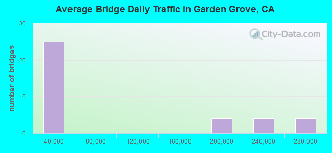
- 2,913,000Total average daily traffic
- 139,060Total average daily truck traffic
- National Bridge Inventory (NBI) Registered Bridges for Garden Grove
- No street view available for this location

- New bridges - historical statistics
- 11950-1959
- 281960-1969
- 11970-1979
- 62000-2009
- 12010-2019
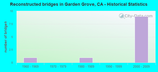
- Reconstructed bridges - Historical Statistics
- 11960-1969
- 01970-1979
- 11980-1989
- 01990-1999
- 92000-2009
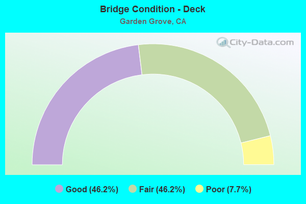
- Bridge Condition - Deck
- 46.2%Good
- 46.2%Fair
- 7.7%Poor
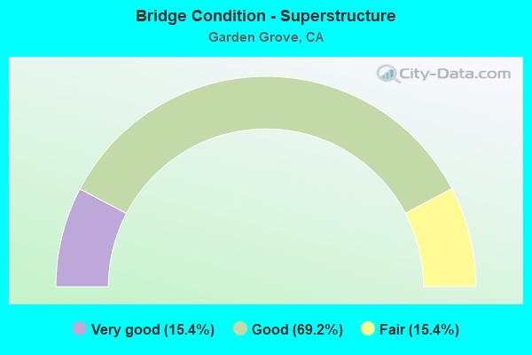
- Bridge Condition - Superstructure
- 15.4%Very good
- 69.2%Good
- 15.4%Fair
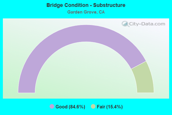
- Bridge Condition - Substructure
- 84.6%Good
- 15.4%Fair
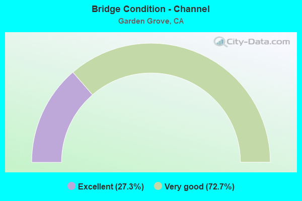
- Bridge Condition - Channel
- 27.3%Excellent
- 72.7%Very good
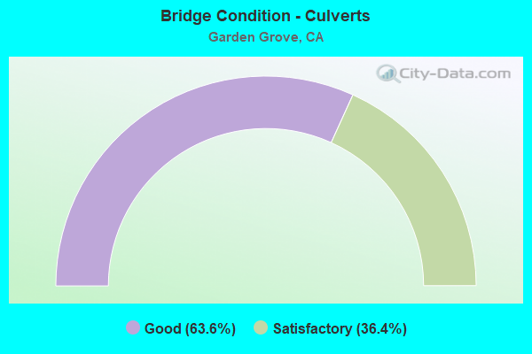
- Bridge Condition - Culverts
- 63.6%Good
- 36.4%Satisfactory
Find on map >> Show street view
Structure Number: 55 034, Location: 12-ORA-022-R9.73-ORA (Lat: 33.778681, Lng: -117.889272), Route carried "on" structure: State highway 22, Year Built: 1963, Year Reconstructed: 2007, Status: Open, Structure Length: 5.24m (17.19ft), Average Daily Traffic: 255,000 (year 2020), Truck Traffic: 5%, Average Future Daily Traffic: 285,575 (year 2038), Design Load: HS 20+Mod, Features Intersected: THE CITY DRIVE
Minimum Vertical Clearance: 30+ m (98+ ft), Kilometerpoint: 9.730, Lanes on structure: 12, Lanes under structure: 6, Base Highway Network: Yes (, Subroute: 1), Owner: State Highway Agency, Approaching Roadway Width: 67.2m (220.5ft), Skew: 31 degrees, Material/Design: Concrete continuous, Design/Construction: Box Beam or Girders - Multiple, Number Of Spans In Main Unit: 4, Length of Maximum Span: 16.8m (55.1ft), Curb-To-Curb Width: 67.2m (220.5ft), Out-to-Out Width: 69.0m (226.4ft)
Condition: Deck: Fair, Superstructure: Good, Substructure: Good, Operating Rating: 54.1 metric tons, Method Used To Determine Operating Rating: Assigned rating based on Load Factor Design (LFD) reported in metric tons, Inventory Rating: 32.4 metric tons, Method Used To Determine Inventory Rating: Assigned rating based on Load Factor Design (LFD) reported in metric tons, Structural Evaluation: Better than present minimum criteria, Deck Geometry: Superior to present desirable criteria, Underclear: Somewhat better than minimum adequacy, Approach Roadway Alignment: Equal to present desirable criteria, Designated Inspection Frequency: Every 24 months, Inspection Date: November 2020, Deck Structure Type: Concrete Cast-file-Place
Find on map >> Show street view
Structure Number: 55 0348, Location: 12-ORA-022-R4.22-GGR (Lat: 33.770083, Lng: -117.981419), Route carried "on" structure: State highway 22, Year Built: 1964, Year Reconstructed: 2007, Status: Open, Structure Length: 4.82m (15.81ft), Average Daily Traffic: 200,000 (year 2020), Truck Traffic: 5%, Average Future Daily Traffic: 205,000 (year 2038), Design Load: HS 20+Mod, Features Intersected: NEWLAND STREET
Minimum Vertical Clearance: 30+ m (98+ ft), Kilometerpoint: 4.220, Lanes on structure: 10, Lanes under structure: 3, Base Highway Network: Yes (, Subroute: 1), Owner: State Highway Agency, Approaching Roadway Width: 50.9m (167.0ft), Skew: 32 degrees, Material/Design: Concrete continuous, Design/Construction: Box Beam or Girders - Multiple, Number Of Spans In Main Unit: 3, Length of Maximum Span: 26.8m (87.9ft), Curb-To-Curb Width: 50.9m (167.0ft), Out-to-Out Width: 51.9m (170.3ft)
Condition: Deck: Fair, Superstructure: Good, Substructure: Good, Operating Rating: 54.1 metric tons, Method Used To Determine Operating Rating: Assigned rating based on Load Factor Design (LFD) reported in metric tons, Inventory Rating: 32.4 metric tons, Method Used To Determine Inventory Rating: Assigned rating based on Load Factor Design (LFD) reported in metric tons, Structural Evaluation: Better than present minimum criteria, Deck Geometry: Superior to present desirable criteria, Underclear: Equal to present minimum criteria, Approach Roadway Alignment: Better than present minimum criteria, Designated Inspection Frequency: Every 24 months, Inspection Date: April 2020, Deck Structure Type: Concrete Cast-file-Place
Find on map >> Show street view
Structure Number: 55 0363, Location: 12-ORA-022-R10.99-SA (Lat: 33.778528, Lng: -117.867483), Route carried "on" structure: City street M035, Year Built: 1963, Year Reconstructed: 1992, Status: Open, Structure Length: 5.64m (18.50ft), Average Daily Traffic: 22,000 (year 2020), Truck Traffic: 3%, Average Future Daily Traffic: 23,126 (year 2038), Design Load: HS 20+Mod, Features Intersected: STATE ROUTE 22, Facility Carried by Structure: MAIN ST
Minimum Vertical Clearance: 30+ m (98+ ft), Kilometerpoint: 0.000, Lanes on structure: 6, Lanes under structure: 10, Owner: State Highway Agency, Approaching Roadway Width: 21.8m (71.5ft), Skew: 20 degrees, Material/Design: Concrete continuous, Design/Construction: Box Beam or Girders - Multiple, Number Of Spans In Main Unit: 2, Length of Maximum Span: 27.4m (89.9ft), Curb or Sidewalk Widths: Left: 3.5m (11.5ft), Right: 1.5m (4.9ft), Curb-To-Curb Width: 21.8m (71.5ft), Out-to-Out Width: 32.3m (106.0ft)
Condition: Deck: Poor, Superstructure: Fair, Substructure: Fair, Operating Rating: 54.1 metric tons, Method Used To Determine Operating Rating: Assigned rating based on Load Factor Design (LFD) reported in metric tons, Inventory Rating: 32.4 metric tons, Method Used To Determine Inventory Rating: Assigned rating based on Load Factor Design (LFD) reported in metric tons, Structural Evaluation: Somewhat better than minimum adequacy, Deck Geometry: High priority of replacement, Underclear: High priority of corrective action, Approach Roadway Alignment: Better than present minimum criteria, Length Of Structure Improvement: 5.64m (18.50ft), Designated Inspection Frequency: Every 24 months, Inspection Date: November 2020, Bridge Improvement Cost: $1,765,000, Roadway Improvement Cost: $353,000, Total Project Cost: $2,965,000 ( Estimate for 2017), Deck Structure Type: Concrete Cast-file-Place
Find on map >> Show street view
Structure Number: 55 0366, Location: 12-ORA-022-R2.69-GGR (Lat: 33.774206, Lng: -118.007733), Route carried "on" structure: State highway 22, Year Built: 1966, Year Reconstructed: 2007, Status: Open, Structure Length: 6.44m (21.13ft), Average Daily Traffic: 160,000 (year 2020), Truck Traffic: 9%, Average Future Daily Traffic: 200,000 (year 2038), Design Load: HS 20+Mod, Features Intersected: KNOTT AVE
Minimum Vertical Clearance: 30+ m (98+ ft), Kilometerpoint: 2.690, Lanes on structure: 8, Lanes under structure: 5, Base Highway Network: Yes (, Subroute: 1), Owner: State Highway Agency, Approaching Roadway Width: 43.7m (143.4ft), Skew: 32 degrees, Material/Design: Concrete continuous, Design/Construction: Box Beam or Girders - Multiple, Number Of Spans In Main Unit: 4, Length of Maximum Span: 22.2m (72.8ft), Curb-To-Curb Width: 43.7m (143.4ft), Out-to-Out Width: 44.7m (146.7ft)
Condition: Deck: Fair, Superstructure: Good, Substructure: Good, Operating Rating: 27.5 metric tons, Method Used To Determine Operating Rating: Load Factor (LF), Inventory Rating: 26.9 metric tons, Method Used To Determine Inventory Rating: Load Factor (LF), Structural Evaluation: Equal to present minimum criteria, Deck Geometry: Superior to present desirable criteria, Underclear: Meets minimum limits, Approach Roadway Alignment: Better than present minimum criteria, Designated Inspection Frequency: Every 24 months, Inspection Date: April 2020, Deck Structure Type: Concrete Cast-file-Place
Find on map >> Show street view
Structure Number: 55 0367, Location: 12-ORA-022-R2.74-GGR (Lat: 33.773969, Lng: -118.006922), Route carried "on" structure: State highway 22, Year Built: 1966, Year Reconstructed: 2007, Status: Open, Structure Length: 11.80m (38.71ft), Average Daily Traffic: 250,000 (year 2020), Truck Traffic: 9%, Average Future Daily Traffic: 373,000 (year 2038), Design Load: HS 20+Mod, Features Intersected: GARDEN GROVE BLVD
Minimum Vertical Clearance: 30+ m (98+ ft), Kilometerpoint: 2.740, Lanes on structure: 8, Lanes under structure: 6, Base Highway Network: Yes (, Subroute: 1), Owner: State Highway Agency, Approaching Roadway Width: 43.7m (143.4ft), Skew: 35 degrees, Material/Design: Concrete continuous, Design/Construction: Box Beam or Girders - Multiple, Number Of Spans In Main Unit: 4, Length of Maximum Span: 36.9m (121.1ft), Curb-To-Curb Width: 43.7m (143.4ft), Out-to-Out Width: 44.7m (146.7ft)
Condition: Deck: Fair, Superstructure: Good, Substructure: Good, Operating Rating: 54.1 metric tons, Method Used To Determine Operating Rating: Assigned rating based on Load Factor Design (LFD) reported in metric tons, Inventory Rating: 32.4 metric tons, Method Used To Determine Inventory Rating: Assigned rating based on Load Factor Design (LFD) reported in metric tons, Structural Evaluation: Better than present minimum criteria, Deck Geometry: Superior to present desirable criteria, Underclear: Meets minimum limits, Approach Roadway Alignment: Better than present minimum criteria, Designated Inspection Frequency: Every 24 months, Inspection Date: April 2020, Deck Structure Type: Concrete Cast-file-Place
Find on map >> Show street view
Structure Number: 55 0369, Location: 12-ORA-022-R4.53-GGR (Lat: 33.767433, Lng: -117.977017), Route carried "on" structure: State highway 22, Year Built: 1965, Year Reconstructed: 2007, Status: Open, Structure Length: 5.67m (18.60ft), Average Daily Traffic: 185,000 (year 2020), Truck Traffic: 5%, Average Future Daily Traffic: 205,000 (year 2037), Design Load: HS 20+Mod, Features Intersected: YOCKEY STREET
Minimum Vertical Clearance: 30+ m (98+ ft), Kilometerpoint: 4.530, Lanes on structure: 10, Lanes under structure: 2, Base Highway Network: Yes (, Subroute: 1), Owner: State Highway Agency, Approaching Roadway Width: 61.1m (200.5ft), Skew: 34 degrees, Material/Design: Concrete continuous, Design/Construction: Box Beam or Girders - Multiple, Number Of Spans In Main Unit: 3, Length of Maximum Span: 26.5m (86.9ft), Curb-To-Curb Width: 61.1m (200.5ft), Out-to-Out Width: 62.1m (203.7ft)
Condition: Deck: Good, Superstructure: Good, Substructure: Good, Operating Rating: 54.1 metric tons, Method Used To Determine Operating Rating: Assigned rating based on Load Factor Design (LFD) reported in metric tons, Inventory Rating: 32.4 metric tons, Method Used To Determine Inventory Rating: Assigned rating based on Load Factor Design (LFD) reported in metric tons, Structural Evaluation: Better than present minimum criteria, Deck Geometry: Superior to present desirable criteria, Underclear: Better than present minimum criteria, Approach Roadway Alignment: Better than present minimum criteria, Designated Inspection Frequency: Every 48 months, Inspection Date: April 2020, Deck Structure Type: Concrete Cast-file-Place, Wearing Surface/Protective System: Wearing Surface: Integral Concrete
Find on map >> Show street view
Structure Number: 55 0372, Location: 12-ORA-022-R6.57-GGR (Lat: 33.765786, Lng: -117.942272), Route carried "on" structure: State highway 22, Year Built: 1965, Year Reconstructed: 2007, Status: Open, Structure Length: 3.60m (11.81ft), Average Daily Traffic: 200,000 (year 2020), Average Future Daily Traffic: 291,000 (year 2038), Design Load: HS 20+Mod, Features Intersected: TAFT STREET
Minimum Vertical Clearance: 30+ m (98+ ft), Kilometerpoint: 6.570, Lanes on structure: 10, Lanes under structure: 2, Base Highway Network: Yes (, Subroute: 1), Owner: State Highway Agency, Approaching Roadway Width: 50.9m (167.0ft), Skew: 30 degrees, Material/Design: Concrete continuous, Design/Construction: Box Beam or Girders - Multiple, Number Of Spans In Main Unit: 3, Length of Maximum Span: 18.9m (62.0ft), Curb-To-Curb Width: 50.9m (167.0ft), Out-to-Out Width: 51.9m (170.3ft)
Condition: Deck: Good, Superstructure: Good, Substructure: Good, Operating Rating: 54.1 metric tons, Method Used To Determine Operating Rating: Assigned rating based on Load Factor Design (LFD) reported in metric tons, Inventory Rating: 32.4 metric tons, Method Used To Determine Inventory Rating: Assigned rating based on Load Factor Design (LFD) reported in metric tons, Structural Evaluation: Better than present minimum criteria, Deck Geometry: Superior to present desirable criteria, Underclear: Equal to present minimum criteria, Approach Roadway Alignment: Equal to present desirable criteria, Designated Inspection Frequency: Every 48 months, Inspection Date: April 2020, Deck Structure Type: Concrete Cast-file-Place
Find on map >> Show street view
Structure Number: 55 0374, Location: 12-ORA-022-R7.31-GGR (Lat: 33.765878, Lng: -117.929344), Route carried "on" structure: State highway 22, Year Built: 1965, Year Reconstructed: 2007, Status: Open, Structure Length: 12.16m (39.90ft), Average Daily Traffic: 255,000 (year 2020), Truck Traffic: 5%, Average Future Daily Traffic: 291,000 (year 2038), Design Load: HS 20+Mod, Features Intersected: NEWHOPE STREET
Minimum Vertical Clearance: 9.10m (29.86ft), Kilometerpoint: 7.310, Lanes on structure: 10, Lanes under structure: 5, Base Highway Network: Yes (, Subroute: 1), Owner: State Highway Agency, Approaching Roadway Width: 50.9m (167.0ft), Skew: 30 degrees, Material/Design: Concrete continuous, Design/Construction: Box Beam or Girders - Multiple, Number Of Spans In Main Unit: 5, Length of Maximum Span: 34.7m (113.8ft), Curb-To-Curb Width: 50.9m (167.0ft), Out-to-Out Width: 51.9m (170.3ft)
Condition: Deck: Good, Superstructure: Good, Substructure: Fair, Operating Rating: 54.1 metric tons, Method Used To Determine Operating Rating: Assigned rating based on Load Factor Design (LFD) reported in metric tons, Inventory Rating: 32.4 metric tons, Method Used To Determine Inventory Rating: Assigned rating based on Load Factor Design (LFD) reported in metric tons, Structural Evaluation: Somewhat better than minimum adequacy, Deck Geometry: Superior to present desirable criteria, Underclear: Meets minimum limits, Approach Roadway Alignment: Equal to present desirable criteria, Designated Inspection Frequency: Every 24 months, Inspection Date: April 2020, Deck Structure Type: Concrete Cast-file-Place, Wearing Surface/Protective System: Wearing Surface: Integral Concrete
Find on map >> Show street view
Structure Number: 55 0375, Location: 12-ORA-022-R7.68-GGR (Lat: 33.766864, Lng: -117.922331), Route carried "on" structure: State highway 22, Year Built: 1965, Year Reconstructed: 2007, Status: Open, Structure Length: 12.20m (40.03ft), Average Daily Traffic: 220,000 (year 2020), Truck Traffic: 5%, Average Future Daily Traffic: 234,000 (year 2038), Design Load: HS 20+Mod, Features Intersected: TRASK AVE
Minimum Vertical Clearance: 30+ m (98+ ft), Kilometerpoint: 7.680, Lanes on structure: 11, Lanes under structure: 4, Base Highway Network: Yes (, Subroute: 1), Owner: State Highway Agency, Approaching Roadway Width: 56.5m (185.4ft), Skew: 36 degrees, Material/Design: Concrete continuous, Design/Construction: Box Beam or Girders - Multiple, Number Of Spans In Main Unit: 4, Length of Maximum Span: 34.7m (113.8ft), Curb-To-Curb Width: 56.5m (185.4ft), Out-to-Out Width: 57.5m (188.6ft)
Condition: Deck: Good, Superstructure: Good, Substructure: Good, Operating Rating: 54.1 metric tons, Method Used To Determine Operating Rating: Assigned rating based on Load Factor Design (LFD) reported in metric tons, Inventory Rating: 32.4 metric tons, Method Used To Determine Inventory Rating: Assigned rating based on Load Factor Design (LFD) reported in metric tons, Structural Evaluation: Better than present minimum criteria, Deck Geometry: Superior to present desirable criteria, Underclear: Somewhat better than minimum adequacy, Approach Roadway Alignment: Equal to present desirable criteria, Designated Inspection Frequency: Every 24 months, Inspection Date: April 2020, Deck Structure Type: Concrete Cast-file-Place, Wearing Surface/Protective System: Wearing Surface: Integral Concrete
Find on map >> Show street view
Structure Number: 55 0378, Location: 12-ORA-022-R8.82-GGR (Lat: 33.774208, Lng: -117.904800), Route carried "on" structure: State highway 22, Year Built: 1965, Year Reconstructed: 2007, Status: Open, Structure Length: 10.35m (33.96ft), Average Daily Traffic: 260,000 (year 2020), Truck Traffic: 5%, Average Future Daily Traffic: 263,141 (year 2040), Design Load: HS 20+Mod, Features Intersected: GARDEN GROVE BLVD
Minimum Vertical Clearance: 30+ m (98+ ft), Kilometerpoint: 8.820, Lanes on structure: 10, Lanes under structure: 6, Base Highway Network: Yes (, Subroute: 1), Owner: State Highway Agency, Approaching Roadway Width: 50.9m (167.0ft), Skew: 35 degrees, Material/Design: Concrete continuous, Design/Construction: Box Beam or Girders - Multiple, Number Of Spans In Main Unit: 4, Length of Maximum Span: 33.2m (108.9ft), Curb-To-Curb Width: 50.9m (167.0ft), Out-to-Out Width: 51.9m (170.3ft)
Condition: Deck: Fair, Superstructure: Good, Substructure: Good, Operating Rating: 43.4 metric tons, Method Used To Determine Operating Rating: Load and Resistance Factor Rating (LRFR) rating reported by rating factor(RF) method using HL-93 loadings, Inventory Rating: 31.4 metric tons, Method Used To Determine Inventory Rating: Load and Resistance Factor Rating (LRFR) rating reported by rating factor(RF) method using HL-93 loadings, Structural Evaluation: Better than present minimum criteria, Deck Geometry: Superior to present desirable criteria, Underclear: High priority of corrective action, Approach Roadway Alignment: Equal to present desirable criteria, Designated Inspection Frequency: Every 24 months, Inspection Date: April 2020, Deck Structure Type: Concrete Cast-file-Place
Find on map >> Show street view
Structure Number: 55 107, Location: 12-ORA-005-44.24 (Lat: 33.873272, Lng: -118.009131), Route carried "on" structure: Interstate 5, Year Built: 2010, Status: Open, Structure Length: 6.95m (22.80ft), Average Daily Traffic: 171,000 (year 2016), Truck Traffic: 9%, Average Future Daily Traffic: 215,434 (year 2042), Design Load: HS 20+Mod, Features Intersected: ARTESIA BLVD
Minimum Vertical Clearance: 30+ m (98+ ft), Kilometerpoint: 44.240, Lanes on structure: 10, Lanes under structure: 6, Base Highway Network: Yes (, Subroute: 1), Owner: State Highway Agency, Approaching Roadway Width: 40.5m (132.9ft), Skew: 4 degrees, Material/Design: Concrete continuous, Design/Construction: Box Beam or Girders - Multiple, Number Of Spans In Main Unit: 2, Length of Maximum Span: 37.5m (123.0ft), Curb-To-Curb Width: 40.5m (132.9ft), Out-to-Out Width: 68.5m (224.7ft)
Condition: Deck: Fair, Superstructure: Fair, Substructure: Good, Operating Rating: 54.1 metric tons, Method Used To Determine Operating Rating: Assigned rating based on Load Factor Design (LFD) reported in metric tons, Inventory Rating: 32.4 metric tons, Method Used To Determine Inventory Rating: Assigned rating based on Load Factor Design (LFD) reported in metric tons, Structural Evaluation: Somewhat better than minimum adequacy, Deck Geometry: Meets minimum limits, Underclear: Somewhat better than minimum adequacy, Approach Roadway Alignment: Equal to present desirable criteria, Designated Inspection Frequency: Every 24 months, Inspection Date: Febuary 2022, Deck Structure Type: Concrete Cast-file-Place
Find on map >> Show street view
Structure Number: 55 1079, Location: 12-ORA-022-R5.82-GGR (Lat: 33.765589, Lng: -117.955272), Route carried "on" structure: State highway 22, Year Built: 2007, Status: Open, Structure Length: 4.30m (14.11ft), Average Daily Traffic: 215,000 (year 2020), Average Future Daily Traffic: 291,000 (year 2038), Design Load: HS 20+Mod, Features Intersected: BROOKHURST STREET
Minimum Vertical Clearance: 30+ m (98+ ft), Kilometerpoint: 5.820, Lanes on structure: 11, Lanes under structure: 8, Base Highway Network: Yes (, Subroute: 1), Owner: State Highway Agency, Approaching Roadway Width: 56.5m (185.4ft), Skew: 30 degrees, Material/Design: Concrete continuous, Design/Construction: Stringer/Multi-beam, Number Of Spans In Main Unit: 2, Length of Maximum Span: 21.5m (70.5ft), Curb-To-Curb Width: 56.5m (185.4ft), Out-to-Out Width: 58.0m (190.3ft)
Condition: Deck: Good, Superstructure: Very good, Substructure: Good, Operating Rating: 54.1 metric tons, Method Used To Determine Operating Rating: Assigned rating based on Load Factor Design (LFD) reported in metric tons, Inventory Rating: 32.4 metric tons, Method Used To Determine Inventory Rating: Assigned rating based on Load Factor Design (LFD) reported in metric tons, Structural Evaluation: Better than present minimum criteria, Deck Geometry: Superior to present desirable criteria, Underclear: High priority of corrective action, Approach Roadway Alignment: Equal to present desirable criteria, Designated Inspection Frequency: Every 48 months, Inspection Date: April 2020, Deck Structure Type: Concrete Cast-file-Place
Find on map >> Show street view
Structure Number: 55 1092, Location: 12-ORA-022-R4.81-GGR (Lat: 33.765633, Lng: -117.972694), Route carried "on" structure: State highway 22, Year Built: 2007, Status: Open, Structure Length: 4.55m (14.93ft), Average Daily Traffic: 186,000 (year 2020), Truck Traffic: 5%, Average Future Daily Traffic: 205,000 (year 2038), Design Load: HS 20+Mod, Features Intersected: MAGNOLIA STREET
Minimum Vertical Clearance: 30+ m (98+ ft), Kilometerpoint: 4.810, Lanes on structure: 10, Lanes under structure: 7, Base Highway Network: Yes (, Subroute: 1), Owner: State Highway Agency, Approaching Roadway Width: 50.9m (167.0ft), Skew: 30 degrees, Material/Design: Concrete, Design/Construction: Stringer/Multi-beam, Number Of Spans In Main Unit: 2, Length of Maximum Span: 23.8m (78.1ft), Curb-To-Curb Width: 50.9m (167.0ft), Out-to-Out Width: 51.9m (170.3ft)
Condition: Deck: Good, Superstructure: Very good, Substructure: Good, Operating Rating: 54.1 metric tons, Method Used To Determine Operating Rating: Assigned rating based on Load Factor Design (LFD) reported in metric tons, Inventory Rating: 32.4 metric tons, Method Used To Determine Inventory Rating: Assigned rating based on Load Factor Design (LFD) reported in metric tons, Structural Evaluation: Better than present minimum criteria, Deck Geometry: Superior to present desirable criteria, Underclear: Equal to present minimum criteria, Approach Roadway Alignment: Equal to present desirable criteria, Designated Inspection Frequency: Every 48 months, Inspection Date: April 2020, Deck Structure Type: Concrete Cast-file-Place
Find on map >> Show street view
Structure Number: 55C0091, Location: 0.15 MI N/O ORANGEWOOD AV (Lat: 33.797728, Lng: -117.958519), Route carried "on" structure: City street , Year Built: 1963, Year Reconstructed: 1974, Status: Open, Structure Length: 0.67m (2.20ft), Average Daily Traffic: 29,000 (year 2014), Truck Traffic: 1%, Average Future Daily Traffic: 77,789 (year 2040), Features Intersected: ANAHEIM BARBER CITY CHAN, Facility Carried by Structure: BROOKHURST STREET
Minimum Vertical Clearance: 30+ m (98+ ft), Kilometerpoint: 0.000, Lanes on structure: 6, Base Highway Network: Yes, Owner: City or Municipal Highway Agency, Approaching Roadway Width: 32.8m (107.6ft), Skew: 30 degrees, Material/Design: Concrete, Design/Construction: Culvert, Number Of Spans In Main Unit: 2, Length of Maximum Span: 3.0m (9.8ft), Curb or Sidewalk Widths: Left: 2.4m (7.9ft), Right: 2.4m (7.9ft), Curb-To-Curb Width: 32.8m (107.6ft), Out-to-Out Width: 43.3m (142.1ft)
Condition: Channel: Very good, Culverts: Good, Operating Rating: 40.5 metric tons, Method Used To Determine Operating Rating: Field evaluation and documented engineering judgment, Inventory Rating: 24.3 metric tons, Method Used To Determine Inventory Rating: Field evaluation and documented engineering judgment, Structural Evaluation: Equal to present minimum criteria, Deck Geometry: Superior to present desirable criteria, Waterway Adequacy: Equal to present desirable criteria, Approach Roadway Alignment: Equal to present desirable criteria, Designated Inspection Frequency: Every 24 months, Inspection Date: May 2020, Deck Structure Type: Concrete Cast-file-Place, Wearing Surface/Protective System: Wearing Surface: Bituminous
Find on map >> Show street view
Structure Number: 55C0401, Location: 100' N/W RANCHO RD (Lat: 33.753350, Lng: -118.038044), Route carried "on" structure: City street , Year Built: 1973, Status: Open, Structure Length: 2.13m (6.99ft), Average Daily Traffic: 1,000 (year 2021), Truck Traffic: 1%, Average Future Daily Traffic: 1,069 (year 2039), Features Intersected: ANHM BARBER CITY CHANNEL, Facility Carried by Structure: SUFFOLK ST
Minimum Vertical Clearance: 30+ m (98+ ft), Kilometerpoint: 0.000, Lanes on structure: 2, Owner: City or Municipal Highway Agency, Approaching Roadway Width: 12.2m (40.0ft), Material/Design: Concrete, Design/Construction: Culvert, Number Of Spans In Main Unit: 5, Length of Maximum Span: 4.0m (13.1ft), Curb or Sidewalk Widths: Left: 1.8m (5.9ft), Right: 1.8m (5.9ft), Curb-To-Curb Width: 12.2m (40.0ft), Out-to-Out Width: 16.2m (53.1ft)
Condition: Channel: Very good, Culverts: Good, Operating Rating: 54.1 metric tons, Method Used To Determine Operating Rating: Field evaluation and documented engineering judgment, Inventory Rating: 32.4 metric tons, Method Used To Determine Inventory Rating: Field evaluation and documented engineering judgment, Structural Evaluation: Better than present minimum criteria, Deck Geometry: Equal to present desirable criteria, Waterway Adequacy: Equal to present desirable criteria, Approach Roadway Alignment: Equal to present desirable criteria, Designated Inspection Frequency: Every 48 months, Inspection Date: April 2021, Deck Structure Type: Concrete Cast-file-Place, Wearing Surface/Protective System: Wearing Surface: Bituminous
Find on map >> Show street view
Structure Number: 55C0403, Location: 0.3 M N/O GARDEN GROVE BL (Lat: 33.778536, Lng: -118.001253), Route carried "on" structure: City street , Year Built: 1964, Status: Open, Structure Length: 1.13m (3.71ft), Average Daily Traffic: 16,500 (year 2015), Truck Traffic: 2%, Average Future Daily Traffic: 31,430 (year 2037), Features Intersected: ANAHEIM-BARBER CITY CHA, Facility Carried by Structure: WESTERN AVENUE
Minimum Vertical Clearance: 30+ m (98+ ft), Kilometerpoint: 0.000, Lanes on structure: 5, Owner: City or Municipal Highway Agency, Approaching Roadway Width: 19.4m (63.6ft), Skew: 4 degrees, Material/Design: Concrete, Design/Construction: Culvert, Number Of Spans In Main Unit: 2, Length of Maximum Span: 5.2m (17.1ft), Curb or Sidewalk Widths: Left: 0.2m (0.7ft), Right: 0.2m (0.7ft), Curb-To-Curb Width: 19.4m (63.6ft), Out-to-Out Width: 23.3m (76.4ft)
Condition: Channel: Very good, Culverts: Good, Operating Rating: 40.5 metric tons, Method Used To Determine Operating Rating: Field evaluation and documented engineering judgment, Inventory Rating: 24.3 metric tons, Method Used To Determine Inventory Rating: Field evaluation and documented engineering judgment, Structural Evaluation: Equal to present minimum criteria, Deck Geometry: Meets minimum limits, Waterway Adequacy: Equal to present desirable criteria, Approach Roadway Alignment: Equal to present desirable criteria, Designated Inspection Frequency: Every 24 months, Inspection Date: May 2020, Deck Structure Type: Concrete Cast-file-Place, Wearing Surface/Protective System: Wearing Surface: Bituminous
Find on map >> Show street view
Structure Number: 55C0404, Location: 0.1 MI N/O CHAPMAN AVENUE (Lat: 33.790014, Lng: -117.984064), Route carried "on" structure: County highway , Year Built: 1959, Status: Open, Structure Length: 1.01m (3.31ft), Average Daily Traffic: 16,000 (year 2021), Truck Traffic: 1%, Average Future Daily Traffic: 20,791 (year 2039), Features Intersected: ANAHEIM-BARBER CITY CHA, Facility Carried by Structure: DALE STREET
Minimum Vertical Clearance: 30+ m (98+ ft), Kilometerpoint: 0.000, Lanes on structure: 3, Owner: County Highway Agency, Approaching Roadway Width: 15.2m (49.9ft), Skew: 3 degrees, Material/Design: Concrete, Design/Construction: Culvert, Number Of Spans In Main Unit: 2, Length of Maximum Span: 3.7m (12.1ft), Curb or Sidewalk Widths: Left: 2.5m (8.2ft), Right: 1.2m (3.9ft), Curb-To-Curb Width: 14.9m (48.9ft), Out-to-Out Width: 24.4m (80.1ft)
Condition: Channel: Excellent, Culverts: Good, Operating Rating: 40.5 metric tons, Method Used To Determine Operating Rating: Field evaluation and documented engineering judgment, Inventory Rating: 24.3 metric tons, Method Used To Determine Inventory Rating: Field evaluation and documented engineering judgment, Structural Evaluation: Equal to present minimum criteria, Deck Geometry: Equal to present minimum criteria, Waterway Adequacy: Superior to present desirable criteria, Approach Roadway Alignment: Equal to present desirable criteria, Designated Inspection Frequency: Every 24 months, Inspection Date: July 2021
Find on map >> Show street view
Structure Number: 55C0405, Location: 0.3 MI N/O CHAPMAN AVE (Lat: 33.792411, Lng: -117.980408), Route carried "on" structure: City street , Year Built: 1963, Status: Open, Structure Length: 0.73m (2.40ft), Average Daily Traffic: 1,000 (year 2014), Truck Traffic: 2%, Average Future Daily Traffic: 523 (year 2037), Design Load: HS 20, Features Intersected: ANAHEIM-BARBER CITY CHAN, Facility Carried by Structure: MAC DUFF STREET
Minimum Vertical Clearance: 30+ m (98+ ft), Kilometerpoint: 0.000, Lanes on structure: 2, Owner: City or Municipal Highway Agency, Approaching Roadway Width: 10.8m (35.4ft), Material/Design: Concrete, Design/Construction: Culvert, Number Of Spans In Main Unit: 2, Length of Maximum Span: 3.4m (11.2ft), Curb or Sidewalk Widths: Left: 0.2m (0.7ft), Right: 0.2m (0.7ft), Curb-To-Curb Width: 10.8m (35.4ft), Out-to-Out Width: 15.2m (49.9ft)
Condition: Channel: Very good, Culverts: Satisfactory, Operating Rating: 54.1 metric tons, Method Used To Determine Operating Rating: Field evaluation and documented engineering judgment, Inventory Rating: 32.4 metric tons, Method Used To Determine Inventory Rating: Field evaluation and documented engineering judgment, Structural Evaluation: Equal to present minimum criteria, Deck Geometry: Equal to present minimum criteria, Waterway Adequacy: Equal to present desirable criteria, Approach Roadway Alignment: Equal to present minimum criteria, Designated Inspection Frequency: Every 48 months, Inspection Date: May 2020, Deck Structure Type: Concrete Cast-file-Place
Find on map >> Show street view
Structure Number: 55C0406, Location: 0.15 MI N/O ORANGEWOOD AV (Lat: 33.797692, Lng: -117.967436), Route carried "on" structure: City street , Year Built: 1963, Status: Open, Structure Length: 0.67m (2.20ft), Average Daily Traffic: 11,500 (year 2014), Truck Traffic: 2%, Average Future Daily Traffic: 27,241 (year 2037), Design Load: HS 20, Features Intersected: ANAHEIM-BARBER CITY CHAN, Facility Carried by Structure: GILBERT STREET
Minimum Vertical Clearance: 30+ m (98+ ft), Kilometerpoint: 0.000, Lanes on structure: 4, Owner: City or Municipal Highway Agency, Approaching Roadway Width: 19.2m (63.0ft), Material/Design: Concrete, Design/Construction: Culvert, Number Of Spans In Main Unit: 2, Length of Maximum Span: 3.0m (9.8ft), Curb or Sidewalk Widths: Left: 2.4m (7.9ft), Right: 2.3m (7.5ft), Curb-To-Curb Width: 19.2m (63.0ft), Out-to-Out Width: 23.9m (78.4ft)
Condition: Channel: Very good, Culverts: Satisfactory, Operating Rating: 54.1 metric tons, Method Used To Determine Operating Rating: Field evaluation and documented engineering judgment, Inventory Rating: 32.4 metric tons, Method Used To Determine Inventory Rating: Field evaluation and documented engineering judgment, Structural Evaluation: Equal to present minimum criteria, Deck Geometry: Equal to present minimum criteria, Waterway Adequacy: Equal to present desirable criteria, Approach Roadway Alignment: Equal to present desirable criteria, Designated Inspection Frequency: Every 48 months, Inspection Date: May 2020, Deck Structure Type: Concrete Cast-file-Place, Wearing Surface/Protective System: Wearing Surface: Bituminous
Find on map >> Show street view
Structure Number: 55C0407, Location: 0.15 MI N/O ORANGEWOOD AV (Lat: 33.797706, Lng: -117.963686), Route carried "on" structure: City street , Year Built: 1963, Status: Open, Structure Length: 0.67m (2.20ft), Average Daily Traffic: 1,000 (year 2014), Truck Traffic: 2%, Average Future Daily Traffic: 523 (year 2037), Design Load: HS 20, Features Intersected: ANAHEIM-BARBER CITY CHAN, Facility Carried by Structure: BARCLAY DRIVE
Minimum Vertical Clearance: 30+ m (98+ ft), Kilometerpoint: 0.000, Lanes on structure: 2, Owner: City or Municipal Highway Agency, Approaching Roadway Width: 10.8m (35.4ft), Material/Design: Concrete, Design/Construction: Culvert, Number Of Spans In Main Unit: 2, Length of Maximum Span: 3.0m (9.8ft), Curb or Sidewalk Widths: Left: 0.2m (0.7ft), Right: 0.2m (0.7ft), Curb-To-Curb Width: 10.8m (35.4ft), Out-to-Out Width: 15.2m (49.9ft)
Condition: Channel: Very good, Culverts: Satisfactory, Operating Rating: 54.1 metric tons, Method Used To Determine Operating Rating: Field evaluation and documented engineering judgment, Inventory Rating: 32.4 metric tons, Method Used To Determine Inventory Rating: Field evaluation and documented engineering judgment, Structural Evaluation: Equal to present minimum criteria, Deck Geometry: Equal to present minimum criteria, Waterway Adequacy: Equal to present desirable criteria, Approach Roadway Alignment: Equal to present desirable criteria, Designated Inspection Frequency: Every 48 months, Inspection Date: May 2020, Deck Structure Type: Concrete Cast-file-Place, Wearing Surface/Protective System: Wearing Surface: Bituminous
Find on map >> Show street view
Structure Number: 55C0408, Location: AT ORANGEWOOD AVENUE (Lat: 33.795892, Lng: -117.975103), Route carried "on" structure: City street , Year Built: 1963, Status: Open, Structure Length: 1.20m (3.94ft), Average Daily Traffic: 24,000 (year 2014), Truck Traffic: 1%, Average Future Daily Traffic: 43,857 (year 2037), Design Load: HS 20, Features Intersected: ANAHEIM-BARBER CITY CHAN, Facility Carried by Structure: MAGNOLIA STREET
Minimum Vertical Clearance: 30+ m (98+ ft), Kilometerpoint: 0.000, Lanes on structure: 5, Base Highway Network: Yes, Owner: City or Municipal Highway Agency, Approaching Roadway Width: 23.9m (78.4ft), Skew: 35 degrees, Material/Design: Concrete, Design/Construction: Culvert, Number Of Spans In Main Unit: 2, Length of Maximum Span: 5.5m (18.0ft), Curb or Sidewalk Widths: Left: 2.2m (7.2ft), Right: 2.4m (7.9ft), Curb-To-Curb Width: 23.9m (78.4ft), Out-to-Out Width: 30.6m (100.4ft)
Condition: Channel: Very good, Culverts: Good, Operating Rating: 54.1 metric tons, Method Used To Determine Operating Rating: Field evaluation and documented engineering judgment, Inventory Rating: 32.4 metric tons, Method Used To Determine Inventory Rating: Field evaluation and documented engineering judgment, Structural Evaluation: Better than present minimum criteria, Deck Geometry: Better than present minimum criteria, Waterway Adequacy: Equal to present desirable criteria, Approach Roadway Alignment: Equal to present desirable criteria, Designated Inspection Frequency: Every 48 months, Inspection Date: May 2020
Find on map >> Show street view
Structure Number: 55C0409, Location: 0.15 MI N/O ORANGEWOOD AV (Lat: 33.797719, Lng: -117.959867), Route carried "on" structure: City street , Year Built: 1963, Status: Open, Structure Length: 0.67m (2.20ft), Average Daily Traffic: 500 (year 2014), Truck Traffic: 2%, Average Future Daily Traffic: 1,049 (year 2037), Design Load: HS 20, Features Intersected: ANAHEIM-BARBER CITY CHAN, Facility Carried by Structure: BISCAYNE BLVD
Minimum Vertical Clearance: 30+ m (98+ ft), Kilometerpoint: 0.000, Lanes on structure: 2, Owner: City or Municipal Highway Agency, Approaching Roadway Width: 10.8m (35.4ft), Material/Design: Concrete, Design/Construction: Culvert, Number Of Spans In Main Unit: 2, Length of Maximum Span: 3.0m (9.8ft), Curb or Sidewalk Widths: Left: 0.2m (0.7ft), Right: 0.2m (0.7ft), Curb-To-Curb Width: 10.8m (35.4ft), Out-to-Out Width: 18.2m (59.7ft)
Condition: Channel: Excellent, Culverts: Satisfactory, Operating Rating: 54.1 metric tons, Method Used To Determine Operating Rating: Field evaluation and documented engineering judgment, Inventory Rating: 32.4 metric tons, Method Used To Determine Inventory Rating: Field evaluation and documented engineering judgment, Structural Evaluation: Equal to present minimum criteria, Deck Geometry: Equal to present minimum criteria, Waterway Adequacy: Superior to present desirable criteria, Approach Roadway Alignment: Equal to present desirable criteria, Designated Inspection Frequency: Every 48 months, Inspection Date: May 2020, Deck Structure Type: Concrete Cast-file-Place, Wearing Surface/Protective System: Wearing Surface: Bituminous
Find on map >> Show street view
Structure Number: 55C0411, Location: 0.1 MI N/O ORANGEWOOD AVE (Lat: 33.797758, Lng: -117.949558), Route carried "on" structure: City street , Year Built: 1963, Status: Open, Structure Length: 0.67m (2.20ft), Average Daily Traffic: 1,000 (year 2015), Truck Traffic: 2%, Average Future Daily Traffic: 2,109 (year 2037), Features Intersected: ANAHEIM-BARBER CITY CHAN, Facility Carried by Structure: PALMWOOD DRIVE
Minimum Vertical Clearance: 30+ m (98+ ft), Kilometerpoint: 0.000, Lanes on structure: 2, Owner: City or Municipal Highway Agency, Approaching Roadway Width: 10.8m (35.4ft), Material/Design: Concrete, Design/Construction: Culvert, Number Of Spans In Main Unit: 2, Length of Maximum Span: 3.0m (9.8ft), Curb or Sidewalk Widths: Left: 1.2m (3.9ft), Right: 1.2m (3.9ft), Curb-To-Curb Width: 10.8m (35.4ft), Out-to-Out Width: 18.2m (59.7ft)
Condition: Channel: Excellent, Culverts: Good, Operating Rating: 40.5 metric tons, Method Used To Determine Operating Rating: Field evaluation and documented engineering judgment, Inventory Rating: 24.3 metric tons, Method Used To Determine Inventory Rating: Field evaluation and documented engineering judgment, Structural Evaluation: Equal to present minimum criteria, Deck Geometry: Equal to present minimum criteria, Waterway Adequacy: Superior to present desirable criteria, Approach Roadway Alignment: Equal to present desirable criteria, Designated Inspection Frequency: Every 24 months, Inspection Date: May 2020, Deck Structure Type: Concrete Cast-file-Place, Wearing Surface/Protective System: Wearing Surface: Bituminous
Find on map >> Show street view
Structure Number: 55C0412, Location: 0.25 MI E/O EUCLID STREET (Lat: 33.798950, Lng: -117.938036), Route carried "on" structure: City street , Year Built: 1963, Status: Open, Structure Length: 1.01m (3.31ft), Average Daily Traffic: 500 (year 2015), Truck Traffic: 2%, Average Future Daily Traffic: 1,056 (year 2037), Features Intersected: ANAHEIM-BARBER CITY CHAN, Facility Carried by Structure: WAKEFIELD AVENUE
Minimum Vertical Clearance: 30+ m (98+ ft), Kilometerpoint: 0.000, Lanes on structure: 2, Owner: City or Municipal Highway Agency, Approaching Roadway Width: 10.8m (35.4ft), Skew: 5 degrees, Material/Design: Concrete, Design/Construction: Culvert, Number Of Spans In Main Unit: 2, Length of Maximum Span: 4.5m (14.8ft), Curb or Sidewalk Widths: Left: 0.2m (0.7ft), Right: 0.2m (0.7ft), Curb-To-Curb Width: 10.8m (35.4ft), Out-to-Out Width: 18.2m (59.7ft)
Condition: Channel: Very good, Culverts: Good, Operating Rating: 40.5 metric tons, Method Used To Determine Operating Rating: Field evaluation and documented engineering judgment, Inventory Rating: 24.3 metric tons, Method Used To Determine Inventory Rating: Field evaluation and documented engineering judgment, Structural Evaluation: Equal to present minimum criteria, Deck Geometry: Equal to present minimum criteria, Waterway Adequacy: Equal to present desirable criteria, Approach Roadway Alignment: Equal to present desirable criteria, Designated Inspection Frequency: Every 24 months, Inspection Date: May 2020, Deck Structure Type: Concrete Cast-file-Place, Wearing Surface/Protective System: Wearing Surface: Bituminous
Find on map >> Show street view
Structure Number: 55 0348, Location: 12-ORA-022-R4.22-GGR (Lat: 33.770083, Lng: -117.981419), Route carried "under" structure: City street M073, Year Built: 1964, Structure Length: 0. m, Average Daily Traffic: 8,000 (year 2020), Truck Traffic: 3%, Features Intersected: NEWLAND STREET, Facility Carried by Structure: STATE ROUTE 22
Minimum Vertical Clearance: 5.18m (16.99ft), Kilometerpoint: 0.000, Lanes on structure: 10, Lanes under structure: 3, Material/Design: Concrete continuous, Design/Construction: Box Beam or Girders - Multiple, Length of Maximum Span: 26.8m (87.9ft)
Find on map >> Show street view
Structure Number: 55 0366, Location: 12-ORA-022-R2.69-GGR (Lat: 33.774206, Lng: -118.007733), Route carried "under" structure: City street M014, Year Built: 1966, Structure Length: 0. m, Average Daily Traffic: 27,000 (year 2020), Truck Traffic: 3%, Features Intersected: KNOTT AVE, Facility Carried by Structure: STATE ROUTE 22
Minimum Vertical Clearance: 4.64m (15.22ft), Kilometerpoint: 0.000, Lanes on structure: 8, Lanes under structure: 5, Material/Design: Concrete continuous, Design/Construction: Box Beam or Girders - Multiple, Length of Maximum Span: 22.2m (72.8ft)
Find on map >> Show street view
Structure Number: 55 0367, Location: 12-ORA-022-R2.74-GGR (Lat: 33.773969, Lng: -118.006922), Route carried "under" structure: City street M013, Year Built: 1966, Structure Length: 0. m, Average Daily Traffic: 25,000 (year 2020), Truck Traffic: 3%, Features Intersected: GARDEN GROVE BLVD, Facility Carried by Structure: STATE ROUTE 22
Minimum Vertical Clearance: 4.77m (15.65ft), Kilometerpoint: 0.000, Lanes on structure: 8, Lanes under structure: 6, Material/Design: Concrete continuous, Design/Construction: Box Beam or Girders - Multiple, Length of Maximum Span: 36.9m (121.1ft)
Find on map >> Show street view
Structure Number: 55 0369, Location: 12-ORA-022-R4.53-GGR (Lat: 33.767433, Lng: -117.977017), Route carried "under" structure: City street , Year Built: 1965, Structure Length: 0. m, Average Daily Traffic: 5,000 (year 2020), Truck Traffic: 1%, Features Intersected: YOCKEY STREET, Facility Carried by Structure: STATE ROUTE 22
Minimum Vertical Clearance: 5.20m (17.06ft), Kilometerpoint: 0.000, Lanes on structure: 10, Lanes under structure: 2, Material/Design: Concrete continuous, Design/Construction: Box Beam or Girders - Multiple, Length of Maximum Span: 26.5m (86.9ft)
Find on map >> Show street view
Structure Number: 55 037, Location: 12-ORA-022-R4.62-GGR (Lat: 33.766892, Lng: -117.976289), Route carried "under" structure: City street M109, Year Built: 1965, Structure Length: 0. m, Average Daily Traffic: 15,000 (year 2020), Truck Traffic: 3%, Features Intersected: TRASK AVE, Facility Carried by Structure: STATE ROUTE 22
Minimum Vertical Clearance: 4.90m (16.08ft), Kilometerpoint: 0.000, Lanes on structure: 10, Lanes under structure: 4, Material/Design: Concrete continuous, Design/Construction: Box Beam or Girders - Multiple, Length of Maximum Span: 23.5m (77.1ft)
Find on map >> Show street view
Structure Number: 55 0372, Location: 12-ORA-022-R6.57-GGR (Lat: 33.765786, Lng: -117.942272), Route carried "under" structure: City street , Year Built: 1965, Structure Length: 0. m, Average Daily Traffic: 7,000 (year 2020), Truck Traffic: 1%, Features Intersected: TAFT STREET, Facility Carried by Structure: STATE ROUTE 22
Minimum Vertical Clearance: 4.77m (15.65ft), Kilometerpoint: 0.000, Lanes on structure: 10, Lanes under structure: 2, Material/Design: Concrete continuous, Design/Construction: Box Beam or Girders - Multiple, Length of Maximum Span: 18.9m (62.0ft)
Find on map >> Show street view
Structure Number: 55 0374, Location: 12-ORA-022-R7.31-GGR (Lat: 33.765878, Lng: -117.929344), Route carried "under" structure: City street M079, Year Built: 1965, Structure Length: 0. m, Average Daily Traffic: 12,000 (year 2020), Truck Traffic: 3%, Features Intersected: NEWHOPE STREET, Facility Carried by Structure: STATE ROUTE 22
Minimum Vertical Clearance: 7.67m (25.16ft), Kilometerpoint: 0.000, Lanes on structure: 10, Lanes under structure: 5, Material/Design: Concrete continuous, Design/Construction: Box Beam or Girders - Multiple, Length of Maximum Span: 34.7m (113.8ft)
Find on map >> Show street view
Structure Number: 55 0375, Location: 12-ORA-022-R7.68-GGR (Lat: 33.766864, Lng: -117.922331), Route carried "under" structure: City street M109, Year Built: 1965, Structure Length: 0. m, Average Daily Traffic: 15,000 (year 2020), Truck Traffic: 3%, Features Intersected: TRASK AVE, Facility Carried by Structure: STATE ROUTE 22
Minimum Vertical Clearance: 5.33m (17.49ft), Kilometerpoint: 0.000, Lanes on structure: 11, Lanes under structure: 4, Material/Design: Concrete continuous, Design/Construction: Box Beam or Girders - Multiple, Length of Maximum Span: 34.7m (113.8ft)
Find on map >> Show street view
Structure Number: 55 0378, Location: 12-ORA-022-R8.82-GGR (Lat: 33.774208, Lng: -117.904800), Route carried "under" structure: City street M013, Year Built: 1965, Structure Length: 0. m, Average Daily Traffic: 28,000 (year 2020), Truck Traffic: 3%, Features Intersected: GARDEN GROVE BLVD, Facility Carried by Structure: STATE ROUTE 22
Minimum Vertical Clearance: 3.60m (11.81ft), Kilometerpoint: 0.000, Lanes on structure: 10, Lanes under structure: 6, Material/Design: Concrete continuous, Design/Construction: Box Beam or Girders - Multiple, Length of Maximum Span: 33.2m (108.9ft)
Find on map >> Show street view
Structure Number: 55 1054, Location: 12-ORA-022-R7.83-GGR (Lat: 33.767408, Lng: -117.920694), Route carried "under" structure: City street , Year Built: 2008, Structure Length: 0. m, Average Daily Traffic: 25,000 (year 2020), Truck Traffic: 3%, Features Intersected: HARBOR BLVD, Facility Carried by Structure: STATE ROUTE 22
Minimum Vertical Clearance: 4.60m (15.09ft), Kilometerpoint: 0.000, Lanes on structure: 12, Lanes under structure: 7, Material/Design: Prestressed concrete, Design/Construction: Girder and Floorbeam System, Length of Maximum Span: 30.1m (98.8ft)
Find on map >> Show street view
Structure Number: 55 1079, Location: 12-ORA-022-R5.82-GGR (Lat: 33.765589, Lng: -117.955272), Route carried "under" structure: City street , Year Built: 2007, Structure Length: 0. m, Average Daily Traffic: 25,000 (year 2020), Truck Traffic: 3%, Features Intersected: BROOKHURST STREET, Facility Carried by Structure: STATE ROUTE 22
Minimum Vertical Clearance: 4.57m (14.99ft), Kilometerpoint: 0.000, Lanes on structure: 11, Lanes under structure: 8, Material/Design: Concrete continuous, Design/Construction: Stringer/Multi-beam, Length of Maximum Span: 21.5m (70.5ft)
Find on map >> Show street view
Structure Number: 55 108, Location: 12-ORA-022-R6.81-GGR (Lat: 33.765808, Lng: -117.937992), Route carried "under" structure: City street , Year Built: 2007, Structure Length: 0. m, Average Daily Traffic: 20,000 (year 2020), Truck Traffic: 3%, Features Intersected: EUCLID STREET, Facility Carried by Structure: STATE ROUTE 22
Minimum Vertical Clearance: 4.59m (15.06ft), Kilometerpoint: 0.000, Lanes on structure: 11, Lanes under structure: 7, Material/Design: Concrete, Design/Construction: Stringer/Multi-beam, Length of Maximum Span: 22.9m (75.1ft)
Find on map >> Show street view
Structure Number: 55 1092, Location: 12-ORA-022-R4.81-GGR (Lat: 33.765633, Lng: -117.972694), Route carried "under" structure: City street , Year Built: 2007, Structure Length: 0. m, Average Daily Traffic: 20,000 (year 2020), Truck Traffic: 3%, Features Intersected: MAGNOLIA STREET, Facility Carried by Structure: STATE ROUTE 22
Minimum Vertical Clearance: 4.72m (15.49ft), Kilometerpoint: 0.000, Lanes on structure: 10, Lanes under structure: 7, Material/Design: Concrete, Design/Construction: Stringer/Multi-beam, Length of Maximum Span: 23.8m (78.1ft)