Bridge Statistics for Gilcrest, Colorado (CO)
Condition, Traffic, Stress, Structural Evaluation, Project Costs
- National Bridge Inventory (NBI) Statistics
- 11Number of bridges
- 33ft / 10.3mTotal length
- 2,479Total average daily traffic
- 1,283Total average daily truck traffic
- 3,522Total future (year 2040) average daily traffic
- National Bridge Inventory (NBI) Registered Bridges for Gilcrest
- No street view available for this location
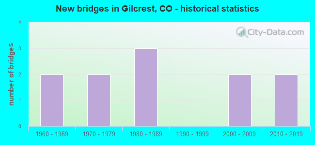
- New bridges - historical statistics
- 21960-1969
- 21970-1979
- 31980-1989
- 22000-2009
- 22010-2019


- Bridge Condition - Deck
- 9.1%Very good
- 27.3%Good
- 45.5%Satisfactory
- 18.2%Fair

- Bridge Condition - Superstructure
- 27.3%Good
- 45.5%Satisfactory
- 27.3%Fair

- Bridge Condition - Substructure
- 45.5%Good
- 36.4%Satisfactory
- 18.2%Fair

- Bridge Condition - Channel
- 72.7%Very good
- 9.1%Good
- 18.2%Satisfactory
Find on map >> Show street view
Structure Number: WEL029.0-042.0A, Location: 0.5 Mi N of Co Rd 42 (Lat: 40.295306, Lng: -104.791861), Route carried "on" structure: County highway , Year Built: 2005, Status: Open, Structure Length: 0.82m (2.69ft), Average Daily Traffic: 213 (year 2021), Truck Traffic: 72%, Average Future Daily Traffic: 302 (year 2041), Design Load: HS 20, Features Intersected: Western Mutual Ditch, Facility Carried by Structure: County Road 29
Minimum Vertical Clearance: 30+ m (98+ ft), Kilometerpoint: 1.597, Lanes on structure: 2, Owner: County Highway Agency, Approaching Roadway Width: 7.6m (24.9ft), Skew: 2 degrees, Material/Design: Steel, Design/Construction: Stringer/Multi-beam, Number Of Spans In Main Unit: 1, Length of Maximum Span: 7.4m (24.3ft), Curb-To-Curb Width: 10.7m (35.1ft), Out-to-Out Width: 11.0m (36.1ft)
Condition: Deck: Satisfactory, Superstructure: Satisfactory, Substructure: Satisfactory, Channel: Satisfactory, Operating Rating: 64.0 metric tons, Method Used To Determine Operating Rating: Load Factor (LF), Inventory Rating: 38.4 metric tons, Method Used To Determine Inventory Rating: Load Factor (LF), Structural Evaluation: Equal to present minimum criteria, Deck Geometry: Better than present minimum criteria, Waterway Adequacy: Equal to present minimum criteria, Approach Roadway Alignment: Equal to present desirable criteria, Designated Inspection Frequency: Every 24 months, Inspection Date: March 2022, Deck Structure Type: Corrugated Steel, Wearing Surface/Protective System: Wearing Surface: Gravel
Find on map >> Show street view
Structure Number: WEL031.0-036.0A, Location: 0.3 Mi n of Co Rd 36 (Lat: 40.252333, Lng: -104.772917), Route carried "on" structure: County highway , Year Built: 1980, Status: Open, Structure Length: 0.93m (3.05ft), Average Daily Traffic: 107 (year 2020), Truck Traffic: 41%, Average Future Daily Traffic: 152 (year 2040), Design Load: HS 20, Features Intersected: Platte Valley Canal, Facility Carried by Structure: County Road 31
Minimum Vertical Clearance: 30+ m (98+ ft), Kilometerpoint: 8.621, Lanes on structure: 2, Owner: County Highway Agency, Approaching Roadway Width: 7.3m (24.0ft), Material/Design: Steel, Design/Construction: Stringer/Multi-beam, Number Of Spans In Main Unit: 1, Length of Maximum Span: 8.3m (27.2ft), Curb-To-Curb Width: 9.8m (32.2ft), Out-to-Out Width: 9.8m (32.2ft)
Condition: Deck: Satisfactory, Superstructure: Satisfactory, Substructure: Satisfactory, Channel: Satisfactory, Operating Rating: 54.3 metric tons, Method Used To Determine Operating Rating: Load Factor (LF), Inventory Rating: 32.6 metric tons, Method Used To Determine Inventory Rating: Load Factor (LF), Structural Evaluation: Equal to present minimum criteria, Deck Geometry: Better than present minimum criteria, Waterway Adequacy: Equal to present desirable criteria, Approach Roadway Alignment: Equal to present desirable criteria, Designated Inspection Frequency: Every 24 months, Inspection Date: March 2022, Deck Structure Type: Corrugated Steel, Wearing Surface/Protective System: Wearing Surface: Gravel
Find on map >> Show street view
Structure Number: WEL031.0-036.0B, Location: 0.5 Mi N of Co Rd 36 (Lat: 40.253722, Lng: -104.772917), Route carried "on" structure: County highway , Year Built: 1973, Status: Open, Structure Length: 0.93m (3.05ft), Average Daily Traffic: 107 (year 2020), Truck Traffic: 41%, Average Future Daily Traffic: 152 (year 2040), Features Intersected: Evans Ditch No. 2, Facility Carried by Structure: County Road 31
Minimum Vertical Clearance: 30+ m (98+ ft), Kilometerpoint: 8.838, Lanes on structure: 2, Owner: County Highway Agency, Approaching Roadway Width: 7.3m (24.0ft), Material/Design: Prestressed concrete, Design/Construction: Tee Beam, Number Of Spans In Main Unit: 1, Length of Maximum Span: 8.9m (29.2ft), Curb-To-Curb Width: 9.0m (29.5ft), Out-to-Out Width: 9.1m (29.9ft)
Condition: Deck: Satisfactory, Superstructure: Satisfactory, Substructure: Fair, Channel: Very good, Operating Rating: 36.3 metric tons, Method Used To Determine Operating Rating: Field evaluation and documented engineering judgment, Inventory Rating: 32.7 metric tons, Method Used To Determine Inventory Rating: Field evaluation and documented engineering judgment, Structural Evaluation: Somewhat better than minimum adequacy, Deck Geometry: Equal to present minimum criteria, Waterway Adequacy: Equal to present desirable criteria, Approach Roadway Alignment: Equal to present desirable criteria, Designated Inspection Frequency: Every 24 months, Inspection Date: March 2022, Deck Structure Type: Other, Wearing Surface/Protective System: Wearing Surface: Gravel
Find on map >> Show street view
Structure Number: WEL033.0-038.0A, Location: 0.4 Mi N of Co Rd 38 (Lat: 40.266750, Lng: -104.753806), Route carried "on" structure: County highway , Year Built: 1968, Status: Open, Structure Length: 1.04m (3.41ft), Average Daily Traffic: 328 (year 2021), Truck Traffic: 47%, Average Future Daily Traffic: 466 (year 2041), Design Load: HS 20, Features Intersected: Platte Valley Canal, Facility Carried by Structure: County Road 33
Minimum Vertical Clearance: 30+ m (98+ ft), Kilometerpoint: 5.459, Lanes on structure: 2, Owner: County Highway Agency, Approaching Roadway Width: 7.3m (24.0ft), Skew: 3 degrees, Material/Design: Prestressed concrete, Design/Construction: Tee Beam, Number Of Spans In Main Unit: 1, Length of Maximum Span: 9.9m (32.5ft), Curb-To-Curb Width: 8.3m (27.2ft), Out-to-Out Width: 8.5m (27.9ft)
Condition: Deck: Fair, Superstructure: Fair, Substructure: Fair, Channel: Very good, Operating Rating: 32.7 metric tons, Method Used To Determine Operating Rating: Field evaluation and documented engineering judgment, Inventory Rating: 32.7 metric tons, Method Used To Determine Inventory Rating: Field evaluation and documented engineering judgment, Structural Evaluation: Somewhat better than minimum adequacy, Deck Geometry: Somewhat better than minimum adequacy, Waterway Adequacy: Equal to present desirable criteria, Approach Roadway Alignment: Equal to present desirable criteria, Designated Inspection Frequency: Every 24 months, Inspection Date: March 2022, Deck Structure Type: Other, Wearing Surface/Protective System: Wearing Surface: Gravel
Find on map >> Show street view
Structure Number: WEL033.0-038.0B, Location: 0.5 Mi N of Co Rd 38 (Lat: 40.268806, Lng: -104.753806), Route carried "on" structure: County highway , Year Built: 1978, Status: Open, Structure Length: 0.94m (3.08ft), Average Daily Traffic: 328 (year 2021), Truck Traffic: 47%, Average Future Daily Traffic: 466 (year 2041), Design Load: HS 20, Features Intersected: Evans Ditch No. 2, Facility Carried by Structure: County Road 33
Minimum Vertical Clearance: 30+ m (98+ ft), Kilometerpoint: 5.675, Lanes on structure: 2, Owner: County Highway Agency, Approaching Roadway Width: 7.3m (24.0ft), Skew: 2 degrees, Material/Design: Steel, Design/Construction: Stringer/Multi-beam, Number Of Spans In Main Unit: 1, Length of Maximum Span: 8.4m (27.6ft), Curb-To-Curb Width: 9.2m (30.2ft), Out-to-Out Width: 9.7m (31.8ft)
Condition: Deck: Good, Superstructure: Satisfactory, Substructure: Good, Channel: Very good, Operating Rating: 41.5 metric tons, Method Used To Determine Operating Rating: Load and Resistance Factor Rating (LRFR) rating reported by rating factor(RF) method using HL-93 loadings, Inventory Rating: 31.8 metric tons, Method Used To Determine Inventory Rating: Load and Resistance Factor Rating (LRFR) rating reported by rating factor(RF) method using HL-93 loadings, Structural Evaluation: Equal to present minimum criteria, Deck Geometry: Equal to present minimum criteria, Waterway Adequacy: Equal to present desirable criteria, Approach Roadway Alignment: Equal to present desirable criteria, Designated Inspection Frequency: Every 24 months, Inspection Date: March 2022, Deck Structure Type: Corrugated Steel, Wearing Surface/Protective System: Wearing Surface: Gravel
Find on map >> Show street view
Structure Number: WEL035.0-038.0A, Location: 0.5 Mi N of Co Rd 38 (Lat: 40.267833, Lng: -104.734694), Route carried "on" structure: County highway , Year Built: 1966, Year Reconstructed: 2020, Status: Open, Structure Length: 0.93m (3.05ft), Average Daily Traffic: 376 (year 2021), Truck Traffic: 55%, Average Future Daily Traffic: 534 (year 2041), Design Load: HS 20, Features Intersected: Platte Valley Canal, Facility Carried by Structure: County Road 35
Minimum Vertical Clearance: 30+ m (98+ ft), Kilometerpoint: 5.571, Lanes on structure: 2, Owner: County Highway Agency, Approaching Roadway Width: 7.0m (23.0ft), Material/Design: Steel, Design/Construction: Stringer/Multi-beam, Number Of Spans In Main Unit: 1, Length of Maximum Span: 8.3m (27.2ft), Curb-To-Curb Width: 8.6m (28.2ft), Out-to-Out Width: 8.8m (28.9ft)
Condition: Deck: Good, Superstructure: Good, Substructure: Good, Channel: Good, Operating Rating: 40.8 metric tons, Method Used To Determine Operating Rating: Load and Resistance Factor Rating (LRFR) rating reported by rating factor(RF) method using HL-93 loadings, Inventory Rating: 31.4 metric tons, Method Used To Determine Inventory Rating: Load and Resistance Factor Rating (LRFR) rating reported by rating factor(RF) method using HL-93 loadings, Structural Evaluation: Better than present minimum criteria, Deck Geometry: Equal to present minimum criteria, Waterway Adequacy: Equal to present desirable criteria, Approach Roadway Alignment: Equal to present desirable criteria, Designated Inspection Frequency: Every 24 months, Inspection Date: March 2022, Deck Structure Type: Corrugated Steel, Wearing Surface/Protective System: Wearing Surface: Gravel
Find on map >> Show street view
Structure Number: WEL035.0-038.0B, Location: .6 Mi N of CR 38 (Lat: 40.269194, Lng: -104.734722), Route carried "on" structure: County highway , Year Built: 2010, Status: Open, Structure Length: 1.19m (3.90ft), Average Daily Traffic: 376 (year 2021), Truck Traffic: 55%, Average Future Daily Traffic: 534 (year 2041), Design Load: HS 20, Features Intersected: Evans Ditch No. 2, Facility Carried by Structure: County Road 35
Minimum Vertical Clearance: 30+ m (98+ ft), Kilometerpoint: 5.702, Lanes on structure: 2, Owner: County Highway Agency, Approaching Roadway Width: 7.3m (24.0ft), Skew: 2 degrees, Material/Design: Steel, Design/Construction: Stringer/Multi-beam, Number Of Spans In Main Unit: 1, Length of Maximum Span: 11.2m (36.7ft), Curb-To-Curb Width: 8.9m (29.2ft), Out-to-Out Width: 9.2m (30.2ft)
Condition: Deck: Satisfactory, Superstructure: Good, Substructure: Good, Channel: Very good, Operating Rating: 53.3 metric tons, Method Used To Determine Operating Rating: Load Factor (LF), Inventory Rating: 31.8 metric tons, Method Used To Determine Inventory Rating: Load Factor (LF), Structural Evaluation: Better than present minimum criteria, Deck Geometry: Equal to present minimum criteria, Waterway Adequacy: Equal to present desirable criteria, Approach Roadway Alignment: Equal to present desirable criteria, Designated Inspection Frequency: Every 24 months, Inspection Date: May 2020, Deck Structure Type: Corrugated Steel, Wearing Surface/Protective System: Wearing Surface: Gravel
Find on map >> Show street view
Structure Number: WEL036.0-029.0B, Location: 0.8 Mi E of Co Rd 29 (Lat: 40.246750, Lng: -104.776083), Route carried "on" structure: County highway , Year Built: 1981, Status: Open, Structure Length: 0.80m (2.62ft), Average Daily Traffic: 147 (year 2020), Truck Traffic: 58%, Average Future Daily Traffic: 209 (year 2040), Design Load: HS 20, Features Intersected: Platte Valley Canal, Facility Carried by Structure: County Road 36
Minimum Vertical Clearance: 30+ m (98+ ft), Kilometerpoint: 6.161, Lanes on structure: 2, Owner: County Highway Agency, Approaching Roadway Width: 7.3m (24.0ft), Material/Design: Steel, Design/Construction: Stringer/Multi-beam, Number Of Spans In Main Unit: 1, Length of Maximum Span: 7.1m (23.3ft), Curb-To-Curb Width: 9.6m (31.5ft), Out-to-Out Width: 9.7m (31.8ft)
Condition: Deck: Satisfactory, Superstructure: Fair, Substructure: Satisfactory, Channel: Very good, Operating Rating: 71.5 metric tons, Method Used To Determine Operating Rating: Load Factor (LF), Inventory Rating: 42.8 metric tons, Method Used To Determine Inventory Rating: Load Factor (LF), Structural Evaluation: Somewhat better than minimum adequacy, Deck Geometry: Equal to present minimum criteria, Waterway Adequacy: Equal to present desirable criteria, Approach Roadway Alignment: Equal to present desirable criteria, Designated Inspection Frequency: Every 24 months, Inspection Date: March 2022, Deck Structure Type: Corrugated Steel, Wearing Surface/Protective System: Wearing Surface: Gravel
Find on map >> Show street view
Structure Number: WEL036.0-029.1A, Location: 0.6 Mi E of Co Rd 29 (Lat: 40.246722, Lng: -104.779083), Route carried "on" structure: County highway , Year Built: 1985, Year Reconstructed: 2020, Status: Open, Structure Length: 0.92m (3.02ft), Average Daily Traffic: 147 (year 2020), Truck Traffic: 58%, Average Future Daily Traffic: 209 (year 2040), Design Load: HL 93, Features Intersected: Evans Ditch No. 2, Facility Carried by Structure: County Road 36
Minimum Vertical Clearance: 30+ m (98+ ft), Kilometerpoint: 5.906, Lanes on structure: 2, Owner: County Highway Agency, Approaching Roadway Width: 6.7m (22.0ft), Material/Design: Steel, Design/Construction: Stringer/Multi-beam, Number Of Spans In Main Unit: 1, Length of Maximum Span: 8.6m (28.2ft), Curb-To-Curb Width: 9.3m (30.5ft), Out-to-Out Width: 9.7m (31.8ft)
Condition: Deck: Very good, Superstructure: Fair, Substructure: Satisfactory, Channel: Very good, Operating Rating: 36.6 metric tons, Method Used To Determine Operating Rating: Load and Resistance Factor Rating (LRFR) rating reported by rating factor(RF) method using HL-93 loadings, Inventory Rating: 28.2 metric tons, Method Used To Determine Inventory Rating: Load and Resistance Factor Rating (LRFR) rating reported by rating factor(RF) method using HL-93 loadings, Structural Evaluation: Somewhat better than minimum adequacy, Deck Geometry: Equal to present minimum criteria, Waterway Adequacy: Equal to present desirable criteria, Approach Roadway Alignment: Equal to present desirable criteria, Designated Inspection Frequency: Every 24 months, Inspection Date: March 2022, Deck Structure Type: Corrugated Steel, Wearing Surface/Protective System: Wearing Surface: Bituminous
Find on map >> Show street view
Structure Number: WEL038.0_031.0A, Location: 0.7 Mi E of Co Rd 31 (Lat: 40.261111, Lng: -104.760833), Route carried "on" structure: County highway , Year Built: 2015, Status: Open, Structure Length: 0.91m (2.99ft), Average Daily Traffic: 175 (year 2020), Truck Traffic: 44%, Average Future Daily Traffic: 249 (year 2040), Design Load: HL 93, Features Intersected: Evan Ditch No. 2, Facility Carried by Structure: County Road 38
Minimum Vertical Clearance: 30+ m (98+ ft), Kilometerpoint: 2.623, Lanes on structure: 2, Owner: County Highway Agency, Approaching Roadway Width: 7.6m (24.9ft), Material/Design: Steel, Design/Construction: Stringer/Multi-beam, Number Of Spans In Main Unit: 1, Length of Maximum Span: 8.6m (28.2ft), Curb-To-Curb Width: 9.4m (30.8ft), Out-to-Out Width: 9.7m (31.8ft)
Condition: Deck: Good, Superstructure: Good, Substructure: Good, Channel: Very good, Operating Rating: 42.1 metric tons, Method Used To Determine Operating Rating: Load and Resistance Factor Rating (LRFR) rating reported by rating factor(RF) method using HL-93 loadings, Inventory Rating: 32.4 metric tons, Method Used To Determine Inventory Rating: Load and Resistance Factor Rating (LRFR) rating reported by rating factor(RF) method using HL-93 loadings, Structural Evaluation: Better than present minimum criteria, Deck Geometry: Equal to present minimum criteria, Waterway Adequacy: Equal to present desirable criteria, Approach Roadway Alignment: Equal to present desirable criteria, Designated Inspection Frequency: Every 24 months, Inspection Date: March 2022, Deck Structure Type: Corrugated Steel, Wearing Surface/Protective System: Wearing Surface: Gravel
Find on map >> Show street view
Structure Number: WEL038.0_031.0B, Location: 0.8 Mi E of Co Rd 31 (Lat: 40.261056, Lng: -104.755944), Route carried "on" structure: County highway , Year Built: 2005, Status: Open, Structure Length: 0.92m (3.02ft), Average Daily Traffic: 175 (year 2020), Truck Traffic: 44%, Average Future Daily Traffic: 249 (year 2040), Design Load: HS 20, Features Intersected: Platte Valley Canal, Facility Carried by Structure: County Road 38
Minimum Vertical Clearance: 30+ m (98+ ft), Kilometerpoint: 3.046, Lanes on structure: 2, Owner: County Highway Agency, Approaching Roadway Width: 7.3m (24.0ft), Material/Design: Steel, Design/Construction: Stringer/Multi-beam, Number Of Spans In Main Unit: 1, Length of Maximum Span: 8.4m (27.6ft), Curb-To-Curb Width: 8.9m (29.2ft), Out-to-Out Width: 9.1m (29.9ft)
Condition: Deck: Fair, Superstructure: Satisfactory, Substructure: Good, Channel: Very good, Operating Rating: 63.3 metric tons, Method Used To Determine Operating Rating: Load Factor (LF), Inventory Rating: 37.9 metric tons, Method Used To Determine Inventory Rating: Load Factor (LF), Structural Evaluation: Equal to present minimum criteria, Deck Geometry: Equal to present minimum criteria, Waterway Adequacy: Equal to present desirable criteria, Approach Roadway Alignment: Equal to present desirable criteria, Designated Inspection Frequency: Every 24 months, Inspection Date: March 2022, Deck Structure Type: Corrugated Steel, Wearing Surface/Protective System: Wearing Surface: Gravel