Bridge Statistics for Glendale, Wisconsin (WI)
Condition, Traffic, Stress, Structural Evaluation, Project Costs
- National Bridge Inventory (NBI) Statistics
- 44Number of bridges
- 466ft / 142mTotal length
- $12,667,000Total costs
- 1,255,762Total average daily traffic
- 14,011Total average daily truck traffic
- National Bridge Inventory (NBI) Registered Bridges for Glendale
- No street view available for this location
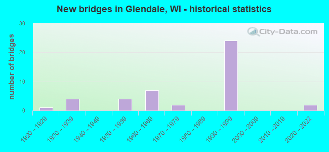
- New bridges - historical statistics
- 11920-1929
- 41930-1939
- 41950-1959
- 71960-1969
- 21970-1979
- 241990-1999
- 22020-2022

- Reconstructed bridges - Historical Statistics
- 11960-1969
- 11970-1979
- 01980-1989
- 31990-1999
- 12000-2009


- Bridge Condition - Deck
- 4.5%Excellent
- 40.9%Good
- 31.8%Satisfactory
- 13.6%Fair
- 9.1%Poor

- Bridge Condition - Superstructure
- 4.5%Excellent
- 31.8%Very good
- 31.8%Good
- 9.1%Satisfactory
- 9.1%Fair
- 13.6%Poor

- Bridge Condition - Substructure
- 4.5%Excellent
- 45.5%Good
- 22.7%Satisfactory
- 18.2%Fair
- 9.1%Poor

- Bridge Condition - Channel
- 9.1%Excellent
- 54.5%Very good
- 18.2%Good
- 9.1%Fair
- 9.1%Poor
Find on map >> Show street view
Structure Number: B400066, Location: 1.1 MI N JCT STH 190 (Lat: 43.102831, Lng: -87.917933), Route carried "on" structure: Interstate 43, Year Built: 1959, Year Reconstructed: 1983, Status: Open, Structure Length: 17.55m (57.58ft), Average Daily Traffic: 107,000 (year 2019), Truck Traffic: 1%, Average Future Daily Traffic: 144,650 (year 2040), Design Load: HS 20, Features Intersected: LRD W HAMPTON AVE
Minimum Vertical Clearance: 30+ m (98+ ft), Kilometerpoint: 0.000, Lanes on structure: 6, Lanes under structure: 5, Base Highway Network: Yes, Owner: State Highway Agency, Approaching Roadway Width: 24.4m (80.1ft), Skew: 30 degrees, Material/Design: Prestressed concrete, Design/Construction: Stringer/Multi-beam, Number Of Spans In Main Unit: 9, Length of Maximum Span: 22.1m (72.5ft), Curb-To-Curb Width: 29.3m (96.1ft), Out-to-Out Width: 31.4m (103.0ft)
Condition: Deck: Fair, Superstructure: Poor, Substructure: Poor, Channel: Very good, Operating Rating: 31.0 metric tons, Method Used To Determine Operating Rating: Load Factor (LF), Inventory Rating: 17.8 metric tons, Method Used To Determine Inventory Rating: Load Factor (LF), Structural Evaluation: Meets minimum limits, Deck Geometry: Better than present minimum criteria, Underclear: Meets minimum limits, Waterway Adequacy: Superior to present desirable criteria, Approach Roadway Alignment: Equal to present desirable criteria, Length Of Structure Improvement: 17.98m (58.99ft), Designated Inspection Frequency: Every 12 months, Inspection Date: May 2021, Bridge Improvement Cost: $2,233,000, Roadway Improvement Cost: $223,000, Total Project Cost: $3,350,000 ( Estimate for 2021), Deck Structure Type: Concrete Cast-file-Place, Wearing Surface/Protective System: Wearing Surface: Bituminous, Deck Protection: Epoxy Coated Reinforcing
Find on map >> Show street view
Structure Number: B400067, Location: 0.1M W JCT IH 43 (Lat: 43.103831, Lng: -87.918703), Route carried "on" structure: Ramp Interstate 43, Year Built: 1962, Status: Open, Structure Length: 11.41m (37.43ft), Average Daily Traffic: 10,600 (year 2019), Truck Traffic: 1%, Average Future Daily Traffic: 72,325 (year 2040), Design Load: HS 20, Features Intersected: MILWAUKEE RIVER, Facility Carried by Structure: IH RAMP HAMPTON AV
Minimum Vertical Clearance: 30+ m (98+ ft), Kilometerpoint: 0.000, Lanes on structure: 2, Owner: State Highway Agency, Approaching Roadway Width: 7.3m (24.0ft), Material/Design: Prestressed concrete, Design/Construction: Stringer/Multi-beam, Number Of Spans In Main Unit: 6, Length of Maximum Span: 22.1m (72.5ft), Curb-To-Curb Width: 7.8m (25.6ft), Out-to-Out Width: 8.7m (28.5ft)
Condition: Deck: Poor, Superstructure: Fair, Substructure: Fair, Channel: Excellent, Operating Rating: 42.5 metric tons, Method Used To Determine Operating Rating: Load Factor (LF), Inventory Rating: 27.5 metric tons, Method Used To Determine Inventory Rating: Load Factor (LF), Structural Evaluation: Somewhat better than minimum adequacy, Deck Geometry: High priority of replacement, Waterway Adequacy: Superior to present desirable criteria, Approach Roadway Alignment: Equal to present desirable criteria, Length Of Structure Improvement: 11.86m (38.91ft), Designated Inspection Frequency: Every 12 months, Inspection Date: May 2021, Bridge Improvement Cost: $1,471,000, Roadway Improvement Cost: $147,000, Total Project Cost: $2,207,000 ( Estimate for 2021), Deck Structure Type: Concrete Cast-file-Place, Wearing Surface/Protective System: Wearing Surface: Bituminous, Deck Protection: Epoxy Coated Reinforcing
Find on map >> Show street view
Structure Number: B400073, Location: 0.9 MI N JCT STH 190 (Lat: 43.099933, Lng: -87.918078), Route carried "on" structure: Interstate 43, Year Built: 1960, Year Reconstructed: 1974, Status: Open, Structure Length: 3.97m (13.02ft), Average Daily Traffic: 126,000 (year 2019), Truck Traffic: 1%, Average Future Daily Traffic: 144,650 (year 2040), Design Load: HS 20, Features Intersected: LRD GLENDALE AVE
Minimum Vertical Clearance: 30+ m (98+ ft), Kilometerpoint: 0.000, Lanes on structure: 6, Lanes under structure: 2, Base Highway Network: Yes, Owner: State Highway Agency, Approaching Roadway Width: 30.5m (100.1ft), Skew: 30 degrees, Material/Design: Steel, Design/Construction: Stringer/Multi-beam, Number Of Spans In Main Unit: 3, Length of Maximum Span: 21.0m (68.9ft), Curb-To-Curb Width: 30.5m (100.1ft), Out-to-Out Width: 32.9m (107.9ft)
Condition: Deck: Fair, Superstructure: Fair, Substructure: Poor, Operating Rating: 57.0 metric tons, Method Used To Determine Operating Rating: Load Factor (LF), Inventory Rating: 34.0 metric tons, Method Used To Determine Inventory Rating: Load Factor (LF), Structural Evaluation: Meets minimum limits, Deck Geometry: Superior to present desirable criteria, Underclear: Meets minimum limits, Approach Roadway Alignment: Equal to present desirable criteria, Length Of Structure Improvement: 4.42m (14.50ft), Designated Inspection Frequency: Every 12 months, Other Special Inspection Frequency: Every 72 months, Inspection Date: March 2021, Other Special Inspection Date: September 2017, Bridge Improvement Cost: $548,000, Roadway Improvement Cost: $54,000, Total Project Cost: $822,000 ( Estimate for 2021), Deck Structure Type: Concrete Cast-file-Place, Wearing Surface/Protective System: Wearing Surface: Monolithic Concrete, Deck Protection: Epoxy Coated Reinforcing
Find on map >> Show street view
Structure Number: B400372, Location: 0.5M E JCT STH 57 (Lat: 43.147769, Lng: -87.930436), Route carried "on" structure: County highway , Year Built: 1967, Year Reconstructed: 2001, Status: Open, Structure Length: 5.42m (17.78ft), Average Daily Traffic: 15,150 (year 2019), Truck Traffic: 12%, Average Future Daily Traffic: 32,884 (year 2039), Design Load: HS 20, Features Intersected: MILWAUKEE RIVER, Facility Carried by Structure: CTH PP W GOOD HOP
Minimum Vertical Clearance: 30+ m (98+ ft), Kilometerpoint: 0.000, Lanes on structure: 3, Base Highway Network: Yes, Owner: County Highway Agency, Approaching Roadway Width: 12.5m (41.0ft), Skew: 1 degrees, Material/Design: Steel continuous, Design/Construction: Stringer/Multi-beam, Number Of Spans In Main Unit: 3, Length of Maximum Span: 21.6m (70.9ft), Curb or Sidewalk Widths: Left: 0.0m, Right: 2.0m (6.6ft), Curb-To-Curb Width: 12.5m (41.0ft), Out-to-Out Width: 15.1m (49.5ft)
Condition: Deck: Good, Superstructure: Good, Substructure: Good, Channel: Very good, Operating Rating: 42.5 metric tons, Method Used To Determine Operating Rating: Load Factor (LF), Inventory Rating: 25.9 metric tons, Method Used To Determine Inventory Rating: Load Factor (LF), Structural Evaluation: Equal to present minimum criteria, Deck Geometry: Meets minimum limits, Waterway Adequacy: Equal to present desirable criteria, Approach Roadway Alignment: Equal to present desirable criteria, Designated Inspection Frequency: Every 24 months, Inspection Date: June 2020, Deck Structure Type: Concrete Cast-file-Place, Wearing Surface/Protective System: Wearing Surface: Monolithic Concrete, Deck Protection: Epoxy Coated Reinforcing
Find on map >> Show street view
Structure Number: B400373, Location: 0.7M W JCT IH 43 (Lat: 43.148106, Lng: -87.929917), Route carried "on" structure: County highway , Year Built: 1967, Year Reconstructed: 2001, Status: Open, Structure Length: 5.45m (17.88ft), Average Daily Traffic: 15,150 (year 2019), Truck Traffic: 12%, Average Future Daily Traffic: 32,884 (year 2039), Design Load: HS 20, Features Intersected: MILWAUKEE RIVER, Facility Carried by Structure: CTH PP W GOOD HOP
Minimum Vertical Clearance: 30+ m (98+ ft), Kilometerpoint: 0.000, Lanes on structure: 3, Base Highway Network: Yes, Owner: County Highway Agency, Approaching Roadway Width: 12.5m (41.0ft), Skew: 1 degrees, Material/Design: Steel continuous, Design/Construction: Stringer/Multi-beam, Number Of Spans In Main Unit: 3, Length of Maximum Span: 21.6m (70.9ft), Curb or Sidewalk Widths: Left: 2.0m (6.6ft), Right: 0.0m, Curb-To-Curb Width: 12.5m (41.0ft), Out-to-Out Width: 15.1m (49.5ft)
Condition: Deck: Good, Superstructure: Good, Substructure: Satisfactory, Channel: Good, Operating Rating: 44.1 metric tons, Method Used To Determine Operating Rating: Load Factor (LF), Inventory Rating: 25.9 metric tons, Method Used To Determine Inventory Rating: Load Factor (LF), Structural Evaluation: Equal to present minimum criteria, Deck Geometry: Meets minimum limits, Waterway Adequacy: Equal to present desirable criteria, Approach Roadway Alignment: Equal to present desirable criteria, Designated Inspection Frequency: Every 24 months, Inspection Date: June 2020, Deck Structure Type: Concrete Cast-file-Place, Wearing Surface/Protective System: Wearing Surface: Monolithic Concrete, Deck Protection: Epoxy Coated Reinforcing
Find on map >> Show street view
Structure Number: B40057, Location: 0.2M W JCT STH 32 (Lat: 43.136672, Lng: -87.906172), Route carried "on" structure: City street , Year Built: 1990, Status: Open, Structure Length: 6.93m (22.74ft), Average Daily Traffic: 2,500 (year 2019), Truck Traffic: 5%, Average Future Daily Traffic: 4,409 (year 2039), Design Load: HS 20, Features Intersected: CNW RR, Facility Carried by Structure: LRD N SANTA MONICA
Minimum Vertical Clearance: 30+ m (98+ ft), Kilometerpoint: 0.000, Lanes on structure: 2, Owner: City or Municipal Highway Agency, Approaching Roadway Width: 10.1m (33.1ft), Skew: 5 degrees, Material/Design: Prestressed concrete continuous, Design/Construction: Stringer/Multi-beam, Number Of Spans In Main Unit: 3, Length of Maximum Span: 21.9m (71.9ft), Curb or Sidewalk Widths: Left: 2.4m (7.9ft), Right: 0.0m, Curb-To-Curb Width: 9.1m (29.9ft), Out-to-Out Width: 12.3m (40.4ft)
Condition: Deck: Satisfactory, Superstructure: Very good, Substructure: Good, Operating Rating: 62.1 metric tons, Method Used To Determine Operating Rating: Load Factor (LF), Inventory Rating: 27.5 metric tons, Method Used To Determine Inventory Rating: Load Factor (LF), Structural Evaluation: Equal to present minimum criteria, Deck Geometry: Meets minimum limits, Underclear: Better than present minimum criteria, Approach Roadway Alignment: Equal to present desirable criteria, Designated Inspection Frequency: Every 24 months, Inspection Date: July 2020, Deck Structure Type: Concrete Cast-file-Place, Wearing Surface/Protective System: Wearing Surface: Monolithic Concrete, Deck Protection: Epoxy Coated Reinforcing
Find on map >> Show street view
Structure Number: B400577, Location: 3.0M N JCT STH 190 TO E (Lat: 43.129414, Lng: -87.913186), Route carried "on" structure: Interstate 43, Year Built: 1992, Status: Open, Structure Length: 3.12m (10.24ft), Average Daily Traffic: 46,350 (year 2019), Truck Traffic: 1%, Average Future Daily Traffic: 72,325 (year 2040), Design Load: HS 20, Features Intersected: LRD BENDER RD
Minimum Vertical Clearance: 30+ m (98+ ft), Kilometerpoint: 0.000, Lanes on structure: 2, Lanes under structure: 4, Base Highway Network: Yes, Owner: State Highway Agency, Approaching Roadway Width: 14.3m (46.9ft), Material/Design: Steel, Design/Construction: Stringer/Multi-beam, Number Of Spans In Main Unit: 1, Length of Maximum Span: 29.9m (98.1ft), Curb-To-Curb Width: 17.1m (56.1ft), Out-to-Out Width: 17.8m (58.4ft)
Condition: Deck: Satisfactory, Superstructure: Satisfactory, Substructure: Satisfactory, Operating Rating: 63.7 metric tons, Method Used To Determine Operating Rating: Load Factor (LF), Inventory Rating: 37.3 metric tons, Method Used To Determine Inventory Rating: Load Factor (LF), Structural Evaluation: Equal to present minimum criteria, Deck Geometry: Superior to present desirable criteria, Underclear: Somewhat better than minimum adequacy, Approach Roadway Alignment: Equal to present desirable criteria, Designated Inspection Frequency: Every 24 months, Inspection Date: March 2021, Deck Structure Type: Concrete Cast-file-Place, Wearing Surface/Protective System: Wearing Surface: Bituminous, Membrane: Other, Deck Protection: Epoxy Coated Reinforcing
Find on map >> Show street view
Structure Number: B400578, Location: 3.4M S JCT STH 100 TO S (Lat: 43.129742, Lng: -87.913614), Route carried "on" structure: Interstate 43, Year Built: 1992, Status: Open, Structure Length: 3.11m (10.20ft), Average Daily Traffic: 46,350 (year 2019), Truck Traffic: 1%, Average Future Daily Traffic: 52,800 (year 2040), Design Load: HS 20, Features Intersected: LRD BENDER RD
Minimum Vertical Clearance: 30+ m (98+ ft), Kilometerpoint: 0.000, Lanes on structure: 2, Lanes under structure: 4, Base Highway Network: Yes, Owner: State Highway Agency, Approaching Roadway Width: 17.1m (56.1ft), Material/Design: Steel, Design/Construction: Stringer/Multi-beam, Number Of Spans In Main Unit: 1, Length of Maximum Span: 29.9m (98.1ft), Curb-To-Curb Width: 17.1m (56.1ft), Out-to-Out Width: 17.8m (58.4ft)
Condition: Deck: Satisfactory, Superstructure: Satisfactory, Substructure: Satisfactory, Operating Rating: 63.7 metric tons, Method Used To Determine Operating Rating: Load Factor (LF), Inventory Rating: 37.3 metric tons, Method Used To Determine Inventory Rating: Load Factor (LF), Structural Evaluation: Equal to present minimum criteria, Deck Geometry: Superior to present desirable criteria, Underclear: Meets minimum limits, Approach Roadway Alignment: Equal to present desirable criteria, Designated Inspection Frequency: Every 24 months, Inspection Date: March 2021, Deck Structure Type: Concrete Cast-file-Place, Wearing Surface/Protective System: Wearing Surface: Bituminous, Membrane: Other, Deck Protection: Epoxy Coated Reinforcing
Find on map >> Show street view
Structure Number: B400579, Location: 0.6M E JCT STH 57 (Lat: 43.118536, Lng: -87.921106), Route carried "on" structure: County highway , Year Built: 1991, Status: Open, Structure Length: 9.11m (29.89ft), Average Daily Traffic: 16,100 (year 2018), Average Future Daily Traffic: 17,700 (year 2038), Design Load: HS 20, Features Intersected: MILWAUKEE RIVER, Facility Carried by Structure: CTH E SILVER SPRI
Minimum Vertical Clearance: 30+ m (98+ ft), Kilometerpoint: 0.000, Lanes on structure: 3, Base Highway Network: Yes, Owner: State Highway Agency, Approaching Roadway Width: 11.6m (38.1ft), Skew: 23 degrees, Material/Design: Prestressed concrete continuous, Design/Construction: Stringer/Multi-beam, Number Of Spans In Main Unit: 3, Length of Maximum Span: 30.1m (98.8ft), Curb or Sidewalk Widths: Left: 0.0m, Right: 2.0m (6.6ft), Curb-To-Curb Width: 12.2m (40.0ft), Out-to-Out Width: 16.5m (54.1ft)
Condition: Deck: Good, Superstructure: Very good, Substructure: Good, Channel: Very good, Operating Rating: 70.2 metric tons, Method Used To Determine Operating Rating: Load Factor (LF), Inventory Rating: 37.3 metric tons, Method Used To Determine Inventory Rating: Load Factor (LF), Structural Evaluation: Better than present minimum criteria, Deck Geometry: Meets minimum limits, Waterway Adequacy: Equal to present desirable criteria, Approach Roadway Alignment: Equal to present desirable criteria, Designated Inspection Frequency: Every 48 months, Inspection Date: March 2021, Deck Structure Type: Concrete Cast-file-Place, Wearing Surface/Protective System: Wearing Surface: Monolithic Concrete, Deck Protection: Epoxy Coated Reinforcing
Find on map >> Show street view
Structure Number: B40058, Location: 0.1M W JCT IH 43 (Lat: 43.118786, Lng: -87.919747), Route carried "on" structure: County highway , Year Built: 1991, Status: Open, Structure Length: 9.11m (29.89ft), Average Daily Traffic: 16,100 (year 2018), Average Future Daily Traffic: 17,700 (year 2038), Design Load: HS 20, Features Intersected: MILWAUKEE RIVER, Facility Carried by Structure: CTH E SILVER SPRI
Minimum Vertical Clearance: 30+ m (98+ ft), Kilometerpoint: 0.000, Lanes on structure: 3, Base Highway Network: Yes, Owner: State Highway Agency, Approaching Roadway Width: 12.5m (41.0ft), Skew: 23 degrees, Material/Design: Prestressed concrete continuous, Design/Construction: Stringer/Multi-beam, Number Of Spans In Main Unit: 3, Length of Maximum Span: 30.1m (98.8ft), Curb-To-Curb Width: 12.5m (41.0ft), Out-to-Out Width: 15.8m (51.8ft)
Condition: Deck: Satisfactory, Superstructure: Very good, Substructure: Good, Channel: Very good, Operating Rating: 70.2 metric tons, Method Used To Determine Operating Rating: Load Factor (LF), Inventory Rating: 37.3 metric tons, Method Used To Determine Inventory Rating: Load Factor (LF), Structural Evaluation: Better than present minimum criteria, Deck Geometry: Meets minimum limits, Waterway Adequacy: Equal to present desirable criteria, Approach Roadway Alignment: Equal to present desirable criteria, Designated Inspection Frequency: Every 24 months, Inspection Date: March 2021, Deck Structure Type: Concrete Cast-file-Place, Wearing Surface/Protective System: Wearing Surface: Monolithic Concrete, Deck Protection: Epoxy Coated Reinforcing
Find on map >> Show street view
Structure Number: B400581, Location: 1.8 MI N JCT STH 190 (Lat: 43.113944, Lng: -87.917972), Route carried "on" structure: Interstate 43, Year Built: 1992, Status: Open, Structure Length: 3.12m (10.24ft), Average Daily Traffic: 54,000 (year 2018), Truck Traffic: 1%, Average Future Daily Traffic: 72,325 (year 2040), Design Load: HS 20, Features Intersected: LRD LEXINGTON BLVD
Minimum Vertical Clearance: 30+ m (98+ ft), Kilometerpoint: 0.000, Lanes on structure: 3, Lanes under structure: 2, Base Highway Network: Yes, Owner: State Highway Agency, Approaching Roadway Width: 17.1m (56.1ft), Skew: 1 degrees, Material/Design: Steel, Design/Construction: Stringer/Multi-beam, Number Of Spans In Main Unit: 1, Length of Maximum Span: 29.9m (98.1ft), Curb-To-Curb Width: 17.1m (56.1ft), Out-to-Out Width: 17.8m (58.4ft)
Condition: Deck: Satisfactory, Superstructure: Good, Substructure: Good, Operating Rating: 47.4 metric tons, Method Used To Determine Operating Rating: Load Factor (LF), Inventory Rating: 27.5 metric tons, Method Used To Determine Inventory Rating: Load Factor (LF), Structural Evaluation: Equal to present minimum criteria, Deck Geometry: Equal to present minimum criteria, Underclear: Equal to present minimum criteria, Approach Roadway Alignment: Equal to present desirable criteria, Designated Inspection Frequency: Every 24 months, Inspection Date: March 2021, Deck Structure Type: Concrete Cast-file-Place, Wearing Surface/Protective System: Wearing Surface: Bituminous, Membrane: Other, Deck Protection: Epoxy Coated Reinforcing
Find on map >> Show street view
Structure Number: B400582, Location: 4.6M S JCT STH 100 (Lat: 43.114258, Lng: -87.918519), Route carried "on" structure: Interstate 43, Year Built: 1991, Status: Open, Structure Length: 3.12m (10.24ft), Average Daily Traffic: 54,000 (year 2018), Truck Traffic: 1%, Average Future Daily Traffic: 72,325 (year 2040), Design Load: HS 20, Features Intersected: LRD LEXINGTON BLVD
Minimum Vertical Clearance: 30+ m (98+ ft), Kilometerpoint: 0.000, Lanes on structure: 4, Lanes under structure: 2, Base Highway Network: Yes, Owner: State Highway Agency, Approaching Roadway Width: 20.7m (67.9ft), Skew: 1 degrees, Material/Design: Steel, Design/Construction: Stringer/Multi-beam, Number Of Spans In Main Unit: 1, Length of Maximum Span: 29.9m (98.1ft), Curb-To-Curb Width: 20.7m (67.9ft), Out-to-Out Width: 21.5m (70.5ft)
Condition: Deck: Satisfactory, Superstructure: Good, Substructure: Good, Operating Rating: 49.0 metric tons, Method Used To Determine Operating Rating: Load Factor (LF), Inventory Rating: 29.2 metric tons, Method Used To Determine Inventory Rating: Load Factor (LF), Structural Evaluation: Better than present minimum criteria, Deck Geometry: Equal to present minimum criteria, Underclear: Equal to present minimum criteria, Approach Roadway Alignment: Equal to present desirable criteria, Designated Inspection Frequency: Every 24 months, Inspection Date: March 2021, Deck Structure Type: Concrete Cast-file-Place, Wearing Surface/Protective System: Wearing Surface: Bituminous, Membrane: Other, Deck Protection: Epoxy Coated Reinforcing
Find on map >> Show street view
Structure Number: B400583, Location: 2.1 MI N JCT STH 190 (Lat: 43.118489, Lng: -87.918411), Route carried "on" structure: Interstate 43, Year Built: 1992, Status: Open, Structure Length: 4.09m (13.42ft), Average Daily Traffic: 46,350 (year 2019), Truck Traffic: 1%, Average Future Daily Traffic: 52,800 (year 2040), Design Load: HS 20, Features Intersected: LRD W SILVER SPRING DR
Minimum Vertical Clearance: 30+ m (98+ ft), Kilometerpoint: 0.000, Lanes on structure: 3, Lanes under structure: 8, Base Highway Network: Yes, Owner: State Highway Agency, Approaching Roadway Width: 17.1m (56.1ft), Skew: 1 degrees, Material/Design: Steel, Design/Construction: Stringer/Multi-beam, Number Of Spans In Main Unit: 1, Length of Maximum Span: 39.6m (129.9ft), Curb-To-Curb Width: 17.1m (56.1ft), Out-to-Out Width: 17.7m (58.1ft)
Condition: Deck: Good, Superstructure: Very good, Substructure: Good, Operating Rating: 68.6 metric tons, Method Used To Determine Operating Rating: Load Factor (LF), Inventory Rating: 40.5 metric tons, Method Used To Determine Inventory Rating: Load Factor (LF), Structural Evaluation: Better than present minimum criteria, Deck Geometry: Equal to present minimum criteria, Underclear: Meets minimum limits, Approach Roadway Alignment: Equal to present desirable criteria, Designated Inspection Frequency: Every 48 months, Inspection Date: March 2021, Deck Structure Type: Concrete Cast-file-Place, Wearing Surface/Protective System: Wearing Surface: Bituminous, Deck Protection: Epoxy Coated Reinforcing
Find on map >> Show street view
Structure Number: B400584, Location: 4.1 MI S JCT STH 100 (Lat: 43.118844, Lng: -87.918758), Route carried "on" structure: Interstate 43, Year Built: 1992, Status: Open, Structure Length: 4.09m (13.42ft), Average Daily Traffic: 46,350 (year 2019), Truck Traffic: 1%, Average Future Daily Traffic: 52,800 (year 2040), Design Load: HS 20, Features Intersected: LRD W SILVER SPRING DR
Minimum Vertical Clearance: 30+ m (98+ ft), Kilometerpoint: 0.000, Lanes on structure: 3, Lanes under structure: 8, Base Highway Network: Yes, Owner: State Highway Agency, Approaching Roadway Width: 17.1m (56.1ft), Skew: 1 degrees, Material/Design: Steel, Design/Construction: Stringer/Multi-beam, Number Of Spans In Main Unit: 1, Length of Maximum Span: 39.6m (129.9ft), Curb-To-Curb Width: 17.1m (56.1ft), Out-to-Out Width: 17.8m (58.4ft)
Condition: Deck: Good, Superstructure: Very good, Substructure: Good, Operating Rating: 68.6 metric tons, Method Used To Determine Operating Rating: Load Factor (LF), Inventory Rating: 40.5 metric tons, Method Used To Determine Inventory Rating: Load Factor (LF), Structural Evaluation: Better than present minimum criteria, Deck Geometry: Equal to present minimum criteria, Underclear: Meets minimum limits, Approach Roadway Alignment: Equal to present desirable criteria, Designated Inspection Frequency: Every 48 months, Inspection Date: March 2021, Deck Structure Type: Concrete Cast-file-Place, Wearing Surface/Protective System: Wearing Surface: Bituminous, Deck Protection: Epoxy Coated Reinforcing
Find on map >> Show street view
Structure Number: B400585, Location: 2.1 MI N JCT STH 190 (Lat: 43.118489, Lng: -87.918311), Route carried "on" structure: Ramp Interstate , Year Built: 1992, Status: Open, Structure Length: 4.10m (13.45ft), Average Daily Traffic: 5,800 (year 2019), Truck Traffic: 1%, Average Future Daily Traffic: 72,325 (year 2040), Design Load: HS 20, Features Intersected: LRD W SILVER SPRING DR, Facility Carried by Structure: IH RAMP PT WASH TO
Minimum Vertical Clearance: 30+ m (98+ ft), Kilometerpoint: 0.000, Lanes on structure: 1, Lanes under structure: 8, Owner: State Highway Agency, Approaching Roadway Width: 6.7m (22.0ft), Skew: 1 degrees, Material/Design: Steel, Design/Construction: Stringer/Multi-beam, Number Of Spans In Main Unit: 1, Length of Maximum Span: 39.7m (130.2ft), Curb-To-Curb Width: 6.7m (22.0ft), Out-to-Out Width: 7.7m (25.3ft)
Condition: Deck: Good, Superstructure: Good, Substructure: Good, Operating Rating: 75.1 metric tons, Method Used To Determine Operating Rating: Load Factor (LF), Inventory Rating: 43.7 metric tons, Method Used To Determine Inventory Rating: Load Factor (LF), Structural Evaluation: Better than present minimum criteria, Deck Geometry: Equal to present minimum criteria, Underclear: Meets minimum limits, Approach Roadway Alignment: Equal to present desirable criteria, Designated Inspection Frequency: Every 48 months, Inspection Date: March 2021, Deck Structure Type: Concrete Cast-file-Place, Wearing Surface/Protective System: Wearing Surface: Bituminous, Deck Protection: Epoxy Coated Reinforcing
Find on map >> Show street view
Structure Number: B400586, Location: 2.1 MI N JCT STH 190 (Lat: 43.118539, Lng: -87.918039), Route carried "on" structure: Ramp Interstate , Year Built: 1992, Year Reconstructed: 2006, Status: Open, Structure Length: 4.03m (13.22ft), Average Daily Traffic: 7,500 (year 2019), Truck Traffic: 1%, Average Future Daily Traffic: 72,325 (year 2040), Design Load: HS 20, Features Intersected: LRD W SILVER SPRING DR, Facility Carried by Structure: IH RAMP I43 NB-SIL
Minimum Vertical Clearance: 30+ m (98+ ft), Kilometerpoint: 0.000, Lanes on structure: 2, Lanes under structure: 7, Owner: State Highway Agency, Approaching Roadway Width: 7.9m (25.9ft), Material/Design: Steel, Design/Construction: Stringer/Multi-beam, Number Of Spans In Main Unit: 1, Length of Maximum Span: 39.0m (128.0ft), Curb-To-Curb Width: 11.1m (36.4ft), Out-to-Out Width: 12.0m (39.4ft)
Condition: Deck: Good, Superstructure: Very good, Substructure: Good, Operating Rating: 62.1 metric tons, Method Used To Determine Operating Rating: Load Factor (LF), Inventory Rating: 35.6 metric tons, Method Used To Determine Inventory Rating: Load Factor (LF), Structural Evaluation: Better than present minimum criteria, Deck Geometry: Equal to present desirable criteria, Underclear: Meets minimum limits, Approach Roadway Alignment: Equal to present desirable criteria, Designated Inspection Frequency: Every 48 months, Inspection Date: March 2021, Deck Structure Type: Concrete Cast-file-Place, Wearing Surface/Protective System: Wearing Surface: Bituminous, Membrane: Other, Deck Protection: Epoxy Coated Reinforcing
Find on map >> Show street view
Structure Number: B400587, Location: 1.97 MI N JCT STH 190 (Lat: 43.116956, Lng: -87.918131), Route carried "on" structure: Ramp Interstate 43, Year Built: 1992, Status: Open, Structure Length: 3.70m (12.14ft), Average Daily Traffic: 7,500 (year 2019), Truck Traffic: 1%, Average Future Daily Traffic: 72,325 (year 2040), Design Load: HS 20, Features Intersected: IH RAMP TO IH 43 NB
Minimum Vertical Clearance: 30+ m (98+ ft), Kilometerpoint: 0.000, Lanes on structure: 1, Lanes under structure: 1, Owner: State Highway Agency, Approaching Roadway Width: 7.9m (25.9ft), Skew: 2 degrees, Material/Design: Steel, Design/Construction: Stringer/Multi-beam, Number Of Spans In Main Unit: 1, Length of Maximum Span: 36.3m (119.1ft), Curb-To-Curb Width: 7.9m (25.9ft), Out-to-Out Width: 8.9m (29.2ft)
Condition: Deck: Good, Superstructure: Very good, Substructure: Fair, Operating Rating: 62.1 metric tons, Method Used To Determine Operating Rating: Load Factor (LF), Inventory Rating: 37.3 metric tons, Method Used To Determine Inventory Rating: Load Factor (LF), Structural Evaluation: Somewhat better than minimum adequacy, Deck Geometry: Equal to present desirable criteria, Underclear: Somewhat better than minimum adequacy, Approach Roadway Alignment: Equal to present desirable criteria, Designated Inspection Frequency: Every 24 months, Inspection Date: March 2021, Deck Structure Type: Concrete Cast-file-Place, Wearing Surface/Protective System: Wearing Surface: Bituminous, Deck Protection: Epoxy Coated Reinforcing
Find on map >> Show street view
Structure Number: B400602, Location: 1.75 MI N JCT STH 190 (Lat: 43.113972, Lng: -87.917814), Route carried "on" structure: Ramp Interstate , Year Built: 1992, Status: Open, Structure Length: 3.08m (10.10ft), Average Daily Traffic: 4,300 (year 2019), Truck Traffic: 1%, Average Future Daily Traffic: 72,325 (year 2040), Design Load: HS 20, Features Intersected: LRD LEXINGTON BLVD, Facility Carried by Structure: IH RAMP, IH 43 NB
Minimum Vertical Clearance: 30+ m (98+ ft), Kilometerpoint: 0.000, Lanes on structure: 1, Lanes under structure: 2, Owner: State Highway Agency, Approaching Roadway Width: 7.9m (25.9ft), Material/Design: Steel, Design/Construction: Stringer/Multi-beam, Number Of Spans In Main Unit: 1, Length of Maximum Span: 29.5m (96.8ft), Curb-To-Curb Width: 7.9m (25.9ft), Out-to-Out Width: 8.9m (29.2ft)
Condition: Deck: Satisfactory, Superstructure: Good, Substructure: Satisfactory, Operating Rating: 67.0 metric tons, Method Used To Determine Operating Rating: Load Factor (LF), Inventory Rating: 38.9 metric tons, Method Used To Determine Inventory Rating: Load Factor (LF), Structural Evaluation: Equal to present minimum criteria, Deck Geometry: Equal to present desirable criteria, Underclear: Equal to present minimum criteria, Approach Roadway Alignment: Equal to present desirable criteria, Designated Inspection Frequency: Every 24 months, Inspection Date: March 2021, Deck Structure Type: Concrete Cast-file-Place, Wearing Surface/Protective System: Wearing Surface: Bituminous, Membrane: Other, Deck Protection: Epoxy Coated Reinforcing
Find on map >> Show street view
Structure Number: B400635, Location: 0.3M E JCT STH 57 (Lat: 43.129656, Lng: -87.926111), Route carried "on" structure: City street , Year Built: 1993, Status: Open, Structure Length: 7.89m (25.89ft), Average Daily Traffic: 7,700 (year 2019), Average Future Daily Traffic: 10,264 (year 2039), Design Load: HS 20, Features Intersected: MILWAUKEE RIVER, Facility Carried by Structure: LRD BENDER RD
Minimum Vertical Clearance: 30+ m (98+ ft), Kilometerpoint: 0.000, Lanes on structure: 2, Owner: City or Municipal Highway Agency, Approaching Roadway Width: 12.2m (40.0ft), Skew: 3 degrees, Material/Design: Prestressed concrete continuous, Design/Construction: Stringer/Multi-beam, Number Of Spans In Main Unit: 3, Length of Maximum Span: 25.9m (85.0ft), Curb or Sidewalk Widths: Left: 2.0m (6.6ft), Right: 2.0m (6.6ft), Curb-To-Curb Width: 11.0m (36.1ft), Out-to-Out Width: 14.0m (45.9ft)
Condition: Deck: Good, Superstructure: Good, Substructure: Satisfactory, Channel: Good, Operating Rating: 80.0 metric tons, Method Used To Determine Operating Rating: Load Factor (LF), Inventory Rating: 32.4 metric tons, Method Used To Determine Inventory Rating: Load Factor (LF), Structural Evaluation: Equal to present minimum criteria, Deck Geometry: Meets minimum limits, Waterway Adequacy: Equal to present desirable criteria, Approach Roadway Alignment: Equal to present desirable criteria, Designated Inspection Frequency: Every 24 months, Inspection Date: August 2020, Deck Structure Type: Concrete Cast-file-Place, Wearing Surface/Protective System: Wearing Surface: Epoxy Overlay, Deck Protection: Epoxy Coated Reinforcing
Find on map >> Show street view
Structure Number: B400998, Location: 0.6M E JCT STH 100 (Lat: 43.060503, Lng: -88.034631), Route carried "on" structure: City street , Year Built: 1934, Status: Open, Structure Length: 2.38m (7.81ft), Average Daily Traffic: 14,800 (year 2019), Average Future Daily Traffic: 18,265 (year 2040), Design Load: H 20, Features Intersected: MENOMONEE RIVER, Facility Carried by Structure: LRD NORTH AVE - WE
Minimum Vertical Clearance: 30+ m (98+ ft), Kilometerpoint: 0.000, Lanes on structure: 4, Base Highway Network: Yes, Owner: City or Municipal Highway Agency, Approaching Roadway Width: 17.1m (56.1ft), Material/Design: Concrete, Design/Construction: Arch - Deck, Number Of Spans In Main Unit: 1, Length of Maximum Span: 20.7m (67.9ft), Curb or Sidewalk Widths: Left: 2.0m (6.6ft), Right: 2.0m (6.6ft), Curb-To-Curb Width: 17.1m (56.1ft), Out-to-Out Width: 23.2m (76.1ft)
Condition: Deck: Poor, Superstructure: Poor, Substructure: Fair, Channel: Fair, Operating Rating: 33.0 metric tons, Method Used To Determine Operating Rating: Field evaluation and documented engineering judgment, Inventory Rating: 19.4 metric tons, Method Used To Determine Inventory Rating: Field evaluation and documented engineering judgment, Structural Evaluation: Meets minimum limits, Deck Geometry: Somewhat better than minimum adequacy, Waterway Adequacy: Equal to present desirable criteria, Approach Roadway Alignment: Equal to present desirable criteria, Length Of Structure Improvement: 2.83m (9.28ft), Designated Inspection Frequency: Every 12 months, Inspection Date: August 2021, Bridge Improvement Cost: $451,000, Roadway Improvement Cost: $45,000, Total Project Cost: $677,000 ( Estimate for 2021), Deck Structure Type: Concrete Cast-file-Place, Wearing Surface/Protective System: Wearing Surface: Bituminous
Find on map >> Show street view
Structure Number: B401016, Location: 1.1 MI N JCT STH 190 (Lat: 43.102831, Lng: -87.917936), Route carried "on" structure: Interstate 43, Year Built: 2021, Status: Open, Structure Length: 17.75m (58.23ft), Average Daily Traffic: 108,000 (year 2018), Average Future Daily Traffic: 108,000 (year 2040), Design Load: HL 93, Features Intersected: LRD W HAMPTON AVE
Minimum Vertical Clearance: 30+ m (98+ ft), Kilometerpoint: 0.000, Lanes on structure: 3, Lanes under structure: 4, Base Highway Network: Yes, Owner: State Highway Agency, Approaching Roadway Width: 21.3m (69.9ft), Material/Design: Prestressed concrete continuous, Design/Construction: Stringer/Multi-beam, Number Of Spans In Main Unit: 5, Length of Maximum Span: 39.3m (128.9ft), Curb-To-Curb Width: 21.3m (69.9ft), Out-to-Out Width: 22.3m (73.2ft)
Condition: Deck: Excellent, Superstructure: Excellent, Substructure: Excellent, Channel: Very good, Operating Rating: 45.4 metric tons, Method Used To Determine Operating Rating: Load and Resistance Factor Rating (LRFR) rating reported by rating factor(RF) method using HL-93 loadings, Inventory Rating: 35.0 metric tons, Method Used To Determine Inventory Rating: Load and Resistance Factor Rating (LRFR) rating reported by rating factor(RF) method using HL-93 loadings, Structural Evaluation: Superior to present desirable criteria, Deck Geometry: Superior to present desirable criteria, Underclear: High priority of replacement, Waterway Adequacy: Superior to present desirable criteria, Approach Roadway Alignment: Equal to present desirable criteria, Length Of Structure Improvement: 18.20m (59.71ft), Designated Inspection Frequency: Every 24 months, Inspection Date: December 2021, Bridge Improvement Cost: $2,257,000, Roadway Improvement Cost: $225,000, Total Project Cost: $3,386,000 ( Estimate for 2021), Deck Structure Type: Concrete Cast-file-Place, Wearing Surface/Protective System: Wearing Surface: Monolithic Concrete, Deck Protection: Epoxy Coated Reinforcing
Find on map >> Show street view
Structure Number: P400543, Location: 0.1M N JCT CTH ZZ (Lat: 42.932475, Lng: -87.929586), Route carried "on" structure: City street , Year Built: 1970, Status: Open, Structure Length: 0.67m (2.20ft), Average Daily Traffic: 14,822 (year 2019), Average Future Daily Traffic: 15,226 (year 2039), Design Load: HS 20, Features Intersected: OAK CREEK, Facility Carried by Structure: LRD S 13TH ST
Minimum Vertical Clearance: 30+ m (98+ ft), Kilometerpoint: 0.000, Lanes on structure: 4, Owner: City or Municipal Highway Agency, Approaching Roadway Width: 19.5m (64.0ft), Material/Design: Steel, Design/Construction: Culvert, Number Of Spans In Main Unit: 3, Length of Maximum Span: 1.7m (5.6ft), Curb or Sidewalk Widths: Left: 1.7m (5.6ft), Right: 1.7m (5.6ft)
Condition: Channel: Poor, Culverts: Fair, Operating Rating: 53.9 metric tons, Method Used To Determine Operating Rating: Field evaluation and documented engineering judgment, Inventory Rating: 32.4 metric tons, Method Used To Determine Inventory Rating: Field evaluation and documented engineering judgment, Structural Evaluation: Somewhat better than minimum adequacy, Waterway Adequacy: Meets minimum limits, Approach Roadway Alignment: Equal to present desirable criteria, Designated Inspection Frequency: Every 24 months, Inspection Date: August 2020, Deck Structure Type: Concrete Cast-file-Place, Wearing Surface/Protective System: Wearing Surface: Bituminous
Find on map >> Show street view
Structure Number: P40075, Location: 0.2M E JCT STH 57 (Lat: 43.104197, Lng: -87.926183), Route carried "on" structure: City street , Year Built: 1967, Year Reconstructed: 1997, Status: Open, Structure Length: 8.85m (29.04ft), Average Daily Traffic: 11,440 (year 2019), Average Future Daily Traffic: 12,584 (year 2040), Design Load: HS 20, Features Intersected: MILWAUKEE RIVER, Facility Carried by Structure: LRD W HAMPTON AVE
Minimum Vertical Clearance: 30+ m (98+ ft), Kilometerpoint: 0.000, Lanes on structure: 2, Owner: County Highway Agency, Approaching Roadway Width: 14.9m (48.9ft), Material/Design: Prestressed concrete, Design/Construction: Stringer/Multi-beam, Number Of Spans In Main Unit: 4, Length of Maximum Span: 22.1m (72.5ft), Curb or Sidewalk Widths: Left: 3.1m (10.2ft), Right: 2.0m (6.6ft), Curb-To-Curb Width: 14.9m (48.9ft), Out-to-Out Width: 20.6m (67.6ft)
Condition: Deck: Fair, Superstructure: Poor, Substructure: Fair, Channel: Very good, Operating Rating: 67.0 metric tons, Method Used To Determine Operating Rating: Load Factor (LF), Inventory Rating: 29.2 metric tons, Method Used To Determine Inventory Rating: Load Factor (LF), Structural Evaluation: Meets minimum limits, Deck Geometry: Superior to present desirable criteria, Waterway Adequacy: Equal to present desirable criteria, Approach Roadway Alignment: Equal to present desirable criteria, Length Of Structure Improvement: 9.30m (30.51ft), Designated Inspection Frequency: Every 12 months, Inspection Date: May 2021, Bridge Improvement Cost: $1,483,000, Roadway Improvement Cost: $148,000, Total Project Cost: $2,225,000 ( Estimate for 2021), Deck Structure Type: Concrete Cast-file-Place, Wearing Surface/Protective System: Wearing Surface: Monolithic Concrete, Deck Protection: Epoxy Coated Reinforcing
Find on map >> Show street view
Structure Number: B400024, Location: X 3.2M N JCT STH 190 TO E (Lat: 43.131667, Lng: -87.913333), Route carried "under" structure: Interstate 43, Year Built: 1957, Structure Length: 0. m, Average Daily Traffic: 96,700 (year 2019), Truck Traffic: 1%, Features Intersected: IH 43-N-S FREEWAY, Facility Carried by Structure: CNW RR
Minimum Vertical Clearance: 4.35m (14.27ft), Kilometerpoint: 0.000, Lanes under structure: 6, Material/Design: Steel, Design/Construction: Girder and Floorbeam System, Length of Maximum Span: 21.4m (70.2ft)
Find on map >> Show street view
Structure Number: B400051, Location: 1.5M N JCT STH 190 TO E (Lat: 43.110000, Lng: -87.916667), Route carried "under" structure: Interstate 43, Year Built: 1962, Structure Length: 0. m, Average Daily Traffic: 108,000 (year 2018), Truck Traffic: 1%, Features Intersected: IH 43-N-S FREEWAY, Facility Carried by Structure: CNW RR
Minimum Vertical Clearance: 4.40m (14.44ft), Kilometerpoint: 0.000, Lanes under structure: 6, Material/Design: Steel, Design/Construction: Girder and Floorbeam System, Length of Maximum Span: 24.1m (79.1ft)
Find on map >> Show street view
Structure Number: B400066, Location: 0.8M W JCT STH 57 (Lat: 43.102831, Lng: -87.917933), Route carried "under" structure: City street , Year Built: 1959, Structure Length: 0. m, Average Daily Traffic: 17,400 (year 2019), Features Intersected: LRD W HAMPTON AVE, Facility Carried by Structure: IH 43-N-S FREEWAY
Minimum Vertical Clearance: 4.48m (14.70ft), Kilometerpoint: 0.000, Lanes on structure: 6, Lanes under structure: 5, Material/Design: Prestressed concrete, Design/Construction: Stringer/Multi-beam, Length of Maximum Span: 22.1m (72.5ft)
Find on map >> Show street view
Structure Number: B400073, Location: 0.4M E JCT STH 57 (Lat: 43.099933, Lng: -87.918078), Route carried "under" structure: City street , Year Built: 1960, Structure Length: 0. m, Average Daily Traffic: 3,400 (year 2019), Features Intersected: LRD GLENDALE AVE, Facility Carried by Structure: IH 43-N-S FREEWAY
Minimum Vertical Clearance: 4.28m (14.04ft), Kilometerpoint: 0.000, Lanes on structure: 6, Lanes under structure: 2, Material/Design: Steel, Design/Construction: Stringer/Multi-beam, Length of Maximum Span: 21.0m (68.9ft)
Find on map >> Show street view
Structure Number: B400391, Location: 0.1M E JCT STH 57 (Lat: 43.118961, Lng: -87.931533), Route carried "under" structure: City street , Year Built: 1970, Structure Length: 0. m, Average Daily Traffic: 26,400 (year 2019), Features Intersected: LRD W SILVER SPRING DR, Facility Carried by Structure: CNW RR
Minimum Vertical Clearance: 4.57m (14.99ft), Kilometerpoint: 0.000, Lanes under structure: 6, Material/Design: Steel, Design/Construction: Girder and Floorbeam System, Length of Maximum Span: 27.4m (89.9ft)
Find on map >> Show street view
Structure Number: B400577, Location: 1.0M E JCT STH 57 (Lat: 43.129414, Lng: -87.913186), Route carried "under" structure: City street , Year Built: 1992, Structure Length: 0. m, Average Daily Traffic: 7,700 (year 2019), Features Intersected: LRD BENDER RD, Facility Carried by Structure: IH 43 NB-N-S FREEW
Minimum Vertical Clearance: 4.48m (14.70ft), Kilometerpoint: 0.000, Lanes on structure: 2, Lanes under structure: 4, Material/Design: Steel, Design/Construction: Stringer/Multi-beam, Length of Maximum Span: 29.9m (98.1ft)
Find on map >> Show street view
Structure Number: B400578, Location: 1.0M E JCT STH 57 (Lat: 43.129742, Lng: -87.913614), Route carried "under" structure: City street , Year Built: 1992, Structure Length: 0. m, Average Daily Traffic: 7,700 (year 2019), Features Intersected: LRD BENDER RD, Facility Carried by Structure: IH 43 SB-N-S FREEW
Minimum Vertical Clearance: 4.77m (15.65ft), Kilometerpoint: 0.000, Lanes on structure: 2, Lanes under structure: 4, Material/Design: Steel, Design/Construction: Stringer/Multi-beam, Length of Maximum Span: 29.9m (98.1ft)
Find on map >> Show street view
Structure Number: B400581, Location: AT JCT IH 43 (Lat: 43.113944, Lng: -87.917972), Route carried "under" structure: City street , Year Built: 1992, Structure Length: 0. m, Average Daily Traffic: 350 (year 2019), Features Intersected: LRD LEXINGTON BLVD, Facility Carried by Structure: IH 43 NB-N-S FREEW
Minimum Vertical Clearance: 4.82m (15.81ft), Kilometerpoint: 0.000, Lanes on structure: 3, Lanes under structure: 2, Material/Design: Steel, Design/Construction: Stringer/Multi-beam, Length of Maximum Span: 29.9m (98.1ft)
Find on map >> Show street view
Structure Number: B400582, Location: AT JCT IH 43 (Lat: 43.114258, Lng: -87.918519), Route carried "under" structure: City street , Year Built: 1991, Structure Length: 0. m, Average Daily Traffic: 350 (year 2019), Features Intersected: LRD LEXINGTON BLVD, Facility Carried by Structure: IH 43 SB-N-S FREEW
Minimum Vertical Clearance: 4.87m (15.98ft), Kilometerpoint: 0.000, Lanes on structure: 4, Lanes under structure: 2, Material/Design: Steel, Design/Construction: Stringer/Multi-beam, Length of Maximum Span: 29.9m (98.1ft)
Find on map >> Show street view
Structure Number: B400583, Location: 0.8M W JCT STH 57 (Lat: 43.118489, Lng: -87.918411), Route carried "under" structure: City street , Year Built: 1992, Structure Length: 0. m, Average Daily Traffic: 32,600 (year 2019), Truck Traffic: 1%, Features Intersected: LRD W SILVER SPRING DR, Facility Carried by Structure: IH 43 NB N-S FREEW
Minimum Vertical Clearance: 5.00m (16.40ft), Kilometerpoint: 0.000, Lanes on structure: 3, Lanes under structure: 8, Material/Design: Steel, Design/Construction: Stringer/Multi-beam, Length of Maximum Span: 39.6m (129.9ft)
Find on map >> Show street view
Structure Number: B400584, Location: 0.8M W JCT STH 57 (Lat: 43.118844, Lng: -87.918758), Route carried "under" structure: City street , Year Built: 1992, Structure Length: 0. m, Average Daily Traffic: 32,600 (year 2019), Truck Traffic: 1%, Features Intersected: LRD W SILVER SPRING DR, Facility Carried by Structure: IH 43 SB N-S FREEW
Minimum Vertical Clearance: 5.69m (18.67ft), Kilometerpoint: 0.000, Lanes on structure: 3, Lanes under structure: 8, Material/Design: Steel, Design/Construction: Stringer/Multi-beam, Length of Maximum Span: 39.6m (129.9ft)
Find on map >> Show street view
Structure Number: B400585, Location: 0.8M W JCT STH 57 (Lat: 43.118489, Lng: -87.918311), Route carried "under" structure: City street , Year Built: 1992, Structure Length: 0. m, Average Daily Traffic: 32,600 (year 2019), Truck Traffic: 1%, Features Intersected: LRD W SILVER SPRING DR, Facility Carried by Structure: IH RAMP PT WASH TO
Minimum Vertical Clearance: 5.04m (16.54ft), Kilometerpoint: 0.000, Lanes on structure: 1, Lanes under structure: 8, Material/Design: Steel, Design/Construction: Stringer/Multi-beam, Length of Maximum Span: 39.7m (130.2ft)
Find on map >> Show street view
Structure Number: B400586, Location: 0.8M W JCT STH 57 (Lat: 43.118539, Lng: -87.918039), Route carried "under" structure: City street , Year Built: 1992, Structure Length: 0. m, Average Daily Traffic: 32,600 (year 2019), Truck Traffic: 1%, Features Intersected: LRD W SILVER SPRING DR, Facility Carried by Structure: IH RAMP I43 NB-SIL
Minimum Vertical Clearance: 4.82m (15.81ft), Kilometerpoint: 0.000, Lanes on structure: 2, Lanes under structure: 7, Material/Design: Steel, Design/Construction: Stringer/Multi-beam, Length of Maximum Span: 39.0m (128.0ft)
Find on map >> Show street view
Structure Number: B400587, Location: 2.1M N JCT STH 190 TO E (Lat: 43.116956, Lng: -87.918131), Route carried "under" structure: Interstate 43, Year Built: 1992, Structure Length: 0. m, Average Daily Traffic: 5,800 (year 2019), Truck Traffic: 1%, Features Intersected: IH RAMP TO IH 43 NB
Minimum Vertical Clearance: 4.96m (16.27ft), Kilometerpoint: 0.000, Lanes on structure: 1, Lanes under structure: 1, Material/Design: Steel, Design/Construction: Stringer/Multi-beam, Length of Maximum Span: 36.3m (119.1ft)
Find on map >> Show street view
Structure Number: B400602, Location: AT JCT IH 43 (Lat: 43.113972, Lng: -87.917814), Route carried "under" structure: City street , Year Built: 1992, Structure Length: 0. m, Average Daily Traffic: 500 (year 2019), Features Intersected: LRD LEXINGTON BLVD, Facility Carried by Structure: IH RAMP, IH 43 NB
Minimum Vertical Clearance: 4.45m (14.60ft), Kilometerpoint: 0.000, Lanes on structure: 1, Lanes under structure: 2, Material/Design: Steel, Design/Construction: Stringer/Multi-beam, Length of Maximum Span: 29.5m (96.8ft)
Find on map >> Show street view
Structure Number: B400956, Location: 2.3M N JCT STH 190 TO E (Lat: 43.121667, Lng: -87.935000), Route carried "under" structure: State highway 57, Year Built: 1932, Structure Length: 0. m, Average Daily Traffic: 16,900 (year 2019), Truck Traffic: 3%, Features Intersected: STH 57-GREEN BAY AVE, Facility Carried by Structure: CNW RR
Minimum Vertical Clearance: 4.34m (14.24ft), Kilometerpoint: 0.000, Lanes under structure: 4, Material/Design: Steel, Design/Construction: Girder and Floorbeam System, Length of Maximum Span: 24.5m (80.4ft)
Find on map >> Show street view
Structure Number: B400957, Location: 3.0M N JCT STH 190 TO E (Lat: 43.131667, Lng: -87.933333), Route carried "under" structure: State highway 57, Year Built: 1933, Structure Length: 0. m, Average Daily Traffic: 18,500 (year 2019), Truck Traffic: 3%, Features Intersected: STH 57-GREEN BAY AVE, Facility Carried by Structure: CNW RR
Minimum Vertical Clearance: 5.41m (17.75ft), Kilometerpoint: 0.000, Lanes under structure: 3, Material/Design: Concrete, Design/Construction: Stringer/Multi-beam, Length of Maximum Span: 19.6m (64.3ft)
Find on map >> Show street view
Structure Number: B400994, Location: 3.0M S JCT CTH W (Lat: 43.109175, Lng: -87.916694), Route carried "under" structure: City street , Year Built: 1936, Structure Length: 0. m, Average Daily Traffic: 16,000 (year 2019), Truck Traffic: 1%, Features Intersected: LRD PORT WASHINGTON RD, Facility Carried by Structure: CNW RR
Minimum Vertical Clearance: 4.65m (15.26ft), Kilometerpoint: 0.000, Lanes under structure: 4, Material/Design: Steel, Design/Construction: Girder and Floorbeam System, Length of Maximum Span: 24.4m (80.1ft)
Find on map >> Show street view
Structure Number: B401016, Location: 0.8M W JCT STH 57 (Lat: 43.102831, Lng: -87.917936), Route carried "under" structure: City street , Year Built: 2021, Structure Length: 0. m, Average Daily Traffic: 13,800 (year 2018), Features Intersected: LRD W HAMPTON AVE, Facility Carried by Structure: IH 43 NB
Minimum Vertical Clearance: 5.09m (16.70ft), Kilometerpoint: 0.000, Lanes on structure: 3, Lanes under structure: 4, Material/Design: Prestressed concrete continuous, Design/Construction: Stringer/Multi-beam, Length of Maximum Span: 39.3m (128.9ft)
Find on map >> Show street view
Structure Number: P400541, Location: 0.8M E JCT STH 57 (Lat: 43.114725, Lng: -87.925144), Route carried "under" structure: City street , Year Built: 1950, Structure Length: 0. m, Average Daily Traffic: 1,200 (year 2019), Features Intersected: LRD MILWAUKEE RIVER PARK, Facility Carried by Structure: CNW RR
Minimum Vertical Clearance: 3.20m (10.50ft), Kilometerpoint: 0.000, Lanes under structure: 2, Material/Design: Concrete continuous, Design/Construction: Slab, Length of Maximum Span: 9.9m (32.5ft)
Find on map >> Show street view
Structure Number: P400751, Location: 0.5M E JCT STH 57 (Lat: 43.131806, Lng: -87.925422), Route carried "under" structure: City street , Year Built: 1928, Structure Length: 0. m, Average Daily Traffic: 800 (year 2019), Features Intersected: LRD N SUNNY POINT RD, Facility Carried by Structure: CNW RR
Minimum Vertical Clearance: 7.62m (25.00ft), Kilometerpoint: 0.000, Lanes under structure: 2, Material/Design: Steel, Design/Construction: Truss - Deck, Length of Maximum Span: 38.1m (125.0ft)