Bridge Statistics for Glendora, New Jersey (NJ)
Condition, Traffic, Stress, Structural Evaluation, Project Costs
- National Bridge Inventory (NBI) Statistics
- 25Number of bridges
- 236ft / 72.0mTotal length
- $11,758,000Total costs
- 988,685Total average daily traffic
- 47,289Total average daily truck traffic
- National Bridge Inventory (NBI) Registered Bridges for Glendora
- No street view available for this location
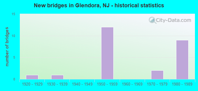
- New bridges - historical statistics
- 11920-1929
- 11930-1939
- 121950-1959
- 21970-1979
- 91980-1989

- Reconstructed bridges - Historical Statistics
- 12000-2009
- 12010-2019
- 22020-2022


- Bridge Condition - Deck
- 7.7%Very good
- 46.2%Good
- 23.1%Satisfactory
- 15.4%Fair
- 7.7%Poor

- Bridge Condition - Superstructure
- 7.7%Very good
- 69.2%Good
- 7.7%Satisfactory
- 7.7%Fair
- 7.7%Poor

- Bridge Condition - Substructure
- 23.1%Good
- 53.8%Satisfactory
- 23.1%Fair

- Bridge Condition - Channel
- 14.3%Very good
- 14.3%Good
- 42.9%Satisfactory
- 14.3%Fair
- 14.3%Poor

- Bridge Condition - Culverts
- 33.3%Good
- 66.7%Fair
Find on map >> Show street view
Structure Number: 407156, Location: 0.05 MI E OF RT 42 (Lat: 39.824069, Lng: -75.078789), Route carried "on" structure: City street , Year Built: 1980, Status: Open, Structure Length: 0.73m (2.40ft), Average Daily Traffic: 1,060 (year 2021), Truck Traffic: 4%, Average Future Daily Traffic: 1,272 (year 2041), Features Intersected: Stream, Facility Carried by Structure: Lakeview Dr
Minimum Vertical Clearance: 30+ m (98+ ft), Kilometerpoint: 0.000, Lanes on structure: 2, Owner: County Highway Agency, Approaching Roadway Width: 8.8m (28.9ft), Material/Design: Prestressed concrete, Design/Construction: Box Beam or Girders - Multiple, Number Of Spans In Main Unit: 1, Length of Maximum Span: 4.6m (15.1ft), Curb or Sidewalk Widths: Left: 0.5m (1.6ft), Right: 1.2m (3.9ft), Curb-To-Curb Width: 9.1m (29.9ft), Out-to-Out Width: 11.4m (37.4ft)
Condition: Deck: Satisfactory, Superstructure: Satisfactory, Substructure: Satisfactory, Channel: Poor, Operating Rating: 54.4 metric tons, Method Used To Determine Operating Rating: Field evaluation and documented engineering judgment, Inventory Rating: 32.7 metric tons, Method Used To Determine Inventory Rating: Field evaluation and documented engineering judgment, Structural Evaluation: Equal to present minimum criteria, Deck Geometry: Somewhat better than minimum adequacy, Waterway Adequacy: Equal to present minimum criteria, Approach Roadway Alignment: Equal to present desirable criteria, Designated Inspection Frequency: Every 24 months, Inspection Date: May 2021, Deck Structure Type: Concrete Cast-file-Place, Wearing Surface/Protective System: Wearing Surface: Monolithic Concrete
Find on map >> Show street view
Structure Number: 411163, Location: 0.5 MI S OF 42-41 JCT (Lat: 39.825581, Lng: -75.082819), Route carried "on" structure: State highway 42, Year Built: 1956, Status: Open, Structure Length: 1.71m (5.61ft), Average Daily Traffic: 65,984 (year 2021), Truck Traffic: 5%, Average Future Daily Traffic: 79,181 (year 2041), Design Load: HS 20, Features Intersected: CR681 (LOWER LANDING)
Minimum Vertical Clearance: 30+ m (98+ ft), Kilometerpoint: 17.735, Lanes on structure: 3, Lanes under structure: 2, Base Highway Network: Yes, Owner: State Highway Agency, Approaching Roadway Width: 15.5m (50.9ft), Material/Design: Steel, Design/Construction: Stringer/Multi-beam, Number Of Spans In Main Unit: 1, Length of Maximum Span: 15.8m (51.8ft), Curb or Sidewalk Widths: Left: 0.9m (3.0ft), Right: 0.9m (3.0ft), Curb-To-Curb Width: 15.5m (50.9ft), Out-to-Out Width: 18.0m (59.1ft)
Condition: Deck: Fair, Superstructure: Good, Substructure: Satisfactory, Operating Rating: 80.7 metric tons, Method Used To Determine Operating Rating: Load Factor (LF), Inventory Rating: 48.1 metric tons, Method Used To Determine Inventory Rating: Load Factor (LF), Structural Evaluation: Equal to present minimum criteria, Deck Geometry: Somewhat better than minimum adequacy, Underclear: Somewhat better than minimum adequacy, Approach Roadway Alignment: Equal to present desirable criteria, Designated Inspection Frequency: Every 24 months, Inspection Date: June 2021, Deck Structure Type: Concrete Cast-file-Place, Wearing Surface/Protective System: Wearing Surface: Bituminous, Membrane: Other
Find on map >> Show street view
Structure Number: 411164, Location: 0.5 MI S OF 42-41 JCT (Lat: 39.825381, Lng: -75.083089), Route carried "on" structure: State highway 42, Year Built: 1956, Year Reconstructed: 2019, Status: Open, Structure Length: 1.71m (5.61ft), Average Daily Traffic: 65,349 (year 2021), Truck Traffic: 5%, Average Future Daily Traffic: 78,419 (year 2041), Design Load: HS 20, Features Intersected: CR 681 (LOWER LANDING)
Minimum Vertical Clearance: 30+ m (98+ ft), Kilometerpoint: 17.735, Lanes on structure: 3, Lanes under structure: 2, Base Highway Network: Yes, Owner: State Highway Agency, Approaching Roadway Width: 15.5m (50.9ft), Material/Design: Steel, Design/Construction: Stringer/Multi-beam, Number Of Spans In Main Unit: 1, Length of Maximum Span: 15.8m (51.8ft), Curb or Sidewalk Widths: Left: 0.9m (3.0ft), Right: 0.9m (3.0ft), Curb-To-Curb Width: 15.5m (50.9ft), Out-to-Out Width: 18.0m (59.1ft)
Condition: Deck: Very good, Superstructure: Good, Substructure: Good, Operating Rating: 81.6 metric tons, Method Used To Determine Operating Rating: Load Factor (LF), Inventory Rating: 49.0 metric tons, Method Used To Determine Inventory Rating: Load Factor (LF), Structural Evaluation: Better than present minimum criteria, Deck Geometry: Somewhat better than minimum adequacy, Underclear: Somewhat better than minimum adequacy, Approach Roadway Alignment: Equal to present desirable criteria, Designated Inspection Frequency: Every 24 months, Inspection Date: June 2021, Deck Structure Type: Concrete Cast-file-Place, Wearing Surface/Protective System: Wearing Surface: Bituminous, Membrane: Other
Find on map >> Show street view
Structure Number: 411165, Location: .4 MILE SOUTH OF 41 JCT (Lat: 39.826231, Lng: -75.083700), Route carried "on" structure: State highway 42, Year Built: 1956, Year Reconstructed: 2020, Status: Open, Structure Length: 5.06m (16.60ft), Average Daily Traffic: 61,033 (year 2021), Truck Traffic: 5%, Average Future Daily Traffic: 73,240 (year 2041), Design Load: HL 93, Features Intersected: S. BR. BIG TIMBER CK.
Minimum Vertical Clearance: 30+ m (98+ ft), Kilometerpoint: 17.864, Lanes on structure: 3, Base Highway Network: Yes, Owner: State Highway Agency, Approaching Roadway Width: 16.9m (55.4ft), Material/Design: Steel continuous, Design/Construction: Stringer/Multi-beam, Number Of Spans In Main Unit: 2, Number Of Approach Spans: 1, Length of Maximum Span: 18.3m (60.0ft), Curb-To-Curb Width: 16.9m (55.4ft), Out-to-Out Width: 17.9m (58.7ft)
Condition: Deck: Good, Superstructure: Good, Substructure: Fair, Channel: Satisfactory, Operating Rating: 68.0 metric tons, Method Used To Determine Operating Rating: Field evaluation and documented engineering judgment, Inventory Rating: 40.8 metric tons, Method Used To Determine Inventory Rating: Field evaluation and documented engineering judgment, Structural Evaluation: Somewhat better than minimum adequacy, Deck Geometry: Equal to present minimum criteria, Waterway Adequacy: Superior to present desirable criteria, Approach Roadway Alignment: Equal to present desirable criteria, Designated Inspection Frequency: Every 24 months, Underwater Inspection Frequency: Every 48 months, Inspection Date: June 2021, Underwater Inspection Date: June 2021, Bridge Improvement Cost: $2,081,000, Roadway Improvement Cost: $112,000, Total Project Cost: $2,651,000 ( Estimate for 2019), Deck Structure Type: Concrete Cast-file-Place, Wearing Surface/Protective System: Wearing Surface: Monolithic Concrete, Deck Protection: Epoxy Coated Reinforcing
Find on map >> Show street view
Structure Number: 411166, Location: .4 MILE SOUTH OF 41 JCT (Lat: 39.826150, Lng: -75.084089), Route carried "on" structure: State highway 42, Year Built: 1956, Year Reconstructed: 2020, Status: Open, Structure Length: 5.06m (16.60ft), Average Daily Traffic: 61,033 (year 2021), Truck Traffic: 5%, Average Future Daily Traffic: 73,240 (year 2041), Design Load: HL 93, Features Intersected: S. BR. BIG TIMBER CREEK
Minimum Vertical Clearance: 30+ m (98+ ft), Kilometerpoint: 17.864, Lanes on structure: 3, Base Highway Network: Yes, Owner: State Highway Agency, Approaching Roadway Width: 16.9m (55.4ft), Material/Design: Steel continuous, Design/Construction: Stringer/Multi-beam, Number Of Spans In Main Unit: 2, Number Of Approach Spans: 1, Length of Maximum Span: 18.3m (60.0ft), Curb-To-Curb Width: 16.9m (55.4ft), Out-to-Out Width: 17.9m (58.7ft)
Condition: Deck: Good, Superstructure: Good, Substructure: Fair, Channel: Very good, Operating Rating: 68.0 metric tons, Method Used To Determine Operating Rating: Field evaluation and documented engineering judgment, Inventory Rating: 40.8 metric tons, Method Used To Determine Inventory Rating: Field evaluation and documented engineering judgment, Structural Evaluation: Somewhat better than minimum adequacy, Deck Geometry: Equal to present minimum criteria, Waterway Adequacy: Superior to present desirable criteria, Approach Roadway Alignment: Equal to present desirable criteria, Designated Inspection Frequency: Every 24 months, Inspection Date: June 2021, Bridge Improvement Cost: $2,081,000, Roadway Improvement Cost: $112,000, Total Project Cost: $2,651,000 ( Estimate for 2019), Deck Structure Type: Concrete Cast-file-Place, Wearing Surface/Protective System: Wearing Surface: Monolithic Concrete, Deck Protection: Epoxy Coated Reinforcing
Find on map >> Show street view
Structure Number: 46C021, Location: .27 MI E OF CR 683 Somerd (Lat: 39.835911, Lng: -75.060431), Route carried "on" structure: County highway 677, Year Built: 1936, Status: Open, Structure Length: 0.73m (2.40ft), Average Daily Traffic: 17,318 (year 2021), Truck Traffic: 3%, Average Future Daily Traffic: 20,782 (year 2041), Features Intersected: N BRANCH TIMBER CREEK, Facility Carried by Structure: SOMERDALE ROAD
Minimum Vertical Clearance: 30+ m (98+ ft), Kilometerpoint: 0.435, Lanes on structure: 2, Owner: County Highway Agency, Approaching Roadway Width: 10.7m (35.1ft), Material/Design: Concrete, Design/Construction: Frame, Number Of Spans In Main Unit: 1, Length of Maximum Span: 6.1m (20.0ft), Curb or Sidewalk Widths: Left: 2.3m (7.5ft), Right: 2.2m (7.2ft), Curb-To-Curb Width: 10.8m (35.4ft), Out-to-Out Width: 16.0m (52.5ft)
Condition: Deck: Poor, Superstructure: Poor, Substructure: Fair, Channel: Satisfactory, Operating Rating: 49.9 metric tons, Method Used To Determine Operating Rating: Load Factor (LF), Inventory Rating: 29.9 metric tons, Method Used To Determine Inventory Rating: Load Factor (LF), Structural Evaluation: Meets minimum limits, Deck Geometry: Meets minimum limits, Waterway Adequacy: Better than present minimum criteria, Approach Roadway Alignment: Equal to present desirable criteria, Length Of Structure Improvement: 0.73m (2.40ft), Designated Inspection Frequency: Every 24 months, Underwater Inspection Frequency: Every 48 months, Inspection Date: Febuary 2021, Underwater Inspection Date: Febuary 2021, Bridge Improvement Cost: $142,000, Roadway Improvement Cost: $45,000, Total Project Cost: $262,000 ( Estimate for 2021), Deck Structure Type: Concrete Cast-file-Place, Wearing Surface/Protective System: Wearing Surface: Bituminous
Find on map >> Show street view
Structure Number: 80215, Location: 3.8 MILE S. OF 295 JCT. (Lat: 39.830831, Lng: -75.089000), Route carried "on" structure: State highway 41, Year Built: 1955, Year Reconstructed: 2005, Status: Open, Structure Length: 8.50m (27.89ft), Average Daily Traffic: 22,583 (year 2021), Truck Traffic: 4%, Average Future Daily Traffic: 27,552 (year 2041), Design Load: HS 20, Features Intersected: NJ 42
Minimum Vertical Clearance: 30+ m (98+ ft), Kilometerpoint: 5.456, Lanes on structure: 3, Lanes under structure: 7, Owner: State Highway Agency, Approaching Roadway Width: 14.0m (45.9ft), Skew: 3 degrees, Material/Design: Steel, Design/Construction: Stringer/Multi-beam, Number Of Spans In Main Unit: 3, Length of Maximum Span: 32.3m (106.0ft), Curb or Sidewalk Widths: Left: 1.8m (5.9ft), Right: 1.8m (5.9ft), Curb-To-Curb Width: 14.0m (45.9ft), Out-to-Out Width: 18.3m (60.0ft)
Condition: Deck: Good, Superstructure: Good, Substructure: Satisfactory, Inventory Rating: 61.7 metric tons, Method Used To Determine Inventory Rating: Load Factor (LF), Structural Evaluation: Equal to present minimum criteria, Deck Geometry: Somewhat better than minimum adequacy, Underclear: High priority of corrective action, Approach Roadway Alignment: Equal to present desirable criteria, Length Of Structure Improvement: 8.50m (27.89ft), Designated Inspection Frequency: Every 24 months, Inspection Date: May 2021, Roadway Improvement Cost: $185,000, Total Project Cost: $203,000 ( Estimate for 2019), Deck Structure Type: Concrete Cast-file-Place, Wearing Surface/Protective System: Wearing Surface: Monolithic Concrete, Deck Protection: Epoxy Coated Reinforcing
Find on map >> Show street view
Structure Number: 802K02, Location: 0.43 MILES EAST OF CR 621 (Lat: 39.835439, Lng: -75.094781), Route carried "on" structure: County highway 544, Year Built: 1974, Status: Open, Structure Length: 0.61m (2.00ft), Average Daily Traffic: 20,124 (year 2020), Truck Traffic: 4%, Average Future Daily Traffic: 24,149 (year 2040), Design Load: HS 20, Features Intersected: ALMONESSON CREEK
Minimum Vertical Clearance: 30+ m (98+ ft), Kilometerpoint: 2.269, Lanes on structure: 7, Base Highway Network: Yes, Owner: County Highway Agency, Approaching Roadway Width: 31.9m (104.7ft), Skew: 30 degrees, Material/Design: Concrete, Design/Construction: Culvert, Number Of Spans In Main Unit: 1, Length of Maximum Span: 6.1m (20.0ft), Curb or Sidewalk Widths: Left: 1.5m (4.9ft), Right: 0.0m
Condition: Channel: Satisfactory, Culverts: Fair, Operating Rating: 89.8 metric tons, Method Used To Determine Operating Rating: Load Factor (LF), Inventory Rating: 58.1 metric tons, Method Used To Determine Inventory Rating: Load Factor (LF), Structural Evaluation: Somewhat better than minimum adequacy, Waterway Adequacy: Equal to present minimum criteria, Approach Roadway Alignment: Equal to present desirable criteria, Designated Inspection Frequency: Every 24 months, Inspection Date: April 2020
Find on map >> Show street view
Structure Number: 803K03, Location: 0.3 MI WEST OF NJ RT 41 (Lat: 39.818039, Lng: -75.096550), Route carried "on" structure: County highway 706, Year Built: 1926, Status: Open, Structure Length: 0.61m (2.00ft), Average Daily Traffic: 8,920 (year 2020), Truck Traffic: 4%, Average Future Daily Traffic: 10,704 (year 2040), Features Intersected: ALMONESSON CREEK
Minimum Vertical Clearance: 30+ m (98+ ft), Kilometerpoint: 1.770, Lanes on structure: 2, Owner: County Highway Agency, Approaching Roadway Width: 9.4m (30.8ft), Material/Design: Concrete, Design/Construction: Culvert, Number Of Spans In Main Unit: 1, Length of Maximum Span: 6.1m (20.0ft), Curb or Sidewalk Widths: Left: 1.9m (6.2ft), Right: 1.9m (6.2ft), Curb-To-Curb Width: 9.1m (29.9ft), Out-to-Out Width: 14.0m (45.9ft)
Condition: Channel: Fair, Culverts: Fair, Inventory Rating: 89.8 metric tons, Method Used To Determine Inventory Rating: Load Factor (LF), Structural Evaluation: Somewhat better than minimum adequacy, Deck Geometry: High priority of corrective action, Waterway Adequacy: Equal to present minimum criteria, Approach Roadway Alignment: Equal to present desirable criteria, Length Of Structure Improvement: 0.61m (2.00ft), Designated Inspection Frequency: Every 24 months, Inspection Date: April 2020, Bridge Improvement Cost: $41,000, Roadway Improvement Cost: $100,000, Total Project Cost: $216,000 ( Estimate for 2020)
Find on map >> Show street view
Structure Number: 803K12, Location: 0.29 MI W OF NJ RT 41 (Lat: 39.828169, Lng: -75.094969), Route carried "on" structure: City street , Year Built: 1975, Status: Open, Structure Length: 0.94m (3.08ft), Average Daily Traffic: 14,465 (year 2020), Truck Traffic: 3%, Average Future Daily Traffic: 17,358 (year 2040), Features Intersected: ALMONESSON CREEK, Facility Carried by Structure: DEPTFORD CTR ROAD
Minimum Vertical Clearance: 30+ m (98+ ft), Kilometerpoint: 0.789, Lanes on structure: 4, Owner: County Highway Agency, Approaching Roadway Width: 16.8m (55.1ft), Skew: 1 degrees, Material/Design: Concrete, Design/Construction: Culvert, Number Of Spans In Main Unit: 1, Length of Maximum Span: 9.4m (30.8ft), Curb or Sidewalk Widths: Left: 1.2m (3.9ft), Right: 0.0m
Condition: Channel: Good, Culverts: Good, Operating Rating: 89.8 metric tons, Method Used To Determine Operating Rating: Load Factor (LF), Inventory Rating: 53.5 metric tons, Method Used To Determine Inventory Rating: Load Factor (LF), Structural Evaluation: Better than present minimum criteria, Waterway Adequacy: Better than present minimum criteria, Approach Roadway Alignment: Equal to present desirable criteria, Designated Inspection Frequency: Every 24 months, Inspection Date: April 2020
Find on map >> Show street view
Structure Number: 80415, Location: 0.41 MI N OF NJ RT 41 (Lat: 39.836889, Lng: -75.091561), Route carried "on" structure: State highway 42, Year Built: 1956, Status: Open, Structure Length: 1.83m (6.00ft), Average Daily Traffic: 67,651 (year 2020), Truck Traffic: 5%, Average Future Daily Traffic: 81,182 (year 2040), Design Load: HS 20, Features Intersected: CLEMENTS BR RD RT 544
Minimum Vertical Clearance: 30.45m (99.90ft), Kilometerpoint: 19.232, Lanes on structure: 3, Lanes under structure: 4, Base Highway Network: Yes, Owner: State Highway Agency, Approaching Roadway Width: 15.5m (50.9ft), Skew: 1 degrees, Material/Design: Steel, Design/Construction: Stringer/Multi-beam, Number Of Spans In Main Unit: 1, Length of Maximum Span: 16.8m (55.1ft), Curb or Sidewalk Widths: Left: 0.9m (3.0ft), Right: 0.9m (3.0ft), Curb-To-Curb Width: 15.5m (50.9ft), Out-to-Out Width: 18.0m (59.1ft)
Condition: Deck: Satisfactory, Superstructure: Fair, Substructure: Satisfactory, Operating Rating: 71.7 metric tons, Method Used To Determine Operating Rating: Load Factor (LF), Inventory Rating: 43.5 metric tons, Method Used To Determine Inventory Rating: Load Factor (LF), Structural Evaluation: Somewhat better than minimum adequacy, Deck Geometry: Somewhat better than minimum adequacy, Underclear: High priority of replacement, Approach Roadway Alignment: Equal to present desirable criteria, Length Of Structure Improvement: 2.56m (8.40ft), Designated Inspection Frequency: Every 24 months, Inspection Date: August 2020, Bridge Improvement Cost: $1,982,000, Roadway Improvement Cost: $198,000, Total Project Cost: $2,850,000 ( Estimate for 2020), Deck Structure Type: Concrete Cast-file-Place, Wearing Surface/Protective System: Wearing Surface: Monolithic Concrete
Find on map >> Show street view
Structure Number: 804151, Location: 0.41 MI N OF NJ RT 41 (Lat: 39.836750, Lng: -75.092061), Route carried "on" structure: State highway 42, Year Built: 1956, Status: Open, Structure Length: 1.80m (5.91ft), Average Daily Traffic: 67,679 (year 2020), Truck Traffic: 5%, Average Future Daily Traffic: 81,214 (year 2040), Design Load: HS 20, Features Intersected: CLEMENTS BR RD RT 544
Minimum Vertical Clearance: 30+ m (98+ ft), Kilometerpoint: 19.232, Lanes on structure: 3, Lanes under structure: 4, Base Highway Network: Yes, Owner: State Highway Agency, Approaching Roadway Width: 16.2m (53.1ft), Skew: 1 degrees, Material/Design: Steel, Design/Construction: Stringer/Multi-beam, Number Of Spans In Main Unit: 1, Length of Maximum Span: 16.8m (55.1ft), Curb or Sidewalk Widths: Left: 0.9m (3.0ft), Right: 0.9m (3.0ft), Curb-To-Curb Width: 16.2m (53.1ft), Out-to-Out Width: 18.6m (61.0ft)
Condition: Deck: Fair, Superstructure: Good, Substructure: Satisfactory, Operating Rating: 72.6 metric tons, Method Used To Determine Operating Rating: Load Factor (LF), Inventory Rating: 43.5 metric tons, Method Used To Determine Inventory Rating: Load Factor (LF), Structural Evaluation: Equal to present minimum criteria, Deck Geometry: Equal to present minimum criteria, Underclear: High priority of replacement, Approach Roadway Alignment: Equal to present desirable criteria, Length Of Structure Improvement: 2.50m (8.20ft), Designated Inspection Frequency: Every 24 months, Inspection Date: August 2020, Bridge Improvement Cost: $1,896,000, Roadway Improvement Cost: $184,000, Total Project Cost: $2,925,000 ( Estimate for 2018), Deck Structure Type: Concrete Cast-file-Place, Wearing Surface/Protective System: Wearing Surface: Bituminous
Find on map >> Show street view
Structure Number: 83215, Location: 1.55 MILES SOUTH OF RT 42 (Lat: 39.828181, Lng: -75.104850), Route carried "on" structure: Ramp City street , Year Built: 1985, Status: Open, Structure Length: 9.81m (32.19ft), Average Daily Traffic: 1,552 (year 2021), Truck Traffic: 3%, Average Future Daily Traffic: 1,863 (year 2041), Design Load: HS 20, Features Intersected: NJ 55, Facility Carried by Structure: DEPTFORD CENTER RD
Minimum Vertical Clearance: 30+ m (98+ ft), Kilometerpoint: 0.000, Lanes on structure: 2, Lanes under structure: 5, Owner: State Highway Agency, Approaching Roadway Width: 17.7m (58.1ft), Skew: 30 degrees, Material/Design: Steel, Design/Construction: Stringer/Multi-beam, Number Of Spans In Main Unit: 3, Length of Maximum Span: 38.7m (127.0ft), Curb-To-Curb Width: 17.7m (58.1ft), Out-to-Out Width: 19.4m (63.6ft)
Condition: Deck: Good, Superstructure: Good, Substructure: Satisfactory, Operating Rating: 89.8 metric tons, Method Used To Determine Operating Rating: Load Factor (LF), Inventory Rating: 63.5 metric tons, Method Used To Determine Inventory Rating: Load Factor (LF), Structural Evaluation: Equal to present minimum criteria, Deck Geometry: Superior to present desirable criteria, Underclear: Equal to present minimum criteria, Approach Roadway Alignment: Equal to present desirable criteria, Designated Inspection Frequency: Every 24 months, Inspection Date: March 2021, Deck Structure Type: Concrete Cast-file-Place, Wearing Surface/Protective System: Wearing Surface: Monolithic Concrete, Deck Protection: Epoxy Coated Reinforcing
Find on map >> Show street view
Structure Number: 832151, Location: 1.3 MI SOUTH JCT 42 & 55 (Lat: 39.831739, Lng: -75.104281), Route carried "on" structure: County highway 544, Year Built: 1985, Status: Open, Structure Length: 11.55m (37.89ft), Average Daily Traffic: 20,539 (year 2022), Truck Traffic: 4%, Average Future Daily Traffic: 25,061 (year 2042), Design Load: HS 20+Mod, Features Intersected: NJ 55, Facility Carried by Structure: CLEMENTS BRIDGE RD
Minimum Vertical Clearance: 30+ m (98+ ft), Kilometerpoint: 1.368, Lanes on structure: 4, Lanes under structure: 4, Base Highway Network: Yes, Owner: State Highway Agency, Approaching Roadway Width: 17.1m (56.1ft), Skew: 33 degrees, Material/Design: Steel, Design/Construction: Stringer/Multi-beam, Number Of Spans In Main Unit: 3, Length of Maximum Span: 42.7m (140.1ft), Curb or Sidewalk Widths: Left: 1.8m (5.9ft), Right: 1.8m (5.9ft), Curb-To-Curb Width: 17.1m (56.1ft), Out-to-Out Width: 26.2m (86.0ft)
Condition: Deck: Satisfactory, Superstructure: Good, Substructure: Good, Operating Rating: 77.1 metric tons, Method Used To Determine Operating Rating: Load Factor (LF), Inventory Rating: 46.3 metric tons, Method Used To Determine Inventory Rating: Load Factor (LF), Structural Evaluation: Better than present minimum criteria, Deck Geometry: Somewhat better than minimum adequacy, Underclear: Somewhat better than minimum adequacy, Approach Roadway Alignment: Equal to present desirable criteria, Designated Inspection Frequency: Every 24 months, Inspection Date: Febuary 2020, Deck Structure Type: Concrete Cast-file-Place, Wearing Surface/Protective System: Wearing Surface: Monolithic Concrete, Deck Protection: Epoxy Coated Reinforcing
Find on map >> Show street view
Structure Number: 832152, Location: 0.55 MI NORTH OF EXIT 58 (Lat: 39.835489, Lng: -75.101519), Route carried "on" structure: County highway 621, Year Built: 1985, Status: Open, Structure Length: 11.80m (38.71ft), Average Daily Traffic: 14,430 (year 2022), Truck Traffic: 4%, Average Future Daily Traffic: 17,607 (year 2042), Design Load: HS 20+Mod, Features Intersected: NJ ROUTE 55, Facility Carried by Structure: ALMONESSON ROAD
Minimum Vertical Clearance: 30+ m (98+ ft), Kilometerpoint: 6.373, Lanes on structure: 4, Lanes under structure: 4, Owner: State Highway Agency, Approaching Roadway Width: 15.2m (49.9ft), Skew: 4 degrees, Material/Design: Steel, Design/Construction: Stringer/Multi-beam, Number Of Spans In Main Unit: 3, Length of Maximum Span: 45.4m (149.0ft), Curb or Sidewalk Widths: Left: 1.8m (5.9ft), Right: 1.8m (5.9ft), Curb-To-Curb Width: 15.2m (49.9ft), Out-to-Out Width: 19.5m (64.0ft)
Condition: Deck: Good, Superstructure: Good, Substructure: Satisfactory, Inventory Rating: 68.9 metric tons, Method Used To Determine Inventory Rating: Load Factor (LF), Structural Evaluation: Equal to present minimum criteria, Deck Geometry: High priority of corrective action, Underclear: Equal to present minimum criteria, Approach Roadway Alignment: Better than present minimum criteria, Designated Inspection Frequency: Every 24 months, Inspection Date: Febuary 2020, Deck Structure Type: Concrete Cast-file-Place, Wearing Surface/Protective System: Wearing Surface: Monolithic Concrete, Deck Protection: Epoxy Coated Reinforcing
Find on map >> Show street view
Structure Number: 832165, Location: 0.4 MI S OF RT 55 EXIT 58 (Lat: 39.821389, Lng: -75.105519), Route carried "on" structure: County highway 706, Year Built: 1985, Status: Open, Structure Length: 9.60m (31.50ft), Average Daily Traffic: 8,969 (year 2019), Truck Traffic: 4%, Average Future Daily Traffic: 10,944 (year 2039), Design Load: HS 20+Mod, Features Intersected: ROUTE NJ 55
Minimum Vertical Clearance: 30+ m (98+ ft), Kilometerpoint: 0.982, Lanes on structure: 2, Lanes under structure: 4, Owner: State Highway Agency, Approaching Roadway Width: 15.2m (49.9ft), Skew: 1 degrees, Material/Design: Steel continuous, Design/Construction: Stringer/Multi-beam, Number Of Spans In Main Unit: 3, Length of Maximum Span: 38.1m (125.0ft), Curb or Sidewalk Widths: Left: 1.8m (5.9ft), Right: 1.8m (5.9ft), Curb-To-Curb Width: 15.2m (49.9ft), Out-to-Out Width: 19.5m (64.0ft)
Condition: Deck: Good, Superstructure: Very good, Substructure: Good, Inventory Rating: 56.2 metric tons, Method Used To Determine Inventory Rating: Load Factor (LF), Structural Evaluation: Better than present minimum criteria, Deck Geometry: Superior to present desirable criteria, Underclear: Equal to present minimum criteria, Approach Roadway Alignment: Equal to present desirable criteria, Designated Inspection Frequency: Every 24 months, Inspection Date: August 2021, Deck Structure Type: Concrete Cast-file-Place, Wearing Surface/Protective System: Wearing Surface: Monolithic Concrete, Deck Protection: Epoxy Coated Reinforcing
Find on map >> Show street view
Structure Number: 411163, Location: 0.5 MI S OF 42-41 JCT (Lat: 39.825581, Lng: -75.082819), Route carried "under" structure: County highway 681, Year Built: 1956, Structure Length: 0. m, Average Daily Traffic: 6,452 (year 2019), Truck Traffic: 4%, Features Intersected: CR681 (LOWER LANDING), Facility Carried by Structure: NJ 42 NB
Minimum Vertical Clearance: 4.95m (16.24ft), Kilometerpoint: 2.398, Lanes on structure: 3, Lanes under structure: 2, Material/Design: Steel, Design/Construction: Stringer/Multi-beam, Length of Maximum Span: 15.8m (51.8ft)
Find on map >> Show street view
Structure Number: 411164, Location: 0.5 MI S OF 42-41 JCT (Lat: 39.825381, Lng: -75.083089), Route carried "under" structure: County highway 681, Year Built: 1956, Structure Length: 0. m, Average Daily Traffic: 6,646 (year 2021), Truck Traffic: 4%, Features Intersected: CR 681 (LOWER LANDING), Facility Carried by Structure: NJ 42 SB
Minimum Vertical Clearance: 4.52m (14.83ft), Kilometerpoint: 2.398, Lanes on structure: 3, Lanes under structure: 2, Material/Design: Steel, Design/Construction: Stringer/Multi-beam, Length of Maximum Span: 15.8m (51.8ft)
Find on map >> Show street view
Structure Number: 80215, Location: 3.8 MILE S. OF 295 JCT. (Lat: 39.830831, Lng: -75.089000), Route carried "under" structure: State highway 42, Year Built: 1955, Structure Length: 0. m, Average Daily Traffic: 114,447 (year 2021), Truck Traffic: 5%, Features Intersected: NJ 42, Facility Carried by Structure: NJ 41
Minimum Vertical Clearance: 4.69m (15.39ft), Kilometerpoint: 18.572, Lanes on structure: 3, Lanes under structure: 7, Material/Design: Steel, Design/Construction: Stringer/Multi-beam, Length of Maximum Span: 32.3m (106.0ft)
Find on map >> Show street view
Structure Number: 80415, Location: 0.41 MI N OF NJ RT 41 (Lat: 39.836889, Lng: -75.091561), Route carried "under" structure: County highway 544, Year Built: 1956, Structure Length: 0. m, Average Daily Traffic: 18,397 (year 2020), Truck Traffic: 4%, Features Intersected: CLEMENTS BR RD RT 544, Facility Carried by Structure: NJ 42 NB
Minimum Vertical Clearance: 4.65m (15.26ft), Kilometerpoint: 2.591, Lanes on structure: 3, Lanes under structure: 4, Material/Design: Steel, Design/Construction: Stringer/Multi-beam, Length of Maximum Span: 16.8m (55.1ft)
Find on map >> Show street view
Structure Number: 804151, Location: 0.41 MI N OF NJ RT 41 (Lat: 39.836750, Lng: -75.092061), Route carried "under" structure: County highway 544, Year Built: 1956, Structure Length: 0. m, Average Daily Traffic: 18,401 (year 2020), Truck Traffic: 4%, Features Intersected: CLEMENTS BR RD RT 544, Facility Carried by Structure: RT NJ 42 SB
Minimum Vertical Clearance: 4.55m (14.93ft), Kilometerpoint: 2.559, Lanes on structure: 3, Lanes under structure: 4, Material/Design: Steel, Design/Construction: Stringer/Multi-beam, Length of Maximum Span: 16.8m (55.1ft)
Find on map >> Show street view
Structure Number: 83215, Location: 1.55 MILES SOUTH OF RT 42 (Lat: 39.828181, Lng: -75.104850), Route carried "under" structure: State highway 55, Year Built: 1985, Structure Length: 0. m, Average Daily Traffic: 75,727 (year 2021), Truck Traffic: 5%, Features Intersected: NJ 55, Facility Carried by Structure: DEPTFORD CENTER RD
Minimum Vertical Clearance: 5.21m (17.09ft), Kilometerpoint: 94.790, Lanes on structure: 2, Lanes under structure: 5, Material/Design: Steel, Design/Construction: Stringer/Multi-beam, Length of Maximum Span: 38.7m (127.0ft)
Find on map >> Show street view
Structure Number: 832151, Location: 1.3 MI SOUTH JCT 42 & 55 (Lat: 39.831739, Lng: -75.104281), Route carried "under" structure: State highway 55, Year Built: 1985, Structure Length: 0. m, Average Daily Traffic: 78,825 (year 2022), Truck Traffic: 5%, Features Intersected: NJ 55, Facility Carried by Structure: CLEMENTS BRIDGE RD
Minimum Vertical Clearance: 5.36m (17.59ft), Kilometerpoint: 95.193, Lanes on structure: 4, Lanes under structure: 4, Material/Design: Steel, Design/Construction: Stringer/Multi-beam, Length of Maximum Span: 42.7m (140.1ft)
Find on map >> Show street view
Structure Number: 832152, Location: 0.55 MI NORTH OF EXIT 58 (Lat: 39.835489, Lng: -75.101519), Route carried "under" structure: State highway 55, Year Built: 1985, Structure Length: 0. m, Average Daily Traffic: 78,826 (year 2022), Truck Traffic: 5%, Features Intersected: NJ ROUTE 55, Facility Carried by Structure: ALMONESSON ROAD
Minimum Vertical Clearance: 5.22m (17.13ft), Kilometerpoint: 95.676, Lanes on structure: 4, Lanes under structure: 4, Material/Design: Steel, Design/Construction: Stringer/Multi-beam, Length of Maximum Span: 45.4m (149.0ft)
Find on map >> Show street view
Structure Number: 832165, Location: 0.4 MI S OF RT 55 EXIT 58 (Lat: 39.821389, Lng: -75.105519), Route carried "under" structure: State highway 55, Year Built: 1985, Structure Length: 0. m, Average Daily Traffic: 72,275 (year 2019), Truck Traffic: 5%, Features Intersected: ROUTE NJ 55, Facility Carried by Structure: COOPER ST(CO. 706)
Minimum Vertical Clearance: 5.51m (18.08ft), Kilometerpoint: 94.002, Lanes on structure: 2, Lanes under structure: 4, Material/Design: Steel continuous, Design/Construction: Stringer/Multi-beam, Length of Maximum Span: 38.1m (125.0ft)