Bridge Statistics for Gloucester City, New Jersey (NJ)
Condition, Traffic, Stress, Structural Evaluation, Project Costs
- National Bridge Inventory (NBI) Statistics
- 23Number of bridges
- 1,299ft / 396mTotal length
- $219,888,000Total costs
- 1,230,792Total average daily traffic
- 99,146Total average daily truck traffic
- National Bridge Inventory (NBI) Registered Bridges for Gloucester City
- No street view available for this location
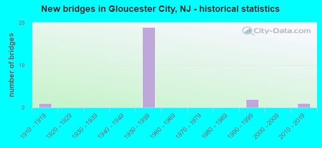
- New bridges - historical statistics
- 11910-1919
- 191950-1959
- 21990-1999
- 12010-2019

- Reconstructed bridges - Historical Statistics
- 11990-1999
- 22000-2009


- Bridge Condition - Deck
- 38.5%Good
- 30.8%Satisfactory
- 15.4%Fair
- 7.7%Poor
- 7.7%Serious

- Bridge Condition - Superstructure
- 7.1%Very good
- 42.9%Good
- 35.7%Satisfactory
- 7.1%Fair
- 7.1%Poor

- Bridge Condition - Substructure
- 7.1%Very good
- 35.7%Good
- 42.9%Satisfactory
- 14.3%Fair

- Bridge Condition - Channel
- 14.3%Excellent
- 14.3%Very good
- 57.1%Good
- 14.3%Fair
Find on map >> Show street view
Structure Number: 417152, Location: 0.15 MI N OF 76-295 JCT (Lat: 39.878281, Lng: -75.102381), Route carried "on" structure: Interstate 76, Year Built: 1956, Year Reconstructed: 2008, Status: Open, Structure Length: 2.29m (7.51ft), Average Daily Traffic: 209,722 (year 2021), Truck Traffic: 9%, Average Future Daily Traffic: 251,666 (year 2041), Design Load: HL 93, Features Intersected: KINGS HIGHWAY(CO.551S)
Minimum Vertical Clearance: 30+ m (98+ ft), Kilometerpoint: 0.729, Lanes on structure: 12, Lanes under structure: 2, Base Highway Network: Yes, Owner: State Highway Agency, Approaching Roadway Width: 58.5m (191.9ft), Skew: 30 degrees, Material/Design: Steel, Design/Construction: Stringer/Multi-beam, Number Of Spans In Main Unit: 1, Length of Maximum Span: 21.0m (68.9ft), Curb-To-Curb Width: 58.5m (191.9ft), Out-to-Out Width: 62.9m (206.4ft)
Condition: Deck: Good, Superstructure: Good, Substructure: Good, Operating Rating: 63.5 metric tons, Method Used To Determine Operating Rating: Load and Resistance Factor Rating (LRFR) rating reported by rating factor(RF) method using HL-93 loadings, Inventory Rating: 62.2 metric tons, Method Used To Determine Inventory Rating: Load and Resistance Factor Rating (LRFR) rating reported by rating factor(RF) method using HL-93 loadings, Structural Evaluation: Better than present minimum criteria, Deck Geometry: Superior to present desirable criteria, Underclear: High priority of corrective action, Approach Roadway Alignment: Equal to present desirable criteria, Length Of Structure Improvement: 2.29m (7.51ft), Designated Inspection Frequency: Every 24 months, Inspection Date: June 2021, Roadway Improvement Cost: $520,000, Total Project Cost: $718,000 ( Estimate for 2021), Deck Structure Type: Concrete Cast-file-Place, Wearing Surface/Protective System: Wearing Surface: Monolithic Concrete
Find on map >> Show street view
Structure Number: 417153, Location: 0.2 MI S OF US 130 JCT (Lat: 39.883900, Lng: -75.103939), Route carried "on" structure: County highway 634, Year Built: 1956, Status: Open, Structure Length: 7.38m (24.21ft), Average Daily Traffic: 7,770 (year 2019), Truck Traffic: 4%, Average Future Daily Traffic: 10,900 (year 2039), Design Load: HS 20, Features Intersected: I-76
Minimum Vertical Clearance: 30+ m (98+ ft), Kilometerpoint: 2.559, Lanes on structure: 2, Lanes under structure: 11, Owner: State Highway Agency, Approaching Roadway Width: 12.2m (40.0ft), Skew: 4 degrees, Material/Design: Steel, Design/Construction: Stringer/Multi-beam, Number Of Spans In Main Unit: 2, Length of Maximum Span: 38.1m (125.0ft), Curb or Sidewalk Widths: Left: 1.8m (5.9ft), Right: 1.8m (5.9ft), Curb-To-Curb Width: 12.2m (40.0ft), Out-to-Out Width: 16.5m (54.1ft)
Condition: Deck: Fair, Superstructure: Satisfactory, Substructure: Satisfactory, Operating Rating: 66.2 metric tons, Method Used To Determine Operating Rating: Load Factor (LF), Inventory Rating: 39.0 metric tons, Method Used To Determine Inventory Rating: Load Factor (LF), Structural Evaluation: Equal to present minimum criteria, Deck Geometry: Somewhat better than minimum adequacy, Underclear: High priority of corrective action, Approach Roadway Alignment: Better than present minimum criteria, Length Of Structure Improvement: 3.05m (10.01ft), Designated Inspection Frequency: Every 24 months, Inspection Date: October 2021, Roadway Improvement Cost: $39,000, Total Project Cost: $46,000 ( Estimate for 2021), Deck Structure Type: Concrete Cast-file-Place, Wearing Surface/Protective System: Wearing Surface: Monolithic Concrete
Find on map >> Show street view
Structure Number: 417154, Location: 1.0 MILL SOUTH OF RT 47 (Lat: 39.885611, Lng: -75.105011), Route carried "on" structure: Ramp Interstate 76, Year Built: 1956, Status: Open, Structure Length: 1.49m (4.89ft), Average Daily Traffic: 9,743 (year 2021), Truck Traffic: 9%, Average Future Daily Traffic: 11,887 (year 2041), Design Load: HS 20, Features Intersected: US 130 NB
Minimum Vertical Clearance: 30+ m (98+ ft), Kilometerpoint: 1.577, Lanes on structure: 1, Lanes under structure: 2, Owner: State Highway Agency, Approaching Roadway Width: 10.7m (35.1ft), Material/Design: Steel, Design/Construction: Stringer/Multi-beam, Number Of Spans In Main Unit: 1, Length of Maximum Span: 13.7m (44.9ft), Curb-To-Curb Width: 10.7m (35.1ft), Out-to-Out Width: 12.2m (40.0ft)
Condition: Deck: Satisfactory, Superstructure: Good, Substructure: Good, Operating Rating: 81.6 metric tons, Method Used To Determine Operating Rating: Load Factor (LF), Inventory Rating: 49.0 metric tons, Method Used To Determine Inventory Rating: Load Factor (LF), Structural Evaluation: Better than present minimum criteria, Deck Geometry: Superior to present desirable criteria, Underclear: Equal to present minimum criteria, Approach Roadway Alignment: Equal to present desirable criteria, Designated Inspection Frequency: Every 24 months, Inspection Date: October 2021, Deck Structure Type: Concrete Cast-file-Place, Wearing Surface/Protective System: Wearing Surface: Latex Concrete
Find on map >> Show street view
Structure Number: 417155, Location: 1.1 MI E OF 76-676 JCT (Lat: 39.885961, Lng: -75.104350), Route carried "on" structure: Interstate 76, Year Built: 1956, Year Reconstructed: 1995, Status: Open, Structure Length: 1.86m (6.10ft), Average Daily Traffic: 149,316 (year 2019), Truck Traffic: 9%, Average Future Daily Traffic: 182,375 (year 2039), Design Load: HS 20, Features Intersected: US 130 NB
Minimum Vertical Clearance: 30+ m (98+ ft), Kilometerpoint: 1.577, Lanes on structure: 10, Lanes under structure: 2, Base Highway Network: Yes, Owner: State Highway Agency, Approaching Roadway Width: 44.5m (146.0ft), Skew: 33 degrees, Material/Design: Steel, Design/Construction: Stringer/Multi-beam, Number Of Spans In Main Unit: 1, Length of Maximum Span: 17.7m (58.1ft), Curb-To-Curb Width: 44.5m (146.0ft), Out-to-Out Width: 48.2m (158.1ft)
Condition: Deck: Satisfactory, Superstructure: Fair, Substructure: Satisfactory, Operating Rating: 68.9 metric tons, Method Used To Determine Operating Rating: Load Factor (LF), Inventory Rating: 40.8 metric tons, Method Used To Determine Inventory Rating: Load Factor (LF), Structural Evaluation: Somewhat better than minimum adequacy, Deck Geometry: Superior to present desirable criteria, Underclear: Equal to present minimum criteria, Approach Roadway Alignment: Equal to present desirable criteria, Designated Inspection Frequency: Every 24 months, Inspection Date: October 2021, Deck Structure Type: Concrete Cast-file-Place, Wearing Surface/Protective System: Wearing Surface: Latex Concrete
Find on map >> Show street view
Structure Number: 417156, Location: 0.7 MILE S OF 295-130JCT (Lat: 39.889539, Lng: -75.104619), Route carried "on" structure: Ramp Interstate 76, Year Built: 1956, Status: Open, Structure Length: 1.95m (6.40ft), Average Daily Traffic: 7,546 (year 2019), Truck Traffic: 9%, Average Future Daily Traffic: 9,208 (year 2039), Design Load: HS 20, Features Intersected: US 130 SB
Minimum Vertical Clearance: 30+ m (98+ ft), Kilometerpoint: 1.851, Lanes on structure: 1, Lanes under structure: 3, Owner: State Highway Agency, Approaching Roadway Width: 7.6m (24.9ft), Skew: 3 degrees, Material/Design: Steel, Design/Construction: Stringer/Multi-beam, Number Of Spans In Main Unit: 1, Length of Maximum Span: 18.3m (60.0ft), Curb or Sidewalk Widths: Left: 0.5m (1.6ft), Right: 0.9m (3.0ft), Curb-To-Curb Width: 7.6m (24.9ft), Out-to-Out Width: 10.1m (33.1ft)
Condition: Deck: Satisfactory, Superstructure: Good, Substructure: Satisfactory, Operating Rating: 73.5 metric tons, Method Used To Determine Operating Rating: Load Factor (LF), Inventory Rating: 44.5 metric tons, Method Used To Determine Inventory Rating: Load Factor (LF), Structural Evaluation: Equal to present minimum criteria, Deck Geometry: Better than present minimum criteria, Underclear: Meets minimum limits, Approach Roadway Alignment: Equal to present desirable criteria, Designated Inspection Frequency: Every 24 months, Inspection Date: October 2021, Deck Structure Type: Concrete Cast-file-Place, Wearing Surface/Protective System: Wearing Surface: Monolithic Concrete
Find on map >> Show street view
Structure Number: 417157, Location: 1.0 MI N OF 76-295 JCT (Lat: 39.888489, Lng: -75.105081), Route carried "on" structure: Interstate 76, Year Built: 1956, Status: Open, Structure Length: 2.77m (9.09ft), Average Daily Traffic: 97,653 (year 2021), Truck Traffic: 9%, Average Future Daily Traffic: 117,184 (year 2041), Design Load: HS 20, Features Intersected: U.S. 130 SB
Minimum Vertical Clearance: 30+ m (98+ ft), Kilometerpoint: 1.851, Lanes on structure: 10, Lanes under structure: 3, Base Highway Network: Yes, Owner: State Highway Agency, Approaching Roadway Width: 48.2m (158.1ft), Skew: 35 degrees, Material/Design: Steel, Design/Construction: Stringer/Multi-beam, Number Of Spans In Main Unit: 1, Length of Maximum Span: 25.9m (85.0ft), Curb-To-Curb Width: 44.7m (146.7ft), Out-to-Out Width: 48.0m (157.5ft)
Condition: Deck: Satisfactory, Superstructure: Satisfactory, Substructure: Satisfactory, Inventory Rating: 46.3 metric tons, Method Used To Determine Inventory Rating: Load Factor (LF), Structural Evaluation: Equal to present minimum criteria, Deck Geometry: Superior to present desirable criteria, Underclear: Meets minimum limits, Approach Roadway Alignment: Equal to present desirable criteria, Length Of Structure Improvement: 2.77m (9.09ft), Designated Inspection Frequency: Every 24 months, Inspection Date: October 2021, Roadway Improvement Cost: $219,000, Total Project Cost: $274,000 ( Estimate for 2019), Deck Structure Type: Concrete Cast-file-Place, Wearing Surface/Protective System: Wearing Surface: Latex Concrete
Find on map >> Show street view
Structure Number: 417158, Location: 0.06 MI. N OF US 130 (Lat: 39.891061, Lng: -75.105411), Route carried "on" structure: Interstate 76, Year Built: 1956, Status: Open, Structure Length: 8.87m (29.10ft), Average Daily Traffic: 88,676 (year 2021), Truck Traffic: 9%, Average Future Daily Traffic: 115,268 (year 2041), Design Load: HS 20, Features Intersected: NEWTON CK,KLEMM AV&CONRL
Minimum Vertical Clearance: 30+ m (98+ ft), Kilometerpoint: 2.060, Lanes on structure: 11, Lanes under structure: 2, Base Highway Network: Yes, Owner: State Highway Agency, Approaching Roadway Width: 49.1m (161.1ft), Skew: 33 degrees, Material/Design: Steel, Design/Construction: Stringer/Multi-beam, Number Of Spans In Main Unit: 4, Length of Maximum Span: 22.6m (74.1ft), Curb or Sidewalk Widths: Left: 0.5m (1.6ft), Right: 0.5m (1.6ft), Curb-To-Curb Width: 49.2m (161.4ft), Out-to-Out Width: 51.7m (169.6ft)
Condition: Deck: Serious, Superstructure: Poor, Substructure: Fair, Channel: Fair, Inventory Rating: 59.9 metric tons, Method Used To Determine Inventory Rating: Load Factor (LF), Structural Evaluation: Meets minimum limits, Deck Geometry: Superior to present desirable criteria, Underclear: Equal to present minimum criteria, Waterway Adequacy: Superior to present desirable criteria, Approach Roadway Alignment: Equal to present desirable criteria, Length Of Structure Improvement: 8.87m (29.10ft), Designated Inspection Frequency: Every 24 months, Other Special Inspection Frequency: Every 3 months, Inspection Date: August 2021, Other Special Inspection Date: Febuary 2022, Bridge Improvement Cost: $40,000,000, Roadway Improvement Cost: $42,000,000, Total Project Cost: $82,000,000 ( Estimate for 2021), Deck Structure Type: Concrete Cast-file-Place, Wearing Surface/Protective System: Wearing Surface: Monolithic Concrete
Find on map >> Show street view
Structure Number: 417159, Location: 0.8 MI S. OF NEWTON CREEK (Lat: 39.895189, Lng: -75.107189), Route carried "on" structure: Interstate 76, Year Built: 1956, Status: Open, Structure Length: 1.92m (6.30ft), Average Daily Traffic: 98,756 (year 2021), Truck Traffic: 9%, Average Future Daily Traffic: 118,507 (year 2041), Design Load: H 20, Features Intersected: NICHOLSON ROAD
Minimum Vertical Clearance: 30+ m (98+ ft), Kilometerpoint: 2.607, Lanes on structure: 11, Lanes under structure: 2, Base Highway Network: Yes, Owner: State Highway Agency, Approaching Roadway Width: 49.4m (162.1ft), Skew: 32 degrees, Material/Design: Steel, Design/Construction: Stringer/Multi-beam, Number Of Spans In Main Unit: 1, Length of Maximum Span: 18.0m (59.1ft), Curb or Sidewalk Widths: Left: 0.9m (3.0ft), Right: 0.9m (3.0ft), Curb-To-Curb Width: 49.4m (162.1ft), Out-to-Out Width: 53.6m (175.9ft)
Condition: Deck: Fair, Superstructure: Good, Substructure: Satisfactory, Operating Rating: 72.6 metric tons, Method Used To Determine Operating Rating: Load Factor (LF), Inventory Rating: 43.5 metric tons, Method Used To Determine Inventory Rating: Load Factor (LF), Structural Evaluation: Equal to present minimum criteria, Deck Geometry: Superior to present desirable criteria, Underclear: Equal to present minimum criteria, Approach Roadway Alignment: Equal to present desirable criteria, Designated Inspection Frequency: Every 24 months, Inspection Date: June 2021, Deck Structure Type: Concrete Cast-file-Place, Wearing Surface/Protective System: Wearing Surface: Latex Concrete
Find on map >> Show street view
Structure Number: 418163, Location: 0.11 MILES N. OF JCT I-76 (Lat: 39.899000, Lng: -75.110639), Route carried "on" structure: Interstate 676, Year Built: 1956, Status: Open, Structure Length: 2.44m (8.01ft), Average Daily Traffic: 40,883 (year 2021), Truck Traffic: 9%, Average Future Daily Traffic: 60,915 (year 2041), Design Load: HS 20, Features Intersected: Newton Creek
Minimum Vertical Clearance: 30+ m (98+ ft), Kilometerpoint: 0.209, Lanes on structure: 2, Base Highway Network: Yes, Owner: State Highway Agency, Approaching Roadway Width: 15.5m (50.9ft), Material/Design: Steel, Design/Construction: Stringer/Multi-beam, Number Of Spans In Main Unit: 1, Length of Maximum Span: 22.9m (75.1ft), Curb-To-Curb Width: 15.5m (50.9ft), Out-to-Out Width: 17.4m (57.1ft)
Condition: Deck: Poor, Superstructure: Satisfactory, Substructure: Satisfactory, Channel: Good, Inventory Rating: 59.0 metric tons, Method Used To Determine Inventory Rating: Load Factor (LF), Structural Evaluation: Equal to present minimum criteria, Deck Geometry: Superior to present desirable criteria, Waterway Adequacy: Equal to present minimum criteria, Approach Roadway Alignment: Equal to present desirable criteria, Length Of Structure Improvement: 2.44m (8.01ft), Designated Inspection Frequency: Every 24 months, Inspection Date: May 2021, Bridge Improvement Cost: $912,000, Roadway Improvement Cost: $104,000, Total Project Cost: $2,800,000 ( Estimate for 2021), Deck Structure Type: Concrete Cast-file-Place, Wearing Surface/Protective System: Wearing Surface: Monolithic Concrete
Find on map >> Show street view
Structure Number: 419151, Location: 0.43 MI S OF CR 634 JCT (Lat: 39.880911, Lng: -75.112100), Route carried "on" structure: US 130, Year Built: 1998, Status: Open, Structure Length: 1.52m (4.99ft), Average Daily Traffic: 24,892 (year 2021), Truck Traffic: 4%, Average Future Daily Traffic: 30,374 (year 2041), Design Load: HS 20+Mod, Features Intersected: LITTLE TIMBER CREEK
Minimum Vertical Clearance: 30+ m (98+ ft), Kilometerpoint: 42.615, Lanes on structure: 6, Base Highway Network: Yes, Owner: State Highway Agency, Approaching Roadway Width: 22.6m (74.1ft), Skew: 31 degrees, Material/Design: Prestressed concrete, Design/Construction: Stringer/Multi-beam, Number Of Spans In Main Unit: 1, Length of Maximum Span: 13.7m (44.9ft), Curb or Sidewalk Widths: Left: 1.8m (5.9ft), Right: 1.8m (5.9ft), Curb-To-Curb Width: 22.6m (74.1ft), Out-to-Out Width: 27.6m (90.6ft)
Condition: Deck: Good, Superstructure: Very good, Substructure: Good, Channel: Good, Operating Rating: 60.8 metric tons, Method Used To Determine Operating Rating: Load Factor (LF), Inventory Rating: 36.3 metric tons, Method Used To Determine Inventory Rating: Load Factor (LF), Structural Evaluation: Better than present minimum criteria, Deck Geometry: Meets minimum limits, Waterway Adequacy: Equal to present minimum criteria, Approach Roadway Alignment: Equal to present desirable criteria, Designated Inspection Frequency: Every 24 months, Underwater Inspection Frequency: Every 24 months, Inspection Date: January 2021, Underwater Inspection Date: January 2021, Deck Structure Type: Concrete Cast-file-Place, Wearing Surface/Protective System: Wearing Surface: Monolithic Concrete, Deck Protection: Epoxy Coated Reinforcing
Find on map >> Show street view
Structure Number: 42015, Location: 0.4 MI N OF 76 JCT (Lat: 39.892219, Lng: -75.103061), Route carried "on" structure: US 130, Year Built: 1998, Status: Open, Structure Length: 2.74m (8.99ft), Average Daily Traffic: 49,590 (year 2021), Truck Traffic: 4%, Average Future Daily Traffic: 59,508 (year 2041), Design Load: HS 20+Mod, Features Intersected: S. BRANCH NEWTON CREEK
Minimum Vertical Clearance: 30+ m (98+ ft), Kilometerpoint: 44.257, Lanes on structure: 5, Base Highway Network: Yes, Owner: State Highway Agency, Approaching Roadway Width: 21.9m (71.9ft), Skew: 30 degrees, Material/Design: Prestressed concrete, Design/Construction: Stringer/Multi-beam, Number Of Spans In Main Unit: 1, Length of Maximum Span: 25.9m (85.0ft), Curb or Sidewalk Widths: Left: 2.4m (7.9ft), Right: 2.4m (7.9ft), Curb-To-Curb Width: 21.9m (71.9ft), Out-to-Out Width: 28.3m (92.8ft)
Condition: Deck: Good, Superstructure: Good, Substructure: Good, Channel: Very good, Operating Rating: 49.0 metric tons, Method Used To Determine Operating Rating: Load Factor (LF), Inventory Rating: 29.0 metric tons, Method Used To Determine Inventory Rating: Load Factor (LF), Structural Evaluation: Better than present minimum criteria, Deck Geometry: Somewhat better than minimum adequacy, Waterway Adequacy: Superior to present desirable criteria, Approach Roadway Alignment: Equal to present desirable criteria, Designated Inspection Frequency: Every 24 months, Inspection Date: May 2021, Deck Structure Type: Concrete Cast-file-Place, Wearing Surface/Protective System: Wearing Surface: Monolithic Concrete, Deck Protection: Epoxy Coated Reinforcing
Find on map >> Show street view
Structure Number: 44A002, Location: 0.6 MI W OF RT 130 (Lat: 39.895331, Lng: -75.112931), Route carried "on" structure: County highway 635, Year Built: 1918, Status: Open, Structure Length: 2.29m (7.51ft), Average Daily Traffic: 5,200 (year 2021), Truck Traffic: 4%, Average Future Daily Traffic: 6,240 (year 2041), Design Load: H 15, Features Intersected: SOUTH BRNCH NEWTON CREEK, Facility Carried by Structure: NICHOLSON RD
Minimum Vertical Clearance: 30+ m (98+ ft), Kilometerpoint: 0.724, Lanes on structure: 2, Owner: County Highway Agency, Approaching Roadway Width: 10.7m (35.1ft), Material/Design: Concrete, Design/Construction: Arch - Deck, Number Of Spans In Main Unit: 1, Length of Maximum Span: 13.7m (44.9ft), Curb or Sidewalk Widths: Left: 1.8m (5.9ft), Right: 1.8m (5.9ft), Curb-To-Curb Width: 10.9m (35.8ft), Out-to-Out Width: 15.4m (50.5ft)
Condition: Superstructure: Satisfactory, Substructure: Fair, Channel: Good, Structural Evaluation: Somewhat better than minimum adequacy, Deck Geometry: Meets minimum limits, Waterway Adequacy: Equal to present desirable criteria, Approach Roadway Alignment: Equal to present minimum criteria, Designated Inspection Frequency: Every 24 months, Underwater Inspection Frequency: Every 48 months, Inspection Date: March 2021, Underwater Inspection Date: March 2019
Find on map >> Show street view
Structure Number: 45A01, Location: 0.62 MI.N OF RT 130 (Lat: 39.883189, Lng: -75.120589), Route carried "on" structure: County highway 551, Year Built: 2015, Status: Open, Structure Length: 2.10m (6.89ft), Average Daily Traffic: 8,319 (year 2021), Truck Traffic: 4%, Average Future Daily Traffic: 9,983 (year 2041), Design Load: HL 93, Features Intersected: LITTLE TIMBER CREEK
Minimum Vertical Clearance: 30+ m (98+ ft), Kilometerpoint: 48.409, Lanes on structure: 2, Owner: County Highway Agency, Approaching Roadway Width: 12.8m (42.0ft), Material/Design: Prestressed concrete, Design/Construction: Box Beam or Girders - Multiple, Number Of Spans In Main Unit: 1, Length of Maximum Span: 19.8m (65.0ft), Curb or Sidewalk Widths: Left: 1.6m (5.2ft), Right: 1.6m (5.2ft), Curb-To-Curb Width: 12.8m (42.0ft), Out-to-Out Width: 16.6m (54.5ft)
Condition: Deck: Good, Superstructure: Good, Substructure: Very good, Channel: Good, Operating Rating: 91.4 metric tons, Method Used To Determine Operating Rating: Load and Resistance Factor Rating (LRFR) rating reported by rating factor(RF) method using HL-93 loadings, Inventory Rating: 70.3 metric tons, Method Used To Determine Inventory Rating: Load and Resistance Factor Rating (LRFR) rating reported by rating factor(RF) method using HL-93 loadings, Structural Evaluation: Better than present minimum criteria, Deck Geometry: Somewhat better than minimum adequacy, Waterway Adequacy: Equal to present minimum criteria, Approach Roadway Alignment: Equal to present desirable criteria, Designated Inspection Frequency: Every 24 months, Underwater Inspection Frequency: Every 48 months, Inspection Date: March 2021, Underwater Inspection Date: March 2019, Deck Structure Type: Concrete Cast-file-Place
Find on map >> Show street view
Structure Number: 4500003, Location: GLOUCESTER CITY (Lat: 39.905231, Lng: -75.129500), Route carried "on" structure: Interstate 76, Year Built: 1957, Year Reconstructed: 2009, Status: Open, Structure Length: 356.40m (1169.29ft), Average Daily Traffic: 110,000 (year 2020), Truck Traffic: 9%, Average Future Daily Traffic: 121,500 (year 2040), Design Load: HS 20, Features Intersected: I-676 SB, I-95 & DEL RIV
Minimum Vertical Clearance: 4.82m (15.81ft), Kilometerpoint: 4.828, Lanes on structure: 7, Lanes under structure: 30, Base Highway Network: Yes, Toll: Toll bridge, Owner: Local Toll Authority, Approaching Roadway Width: 28.0m (91.9ft), Skew: 30 degrees, Navigation Control: Yes ( Vertical Clearance: 45.7m (149.9ft), Horizontal Clearance: 243.8m (799.9ft)), Material/Design: Steel, Design/Construction: Suspension, Number Of Spans In Main Unit: 3, Number Of Approach Spans: 54, Length of Maximum Span: 609.6m (2,000.0ft), Curb or Sidewalk Widths: Left: 0.9m (3.0ft), Right: 0.9m (3.0ft), Curb-To-Curb Width: 24.1m (79.1ft), Out-to-Out Width: 26.5m (86.9ft)
Condition: Deck: Good, Superstructure: Satisfactory, Substructure: Good, Channel: Excellent, Operating Rating: 32.7 metric tons, Method Used To Determine Operating Rating: Load Factor (LF), Inventory Rating: 20.0 metric tons, Method Used To Determine Inventory Rating: Load Factor (LF), Structural Evaluation: Somewhat better than minimum adequacy, Deck Geometry: High priority of replacement, Underclear: High priority of corrective action, Waterway Adequacy: Superior to present desirable criteria, Approach Roadway Alignment: Equal to present desirable criteria, Length Of Structure Improvement: 116.30m (381.56ft), Designated Inspection Frequency: Every 24 months, Critical Feature Inspection Frequency: Every 24 months, Underwater Inspection Frequency: Every 48 months, Inspection Date: May 2020, Critical Feature Inspection Date: May 2020, Underwater Inspection Date: July 2020, Bridge Improvement Cost: $107,240,000, Roadway Improvement Cost: $10,724,000, Total Project Cost: $134,050,000 ( Estimate for 2020), Deck Structure Type: Concrete Cast-file-Place, Wearing Surface/Protective System: Wearing Surface: Bituminous, Deck Protection: Epoxy Coated Reinforcing
Find on map >> Show street view
Structure Number: 417152, Location: 0.15 MI N OF 76-295 JCT (Lat: 39.878281, Lng: -75.102381), Route carried "under" structure: Spur County highway 551, Year Built: 1956, Structure Length: 0. m, Average Daily Traffic: 10,347 (year 2021), Truck Traffic: 4%, Features Intersected: KINGS HIGHWAY(CO.551S), Facility Carried by Structure: I-76
Minimum Vertical Clearance: 4.32m (14.17ft), Kilometerpoint: 1.255, Lanes on structure: 12, Lanes under structure: 2, Material/Design: Steel, Design/Construction: Stringer/Multi-beam, Length of Maximum Span: 21.0m (68.9ft)
Find on map >> Show street view
Structure Number: 417153, Location: 0.2 MI S OF US 130 JCT (Lat: 39.883900, Lng: -75.103939), Route carried "under" structure: Interstate 76, Year Built: 1956, Structure Length: 0. m, Average Daily Traffic: 155,300 (year 2019), Truck Traffic: 9%, Features Intersected: I-76, Facility Carried by Structure: MARKET ST (CR 634)
Minimum Vertical Clearance: 5.05m (16.57ft), Kilometerpoint: 1.271, Lanes on structure: 2, Lanes under structure: 11, Material/Design: Steel, Design/Construction: Stringer/Multi-beam, Length of Maximum Span: 38.1m (125.0ft)
Find on map >> Show street view
Structure Number: 417154, Location: 1.0 MILL SOUTH OF RT 47 (Lat: 39.885611, Lng: -75.105011), Route carried "under" structure: US 130, Year Built: 1956, Structure Length: 0. m, Average Daily Traffic: 19,054 (year 2021), Truck Traffic: 4%, Features Intersected: US 130 NB, Facility Carried by Structure: I-76 SB RAMP
Minimum Vertical Clearance: 4.67m (15.32ft), Kilometerpoint: 43.404, Lanes on structure: 1, Lanes under structure: 2, Material/Design: Steel, Design/Construction: Stringer/Multi-beam, Length of Maximum Span: 13.7m (44.9ft)
Find on map >> Show street view
Structure Number: 417155, Location: 1.1 MI E OF 76-676 JCT (Lat: 39.885961, Lng: -75.104350), Route carried "under" structure: US 130, Year Built: 1956, Structure Length: 0. m, Average Daily Traffic: 37,735 (year 2019), Truck Traffic: 4%, Features Intersected: US 130 NB, Facility Carried by Structure: I-76
Minimum Vertical Clearance: 4.80m (15.75ft), Kilometerpoint: 43.678, Lanes on structure: 10, Lanes under structure: 2, Material/Design: Steel, Design/Construction: Stringer/Multi-beam, Length of Maximum Span: 17.7m (58.1ft)
Find on map >> Show street view
Structure Number: 417156, Location: 0.7 MILE S OF 295-130JCT (Lat: 39.889539, Lng: -75.104619), Route carried "under" structure: US 130, Year Built: 1956, Structure Length: 0. m, Average Daily Traffic: 25,153 (year 2019), Truck Traffic: 4%, Features Intersected: US 130 SB, Facility Carried by Structure: I-76 NB RAMP
Minimum Vertical Clearance: 4.51m (14.80ft), Kilometerpoint: 43.645, Lanes on structure: 1, Lanes under structure: 3, Material/Design: Steel, Design/Construction: Stringer/Multi-beam, Length of Maximum Span: 18.3m (60.0ft)
Find on map >> Show street view
Structure Number: 417157, Location: 1.0 MI N OF 76-295 JCT (Lat: 39.888489, Lng: -75.105081), Route carried "under" structure: US 130, Year Built: 1956, Structure Length: 0. m, Average Daily Traffic: 34,973 (year 2021), Truck Traffic: 4%, Features Intersected: U.S. 130 SB, Facility Carried by Structure: I-76
Minimum Vertical Clearance: 4.47m (14.67ft), Kilometerpoint: 43.356, Lanes on structure: 10, Lanes under structure: 3, Material/Design: Steel, Design/Construction: Stringer/Multi-beam, Length of Maximum Span: 25.9m (85.0ft)
Find on map >> Show street view
Structure Number: 417158, Location: 0.06 MI. N OF US 130 (Lat: 39.891061, Lng: -75.105411), Route carried "under" structure: City street , Year Built: 1956, Structure Length: 0. m, Average Daily Traffic: 535 (year 2021), Truck Traffic: 3%, Features Intersected: NEWTON CK,KLEMM AV&CONRL, Facility Carried by Structure: I-76
Minimum Vertical Clearance: 6.22m (20.41ft), Kilometerpoint: 0.483, Lanes on structure: 11, Lanes under structure: 2, Material/Design: Steel, Design/Construction: Stringer/Multi-beam, Length of Maximum Span: 22.6m (74.1ft)
Find on map >> Show street view
Structure Number: 417159, Location: 0.8 MI S. OF NEWTON CREEK (Lat: 39.895189, Lng: -75.107189), Route carried "under" structure: County highway 635, Year Built: 1956, Structure Length: 0. m, Average Daily Traffic: 8,629 (year 2021), Truck Traffic: 4%, Features Intersected: NICHOLSON ROAD, Facility Carried by Structure: I-76
Minimum Vertical Clearance: 4.52m (14.83ft), Kilometerpoint: 1.197, Lanes on structure: 11, Lanes under structure: 2, Material/Design: Steel, Design/Construction: Stringer/Multi-beam, Length of Maximum Span: 18.0m (59.1ft)
Find on map >> Show street view
Structure Number: 4500003, Location: GLOUCESTER CITY (Lat: 39.905231, Lng: -75.129500), Route carried "under" structure: Interstate 676, Year Built: 1957, Structure Length: 0. m, Average Daily Traffic: 31,000 (year 2020), Truck Traffic: 9%, Features Intersected: I-676 SB, I-95 & DEL RIV, Facility Carried by Structure: I-76
Minimum Vertical Clearance: 5.82m (19.09ft), Kilometerpoint: 0.515, Lanes on structure: 7, Lanes under structure: 4, Material/Design: Steel, Design/Construction: Suspension, Length of Maximum Span: 609.6m (2,000.0ft)