Bridge Statistics for Guilderland, New York (NY)
Condition, Traffic, Stress, Structural Evaluation, Project Costs
- National Bridge Inventory (NBI) Statistics
- 44Number of bridges
- 443ft / 135mTotal length
- $79,709,000Total costs
- 580,083Total average daily traffic
- 20,521Total average daily truck traffic
- National Bridge Inventory (NBI) Registered Bridges for Guilderland
- No street view available for this location
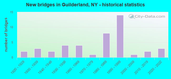
- New bridges - historical statistics
- 21920-1929
- 31930-1939
- 21940-1949
- 41950-1959
- 41960-1969
- 11970-1979
- 81980-1989
- 141990-1999
- 12000-2009
- 22010-2019
- 32020-2022
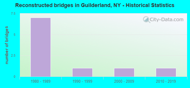
- Reconstructed bridges - Historical Statistics
- 71980-1989
- 11990-1999
- 12000-2009
- 12010-2019
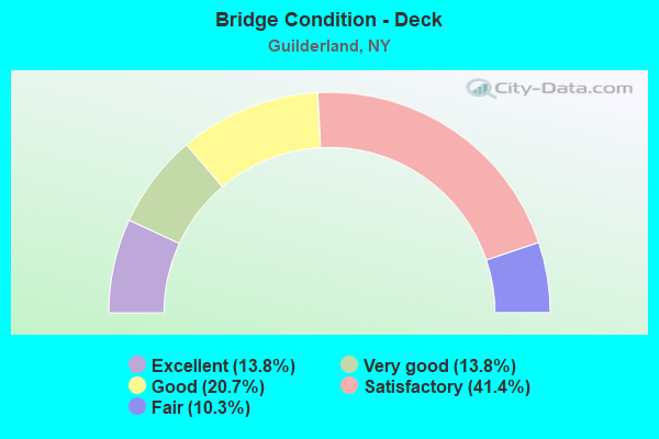
- Bridge Condition - Deck
- 13.8%Excellent
- 13.8%Very good
- 20.7%Good
- 41.4%Satisfactory
- 10.3%Fair
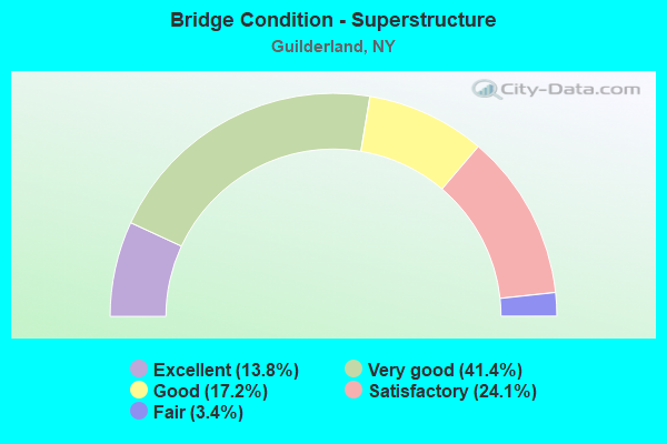
- Bridge Condition - Superstructure
- 13.8%Excellent
- 41.4%Very good
- 17.2%Good
- 24.1%Satisfactory
- 3.4%Fair
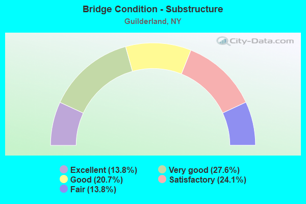
- Bridge Condition - Substructure
- 13.8%Excellent
- 27.6%Very good
- 20.7%Good
- 24.1%Satisfactory
- 13.8%Fair
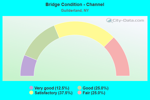
- Bridge Condition - Channel
- 12.5%Very good
- 25.0%Good
- 37.5%Satisfactory
- 25.0%Fair
Find on map >> Show street view
Structure Number: 101595, Location: .2 MI W JCT US 20 & SH158 (Lat: 42.735961, Lng: -73.988994), Route carried "on" structure: US 20, Year Built: 1941, Year Reconstructed: 1989, Status: Open, Structure Length: 1.65m (5.41ft), Average Daily Traffic: 4,755 (year 2020), Truck Traffic: 9%, Average Future Daily Traffic: 5,327 (year 2040), Features Intersected: NORMANS KILL
Minimum Vertical Clearance: 30+ m (98+ ft), Kilometerpoint: 4.280, Lanes on structure: 2, Base Highway Network: Yes, Owner: State Highway Agency, Approaching Roadway Width: 11.3m (37.1ft), Skew: 1 degrees, Material/Design: Steel, Design/Construction: Stringer/Multi-beam, Number Of Spans In Main Unit: 1, Length of Maximum Span: 15.8m (51.8ft), Curb-To-Curb Width: 11.3m (37.1ft), Out-to-Out Width: 11.9m (39.0ft)
Condition: Deck: Satisfactory, Superstructure: Satisfactory, Substructure: Satisfactory, Channel: Satisfactory, Operating Rating: 68.0 metric tons, Method Used To Determine Operating Rating: Load Factor (LF), Inventory Rating: 40.8 metric tons, Method Used To Determine Inventory Rating: Load Factor (LF), Structural Evaluation: Equal to present minimum criteria, Deck Geometry: Somewhat better than minimum adequacy, Waterway Adequacy: Somewhat better than minimum adequacy, Approach Roadway Alignment: Equal to present desirable criteria, Length Of Structure Improvement: 1.64m (5.38ft), Designated Inspection Frequency: Every 24 months, Underwater Inspection Frequency: Every 60 months, Inspection Date: May 2021, Underwater Inspection Date: May 2018, Bridge Improvement Cost: $982,000, Roadway Improvement Cost: $575,000, Total Project Cost: $1,556,000 ( Estimate for 2021), Deck Structure Type: Concrete Cast-file-Place, Wearing Surface/Protective System: Wearing Surface: Integral Concrete, Deck Protection: Epoxy Coated Reinforcing
Find on map >> Show street view
Structure Number: 101597, Location: MP 146.85 (Lat: 42.683619, Lng: -73.845603), Route carried "on" structure: US 20, Year Built: 1991, Status: Open, Structure Length: 7.01m (23.00ft), Average Daily Traffic: 35,338 (year 2017), Truck Traffic: 6%, Average Future Daily Traffic: 35,504 (year 2040), Design Load: HS 20+Mod, Features Intersected: 87IX SB, 87IX NB
Minimum Vertical Clearance: 30+ m (98+ ft), Kilometerpoint: 17.506, Lanes on structure: 6, Lanes under structure: 6, Base Highway Network: Yes, Owner: State Toll Authority, Approaching Roadway Width: 26.5m (86.9ft), Skew: 21 degrees, Material/Design: Steel continuous, Design/Construction: Stringer/Multi-beam, Number Of Spans In Main Unit: 2, Length of Maximum Span: 35.7m (117.1ft), Curb or Sidewalk Widths: Left: 1.5m (4.9ft), Right: 3.5m (11.5ft), Curb-To-Curb Width: 26.5m (86.9ft), Out-to-Out Width: 32.1m (105.3ft)
Condition: Deck: Satisfactory, Superstructure: Very good, Substructure: Good, Operating Rating: 63.5 metric tons, Method Used To Determine Operating Rating: Load Factor (LF), Inventory Rating: 32.7 metric tons, Method Used To Determine Inventory Rating: Load Factor (LF), Structural Evaluation: Better than present minimum criteria, Deck Geometry: Equal to present minimum criteria, Underclear: Somewhat better than minimum adequacy, Approach Roadway Alignment: Equal to present desirable criteria, Length Of Structure Improvement: 7.01m (23.00ft), Designated Inspection Frequency: Every 24 months, Inspection Date: April 2020, Bridge Improvement Cost: $4,984,000, Roadway Improvement Cost: $2,919,000, Total Project Cost: $7,903,000 ( Estimate for 2021), Deck Structure Type: Concrete Cast-file-Place, Wearing Surface/Protective System: Wearing Surface: Integral Concrete, Deck Protection: Epoxy Coated Reinforcing
Find on map >> Show street view
Structure Number: 1033121, Location: .8 MI S JCT I87 & 910B (Lat: 42.702397, Lng: -73.834247), Route carried "on" structure: Interstate 87, Year Built: 1957, Year Reconstructed: 1990, Status: Open, Structure Length: 5.73m (18.80ft), Average Daily Traffic: 59,744 (year 2006), Truck Traffic: 7%, Design Load: HS 20+Mod, Features Intersected: CSX TRANS/ AMTRAK
Minimum Vertical Clearance: 30+ m (98+ ft), Kilometerpoint: 31.906, Lanes on structure: 4, Base Highway Network: Yes, Owner: State Highway Agency, Approaching Roadway Width: 18.9m (62.0ft), Skew: 2 degrees, Material/Design: Steel, Design/Construction: Stringer/Multi-beam, Number Of Spans In Main Unit: 3, Length of Maximum Span: 21.6m (70.9ft), Curb-To-Curb Width: 18.8m (61.7ft), Out-to-Out Width: 19.8m (65.0ft)
Condition: Deck: Good, Superstructure: Satisfactory, Substructure: Satisfactory, Operating Rating: 54.1 metric tons, Method Used To Determine Operating Rating: Load and Resistance Factor Rating (LRFR) rating reported by rating factor(RF) method using HL-93 loadings, Inventory Rating: 41.5 metric tons, Method Used To Determine Inventory Rating: Load and Resistance Factor Rating (LRFR) rating reported by rating factor(RF) method using HL-93 loadings, Structural Evaluation: Equal to present minimum criteria, Deck Geometry: Meets minimum limits, Underclear: Somewhat better than minimum adequacy, Approach Roadway Alignment: Equal to present desirable criteria, Length Of Structure Improvement: 5.73m (18.80ft), Designated Inspection Frequency: Every 24 months, Inspection Date: September 2021, Bridge Improvement Cost: $2,466,000, Roadway Improvement Cost: $1,444,000, Total Project Cost: $3,910,000 ( Estimate for 2021), Deck Structure Type: Concrete Cast-file-Place, Wearing Surface/Protective System: Wearing Surface: Integral Concrete, Deck Protection: Epoxy Coated Reinforcing
Find on map >> Show street view
Structure Number: 1033122, Location: .8 MILE S JCT I87 & 910B (Lat: 42.702214, Lng: -73.834039), Route carried "on" structure: Interstate 87, Year Built: 1959, Year Reconstructed: 1986, Status: Open, Structure Length: 5.55m (18.21ft), Average Daily Traffic: 43,877 (year 2013), Truck Traffic: 7%, Average Future Daily Traffic: 69,532 (year 2040), Design Load: HS 20+Mod, Features Intersected: CSX TRANS/ AMTRAK
Minimum Vertical Clearance: 30+ m (98+ ft), Kilometerpoint: 31.890, Lanes on structure: 5, Base Highway Network: Yes, Owner: State Highway Agency, Approaching Roadway Width: 22.6m (74.1ft), Skew: 2 degrees, Material/Design: Steel, Design/Construction: Stringer/Multi-beam, Number Of Spans In Main Unit: 3, Length of Maximum Span: 21.6m (70.9ft), Curb-To-Curb Width: 22.4m (73.5ft), Out-to-Out Width: 23.3m (76.4ft)
Condition: Deck: Good, Superstructure: Good, Substructure: Satisfactory, Operating Rating: 73.5 metric tons, Method Used To Determine Operating Rating: Load and Resistance Factor Rating (LRFR) rating reported by rating factor(RF) method using HL-93 loadings, Inventory Rating: 56.7 metric tons, Method Used To Determine Inventory Rating: Load and Resistance Factor Rating (LRFR) rating reported by rating factor(RF) method using HL-93 loadings, Structural Evaluation: Equal to present minimum criteria, Deck Geometry: Meets minimum limits, Underclear: Somewhat better than minimum adequacy, Approach Roadway Alignment: Equal to present desirable criteria, Length Of Structure Improvement: 5.54m (18.18ft), Designated Inspection Frequency: Every 24 months, Inspection Date: September 2021, Bridge Improvement Cost: $2,769,000, Roadway Improvement Cost: $1,622,000, Total Project Cost: $4,391,000 ( Estimate for 2021), Deck Structure Type: Concrete Cast-file-Place, Wearing Surface/Protective System: Wearing Surface: Integral Concrete, Deck Protection: Epoxy Coated Reinforcing
Find on map >> Show street view
Structure Number: 103829, Location: .2 MI W JCT RTS 146 & 158 (Lat: 42.711439, Lng: -73.990083), Route carried "on" structure: State highway 146, Year Built: 1994, Status: Open, Structure Length: 1.68m (5.51ft), Average Daily Traffic: 5,102 (year 2019), Truck Traffic: 5%, Average Future Daily Traffic: 6,312 (year 2040), Design Load: HS 25 or greater, Features Intersected: BLACK CREEK
Minimum Vertical Clearance: 30+ m (98+ ft), Kilometerpoint: 15.704, Lanes on structure: 2, Base Highway Network: Yes, Owner: State Highway Agency, Approaching Roadway Width: 12.5m (41.0ft), Skew: 1 degrees, Material/Design: Prestressed concrete, Design/Construction: Box Beam or Girders - Multiple, Number Of Spans In Main Unit: 1, Length of Maximum Span: 16.4m (53.8ft), Curb-To-Curb Width: 12.3m (40.4ft), Out-to-Out Width: 13.0m (42.7ft)
Condition: Deck: Satisfactory, Superstructure: Very good, Substructure: Very good, Channel: Very good, Operating Rating: 70.8 metric tons, Method Used To Determine Operating Rating: Load Factor (LF), Inventory Rating: 42.6 metric tons, Method Used To Determine Inventory Rating: Load Factor (LF), Structural Evaluation: Equal to present desirable criteria, Deck Geometry: Somewhat better than minimum adequacy, Waterway Adequacy: Equal to present minimum criteria, Approach Roadway Alignment: Equal to present desirable criteria, Length Of Structure Improvement: 1.67m (5.48ft), Designated Inspection Frequency: Every 24 months, Inspection Date: July 2020, Bridge Improvement Cost: $929,000, Roadway Improvement Cost: $544,000, Total Project Cost: $1,472,000 ( Estimate for 2021), Deck Structure Type: Concrete Cast-file-Place, Wearing Surface/Protective System: Wearing Surface: Monolithic Concrete, Deck Protection: Epoxy Coated Reinforcing
Find on map >> Show street view
Structure Number: 10383, Location: 1.8 MI E JCT SH146 &SH158 (Lat: 42.702731, Lng: -73.957889), Route carried "on" structure: State highway 146, Year Built: 1985, Status: Open, Structure Length: 7.19m (23.59ft), Average Daily Traffic: 9,993 (year 2020), Truck Traffic: 11%, Average Future Daily Traffic: 12,139 (year 2040), Design Load: HS 20, Features Intersected: ACCESS ROAD, CSX TRANSPR
Minimum Vertical Clearance: 30+ m (98+ ft), Kilometerpoint: 18.600, Lanes on structure: 2, Lanes under structure: 1, Base Highway Network: Yes, Owner: State Highway Agency, Approaching Roadway Width: 12.2m (40.0ft), Material/Design: Prestressed concrete, Design/Construction: Box Beam or Girders - Multiple, Number Of Spans In Main Unit: 4, Length of Maximum Span: 24.9m (81.7ft), Curb-To-Curb Width: 12.1m (39.7ft), Out-to-Out Width: 13.7m (44.9ft)
Condition: Deck: Fair, Superstructure: Satisfactory, Substructure: Good, Operating Rating: 62.6 metric tons, Method Used To Determine Operating Rating: Load Factor (LF), Inventory Rating: 37.2 metric tons, Method Used To Determine Inventory Rating: Load Factor (LF), Structural Evaluation: Equal to present minimum criteria, Deck Geometry: Somewhat better than minimum adequacy, Underclear: Meets minimum limits, Approach Roadway Alignment: Equal to present desirable criteria, Length Of Structure Improvement: 7.19m (23.59ft), Designated Inspection Frequency: Every 24 months, Inspection Date: October 2021, Bridge Improvement Cost: $2,740,000, Roadway Improvement Cost: $1,604,000, Total Project Cost: $4,344,000 ( Estimate for 2021), Deck Structure Type: Concrete Cast-file-Place, Wearing Surface/Protective System: Wearing Surface: Monolithic Concrete, Deck Protection: Epoxy Coated Reinforcing
Find on map >> Show street view
Structure Number: 103831, Location: 2.9 MI E JCT RT 146 & 158 (Lat: 42.703072, Lng: -73.937575), Route carried "on" structure: State highway 146, Year Built: 1930, Year Reconstructed: 1986, Status: Open, Structure Length: 4.75m (15.58ft), Average Daily Traffic: 9,993 (year 2020), Truck Traffic: 11%, Average Future Daily Traffic: 12,139 (year 2040), Design Load: HS 20, Features Intersected: NORMANS KILL
Minimum Vertical Clearance: 30+ m (98+ ft), Kilometerpoint: 20.289, Lanes on structure: 2, Base Highway Network: Yes, Owner: State Highway Agency, Approaching Roadway Width: 11.0m (36.1ft), Material/Design: Steel, Design/Construction: Girder and Floorbeam System, Number Of Spans In Main Unit: 3, Length of Maximum Span: 21.3m (69.9ft), Curb-To-Curb Width: 11.0m (36.1ft), Out-to-Out Width: 11.6m (38.1ft)
Condition: Deck: Satisfactory, Superstructure: Satisfactory, Substructure: Satisfactory, Channel: Satisfactory, Operating Rating: 56.2 metric tons, Method Used To Determine Operating Rating: Load Factor (LF), Inventory Rating: 33.6 metric tons, Method Used To Determine Inventory Rating: Load Factor (LF), Structural Evaluation: Equal to present minimum criteria, Deck Geometry: Meets minimum limits, Waterway Adequacy: Equal to present desirable criteria, Approach Roadway Alignment: Equal to present desirable criteria, Length Of Structure Improvement: 4.75m (15.58ft), Designated Inspection Frequency: Every 24 months, Critical Feature Inspection Frequency: Every 12 months, Inspection Date: May 2021, Critical Feature Inspection Date: May 2021, Bridge Improvement Cost: $1,375,000, Roadway Improvement Cost: $805,000, Total Project Cost: $2,180,000 ( Estimate for 2021), Deck Structure Type: Concrete Cast-file-Place, Wearing Surface/Protective System: Wearing Surface: Integral Concrete, Deck Protection: Epoxy Coated Reinforcing
Find on map >> Show street view
Structure Number: 103832, Location: 0.6 MI SW JCT RTS 7 & 146 (Lat: 42.758636, Lng: -73.943186), Route carried "on" structure: State highway 146, Year Built: 1993, Status: Open, Structure Length: 5.67m (18.60ft), Average Daily Traffic: 10,336 (year 2020), Truck Traffic: 5%, Average Future Daily Traffic: 10,384 (year 2040), Design Load: HS 25 or greater, Features Intersected: 90IX EB, RTE I90
Minimum Vertical Clearance: 30+ m (98+ ft), Kilometerpoint: 27.868, Lanes on structure: 2, Lanes under structure: 9, Base Highway Network: Yes, Owner: State Toll Authority, Approaching Roadway Width: 18.6m (61.0ft), Skew: 21 degrees, Material/Design: Steel continuous, Design/Construction: Stringer/Multi-beam, Number Of Spans In Main Unit: 2, Length of Maximum Span: 28.0m (91.9ft), Curb or Sidewalk Widths: Left: 1.5m (4.9ft), Right: 1.5m (4.9ft), Curb-To-Curb Width: 13.4m (44.0ft), Out-to-Out Width: 17.1m (56.1ft)
Condition: Deck: Satisfactory, Superstructure: Excellent, Substructure: Good, Operating Rating: 87.1 metric tons, Method Used To Determine Operating Rating: Load Factor (LF), Inventory Rating: 46.3 metric tons, Method Used To Determine Inventory Rating: Load Factor (LF), Structural Evaluation: Better than present minimum criteria, Deck Geometry: Equal to present minimum criteria, Underclear: Meets minimum limits, Approach Roadway Alignment: Equal to present desirable criteria, Length Of Structure Improvement: 5.66m (18.57ft), Designated Inspection Frequency: Every 24 months, Inspection Date: September 2021, Bridge Improvement Cost: $2,135,000, Roadway Improvement Cost: $1,250,000, Total Project Cost: $3,385,000 ( Estimate for 2021), Deck Structure Type: Concrete Cast-file-Place, Wearing Surface/Protective System: Wearing Surface: Integral Concrete, Deck Protection: Epoxy Coated Reinforcing
Find on map >> Show street view
Structure Number: 103863, Location: 2.3 M N JCT RT 85A & 155 (Lat: 42.678761, Lng: -73.906225), Route carried "on" structure: State highway 155, Year Built: 1998, Status: Open, Structure Length: 4.82m (15.81ft), Average Daily Traffic: 7,815 (year 2018), Truck Traffic: 5%, Average Future Daily Traffic: 9,493 (year 2040), Design Load: HS 25 or greater, Features Intersected: NORMANSKILL
Minimum Vertical Clearance: 30+ m (98+ ft), Kilometerpoint: 3.588, Lanes on structure: 2, Base Highway Network: Yes, Owner: State Highway Agency, Approaching Roadway Width: 9.8m (32.2ft), Material/Design: Steel, Design/Construction: Stringer/Multi-beam, Number Of Spans In Main Unit: 1, Length of Maximum Span: 46.9m (153.9ft), Curb-To-Curb Width: 9.8m (32.2ft), Out-to-Out Width: 10.4m (34.1ft)
Condition: Deck: Very good, Superstructure: Very good, Substructure: Very good, Channel: Satisfactory, Operating Rating: 88.9 metric tons, Method Used To Determine Operating Rating: Load Factor (LF), Inventory Rating: 52.6 metric tons, Method Used To Determine Inventory Rating: Load Factor (LF), Structural Evaluation: Equal to present desirable criteria, Deck Geometry: Meets minimum limits, Waterway Adequacy: Meets minimum limits, Approach Roadway Alignment: Equal to present desirable criteria, Length Of Structure Improvement: 4.81m (15.78ft), Designated Inspection Frequency: Every 24 months, Inspection Date: March 2020, Bridge Improvement Cost: $1,230,000, Roadway Improvement Cost: $720,000, Total Project Cost: $1,950,000 ( Estimate for 2021), Deck Structure Type: Concrete Cast-file-Place, Wearing Surface/Protective System: Wearing Surface: Integral Concrete, Deck Protection: Epoxy Coated Reinforcing
Find on map >> Show street view
Structure Number: 103868, Location: .9 MI N JCT SH146 & SH158 (Lat: 42.722728, Lng: -73.992242), Route carried "on" structure: State highway 158, Year Built: 1939, Year Reconstructed: 1989, Status: Open, Structure Length: 4.30m (14.11ft), Average Daily Traffic: 4,213 (year 2016), Truck Traffic: 7%, Average Future Daily Traffic: 5,212 (year 2040), Design Load: HS 20, Features Intersected: BOZEN KILL
Minimum Vertical Clearance: 30+ m (98+ ft), Kilometerpoint: 3.652, Lanes on structure: 2, Base Highway Network: Yes, Owner: State Highway Agency, Approaching Roadway Width: 9.8m (32.2ft), Skew: 4 degrees, Material/Design: Steel, Design/Construction: Stringer/Multi-beam, Number Of Spans In Main Unit: 2, Length of Maximum Span: 21.3m (69.9ft), Curb-To-Curb Width: 9.8m (32.2ft), Out-to-Out Width: 10.4m (34.1ft)
Condition: Deck: Satisfactory, Superstructure: Satisfactory, Substructure: Fair, Channel: Satisfactory, Operating Rating: 67.7 metric tons, Method Used To Determine Operating Rating: Load and Resistance Factor Rating (LRFR) rating reported by rating factor(RF) method using HL-93 loadings, Inventory Rating: 52.2 metric tons, Method Used To Determine Inventory Rating: Load and Resistance Factor Rating (LRFR) rating reported by rating factor(RF) method using HL-93 loadings, Structural Evaluation: Somewhat better than minimum adequacy, Deck Geometry: Meets minimum limits, Waterway Adequacy: Somewhat better than minimum adequacy, Approach Roadway Alignment: Equal to present desirable criteria, Length Of Structure Improvement: 4.29m (14.07ft), Designated Inspection Frequency: Every 24 months, Inspection Date: April 2021, Bridge Improvement Cost: $1,294,000, Roadway Improvement Cost: $757,000, Total Project Cost: $2,051,000 ( Estimate for 2021), Deck Structure Type: Concrete Cast-file-Place, Wearing Surface/Protective System: Wearing Surface: Integral Concrete, Deck Protection: Epoxy Coated Reinforcing
Find on map >> Show street view
Structure Number: 103869, Location: 0.2 MI S JCT RTS 20 & 582 (Lat: 42.731944, Lng: -73.987056), Route carried "on" structure: State highway 158, Year Built: 1992, Status: Open, Structure Length: 5.43m (17.81ft), Average Daily Traffic: 4,008 (year 2018), Truck Traffic: 7%, Average Future Daily Traffic: 4,959 (year 2040), Design Load: HS 20, Features Intersected: WATERVLIET RESVOR
Minimum Vertical Clearance: 30+ m (98+ ft), Kilometerpoint: 2.494, Lanes on structure: 2, Base Highway Network: Yes, Owner: State Highway Agency, Approaching Roadway Width: 10.4m (34.1ft), Material/Design: Steel, Design/Construction: Stringer/Multi-beam, Number Of Spans In Main Unit: 1, Length of Maximum Span: 53.0m (173.9ft), Curb-To-Curb Width: 10.4m (34.1ft), Out-to-Out Width: 11.0m (36.1ft)
Condition: Deck: Good, Superstructure: Very good, Substructure: Very good, Channel: Good, Operating Rating: 86.2 metric tons, Method Used To Determine Operating Rating: Load Factor (LF), Inventory Rating: 42.6 metric tons, Method Used To Determine Inventory Rating: Load Factor (LF), Structural Evaluation: Equal to present desirable criteria, Deck Geometry: Somewhat better than minimum adequacy, Waterway Adequacy: Equal to present desirable criteria, Approach Roadway Alignment: Equal to present desirable criteria, Length Of Structure Improvement: 5.42m (17.78ft), Designated Inspection Frequency: Every 24 months, Inspection Date: April 2021, Bridge Improvement Cost: $1,379,000, Roadway Improvement Cost: $808,000, Total Project Cost: $2,186,000 ( Estimate for 2021), Deck Structure Type: Concrete Cast-file-Place, Wearing Surface/Protective System: Wearing Surface: Integral Concrete, Deck Protection: Epoxy Coated Reinforcing
Find on map >> Show street view
Structure Number: 104752, Location: 2.3 MI S JCT RTS 20 & 397 (Lat: 42.714308, Lng: -74.029231), Route carried "on" structure: State highway 397, Year Built: 2002, Status: Open, Structure Length: 2.10m (6.89ft), Average Daily Traffic: 1,776 (year 2020), Truck Traffic: 6%, Average Future Daily Traffic: 2,486 (year 2040), Design Load: HS 25 or greater, Features Intersected: BOZEN KILL
Minimum Vertical Clearance: 30+ m (98+ ft), Kilometerpoint: 3.701, Lanes on structure: 2, Base Highway Network: Yes, Owner: State Highway Agency, Approaching Roadway Width: 9.4m (30.8ft), Skew: 1 degrees, Material/Design: Prestressed concrete, Design/Construction: Box Beam or Girders - Multiple, Number Of Spans In Main Unit: 1, Length of Maximum Span: 20.0m (65.6ft), Curb-To-Curb Width: 9.5m (31.2ft), Out-to-Out Width: 10.5m (34.4ft)
Condition: Deck: Satisfactory, Superstructure: Good, Substructure: Very good, Channel: Fair, Operating Rating: 73.5 metric tons, Method Used To Determine Operating Rating: Load Factor (LF), Inventory Rating: 44.5 metric tons, Method Used To Determine Inventory Rating: Load Factor (LF), Structural Evaluation: Better than present minimum criteria, Deck Geometry: Somewhat better than minimum adequacy, Waterway Adequacy: Equal to present minimum criteria, Approach Roadway Alignment: Equal to present desirable criteria, Length Of Structure Improvement: 2.10m (6.89ft), Designated Inspection Frequency: Every 24 months, Inspection Date: May 2020, Bridge Improvement Cost: $1,042,000, Roadway Improvement Cost: $610,000, Total Project Cost: $1,651,000 ( Estimate for 2021), Deck Structure Type: Concrete Cast-file-Place, Wearing Surface/Protective System: Wearing Surface: Monolithic Concrete, Deck Protection: Epoxy Coated Reinforcing
Find on map >> Show street view
Structure Number: 1050049, Location: I87 RAMP TO I90 (Lat: 42.690392, Lng: -73.844117), Route carried "on" structure: City street 910D, Year Built: 1969, Status: Open, Structure Length: 5.58m (18.31ft), Average Daily Traffic: 18,944 (year 2020), Truck Traffic: 5%, Average Future Daily Traffic: 21,952 (year 2040), Design Load: HS 20, Features Intersected: 90IX SB, 90IX NB
Minimum Vertical Clearance: 30+ m (98+ ft), Kilometerpoint: 3.475, Lanes on structure: 4, Lanes under structure: 6, Base Highway Network: Yes, Owner: State Highway Agency, Approaching Roadway Width: 23.5m (77.1ft), Skew: 30 degrees, Material/Design: Steel, Design/Construction: Stringer/Multi-beam, Number Of Spans In Main Unit: 2, Length of Maximum Span: 27.4m (89.9ft), Curb-To-Curb Width: 19.6m (64.3ft), Out-to-Out Width: 21.5m (70.5ft)
Condition: Deck: Satisfactory, Superstructure: Satisfactory, Substructure: Fair, Operating Rating: 75.3 metric tons, Method Used To Determine Operating Rating: Load Factor (LF), Inventory Rating: 45.4 metric tons, Method Used To Determine Inventory Rating: Load Factor (LF), Structural Evaluation: Somewhat better than minimum adequacy, Deck Geometry: Somewhat better than minimum adequacy, Underclear: Meets minimum limits, Approach Roadway Alignment: Equal to present desirable criteria, Length Of Structure Improvement: 5.57m (18.27ft), Designated Inspection Frequency: Every 24 months, Inspection Date: September 2020, Bridge Improvement Cost: $3,017,000, Roadway Improvement Cost: $1,767,000, Total Project Cost: $4,784,000 ( Estimate for 2021), Deck Structure Type: Concrete Cast-file-Place, Wearing Surface/Protective System: Wearing Surface: Bituminous
Find on map >> Show street view
Structure Number: 107312, Location: JCT. RTE US 20 + 87I (Lat: 42.683200, Lng: -73.844219), Route carried "on" structure: Ramp Other road , Year Built: 1984, Status: Open, Structure Length: 2.93m (9.61ft), Average Daily Traffic: 7,621 (year 2018), Truck Traffic: 6%, Average Future Daily Traffic: 8,831 (year 2040), Design Load: HS 20, Features Intersected: US20 EB to 910F NB, RTE, Facility Carried by Structure: US20 EB to910F NB
Minimum Vertical Clearance: 30+ m (98+ ft), Kilometerpoint: 0.756, Lanes on structure: 1, Lanes under structure: 5, Owner: State Highway Agency, Approaching Roadway Width: 6.4m (21.0ft), Material/Design: Steel, Design/Construction: Stringer/Multi-beam, Number Of Spans In Main Unit: 1, Length of Maximum Span: 28.6m (93.8ft), Curb-To-Curb Width: 6.4m (21.0ft), Out-to-Out Width: 7.3m (24.0ft)
Condition: Deck: Satisfactory, Superstructure: Very good, Substructure: Fair, Operating Rating: 76.1 metric tons, Method Used To Determine Operating Rating: Load and Resistance Factor Rating (LRFR) rating reported by rating factor(RF) method using HL-93 loadings, Inventory Rating: 58.6 metric tons, Method Used To Determine Inventory Rating: Load and Resistance Factor Rating (LRFR) rating reported by rating factor(RF) method using HL-93 loadings, Structural Evaluation: Somewhat better than minimum adequacy, Deck Geometry: Somewhat better than minimum adequacy, Underclear: High priority of corrective action, Approach Roadway Alignment: Equal to present desirable criteria, Length Of Structure Improvement: 2.92m (9.58ft), Designated Inspection Frequency: Every 24 months, Inspection Date: April 2020, Bridge Improvement Cost: $744,000, Roadway Improvement Cost: $436,000, Total Project Cost: $1,179,000 ( Estimate for 2021), Deck Structure Type: Concrete Cast-file-Place, Wearing Surface/Protective System: Wearing Surface: Integral Concrete, Deck Protection: Epoxy Coated Reinforcing
Find on map >> Show street view
Structure Number: 107313, Location: 0.4MI N.JCT.RTE20 +90I (Lat: 42.687419, Lng: -73.844769), Route carried "on" structure: Ramp Other road , Year Built: 1984, Status: Open, Structure Length: 5.24m (17.19ft), Truck Traffic: 10%, Design Load: HS 20, Features Intersected: THRUWAY I-87, THRUWAY I-, Facility Carried by Structure: CROSSGATES ROAD
Minimum Vertical Clearance: 30+ m (98+ ft), Kilometerpoint: 0.290, Lanes on structure: 1, Lanes under structure: 6, Owner: State Highway Agency, Approaching Roadway Width: 7.0m (23.0ft), Skew: 1 degrees, Material/Design: Steel, Design/Construction: Stringer/Multi-beam, Number Of Spans In Main Unit: 2, Length of Maximum Span: 25.9m (85.0ft), Curb-To-Curb Width: 6.7m (22.0ft), Out-to-Out Width: 7.6m (24.9ft)
Condition: Deck: Satisfactory, Superstructure: Good, Substructure: Satisfactory, Operating Rating: 76.2 metric tons, Method Used To Determine Operating Rating: Load Factor (LF), Inventory Rating: 37.2 metric tons, Method Used To Determine Inventory Rating: Load Factor (LF), Structural Evaluation: Equal to present minimum criteria, Deck Geometry: Equal to present minimum criteria, Underclear: Meets minimum limits, Approach Roadway Alignment: High priority of corrective action, Length Of Structure Improvement: 5.24m (17.19ft), Designated Inspection Frequency: Every 24 months, Inspection Date: October 2020, Bridge Improvement Cost: $1,185,000, Roadway Improvement Cost: $694,000, Total Project Cost: $1,878,000 ( Estimate for 2021), Deck Structure Type: Concrete Cast-file-Place, Wearing Surface/Protective System: Wearing Surface: Integral Concrete, Deck Protection: Epoxy Coated Reinforcing
Find on map >> Show street view
Structure Number: 1073149, Location: 0.1W.JCT 87ITWASH.AV.EXT. (Lat: 42.690650, Lng: -73.845444), Route carried "on" structure: City street 910D, Year Built: 1984, Status: Open, Structure Length: 1.74m (5.71ft), Average Daily Traffic: 18,944 (year 2020), Truck Traffic: 5%, Average Future Daily Traffic: 21,952 (year 2040), Design Load: HS 20, Features Intersected: CROSSGATE MALL ACCESS RA
Minimum Vertical Clearance: 30+ m (98+ ft), Kilometerpoint: 3.379, Lanes on structure: 4, Lanes under structure: 2, Base Highway Network: Yes, Owner: State Highway Agency, Approaching Roadway Width: 24.7m (81.0ft), Skew: 30 degrees, Material/Design: Steel, Design/Construction: Stringer/Multi-beam, Number Of Spans In Main Unit: 1, Length of Maximum Span: 16.7m (54.8ft), Curb-To-Curb Width: 24.5m (80.4ft), Out-to-Out Width: 27.9m (91.5ft)
Condition: Deck: Satisfactory, Superstructure: Very good, Substructure: Very good, Operating Rating: 69.9 metric tons, Method Used To Determine Operating Rating: Load Factor (LF), Inventory Rating: 42.6 metric tons, Method Used To Determine Inventory Rating: Load Factor (LF), Structural Evaluation: Equal to present desirable criteria, Deck Geometry: Superior to present desirable criteria, Underclear: Meets minimum limits, Approach Roadway Alignment: Equal to present desirable criteria, Length Of Structure Improvement: 1.73m (5.68ft), Designated Inspection Frequency: Every 24 months, Inspection Date: May 2020, Bridge Improvement Cost: $2,619,000, Roadway Improvement Cost: $1,533,000, Total Project Cost: $4,152,000 ( Estimate for 2021), Deck Structure Type: Concrete Cast-file-Place, Wearing Surface/Protective System: Wearing Surface: Bituminous, Deck Protection: Epoxy Coated Reinforcing
Find on map >> Show street view
Structure Number: 107983, Location: 0.4mi W INT GRANT HILL RD (Lat: 42.689572, Lng: -73.927861), Route carried "on" structure: ServiceOther road , Year Built: 2016, Status: Open, Structure Length: 4.82m (15.81ft), Average Daily Traffic: 50 (year 2015), Truck Traffic: 5%, Average Future Daily Traffic: 70 (year 2035), Design Load: HS 20, Features Intersected: Normans Kill, Facility Carried by Structure: Rifle Range Access
Minimum Vertical Clearance: 32.69m (107.25ft), Kilometerpoint: 0.000, Lanes on structure: 1, Owner: State Agenciy, Approaching Roadway Width: 6.1m (20.0ft), Material/Design: Steel, Design/Construction: Truss - Thru, Number Of Spans In Main Unit: 1, Length of Maximum Span: 47.2m (154.9ft), Curb or Sidewalk Widths: Left: 0.0m, Right: 1.8m (5.9ft), Curb-To-Curb Width: 5.2m (17.1ft), Out-to-Out Width: 7.3m (24.0ft)
Condition: Deck: Very good, Superstructure: Good, Substructure: Very good, Channel: Satisfactory, Inventory Rating: 32.7 metric tons, Method Used To Determine Inventory Rating: Field evaluation and documented engineering judgment, Structural Evaluation: Better than present minimum criteria, Deck Geometry: High priority of corrective action, Waterway Adequacy: Equal to present desirable criteria, Approach Roadway Alignment: High priority of corrective action, Length Of Structure Improvement: 4.81m (15.78ft), Designated Inspection Frequency: Every 24 months, Critical Feature Inspection Frequency: Every 24 months, Inspection Date: July 2020, Critical Feature Inspection Date: July 2020, Bridge Improvement Cost: $2,306,000, Roadway Improvement Cost: $1,351,000, Total Project Cost: $3,657,000 ( Estimate for 2021), Deck Structure Type: Steel plate, Wearing Surface/Protective System: Wearing Surface: Other
Find on map >> Show street view
Structure Number: 330115, Location: 1.2 MI S OF GUILDERLAND (Lat: 42.690933, Lng: -73.920492), Route carried "on" structure: Other road , Year Built: 2014, Status: Open, Structure Length: 4.69m (15.39ft), Average Daily Traffic: 236 (year 2018), Truck Traffic: 3%, Average Future Daily Traffic: 330 (year 2038), Features Intersected: NORMANS KILL, Facility Carried by Structure: GRANT HILL ROAD
Minimum Vertical Clearance: 30+ m (98+ ft), Kilometerpoint: 2.542, Lanes on structure: 2, Owner: County Highway Agency, Approaching Roadway Width: 7.9m (25.9ft), Material/Design: Steel, Design/Construction: Truss - Thru, Number Of Spans In Main Unit: 1, Length of Maximum Span: 44.5m (146.0ft), Curb-To-Curb Width: 7.9m (25.9ft), Out-to-Out Width: 9.1m (29.9ft)
Condition: Deck: Very good, Superstructure: Very good, Substructure: Excellent, Channel: Good, Operating Rating: 38.2 metric tons, Method Used To Determine Operating Rating: Load and Resistance Factor Rating (LRFR) rating reported by rating factor(RF) method using HL-93 loadings, Inventory Rating: 29.5 metric tons, Method Used To Determine Inventory Rating: Load and Resistance Factor Rating (LRFR) rating reported by rating factor(RF) method using HL-93 loadings, Structural Evaluation: Better than present minimum criteria, Deck Geometry: Somewhat better than minimum adequacy, Waterway Adequacy: Equal to present minimum criteria, Approach Roadway Alignment: Equal to present minimum criteria, Length Of Structure Improvement: 4.69m (15.39ft), Designated Inspection Frequency: Every 24 months, Critical Feature Inspection Frequency: Every 24 months, Inspection Date: September 2020, Critical Feature Inspection Date: September 2020, Bridge Improvement Cost: $3,563,000, Roadway Improvement Cost: $2,086,000, Total Project Cost: $5,649,000 ( Estimate for 2021), Deck Structure Type: Concrete Cast-file-Place, Wearing Surface/Protective System: Wearing Surface: Monolithic Concrete, Deck Protection: Epoxy Coated Reinforcing
Find on map >> Show street view
Structure Number: 330116, Location: 1.2 MI NW OF VOORHEESVLLE (Lat: 42.676475, Lng: -73.952256), Route carried "on" structure: County highway , Year Built: 1933, Year Reconstructed: 1992, Status: Open, Structure Length: 0.82m (2.69ft), Average Daily Traffic: 1,999 (year 2019), Truck Traffic: 7%, Average Future Daily Traffic: 2,473 (year 2040), Design Load: HS 25 or greater, Features Intersected: BLACK CREEK, Facility Carried by Structure: COUNTY ROAD 201
Minimum Vertical Clearance: 30+ m (98+ ft), Kilometerpoint: 3.717, Lanes on structure: 2, Owner: County Highway Agency, Approaching Roadway Width: 9.1m (29.9ft), Material/Design: Concrete, Design/Construction: Slab, Number Of Spans In Main Unit: 1, Length of Maximum Span: 7.9m (25.9ft), Curb-To-Curb Width: 9.1m (29.9ft), Out-to-Out Width: 9.8m (32.2ft)
Condition: Deck: Good, Superstructure: Satisfactory, Substructure: Fair, Channel: Fair, Inventory Rating: 75.3 metric tons, Method Used To Determine Inventory Rating: Load Factor (LF), Structural Evaluation: Somewhat better than minimum adequacy, Deck Geometry: Somewhat better than minimum adequacy, Waterway Adequacy: Somewhat better than minimum adequacy, Approach Roadway Alignment: Equal to present desirable criteria, Length Of Structure Improvement: 0.85m (2.79ft), Designated Inspection Frequency: Every 24 months, Inspection Date: July 2021, Bridge Improvement Cost: $406,000, Roadway Improvement Cost: $238,000, Total Project Cost: $644,000 ( Estimate for 2021), Deck Structure Type: Concrete Cast-file-Place, Wearing Surface/Protective System: Wearing Surface: Integral Concrete, Deck Protection: Epoxy Coated Reinforcing
Find on map >> Show street view
Structure Number: 330117, Location: IN GUILDERLAND CENTER (Lat: 42.702042, Lng: -73.966150), Route carried "on" structure: County highway , Year Built: 2021, Status: Open, Structure Length: 1.11m (3.64ft), Average Daily Traffic: 3,584 (year 2019), Truck Traffic: 10%, Average Future Daily Traffic: 4,434 (year 2040), Design Load: HL 93, Features Intersected: BLACK CREEK, Facility Carried by Structure: SCHOOL ROAD
Minimum Vertical Clearance: 30+ m (98+ ft), Kilometerpoint: 6.034, Lanes on structure: 2, Owner: County Highway Agency, Approaching Roadway Width: 8.4m (27.6ft), Material/Design: Steel, Design/Construction: Stringer/Multi-beam, Number Of Spans In Main Unit: 1, Length of Maximum Span: 10.2m (33.5ft), Curb or Sidewalk Widths: Left: 1.4m (4.6ft), Right: 1.6m (5.2ft), Curb-To-Curb Width: 8.5m (27.9ft), Out-to-Out Width: 12.6m (41.3ft)
Condition: Deck: Excellent, Superstructure: Excellent, Substructure: Good, Channel: Good, Operating Rating: 78.7 metric tons, Method Used To Determine Operating Rating: Load and Resistance Factor Rating (LRFR) rating reported by rating factor(RF) method using HL-93 loadings, Inventory Rating: 60.6 metric tons, Method Used To Determine Inventory Rating: Load and Resistance Factor Rating (LRFR) rating reported by rating factor(RF) method using HL-93 loadings, Structural Evaluation: Better than present minimum criteria, Deck Geometry: Meets minimum limits, Waterway Adequacy: Equal to present minimum criteria, Approach Roadway Alignment: Equal to present desirable criteria, Length Of Structure Improvement: 1.03m (3.38ft), Designated Inspection Frequency: Every 24 months, Inspection Date: April 2021, Bridge Improvement Cost: $628,000, Roadway Improvement Cost: $368,000, Total Project Cost: $996,000 ( Estimate for 2021), Deck Structure Type: Concrete Cast-file-Place, Wearing Surface/Protective System: Wearing Surface: Integral Concrete, Deck Protection: Epoxy Coated Reinforcing
Find on map >> Show street view
Structure Number: 330118, Location: 1.5 MI NW OF ALTAMONT (Lat: 42.713828, Lng: -74.045764), Route carried "on" structure: Other road , Year Built: 1999, Status: Open, Structure Length: 2.19m (7.19ft), Average Daily Traffic: 193 (year 2020), Truck Traffic: 6%, Average Future Daily Traffic: 270 (year 2040), Design Load: HS 25 or greater, Features Intersected: BOZENKILL, Facility Carried by Structure: WESTFALL ROAD
Minimum Vertical Clearance: 30+ m (98+ ft), Kilometerpoint: 0.177, Lanes on structure: 2, Owner: County Highway Agency, Approaching Roadway Width: 8.5m (27.9ft), Material/Design: Steel, Design/Construction: Stringer/Multi-beam, Number Of Spans In Main Unit: 1, Length of Maximum Span: 21.3m (69.9ft), Curb-To-Curb Width: 8.5m (27.9ft), Out-to-Out Width: 9.1m (29.9ft)
Condition: Deck: Satisfactory, Superstructure: Very good, Substructure: Good, Channel: Fair, Operating Rating: 81.6 metric tons, Method Used To Determine Operating Rating: Load Factor (LF), Inventory Rating: 49.0 metric tons, Method Used To Determine Inventory Rating: Load Factor (LF), Structural Evaluation: Better than present minimum criteria, Deck Geometry: Equal to present minimum criteria, Waterway Adequacy: Superior to present desirable criteria, Approach Roadway Alignment: Equal to present minimum criteria, Length Of Structure Improvement: 2.19m (7.19ft), Designated Inspection Frequency: Every 24 months, Inspection Date: May 2020, Bridge Improvement Cost: $670,000, Roadway Improvement Cost: $392,000, Total Project Cost: $1,063,000 ( Estimate for 2021), Deck Structure Type: Concrete Cast-file-Place, Wearing Surface/Protective System: Wearing Surface: Bituminous, Deck Protection: Epoxy Coated Reinforcing
Find on map >> Show street view
Structure Number: 330119, Location: 1.3 MI NE OF DUNNSVILLE (Lat: 42.746064, Lng: -73.995083), Route carried "on" structure: Other road , Year Built: 1963, Year Reconstructed: 1992, Status: Open, Structure Length: 2.19m (7.19ft), Average Daily Traffic: 245 (year 2016), Truck Traffic: 9%, Average Future Daily Traffic: 343 (year 2036), Design Load: HS 20, Features Intersected: NORMANS KILL, Facility Carried by Structure: W. OLD STATE ROAD
Minimum Vertical Clearance: 30+ m (98+ ft), Kilometerpoint: 1.770, Lanes on structure: 2, Owner: County Highway Agency, Approaching Roadway Width: 9.1m (29.9ft), Material/Design: Steel, Design/Construction: Stringer/Multi-beam, Number Of Spans In Main Unit: 1, Length of Maximum Span: 21.0m (68.9ft), Curb-To-Curb Width: 9.2m (30.2ft), Out-to-Out Width: 9.8m (32.2ft)
Condition: Deck: Good, Superstructure: Very good, Substructure: Good, Channel: Fair, Operating Rating: 79.8 metric tons, Method Used To Determine Operating Rating: Allowable Stress (AS), Inventory Rating: 46.3 metric tons, Method Used To Determine Inventory Rating: Allowable Stress (AS), Structural Evaluation: Better than present minimum criteria, Deck Geometry: Equal to present minimum criteria, Waterway Adequacy: Meets minimum limits, Approach Roadway Alignment: Equal to present desirable criteria, Length Of Structure Improvement: 2.19m (7.19ft), Designated Inspection Frequency: Every 24 months, Inspection Date: May 2021, Bridge Improvement Cost: $800,000, Roadway Improvement Cost: $468,000, Total Project Cost: $1,268,000 ( Estimate for 2021), Deck Structure Type: Concrete Cast-file-Place, Wearing Surface/Protective System: Wearing Surface: Integral Concrete, Deck Protection: Epoxy Coated Reinforcing
Find on map >> Show street view
Structure Number: 33012, Location: 2.5MI NW OF VOORHEESVILLE (Lat: 42.705358, Lng: -73.976167), Route carried "on" structure: County highway , Year Built: 1943, Year Reconstructed: 1991, Status: Open, Structure Length: 1.16m (3.81ft), Average Daily Traffic: 1,701 (year 2019), Truck Traffic: 7%, Average Future Daily Traffic: 2,104 (year 2040), Design Load: HS 25 or greater, Features Intersected: BLACK CREEK, Facility Carried by Structure: CR 201
Minimum Vertical Clearance: 30+ m (98+ ft), Kilometerpoint: 8.222, Lanes on structure: 2, Owner: County Highway Agency, Approaching Roadway Width: 9.1m (29.9ft), Material/Design: Steel, Design/Construction: Stringer/Multi-beam, Number Of Spans In Main Unit: 1, Length of Maximum Span: 10.6m (34.8ft), Curb-To-Curb Width: 9.1m (29.9ft), Out-to-Out Width: 9.8m (32.2ft)
Condition: Deck: Fair, Superstructure: Good, Substructure: Satisfactory, Channel: Very good, Operating Rating: 74.4 metric tons, Method Used To Determine Operating Rating: Load Factor (LF), Inventory Rating: 47.2 metric tons, Method Used To Determine Inventory Rating: Load Factor (LF), Structural Evaluation: Equal to present minimum criteria, Deck Geometry: Somewhat better than minimum adequacy, Waterway Adequacy: Equal to present minimum criteria, Approach Roadway Alignment: Equal to present desirable criteria, Length Of Structure Improvement: 1.15m (3.77ft), Designated Inspection Frequency: Every 24 months, Inspection Date: August 2020, Bridge Improvement Cost: $397,000, Roadway Improvement Cost: $233,000, Total Project Cost: $630,000 ( Estimate for 2021), Deck Structure Type: Concrete Cast-file-Place, Wearing Surface/Protective System: Wearing Surface: Integral Concrete, Deck Protection: Epoxy Coated Reinforcing
Find on map >> Show street view
Structure Number: 330121, Location: 2.4MIE OF ALTAMONT (Lat: 42.710775, Lng: -73.987433), Route carried "on" structure: Other road , Year Built: 1975, Year Reconstructed: 2019, Status: Open, Structure Length: 1.89m (6.20ft), Average Daily Traffic: 83 (year 2019), Truck Traffic: 6%, Average Future Daily Traffic: 116 (year 2039), Design Load: HS 20, Features Intersected: BLACK CREEK, Facility Carried by Structure: WEAVER ROAD
Minimum Vertical Clearance: 30+ m (98+ ft), Kilometerpoint: 1.126, Lanes on structure: 2, Owner: County Highway Agency, Approaching Roadway Width: 7.9m (25.9ft), Material/Design: Steel, Design/Construction: Stringer/Multi-beam, Number Of Spans In Main Unit: 1, Length of Maximum Span: 18.3m (60.0ft), Curb-To-Curb Width: 7.9m (25.9ft), Out-to-Out Width: 8.3m (27.2ft)
Condition: Deck: Excellent, Superstructure: Excellent, Substructure: Excellent, Channel: Good, Operating Rating: 55.3 metric tons, Method Used To Determine Operating Rating: Load Factor (LF), Inventory Rating: 32.7 metric tons, Method Used To Determine Inventory Rating: Load Factor (LF), Structural Evaluation: Superior to present desirable criteria, Deck Geometry: Equal to present minimum criteria, Waterway Adequacy: Somewhat better than minimum adequacy, Approach Roadway Alignment: Better than present minimum criteria, Length Of Structure Improvement: 1.85m (6.07ft), Designated Inspection Frequency: Every 24 months, Inspection Date: July 2021, Bridge Improvement Cost: $293,000, Roadway Improvement Cost: $172,000, Total Project Cost: $465,000 ( Estimate for 2021), Deck Structure Type: Wood or Timber, Wearing Surface/Protective System: Wearing Surface: Bituminous
Find on map >> Show street view
Structure Number: 330129, Location: 1.3MI NE OF VOORHEESVILLE (Lat: 42.667064, Lng: -73.896458), Route carried "on" structure: County highway , Year Built: 1991, Status: Open, Structure Length: 4.97m (16.31ft), Average Daily Traffic: 3,274 (year 2019), Truck Traffic: 2%, Average Future Daily Traffic: 4,050 (year 2040), Design Load: HS 25 or greater, Features Intersected: NORMANSKILL CRK, Facility Carried by Structure: JOHNSTON RD CR203
Minimum Vertical Clearance: 30+ m (98+ ft), Kilometerpoint: 1.400, Lanes on structure: 2, Owner: County Highway Agency, Approaching Roadway Width: 9.1m (29.9ft), Skew: 1 degrees, Material/Design: Steel, Design/Construction: Stringer/Multi-beam, Number Of Spans In Main Unit: 1, Length of Maximum Span: 47.8m (156.8ft), Curb-To-Curb Width: 9.1m (29.9ft), Out-to-Out Width: 9.8m (32.2ft)
Condition: Deck: Good, Superstructure: Very good, Substructure: Very good, Channel: Satisfactory, Operating Rating: 88.9 metric tons, Method Used To Determine Operating Rating: Load Factor (LF), Inventory Rating: 40.8 metric tons, Method Used To Determine Inventory Rating: Load Factor (LF), Structural Evaluation: Equal to present desirable criteria, Deck Geometry: Meets minimum limits, Waterway Adequacy: Equal to present minimum criteria, Approach Roadway Alignment: Equal to present desirable criteria, Length Of Structure Improvement: 4.96m (16.27ft), Designated Inspection Frequency: Every 24 months, Inspection Date: March 2020, Bridge Improvement Cost: $1,199,000, Roadway Improvement Cost: $702,000, Total Project Cost: $1,901,000 ( Estimate for 2021), Deck Structure Type: Concrete Cast-file-Place, Wearing Surface/Protective System: Wearing Surface: Integral Concrete, Deck Protection: Epoxy Coated Reinforcing
Find on map >> Show street view
Structure Number: 551361, Location: 1.45 MI SE EXIT 24 ON I90 (Lat: 42.677367, Lng: -73.845231), Route carried "on" structure: County highway , Year Built: 1998, Status: Open, Structure Length: 6.22m (20.41ft), Average Daily Traffic: 8,898 (year 2018), Truck Traffic: 2%, Average Future Daily Traffic: 10,809 (year 2040), Design Load: HS 25 or greater, Features Intersected: 87IX, RTE I87, Facility Carried by Structure: SCHOOL HOUSE RD
Minimum Vertical Clearance: 30+ m (98+ ft), Kilometerpoint: 3.218, Lanes on structure: 2, Lanes under structure: 6, Owner: State Toll Authority, Approaching Roadway Width: 9.8m (32.2ft), Skew: 1 degrees, Material/Design: Steel continuous, Design/Construction: Stringer/Multi-beam, Number Of Spans In Main Unit: 2, Length of Maximum Span: 30.5m (100.1ft), Curb or Sidewalk Widths: Left: 0.0m, Right: 1.5m (4.9ft), Curb-To-Curb Width: 9.8m (32.2ft), Out-to-Out Width: 12.0m (39.4ft)
Condition: Deck: Very good, Superstructure: Very good, Substructure: Excellent, Operating Rating: 85.3 metric tons, Method Used To Determine Operating Rating: Load Factor (LF), Inventory Rating: 50.8 metric tons, Method Used To Determine Inventory Rating: Load Factor (LF), Structural Evaluation: Equal to present desirable criteria, Deck Geometry: Meets minimum limits, Underclear: High priority of corrective action, Approach Roadway Alignment: Equal to present desirable criteria, Length Of Structure Improvement: 6.21m (20.37ft), Designated Inspection Frequency: Every 24 months, Inspection Date: October 2020, Bridge Improvement Cost: $1,915,000, Roadway Improvement Cost: $1,121,000, Total Project Cost: $3,036,000 ( Estimate for 2021), Deck Structure Type: Concrete Cast-file-Place, Wearing Surface/Protective System: Wearing Surface: Integral Concrete, Deck Protection: Galvanized Reinforcing
Find on map >> Show street view
Structure Number: 551364, Location: 2.94 MI NW INT24 ON I90 (Lat: 42.725183, Lng: -73.888567), Route carried "on" structure: Other road , Year Built: 2020, Status: Open, Structure Length: 5.30m (17.39ft), Average Daily Traffic: 4,557 (year 2019), Truck Traffic: 2%, Average Future Daily Traffic: 5,638 (year 2040), Design Load: HL 93, Features Intersected: 90IX, RTE I90, Facility Carried by Structure: OLD STATE ROAD
Minimum Vertical Clearance: 30+ m (98+ ft), Kilometerpoint: 4.151, Lanes on structure: 2, Lanes under structure: 6, Owner: State Toll Authority, Approaching Roadway Width: 9.1m (29.9ft), Material/Design: Steel continuous, Design/Construction: Stringer/Multi-beam, Number Of Spans In Main Unit: 2, Length of Maximum Span: 25.9m (85.0ft), Curb-To-Curb Width: 10.4m (34.1ft), Out-to-Out Width: 11.3m (37.1ft)
Condition: Deck: Excellent, Superstructure: Excellent, Substructure: Excellent, Operating Rating: 54.4 metric tons, Method Used To Determine Operating Rating: Load and Resistance Factor Rating (LRFR) rating reported by rating factor(RF) method using HL-93 loadings, Inventory Rating: 42.1 metric tons, Method Used To Determine Inventory Rating: Load and Resistance Factor Rating (LRFR) rating reported by rating factor(RF) method using HL-93 loadings, Structural Evaluation: Superior to present desirable criteria, Deck Geometry: Somewhat better than minimum adequacy, Underclear: High priority of corrective action, Approach Roadway Alignment: Equal to present minimum criteria, Length Of Structure Improvement: 5.30m (17.39ft), Designated Inspection Frequency: Every 24 months, Inspection Date: November 2020, Bridge Improvement Cost: $1,509,000, Roadway Improvement Cost: $884,000, Total Project Cost: $2,393,000 ( Estimate for 2021), Deck Structure Type: Concrete Cast-file-Place, Wearing Surface/Protective System: Wearing Surface: Integral Concrete, Deck Protection: Galvanized Reinforcing
Find on map >> Show street view
Structure Number: 551365, Location: EXIT 25 OF I90 (Lat: 42.753917, Lng: -73.933628), Route carried "on" structure: Ramp Interstate 890, Year Built: 1955, Status: Open, Structure Length: 6.37m (20.90ft), Average Daily Traffic: 13,264 (year 2018), Truck Traffic: 18%, Average Future Daily Traffic: 21,019 (year 2040), Design Load: HS 20+Mod, Features Intersected: 90IX WB, 90IX
Minimum Vertical Clearance: 30+ m (98+ ft), Kilometerpoint: 0.338, Lanes on structure: 3, Lanes under structure: 7, Toll: On Interstate toll segment, Owner: State Toll Authority, Approaching Roadway Width: 17.4m (57.1ft), Skew: 20 degrees, Material/Design: Steel, Design/Construction: Stringer/Multi-beam, Number Of Spans In Main Unit: 4, Length of Maximum Span: 20.1m (65.9ft), Curb-To-Curb Width: 12.6m (41.3ft), Out-to-Out Width: 13.7m (44.9ft)
Condition: Deck: Fair, Superstructure: Fair, Substructure: Satisfactory, Operating Rating: 81.0 metric tons, Method Used To Determine Operating Rating: Field evaluation and documented engineering judgment, Inventory Rating: 32.7 metric tons, Method Used To Determine Inventory Rating: Field evaluation and documented engineering judgment, Structural Evaluation: Somewhat better than minimum adequacy, Deck Geometry: Meets minimum limits, Underclear: High priority of corrective action, Approach Roadway Alignment: Equal to present minimum criteria, Length Of Structure Improvement: 6.37m (20.90ft), Designated Inspection Frequency: Every 24 months, Inspection Date: December 2021, Bridge Improvement Cost: $1,859,000, Roadway Improvement Cost: $1,089,000, Total Project Cost: $2,948,000 ( Estimate for 2021), Deck Structure Type: Concrete Cast-file-Place, Wearing Surface/Protective System: Wearing Surface: Integral Concrete, Deck Protection: Epoxy Coated Reinforcing
Find on map >> Show street view
Structure Number: 552442, Location: 0.5M N.JCT RT 20 & 87I (Lat: 42.686678, Lng: -73.844661), Route carried "on" structure: Ramp Other road , Year Built: 1993, Year Reconstructed: 2013, Status: Open, Structure Length: 21.49m (70.51ft), Truck Traffic: 5%, Design Load: HS 20+Mod, Features Intersected: Northway I-87, NYSTA THR, Facility Carried by Structure: CROSSGATESFLYOVER
Minimum Vertical Clearance: 30+ m (98+ ft), Kilometerpoint: 0.064, Lanes on structure: 1, Lanes under structure: 10, Owner: State Highway Agency, Approaching Roadway Width: 7.9m (25.9ft), Material/Design: Steel continuous, Design/Construction: Stringer/Multi-beam, Number Of Spans In Main Unit: 6, Length of Maximum Span: 37.4m (122.7ft), Curb-To-Curb Width: 7.7m (25.3ft), Out-to-Out Width: 8.7m (28.5ft)
Condition: Deck: Excellent, Superstructure: Very good, Substructure: Very good, Operating Rating: 57.2 metric tons, Method Used To Determine Operating Rating: Load Factor (LF), Inventory Rating: 34.5 metric tons, Method Used To Determine Inventory Rating: Load Factor (LF), Structural Evaluation: Equal to present desirable criteria, Deck Geometry: Better than present minimum criteria, Underclear: Meets minimum limits, Approach Roadway Alignment: Equal to present desirable criteria, Length Of Structure Improvement: 21.48m (70.47ft), Designated Inspection Frequency: Every 24 months, Inspection Date: October 2020, Bridge Improvement Cost: $3,839,000, Roadway Improvement Cost: $2,248,000, Total Project Cost: $6,087,000 ( Estimate for 2021), Deck Structure Type: Concrete Cast-file-Place, Wearing Surface/Protective System: Wearing Surface: Integral Concrete, Deck Protection: Epoxy Coated Reinforcing
Find on map >> Show street view
Structure Number: 101597, Location: MP 146.85 (Lat: 42.683619, Lng: -73.845603), Route carried "under" structure: Interstate , Year Built: 1991, Structure Length: 0. m, Average Daily Traffic: 46,162 (year 2014), Features Intersected: 87IX SB, 87IX NB, Facility Carried by Structure: RTE 20
Minimum Vertical Clearance: 5.41m (17.75ft), Kilometerpoint: 236.282, Lanes on structure: 6, Lanes under structure: 3, Toll: On Interstate toll segment, Material/Design: Steel continuous, Design/Construction: Stringer/Multi-beam, Length of Maximum Span: 35.7m (117.1ft)
Find on map >> Show street view
Structure Number: 10383, Location: 1.8 MI E JCT SH146 &SH158 (Lat: 42.702731, Lng: -73.957889), Route carried "under" structure: Ramp Other road , Year Built: 1985, Structure Length: 0. m, Average Daily Traffic: 500 (year 2015), Features Intersected: ACCESS ROAD, CSX TRANSPR, Facility Carried by Structure: RTE 146
Minimum Vertical Clearance: 6.17m (20.24ft), Kilometerpoint: 0.000, Lanes on structure: 2, Lanes under structure: 1, Material/Design: Prestressed concrete, Design/Construction: Box Beam or Girders - Multiple, Length of Maximum Span: 24.9m (81.7ft)
Find on map >> Show street view
Structure Number: 103832, Location: 0.6 MI SW JCT RTS 7 & 146 (Lat: 42.758636, Lng: -73.943186), Route carried "under" structure: Interstate 90, Year Built: 1993, Structure Length: 0. m, Average Daily Traffic: 15,590 (year 1981), Features Intersected: 90IX EB, RTE I90, Facility Carried by Structure: RTE 146
Minimum Vertical Clearance: 5.13m (16.83ft), Kilometerpoint: 248.446, Lanes on structure: 2, Lanes under structure: 6, Toll: On Interstate toll segment, Material/Design: Steel continuous, Design/Construction: Stringer/Multi-beam, Length of Maximum Span: 28.0m (91.9ft)
Find on map >> Show street view
Structure Number: 1050049, Location: I87 RAMP TO I90 (Lat: 42.690392, Lng: -73.844117), Route carried "under" structure: Interstate , Year Built: 1969, Structure Length: 0. m, Average Daily Traffic: 9,229 (year 1981), Features Intersected: 90IX SB, 90IX NB, Facility Carried by Structure: RTE 910D
Minimum Vertical Clearance: 5.21m (17.09ft), Kilometerpoint: 237.038, Lanes on structure: 4, Lanes under structure: 3, Material/Design: Steel, Design/Construction: Stringer/Multi-beam, Length of Maximum Span: 27.4m (89.9ft)
Find on map >> Show street view
Structure Number: 107312, Location: JCT. RTE US 20 + 87I (Lat: 42.683200, Lng: -73.844219), Route carried "under" structure: US 20, Year Built: 1984, Structure Length: 0. m, Average Daily Traffic: 28,034 (year 1999), Features Intersected: US20 EB to 910F NB, RTE
Minimum Vertical Clearance: 4.70m (15.42ft), Kilometerpoint: 17.779, Lanes on structure: 1, Lanes under structure: 4, Material/Design: Steel, Design/Construction: Stringer/Multi-beam, Length of Maximum Span: 28.6m (93.8ft)
Find on map >> Show street view
Structure Number: 107313, Location: 0.4MI N.JCT.RTE20 +90I (Lat: 42.687419, Lng: -73.844769), Route carried "under" structure: Interstate , Year Built: 1984, Structure Length: 0. m, Average Daily Traffic: 26,642 (year 1985), Features Intersected: THRUWAY I-87, THRUWAY I-, Facility Carried by Structure: CROSSGATES ROAD
Minimum Vertical Clearance: 5.44m (17.85ft), Kilometerpoint: 236.716, Lanes on structure: 1, Lanes under structure: 3, Toll: On toll road, Material/Design: Steel, Design/Construction: Stringer/Multi-beam, Length of Maximum Span: 25.9m (85.0ft)
Find on map >> Show street view
Structure Number: 1073149, Location: 0.1W.JCT 87ITWASH.AV.EXT. (Lat: 42.690650, Lng: -73.845444), Route carried "under" structure: Other road , Year Built: 1984, Structure Length: 0. m, Average Daily Traffic: 5,059 (year 1985), Features Intersected: CROSSGATE MALL ACCESS RA, Facility Carried by Structure: RTE 910D
Minimum Vertical Clearance: 4.82m (15.81ft), Kilometerpoint: 0.000, Lanes on structure: 4, Lanes under structure: 2, Material/Design: Steel, Design/Construction: Stringer/Multi-beam, Length of Maximum Span: 16.7m (54.8ft)
Find on map >> Show street view
Structure Number: 551361, Location: 1.45 MI SE EXIT 24 ON I90 (Lat: 42.677367, Lng: -73.845231), Route carried "under" structure: Interstate 87, Year Built: 1998, Structure Length: 0. m, Average Daily Traffic: 35,830 (year 1996), Features Intersected: 87IX, RTE I87, Facility Carried by Structure: SCHOOL HOUSE RD
Minimum Vertical Clearance: 5.26m (17.26ft), Kilometerpoint: 235.590, Lanes on structure: 2, Lanes under structure: 3, Toll: On Interstate toll segment, Material/Design: Steel continuous, Design/Construction: Stringer/Multi-beam, Length of Maximum Span: 30.5m (100.1ft)
Find on map >> Show street view
Structure Number: 551364, Location: 2.94 MI NW INT24 ON I90 (Lat: 42.725183, Lng: -73.888567), Route carried "under" structure: Interstate 90, Year Built: 2020, Structure Length: 0. m, Average Daily Traffic: 9,229 (year 1981), Features Intersected: 90IX, RTE I90, Facility Carried by Structure: OLD STATE ROAD
Minimum Vertical Clearance: 5.54m (18.18ft), Kilometerpoint: 242.653, Lanes on structure: 2, Lanes under structure: 3, Toll: On toll road, Material/Design: Steel continuous, Design/Construction: Stringer/Multi-beam, Length of Maximum Span: 25.9m (85.0ft)
Find on map >> Show street view
Structure Number: 551365, Location: EXIT 25 OF I90 (Lat: 42.753917, Lng: -73.933628), Route carried "under" structure: Interstate , Year Built: 1955, Structure Length: 0. m, Average Daily Traffic: 18,231 (year 1978), Features Intersected: 90IX WB, 90IX, Facility Carried by Structure: RTE 890
Minimum Vertical Clearance: 4.45m (14.60ft), Kilometerpoint: 247.512, Lanes on structure: 3, Lanes under structure: 3, Toll: On toll road, Material/Design: Steel, Design/Construction: Stringer/Multi-beam, Length of Maximum Span: 20.1m (65.9ft)
Find on map >> Show street view
Structure Number: 552442, Location: 0.5M N.JCT RT 20 & 87I (Lat: 42.686678, Lng: -73.844661), Route carried "under" structure: Interstate 87, Year Built: 1993, Structure Length: 0. m, Average Daily Traffic: 33,059 (year 1994), Features Intersected: Northway I-87, NYSTA THR, Facility Carried by Structure: CROSSGATESFLYOVER
Minimum Vertical Clearance: 6.35m (20.83ft), Kilometerpoint: 236.636, Lanes on structure: 1, Lanes under structure: 3, Toll: On toll road, Material/Design: Steel continuous, Design/Construction: Stringer/Multi-beam, Length of Maximum Span: 37.4m (122.7ft)
Find on map >> Show street view
Structure Number: 552442, Location: 0.5M N.JCT RT 20 & 87I (Lat: 42.686678, Lng: -73.844661), Route carried "under" structure: Interstate 910F, Year Built: 1993, Structure Length: 0. m, Average Daily Traffic: 41,444 (year 2012), Features Intersected: Northway I-87, NYSTA THR, Facility Carried by Structure: CROSSGATESFLYOVER
Minimum Vertical Clearance: 7.24m (23.75ft), Kilometerpoint: 0.322, Lanes on structure: 1, Lanes under structure: 2, Material/Design: Steel continuous, Design/Construction: Stringer/Multi-beam, Length of Maximum Span: 37.4m (122.7ft)
Find on map >> Show street view
Structure Number: 701596, Location: 1.4 mi E JCT Rts 20 & 158 (Lat: 42.725564, Lng: -73.960528), Route carried "under" structure: US 20, Year Built: 1926, Structure Length: 0. m, Average Daily Traffic: 7,350 (year 1978), Features Intersected: RTE 20, CSX TRANSPRTATIO, Facility Carried by Structure: CSX TRANSPRTATION
Minimum Vertical Clearance: 4.47m (14.67ft), Kilometerpoint: 4.682, Lanes under structure: 2, Material/Design: Steel, Design/Construction: Girder and Floorbeam System, Length of Maximum Span: 28.9m (94.8ft)
Find on map >> Show street view
Structure Number: 705342, Location: 1.4 mi E JCT RT 20 & 158 (Lat: 42.725697, Lng: -73.960539), Route carried "under" structure: US 20, Year Built: 1926, Structure Length: 0. m, Average Daily Traffic: 7,350 (year 1978), Features Intersected: RTE 20, CSX TRANS (LOWER, Facility Carried by Structure: CSX TRANSPRTATION
Minimum Vertical Clearance: 12.19m (39.99ft), Kilometerpoint: 6.935, Lanes under structure: 2, Material/Design: Steel, Design/Construction: Truss - Thru, Length of Maximum Span: 57.9m (190.0ft)
Find on map >> Show street view
Structure Number: 730122, Location: .2 MI W OF CITY OF ALBANY (Lat: 42.696778, Lng: -73.827297), Route carried "under" structure: County highway , Year Built: 1960, Structure Length: 0. m, Average Daily Traffic: 15,831 (year 2013), Truck Traffic: 6%, Features Intersected: COUNTY ROAD 156, Facility Carried by Structure: CSX TRANS/ AMTRAK
Minimum Vertical Clearance: 4.31m (14.14ft), Kilometerpoint: 1.979, Lanes under structure: 4, Material/Design: Steel, Design/Construction: Stringer/Multi-beam, Length of Maximum Span: 18.8m (61.7ft)