Bridge Statistics for Haleyville, Alabama (AL)
Condition, Traffic, Stress, Structural Evaluation, Project Costs
- National Bridge Inventory (NBI) Statistics
- 20Number of bridges
- 157ft / 48.0mTotal length
- $18,030,000Total costs
- 31,404Total average daily traffic
- 4,900Total average daily truck traffic
- National Bridge Inventory (NBI) Registered Bridges for Haleyville
- No street view available for this location
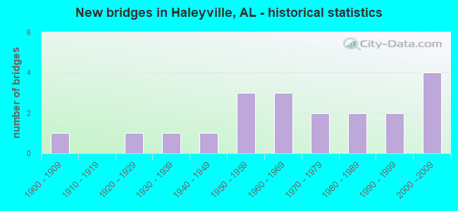
- New bridges - historical statistics
- 11900-1909
- 11920-1929
- 11930-1939
- 11940-1949
- 31950-1959
- 31960-1969
- 21970-1979
- 21980-1989
- 21990-1999
- 42000-2009


- Bridge Condition - Deck
- 14.3%Very good
- 28.6%Good
- 57.1%Satisfactory

- Bridge Condition - Superstructure
- 14.3%Very good
- 28.6%Good
- 57.1%Satisfactory

- Bridge Condition - Substructure
- 14.3%Very good
- 28.6%Good
- 28.6%Satisfactory
- 28.6%Fair

- Bridge Condition - Channel
- 11.8%Very good
- 41.2%Good
- 41.2%Satisfactory
- 5.9%Fair

- Bridge Condition - Culverts
- 18.2%Very good
- 18.2%Good
- 36.4%Satisfactory
- 27.3%Fair
Find on map >> Show street view
Structure Number: 979, Location: 1 MI S JCT CO RD 69 (Lat: 34.270208, Lng: -87.602761), Route carried "on" structure: County highway 31, Year Built: 1932, Status: Open, Structure Length: 0.70m (2.30ft), Average Daily Traffic: 500 (year 1991), Truck Traffic: 1%, Average Future Daily Traffic: 1,000 (year 2032), Features Intersected: QUARTER CREEK BRANCH
Minimum Vertical Clearance: 30+ m (98+ ft), Kilometerpoint: 0.010, Lanes on structure: 2, Owner: County Highway Agency, Approaching Roadway Width: 6.1m (20.0ft), Material/Design: Concrete, Design/Construction: Slab, Number Of Spans In Main Unit: 2, Length of Maximum Span: 3.7m (12.1ft), Curb-To-Curb Width: 6.1m (20.0ft), Out-to-Out Width: 6.7m (22.0ft)
Condition: Deck: Satisfactory, Superstructure: Satisfactory, Substructure: Satisfactory, Channel: Fair, Operating Rating: 43.5 metric tons, Method Used To Determine Operating Rating: Field evaluation and documented engineering judgment, Inventory Rating: 32.7 metric tons, Method Used To Determine Inventory Rating: Field evaluation and documented engineering judgment, Structural Evaluation: Equal to present minimum criteria, Deck Geometry: High priority of corrective action, Waterway Adequacy: Better than present minimum criteria, Approach Roadway Alignment: Somewhat better than minimum adequacy, Length Of Structure Improvement: 1.34m (4.40ft), Designated Inspection Frequency: Every 24 months, Inspection Date: October 2020, Bridge Improvement Cost: $193,000, Roadway Improvement Cost: $19,000, Total Project Cost: $212,000 ( Estimate for 2022), Deck Structure Type: Concrete Cast-file-Place, Wearing Surface/Protective System: Wearing Surface: Bituminous
Find on map >> Show street view
Structure Number: 332, Location: 2.8 MI S JCT US 278 (Lat: 34.149758, Lng: -86.620108), Route carried "on" structure: State highway 91, Year Built: 1948, Status: Open, Structure Length: 1.10m (3.61ft), Average Daily Traffic: 2,631 (year 2020), Truck Traffic: 10%, Average Future Daily Traffic: 3,683 (year 2040), Design Load: H 15, Features Intersected: BRANCH
Minimum Vertical Clearance: 30+ m (98+ ft), Kilometerpoint: 58.894, Lanes on structure: 2, Owner: State Highway Agency, Approaching Roadway Width: 7.9m (25.9ft), Material/Design: Steel, Design/Construction: Culvert, Number Of Spans In Main Unit: 2, Length of Maximum Span: 4.9m (16.1ft)
Condition: Channel: Satisfactory, Culverts: Fair, Operating Rating: 88.9 metric tons, Method Used To Determine Operating Rating: Load Factor (LF), Inventory Rating: 88.9 metric tons, Method Used To Determine Inventory Rating: Load Factor (LF), Structural Evaluation: Somewhat better than minimum adequacy, Waterway Adequacy: Equal to present minimum criteria, Approach Roadway Alignment: Better than present minimum criteria, Length Of Structure Improvement: 1.77m (5.81ft), Designated Inspection Frequency: Every 24 months, Inspection Date: August 2021, Bridge Improvement Cost: $695,000, Roadway Improvement Cost: $70,000, Total Project Cost: $765,000 ( Estimate for 2022), Wearing Surface/Protective System: Wearing Surface: Bituminous
Find on map >> Show street view
Structure Number: 4309, Location: 2.MI NW AL25 CO 27 (Lat: 33.019089, Lng: -87.078536), Route carried "on" structure: County highway 12, Year Built: 1952, Status: Open, Structure Length: 15.48m (50.79ft), Average Daily Traffic: 262 (year 1989), Truck Traffic: 20%, Average Future Daily Traffic: 400 (year 2030), Design Load: H 15, Features Intersected: CAHABA RIVER
Minimum Vertical Clearance: 30+ m (98+ ft), Kilometerpoint: 0.010, Lanes on structure: 2, Owner: County Highway Agency, Approaching Roadway Width: 9.1m (29.9ft), Material/Design: Steel, Design/Construction: Girder and Floorbeam System, Number Of Spans In Main Unit: 4, Number Of Approach Spans: 4, Length of Maximum Span: 110.3m (361.9ft), Curb or Sidewalk Widths: Left: 0.5m (1.6ft), Right: 0.5m (1.6ft), Curb-To-Curb Width: 7.3m (24.0ft), Out-to-Out Width: 8.9m (29.2ft)
Condition: Deck: Satisfactory, Superstructure: Satisfactory, Substructure: Satisfactory, Channel: Good, Operating Rating: 32.7 metric tons, Method Used To Determine Operating Rating: Load Factor (LF), Inventory Rating: 19.7 metric tons, Method Used To Determine Inventory Rating: Load Factor (LF), Structural Evaluation: Somewhat better than minimum adequacy, Deck Geometry: Somewhat better than minimum adequacy, Waterway Adequacy: Equal to present desirable criteria, Approach Roadway Alignment: Better than present minimum criteria, Length Of Structure Improvement: 16.24m (53.28ft), Designated Inspection Frequency: Every 24 months, Inspection Date: November 2020, Bridge Improvement Cost: $3,230,000, Roadway Improvement Cost: $323,000, Total Project Cost: $3,553,000 ( Estimate for 2022), Deck Structure Type: Concrete Cast-file-Place
Find on map >> Show street view
Structure Number: 473, Location: .1 MI E SR 243 CO B83 JCT (Lat: 34.330050, Lng: -87.579917), Route carried "on" structure: County highway B83, Year Built: 1954, Status: Posted for load, Structure Length: 0.65m (2.13ft), Average Daily Traffic: 256 (year 1993), Truck Traffic: 5%, Average Future Daily Traffic: 345 (year 2032), Features Intersected: STREAM INTO BEAR CREEK
Minimum Vertical Clearance: 30+ m (98+ ft), Kilometerpoint: 0.010, Lanes on structure: 2, Owner: County Highway Agency, Approaching Roadway Width: 7.3m (24.0ft), Material/Design: Wood or Timber, Design/Construction: Stringer/Multi-beam, Number Of Spans In Main Unit: 1, Length of Maximum Span: 6.5m (21.3ft), Curb-To-Curb Width: 6.7m (22.0ft), Out-to-Out Width: 7.2m (23.6ft)
Condition: Deck: Satisfactory, Superstructure: Satisfactory, Substructure: Fair, Channel: Satisfactory, Operating Rating: 19.8 metric tons, Method Used To Determine Operating Rating: Allowable Stress (AS), Inventory Rating: 12.2 metric tons, Method Used To Determine Inventory Rating: Allowable Stress (AS), Structural Evaluation: Meets minimum limits, Deck Geometry: Meets minimum limits, Waterway Adequacy: Better than present minimum criteria, Approach Roadway Alignment: Equal to present minimum criteria, Bridge Posting: Required (Relationship of Operating Rating to Maximum Legal Load: > 39.9% below), Length Of Structure Improvement: 1.27m (4.17ft), Designated Inspection Frequency: Every 24 months, Other Special Inspection Frequency: Every 12 months, Inspection Date: July 2020, Other Special Inspection Date: July 2021, Bridge Improvement Cost: $201,000, Roadway Improvement Cost: $20,000, Total Project Cost: $221,000 ( Estimate for 2022), Deck Structure Type: Concrete Cast-file-Place
Find on map >> Show street view
Structure Number: 7531, Location: 1.5 MI S SR 243 CO RD B85 (Lat: 34.319381, Lng: -87.598383), Route carried "on" structure: County highway B85, Year Built: 1962, Status: Open, Structure Length: 0.98m (3.22ft), Average Daily Traffic: 150 (year 1986), Truck Traffic: 3%, Average Future Daily Traffic: 379 (year 2032), Features Intersected: LITTLE DICE BRANCH
Minimum Vertical Clearance: 30+ m (98+ ft), Kilometerpoint: 0.000, Lanes on structure: 2, Owner: County Highway Agency, Approaching Roadway Width: 7.9m (25.9ft), Material/Design: Steel, Design/Construction: Stringer/Multi-beam, Number Of Spans In Main Unit: 1, Length of Maximum Span: 9.8m (32.2ft), Curb-To-Curb Width: 6.6m (21.7ft), Out-to-Out Width: 7.2m (23.6ft)
Condition: Deck: Satisfactory, Superstructure: Satisfactory, Substructure: Fair, Channel: Good, Operating Rating: 65.1 metric tons, Method Used To Determine Operating Rating: Allowable Stress (AS), Inventory Rating: 44.5 metric tons, Method Used To Determine Inventory Rating: Allowable Stress (AS), Structural Evaluation: Somewhat better than minimum adequacy, Deck Geometry: Meets minimum limits, Waterway Adequacy: Better than present minimum criteria, Approach Roadway Alignment: High priority of corrective action, Length Of Structure Improvement: 1.65m (5.41ft), Designated Inspection Frequency: Every 24 months, Inspection Date: April 2020, Bridge Improvement Cost: $261,000, Roadway Improvement Cost: $26,000, Total Project Cost: $287,000 ( Estimate for 2022), Deck Structure Type: Concrete Cast-file-Place
Find on map >> Show street view
Structure Number: 7805, Location: 5 M N JCT SR243 & SR195 (Lat: 34.327033, Lng: -87.580031), Route carried "on" structure: State highway 243, Year Built: 1962, Status: Open, Structure Length: 1.49m (4.89ft), Average Daily Traffic: 1,600 (year 2021), Truck Traffic: 14%, Average Future Daily Traffic: 1,941 (year 2033), Design Load: HS 20, Features Intersected: BIG BEAR CREEK
Minimum Vertical Clearance: 30+ m (98+ ft), Kilometerpoint: 8.558, Lanes on structure: 2, Owner: State Highway Agency, Approaching Roadway Width: 7.4m (24.3ft), Material/Design: Concrete, Design/Construction: Culvert, Number Of Spans In Main Unit: 3, Length of Maximum Span: 4.6m (15.1ft)
Condition: Channel: Satisfactory, Culverts: Satisfactory, Operating Rating: 66.9 metric tons, Method Used To Determine Operating Rating: Load Factor (LF), Inventory Rating: 40.1 metric tons, Method Used To Determine Inventory Rating: Load Factor (LF), Structural Evaluation: Equal to present minimum criteria, Waterway Adequacy: Equal to present desirable criteria, Approach Roadway Alignment: Better than present minimum criteria, Length Of Structure Improvement: 2.17m (7.12ft), Designated Inspection Frequency: Every 24 months, Inspection Date: April 2021, Bridge Improvement Cost: $676,000, Roadway Improvement Cost: $68,000, Total Project Cost: $744,000 ( Estimate for 2022)
Find on map >> Show street view
Structure Number: 9642, Location: 2 MI S JCT SR 5 (Lat: 34.195444, Lng: -87.600294), Route carried "on" structure: County highway 13, Year Built: 1968, Status: Open, Structure Length: 1.68m (5.51ft), Average Daily Traffic: 200 (year 1991), Truck Traffic: 1%, Average Future Daily Traffic: 400 (year 2032), Design Load: H 15, Features Intersected: BEECH GROVE CREEK
Minimum Vertical Clearance: 7.56m (24.80ft), Kilometerpoint: 0.010, Lanes on structure: 2, Owner: County Highway Agency, Approaching Roadway Width: 5.5m (18.0ft), Skew: 4 degrees, Material/Design: Concrete, Design/Construction: Culvert, Number Of Spans In Main Unit: 3, Length of Maximum Span: 3.7m (12.1ft)
Condition: Channel: Satisfactory, Culverts: Good, Operating Rating: 53.0 metric tons, Method Used To Determine Operating Rating: Load Factor (LF), Inventory Rating: 31.8 metric tons, Method Used To Determine Inventory Rating: Load Factor (LF), Structural Evaluation: Better than present minimum criteria, Waterway Adequacy: Equal to present minimum criteria, Approach Roadway Alignment: Better than present minimum criteria, Length Of Structure Improvement: 2.37m (7.78ft), Designated Inspection Frequency: Every 24 months, Inspection Date: August 2020, Bridge Improvement Cost: $753,000, Roadway Improvement Cost: $75,000, Total Project Cost: $828,000 ( Estimate for 2022)
Find on map >> Show street view
Structure Number: 12036, Location: 2 MI N JCT CO RD 7 (Lat: 34.288639, Lng: -87.627828), Route carried "on" structure: County highway 71, Year Built: 1978, Status: Open, Structure Length: 8.05m (26.41ft), Average Daily Traffic: 300 (year 1991), Truck Traffic: 5%, Average Future Daily Traffic: 750 (year 2032), Design Load: HS 20, Features Intersected: BEAR CREEK, Facility Carried by Structure: CO RD 7
Minimum Vertical Clearance: 0.00m, Kilometerpoint: 0.010, Lanes on structure: 2, Owner: County Highway Agency, Approaching Roadway Width: 7.9m (25.9ft), Material/Design: Steel continuous, Design/Construction: Stringer/Multi-beam, Number Of Spans In Main Unit: 3, Length of Maximum Span: 30.5m (100.1ft), Curb-To-Curb Width: 8.5m (27.9ft), Out-to-Out Width: 8.9m (29.2ft)
Condition: Deck: Good, Superstructure: Good, Substructure: Good, Channel: Good, Operating Rating: 45.5 metric tons, Method Used To Determine Operating Rating: Load Factor (LF), Inventory Rating: 27.3 metric tons, Method Used To Determine Inventory Rating: Load Factor (LF), Structural Evaluation: Equal to present minimum criteria, Deck Geometry: Equal to present minimum criteria, Waterway Adequacy: Superior to present desirable criteria, Approach Roadway Alignment: Equal to present desirable criteria, Length Of Structure Improvement: 9.06m (29.72ft), Designated Inspection Frequency: Every 24 months, Underwater Inspection Frequency: Every 48 months, Inspection Date: Febuary 2022, Underwater Inspection Date: April 2020, Bridge Improvement Cost: $1,801,000, Roadway Improvement Cost: $180,000, Total Project Cost: $1,981,000 ( Estimate for 2022), Deck Structure Type: Concrete Cast-file-Place
Find on map >> Show street view
Structure Number: 12451, Location: .5 MILE NORTH JCT 129 (Lat: 34.210361, Lng: -87.668361), Route carried "on" structure: County highway , Year Built: 1900, Year Reconstructed: 1981, Status: Open, Structure Length: 0.91m (2.99ft), Average Daily Traffic: 125 (year 2001), Truck Traffic: 10%, Average Future Daily Traffic: 246 (year 2035), Design Load: H 20, Features Intersected: Moore Creek, Facility Carried by Structure: County Road 99
Minimum Vertical Clearance: 30+ m (98+ ft), Kilometerpoint: 0.010, Lanes on structure: 2, Owner: County Highway Agency, Approaching Roadway Width: 7.3m (24.0ft), Material/Design: Concrete, Design/Construction: Culvert, Number Of Spans In Main Unit: 3, Length of Maximum Span: 3.0m (9.8ft)
Condition: Channel: Good, Culverts: Satisfactory, Operating Rating: 65.0 metric tons, Method Used To Determine Operating Rating: Load Factor (LF), Inventory Rating: 39.0 metric tons, Method Used To Determine Inventory Rating: Load Factor (LF), Structural Evaluation: Equal to present minimum criteria, Waterway Adequacy: Better than present minimum criteria, Approach Roadway Alignment: Equal to present minimum criteria, Length Of Structure Improvement: 1.58m (5.18ft), Designated Inspection Frequency: Every 24 months, Inspection Date: January 2021, Bridge Improvement Cost: $292,000, Roadway Improvement Cost: $29,000, Total Project Cost: $321,000 ( Estimate for 2022)
Find on map >> Show street view
Structure Number: 12641, Location: 1 MILE NW HALEYVILLE (Lat: 34.239889, Lng: -87.640722), Route carried "on" structure: County highway 85, Year Built: 1982, Status: Open, Structure Length: 0.82m (2.69ft), Average Daily Traffic: 550 (year 2001), Truck Traffic: 40%, Average Future Daily Traffic: 1,079 (year 2035), Design Load: H 20, Features Intersected: Flat Creek
Minimum Vertical Clearance: 30+ m (98+ ft), Kilometerpoint: 0.010, Lanes on structure: 2, Owner: County Highway Agency, Approaching Roadway Width: 9.1m (29.9ft), Material/Design: Steel, Design/Construction: Culvert, Number Of Spans In Main Unit: 3, Length of Maximum Span: 2.1m (6.9ft)
Condition: Channel: Satisfactory, Culverts: Fair, Operating Rating: 36.8 metric tons, Method Used To Determine Operating Rating: Load Factor (LF), Inventory Rating: 32.7 metric tons, Method Used To Determine Inventory Rating: Load Factor (LF), Structural Evaluation: Somewhat better than minimum adequacy, Waterway Adequacy: Equal to present minimum criteria, Approach Roadway Alignment: Better than present minimum criteria, Length Of Structure Improvement: 1.48m (4.86ft), Designated Inspection Frequency: Every 24 months, Inspection Date: January 2021, Bridge Improvement Cost: $341,000, Roadway Improvement Cost: $34,000, Total Project Cost: $375,000 ( Estimate for 2022)
Find on map >> Show street view
Structure Number: 13153, Location: 0.1 MI NORTH OF ST RD 5 (Lat: 34.243583, Lng: -87.661028), Route carried "on" structure: County highway , Year Built: 1970, Year Reconstructed: 1984, Status: Open, Structure Length: 0.79m (2.59ft), Average Daily Traffic: 30 (year 2001), Average Future Daily Traffic: 59 (year 2035), Design Load: H 20, Features Intersected: Flat Creek, Facility Carried by Structure: Slaughter Pen Road
Minimum Vertical Clearance: 30+ m (98+ ft), Kilometerpoint: 0.010, Lanes on structure: 2, Owner: County Highway Agency, Approaching Roadway Width: 8.5m (27.9ft), Material/Design: Concrete, Design/Construction: Culvert, Number Of Spans In Main Unit: 2, Length of Maximum Span: 3.7m (12.1ft)
Condition: Channel: Good, Culverts: Satisfactory, Operating Rating: 48.5 metric tons, Method Used To Determine Operating Rating: Load Factor (LF), Inventory Rating: 45.4 metric tons, Method Used To Determine Inventory Rating: Load Factor (LF), Structural Evaluation: Equal to present minimum criteria, Waterway Adequacy: Better than present minimum criteria, Approach Roadway Alignment: Equal to present minimum criteria, Length Of Structure Improvement: 1.44m (4.72ft), Designated Inspection Frequency: Every 24 months, Inspection Date: January 2021, Bridge Improvement Cost: $217,000, Roadway Improvement Cost: $22,000, Total Project Cost: $239,000 ( Estimate for 2022)
Find on map >> Show street view
Structure Number: 14962, Location: 3.9 M N JCT SR243 & SR195 (Lat: 34.307444, Lng: -87.575083), Route carried "on" structure: State highway 243, Year Built: 1989, Status: Open, Structure Length: 0.91m (2.99ft), Average Daily Traffic: 1,090 (year 2021), Truck Traffic: 22%, Average Future Daily Traffic: 1,322 (year 2033), Design Load: HS 20, Features Intersected: CANADA CREEK
Minimum Vertical Clearance: 30+ m (98+ ft), Kilometerpoint: 6.284, Lanes on structure: 2, Owner: State Highway Agency, Approaching Roadway Width: 9.6m (31.5ft), Skew: 2 degrees, Material/Design: Concrete, Design/Construction: Culvert, Number Of Spans In Main Unit: 2, Length of Maximum Span: 3.7m (12.1ft)
Condition: Channel: Good, Culverts: Satisfactory, Operating Rating: 88.9 metric tons, Method Used To Determine Operating Rating: Load Factor (LF), Inventory Rating: 88.9 metric tons, Method Used To Determine Inventory Rating: Load Factor (LF), Structural Evaluation: Equal to present minimum criteria, Waterway Adequacy: Equal to present desirable criteria, Approach Roadway Alignment: Equal to present desirable criteria, Length Of Structure Improvement: 1.58m (5.18ft), Designated Inspection Frequency: Every 24 months, Inspection Date: April 2021, Bridge Improvement Cost: $1,788,000, Roadway Improvement Cost: $179,000, Total Project Cost: $1,967,000 ( Estimate for 2022)
Find on map >> Show street view
Structure Number: 15654, Location: 0.2MI N JCT SR 5 (Lat: 34.237078, Lng: -87.633683), Route carried "on" structure: County highway 7B, Year Built: 1992, Status: Open, Structure Length: 0.91m (2.99ft), Average Daily Traffic: 100 (year 1991), Average Future Daily Traffic: 250 (year 2032), Design Load: H 15, Features Intersected: FLATT CREEK
Minimum Vertical Clearance: 7.56m (24.80ft), Kilometerpoint: 0.010, Lanes on structure: 2, Owner: County Highway Agency, Approaching Roadway Width: 4.9m (16.1ft), Material/Design: Concrete continuous, Design/Construction: Culvert, Number Of Spans In Main Unit: 2, Length of Maximum Span: 3.0m (9.8ft), Curb-To-Curb Width: 17.5m (57.4ft), Out-to-Out Width: 18.0m (59.1ft)
Condition: Channel: Satisfactory, Culverts: Very good, Operating Rating: 88.9 metric tons, Method Used To Determine Operating Rating: Load Factor (LF), Inventory Rating: 67.2 metric tons, Method Used To Determine Inventory Rating: Load Factor (LF), Structural Evaluation: Equal to present desirable criteria, Waterway Adequacy: Better than present minimum criteria, Approach Roadway Alignment: Better than present minimum criteria, Length Of Structure Improvement: 1.58m (5.18ft), Designated Inspection Frequency: Every 24 months, Inspection Date: January 2021, Bridge Improvement Cost: $520,000, Roadway Improvement Cost: $52,000, Total Project Cost: $572,000 ( Estimate for 2022), Deck Structure Type: Concrete Cast-file-Place
Find on map >> Show street view
Structure Number: 17254, Location: 2.7 MI. W Jasper INT (Lat: 33.862553, Lng: -87.393494), Route carried "on" structure: Interstate 22, Year Built: 2000, Status: Open, Structure Length: 6.84m (22.44ft), Average Daily Traffic: 9,850 (year 2013), Truck Traffic: 24%, Average Future Daily Traffic: 13,345 (year 2040), Design Load: HS 20, Features Intersected: Blackwell Rd
Minimum Vertical Clearance: 23.64m (77.56ft), Kilometerpoint: 88.836, Lanes on structure: 3, Lanes under structure: 3, Base Highway Network: Yes (Inventory Route: IN002, Subroute: 4), Owner: State Highway Agency, Approaching Roadway Width: 17.0m (55.8ft), Material/Design: Prestressed concrete, Design/Construction: Stringer/Multi-beam, Number Of Spans In Main Unit: 3, Length of Maximum Span: 32.0m (105.0ft), Curb-To-Curb Width: 17.0m (55.8ft), Out-to-Out Width: 17.9m (58.7ft)
Condition: Deck: Good, Superstructure: Good, Substructure: Good, Operating Rating: 63.8 metric tons, Method Used To Determine Operating Rating: Load Factor (LF), Inventory Rating: 39.2 metric tons, Method Used To Determine Inventory Rating: Load Factor (LF), Structural Evaluation: Better than present minimum criteria, Deck Geometry: Equal to present minimum criteria, Underclear: Superior to present desirable criteria, Approach Roadway Alignment: Equal to present desirable criteria, Length Of Structure Improvement: 7.88m (25.85ft), Designated Inspection Frequency: Every 24 months, Inspection Date: October 2020, Bridge Improvement Cost: $3,132,000, Roadway Improvement Cost: $313,000, Total Project Cost: $3,445,000 ( Estimate for 2022), Deck Structure Type: Concrete Cast-file-Place
Find on map >> Show street view
Structure Number: 17456, Location: 0.5 MI N OF CO. HWY. 34 (Lat: 34.227278, Lng: -87.672611), Route carried "on" structure: County highway 99, Year Built: 1996, Status: Open, Structure Length: 1.00m (3.28ft), Average Daily Traffic: 100 (year 2001), Average Future Daily Traffic: 196 (year 2035), Design Load: HS 20, Features Intersected: Branch
Minimum Vertical Clearance: 30+ m (98+ ft), Kilometerpoint: 0.000, Lanes on structure: 2, Owner: County Highway Agency, Approaching Roadway Width: 7.3m (24.0ft), Material/Design: Steel, Design/Construction: Culvert, Number Of Spans In Main Unit: 3, Length of Maximum Span: 2.0m (6.6ft)
Condition: Channel: Satisfactory, Culverts: Fair, Operating Rating: 51.7 metric tons, Method Used To Determine Operating Rating: Load Factor (LF), Inventory Rating: 51.1 metric tons, Method Used To Determine Inventory Rating: Load Factor (LF), Structural Evaluation: Somewhat better than minimum adequacy, Waterway Adequacy: Better than present minimum criteria, Approach Roadway Alignment: Better than present minimum criteria, Length Of Structure Improvement: 1.67m (5.48ft), Designated Inspection Frequency: Every 24 months, Inspection Date: January 2021, Bridge Improvement Cost: $309,000, Roadway Improvement Cost: $31,000, Total Project Cost: $340,000 ( Estimate for 2022)
Find on map >> Show street view
Structure Number: 18464, Location: 1 MI. S JCT CO RD 31????? (Lat: 34.256344, Lng: -87.606658), Route carried "on" structure: County highway 69, Year Built: 2002, Status: Open, Structure Length: 0.91m (2.99ft), Average Daily Traffic: 1,000 (year 2001), Average Future Daily Traffic: 1,500 (year 2032), Features Intersected: QUARTER CREEK
Minimum Vertical Clearance: 30+ m (98+ ft), Kilometerpoint: 0.016, Lanes on structure: 2, Owner: County Highway Agency, Approaching Roadway Width: 6.7m (22.0ft), Material/Design: Concrete, Design/Construction: Culvert, Number Of Spans In Main Unit: 2, Length of Maximum Span: 4.6m (15.1ft), Curb-To-Curb Width: 15.5m (50.9ft), Out-to-Out Width: 15.8m (51.8ft)
Condition: Channel: Good, Culverts: Good, Operating Rating: 60.0 metric tons, Method Used To Determine Operating Rating: Load Factor (LF), Inventory Rating: 35.9 metric tons, Method Used To Determine Inventory Rating: Load Factor (LF), Structural Evaluation: Better than present minimum criteria, Deck Geometry: Superior to present desirable criteria, Waterway Adequacy: Equal to present desirable criteria, Approach Roadway Alignment: Better than present minimum criteria, Length Of Structure Improvement: 1.59m (5.22ft), Designated Inspection Frequency: Every 24 months, Inspection Date: January 2021, Bridge Improvement Cost: $476,000, Roadway Improvement Cost: $48,000, Total Project Cost: $524,000 ( Estimate for 2022)
Find on map >> Show street view
Structure Number: 18606, Location: 1.1 MI. S.W. SR.243 CO.69 (Lat: 34.306633, Lng: -87.591781), Route carried "on" structure: County highway 69, Year Built: 2002, Status: Open, Structure Length: 3.51m (11.52ft), Average Daily Traffic: 770 (year 2002), Average Future Daily Traffic: 1,140 (year 2028), Design Load: HS 20, Features Intersected: POSEY CREEK
Minimum Vertical Clearance: 30+ m (98+ ft), Kilometerpoint: 0.016, Lanes on structure: 2, Owner: County Highway Agency, Approaching Roadway Width: 8.5m (27.9ft), Skew: 3 degrees, Material/Design: Prestressed concrete, Design/Construction: Stringer/Multi-beam, Number Of Spans In Main Unit: 1, Length of Maximum Span: 32.5m (106.6ft), Curb-To-Curb Width: 8.5m (27.9ft), Out-to-Out Width: 9.4m (30.8ft)
Condition: Deck: Very good, Superstructure: Very good, Substructure: Very good, Channel: Very good, Operating Rating: 80.7 metric tons, Method Used To Determine Operating Rating: Load Factor (LF), Inventory Rating: 33.0 metric tons, Method Used To Determine Inventory Rating: Load Factor (LF), Structural Evaluation: Equal to present desirable criteria, Deck Geometry: Somewhat better than minimum adequacy, Waterway Adequacy: Superior to present desirable criteria, Approach Roadway Alignment: Equal to present desirable criteria, Length Of Structure Improvement: 4.41m (14.47ft), Designated Inspection Frequency: Every 24 months, Inspection Date: Febuary 2021, Bridge Improvement Cost: $907,000, Roadway Improvement Cost: $91,000, Total Project Cost: $998,000 ( Estimate for 2022), Deck Structure Type: Concrete Cast-file-Place
Find on map >> Show street view
Structure Number: 1961, Location: 3 MI W JCT CORD 32??????? (Lat: 34.201325, Lng: -87.588222), Route carried "on" structure: County highway 30, Year Built: 2006, Status: Open, Structure Length: 1.32m (4.33ft), Average Daily Traffic: 400 (year 2005), Truck Traffic: 10%, Average Future Daily Traffic: 450 (year 2032), Design Load: HS 20, Features Intersected: CLEAR CREEK
Minimum Vertical Clearance: 30+ m (98+ ft), Kilometerpoint: 0.010, Lanes on structure: 2, Owner: County Highway Agency, Approaching Roadway Width: 5.5m (18.0ft), Material/Design: Concrete, Design/Construction: Culvert, Number Of Spans In Main Unit: 3, Length of Maximum Span: 4.3m (14.1ft), Curb-To-Curb Width: 15.8m (51.8ft), Out-to-Out Width: 15.8m (51.8ft)
Condition: Channel: Very good, Culverts: Very good, Operating Rating: 88.9 metric tons, Method Used To Determine Operating Rating: Load Factor (LF), Inventory Rating: 73.4 metric tons, Method Used To Determine Inventory Rating: Load Factor (LF), Structural Evaluation: Equal to present desirable criteria, Deck Geometry: Superior to present desirable criteria, Waterway Adequacy: Equal to present desirable criteria, Approach Roadway Alignment: Equal to present desirable criteria, Length Of Structure Improvement: 1.99m (6.53ft), Designated Inspection Frequency: Every 24 months, Inspection Date: September 2020, Bridge Improvement Cost: $598,000, Roadway Improvement Cost: $60,000, Total Project Cost: $658,000 ( Estimate for 2022), Deck Structure Type: Concrete Cast-file-Place
Find on map >> Show street view
Structure Number: 332, Location: 2 MI N JCT SR 129 (Lat: 34.233944, Lng: -87.633611), Route carried "under" structure: State highway 13, Year Built: 1926, Structure Length: 0. m, Average Daily Traffic: 7,560 (year 2013), Truck Traffic: 15%, Features Intersected: AL. #13, Facility Carried by Structure: SOUTHERN RR
Minimum Vertical Clearance: 4.95m (16.24ft), Kilometerpoint: 436.934, Lanes under structure: 2, Material/Design: Steel, Design/Construction: Stringer/Multi-beam, Length of Maximum Span: 14.0m (45.9ft)
Find on map >> Show street view
Structure Number: 4955, Location: 0.6 MI W JCT SR 5 (Lat: 34.206667, Lng: -87.648333), Route carried "under" structure: State highway 129, Year Built: 1954, Structure Length: 0. m, Average Daily Traffic: 3,930 (year 2013), Truck Traffic: 8%, Features Intersected: AL. # 129, Facility Carried by Structure: SOUTHERN RAILROAD
Minimum Vertical Clearance: 4.62m (15.16ft), Kilometerpoint: 65.006, Lanes under structure: 2, Material/Design: Steel, Design/Construction: Stringer/Multi-beam, Length of Maximum Span: 15.2m (49.9ft)