Bridge Statistics for Hanford, California (CA)
Condition, Traffic, Stress, Structural Evaluation, Project Costs
- National Bridge Inventory (NBI) Statistics
- 19Number of bridges
- 138ft / 41.9mTotal length
- $2,704,000Total costs
- 198,207Total average daily traffic
- 21,538Total average daily truck traffic
- National Bridge Inventory (NBI) Registered Bridges for Hanford
- No street view available for this location
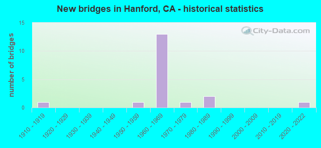
- New bridges - historical statistics
- 11910-1919
- 11950-1959
- 131960-1969
- 11970-1979
- 21980-1989
- 12020-2022

- Reconstructed bridges - Historical Statistics
- 11990-1999
- 02000-2009
- 22010-2019


- Bridge Condition - Deck
- 70.0%Good
- 10.0%Satisfactory
- 10.0%Fair
- 10.0%Poor

- Bridge Condition - Superstructure
- 90.0%Good
- 10.0%Fair

- Bridge Condition - Channel
- 42.9%Good
- 42.9%Satisfactory
- 14.3%Fair

- Bridge Condition - Culverts
- 25.0%Good
- 75.0%Satisfactory
Find on map >> Show street view
Structure Number: 45 0013, Location: 06-KIN-198-R18.13-HAN (Lat: 36.321831, Lng: -119.651447), Route carried "on" structure: State highway 198, Year Built: 1967, Status: Open, Structure Length: 5.33m (17.49ft), Average Daily Traffic: 20,500 (year 2009), Truck Traffic: 14%, Average Future Daily Traffic: 42,658 (year 2043), Design Load: HS 20+Mod, Features Intersected: BNSF RY & AMTRAK
Minimum Vertical Clearance: 30+ m (98+ ft), Kilometerpoint: 18.130, Lanes on structure: 4, Base Highway Network: Yes (Inventory Route: 1, Subroute: 1), Owner: State Highway Agency, Approaching Roadway Width: 29.0m (95.1ft), Skew: 30 degrees, Material/Design: Concrete continuous, Design/Construction: Tee Beam, Number Of Spans In Main Unit: 3, Length of Maximum Span: 20.7m (67.9ft), Curb-To-Curb Width: 29.0m (95.1ft), Out-to-Out Width: 30.2m (99.1ft)
Condition: Deck: Poor, Superstructure: Good, Substructure: Good, Operating Rating: 32.7 metric tons, Method Used To Determine Operating Rating: Load and Resistance Factor Rating (LRFR) rating reported by rating factor(RF) method using HL-93 loadings, Inventory Rating: 25.3 metric tons, Method Used To Determine Inventory Rating: Load and Resistance Factor Rating (LRFR) rating reported by rating factor(RF) method using HL-93 loadings, Structural Evaluation: Equal to present minimum criteria, Deck Geometry: Superior to present desirable criteria, Underclear: Equal to present minimum criteria, Approach Roadway Alignment: Equal to present desirable criteria, Length Of Structure Improvement: 5.33m (17.49ft), Designated Inspection Frequency: Every 24 months, Inspection Date: Febuary 2021, Bridge Improvement Cost: $1,610,000, Roadway Improvement Cost: $322,000, Total Project Cost: $2,704,000 ( Estimate for 2020), Deck Structure Type: Concrete Cast-file-Place, Wearing Surface/Protective System: Wearing Surface: Bituminous
Find on map >> Show street view
Structure Number: 45 0015, Location: 06-KIN-198-R18.23-HAN (Lat: 36.322094, Lng: -119.649772), Route carried "on" structure: State highway 198, Year Built: 1967, Status: Open, Structure Length: 3.29m (10.79ft), Average Daily Traffic: 20,500 (year 2009), Truck Traffic: 14%, Average Future Daily Traffic: 42,658 (year 2043), Design Load: HS 20, Features Intersected: PHILLIPS STREET
Minimum Vertical Clearance: 30+ m (98+ ft), Kilometerpoint: 18.230, Lanes on structure: 5, Lanes under structure: 2, Base Highway Network: Yes (Inventory Route: 1, Subroute: 1), Owner: State Highway Agency, Approaching Roadway Width: 32.0m (105.0ft), Skew: 30 degrees, Material/Design: Concrete continuous, Design/Construction: Tee Beam, Number Of Spans In Main Unit: 3, Length of Maximum Span: 15.5m (50.9ft), Curb-To-Curb Width: 31.7m (104.0ft), Out-to-Out Width: 32.9m (107.9ft)
Condition: Deck: Good, Superstructure: Good, Substructure: Good, Operating Rating: 38.6 metric tons, Method Used To Determine Operating Rating: Load and Resistance Factor Rating (LRFR) rating reported by rating factor(RF) method using HL-93 loadings, Inventory Rating: 29.2 metric tons, Method Used To Determine Inventory Rating: Load and Resistance Factor Rating (LRFR) rating reported by rating factor(RF) method using HL-93 loadings, Structural Evaluation: Better than present minimum criteria, Deck Geometry: Superior to present desirable criteria, Underclear: Meets minimum limits, Approach Roadway Alignment: Equal to present desirable criteria, Designated Inspection Frequency: Every 24 months, Inspection Date: Febuary 2021, Deck Structure Type: Concrete Cast-file-Place, Wearing Surface/Protective System: Wearing Surface: Bituminous
Find on map >> Show street view
Structure Number: 45 0037, Location: 06-KIN-198-R18.51-HAN (Lat: 36.323114, Lng: -119.644989), Route carried "on" structure: City street Z423, Year Built: 1967, Status: Open, Structure Length: 4.97m (16.31ft), Average Daily Traffic: 7,000 (year 1998), Truck Traffic: 3%, Average Future Daily Traffic: 8,782 (year 2041), Design Load: HS 20, Features Intersected: STATE ROUTE 198, Facility Carried by Structure: DOUTY ST
Minimum Vertical Clearance: 30+ m (98+ ft), Kilometerpoint: 0.000, Lanes on structure: 4, Lanes under structure: 4, Owner: State Highway Agency, Approaching Roadway Width: 19.5m (64.0ft), Material/Design: Concrete continuous, Design/Construction: Tee Beam, Number Of Spans In Main Unit: 4, Length of Maximum Span: 14.2m (46.6ft), Curb or Sidewalk Widths: Left: 1.5m (4.9ft), Right: 1.5m (4.9ft), Curb-To-Curb Width: 19.5m (64.0ft), Out-to-Out Width: 23.7m (77.8ft)
Condition: Deck: Good, Superstructure: Good, Substructure: Good, Operating Rating: 51.8 metric tons, Method Used To Determine Operating Rating: Load Factor (LF), Inventory Rating: 30.8 metric tons, Method Used To Determine Inventory Rating: Load Factor (LF), Structural Evaluation: Better than present minimum criteria, Deck Geometry: Better than present minimum criteria, Underclear: High priority of corrective action, Approach Roadway Alignment: Equal to present desirable criteria, Designated Inspection Frequency: Every 24 months, Inspection Date: Febuary 2021, Deck Structure Type: Concrete Cast-file-Place, Wearing Surface/Protective System: Wearing Surface: Bituminous
Find on map >> Show street view
Structure Number: 45 0038, Location: 06-KIN-198-R17.91-HAN (Lat: 36.321222, Lng: -119.655353), Route carried "on" structure: State highway 198, Year Built: 1967, Year Reconstructed: 2015, Status: Open, Structure Length: 5.00m (16.40ft), Average Daily Traffic: 27,500 (year 2009), Truck Traffic: 9%, Average Future Daily Traffic: 51,264 (year 2043), Design Load: HS 20+Mod, Features Intersected: 11TH AVENUE
Minimum Vertical Clearance: 30+ m (98+ ft), Kilometerpoint: 17.910, Lanes on structure: 4, Lanes under structure: 5, Base Highway Network: Yes (Inventory Route: 1, Subroute: 1), Owner: State Highway Agency, Approaching Roadway Width: 26.2m (86.0ft), Skew: 30 degrees, Material/Design: Concrete continuous, Design/Construction: Tee Beam, Number Of Spans In Main Unit: 4, Length of Maximum Span: 16.5m (54.1ft), Curb-To-Curb Width: 25.6m (84.0ft), Out-to-Out Width: 27.1m (88.9ft)
Condition: Deck: Good, Superstructure: Good, Substructure: Good, Operating Rating: 37.9 metric tons, Method Used To Determine Operating Rating: Load and Resistance Factor Rating (LRFR) rating reported by rating factor(RF) method using HL-93 loadings, Inventory Rating: 27.5 metric tons, Method Used To Determine Inventory Rating: Load and Resistance Factor Rating (LRFR) rating reported by rating factor(RF) method using HL-93 loadings, Structural Evaluation: Equal to present minimum criteria, Deck Geometry: Superior to present desirable criteria, Underclear: Somewhat better than minimum adequacy, Approach Roadway Alignment: Equal to present desirable criteria, Designated Inspection Frequency: Every 24 months, Inspection Date: Febuary 2021, Deck Structure Type: Concrete Cast-file-Place, Wearing Surface/Protective System: Wearing Surface: Integral Concrete
Find on map >> Show street view
Structure Number: 45 0039, Location: 06-KIN-198-R18.96-HAN (Lat: 36.324400, Lng: -119.637106), Route carried "on" structure: City street Z424, Year Built: 1967, Status: Open, Structure Length: 5.33m (17.49ft), Average Daily Traffic: 7,000 (year 1998), Truck Traffic: 3%, Average Future Daily Traffic: 8,782 (year 2041), Design Load: HS 20+Mod, Features Intersected: STATE ROUTE 198, Facility Carried by Structure: 10TH AVENUE
Minimum Vertical Clearance: 30+ m (98+ ft), Kilometerpoint: 0.000, Lanes on structure: 5, Lanes under structure: 4, Owner: State Highway Agency, Approaching Roadway Width: 25.6m (84.0ft), Skew: 21 degrees, Material/Design: Concrete continuous, Design/Construction: Tee Beam, Number Of Spans In Main Unit: 4, Length of Maximum Span: 14.9m (48.9ft), Curb or Sidewalk Widths: Left: 1.5m (4.9ft), Right: 1.5m (4.9ft), Curb-To-Curb Width: 25.6m (84.0ft), Out-to-Out Width: 29.8m (97.8ft)
Condition: Deck: Good, Superstructure: Good, Substructure: Good, Operating Rating: 38.6 metric tons, Method Used To Determine Operating Rating: Load and Resistance Factor Rating (LRFR) rating reported by rating factor(RF) method using HL-93 loadings, Inventory Rating: 26.9 metric tons, Method Used To Determine Inventory Rating: Load and Resistance Factor Rating (LRFR) rating reported by rating factor(RF) method using HL-93 loadings, Structural Evaluation: Equal to present minimum criteria, Deck Geometry: Superior to present desirable criteria, Underclear: Meets minimum limits, Approach Roadway Alignment: Equal to present desirable criteria, Designated Inspection Frequency: Every 24 months, Inspection Date: Febuary 2021, Deck Structure Type: Concrete Cast-file-Place, Wearing Surface/Protective System: Wearing Surface: Bituminous
Find on map >> Show street view
Structure Number: 45 0061, Location: 06-KIN-043-23.50 (Lat: 36.387125, Lng: -119.637003), Route carried "on" structure: State highway 43, Year Built: 1916, Year Reconstructed: 1995, Status: Open, Structure Length: 1.01m (3.31ft), Average Daily Traffic: 10,200 (year 2009), Average Future Daily Traffic: 22,275 (year 2038), Features Intersected: PEOPLES DITCH
Minimum Vertical Clearance: 30+ m (98+ ft), Kilometerpoint: 23.500, Lanes on structure: 2, Base Highway Network: Yes (, Subroute: 1), Owner: State Highway Agency, Approaching Roadway Width: 12.2m (40.0ft), Skew: 1 degrees, Material/Design: Concrete, Design/Construction: Arch - Deck, Number Of Spans In Main Unit: 2, Length of Maximum Span: 4.9m (16.1ft)
Condition: Deck: Good, Superstructure: Good, Substructure: Good, Channel: Good, Operating Rating: 40.5 metric tons, Method Used To Determine Operating Rating: Field evaluation and documented engineering judgment, Inventory Rating: 24.3 metric tons, Method Used To Determine Inventory Rating: Field evaluation and documented engineering judgment, Structural Evaluation: Equal to present minimum criteria, Waterway Adequacy: Equal to present desirable criteria, Approach Roadway Alignment: Equal to present desirable criteria, Designated Inspection Frequency: Every 24 months, Inspection Date: December 2020
Find on map >> Show street view
Structure Number: 45 008, Location: 06-KIN-043-18.22 (Lat: 36.324944, Lng: -119.600853), Route carried "on" structure: State highway 43, Year Built: 1967, Status: Open, Structure Length: 6.43m (21.10ft), Average Daily Traffic: 8,590 (year 2009), Truck Traffic: 20%, Average Future Daily Traffic: 11,249 (year 2042), Design Load: HS 20+Mod, Features Intersected: SR 198
Minimum Vertical Clearance: 30+ m (98+ ft), Kilometerpoint: 18.220, Lanes on structure: 2, Lanes under structure: 6, Base Highway Network: Yes (, Subroute: 1), Owner: State Highway Agency, Approaching Roadway Width: 12.2m (40.0ft), Skew: 2 degrees, Material/Design: Concrete continuous, Design/Construction: Tee Beam, Number Of Spans In Main Unit: 4, Length of Maximum Span: 21.3m (69.9ft), Curb-To-Curb Width: 12.2m (40.0ft), Out-to-Out Width: 12.8m (42.0ft)
Condition: Deck: Satisfactory, Superstructure: Good, Substructure: Good, Operating Rating: 43.4 metric tons, Method Used To Determine Operating Rating: Load and Resistance Factor Rating (LRFR) rating reported by rating factor(RF) method using HL-93 loadings, Inventory Rating: 33.4 metric tons, Method Used To Determine Inventory Rating: Load and Resistance Factor Rating (LRFR) rating reported by rating factor(RF) method using HL-93 loadings, Structural Evaluation: Better than present minimum criteria, Deck Geometry: Somewhat better than minimum adequacy, Underclear: Equal to present minimum criteria, Approach Roadway Alignment: Equal to present desirable criteria, Designated Inspection Frequency: Every 24 months, Inspection Date: December 2020, Deck Structure Type: Concrete Cast-file-Place
Find on map >> Show street view
Structure Number: 45 0099, Location: 06-KIN-198-R16.91 (Lat: 36.318808, Lng: -119.673072), Route carried "on" structure: County highway , Year Built: 1985, Year Reconstructed: 2016, Status: Open, Structure Length: 4.48m (14.70ft), Average Daily Traffic: 9,000 (year 1998), Truck Traffic: 5%, Average Future Daily Traffic: 10,977 (year 2041), Design Load: HS 20+Mod, Features Intersected: STATE ROUTE 198, Facility Carried by Structure: 12TH AVE OC
Minimum Vertical Clearance: 30+ m (98+ ft), Kilometerpoint: 0.000, Lanes on structure: 4, Lanes under structure: 4, Base Highway Network: Yes, Owner: State Highway Agency, Approaching Roadway Width: 26.8m (87.9ft), Skew: 21 degrees, Material/Design: Concrete continuous, Design/Construction: Box Beam or Girders - Multiple, Number Of Spans In Main Unit: 2, Length of Maximum Span: 22.5m (73.8ft), Curb or Sidewalk Widths: Left: 2.4m (7.9ft), Right: 2.4m (7.9ft), Curb-To-Curb Width: 26.8m (87.9ft), Out-to-Out Width: 33.5m (109.9ft)
Condition: Deck: Good, Superstructure: Good, Substructure: Good, Operating Rating: 54.1 metric tons, Method Used To Determine Operating Rating: Assigned rating based on Load Factor Design (LFD) reported in metric tons, Inventory Rating: 32.4 metric tons, Method Used To Determine Inventory Rating: Assigned rating based on Load Factor Design (LFD) reported in metric tons, Structural Evaluation: Better than present minimum criteria, Deck Geometry: Superior to present desirable criteria, Underclear: High priority of corrective action, Approach Roadway Alignment: Equal to present minimum criteria, Designated Inspection Frequency: Every 24 months, Inspection Date: Febuary 2021, Deck Structure Type: Concrete Cast-file-Place
Find on map >> Show street view
Structure Number: 45C0051, Location: 0.6 MI S OF LACY BLVD (Lat: 36.319622, Lng: -119.565083), Route carried "on" structure: County highway , Year Built: 1959, Status: Open, Structure Length: 0.82m (2.69ft), Average Daily Traffic: 750 (year 2017), Truck Traffic: 10%, Average Future Daily Traffic: 373 (year 2039), Features Intersected: LAKESIDE DITCH, Facility Carried by Structure: 6TH AVE
Minimum Vertical Clearance: 30+ m (98+ ft), Kilometerpoint: 0.000, Lanes on structure: 2, Owner: County Highway Agency, Approaching Roadway Width: 6.3m (20.7ft), Skew: 1 degrees, Material/Design: Concrete continuous, Design/Construction: Culvert, Number Of Spans In Main Unit: 3, Length of Maximum Span: 2.7m (8.9ft), Curb-To-Curb Width: 6.5m (21.3ft), Out-to-Out Width: 12.3m (40.4ft)
Condition: Channel: Fair, Culverts: Satisfactory, Operating Rating: 40.5 metric tons, Method Used To Determine Operating Rating: Field evaluation and documented engineering judgment, Inventory Rating: 24.3 metric tons, Method Used To Determine Inventory Rating: Field evaluation and documented engineering judgment, Structural Evaluation: Equal to present minimum criteria, Deck Geometry: High priority of corrective action, Waterway Adequacy: Meets minimum limits, Approach Roadway Alignment: Equal to present desirable criteria, Designated Inspection Frequency: Every 24 months, Inspection Date: November 2021, Deck Structure Type: Concrete Cast-file-Place, Wearing Surface/Protective System: Wearing Surface: Bituminous
Find on map >> Show street view
Structure Number: 45C0076, Location: 0.2 MI E OF 11TH AVE (Lat: 36.211136, Lng: -119.650619), Route carried "on" structure: County highway , Year Built: 1963, Status: Open, Structure Length: 0.66m (2.17ft), Average Daily Traffic: 3,270 (year 2019), Truck Traffic: 20%, Average Future Daily Traffic: 2,130 (year 2040), Features Intersected: CLARK DITCH, Facility Carried by Structure: KANSAS AVE
Minimum Vertical Clearance: 30+ m (98+ ft), Kilometerpoint: 0.000, Lanes on structure: 2, Owner: County Highway Agency, Approaching Roadway Width: 8.2m (26.9ft), Material/Design: Concrete continuous, Design/Construction: Culvert, Number Of Spans In Main Unit: 2, Length of Maximum Span: 3.2m (10.5ft), Curb-To-Curb Width: 15.4m (50.5ft), Out-to-Out Width: 16.0m (52.5ft)
Condition: Channel: Satisfactory, Culverts: Satisfactory, Operating Rating: 40.5 metric tons, Method Used To Determine Operating Rating: Field evaluation and documented engineering judgment, Inventory Rating: 24.3 metric tons, Method Used To Determine Inventory Rating: Field evaluation and documented engineering judgment, Structural Evaluation: Equal to present minimum criteria, Deck Geometry: Superior to present desirable criteria, Waterway Adequacy: Equal to present desirable criteria, Approach Roadway Alignment: Equal to present desirable criteria, Designated Inspection Frequency: Every 24 months, Inspection Date: November 2021
Find on map >> Show street view
Structure Number: 45C0091, Location: 0.2 MI W/O SR 43 (Lat: 36.386542, Lng: -119.639147), Route carried "on" structure: County highway , Year Built: 1977, Status: Open, Structure Length: 1.12m (3.67ft), Average Daily Traffic: 450 (year 2017), Truck Traffic: 10%, Average Future Daily Traffic: 423 (year 2039), Features Intersected: PEOPLES DITCH, Facility Carried by Structure: ELDER AVE
Minimum Vertical Clearance: 30+ m (98+ ft), Kilometerpoint: 0.000, Lanes on structure: 2, Owner: County Highway Agency, Approaching Roadway Width: 6.6m (21.7ft), Skew: 5 degrees, Material/Design: Concrete, Design/Construction: Slab, Number Of Spans In Main Unit: 1, Length of Maximum Span: 10.7m (35.1ft), Curb-To-Curb Width: 9.7m (31.8ft), Out-to-Out Width: 9.9m (32.5ft)
Condition: Deck: Fair, Superstructure: Fair, Substructure: Good, Channel: Satisfactory, Operating Rating: 54.1 metric tons, Method Used To Determine Operating Rating: Field evaluation and documented engineering judgment, Inventory Rating: 32.4 metric tons, Method Used To Determine Inventory Rating: Field evaluation and documented engineering judgment, Structural Evaluation: Somewhat better than minimum adequacy, Deck Geometry: Equal to present minimum criteria, Waterway Adequacy: Equal to present minimum criteria, Approach Roadway Alignment: Equal to present desirable criteria, Designated Inspection Frequency: Every 24 months, Inspection Date: November 2021, Deck Structure Type: Concrete Cast-file-Place
Find on map >> Show street view
Structure Number: 45C0104, Location: ADJACENT TO 13TH AVE (Lat: 36.371656, Lng: -119.691311), Route carried "on" structure: County highway , Year Built: 1961, Status: Open, Structure Length: 0.96m (3.15ft), Average Daily Traffic: 750 (year 2018), Truck Traffic: 15%, Average Future Daily Traffic: 627 (year 2042), Design Load: H 15, Features Intersected: LAST CHANCE DITCH, Facility Carried by Structure: FLINT AVE
Minimum Vertical Clearance: 30+ m (98+ ft), Kilometerpoint: 0.000, Lanes on structure: 2, Owner: County Highway Agency, Approaching Roadway Width: 10.0m (32.8ft), Material/Design: Steel, Design/Construction: Stringer/Multi-beam, Number Of Spans In Main Unit: 1, Length of Maximum Span: 9.0m (29.5ft), Curb or Sidewalk Widths: Left: 0.3m (1.0ft), Right: 0.3m (1.0ft), Curb-To-Curb Width: 10.0m (32.8ft), Out-to-Out Width: 10.6m (34.8ft)
Condition: Deck: Good, Superstructure: Good, Substructure: Good, Channel: Satisfactory, Operating Rating: 52.2 metric tons, Method Used To Determine Operating Rating: Load Factor (LF), Inventory Rating: 31.1 metric tons, Method Used To Determine Inventory Rating: Load Factor (LF), Structural Evaluation: Better than present minimum criteria, Deck Geometry: Equal to present minimum criteria, Waterway Adequacy: Better than present minimum criteria, Approach Roadway Alignment: Equal to present desirable criteria, Designated Inspection Frequency: Every 24 months, Inspection Date: September 2020, Deck Structure Type: Concrete Cast-file-Place, Wearing Surface/Protective System: Wearing Surface: Bituminous
Find on map >> Show street view
Structure Number: 45C0135, Location: 0.35 MI S OF ELDER AVE (Lat: 36.381294, Lng: -119.654925), Route carried "on" structure: County highway , Year Built: 1960, Status: Open, Structure Length: 1.19m (3.90ft), Average Daily Traffic: 3,377 (year 2017), Truck Traffic: 15%, Average Future Daily Traffic: 2,879 (year 2039), Features Intersected: PEOPLES DITCH, Facility Carried by Structure: 11TH AVE
Minimum Vertical Clearance: 30+ m (98+ ft), Kilometerpoint: 0.000, Lanes on structure: 2, Owner: County Highway Agency, Approaching Roadway Width: 7.7m (25.3ft), Skew: 4 degrees, Material/Design: Concrete continuous, Design/Construction: Culvert, Number Of Spans In Main Unit: 3, Length of Maximum Span: 3.8m (12.5ft), Curb-To-Curb Width: 13.7m (44.9ft), Out-to-Out Width: 14.3m (46.9ft)
Condition: Channel: Good, Culverts: Satisfactory, Operating Rating: 40.5 metric tons, Method Used To Determine Operating Rating: Field evaluation and documented engineering judgment, Inventory Rating: 24.3 metric tons, Method Used To Determine Inventory Rating: Field evaluation and documented engineering judgment, Structural Evaluation: Equal to present minimum criteria, Deck Geometry: Superior to present desirable criteria, Waterway Adequacy: Equal to present desirable criteria, Approach Roadway Alignment: Equal to present desirable criteria, Designated Inspection Frequency: Every 24 months, Inspection Date: November 2021
Find on map >> Show street view
Structure Number: 45C0144, Location: E/O 8TH AVE (Lat: 36.401236, Lng: -119.599514), Route carried "on" structure: County highway , Year Built: 2020, Status: Open, Structure Length: 1.33m (4.36ft), Average Daily Traffic: 700 (year 2021), Truck Traffic: 15%, Average Future Daily Traffic: 900 (year 2041), Design Load: HS 20+Mod, Features Intersected: PEOPLES DITCH, Facility Carried by Structure: EXCELSIOR AVE
Minimum Vertical Clearance: 30+ m (98+ ft), Kilometerpoint: 0.000, Lanes on structure: 2, Base Highway Network: Yes, Owner: County Highway Agency, Approaching Roadway Width: 7.3m (24.0ft), Skew: 5 degrees, Material/Design: Concrete, Design/Construction: Culvert, Number Of Spans In Main Unit: 3, Length of Maximum Span: 4.3m (14.1ft), Curb-To-Curb Width: 99.9m (327.8ft), Out-to-Out Width: 127.3m (417.7ft)
Condition: Channel: Good, Culverts: Good, Operating Rating: 54.1 metric tons, Method Used To Determine Operating Rating: Field evaluation and documented engineering judgment, Inventory Rating: 32.4 metric tons, Method Used To Determine Inventory Rating: Field evaluation and documented engineering judgment, Structural Evaluation: Better than present minimum criteria, Deck Geometry: Superior to present desirable criteria, Waterway Adequacy: Equal to present desirable criteria, Approach Roadway Alignment: Equal to present desirable criteria, Designated Inspection Frequency: Every 24 months, Inspection Date: November 2021
Find on map >> Show street view
Structure Number: 45 0037, Location: 06-KIN-198-R18.51-HAN (Lat: 36.323114, Lng: -119.644989), Route carried "under" structure: State highway 198, Year Built: 1967, Structure Length: 0. m, Average Daily Traffic: 20,500 (year 2009), Truck Traffic: 14%, Features Intersected: STATE ROUTE 198, Facility Carried by Structure: DOUTY ST
Minimum Vertical Clearance: 4.52m (14.83ft), Kilometerpoint: 18.510, Lanes on structure: 4, Lanes under structure: 4, Material/Design: Concrete continuous, Design/Construction: Tee Beam, Length of Maximum Span: 14.2m (46.6ft)
Find on map >> Show street view
Structure Number: 45 0038, Location: 06-KIN-198-R17.91-HAN (Lat: 36.321222, Lng: -119.655353), Route carried "under" structure: County highway Z419, Year Built: 1967, Structure Length: 0. m, Average Daily Traffic: 1,000 (year 1998), Truck Traffic: 2%, Features Intersected: 11TH AVENUE, Facility Carried by Structure: STATE ROUTE 198
Minimum Vertical Clearance: 4.85m (15.91ft), Kilometerpoint: 0.000, Lanes on structure: 4, Lanes under structure: 5, Material/Design: Concrete continuous, Design/Construction: Tee Beam, Length of Maximum Span: 16.5m (54.1ft)
Find on map >> Show street view
Structure Number: 45 0039, Location: 06-KIN-198-R18.96-HAN (Lat: 36.324400, Lng: -119.637106), Route carried "under" structure: State highway 198, Year Built: 1967, Structure Length: 0. m, Average Daily Traffic: 20,500 (year 2009), Truck Traffic: 14%, Features Intersected: STATE ROUTE 198, Facility Carried by Structure: 10TH AVENUE
Minimum Vertical Clearance: 4.59m (15.06ft), Kilometerpoint: 18.960, Lanes on structure: 5, Lanes under structure: 4, Material/Design: Concrete continuous, Design/Construction: Tee Beam, Length of Maximum Span: 14.9m (48.9ft)
Find on map >> Show street view
Structure Number: 45 008, Location: 06-KIN-043-18.22 (Lat: 36.324944, Lng: -119.600853), Route carried "under" structure: State highway 198, Year Built: 1967, Structure Length: 0. m, Average Daily Traffic: 9,120 (year 2009), Truck Traffic: 11%, Features Intersected: SR 198, Facility Carried by Structure: SR 43
Minimum Vertical Clearance: 4.85m (15.91ft), Kilometerpoint: 20.980, Lanes on structure: 2, Lanes under structure: 6, Material/Design: Concrete continuous, Design/Construction: Tee Beam, Length of Maximum Span: 21.3m (69.9ft)
Find on map >> Show street view
Structure Number: 45 0099, Location: 06-KIN-198-R16.91 (Lat: 36.318808, Lng: -119.673072), Route carried "under" structure: State highway 198, Year Built: 1985, Structure Length: 0. m, Average Daily Traffic: 27,500 (year 2009), Truck Traffic: 9%, Features Intersected: STATE ROUTE 198, Facility Carried by Structure: 12TH AVE OC
Minimum Vertical Clearance: 5.03m (16.50ft), Kilometerpoint: 16.910, Lanes on structure: 4, Lanes under structure: 4, Material/Design: Concrete continuous, Design/Construction: Box Beam or Girders - Multiple, Length of Maximum Span: 22.5m (73.8ft)