Bridge Statistics for Harrison, Michigan (MI)
Condition, Traffic, Stress, Structural Evaluation, Project Costs
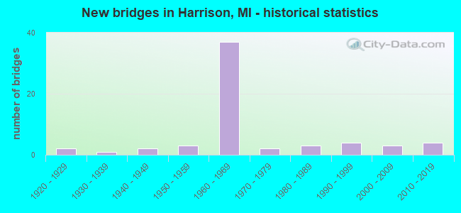
- New bridges - historical statistics
- 21920-1929
- 11930-1939
- 21940-1949
- 31950-1959
- 371960-1969
- 21970-1979
- 31980-1989
- 41990-1999
- 32000-2009
- 42010-2019

- Reconstructed bridges - Historical Statistics
- 11960-1969
- 11970-1979
- 21980-1989
- 41990-1999
- 72000-2009


- Bridge Condition - Deck
- 15.4%Very good
- 30.8%Good
- 33.3%Satisfactory
- 20.5%Fair

- Bridge Condition - Superstructure
- 17.9%Very good
- 28.2%Good
- 25.6%Satisfactory
- 23.1%Fair
- 2.6%Serious
- 2.6%Critical

- Bridge Condition - Substructure
- 12.8%Very good
- 25.6%Good
- 41.0%Satisfactory
- 15.4%Fair
- 5.1%Poor

- Bridge Condition - Channel
- 45.0%Very good
- 30.0%Good
- 20.0%Satisfactory
- 5.0%Fair
Find on map >> Show street view
Structure Number: 1712, Location: 2.3 MI S OF M-61 (Lat: 43.956078, Lng: -84.777222), Route carried "on" structure: County highway 1840, Year Built: 1966, Status: Open, Structure Length: 3.96m (12.99ft), Average Daily Traffic: 1,000 (year 1996), Truck Traffic: 3%, Average Future Daily Traffic: 1,500 (year 2010), Design Load: H 15, Features Intersected: US-127 SB, Facility Carried by Structure: MANNSIDING RD
Minimum Vertical Clearance: 30.48m (100.00ft), Kilometerpoint: 9.074, Lanes on structure: 2, Lanes under structure: 2, Owner: State Highway Agency, Approaching Roadway Width: 10.3m (33.8ft), Skew: 1 degrees, Material/Design: Prestressed concrete, Design/Construction: Stringer/Multi-beam, Number Of Spans In Main Unit: 3, Length of Maximum Span: 18.6m (61.0ft), Curb or Sidewalk Widths: Left: 0.4m (1.3ft), Right: 0.4m (1.3ft), Curb-To-Curb Width: 7.9m (25.9ft), Out-to-Out Width: 9.5m (31.2ft)
Condition: Deck: Satisfactory, Superstructure: Satisfactory, Substructure: Satisfactory, Operating Rating: 60.6 metric tons, Method Used To Determine Operating Rating: Load Factor (LF) rating reported by rating factor (RF) method using MS18 loading, Inventory Rating: 36.3 metric tons, Method Used To Determine Inventory Rating: Load Factor (LF) rating reported by rating factor (RF) method using MS18 loading, Structural Evaluation: Equal to present minimum criteria, Deck Geometry: Somewhat better than minimum adequacy, Underclear: Meets minimum limits, Approach Roadway Alignment: Equal to present minimum criteria, Designated Inspection Frequency: Every 7 months, Inspection Date: March 2022, Deck Structure Type: Concrete Cast-file-Place, Wearing Surface/Protective System: Wearing Surface: Monolithic Concrete
Find on map >> Show street view
Structure Number: 1713, Location: 2.3 MI S OF M-61 (Lat: 43.956297, Lng: -84.776067), Route carried "on" structure: County highway 1840, Year Built: 1966, Status: Open, Structure Length: 3.99m (13.09ft), Average Daily Traffic: 1,500 (year 2008), Truck Traffic: 3%, Average Future Daily Traffic: 1,600 (year 2018), Design Load: H 15, Features Intersected: US-127 NB, Facility Carried by Structure: MANNSIDING RD
Minimum Vertical Clearance: 30.48m (100.00ft), Kilometerpoint: 9.169, Lanes on structure: 2, Lanes under structure: 2, Owner: State Highway Agency, Approaching Roadway Width: 10.3m (33.8ft), Skew: 1 degrees, Material/Design: Prestressed concrete, Design/Construction: Stringer/Multi-beam, Number Of Spans In Main Unit: 3, Length of Maximum Span: 18.6m (61.0ft), Curb or Sidewalk Widths: Left: 0.4m (1.3ft), Right: 0.4m (1.3ft), Curb-To-Curb Width: 7.9m (25.9ft), Out-to-Out Width: 9.5m (31.2ft)
Condition: Deck: Satisfactory, Superstructure: Fair, Substructure: Good, Operating Rating: 64.8 metric tons, Method Used To Determine Operating Rating: Load Factor (LF) rating reported by rating factor (RF) method using MS18 loading, Inventory Rating: 38.6 metric tons, Method Used To Determine Inventory Rating: Load Factor (LF) rating reported by rating factor (RF) method using MS18 loading, Structural Evaluation: Somewhat better than minimum adequacy, Deck Geometry: Meets minimum limits, Underclear: Somewhat better than minimum adequacy, Approach Roadway Alignment: Equal to present minimum criteria, Designated Inspection Frequency: Every 24 months, Inspection Date: October 2020, Deck Structure Type: Concrete Cast-file-Place, Wearing Surface/Protective System: Wearing Surface: Epoxy Overlay
Find on map >> Show street view
Structure Number: 1718, Location: @ US-127 BR & M-61 (Lat: 43.990650, Lng: -84.776225), Route carried "on" structure: US 127, Year Built: 1961, Year Reconstructed: 2007, Status: Open, Structure Length: 4.78m (15.68ft), Average Daily Traffic: 5,495 (year 2007), Truck Traffic: 10%, Average Future Daily Traffic: 11,400 (year 2027), Design Load: HS 20, Features Intersected: US-127 BR & M-61
Minimum Vertical Clearance: 30.48m (100.00ft), Kilometerpoint: 20.687, Lanes on structure: 3, Lanes under structure: 2, Base Highway Network: Yes (Inventory Route: 104, Subroute: 3), Owner: State Highway Agency, Approaching Roadway Width: 15.8m (51.8ft), Skew: 11 degrees, Material/Design: Prestressed concrete, Design/Construction: Stringer/Multi-beam, Number Of Spans In Main Unit: 3, Length of Maximum Span: 15.9m (52.2ft), Curb-To-Curb Width: 16.5m (54.1ft), Out-to-Out Width: 17.4m (57.1ft)
Condition: Deck: Fair, Superstructure: Fair, Substructure: Satisfactory, Operating Rating: 97.2 metric tons, Method Used To Determine Operating Rating: Load Factor (LF) rating reported by rating factor (RF) method using MS18 loading, Inventory Rating: 51.5 metric tons, Method Used To Determine Inventory Rating: Load Factor (LF) rating reported by rating factor (RF) method using MS18 loading, Structural Evaluation: Somewhat better than minimum adequacy, Deck Geometry: Better than present minimum criteria, Underclear: Somewhat better than minimum adequacy, Approach Roadway Alignment: Equal to present desirable criteria, Designated Inspection Frequency: Every 14 months, Inspection Date: August 2021, Deck Structure Type: Concrete Cast-file-Place, Wearing Surface/Protective System: Wearing Surface: Latex Concrete
Find on map >> Show street view
Structure Number: 1719, Location: @ US-127 BR & M-61 (Lat: 43.990733, Lng: -84.776633), Route carried "on" structure: US 127, Year Built: 1961, Year Reconstructed: 2007, Status: Open, Structure Length: 4.78m (15.68ft), Average Daily Traffic: 6,558 (year 2020), Truck Traffic: 8%, Average Future Daily Traffic: 7,542 (year 2040), Design Load: HS 20, Features Intersected: US-127 BR & M-61
Minimum Vertical Clearance: 30.48m (100.00ft), Kilometerpoint: 20.747, Lanes on structure: 3, Lanes under structure: 2, Base Highway Network: Yes (Inventory Route: 104, Subroute: 8), Owner: State Highway Agency, Approaching Roadway Width: 15.8m (51.8ft), Skew: 11 degrees, Material/Design: Prestressed concrete, Design/Construction: Stringer/Multi-beam, Number Of Spans In Main Unit: 3, Length of Maximum Span: 15.9m (52.2ft), Curb-To-Curb Width: 16.5m (54.1ft), Out-to-Out Width: 17.4m (57.1ft)
Condition: Deck: Fair, Superstructure: Fair, Substructure: Satisfactory, Operating Rating: 89.1 metric tons, Method Used To Determine Operating Rating: Load Factor (LF) rating reported by rating factor (RF) method using MS18 loading, Inventory Rating: 46.0 metric tons, Method Used To Determine Inventory Rating: Load Factor (LF) rating reported by rating factor (RF) method using MS18 loading, Structural Evaluation: Somewhat better than minimum adequacy, Deck Geometry: Better than present minimum criteria, Underclear: Somewhat better than minimum adequacy, Approach Roadway Alignment: Equal to present desirable criteria, Designated Inspection Frequency: Every 14 months, Inspection Date: August 2021, Deck Structure Type: Concrete Cast-file-Place, Wearing Surface/Protective System: Wearing Surface: Latex Concrete
Find on map >> Show street view
Structure Number: 172, Location: 1.3 MI N US-127BR, M-61 (Lat: 44.009733, Lng: -84.776339), Route carried "on" structure: County highway , Year Built: 1966, Status: Open, Structure Length: 3.87m (12.70ft), Average Daily Traffic: 400 (year 2008), Truck Traffic: 3%, Average Future Daily Traffic: 500 (year 2010), Design Load: H 15, Features Intersected: US-127 NB, Facility Carried by Structure: MOSTETLER RD
Minimum Vertical Clearance: 30.48m (100.00ft), Kilometerpoint: 1.732, Lanes on structure: 2, Lanes under structure: 2, Owner: State Highway Agency, Approaching Roadway Width: 10.3m (33.8ft), Material/Design: Prestressed concrete, Design/Construction: Stringer/Multi-beam, Number Of Spans In Main Unit: 3, Length of Maximum Span: 17.9m (58.7ft), Curb or Sidewalk Widths: Left: 0.4m (1.3ft), Right: 0.4m (1.3ft), Curb-To-Curb Width: 7.9m (25.9ft), Out-to-Out Width: 9.5m (31.2ft)
Condition: Deck: Good, Superstructure: Good, Substructure: Good, Operating Rating: 59.3 metric tons, Method Used To Determine Operating Rating: Load Factor (LF) rating reported by rating factor (RF) method using MS18 loading, Inventory Rating: 35.3 metric tons, Method Used To Determine Inventory Rating: Load Factor (LF) rating reported by rating factor (RF) method using MS18 loading, Structural Evaluation: Better than present minimum criteria, Deck Geometry: Somewhat better than minimum adequacy, Underclear: Somewhat better than minimum adequacy, Approach Roadway Alignment: Better than present minimum criteria, Designated Inspection Frequency: Every 24 months, Inspection Date: October 2020, Deck Structure Type: Concrete Cast-file-Place, Wearing Surface/Protective System: Wearing Surface: Monolithic Concrete
Find on map >> Show street view
Structure Number: 1721, Location: 1.3 MI N US-127BR, M-61 (Lat: 44.009714, Lng: -84.777486), Route carried "on" structure: County highway , Year Built: 1966, Status: Open, Structure Length: 3.75m (12.30ft), Average Daily Traffic: 300 (year 1996), Truck Traffic: 3%, Average Future Daily Traffic: 500 (year 2010), Design Load: H 15, Features Intersected: US-127 SB, Facility Carried by Structure: MOSTETLER RD
Minimum Vertical Clearance: 30.48m (100.00ft), Kilometerpoint: 1.640, Lanes on structure: 2, Lanes under structure: 2, Owner: State Highway Agency, Approaching Roadway Width: 10.3m (33.8ft), Material/Design: Prestressed concrete, Design/Construction: Stringer/Multi-beam, Number Of Spans In Main Unit: 3, Length of Maximum Span: 17.9m (58.7ft), Curb or Sidewalk Widths: Left: 0.4m (1.3ft), Right: 0.4m (1.3ft), Curb-To-Curb Width: 7.9m (25.9ft), Out-to-Out Width: 9.5m (31.2ft)
Condition: Deck: Good, Superstructure: Satisfactory, Substructure: Satisfactory, Operating Rating: 61.9 metric tons, Method Used To Determine Operating Rating: Load Factor (LF) rating reported by rating factor (RF) method using MS18 loading, Inventory Rating: 27.5 metric tons, Method Used To Determine Inventory Rating: Load Factor (LF) rating reported by rating factor (RF) method using MS18 loading, Structural Evaluation: Equal to present minimum criteria, Deck Geometry: Somewhat better than minimum adequacy, Underclear: Somewhat better than minimum adequacy, Approach Roadway Alignment: Better than present minimum criteria, Designated Inspection Frequency: Every 24 months, Inspection Date: October 2020, Deck Structure Type: Concrete Cast-file-Place, Wearing Surface/Protective System: Wearing Surface: Monolithic Concrete
Find on map >> Show street view
Structure Number: 1722, Location: 3.0 MI N M-61 (Lat: 44.031619, Lng: -84.778383), Route carried "on" structure: County highway 1860, Year Built: 1964, Status: Open, Structure Length: 7.25m (23.79ft), Average Daily Traffic: 1,800 (year 1996), Truck Traffic: 20%, Average Future Daily Traffic: 2,000 (year 2010), Design Load: H 15, Features Intersected: US-127, Facility Carried by Structure: TOWNLINE LAKE RD
Minimum Vertical Clearance: 30.48m (100.00ft), Kilometerpoint: 5.754, Lanes on structure: 2, Lanes under structure: 4, Owner: State Highway Agency, Approaching Roadway Width: 10.3m (33.8ft), Material/Design: Prestressed concrete, Design/Construction: Stringer/Multi-beam, Number Of Spans In Main Unit: 5, Length of Maximum Span: 18.6m (61.0ft), Curb or Sidewalk Widths: Left: 0.4m (1.3ft), Right: 0.4m (1.3ft), Curb-To-Curb Width: 8.5m (27.9ft), Out-to-Out Width: 10.1m (33.1ft)
Condition: Deck: Fair, Superstructure: Fair, Substructure: Satisfactory, Operating Rating: 55.1 metric tons, Method Used To Determine Operating Rating: Load Factor (LF) rating reported by rating factor (RF) method using MS18 loading, Inventory Rating: 18.5 metric tons, Method Used To Determine Inventory Rating: Load Factor (LF) rating reported by rating factor (RF) method using MS18 loading, Structural Evaluation: Somewhat better than minimum adequacy, Deck Geometry: Somewhat better than minimum adequacy, Underclear: Somewhat better than minimum adequacy, Approach Roadway Alignment: Equal to present minimum criteria, Designated Inspection Frequency: Every 24 months, Inspection Date: October 2020, Deck Structure Type: Concrete Cast-file-Place, Wearing Surface/Protective System: Wearing Surface: Monolithic Concrete
Find on map >> Show street view
Structure Number: 1723, Location: 6.2 MI S OF ROSCOMMON COL (Lat: 44.073297, Lng: -84.789758), Route carried "on" structure: US 127, Year Built: 1961, Status: Open, Structure Length: 5.03m (16.50ft), Average Daily Traffic: 7,200 (year 2012), Truck Traffic: 8%, Average Future Daily Traffic: 8,400 (year 2032), Design Load: HS 20, Features Intersected: US-127 BR
Minimum Vertical Clearance: 30.48m (100.00ft), Kilometerpoint: 30.281, Lanes on structure: 2, Lanes under structure: 2, Base Highway Network: Yes (Inventory Route: 104, Subroute: 3), Owner: State Highway Agency, Approaching Roadway Width: 12.8m (42.0ft), Skew: 11 degrees, Material/Design: Steel, Design/Construction: Stringer/Multi-beam, Number Of Spans In Main Unit: 3, Length of Maximum Span: 20.1m (65.9ft), Curb-To-Curb Width: 12.8m (42.0ft), Out-to-Out Width: 14.4m (47.2ft)
Condition: Deck: Good, Superstructure: Very good, Substructure: Good, Operating Rating: 64.8 metric tons, Method Used To Determine Operating Rating: Load Factor (LF) rating reported by rating factor (RF) method using MS18 loading, Inventory Rating: 38.9 metric tons, Method Used To Determine Inventory Rating: Load Factor (LF) rating reported by rating factor (RF) method using MS18 loading, Structural Evaluation: Better than present minimum criteria, Deck Geometry: Equal to present desirable criteria, Underclear: Better than present minimum criteria, Approach Roadway Alignment: Better than present minimum criteria, Designated Inspection Frequency: Every 24 months, Inspection Date: June 2021, Deck Structure Type: Concrete Cast-file-Place, Wearing Surface/Protective System: Wearing Surface: Latex Concrete
Find on map >> Show street view
Structure Number: 1724, Location: 6.2 MI S OF ROSCOMMON COL (Lat: 44.073108, Lng: -84.789950), Route carried "on" structure: US 127, Year Built: 1961, Status: Open, Structure Length: 5.03m (16.50ft), Average Daily Traffic: 7,200 (year 2012), Truck Traffic: 8%, Average Future Daily Traffic: 8,400 (year 2032), Design Load: HS 20, Features Intersected: US-127 BR
Minimum Vertical Clearance: 30.48m (100.00ft), Kilometerpoint: 30.252, Lanes on structure: 2, Lanes under structure: 2, Base Highway Network: Yes (Inventory Route: 104, Subroute: 8), Owner: State Highway Agency, Approaching Roadway Width: 12.8m (42.0ft), Skew: 11 degrees, Material/Design: Steel, Design/Construction: Stringer/Multi-beam, Number Of Spans In Main Unit: 3, Length of Maximum Span: 20.1m (65.9ft), Curb-To-Curb Width: 12.8m (42.0ft), Out-to-Out Width: 14.4m (47.2ft)
Condition: Deck: Good, Superstructure: Good, Substructure: Satisfactory, Operating Rating: 64.5 metric tons, Method Used To Determine Operating Rating: Load Factor (LF) rating reported by rating factor (RF) method using MS18 loading, Inventory Rating: 38.6 metric tons, Method Used To Determine Inventory Rating: Load Factor (LF) rating reported by rating factor (RF) method using MS18 loading, Structural Evaluation: Equal to present minimum criteria, Deck Geometry: Equal to present desirable criteria, Underclear: Equal to present minimum criteria, Approach Roadway Alignment: Better than present minimum criteria, Designated Inspection Frequency: Every 24 months, Inspection Date: June 2021, Deck Structure Type: Concrete Cast-file-Place, Wearing Surface/Protective System: Wearing Surface: Latex Concrete
Find on map >> Show street view
Structure Number: 1763, Location: SEC 25 HAYES TWP (Lat: 44.010097, Lng: -84.735972), Route carried "on" structure: ServiceCounty highway , Year Built: 1930, Year Reconstructed: 1960, Status: Posted for load, Structure Length: 0.76m (2.49ft), Average Daily Traffic: 250 (year 2006), Average Future Daily Traffic: 460 (year 2026), Design Load: HS 20+Mod, Features Intersected: MOSTETLER CREEK, Facility Carried by Structure: MOSTETLER ROAD
Minimum Vertical Clearance: 30.48m (100.00ft), Kilometerpoint: 4.970, Lanes on structure: 2, Owner: County Highway Agency, Approaching Roadway Width: 6.1m (20.0ft), Material/Design: Steel, Design/Construction: Stringer/Multi-beam, Number Of Spans In Main Unit: 1, Length of Maximum Span: 7.3m (24.0ft), Curb-To-Curb Width: 4.9m (16.1ft), Out-to-Out Width: 4.9m (16.1ft)
Condition: Deck: Fair, Superstructure: Critical, Substructure: Poor, Channel: Fair, Operating Rating: 47.0 metric tons, Method Used To Determine Operating Rating: Load Factor (LF) rating reported by rating factor (RF) method using MS18 loading, Inventory Rating: 28.2 metric tons, Method Used To Determine Inventory Rating: Load Factor (LF) rating reported by rating factor (RF) method using MS18 loading, Structural Evaluation: High priority of replacement, Deck Geometry: High priority of replacement, Waterway Adequacy: Meets minimum limits, Approach Roadway Alignment: Meets minimum limits, Length Of Structure Improvement: 1.31m (4.30ft), Designated Inspection Frequency: Every 12 months, Inspection Date: August 2021, Bridge Improvement Cost: $167,000, Roadway Improvement Cost: $130,000, Total Project Cost: $297,000, Deck Structure Type: Concrete Cast-file-Place, Wearing Surface/Protective System: Wearing Surface: Monolithic Concrete
Find on map >> Show street view
Structure Number: 2251, Location: 2.4 MI SW OF OLIVET (Lat: 42.425722, Lng: -84.956167), Route carried "on" structure: County highway , Year Built: 1972, Status: Open, Structure Length: 14.43m (47.34ft), Average Daily Traffic: 126 (year 2020), Average Future Daily Traffic: 129 (year 2040), Design Load: HS 20, Features Intersected: I-69, Facility Carried by Structure: BASE LINE HWY
Minimum Vertical Clearance: 30.48m (100.00ft), Kilometerpoint: 0.000, Lanes on structure: 2, Lanes under structure: 4, Owner: State Highway Agency, Approaching Roadway Width: 11.8m (38.7ft), Skew: 1 degrees, Material/Design: Steel, Design/Construction: Stringer/Multi-beam, Number Of Spans In Main Unit: 7, Length of Maximum Span: 28.3m (92.8ft), Curb-To-Curb Width: 11.1m (36.4ft), Out-to-Out Width: 12.3m (40.4ft)
Condition: Deck: Satisfactory, Superstructure: Good, Substructure: Good, Operating Rating: 60.3 metric tons, Method Used To Determine Operating Rating: Load Factor (LF) rating reported by rating factor (RF) method using MS18 loading, Inventory Rating: 36.0 metric tons, Method Used To Determine Inventory Rating: Load Factor (LF) rating reported by rating factor (RF) method using MS18 loading, Structural Evaluation: Better than present minimum criteria, Deck Geometry: Superior to present desirable criteria, Underclear: Somewhat better than minimum adequacy, Approach Roadway Alignment: Equal to present desirable criteria, Designated Inspection Frequency: Every 19 months, Inspection Date: October 2021, Deck Structure Type: Concrete Cast-file-Place, Wearing Surface/Protective System: Wearing Surface: Latex Concrete
Find on map >> Show street view
Structure Number: 3208, Location: SEC 29-32 LAFAYETTE TWP (Lat: 43.306406, Lng: -84.461292), Route carried "on" structure: County highway , Year Built: 1980, Status: Open, Structure Length: 0.70m (2.30ft), Average Daily Traffic: 164 (year 2004), Truck Traffic: 7%, Average Future Daily Traffic: 199 (year 2024), Design Load: HS 20+Mod, Features Intersected: SHAD CREEK DRAIN, Facility Carried by Structure: ST CHARLES ROAD
Minimum Vertical Clearance: 30.48m (100.00ft), Kilometerpoint: 31.156, Lanes on structure: 2, Owner: County Highway Agency, Approaching Roadway Width: 6.1m (20.0ft), Material/Design: Steel, Design/Construction: Culvert, Number Of Spans In Main Unit: 1, Length of Maximum Span: 7.0m (23.0ft)
Condition: Channel: Satisfactory, Culverts: Good, Operating Rating: 43.4 metric tons, Method Used To Determine Operating Rating: Allowable Stress (AS), Inventory Rating: 32.7 metric tons, Method Used To Determine Inventory Rating: Allowable Stress (AS), Structural Evaluation: Better than present minimum criteria, Waterway Adequacy: Equal to present desirable criteria, Approach Roadway Alignment: Equal to present minimum criteria, Designated Inspection Frequency: Every 24 months, Inspection Date: July 2020
Find on map >> Show street view
Structure Number: 3636, Location: SEC. 31 PORT AUSTIN TWP. (Lat: 44.026392, Lng: -82.989358), Route carried "on" structure: ServiceCounty highway , Year Built: 1978, Status: Open, Structure Length: 1.22m (4.00ft), Average Daily Traffic: 180 (year 2009), Average Future Daily Traffic: 325 (year 2029), Design Load: HS 20, Features Intersected: E BR BIRD CREEK DR, Facility Carried by Structure: HUNTER ROAD
Minimum Vertical Clearance: 30.48m (100.00ft), Kilometerpoint: 3.430, Lanes on structure: 2, Owner: County Highway Agency, Approaching Roadway Width: 8.5m (27.9ft), Material/Design: Prestressed concrete, Design/Construction: Tee Beam, Number Of Spans In Main Unit: 1, Length of Maximum Span: 11.5m (37.7ft), Curb-To-Curb Width: 9.3m (30.5ft), Out-to-Out Width: 9.9m (32.5ft)
Condition: Deck: Satisfactory, Superstructure: Satisfactory, Substructure: Good, Channel: Satisfactory, Operating Rating: 78.8 metric tons, Method Used To Determine Operating Rating: Load Factor (LF), Inventory Rating: 47.2 metric tons, Method Used To Determine Inventory Rating: Load Factor (LF), Structural Evaluation: Equal to present minimum criteria, Deck Geometry: Equal to present minimum criteria, Waterway Adequacy: Equal to present desirable criteria, Approach Roadway Alignment: Equal to present desirable criteria, Designated Inspection Frequency: Every 24 months, Inspection Date: August 2021, Deck Structure Type: Concrete Precast Panels, Wearing Surface/Protective System: Wearing Surface: Bituminous
Find on map >> Show street view
Structure Number: 6139, Location: 2.1 MI SE OF MT CLEMENS (Lat: 42.568586, Lng: -82.858633), Route carried "on" structure: Interstate 94, Year Built: 1959, Year Reconstructed: 1984, Status: Open, Structure Length: 8.41m (27.59ft), Average Daily Traffic: 99,300 (year 2007), Truck Traffic: 6%, Average Future Daily Traffic: 95,994 (year 2018), Design Load: HS 20, Features Intersected: CLINTON RIVER SPILLWAY
Minimum Vertical Clearance: 30.48m (100.00ft), Kilometerpoint: 16.158, Lanes on structure: 6, Base Highway Network: Yes (Inventory Route: 79, Subroute: 1), Owner: State Highway Agency, Approaching Roadway Width: 32.9m (107.9ft), Skew: 33 degrees, Material/Design: Steel, Design/Construction: Stringer/Multi-beam, Number Of Spans In Main Unit: 4, Length of Maximum Span: 21.6m (70.9ft), Curb or Sidewalk Widths: Left: 0.9m (3.0ft), Right: 0.0m, Curb-To-Curb Width: 32.3m (106.0ft), Out-to-Out Width: 33.7m (110.6ft)
Condition: Deck: Satisfactory, Superstructure: Fair, Substructure: Fair, Channel: Satisfactory, Operating Rating: 68.4 metric tons, Method Used To Determine Operating Rating: Load Factor (LF) rating reported by rating factor (RF) method using MS18 loading, Inventory Rating: 40.8 metric tons, Method Used To Determine Inventory Rating: Load Factor (LF) rating reported by rating factor (RF) method using MS18 loading, Structural Evaluation: Somewhat better than minimum adequacy, Deck Geometry: Superior to present desirable criteria, Waterway Adequacy: Somewhat better than minimum adequacy, Approach Roadway Alignment: Better than present minimum criteria, Designated Inspection Frequency: Every 24 months, Underwater Inspection Frequency: Every 60 months, Inspection Date: June 2021, Underwater Inspection Date: April 2020, Deck Structure Type: Concrete Cast-file-Place, Wearing Surface/Protective System: Wearing Surface: Latex Concrete, Deck Protection: Epoxy Coated Reinforcing
Find on map >> Show street view
Structure Number: 614, Location: 2.0 MI SE OF MT CLEMENS (Lat: 42.568083, Lng: -82.858906), Route carried "on" structure: Ramp Interstate 94, Year Built: 1984, Status: Open, Structure Length: 8.41m (27.59ft), Average Daily Traffic: 34,850 (year 2001), Truck Traffic: 4%, Average Future Daily Traffic: 38,500 (year 2021), Design Load: HS 20, Features Intersected: CLINTON RIVER SPILLWAY
Minimum Vertical Clearance: 30.48m (100.00ft), Kilometerpoint: 0.272, Lanes on structure: 2, Owner: State Highway Agency, Approaching Roadway Width: 15.2m (49.9ft), Skew: 3 degrees, Material/Design: Steel, Design/Construction: Stringer/Multi-beam, Number Of Spans In Main Unit: 4, Length of Maximum Span: 21.6m (70.9ft), Curb-To-Curb Width: 10.6m (34.8ft), Out-to-Out Width: 11.1m (36.4ft)
Condition: Deck: Satisfactory, Superstructure: Good, Substructure: Fair, Channel: Satisfactory, Operating Rating: 71.5 metric tons, Method Used To Determine Operating Rating: Load Factor (LF), Inventory Rating: 42.8 metric tons, Method Used To Determine Inventory Rating: Load Factor (LF), Structural Evaluation: Somewhat better than minimum adequacy, Deck Geometry: Better than present minimum criteria, Waterway Adequacy: Better than present minimum criteria, Approach Roadway Alignment: Better than present minimum criteria, Designated Inspection Frequency: Every 24 months, Underwater Inspection Frequency: Every 60 months, Inspection Date: June 2021, Underwater Inspection Date: April 2020, Deck Structure Type: Concrete Cast-file-Place, Wearing Surface/Protective System: Wearing Surface: Monolithic Concrete, Deck Protection: Epoxy Coated Reinforcing
Find on map >> Show street view
Structure Number: 6142, Location: 0.3 MI E OF MT CLEMENS (Lat: 42.590786, Lng: -82.857125), Route carried "on" structure: Interstate 94, Year Built: 1947, Year Reconstructed: 1998, Status: Open, Structure Length: 10.91m (35.79ft), Average Daily Traffic: 49,601 (year 2007), Truck Traffic: 6%, Average Future Daily Traffic: 48,486 (year 2018), Design Load: HS 20, Features Intersected: CLINTON RIVER, N&S RDS
Minimum Vertical Clearance: 30.48m (100.00ft), Kilometerpoint: 18.613, Lanes on structure: 3, Lanes under structure: 4, Base Highway Network: Yes (Inventory Route: 79, Subroute: 1), Owner: State Highway Agency, Approaching Roadway Width: 15.0m (49.2ft), Skew: 1 degrees, Navigation Control: Yes ( Vertical Clearance: 0.3m (1.0ft), Horizontal Clearance: 16.8m (55.1ft)), Material/Design: Steel, Design/Construction: Stringer/Multi-beam, Number Of Spans In Main Unit: 6, Length of Maximum Span: 18.6m (61.0ft), Curb-To-Curb Width: 14.9m (48.9ft), Out-to-Out Width: 16.2m (53.1ft)
Condition: Deck: Satisfactory, Superstructure: Satisfactory, Substructure: Fair, Channel: Very good, Operating Rating: 92.3 metric tons, Method Used To Determine Operating Rating: Load Factor (LF) rating reported by rating factor (RF) method using MS18 loading, Inventory Rating: 55.1 metric tons, Method Used To Determine Inventory Rating: Load Factor (LF) rating reported by rating factor (RF) method using MS18 loading, Structural Evaluation: Somewhat better than minimum adequacy, Deck Geometry: Meets minimum limits, Underclear: High priority of corrective action, Waterway Adequacy: Equal to present desirable criteria, Approach Roadway Alignment: Better than present minimum criteria, Designated Inspection Frequency: Every 24 months, Underwater Inspection Frequency: Every 60 months, Inspection Date: June 2021, Underwater Inspection Date: April 2020, Deck Structure Type: Concrete Cast-file-Place, Wearing Surface/Protective System: Wearing Surface: Latex Concrete
Find on map >> Show street view
Structure Number: 6145, Location: 1.3 MI SW OF M-59 (Lat: 42.611386, Lng: -82.855744), Route carried "on" structure: Interstate 94, Year Built: 1963, Year Reconstructed: 2006, Status: Open, Structure Length: 5.03m (16.50ft), Average Daily Traffic: 48,608 (year 2007), Truck Traffic: 6%, Average Future Daily Traffic: 47,819 (year 2018), Design Load: HS 20+Mod, Features Intersected: SELFRIDGE ANGB SPUR TRK
Minimum Vertical Clearance: 30.48m (100.00ft), Kilometerpoint: 20.903, Lanes on structure: 3, Base Highway Network: Yes (Inventory Route: 79, Subroute: 1), Owner: State Highway Agency, Approaching Roadway Width: 16.5m (54.1ft), Skew: 10 degrees, Material/Design: Steel, Design/Construction: Stringer/Multi-beam, Number Of Spans In Main Unit: 3, Length of Maximum Span: 16.8m (55.1ft), Curb-To-Curb Width: 15.7m (51.5ft), Out-to-Out Width: 16.7m (54.8ft)
Condition: Deck: Fair, Superstructure: Satisfactory, Substructure: Satisfactory, Operating Rating: 55.7 metric tons, Method Used To Determine Operating Rating: Load Factor (LF) rating reported by rating factor (RF) method using MS18 loading, Inventory Rating: 33.4 metric tons, Method Used To Determine Inventory Rating: Load Factor (LF) rating reported by rating factor (RF) method using MS18 loading, Structural Evaluation: Equal to present minimum criteria, Deck Geometry: Somewhat better than minimum adequacy, Approach Roadway Alignment: Better than present minimum criteria, Designated Inspection Frequency: Every 24 months, Inspection Date: June 2021, Deck Structure Type: Concrete Cast-file-Place, Wearing Surface/Protective System: Wearing Surface: Latex Concrete
Find on map >> Show street view
Structure Number: 6146, Location: 1.3 MI SW OF M-59 (Lat: 42.611406, Lng: -82.856075), Route carried "on" structure: Interstate 94, Year Built: 1963, Year Reconstructed: 2006, Status: Open, Structure Length: 5.03m (16.50ft), Average Daily Traffic: 48,608 (year 2007), Truck Traffic: 6%, Average Future Daily Traffic: 47,819 (year 2018), Design Load: HS 20+Mod, Features Intersected: SELFRIDGE ANGB SPUR TRK
Minimum Vertical Clearance: 30.48m (100.00ft), Kilometerpoint: 20.982, Lanes on structure: 3, Base Highway Network: Yes (Inventory Route: 79, Subroute: 2), Owner: State Highway Agency, Approaching Roadway Width: 16.8m (55.1ft), Skew: 10 degrees, Material/Design: Steel, Design/Construction: Stringer/Multi-beam, Number Of Spans In Main Unit: 3, Length of Maximum Span: 16.8m (55.1ft), Curb-To-Curb Width: 15.7m (51.5ft), Out-to-Out Width: 16.7m (54.8ft)
Condition: Deck: Fair, Superstructure: Satisfactory, Substructure: Fair, Operating Rating: 55.7 metric tons, Method Used To Determine Operating Rating: Load Factor (LF) rating reported by rating factor (RF) method using MS18 loading, Inventory Rating: 33.4 metric tons, Method Used To Determine Inventory Rating: Load Factor (LF) rating reported by rating factor (RF) method using MS18 loading, Structural Evaluation: Somewhat better than minimum adequacy, Deck Geometry: Somewhat better than minimum adequacy, Approach Roadway Alignment: Better than present minimum criteria, Designated Inspection Frequency: Every 24 months, Inspection Date: June 2021, Deck Structure Type: Concrete Cast-file-Place, Wearing Surface/Protective System: Wearing Surface: Latex Concrete
Find on map >> Show street view
Structure Number: 6168, Location: N OF ST CLAIR SHORES (Lat: 42.556231, Lng: -82.860058), Route carried "on" structure: County highway 2058, Year Built: 1963, Year Reconstructed: 1998, Status: Open, Structure Length: 6.68m (21.92ft), Average Daily Traffic: 13,100 (year 1998), Truck Traffic: 3%, Average Future Daily Traffic: 16,800 (year 2020), Design Load: HS 20, Features Intersected: I-94, Facility Carried by Structure: SHOOK RD
Minimum Vertical Clearance: 30.48m (100.00ft), Kilometerpoint: 0.845, Lanes on structure: 3, Lanes under structure: 7, Owner: State Highway Agency, Approaching Roadway Width: 15.8m (51.8ft), Skew: 1 degrees, Material/Design: Steel, Design/Construction: Stringer/Multi-beam, Number Of Spans In Main Unit: 4, Length of Maximum Span: 21.1m (69.2ft), Curb-To-Curb Width: 12.4m (40.7ft), Out-to-Out Width: 13.4m (44.0ft)
Condition: Deck: Satisfactory, Superstructure: Good, Substructure: Good, Operating Rating: 61.9 metric tons, Method Used To Determine Operating Rating: Load Factor (LF) rating reported by rating factor (RF) method using MS18 loading, Inventory Rating: 24.0 metric tons, Method Used To Determine Inventory Rating: Load Factor (LF) rating reported by rating factor (RF) method using MS18 loading, Structural Evaluation: Somewhat better than minimum adequacy, Deck Geometry: Meets minimum limits, Underclear: High priority of corrective action, Approach Roadway Alignment: Better than present minimum criteria, Designated Inspection Frequency: Every 24 months, Inspection Date: June 2021, Deck Structure Type: Concrete Cast-file-Place, Wearing Surface/Protective System: Wearing Surface: Monolithic Concrete, Deck Protection: Epoxy Coated Reinforcing
Find on map >> Show street view
Structure Number: 6169, Location: 1.0 MI NE OF OLD M-29 (Lat: 42.571319, Lng: -82.858450), Route carried "on" structure: Interstate 94, Year Built: 1963, Year Reconstructed: 2002, Status: Open, Structure Length: 6.16m (20.21ft), Average Daily Traffic: 99,300 (year 2007), Truck Traffic: 6%, Average Future Daily Traffic: 98,945 (year 2018), Design Load: HS 25 or greater, Features Intersected: METRO BEACH PKWY RD
Minimum Vertical Clearance: 30.48m (100.00ft), Kilometerpoint: 16.448, Lanes on structure: 8, Lanes under structure: 6, Base Highway Network: Yes (Inventory Route: 79, Subroute: 1), Owner: State Highway Agency, Approaching Roadway Width: 41.6m (136.5ft), Skew: 31 degrees, Material/Design: Steel, Design/Construction: Stringer/Multi-beam, Number Of Spans In Main Unit: 4, Length of Maximum Span: 19.1m (62.7ft), Curb-To-Curb Width: 41.3m (135.5ft), Out-to-Out Width: 43.3m (142.1ft)
Condition: Deck: Good, Superstructure: Very good, Substructure: Fair, Operating Rating: 92.0 metric tons, Method Used To Determine Operating Rating: Load Factor (LF) rating reported by rating factor (RF) method using MS18 loading, Inventory Rating: 55.1 metric tons, Method Used To Determine Inventory Rating: Load Factor (LF) rating reported by rating factor (RF) method using MS18 loading, Structural Evaluation: Somewhat better than minimum adequacy, Deck Geometry: Superior to present desirable criteria, Underclear: Meets minimum limits, Approach Roadway Alignment: Better than present minimum criteria, Designated Inspection Frequency: Every 24 months, Inspection Date: June 2021, Deck Structure Type: Concrete Cast-file-Place, Wearing Surface/Protective System: Wearing Surface: Monolithic Concrete, Deck Protection: Epoxy Coated Reinforcing
Find on map >> Show street view
Structure Number: 617, Location: 0.5 MI SE OF MT CLEMENS (Lat: 42.577989, Lng: -82.858000), Route carried "on" structure: Interstate 94, Year Built: 1963, Year Reconstructed: 2006, Status: Open, Structure Length: 11.58m (37.99ft), Average Daily Traffic: 49,601 (year 2007), Truck Traffic: 6%, Average Future Daily Traffic: 49,473 (year 2018), Design Load: HS 20+Mod, Features Intersected: CROCKER RD
Minimum Vertical Clearance: 30.48m (100.00ft), Kilometerpoint: 17.190, Lanes on structure: 3, Lanes under structure: 2, Base Highway Network: Yes (Inventory Route: 79, Subroute: 1), Owner: State Highway Agency, Approaching Roadway Width: 16.4m (53.8ft), Skew: 15 degrees, Material/Design: Steel, Design/Construction: Stringer/Multi-beam, Number Of Spans In Main Unit: 5, Length of Maximum Span: 30.4m (99.7ft), Curb-To-Curb Width: 16.4m (53.8ft), Out-to-Out Width: 17.4m (57.1ft)
Condition: Deck: Satisfactory, Superstructure: Satisfactory, Substructure: Satisfactory, Operating Rating: 80.7 metric tons, Method Used To Determine Operating Rating: Load Factor (LF) rating reported by rating factor (RF) method using MS18 loading, Inventory Rating: 48.3 metric tons, Method Used To Determine Inventory Rating: Load Factor (LF) rating reported by rating factor (RF) method using MS18 loading, Structural Evaluation: Equal to present minimum criteria, Deck Geometry: Equal to present minimum criteria, Underclear: Somewhat better than minimum adequacy, Approach Roadway Alignment: Better than present minimum criteria, Designated Inspection Frequency: Every 24 months, Inspection Date: June 2021, Deck Structure Type: Concrete Cast-file-Place, Wearing Surface/Protective System: Wearing Surface: Latex Concrete
Find on map >> Show street view
Structure Number: 6171, Location: 0.5 MI SE OF MT CLEMENS (Lat: 42.578189, Lng: -82.858194), Route carried "on" structure: Interstate 94, Year Built: 1963, Year Reconstructed: 2006, Status: Open, Structure Length: 11.58m (37.99ft), Average Daily Traffic: 49,601 (year 2007), Truck Traffic: 6%, Average Future Daily Traffic: 49,473 (year 2018), Design Load: HS 20+Mod, Features Intersected: CROCKER RD
Minimum Vertical Clearance: 30.48m (100.00ft), Kilometerpoint: 17.288, Lanes on structure: 3, Lanes under structure: 2, Base Highway Network: Yes (Inventory Route: 79, Subroute: 2), Owner: State Highway Agency, Approaching Roadway Width: 17.0m (55.8ft), Skew: 15 degrees, Material/Design: Steel, Design/Construction: Stringer/Multi-beam, Number Of Spans In Main Unit: 5, Length of Maximum Span: 30.4m (99.7ft), Curb-To-Curb Width: 16.4m (53.8ft), Out-to-Out Width: 17.4m (57.1ft)
Condition: Deck: Satisfactory, Superstructure: Satisfactory, Substructure: Satisfactory, Operating Rating: 81.0 metric tons, Method Used To Determine Operating Rating: Load Factor (LF) rating reported by rating factor (RF) method using MS18 loading, Inventory Rating: 48.6 metric tons, Method Used To Determine Inventory Rating: Load Factor (LF) rating reported by rating factor (RF) method using MS18 loading, Structural Evaluation: Equal to present minimum criteria, Deck Geometry: Equal to present minimum criteria, Underclear: Somewhat better than minimum adequacy, Approach Roadway Alignment: Better than present minimum criteria, Designated Inspection Frequency: Every 24 months, Inspection Date: June 2021, Deck Structure Type: Concrete Cast-file-Place, Wearing Surface/Protective System: Wearing Surface: Latex Concrete
Find on map >> Show street view
Structure Number: 6172, Location: 1.5 MI SW OF M-59 (Lat: 42.609686, Lng: -82.855858), Route carried "on" structure: Interstate 94, Year Built: 1963, Year Reconstructed: 1980, Status: Open, Structure Length: 4.02m (13.19ft), Average Daily Traffic: 48,608 (year 2007), Truck Traffic: 6%, Average Future Daily Traffic: 47,819 (year 2018), Design Load: HS 20+Mod, Features Intersected: JOY RD
Minimum Vertical Clearance: 30.48m (100.00ft), Kilometerpoint: 20.715, Lanes on structure: 3, Lanes under structure: 4, Base Highway Network: Yes (Inventory Route: 79, Subroute: 1), Owner: State Highway Agency, Approaching Roadway Width: 16.4m (53.8ft), Skew: 10 degrees, Material/Design: Prestressed concrete, Design/Construction: Stringer/Multi-beam, Number Of Spans In Main Unit: 3, Length of Maximum Span: 19.3m (63.3ft), Curb-To-Curb Width: 15.7m (51.5ft), Out-to-Out Width: 16.7m (54.8ft)
Condition: Deck: Good, Superstructure: Fair, Substructure: Good, Operating Rating: 57.3 metric tons, Method Used To Determine Operating Rating: Load Factor (LF) rating reported by rating factor (RF) method using MS18 loading, Inventory Rating: 34.3 metric tons, Method Used To Determine Inventory Rating: Load Factor (LF) rating reported by rating factor (RF) method using MS18 loading, Structural Evaluation: Somewhat better than minimum adequacy, Deck Geometry: Somewhat better than minimum adequacy, Underclear: Somewhat better than minimum adequacy, Approach Roadway Alignment: Better than present minimum criteria, Designated Inspection Frequency: Every 24 months, Inspection Date: June 2021, Deck Structure Type: Concrete Cast-file-Place, Wearing Surface/Protective System: Wearing Surface: Epoxy Overlay
Find on map >> Show street view
Structure Number: 6173, Location: 1.5 MI SW OF M-59 (Lat: 42.609694, Lng: -82.856167), Route carried "on" structure: Interstate 94, Year Built: 1963, Year Reconstructed: 1980, Status: Open, Structure Length: 4.02m (13.19ft), Average Daily Traffic: 48,608 (year 2007), Truck Traffic: 6%, Average Future Daily Traffic: 47,819 (year 2018), Design Load: HS 20+Mod, Features Intersected: JOY RD
Minimum Vertical Clearance: 30.48m (100.00ft), Kilometerpoint: 20.792, Lanes on structure: 3, Lanes under structure: 4, Base Highway Network: Yes (Inventory Route: 79, Subroute: 2), Owner: State Highway Agency, Approaching Roadway Width: 16.4m (53.8ft), Skew: 10 degrees, Material/Design: Prestressed concrete, Design/Construction: Stringer/Multi-beam, Number Of Spans In Main Unit: 3, Length of Maximum Span: 19.2m (63.0ft), Curb-To-Curb Width: 15.7m (51.5ft), Out-to-Out Width: 16.7m (54.8ft)
Condition: Deck: Satisfactory, Superstructure: Fair, Substructure: Satisfactory, Operating Rating: 57.3 metric tons, Method Used To Determine Operating Rating: Load Factor (LF) rating reported by rating factor (RF) method using MS18 loading, Inventory Rating: 34.3 metric tons, Method Used To Determine Inventory Rating: Load Factor (LF) rating reported by rating factor (RF) method using MS18 loading, Structural Evaluation: Somewhat better than minimum adequacy, Deck Geometry: Somewhat better than minimum adequacy, Underclear: Somewhat better than minimum adequacy, Approach Roadway Alignment: Better than present minimum criteria, Designated Inspection Frequency: Every 24 months, Inspection Date: June 2021, Deck Structure Type: Concrete Cast-file-Place, Wearing Surface/Protective System: Wearing Surface: Epoxy Overlay
Find on map >> Show street view
Structure Number: 6193, Location: 200 FT WEST OF I-94 (Lat: 42.556672, Lng: -82.862736), Route carried "on" structure: County highway 2058, Year Built: 2016, Status: Open, Structure Length: 2.13m (6.99ft), Average Daily Traffic: 13,400 (year 2016), Truck Traffic: 5%, Average Future Daily Traffic: 13,400 (year 2036), Design Load: Greater than HL93, Features Intersected: CLINTON HARRISON DRAIN, Facility Carried by Structure: SHOOK RD
Minimum Vertical Clearance: 30.48m (100.00ft), Kilometerpoint: 0.602, Lanes on structure: 2, Base Highway Network: Yes (Inventory Route: 421, Subroute: 98), Owner: County Highway Agency, Approaching Roadway Width: 11.6m (38.1ft), Skew: 1 degrees, Material/Design: Prestressed concrete, Design/Construction: Box Beam or Girders - Single/Spread, Number Of Spans In Main Unit: 1, Length of Maximum Span: 20.9m (68.6ft), Curb or Sidewalk Widths: Left: 1.5m (4.9ft), Right: 1.5m (4.9ft), Curb-To-Curb Width: 12.2m (40.0ft), Out-to-Out Width: 16.5m (54.1ft)
Condition: Deck: Very good, Superstructure: Very good, Substructure: Very good, Channel: Very good, Operating Rating: 68.7 metric tons, Method Used To Determine Operating Rating: Load and Resistance Factor Rating (LRFR) rating reported by rating factor(RF) method using HL-93 loadings, Inventory Rating: 53.1 metric tons, Method Used To Determine Inventory Rating: Load and Resistance Factor Rating (LRFR) rating reported by rating factor(RF) method using HL-93 loadings, Structural Evaluation: Equal to present desirable criteria, Deck Geometry: Somewhat better than minimum adequacy, Waterway Adequacy: Superior to present desirable criteria, Approach Roadway Alignment: Equal to present desirable criteria, Designated Inspection Frequency: Every 24 months, Inspection Date: October 2020, Deck Structure Type: Concrete Cast-file-Place, Wearing Surface/Protective System: Wearing Surface: Monolithic Concrete, Deck Protection: Epoxy Coated Reinforcing
Find on map >> Show street view
Structure Number: 6199, Location: 0.02 MI E OF UNION LAKE (Lat: 42.570458, Lng: -82.861739), Route carried "on" structure: County highway 2058, Year Built: 1950, Status: Open, Structure Length: 9.26m (30.38ft), Average Daily Traffic: 14,905 (year 2012), Truck Traffic: 7%, Average Future Daily Traffic: 19,800 (year 2032), Design Load: HS 20, Features Intersected: CLINTON RIVER SPILLWAY, Facility Carried by Structure: EB METRO PARKWAY
Minimum Vertical Clearance: 30.48m (100.00ft), Kilometerpoint: 18.693, Lanes on structure: 2, Base Highway Network: Yes (Inventory Route: 80, Subroute: 8), Owner: County Highway Agency, Approaching Roadway Width: 11.0m (36.1ft), Skew: 3 degrees, Material/Design: Steel, Design/Construction: Stringer/Multi-beam, Number Of Spans In Main Unit: 5, Length of Maximum Span: 25.9m (85.0ft), Curb or Sidewalk Widths: Left: 0.0m, Right: 1.2m (3.9ft), Curb-To-Curb Width: 9.1m (29.9ft), Out-to-Out Width: 11.6m (38.1ft)
Condition: Deck: Very good, Superstructure: Good, Substructure: Good, Channel: Very good, Operating Rating: 74.5 metric tons, Method Used To Determine Operating Rating: Load Factor (LF) rating reported by rating factor (RF) method using MS18 loading, Inventory Rating: 44.7 metric tons, Method Used To Determine Inventory Rating: Load Factor (LF) rating reported by rating factor (RF) method using MS18 loading, Structural Evaluation: Better than present minimum criteria, Deck Geometry: Meets minimum limits, Waterway Adequacy: Superior to present desirable criteria, Approach Roadway Alignment: Equal to present desirable criteria, Designated Inspection Frequency: Every 24 months, Underwater Inspection Frequency: Every 60 months, Inspection Date: April 2020, Underwater Inspection Date: August 2018, Deck Structure Type: Concrete Cast-file-Place, Wearing Surface/Protective System: Wearing Surface: Epoxy Overlay
Find on map >> Show street view
Structure Number: 62, Location: 0.02 MI E OF UNION LAKE (Lat: 42.570583, Lng: -82.861906), Route carried "on" structure: County highway 2058, Year Built: 1964, Year Reconstructed: 2004, Status: Posted for load, Structure Length: 9.26m (30.38ft), Average Daily Traffic: 13,930 (year 2007), Truck Traffic: 7%, Average Future Daily Traffic: 20,700 (year 2027), Design Load: HS 20, Features Intersected: CLINTON RIVER SPILLWAY, Facility Carried by Structure: WB METRO PARKWAY
Minimum Vertical Clearance: 30.48m (100.00ft), Kilometerpoint: 4.572, Lanes on structure: 3, Base Highway Network: Yes (Inventory Route: 80, Subroute: 2), Owner: County Highway Agency, Approaching Roadway Width: 14.0m (45.9ft), Skew: 3 degrees, Material/Design: Steel, Design/Construction: Stringer/Multi-beam, Number Of Spans In Main Unit: 5, Length of Maximum Span: 21.0m (68.9ft), Curb-To-Curb Width: 13.9m (45.6ft), Out-to-Out Width: 14.9m (48.9ft)
Condition: Deck: Good, Superstructure: Fair, Substructure: Satisfactory, Channel: Good, Operating Rating: 44.7 metric tons, Method Used To Determine Operating Rating: Load Factor (LF) rating reported by rating factor (RF) method using MS18 loading, Inventory Rating: 26.9 metric tons, Method Used To Determine Inventory Rating: Load Factor (LF) rating reported by rating factor (RF) method using MS18 loading, Structural Evaluation: Somewhat better than minimum adequacy, Deck Geometry: Somewhat better than minimum adequacy, Waterway Adequacy: Superior to present desirable criteria, Approach Roadway Alignment: Equal to present desirable criteria, Bridge Posting: Required (Relationship of Operating Rating to Maximum Legal Load: 20.0 - 29.9% below), Designated Inspection Frequency: Every 24 months, Underwater Inspection Frequency: Every 60 months, Inspection Date: August 2021, Underwater Inspection Date: August 2018, Deck Structure Type: Concrete Cast-file-Place, Wearing Surface/Protective System: Wearing Surface: Monolithic Concrete, Deck Protection: Epoxy Coated Reinforcing
Find on map >> Show street view
Structure Number: 6271, Location: 0.4MI W OF CROCKER BLVD (Lat: 42.562033, Lng: -82.847192), Route carried "on" structure: County highway 2058, Year Built: 1950, Status: Open, Structure Length: 5.97m (19.59ft), Average Daily Traffic: 10,900 (year 2012), Truck Traffic: 5%, Average Future Daily Traffic: 16,197 (year 2032), Design Load: HS 20, Features Intersected: CLINTON RIVER SPILLWAY, Facility Carried by Structure: JEFFERSON AVE
Minimum Vertical Clearance: 30.48m (100.00ft), Kilometerpoint: 13.942, Lanes on structure: 2, Owner: County Highway Agency, Approaching Roadway Width: 8.0m (26.2ft), Material/Design: Steel, Design/Construction: Stringer/Multi-beam, Number Of Spans In Main Unit: 3, Length of Maximum Span: 19.6m (64.3ft), Curb or Sidewalk Widths: Left: 0.8m (2.6ft), Right: 0.9m (3.0ft), Curb-To-Curb Width: 9.0m (29.5ft), Out-to-Out Width: 11.1m (36.4ft)
Condition: Deck: Good, Superstructure: Fair, Substructure: Satisfactory, Channel: Very good, Operating Rating: 79.1 metric tons, Method Used To Determine Operating Rating: Load Factor (LF) rating reported by rating factor (RF) method using MS18 loading, Inventory Rating: 47.3 metric tons, Method Used To Determine Inventory Rating: Load Factor (LF) rating reported by rating factor (RF) method using MS18 loading, Structural Evaluation: Somewhat better than minimum adequacy, Deck Geometry: High priority of replacement, Waterway Adequacy: Equal to present desirable criteria, Approach Roadway Alignment: Better than present minimum criteria, Designated Inspection Frequency: Every 24 months, Underwater Inspection Frequency: Every 60 months, Inspection Date: May 2021, Underwater Inspection Date: August 2018, Deck Structure Type: Concrete Cast-file-Place, Wearing Surface/Protective System: Wearing Surface: Epoxy Overlay
Find on map >> Show street view
Structure Number: 6272, Location: 0.5MI S OF METRO. PARKWAY (Lat: 42.573400, Lng: -82.821100), Route carried "on" structure: County highway 2058, Year Built: 1923, Status: Open, Structure Length: 1.06m (3.48ft), Average Daily Traffic: 7,912 (year 2007), Truck Traffic: 3%, Average Future Daily Traffic: 10,657 (year 2027), Design Load: H 15, Features Intersected: VENTRE DE BEUF, Facility Carried by Structure: JEFFERSON AVE
Minimum Vertical Clearance: 30.48m (100.00ft), Kilometerpoint: 14.974, Lanes on structure: 2, Owner: County Highway Agency, Approaching Roadway Width: 9.1m (29.9ft), Material/Design: Concrete, Design/Construction: Girder and Floorbeam System, Number Of Spans In Main Unit: 1, Length of Maximum Span: 10.0m (32.8ft), Curb-To-Curb Width: 7.0m (23.0ft), Out-to-Out Width: 8.3m (27.2ft)
Condition: Deck: Good, Superstructure: Satisfactory, Substructure: Satisfactory, Channel: Good, Operating Rating: 55.1 metric tons, Method Used To Determine Operating Rating: Field evaluation and documented engineering judgment, Inventory Rating: 33.0 metric tons, Method Used To Determine Inventory Rating: Field evaluation and documented engineering judgment, Structural Evaluation: Equal to present minimum criteria, Deck Geometry: High priority of replacement, Waterway Adequacy: Equal to present minimum criteria, Approach Roadway Alignment: Equal to present minimum criteria, Length Of Structure Improvement: 1.28m (4.20ft), Designated Inspection Frequency: Every 24 months, Underwater Inspection Frequency: Every 60 months, Inspection Date: May 2020, Underwater Inspection Date: August 2018, Bridge Improvement Cost: $260,000, Roadway Improvement Cost: $200,000, Total Project Cost: $460,000, Deck Structure Type: Concrete Cast-file-Place, Wearing Surface/Protective System: Wearing Surface: Bituminous
Find on map >> Show street view
Structure Number: 6273, Location: BETWEEN N&S RIVER ROADS (Lat: 42.596706, Lng: -82.825981), Route carried "on" structure: County highway 2058, Year Built: 2009, Status: Open, Structure Length: 10.64m (34.91ft), Average Daily Traffic: 5,573 (year 2008), Truck Traffic: 10%, Average Future Daily Traffic: 7,506 (year 2028), Design Load: HS 20, Features Intersected: CLINTON R & OLD N R RD, Facility Carried by Structure: BRIDGEVIEW
Minimum Vertical Clearance: 30.48m (100.00ft), Kilometerpoint: 0.690, Lanes on structure: 2, Lanes under structure: 2, Owner: County Highway Agency, Approaching Roadway Width: 7.3m (24.0ft), Navigation Control: Yes ( Vertical Clearance: 0.3m (1.0ft), Horizontal Clearance: 10.1m (33.1ft)), Material/Design: Steel continuous, Design/Construction: Stringer/Multi-beam, Number Of Spans In Main Unit: 3, Length of Maximum Span: 35.1m (115.2ft), Curb or Sidewalk Widths: Left: 0.0m, Right: 4.3m (14.1ft), Curb-To-Curb Width: 9.1m (29.9ft), Out-to-Out Width: 14.7m (48.2ft)
Condition: Deck: Very good, Superstructure: Very good, Substructure: Very good, Channel: Very good, Operating Rating: 65.4 metric tons, Method Used To Determine Operating Rating: Load Factor (LF) rating reported by rating factor (RF) method using MS18 loading, Inventory Rating: 39.2 metric tons, Method Used To Determine Inventory Rating: Load Factor (LF) rating reported by rating factor (RF) method using MS18 loading, Structural Evaluation: Equal to present desirable criteria, Deck Geometry: Meets minimum limits, Underclear: Somewhat better than minimum adequacy, Waterway Adequacy: Superior to present desirable criteria, Approach Roadway Alignment: Equal to present desirable criteria, Designated Inspection Frequency: Every 24 months, Underwater Inspection Frequency: Every 60 months, Inspection Date: September 2021, Underwater Inspection Date: August 2018, Deck Structure Type: Concrete Cast-file-Place, Wearing Surface/Protective System: Wearing Surface: Monolithic Concrete, Deck Protection: Epoxy Coated Reinforcing
Find on map >> Show street view
Structure Number: 632, Location: 0.2 MI E OF CONGER BAY (Lat: 42.595175, Lng: -82.789261), Route carried "on" structure: County highway , Year Built: 1966, Status: Posted for load, Structure Length: 3.78m (12.40ft), Average Daily Traffic: 6,300 (year 2019), Truck Traffic: 2%, Average Future Daily Traffic: 6,700 (year 2039), Design Load: H 15, Features Intersected: CATFISH CHANNEL, Facility Carried by Structure: NORTH RIVER ROAD
Minimum Vertical Clearance: 30.48m (100.00ft), Kilometerpoint: 8.008, Lanes on structure: 2, Owner: County Highway Agency, Approaching Roadway Width: 9.1m (29.9ft), Material/Design: Prestressed concrete, Design/Construction: Box Beam or Girders - Multiple, Number Of Spans In Main Unit: 4, Length of Maximum Span: 9.1m (29.9ft), Curb or Sidewalk Widths: Left: 0.3m (1.0ft), Right: 1.0m (3.3ft), Curb-To-Curb Width: 7.0m (23.0ft), Out-to-Out Width: 9.3m (30.5ft)
Condition: Deck: Fair, Superstructure: Serious, Substructure: Satisfactory, Channel: Good, Operating Rating: 24.9 metric tons, Method Used To Determine Operating Rating: Load Factor (LF) rating reported by rating factor (RF) method using MS18 loading, Inventory Rating: 14.9 metric tons, Method Used To Determine Inventory Rating: Load Factor (LF) rating reported by rating factor (RF) method using MS18 loading, Structural Evaluation: High priority of corrective action, Deck Geometry: High priority of replacement, Waterway Adequacy: Equal to present desirable criteria, Approach Roadway Alignment: Somewhat better than minimum adequacy, Bridge Posting: Required (Relationship of Operating Rating to Maximum Legal Load: > 39.9% below), Designated Inspection Frequency: Every 12 months, Underwater Inspection Frequency: Every 60 months, Inspection Date: October 2021, Underwater Inspection Date: August 2018, Deck Structure Type: Concrete Precast Panels, Wearing Surface/Protective System: Wearing Surface: Bituminous
Find on map >> Show street view
Structure Number: 6321, Location: EAST END OF SEAWAY DRIVE (Lat: 42.571586, Lng: -82.814103), Route carried "on" structure: County highway , Year Built: 1965, Status: Open, Structure Length: 1.09m (3.58ft), Average Daily Traffic: 536 (year 1997), Truck Traffic: 2%, Average Future Daily Traffic: 722 (year 2017), Design Load: H 20, Features Intersected: CANAL TO SEAWAY ISLAND, Facility Carried by Structure: SEAWAY DRIVE
Minimum Vertical Clearance: 30.48m (100.00ft), Kilometerpoint: 0.048, Lanes on structure: 2, Owner: County Highway Agency, Approaching Roadway Width: 9.0m (29.5ft), Material/Design: Prestressed concrete, Design/Construction: Box Beam or Girders - Multiple, Number Of Spans In Main Unit: 1, Length of Maximum Span: 9.4m (30.8ft), Curb or Sidewalk Widths: Left: 1.1m (3.6ft), Right: 0.0m, Curb-To-Curb Width: 9.0m (29.5ft), Out-to-Out Width: 10.9m (35.8ft)
Condition: Deck: Good, Superstructure: Good, Substructure: Good, Channel: Very good, Operating Rating: 54.4 metric tons, Method Used To Determine Operating Rating: Field evaluation and documented engineering judgment, Inventory Rating: 32.6 metric tons, Method Used To Determine Inventory Rating: Field evaluation and documented engineering judgment, Structural Evaluation: Better than present minimum criteria, Deck Geometry: Somewhat better than minimum adequacy, Waterway Adequacy: Better than present minimum criteria, Approach Roadway Alignment: Equal to present desirable criteria, Designated Inspection Frequency: Every 24 months, Underwater Inspection Frequency: Every 60 months, Inspection Date: May 2021, Underwater Inspection Date: August 2018, Deck Structure Type: Concrete Precast Panels, Wearing Surface/Protective System: Wearing Surface: Bituminous, Membrane: Preformed Fabric
Find on map >> Show street view
Structure Number: 6322, Location: 0.2 MI SOUTH OF HURON PT (Lat: 42.578850, Lng: -82.786231), Route carried "on" structure: County highway , Year Built: 2016, Status: Open, Structure Length: 1.83m (6.00ft), Average Daily Traffic: 1,843 (year 2016), Truck Traffic: 1%, Average Future Daily Traffic: 1,942 (year 2036), Design Load: Greater than HL93, Features Intersected: CHANNEL TO LAKE ST CLAIR, Facility Carried by Structure: LAKESHORE DRIVE
Minimum Vertical Clearance: 30.48m (100.00ft), Kilometerpoint: 1.323, Lanes on structure: 2, Owner: County Highway Agency, Approaching Roadway Width: 7.9m (25.9ft), Material/Design: Prestressed concrete, Design/Construction: Box Beam or Girders - Multiple, Number Of Spans In Main Unit: 1, Length of Maximum Span: 17.9m (58.7ft), Curb-To-Curb Width: 9.5m (31.2ft), Out-to-Out Width: 10.5m (34.4ft)
Condition: Deck: Very good, Superstructure: Very good, Substructure: Very good, Channel: Very good, Operating Rating: 72.3 metric tons, Method Used To Determine Operating Rating: Load and Resistance Factor Rating (LRFR) rating reported by rating factor(RF) method using HL-93 loadings, Inventory Rating: 55.4 metric tons, Method Used To Determine Inventory Rating: Load and Resistance Factor Rating (LRFR) rating reported by rating factor(RF) method using HL-93 loadings, Structural Evaluation: Equal to present desirable criteria, Deck Geometry: Somewhat better than minimum adequacy, Waterway Adequacy: Superior to present desirable criteria, Approach Roadway Alignment: Equal to present desirable criteria, Designated Inspection Frequency: Every 24 months, Underwater Inspection Frequency: Every 60 months, Inspection Date: June 2020, Underwater Inspection Date: August 2018, Deck Structure Type: Concrete Cast-file-Place, Wearing Surface/Protective System: Wearing Surface: Monolithic Concrete, Deck Protection: Epoxy Coated Reinforcing
Find on map >> Show street view
Structure Number: 6323, Location: 0.1 MI NORTH OF RIVERDALE (Lat: 42.585556, Lng: -82.789719), Route carried "on" structure: County highway , Year Built: 2016, Status: Open, Structure Length: 1.83m (6.00ft), Average Daily Traffic: 2,490 (year 2016), Truck Traffic: 1%, Average Future Daily Traffic: 2,624 (year 2036), Design Load: Greater than HL93, Features Intersected: CHANNEL TO LAKE ST CLAIR, Facility Carried by Structure: LAKESHORE DRIVE
Minimum Vertical Clearance: 30.48m (100.00ft), Kilometerpoint: 1.796, Lanes on structure: 2, Owner: County Highway Agency, Approaching Roadway Width: 7.3m (24.0ft), Material/Design: Prestressed concrete, Design/Construction: Box Beam or Girders - Multiple, Number Of Spans In Main Unit: 1, Length of Maximum Span: 17.9m (58.7ft), Curb-To-Curb Width: 9.5m (31.2ft), Out-to-Out Width: 10.5m (34.4ft)
Condition: Deck: Very good, Superstructure: Very good, Substructure: Very good, Channel: Very good, Operating Rating: 71.9 metric tons, Method Used To Determine Operating Rating: Load and Resistance Factor Rating (LRFR) rating reported by rating factor(RF) method using HL-93 loadings, Inventory Rating: 55.4 metric tons, Method Used To Determine Inventory Rating: Load and Resistance Factor Rating (LRFR) rating reported by rating factor(RF) method using HL-93 loadings, Structural Evaluation: Equal to present desirable criteria, Deck Geometry: Meets minimum limits, Waterway Adequacy: Superior to present desirable criteria, Approach Roadway Alignment: Equal to present desirable criteria, Designated Inspection Frequency: Every 24 months, Underwater Inspection Frequency: Every 60 months, Inspection Date: June 2020, Underwater Inspection Date: August 2018, Deck Structure Type: Concrete Cast-file-Place, Wearing Surface/Protective System: Wearing Surface: Monolithic Concrete, Deck Protection: Epoxy Coated Reinforcing
Find on map >> Show street view
Structure Number: 6325, Location: 0.2 MI S OF S RIVER RD (Lat: 42.591611, Lng: -82.790689), Route carried "on" structure: County highway , Year Built: 1980, Status: Open, Structure Length: 1.18m (3.87ft), Average Daily Traffic: 120 (year 2020), Truck Traffic: 3%, Average Future Daily Traffic: 120 (year 2040), Design Load: H 20, Features Intersected: CHANNEL TO LAKE ST CLAIR, Facility Carried by Structure: WEST ARCHER DRIVE
Minimum Vertical Clearance: 30.48m (100.00ft), Kilometerpoint: 0.290, Lanes on structure: 2, Owner: County Highway Agency, Approaching Roadway Width: 8.0m (26.2ft), Material/Design: Prestressed concrete, Design/Construction: Box Beam or Girders - Multiple, Number Of Spans In Main Unit: 1, Length of Maximum Span: 11.2m (36.7ft), Curb-To-Curb Width: 7.0m (23.0ft), Out-to-Out Width: 7.4m (24.3ft)
Condition: Deck: Fair, Superstructure: Satisfactory, Substructure: Poor, Channel: Good, Operating Rating: 50.9 metric tons, Method Used To Determine Operating Rating: Load Factor (LF) rating reported by rating factor (RF) method using MS18 loading, Inventory Rating: 30.5 metric tons, Method Used To Determine Inventory Rating: Load Factor (LF) rating reported by rating factor (RF) method using MS18 loading, Structural Evaluation: Meets minimum limits, Deck Geometry: Meets minimum limits, Waterway Adequacy: Equal to present desirable criteria, Approach Roadway Alignment: Somewhat better than minimum adequacy, Designated Inspection Frequency: Every 12 months, Inspection Date: April 2021, Deck Structure Type: Concrete Precast Panels, Wearing Surface/Protective System: Wearing Surface: Bituminous, Membrane: Preformed Fabric
Find on map >> Show street view
Structure Number: 6326, Location: 0.1 MI S OF S RIVER RD (Lat: 42.592403, Lng: -82.789992), Route carried "on" structure: County highway , Year Built: 2015, Status: Open, Structure Length: 1.74m (5.71ft), Average Daily Traffic: 1,322 (year 2015), Average Future Daily Traffic: 1,387 (year 2035), Design Load: Greater than HL93, Features Intersected: CHANNEL TO LAKE ST CLAIR, Facility Carried by Structure: EAST ARCHER DRIVE
Minimum Vertical Clearance: 30.48m (100.00ft), Kilometerpoint: 0.074, Lanes on structure: 2, Owner: County Highway Agency, Approaching Roadway Width: 6.7m (22.0ft), Material/Design: Prestressed concrete, Design/Construction: Box Beam or Girders - Multiple, Number Of Spans In Main Unit: 1, Length of Maximum Span: 17.0m (55.8ft), Curb-To-Curb Width: 7.7m (25.3ft), Out-to-Out Width: 8.6m (28.2ft)
Condition: Deck: Very good, Superstructure: Very good, Substructure: Very good, Channel: Very good, Operating Rating: 48.9 metric tons, Method Used To Determine Operating Rating: Load and Resistance Factor Rating (LRFR) rating reported by rating factor(RF) method using HL-93 loadings, Inventory Rating: 37.6 metric tons, Method Used To Determine Inventory Rating: Load and Resistance Factor Rating (LRFR) rating reported by rating factor(RF) method using HL-93 loadings, Structural Evaluation: Equal to present desirable criteria, Deck Geometry: Meets minimum limits, Waterway Adequacy: Superior to present desirable criteria, Approach Roadway Alignment: Equal to present desirable criteria, Designated Inspection Frequency: Every 24 months, Underwater Inspection Frequency: Every 60 months, Inspection Date: May 2020, Underwater Inspection Date: August 2018, Deck Structure Type: Concrete Cast-file-Place, Wearing Surface/Protective System: Wearing Surface: Monolithic Concrete, Deck Protection: Epoxy Coated Reinforcing
Find on map >> Show street view
Structure Number: 7025, Location: 3.6 MI N OF MCBAIN (Lat: 44.242936, Lng: -85.215094), Route carried "on" structure: State highway 66, Year Built: 1929, Status: Open, Structure Length: 1.37m (4.49ft), Average Daily Traffic: 2,696 (year 2007), Truck Traffic: 5%, Average Future Daily Traffic: 4,141 (year 2018), Design Load: H 15, Features Intersected: CLAM RIVER
Minimum Vertical Clearance: 30.48m (100.00ft), Kilometerpoint: 8.737, Lanes on structure: 2, Base Highway Network: Yes (Inventory Route: 128, Subroute: 6), Owner: State Highway Agency, Approaching Roadway Width: 14.0m (45.9ft), Skew: 3 degrees, Material/Design: Steel, Design/Construction: Stringer/Multi-beam, Number Of Spans In Main Unit: 1, Length of Maximum Span: 13.7m (44.9ft), Curb or Sidewalk Widths: Left: 0.4m (1.3ft), Right: 0.4m (1.3ft), Curb-To-Curb Width: 9.1m (29.9ft), Out-to-Out Width: 11.1m (36.4ft)
Condition: Deck: Good, Superstructure: Good, Substructure: Fair, Channel: Good, Operating Rating: 88.1 metric tons, Method Used To Determine Operating Rating: Load Factor (LF), Inventory Rating: 52.7 metric tons, Method Used To Determine Inventory Rating: Load Factor (LF), Structural Evaluation: Somewhat better than minimum adequacy, Deck Geometry: Meets minimum limits, Waterway Adequacy: Equal to present desirable criteria, Approach Roadway Alignment: Equal to present desirable criteria, Length Of Structure Improvement: 1.37m (4.49ft), Designated Inspection Frequency: Every 24 months, Inspection Date: August 2020, Bridge Improvement Cost: $216,000, Roadway Improvement Cost: $3,000, Total Project Cost: $39,000, Deck Structure Type: Concrete Cast-file-Place, Wearing Surface/Protective System: Wearing Surface: Epoxy Overlay, Deck Protection: Epoxy Coated Reinforcing
Find on map >> Show street view
Structure Number: 7552, Location: 2.8 MI S OF M-82 (Lat: 43.427856, Lng: -86.039258), Route carried "on" structure: State highway 120, Year Built: 2005, Status: Open, Structure Length: 1.19m (3.90ft), Average Daily Traffic: 6,670 (year 2007), Truck Traffic: 5%, Average Future Daily Traffic: 6,993 (year 2018), Design Load: HS 25 or greater, Features Intersected: MARKLE DRAIN
Minimum Vertical Clearance: 30.48m (100.00ft), Kilometerpoint: 0.212, Lanes on structure: 2, Base Highway Network: Yes (Inventory Route: 361, Subroute: 70), Owner: State Highway Agency, Approaching Roadway Width: 13.7m (44.9ft), Skew: 3 degrees, Material/Design: Concrete, Design/Construction: Culvert, Number Of Spans In Main Unit: 1, Length of Maximum Span: 11.1m (36.4ft), Curb-To-Curb Width: 14.9m (48.9ft), Out-to-Out Width: 16.0m (52.5ft)
Condition: Channel: Good, Culverts: Good, Operating Rating: 66.7 metric tons, Method Used To Determine Operating Rating: Load Factor (LF) rating reported by rating factor (RF) method using MS18 loading, Inventory Rating: 39.9 metric tons, Method Used To Determine Inventory Rating: Load Factor (LF) rating reported by rating factor (RF) method using MS18 loading, Structural Evaluation: Better than present minimum criteria, Deck Geometry: Superior to present desirable criteria, Waterway Adequacy: Equal to present desirable criteria, Approach Roadway Alignment: Equal to present desirable criteria, Designated Inspection Frequency: Every 24 months, Inspection Date: April 2020, Deck Structure Type: Concrete Cast-file-Place