Bridge Statistics for Hasbrouck Heights, New Jersey (NJ)
Condition, Traffic, Stress, Structural Evaluation, Project Costs
- National Bridge Inventory (NBI) Statistics
- 14Number of bridges
- 92ft / 27.9mTotal length
- $14,808,000Total costs
- 485,484Total average daily traffic
- 19,416Total average daily truck traffic
- National Bridge Inventory (NBI) Registered Bridges for Hasbrouck Heights
- No street view available for this location
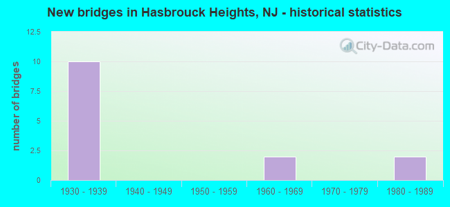
- New bridges - historical statistics
- 101930-1939
- 21960-1969
- 21980-1989


- Bridge Condition - Deck
- 14.3%Good
- 28.6%Satisfactory
- 14.3%Fair
- 28.6%Poor
- 14.3%Serious

- Bridge Condition - Superstructure
- 14.3%Good
- 28.6%Satisfactory
- 57.1%Fair

- Bridge Condition - Substructure
- 28.6%Satisfactory
- 42.9%Fair
- 28.6%Poor
Find on map >> Show street view
Structure Number: 21315, Location: US 46 INTERCHANGE (Lat: 40.866119, Lng: -74.063461), Route carried "on" structure: Ramp US 46, Year Built: 1964, Status: Open, Structure Length: 3.66m (12.01ft), Average Daily Traffic: 7,880 (year 2021), Truck Traffic: 4%, Average Future Daily Traffic: 9,460 (year 2041), Design Load: HS 20, Features Intersected: NJ 17 NB
Minimum Vertical Clearance: 30+ m (98+ ft), Kilometerpoint: 109.612, Lanes on structure: 1, Lanes under structure: 3, Owner: State Highway Agency, Approaching Roadway Width: 8.2m (26.9ft), Skew: 4 degrees, Material/Design: Steel, Design/Construction: Stringer/Multi-beam, Number Of Spans In Main Unit: 1, Length of Maximum Span: 33.5m (109.9ft), Curb or Sidewalk Widths: Left: 0.5m (1.6ft), Right: 1.8m (5.9ft), Curb-To-Curb Width: 8.2m (26.9ft), Out-to-Out Width: 10.9m (35.8ft)
Condition: Deck: Poor, Superstructure: Satisfactory, Substructure: Satisfactory, Operating Rating: 67.1 metric tons, Method Used To Determine Operating Rating: Load Factor (LF), Inventory Rating: 39.9 metric tons, Method Used To Determine Inventory Rating: Load Factor (LF), Structural Evaluation: Equal to present minimum criteria, Deck Geometry: Superior to present desirable criteria, Underclear: High priority of corrective action, Approach Roadway Alignment: Equal to present minimum criteria, Length Of Structure Improvement: 3.66m (12.01ft), Designated Inspection Frequency: Every 24 months, Inspection Date: August 2021, Bridge Improvement Cost: $929,000, Roadway Improvement Cost: $74,000, Total Project Cost: $1,154,000 ( Estimate for 2021), Deck Structure Type: Concrete Cast-file-Place
Find on map >> Show street view
Structure Number: 213151, Location: 0.3 MI N OF RTS 17&46 JCT (Lat: 40.870650, Lng: -74.063581), Route carried "on" structure: County highway 55, Year Built: 1988, Status: Open, Structure Length: 7.62m (25.00ft), Average Daily Traffic: 21,400 (year 2020), Truck Traffic: 4%, Average Future Daily Traffic: 25,700 (year 2040), Design Load: HS 20+Mod, Features Intersected: NJ 17
Minimum Vertical Clearance: 30+ m (98+ ft), Kilometerpoint: 5.955, Lanes on structure: 3, Lanes under structure: 5, Owner: State Highway Agency, Approaching Roadway Width: 13.4m (44.0ft), Skew: 5 degrees, Material/Design: Steel continuous, Design/Construction: Stringer/Multi-beam, Number Of Spans In Main Unit: 2, Length of Maximum Span: 43.6m (143.0ft), Curb or Sidewalk Widths: Left: 1.8m (5.9ft), Right: 1.8m (5.9ft), Curb-To-Curb Width: 13.4m (44.0ft), Out-to-Out Width: 17.7m (58.1ft)
Condition: Deck: Good, Superstructure: Good, Substructure: Satisfactory, Inventory Rating: 64.4 metric tons, Method Used To Determine Inventory Rating: Load Factor (LF), Structural Evaluation: Equal to present minimum criteria, Deck Geometry: Somewhat better than minimum adequacy, Underclear: Somewhat better than minimum adequacy, Approach Roadway Alignment: Better than present minimum criteria, Designated Inspection Frequency: Every 24 months, Inspection Date: June 2020, Deck Structure Type: Concrete Cast-file-Place, Wearing Surface/Protective System: Deck Protection: Epoxy Coated Reinforcing
Find on map >> Show street view
Structure Number: 220161, Location: 0.39 MILES W. OF NJ 17 (Lat: 40.872419, Lng: -74.068200), Route carried "on" structure: US 46, Year Built: 1936, Status: Open, Structure Length: 2.59m (8.50ft), Average Daily Traffic: 39,900 (year 2021), Truck Traffic: 4%, Average Future Daily Traffic: 47,900 (year 2041), Features Intersected: VALLEY BOULEVARD (CR 57)
Minimum Vertical Clearance: 30+ m (98+ ft), Kilometerpoint: 108.824, Lanes on structure: 4, Lanes under structure: 2, Base Highway Network: Yes, Owner: State Highway Agency, Approaching Roadway Width: 20.7m (67.9ft), Skew: 32 degrees, Material/Design: Steel, Design/Construction: Stringer/Multi-beam, Number Of Spans In Main Unit: 1, Number Of Approach Spans: 2, Length of Maximum Span: 18.6m (61.0ft), Curb or Sidewalk Widths: Left: 1.9m (6.2ft), Right: 1.9m (6.2ft), Curb-To-Curb Width: 20.7m (67.9ft), Out-to-Out Width: 25.8m (84.6ft)
Condition: Deck: Fair, Superstructure: Satisfactory, Substructure: Fair, Operating Rating: 49.0 metric tons, Method Used To Determine Operating Rating: Load Factor (LF), Inventory Rating: 29.0 metric tons, Method Used To Determine Inventory Rating: Load Factor (LF), Structural Evaluation: Somewhat better than minimum adequacy, Deck Geometry: Superior to present desirable criteria, Underclear: Meets minimum limits, Approach Roadway Alignment: Better than present minimum criteria, Designated Inspection Frequency: Every 24 months, Inspection Date: September 2021, Roadway Improvement Cost: $100,000, Total Project Cost: $125,000 ( Estimate for 2017), Deck Structure Type: Concrete Cast-file-Place, Wearing Surface/Protective System: Wearing Surface: Bituminous, Membrane: Other
Find on map >> Show street view
Structure Number: 22115, Location: 0.10 MILE W. of NJ 17 Jct (Lat: 40.868831, Lng: -74.065319), Route carried "on" structure: US 46, Year Built: 1936, Status: Open, Structure Length: 1.74m (5.71ft), Average Daily Traffic: 39,860 (year 2021), Truck Traffic: 4%, Average Future Daily Traffic: 47,830 (year 2041), Features Intersected: TERRACE AVENUE (CR. 55)
Minimum Vertical Clearance: 30+ m (98+ ft), Kilometerpoint: 109.291, Lanes on structure: 4, Lanes under structure: 2, Base Highway Network: Yes, Owner: State Highway Agency, Approaching Roadway Width: 14.6m (47.9ft), Skew: 32 degrees, Material/Design: Steel, Design/Construction: Stringer/Multi-beam, Number Of Spans In Main Unit: 1, Length of Maximum Span: 16.2m (53.1ft), Curb or Sidewalk Widths: Left: 1.8m (5.9ft), Right: 1.8m (5.9ft), Curb-To-Curb Width: 14.6m (47.9ft), Out-to-Out Width: 19.8m (65.0ft)
Condition: Deck: Satisfactory, Superstructure: Fair, Substructure: Fair, Operating Rating: 46.3 metric tons, Method Used To Determine Operating Rating: Load Factor (LF), Inventory Rating: 27.2 metric tons, Method Used To Determine Inventory Rating: Load Factor (LF), Structural Evaluation: Somewhat better than minimum adequacy, Deck Geometry: High priority of replacement, Underclear: Somewhat better than minimum adequacy, Approach Roadway Alignment: Equal to present desirable criteria, Length Of Structure Improvement: 2.44m (8.01ft), Designated Inspection Frequency: Every 24 months, Inspection Date: August 2021, Bridge Improvement Cost: $2,227,000, Roadway Improvement Cost: $50,000, Total Project Cost: $3,165,000 ( Estimate for 2021), Deck Structure Type: Concrete Cast-file-Place, Wearing Surface/Protective System: Wearing Surface: Bituminous
Find on map >> Show street view
Structure Number: 221151, Location: JCT OF 46 & NJ 17 SB (Lat: 40.867611, Lng: -74.064231), Route carried "on" structure: US 46, Year Built: 1936, Status: Open, Structure Length: 2.50m (8.20ft), Average Daily Traffic: 35,981 (year 2021), Truck Traffic: 4%, Average Future Daily Traffic: 43,177 (year 2041), Design Load: HS 20, Features Intersected: RT NJ 17 SOUTHBOUND
Minimum Vertical Clearance: 30+ m (98+ ft), Kilometerpoint: 109.451, Lanes on structure: 4, Lanes under structure: 2, Base Highway Network: Yes, Owner: State Highway Agency, Approaching Roadway Width: 15.2m (49.9ft), Skew: 34 degrees, Material/Design: Steel, Design/Construction: Stringer/Multi-beam, Number Of Spans In Main Unit: 1, Number Of Approach Spans: 2, Length of Maximum Span: 16.8m (55.1ft), Curb or Sidewalk Widths: Left: 1.9m (6.2ft), Right: 1.6m (5.2ft), Curb-To-Curb Width: 14.6m (47.9ft), Out-to-Out Width: 19.7m (64.6ft)
Condition: Deck: Poor, Superstructure: Fair, Substructure: Poor, Operating Rating: 30.8 metric tons, Method Used To Determine Operating Rating: Load Factor (LF), Inventory Rating: 18.1 metric tons, Method Used To Determine Inventory Rating: Load Factor (LF), Structural Evaluation: Meets minimum limits, Deck Geometry: High priority of replacement, Underclear: High priority of replacement, Approach Roadway Alignment: Equal to present desirable criteria, Length Of Structure Improvement: 3.35m (10.99ft), Designated Inspection Frequency: Every 24 months, Inspection Date: March 2021, Bridge Improvement Cost: $5,056,000, Roadway Improvement Cost: $1,087,000, Total Project Cost: $10,360,000 ( Estimate for 2021), Deck Structure Type: Concrete Cast-file-Place, Wearing Surface/Protective System: Wearing Surface: Bituminous, Membrane: Other
Find on map >> Show street view
Structure Number: 221152, Location: 3.7 MILES EAST OF GSP (Lat: 40.866339, Lng: -74.063381), Route carried "on" structure: US 46, Year Built: 1936, Year Reconstructed: 1963, Status: Open, Structure Length: 2.50m (8.20ft), Average Daily Traffic: 49,866 (year 2021), Truck Traffic: 4%, Average Future Daily Traffic: 60,846 (year 2041), Features Intersected: NJ 17 NORTHBOUND
Minimum Vertical Clearance: 30+ m (98+ ft), Kilometerpoint: 109.612, Lanes on structure: 4, Lanes under structure: 3, Base Highway Network: Yes, Owner: State Highway Agency, Approaching Roadway Width: 15.8m (51.8ft), Skew: 35 degrees, Material/Design: Steel, Design/Construction: Girder and Floorbeam System, Number Of Spans In Main Unit: 1, Length of Maximum Span: 24.1m (79.1ft), Curb or Sidewalk Widths: Left: 1.3m (4.3ft), Right: 1.3m (4.3ft), Curb-To-Curb Width: 15.8m (51.8ft), Out-to-Out Width: 19.8m (65.0ft)
Condition: Deck: Serious, Superstructure: Fair, Substructure: Poor, Operating Rating: 73.5 metric tons, Method Used To Determine Operating Rating: Load Factor (LF), Inventory Rating: 43.5 metric tons, Method Used To Determine Inventory Rating: Load Factor (LF), Structural Evaluation: Meets minimum limits, Deck Geometry: Meets minimum limits, Underclear: High priority of replacement, Approach Roadway Alignment: Equal to present desirable criteria, Length Of Structure Improvement: 3.26m (10.70ft), Designated Inspection Frequency: Every 24 months, Critical Feature Inspection Frequency: Every 24 months, Other Special Inspection Frequency: Every 12 months, Inspection Date: June 2021, Critical Feature Inspection Date: June 2021, Other Special Inspection Date: June 2021, Bridge Improvement Cost: $3,000, Total Project Cost: $4,000 ( Estimate for 2021), Deck Structure Type: Concrete Cast-file-Place, Wearing Surface/Protective System: Wearing Surface: Monolithic Concrete
Find on map >> Show street view
Structure Number: 221153, Location: 0.1 MILE EAST OF RT 17 (Lat: 40.865350, Lng: -74.062639), Route carried "on" structure: US 46, Year Built: 1934, Year Reconstructed: 1962, Status: Open, Structure Length: 7.25m (23.79ft), Average Daily Traffic: 35,981 (year 2021), Truck Traffic: 4%, Average Future Daily Traffic: 43,177 (year 2041), Design Load: H 20, Features Intersected: NJ TRANSIT & GREEN ST
Minimum Vertical Clearance: 30+ m (98+ ft), Kilometerpoint: 109.773, Lanes on structure: 6, Lanes under structure: 2, Base Highway Network: Yes, Owner: State Highway Agency, Approaching Roadway Width: 23.8m (78.1ft), Skew: 32 degrees, Material/Design: Steel, Design/Construction: Stringer/Multi-beam, Number Of Spans In Main Unit: 4, Length of Maximum Span: 21.6m (70.9ft), Curb or Sidewalk Widths: Left: 1.8m (5.9ft), Right: 1.8m (5.9ft), Curb-To-Curb Width: 23.2m (76.1ft), Out-to-Out Width: 28.2m (92.5ft)
Condition: Deck: Satisfactory, Superstructure: Fair, Substructure: Fair, Operating Rating: 61.7 metric tons, Method Used To Determine Operating Rating: Load Factor (LF), Inventory Rating: 37.2 metric tons, Method Used To Determine Inventory Rating: Load Factor (LF), Structural Evaluation: Somewhat better than minimum adequacy, Deck Geometry: Meets minimum limits, Underclear: Meets minimum limits, Approach Roadway Alignment: Equal to present desirable criteria, Designated Inspection Frequency: Every 24 months, Inspection Date: March 2021, Deck Structure Type: Concrete Cast-file-Place, Wearing Surface/Protective System: Wearing Surface: Bituminous
Find on map >> Show street view
Structure Number: 21315, Location: US 46 INTERCHANGE (Lat: 40.866119, Lng: -74.063461), Route carried "under" structure: State highway 17, Year Built: 1964, Structure Length: 0. m, Average Daily Traffic: 45,900 (year 2019), Truck Traffic: 4%, Features Intersected: NJ 17 NB, Facility Carried by Structure: US 46 EB RAMP A
Minimum Vertical Clearance: 5.08m (16.67ft), Kilometerpoint: 13.551, Lanes on structure: 1, Lanes under structure: 3, Material/Design: Steel, Design/Construction: Stringer/Multi-beam, Length of Maximum Span: 33.5m (109.9ft)
Find on map >> Show street view
Structure Number: 213151, Location: 0.3 MI N OF RTS 17&46 JCT (Lat: 40.870650, Lng: -74.063581), Route carried "under" structure: State highway 17, Year Built: 1988, Structure Length: 0. m, Average Daily Traffic: 77,900 (year 2020), Truck Traffic: 4%, Features Intersected: NJ 17, Facility Carried by Structure: TERRACE AVE(CR 55)
Minimum Vertical Clearance: 6.10m (20.01ft), Kilometerpoint: 14.098, Lanes on structure: 3, Lanes under structure: 5, Material/Design: Steel continuous, Design/Construction: Stringer/Multi-beam, Length of Maximum Span: 43.6m (143.0ft)
Find on map >> Show street view
Structure Number: 220161, Location: 0.39 MILES W. OF NJ 17 (Lat: 40.872419, Lng: -74.068200), Route carried "under" structure: County highway , Year Built: 1936, Structure Length: 0. m, Average Daily Traffic: 19,300 (year 2021), Truck Traffic: 4%, Features Intersected: VALLEY BOULEVARD (CR 57), Facility Carried by Structure: US 46
Minimum Vertical Clearance: 4.47m (14.67ft), Kilometerpoint: 3.074, Lanes on structure: 4, Lanes under structure: 2, Material/Design: Steel, Design/Construction: Stringer/Multi-beam, Length of Maximum Span: 18.6m (61.0ft)
Find on map >> Show street view
Structure Number: 22115, Location: 0.10 MILE W. of NJ 17 Jct (Lat: 40.868831, Lng: -74.065319), Route carried "under" structure: County highway 55, Year Built: 1936, Structure Length: 0. m, Average Daily Traffic: 21,560 (year 2021), Truck Traffic: 4%, Features Intersected: TERRACE AVENUE (CR. 55), Facility Carried by Structure: US 46
Minimum Vertical Clearance: 4.85m (15.91ft), Kilometerpoint: 5.665, Lanes on structure: 4, Lanes under structure: 2, Material/Design: Steel, Design/Construction: Stringer/Multi-beam, Length of Maximum Span: 16.2m (53.1ft)
Find on map >> Show street view
Structure Number: 221151, Location: JCT OF 46 & NJ 17 SB (Lat: 40.867611, Lng: -74.064231), Route carried "under" structure: State highway 17, Year Built: 1936, Structure Length: 0. m, Average Daily Traffic: 40,758 (year 2021), Truck Traffic: 4%, Features Intersected: RT NJ 17 SOUTHBOUND, Facility Carried by Structure: US ROUTE 46
Minimum Vertical Clearance: 4.50m (14.76ft), Kilometerpoint: 13.583, Lanes on structure: 4, Lanes under structure: 2, Material/Design: Steel, Design/Construction: Stringer/Multi-beam, Length of Maximum Span: 16.8m (55.1ft)
Find on map >> Show street view
Structure Number: 221152, Location: 3.7 MILES EAST OF GSP (Lat: 40.866339, Lng: -74.063381), Route carried "under" structure: State highway 17, Year Built: 1936, Structure Length: 0. m, Average Daily Traffic: 46,597 (year 2021), Truck Traffic: 4%, Features Intersected: NJ 17 NORTHBOUND, Facility Carried by Structure: US 46
Minimum Vertical Clearance: 4.42m (14.50ft), Kilometerpoint: 13.583, Lanes on structure: 4, Lanes under structure: 3, Material/Design: Steel, Design/Construction: Girder and Floorbeam System, Length of Maximum Span: 24.1m (79.1ft)
Find on map >> Show street view
Structure Number: 221153, Location: 0.1 MILE EAST OF RT 17 (Lat: 40.865350, Lng: -74.062639), Route carried "under" structure: City street , Year Built: 1934, Structure Length: 0. m, Average Daily Traffic: 2,601 (year 2021), Truck Traffic: 4%, Features Intersected: NJ TRANSIT & GREEN ST, Facility Carried by Structure: RT US 46
Minimum Vertical Clearance: 7.80m (25.59ft), Kilometerpoint: 0.002, Lanes on structure: 6, Lanes under structure: 2, Material/Design: Steel, Design/Construction: Stringer/Multi-beam, Length of Maximum Span: 21.6m (70.9ft)