Bridge Statistics for Havre de Grace, Maryland (MD)
Condition, Traffic, Stress, Structural Evaluation, Project Costs
- National Bridge Inventory (NBI) Statistics
- 10Number of bridges
- 1,444ft / 440mTotal length
- $3,135,000Total costs
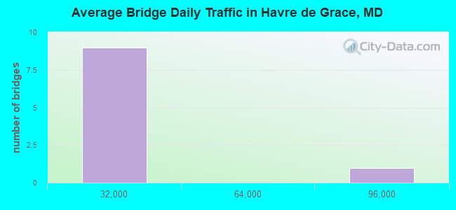
- 151,968Total average daily traffic
- 12,827Total average daily truck traffic
- 202,826Total future (year 2038) average daily traffic
- National Bridge Inventory (NBI) Registered Bridges for Havre de Grace
- No street view available for this location
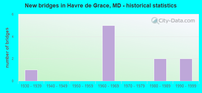
- New bridges - historical statistics
- 11930-1939
- 51960-1969
- 21980-1989
- 21990-1999
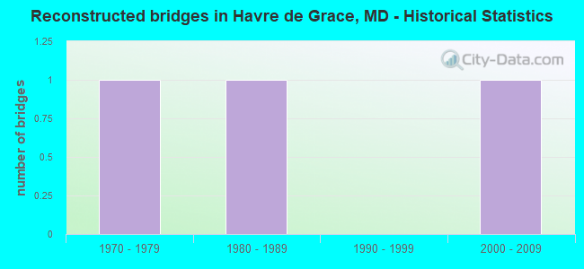
- Reconstructed bridges - Historical Statistics
- 11970-1979
- 11980-1989
- 01990-1999
- 12000-2009
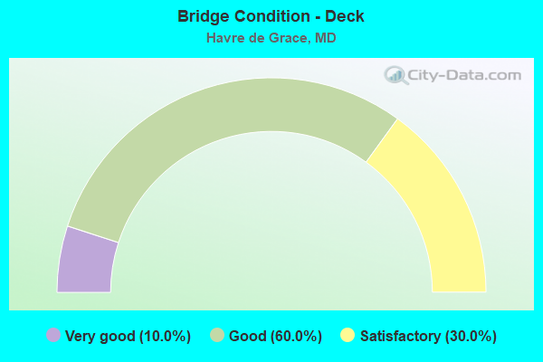
- Bridge Condition - Deck
- 10.0%Very good
- 60.0%Good
- 30.0%Satisfactory
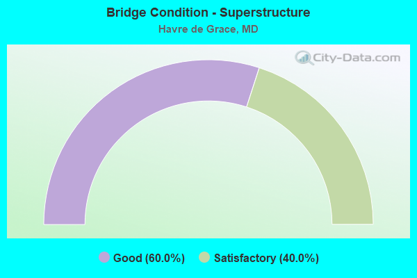
- Bridge Condition - Superstructure
- 60.0%Good
- 40.0%Satisfactory
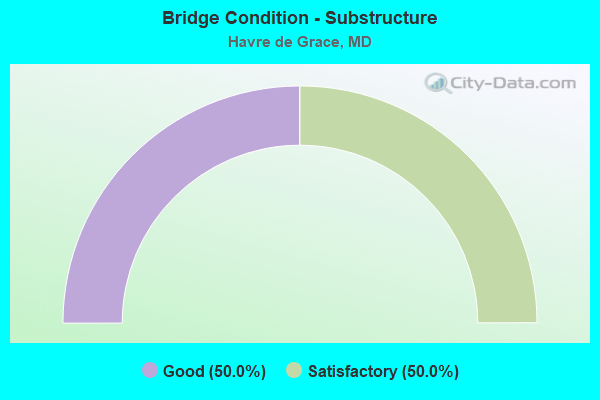
- Bridge Condition - Substructure
- 50.0%Good
- 50.0%Satisfactory
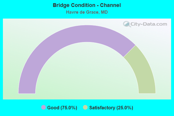
- Bridge Condition - Channel
- 75.0%Good
- 25.0%Satisfactory
Find on map >> Show street view
Structure Number: 10000012007301, Location: 0.12 MILE NORTH OF US 40 (Lat: 39.535819, Lng: -76.114531), Route carried "on" structure: State highway 7A, Year Built: 1983, Status: Open, Structure Length: 16.67m (54.69ft), Average Daily Traffic: 11,240 (year 2018), Truck Traffic: 8%, Average Future Daily Traffic: 16,705 (year 2038), Design Load: HS 20, Features Intersected: AMTRAK
Minimum Vertical Clearance: 5.49m (18.01ft), Kilometerpoint: 0.193, Lanes on structure: 2, Owner: State Highway Agency, Approaching Roadway Width: 13.4m (44.0ft), Material/Design: Steel, Design/Construction: Stringer/Multi-beam, Number Of Spans In Main Unit: 4, Length of Maximum Span: 52.4m (171.9ft), Curb or Sidewalk Widths: Left: 1.6m (5.2ft), Right: 1.6m (5.2ft), Curb-To-Curb Width: 13.4m (44.0ft), Out-to-Out Width: 17.1m (56.1ft)
Condition: Deck: Good, Superstructure: Good, Substructure: Satisfactory, Inventory Rating: 60.8 metric tons, Method Used To Determine Inventory Rating: Load Factor (LF), Structural Evaluation: Equal to present minimum criteria, Deck Geometry: Equal to present minimum criteria, Underclear: Meets minimum limits, Approach Roadway Alignment: Equal to present desirable criteria, Length Of Structure Improvement: 16.67m (54.69ft), Designated Inspection Frequency: Every 24 months, Critical Feature Inspection Frequency: Every 24 months, Inspection Date: December 2021, Critical Feature Inspection Date: December 2021, Bridge Improvement Cost: $1,841,000, Roadway Improvement Cost: $184,000, Total Project Cost: $2,025,000, Deck Structure Type: Concrete Cast-file-Place, Wearing Surface/Protective System: Wearing Surface: Monolithic Concrete
Find on map >> Show street view
Structure Number: 200000H-002001, Location: 0.7 MI SE OF ROCK RUN RD (Lat: 39.590719, Lng: -76.158011), Route carried "on" structure: County highway 382, Year Built: 1997, Status: Open, Structure Length: 0.79m (2.59ft), Average Daily Traffic: 200 (year 2019), Truck Traffic: 5%, Average Future Daily Traffic: 245 (year 2039), Design Load: HS 20, Features Intersected: ROCK RUN, Facility Carried by Structure: COOLEY MILL ROAD
Minimum Vertical Clearance: 30+ m (98+ ft), Kilometerpoint: 1.094, Lanes on structure: 1, Owner: County Highway Agency, Approaching Roadway Width: 4.9m (16.1ft), Material/Design: Prestressed concrete, Design/Construction: Box Beam or Girders - Multiple, Number Of Spans In Main Unit: 1, Length of Maximum Span: 7.6m (24.9ft), Curb-To-Curb Width: 4.7m (15.4ft), Out-to-Out Width: 4.9m (16.1ft)
Condition: Deck: Very good, Superstructure: Good, Substructure: Good, Channel: Good, Operating Rating: 82.5 metric tons, Method Used To Determine Operating Rating: Load Factor (LF), Inventory Rating: 49.4 metric tons, Method Used To Determine Inventory Rating: Load Factor (LF), Structural Evaluation: Better than present minimum criteria, Deck Geometry: High priority of replacement, Waterway Adequacy: Better than present minimum criteria, Approach Roadway Alignment: Meets minimum limits, Designated Inspection Frequency: Every 24 months, Inspection Date: July 2021, Wearing Surface/Protective System: Wearing Surface: Bituminous
Find on map >> Show street view
Structure Number: 200000H-016401, Location: 0.8 MILES S OF MD 132 (Lat: 39.519106, Lng: -76.126072), Route carried "on" structure: County highway 1064, Year Built: 1993, Status: Open, Structure Length: 1.49m (4.89ft), Average Daily Traffic: 1,330 (year 2019), Truck Traffic: 5%, Average Future Daily Traffic: 1,625 (year 2039), Design Load: HS 20, Features Intersected: GASHEYS CREEK, Facility Carried by Structure: OAKINGTON ROAD
Minimum Vertical Clearance: 30+ m (98+ ft), Kilometerpoint: 1.335, Lanes on structure: 2, Owner: County Highway Agency, Approaching Roadway Width: 9.1m (29.9ft), Skew: 1 degrees, Material/Design: Steel, Design/Construction: Stringer/Multi-beam, Number Of Spans In Main Unit: 1, Length of Maximum Span: 13.7m (44.9ft), Curb-To-Curb Width: 9.1m (29.9ft), Out-to-Out Width: 10.1m (33.1ft)
Condition: Deck: Good, Superstructure: Good, Substructure: Good, Channel: Satisfactory, Inventory Rating: 67.6 metric tons, Method Used To Determine Inventory Rating: Load Factor (LF), Structural Evaluation: Better than present minimum criteria, Deck Geometry: Somewhat better than minimum adequacy, Waterway Adequacy: Equal to present desirable criteria, Approach Roadway Alignment: Better than present minimum criteria, Designated Inspection Frequency: Every 24 months, Inspection Date: November 2021, Deck Structure Type: Concrete Cast-file-Place, Wearing Surface/Protective System: Wearing Surface: Monolithic Concrete, Deck Protection: Epoxy Coated Reinforcing
Find on map >> Show street view
Structure Number: 200000H-H-0101, Location: 0.1 MILES E OF US 40 (Lat: 39.545283, Lng: -76.105392), Route carried "on" structure: City street MU042, Year Built: 1980, Status: Open, Structure Length: 5.52m (18.11ft), Average Daily Traffic: 5,745 (year 2019), Truck Traffic: 5%, Average Future Daily Traffic: 7,010 (year 2039), Design Load: HS 20, Features Intersected: AMTRAK RAILROAD, Facility Carried by Structure: LEWIS LANE
Minimum Vertical Clearance: 30+ m (98+ ft), Kilometerpoint: 0.000, Lanes on structure: 2, Owner: City or Municipal Highway Agency, Approaching Roadway Width: 12.8m (42.0ft), Skew: 1 degrees, Material/Design: Steel continuous, Design/Construction: Stringer/Multi-beam, Number Of Spans In Main Unit: 3, Length of Maximum Span: 27.4m (89.9ft), Curb or Sidewalk Widths: Left: 1.5m (4.9ft), Right: 1.5m (4.9ft), Curb-To-Curb Width: 12.8m (42.0ft), Out-to-Out Width: 16.5m (54.1ft)
Condition: Deck: Good, Superstructure: Good, Substructure: Satisfactory, Operating Rating: 63.0 metric tons, Method Used To Determine Operating Rating: Load Factor (LF), Inventory Rating: 37.6 metric tons, Method Used To Determine Inventory Rating: Load Factor (LF), Structural Evaluation: Equal to present minimum criteria, Deck Geometry: Somewhat better than minimum adequacy, Underclear: Superior to present desirable criteria, Approach Roadway Alignment: Equal to present minimum criteria, Length Of Structure Improvement: 5.52m (18.11ft), Designated Inspection Frequency: Every 24 months, Inspection Date: October 2021, Bridge Improvement Cost: $586,000, Roadway Improvement Cost: $59,000, Total Project Cost: $645,000, Deck Structure Type: Concrete Cast-file-Place, Wearing Surface/Protective System: Wearing Surface: Monolithic Concrete, Deck Protection: Epoxy Coated Reinforcing
Find on map >> Show street view
Structure Number: 300000H-X87801, Location: Milepost 87.8 (Lat: 39.556039, Lng: -76.154519), Route carried "on" structure: County highway 411, Year Built: 1963, Status: Open, Structure Length: 6.89m (22.60ft), Average Daily Traffic: 2,816 (year 2019), Truck Traffic: 5%, Average Future Daily Traffic: 3,356 (year 2041), Design Load: H 20, Features Intersected: I-95, Facility Carried by Structure: CHAPEL ROAD
Minimum Vertical Clearance: 30+ m (98+ ft), Kilometerpoint: 141.270, Lanes on structure: 2, Lanes under structure: 6, Owner: State Toll Authority, Approaching Roadway Width: 7.9m (25.9ft), Skew: 1 degrees, Material/Design: Steel, Design/Construction: Stringer/Multi-beam, Number Of Spans In Main Unit: 4, Length of Maximum Span: 23.5m (77.1ft), Curb or Sidewalk Widths: Left: 0.5m (1.6ft), Right: 0.5m (1.6ft), Curb-To-Curb Width: 7.9m (25.9ft), Out-to-Out Width: 9.5m (31.2ft)
Condition: Deck: Good, Superstructure: Satisfactory, Substructure: Satisfactory, Operating Rating: 60.8 metric tons, Method Used To Determine Operating Rating: Load Factor (LF), Inventory Rating: 36.3 metric tons, Method Used To Determine Inventory Rating: Load Factor (LF), Structural Evaluation: Equal to present minimum criteria, Deck Geometry: High priority of corrective action, Underclear: Meets minimum limits, Approach Roadway Alignment: Better than present minimum criteria, Length Of Structure Improvement: 6.89m (22.60ft), Designated Inspection Frequency: Every 24 months, Inspection Date: December 2021, Bridge Improvement Cost: $423,000, Roadway Improvement Cost: $42,000, Total Project Cost: $465,000, Deck Structure Type: Concrete Cast-file-Place, Wearing Surface/Protective System: Wearing Surface: Latex Concrete
Find on map >> Show street view
Structure Number: 300000H-X88101, Location: Milepost M88.4 (Lat: 39.562269, Lng: -76.146797), Route carried "on" structure: County highway 1065, Year Built: 1963, Status: Open, Structure Length: 7.22m (23.69ft), Average Daily Traffic: 829 (year 2019), Truck Traffic: 5%, Average Future Daily Traffic: 1,032 (year 2041), Design Load: H 20, Features Intersected: I-95, Facility Carried by Structure: EARLTON ROAD
Minimum Vertical Clearance: 30+ m (98+ ft), Kilometerpoint: 141.753, Lanes on structure: 2, Lanes under structure: 6, Owner: State Toll Authority, Approaching Roadway Width: 7.9m (25.9ft), Skew: 2 degrees, Material/Design: Steel, Design/Construction: Stringer/Multi-beam, Number Of Spans In Main Unit: 4, Length of Maximum Span: 25.3m (83.0ft), Curb or Sidewalk Widths: Left: 0.5m (1.6ft), Right: 0.5m (1.6ft), Curb-To-Curb Width: 7.9m (25.9ft), Out-to-Out Width: 9.5m (31.2ft)
Condition: Deck: Satisfactory, Superstructure: Good, Substructure: Good, Operating Rating: 74.8 metric tons, Method Used To Determine Operating Rating: Load Factor (LF), Inventory Rating: 44.9 metric tons, Method Used To Determine Inventory Rating: Load Factor (LF), Structural Evaluation: Better than present minimum criteria, Deck Geometry: Somewhat better than minimum adequacy, Underclear: Meets minimum limits, Approach Roadway Alignment: Equal to present desirable criteria, Designated Inspection Frequency: Every 24 months, Inspection Date: December 2021, Deck Structure Type: Concrete Cast-file-Place, Wearing Surface/Protective System: Wearing Surface: Latex Concrete
Find on map >> Show street view
Structure Number: 300000H-X89001, Location: Milepost M89.0 (Lat: 39.571447, Lng: -76.138069), Route carried "on" structure: State highway 155, Year Built: 1960, Year Reconstructed: 1983, Status: Open, Structure Length: 7.41m (24.31ft), Average Daily Traffic: 15,420 (year 2019), Truck Traffic: 2%, Average Future Daily Traffic: 18,375 (year 2041), Design Load: HS 20, Features Intersected: I-95
Minimum Vertical Clearance: 30+ m (98+ ft), Kilometerpoint: 143.201, Lanes on structure: 2, Lanes under structure: 6, Owner: State Toll Authority, Approaching Roadway Width: 13.4m (44.0ft), Material/Design: Steel, Design/Construction: Stringer/Multi-beam, Number Of Spans In Main Unit: 4, Length of Maximum Span: 25.6m (84.0ft), Curb-To-Curb Width: 13.5m (44.3ft), Out-to-Out Width: 14.5m (47.6ft)
Condition: Deck: Satisfactory, Superstructure: Satisfactory, Substructure: Good, Operating Rating: 52.2 metric tons, Method Used To Determine Operating Rating: Load Factor (LF), Inventory Rating: 31.3 metric tons, Method Used To Determine Inventory Rating: Load Factor (LF), Structural Evaluation: Equal to present minimum criteria, Deck Geometry: Superior to present desirable criteria, Underclear: Somewhat better than minimum adequacy, Approach Roadway Alignment: Equal to present desirable criteria, Designated Inspection Frequency: Every 24 months, Inspection Date: December 2021, Deck Structure Type: Concrete Cast-file-Place, Wearing Surface/Protective System: Wearing Surface: Monolithic Concrete, Deck Protection: Epoxy Coated Reinforcing
Find on map >> Show street view
Structure Number: 300000H-X89401, Location: Milepost M89.7 (Lat: 39.575119, Lng: -76.130578), Route carried "on" structure: County highway 180, Year Built: 1963, Status: Open, Structure Length: 6.98m (22.90ft), Average Daily Traffic: 515 (year 2019), Average Future Daily Traffic: 641 (year 2041), Design Load: H 20, Features Intersected: I-95, Facility Carried by Structure: LAPIDUM ROAD
Minimum Vertical Clearance: 30+ m (98+ ft), Kilometerpoint: 143.845, Lanes on structure: 2, Lanes under structure: 6, Owner: State Toll Authority, Approaching Roadway Width: 7.9m (25.9ft), Material/Design: Steel, Design/Construction: Stringer/Multi-beam, Number Of Spans In Main Unit: 4, Length of Maximum Span: 23.2m (76.1ft), Curb or Sidewalk Widths: Left: 0.5m (1.6ft), Right: 1.6m (5.2ft), Curb-To-Curb Width: 7.9m (25.9ft), Out-to-Out Width: 10.6m (34.8ft)
Condition: Deck: Good, Superstructure: Good, Substructure: Good, Operating Rating: 68.5 metric tons, Method Used To Determine Operating Rating: Load Factor (LF), Inventory Rating: 40.8 metric tons, Method Used To Determine Inventory Rating: Load Factor (LF), Structural Evaluation: Better than present minimum criteria, Deck Geometry: Somewhat better than minimum adequacy, Underclear: Meets minimum limits, Approach Roadway Alignment: Equal to present desirable criteria, Designated Inspection Frequency: Every 24 months, Inspection Date: December 2021, Deck Structure Type: Concrete Cast-file-Place, Wearing Surface/Protective System: Wearing Surface: Latex Concrete
Find on map >> Show street view
Structure Number: 300000H-X90701, Location: HARFORD-CECIL CO LINE (Lat: 39.577556, Lng: -76.112556), Route carried "on" structure: Interstate 95, Year Built: 1963, Year Reconstructed: 1988, Status: Open, Structure Length: 154.26m (506.10ft), Average Daily Traffic: 84,896 (year 2019), Truck Traffic: 11%, Average Future Daily Traffic: 119,082 (year 2041), Design Load: HS 20, Features Intersected: SUSQUEHANNA RIVER,PA RR
Minimum Vertical Clearance: 30+ m (98+ ft), Kilometerpoint: 145.936, Lanes on structure: 6, Base Highway Network: Yes, Toll: On toll road, Owner: State Toll Authority, Approaching Roadway Width: 30.5m (100.1ft), Skew: 30 degrees, Navigation Control: Yes ( Vertical Clearance: 27.4m (89.9ft), Horizontal Clearance: 144.2m (473.1ft)), Material/Design: Steel continuous, Design/Construction: Truss - Deck, Number Of Spans In Main Unit: 11, Number Of Approach Spans: 3, Length of Maximum Span: 149.4m (490.2ft), Curb-To-Curb Width: 24.4m (80.1ft), Out-to-Out Width: 26.6m (87.3ft)
Condition: Deck: Satisfactory, Superstructure: Satisfactory, Substructure: Satisfactory, Channel: Good, Operating Rating: 54.4 metric tons, Method Used To Determine Operating Rating: Load Factor (LF), Inventory Rating: 32.7 metric tons, Method Used To Determine Inventory Rating: Load Factor (LF), Structural Evaluation: Equal to present minimum criteria, Deck Geometry: Meets minimum limits, Underclear: High priority of corrective action, Waterway Adequacy: Equal to present desirable criteria, Approach Roadway Alignment: Equal to present desirable criteria, Designated Inspection Frequency: Every 24 months, Critical Feature Inspection Frequency: Every 24 months, Underwater Inspection Frequency: Every 60 months, Inspection Date: May 2021, Critical Feature Inspection Date: May 2021, Underwater Inspection Date: March 2018, Deck Structure Type: Concrete Cast-file-Place, Wearing Surface/Protective System: Wearing Surface: Monolithic Concrete, Deck Protection: Epoxy Coated Reinforcing
Find on map >> Show street view
Structure Number: 300000H-Z04001, Location: CECIL-HARFORD COUNTY LINE (Lat: 39.567522, Lng: -76.075053), Route carried "on" structure: US 40, Year Built: 1939, Year Reconstructed: 2011, Status: Open, Structure Length: 232.38m (762.40ft), Average Daily Traffic: 28,977 (year 2019), Truck Traffic: 6%, Average Future Daily Traffic: 34,755 (year 2041), Features Intersected: SUSQUEHANNA RIVER-PA RR
Minimum Vertical Clearance: 4.57m (14.99ft), Kilometerpoint: 0.000, Lanes on structure: 4, Base Highway Network: Yes, Toll: Toll bridge, Owner: State Toll Authority, Approaching Roadway Width: 15.9m (52.2ft), Navigation Control: Yes ( Vertical Clearance: 26.5m (86.9ft), Horizontal Clearance: 97.5m (319.9ft)), Material/Design: Steel, Design/Construction: Truss - Thru, Number Of Spans In Main Unit: 12, Number Of Approach Spans: 44, Length of Maximum Span: 139.0m (456.0ft), Curb-To-Curb Width: 14.4m (47.2ft), Out-to-Out Width: 16.0m (52.5ft)
Condition: Deck: Good, Superstructure: Satisfactory, Substructure: Satisfactory, Channel: Good, Operating Rating: 35.8 metric tons, Method Used To Determine Operating Rating: Load Factor (LF), Inventory Rating: 20.9 metric tons, Method Used To Determine Inventory Rating: Load Factor (LF), Structural Evaluation: Somewhat better than minimum adequacy, Deck Geometry: High priority of replacement, Underclear: Meets minimum limits, Waterway Adequacy: Superior to present desirable criteria, Approach Roadway Alignment: Equal to present desirable criteria, Length Of Structure Improvement: 232.38m (762.40ft), Designated Inspection Frequency: Every 24 months, Critical Feature Inspection Frequency: Every 24 months, Underwater Inspection Frequency: Every 48 months, Inspection Date: May 2021, Critical Feature Inspection Date: May 2021, Underwater Inspection Date: June 2018, Deck Structure Type: Closed Grating, Wearing Surface/Protective System: Wearing Surface: Monolithic Concrete