Bridge Statistics for Hercules, California (CA)
Condition, Traffic, Stress, Structural Evaluation, Project Costs
- National Bridge Inventory (NBI) Statistics
- 27Number of bridges
- 446ft / 136mTotal length
- 908,270Total average daily traffic
- 42,261Total average daily truck traffic
- National Bridge Inventory (NBI) Registered Bridges for Hercules
- No street view available for this location
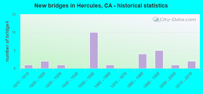
- New bridges - historical statistics
- 11910-1919
- 21920-1929
- 11930-1939
- 101950-1959
- 11960-1969
- 41980-1989
- 51990-1999
- 12000-2009
- 22010-2019

- Reconstructed bridges - Historical Statistics
- 11950-1959
- 11960-1969
- 01970-1979
- 11980-1989
- 01990-1999
- 12000-2009


- Bridge Condition - Deck
- 53.8%Good
- 15.4%Satisfactory
- 23.1%Fair
- 7.7%Poor

- Bridge Condition - Superstructure
- 69.2%Good
- 7.7%Satisfactory
- 23.1%Fair

- Bridge Condition - Substructure
- 76.9%Good
- 23.1%Fair

- Bridge Condition - Channel
- 25.0%Very good
- 75.0%Satisfactory
Find on map >> Show street view
Structure Number: 28 0038R, Location: 04-CC-004-R1.96R (Lat: 38.013889, Lng: -122.238450), Route carried "on" structure: State highway 4, Year Built: 1920, Year Reconstructed: 1969, Status: Open, Structure Length: 2.90m (9.51ft), Average Daily Traffic: 20,250 (year 2018), Truck Traffic: 8%, Average Future Daily Traffic: 40,584 (year 2042), Features Intersected: RODEO CREEK
Minimum Vertical Clearance: 30+ m (98+ ft), Kilometerpoint: 1.960, Lanes on structure: 2, Base Highway Network: Yes (, Subroute: 1), Owner: State Highway Agency, Approaching Roadway Width: 13.4m (44.0ft), Skew: 2 degrees, Material/Design: Concrete continuous, Design/Construction: Tee Beam, Number Of Spans In Main Unit: 3, Length of Maximum Span: 12.8m (42.0ft), Curb-To-Curb Width: 12.2m (40.0ft), Out-to-Out Width: 12.8m (42.0ft)
Condition: Deck: Good, Superstructure: Good, Substructure: Good, Channel: Satisfactory, Operating Rating: 48.3 metric tons, Method Used To Determine Operating Rating: Load Factor (LF), Inventory Rating: 29.2 metric tons, Method Used To Determine Inventory Rating: Load Factor (LF), Structural Evaluation: Better than present minimum criteria, Deck Geometry: Better than present minimum criteria, Waterway Adequacy: Equal to present minimum criteria, Approach Roadway Alignment: Equal to present desirable criteria, Designated Inspection Frequency: Every 24 months, Inspection Date: May 2020, Deck Structure Type: Concrete Cast-file-Place, Wearing Surface/Protective System: Wearing Surface: Bituminous
Find on map >> Show street view
Structure Number: 28 0140L, Location: 04-CC-580-5.83-RCH (Lat: 37.932344, Lng: -122.397981), Route carried "on" structure: Interstate 580, Year Built: 1956, Year Reconstructed: 1988, Status: Open, Structure Length: 19.73m (64.73ft), Average Daily Traffic: 34,000 (year 2009), Truck Traffic: 5%, Average Future Daily Traffic: 59,416 (year 2040), Design Load: HS 20, Features Intersected: SCOFIELD AVENUE
Minimum Vertical Clearance: 30+ m (98+ ft), Kilometerpoint: 5.830, Lanes on structure: 3, Lanes under structure: 2, Base Highway Network: Yes (Inventory Route: 5, Subroute: 1), Owner: State Highway Agency, Approaching Roadway Width: 11.6m (38.1ft), Skew: 9 degrees, Material/Design: Steel continuous, Design/Construction: Stringer/Multi-beam, Number Of Spans In Main Unit: 11, Length of Maximum Span: 21.3m (69.9ft), Curb-To-Curb Width: 14.1m (46.3ft), Out-to-Out Width: 15.4m (50.5ft)
Condition: Deck: Good, Superstructure: Fair, Substructure: Fair, Operating Rating: 38.6 metric tons, Method Used To Determine Operating Rating: Load and Resistance Factor Rating (LRFR) rating reported by rating factor(RF) method using HL-93 loadings, Inventory Rating: 29.5 metric tons, Method Used To Determine Inventory Rating: Load and Resistance Factor Rating (LRFR) rating reported by rating factor(RF) method using HL-93 loadings, Structural Evaluation: Somewhat better than minimum adequacy, Deck Geometry: Meets minimum limits, Underclear: High priority of corrective action, Approach Roadway Alignment: Equal to present minimum criteria, Designated Inspection Frequency: Every 24 months, Critical Feature Inspection Frequency: Every 24 months, Other Special Inspection Frequency: Every 48 months, Inspection Date: March 2020, Critical Feature Inspection Date: October 2020, Other Special Inspection Date: October 2020, Deck Structure Type: Concrete Cast-file-Place
Find on map >> Show street view
Structure Number: 28 0143, Location: 04-CC-080-9.72-HER (Lat: 38.010753, Lng: -122.272983), Route carried "on" structure: Interstate 80, Year Built: 1998, Status: Open, Structure Length: 21.94m (71.98ft), Average Daily Traffic: 179,000 (year 2019), Truck Traffic: 5%, Average Future Daily Traffic: 238,954 (year 2039), Design Load: HS 20+Mod, Features Intersected: BNSF,SYCAMORE,WILLOW
Minimum Vertical Clearance: 30+ m (98+ ft), Kilometerpoint: 9.720, Lanes on structure: 10, Lanes under structure: 7, Base Highway Network: Yes (, Subroute: 1), Owner: State Highway Agency, Approaching Roadway Width: 41.7m (136.8ft), Skew: 39 degrees, Material/Design: Prestressed concrete continuous, Design/Construction: Box Beam or Girders - Multiple, Number Of Spans In Main Unit: 7, Length of Maximum Span: 59.2m (194.2ft), Curb-To-Curb Width: 44.6m (146.3ft), Out-to-Out Width: 46.2m (151.6ft)
Condition: Deck: Satisfactory, Superstructure: Good, Substructure: Good, Operating Rating: 54.1 metric tons, Method Used To Determine Operating Rating: Assigned rating based on Load Factor Design (LFD) reported in metric tons, Inventory Rating: 32.4 metric tons, Method Used To Determine Inventory Rating: Assigned rating based on Load Factor Design (LFD) reported in metric tons, Structural Evaluation: Better than present minimum criteria, Deck Geometry: Superior to present desirable criteria, Underclear: Meets minimum limits, Approach Roadway Alignment: Equal to present desirable criteria, Designated Inspection Frequency: Every 24 months, Inspection Date: July 2021, Deck Structure Type: Concrete Cast-file-Place
Find on map >> Show street view
Structure Number: 28 0143F, Location: 04-CC-004-0.01-HER (Lat: 38.012803, Lng: -122.272144), Route carried "on" structure: Ramp State highway 4, Year Built: 1983, Status: Open, Structure Length: 17.88m (58.66ft), Average Daily Traffic: 20,700 (year 2018), Truck Traffic: 9%, Average Future Daily Traffic: 42,752 (year 2042), Design Load: HS 20+Mod, Features Intersected: BNSF, WILLOW, SYCAMORE
Minimum Vertical Clearance: 30+ m (98+ ft), Kilometerpoint: 0.010, Lanes on structure: 2, Lanes under structure: 10, Owner: State Highway Agency, Approaching Roadway Width: 11.6m (38.1ft), Material/Design: Prestressed concrete continuous, Design/Construction: Box Beam or Girders - Multiple, Number Of Spans In Main Unit: 4, Length of Maximum Span: 53.3m (174.9ft), Curb-To-Curb Width: 11.6m (38.1ft), Out-to-Out Width: 12.7m (41.7ft)
Condition: Deck: Good, Superstructure: Good, Substructure: Good, Operating Rating: 54.1 metric tons, Method Used To Determine Operating Rating: Assigned rating based on Load Factor Design (LFD) reported in metric tons, Inventory Rating: 32.4 metric tons, Method Used To Determine Inventory Rating: Assigned rating based on Load Factor Design (LFD) reported in metric tons, Structural Evaluation: Better than present minimum criteria, Deck Geometry: Superior to present desirable criteria, Underclear: Meets minimum limits, Approach Roadway Alignment: Equal to present desirable criteria, Designated Inspection Frequency: Every 24 months, Inspection Date: May 2020, Deck Structure Type: Concrete Cast-file-Place
Find on map >> Show street view
Structure Number: 28 0148, Location: 04-CC-080-10.02-HER (Lat: 38.014667, Lng: -122.269478), Route carried "on" structure: Interstate 80, Year Built: 1958, Status: Open, Structure Length: 13.53m (44.39ft), Average Daily Traffic: 179,000 (year 2019), Truck Traffic: 5%, Average Future Daily Traffic: 238,954 (year 2039), Design Load: HS 20, Features Intersected: STATE ROUTE 4 & RAMPS
Minimum Vertical Clearance: 30+ m (98+ ft), Kilometerpoint: 10.020, Lanes on structure: 8, Lanes under structure: 4, Base Highway Network: Yes (, Subroute: 1), Owner: State Highway Agency, Approaching Roadway Width: 33.5m (109.9ft), Skew: 30 degrees, Material/Design: Concrete continuous, Design/Construction: Box Beam or Girders - Multiple, Number Of Spans In Main Unit: 4, Number Of Approach Spans: 1, Length of Maximum Span: 35.1m (115.2ft), Curb-To-Curb Width: 33.5m (109.9ft), Out-to-Out Width: 35.8m (117.5ft)
Condition: Deck: Fair, Superstructure: Good, Substructure: Good, Operating Rating: 73.9 metric tons, Method Used To Determine Operating Rating: Load Factor (LF), Inventory Rating: 44.4 metric tons, Method Used To Determine Inventory Rating: Load Factor (LF), Structural Evaluation: Better than present minimum criteria, Deck Geometry: Meets minimum limits, Underclear: Equal to present minimum criteria, Approach Roadway Alignment: Equal to present desirable criteria, Length Of Structure Improvement: 13.53m (44.39ft), Designated Inspection Frequency: Every 24 months, Inspection Date: July 2021, Deck Structure Type: Concrete Cast-file-Place
Find on map >> Show street view
Structure Number: 28 0151S, Location: 04-CC-080-10.69-HER (Lat: 38.022261, Lng: -122.262389), Route carried "on" structure: Ramp Interstate 80, Year Built: 2010, Status: Open, Structure Length: 9.88m (32.41ft), Average Daily Traffic: 5,500 (year 2019), Truck Traffic: 2%, Average Future Daily Traffic: 6,765 (year 2041), Design Load: HL 93, Features Intersected: WILLOW AVENUE
Minimum Vertical Clearance: 30+ m (98+ ft), Kilometerpoint: 10.690, Lanes on structure: 1, Lanes under structure: 4, Owner: State Highway Agency, Approaching Roadway Width: 8.1m (26.6ft), Skew: 1 degrees, Material/Design: Prestressed concrete continuous, Design/Construction: Slab, Number Of Spans In Main Unit: 6, Length of Maximum Span: 23.0m (75.5ft), Curb-To-Curb Width: 8.1m (26.6ft), Out-to-Out Width: 9.0m (29.5ft)
Condition: Deck: Fair, Superstructure: Fair, Substructure: Good, Operating Rating: 42.1 metric tons, Method Used To Determine Operating Rating: Assigned ratings based on Load and Resistance Factor Design (LRFD) reported by rating factor (RF) using HL93 loadings, Inventory Rating: 32.4 metric tons, Method Used To Determine Inventory Rating: Assigned ratings based on Load and Resistance Factor Design (LRFD) reported by rating factor (RF) using HL93 loadings, Structural Evaluation: Somewhat better than minimum adequacy, Deck Geometry: Superior to present desirable criteria, Underclear: Somewhat better than minimum adequacy, Approach Roadway Alignment: Equal to present desirable criteria, Designated Inspection Frequency: Every 24 months, Inspection Date: July 2021, Deck Structure Type: Concrete Cast-file-Place
Find on map >> Show street view
Structure Number: 28 018, Location: 04-CC-680-20.89 (Lat: 37.991022, Lng: -122.067394), Route carried "on" structure: Interstate 680, Year Built: 1962, Year Reconstructed: 2005, Status: Open, Structure Length: 9.96m (32.68ft), Average Daily Traffic: 130,000 (year 2009), Truck Traffic: 3%, Average Future Daily Traffic: 225,763 (year 2036), Design Load: HS 20+Mod, Features Intersected: GRAYSON CREEK
Minimum Vertical Clearance: 30+ m (98+ ft), Kilometerpoint: 20.890, Lanes on structure: 10, Base Highway Network: Yes (Inventory Route: 6, Subroute: 1), Owner: State Highway Agency, Approaching Roadway Width: 45.4m (149.0ft), Skew: 35 degrees, Material/Design: Concrete continuous, Design/Construction: Tee Beam, Number Of Spans In Main Unit: 8, Length of Maximum Span: 12.8m (42.0ft), Curb-To-Curb Width: 45.4m (149.0ft), Out-to-Out Width: 51.8m (169.9ft)
Condition: Deck: Good, Superstructure: Good, Substructure: Good, Channel: Satisfactory, Operating Rating: 54.1 metric tons, Method Used To Determine Operating Rating: Assigned rating based on Load Factor Design (LFD) reported in metric tons, Inventory Rating: 32.4 metric tons, Method Used To Determine Inventory Rating: Assigned rating based on Load Factor Design (LFD) reported in metric tons, Structural Evaluation: Better than present minimum criteria, Deck Geometry: Superior to present desirable criteria, Waterway Adequacy: Meets minimum limits, Approach Roadway Alignment: Equal to present desirable criteria, Designated Inspection Frequency: Every 48 months, Inspection Date: January 2019, Deck Structure Type: Concrete Cast-file-Place
Find on map >> Show street view
Structure Number: 28 0188F, Location: 04-CC-004-0.20-HER (Lat: 38.014858, Lng: -122.269717), Route carried "on" structure: Ramp State highway 4, Year Built: 1958, Status: Open, Structure Length: 11.13m (36.52ft), Average Daily Traffic: 12,500 (year 2018), Truck Traffic: 9%, Average Future Daily Traffic: 21,376 (year 2042), Design Load: H 20, Features Intersected: STATE ROUTE 4
Minimum Vertical Clearance: 4.70m (15.42ft), Kilometerpoint: 0.200, Lanes on structure: 1, Lanes under structure: 2, Owner: State Highway Agency, Approaching Roadway Width: 6.7m (22.0ft), Skew: 9 degrees, Material/Design: Concrete continuous, Design/Construction: Box Beam or Girders - Multiple, Number Of Spans In Main Unit: 5, Length of Maximum Span: 24.4m (80.1ft), Curb-To-Curb Width: 6.7m (22.0ft), Out-to-Out Width: 8.3m (27.2ft)
Condition: Deck: Good, Superstructure: Good, Substructure: Good, Operating Rating: 78.7 metric tons, Method Used To Determine Operating Rating: Load Factor (LF), Inventory Rating: 47.3 metric tons, Method Used To Determine Inventory Rating: Load Factor (LF), Structural Evaluation: Better than present minimum criteria, Deck Geometry: Equal to present minimum criteria, Underclear: Somewhat better than minimum adequacy, Approach Roadway Alignment: Equal to present minimum criteria, Designated Inspection Frequency: Every 24 months, Inspection Date: May 2020, Deck Structure Type: Concrete Cast-file-Place
Find on map >> Show street view
Structure Number: 28 0189G, Location: 04-CC-004-L0.15-HER (Lat: 38.015089, Lng: -122.270217), Route carried "on" structure: Ramp State highway 4, Year Built: 1958, Status: Open, Structure Length: 11.13m (36.52ft), Average Daily Traffic: 920 (year 2018), Truck Traffic: 2%, Average Future Daily Traffic: 1,604 (year 2042), Design Load: H 20, Features Intersected: STATE ROUTE 4
Minimum Vertical Clearance: 5.31m (17.42ft), Kilometerpoint: 0.150, Lanes on structure: 1, Lanes under structure: 2, Owner: State Highway Agency, Approaching Roadway Width: 6.7m (22.0ft), Skew: 9 degrees, Material/Design: Concrete continuous, Design/Construction: Box Beam or Girders - Multiple, Number Of Spans In Main Unit: 5, Length of Maximum Span: 24.4m (80.1ft), Curb-To-Curb Width: 6.7m (22.0ft), Out-to-Out Width: 8.3m (27.2ft)
Condition: Deck: Good, Superstructure: Good, Substructure: Good, Operating Rating: 78.7 metric tons, Method Used To Determine Operating Rating: Load Factor (LF), Inventory Rating: 47.3 metric tons, Method Used To Determine Inventory Rating: Load Factor (LF), Structural Evaluation: Better than present minimum criteria, Deck Geometry: Equal to present minimum criteria, Underclear: Meets minimum limits, Approach Roadway Alignment: Meets minimum limits, Designated Inspection Frequency: Every 24 months, Inspection Date: May 2020, Deck Structure Type: Concrete Cast-file-Place
Find on map >> Show street view
Structure Number: 28 0348, Location: 04-CC-004-R0.71-HER (Lat: 38.013950, Lng: -122.256697), Route carried "on" structure: City street , Year Built: 1997, Status: Open, Structure Length: 7.10m (23.29ft), Average Daily Traffic: 1,800 (year 2018), Truck Traffic: 7%, Average Future Daily Traffic: 2,649 (year 2042), Design Load: HS 20+Mod, Features Intersected: STATE ROUTE 4, Facility Carried by Structure: WILLOW AVE
Minimum Vertical Clearance: 30+ m (98+ ft), Kilometerpoint: 0.000, Lanes on structure: 4, Lanes under structure: 4, Base Highway Network: Yes, Owner: State Highway Agency, Approaching Roadway Width: 18.3m (60.0ft), Skew: 3 degrees, Material/Design: Prestressed concrete continuous, Design/Construction: Box Beam or Girders - Multiple, Number Of Spans In Main Unit: 2, Length of Maximum Span: 37.4m (122.7ft), Curb or Sidewalk Widths: Left: 1.5m (4.9ft), Right: 0.0m, Curb-To-Curb Width: 18.3m (60.0ft), Out-to-Out Width: 20.6m (67.6ft)
Condition: Deck: Good, Superstructure: Good, Substructure: Good, Operating Rating: 54.1 metric tons, Method Used To Determine Operating Rating: Assigned rating based on Load Factor Design (LFD) reported in metric tons, Inventory Rating: 32.4 metric tons, Method Used To Determine Inventory Rating: Assigned rating based on Load Factor Design (LFD) reported in metric tons, Structural Evaluation: Better than present minimum criteria, Deck Geometry: Somewhat better than minimum adequacy, Underclear: Somewhat better than minimum adequacy, Approach Roadway Alignment: Equal to present desirable criteria, Designated Inspection Frequency: Every 24 months, Inspection Date: May 2020, Deck Structure Type: Concrete Cast-file-Place
Find on map >> Show street view
Structure Number: 28C0263, Location: AT JOHN MUIR PKWY (Lat: 38.017564, Lng: -122.277122), Route carried "on" structure: City street , Year Built: 2008, Status: Open, Structure Length: 4.77m (15.65ft), Average Daily Traffic: 1,000 (year 2008), Truck Traffic: 5%, Average Future Daily Traffic: 2,033 (year 2036), Design Load: HS 20+Mod, Features Intersected: REFUGIO CREEK, Facility Carried by Structure: TSUSHIMA STREET
Minimum Vertical Clearance: 30+ m (98+ ft), Kilometerpoint: 0.000, Lanes on structure: 2, Owner: City or Municipal Highway Agency, Approaching Roadway Width: 11.0m (36.1ft), Material/Design: Concrete continuous, Design/Construction: Slab, Number Of Spans In Main Unit: 4, Length of Maximum Span: 13.4m (44.0ft), Curb or Sidewalk Widths: Left: 1.5m (4.9ft), Right: 1.5m (4.9ft), Curb-To-Curb Width: 11.0m (36.1ft), Out-to-Out Width: 14.6m (47.9ft)
Condition: Deck: Satisfactory, Superstructure: Satisfactory, Substructure: Good, Channel: Very good, Operating Rating: 54.1 metric tons, Method Used To Determine Operating Rating: Assigned rating based on Load Factor Design (LFD) reported in metric tons, Inventory Rating: 32.4 metric tons, Method Used To Determine Inventory Rating: Assigned rating based on Load Factor Design (LFD) reported in metric tons, Structural Evaluation: Equal to present minimum criteria, Deck Geometry: Better than present minimum criteria, Waterway Adequacy: Equal to present desirable criteria, Approach Roadway Alignment: Equal to present desirable criteria, Designated Inspection Frequency: Every 48 months, Inspection Date: December 2018, Deck Structure Type: Concrete Cast-file-Place
Find on map >> Show street view
Structure Number: 28C042, Location: 0.1 MI N OLYMPIC BLVD (Lat: 37.886878, Lng: -122.097236), Route carried "on" structure: City street , Year Built: 1937, Year Reconstructed: 1955, Status: Open, Structure Length: 2.74m (8.99ft), Average Daily Traffic: 900 (year 2016), Truck Traffic: 1%, Average Future Daily Traffic: 1,224 (year 2040), Features Intersected: LAS TRAMPAS CREEK, Facility Carried by Structure: RELIEZ STATION RD
Minimum Vertical Clearance: 30+ m (98+ ft), Kilometerpoint: 0.000, Lanes on structure: 2, Owner: City or Municipal Highway Agency, Approaching Roadway Width: 6.4m (21.0ft), Material/Design: Steel continuous, Design/Construction: Stringer/Multi-beam, Number Of Spans In Main Unit: 3, Length of Maximum Span: 9.1m (29.9ft), Curb or Sidewalk Widths: Left: 0.9m (3.0ft), Right: 0.9m (3.0ft), Curb-To-Curb Width: 6.1m (20.0ft), Out-to-Out Width: 7.9m (25.9ft)
Condition: Deck: Fair, Superstructure: Fair, Substructure: Fair, Channel: Satisfactory, Operating Rating: 43.1 metric tons, Method Used To Determine Operating Rating: Load Factor (LF), Inventory Rating: 25.6 metric tons, Method Used To Determine Inventory Rating: Load Factor (LF), Structural Evaluation: Somewhat better than minimum adequacy, Deck Geometry: High priority of corrective action, Waterway Adequacy: Better than present minimum criteria, Approach Roadway Alignment: Somewhat better than minimum adequacy, Designated Inspection Frequency: Every 24 months, Inspection Date: December 2021, Deck Structure Type: Concrete Cast-file-Place
Find on map >> Show street view
Structure Number: 28C0445, Location: AT SAN PABLO AVE (Lat: 38.009664, Lng: -122.282339), Route carried "on" structure: City street , Year Built: 1985, Status: Open, Structure Length: 3.63m (11.91ft), Average Daily Traffic: 4,000 (year 2012), Truck Traffic: 2%, Average Future Daily Traffic: 5,453 (year 2042), Design Load: HS 20+Mod, Features Intersected: BNSF RY, Facility Carried by Structure: HERCULES AVE
Minimum Vertical Clearance: 30+ m (98+ ft), Kilometerpoint: 0.000, Lanes on structure: 4, Owner: City or Municipal Highway Agency, Approaching Roadway Width: 16.2m (53.1ft), Skew: 30 degrees, Material/Design: Prestressed concrete, Design/Construction: Stringer/Multi-beam, Number Of Spans In Main Unit: 1, Length of Maximum Span: 35.1m (115.2ft), Curb or Sidewalk Widths: Left: 1.5m (4.9ft), Right: 1.5m (4.9ft), Curb-To-Curb Width: 19.8m (65.0ft), Out-to-Out Width: 25.0m (82.0ft)
Condition: Deck: Poor, Superstructure: Good, Substructure: Fair, Operating Rating: 54.1 metric tons, Method Used To Determine Operating Rating: Assigned rating based on Load Factor Design (LFD) reported in metric tons, Inventory Rating: 32.4 metric tons, Method Used To Determine Inventory Rating: Assigned rating based on Load Factor Design (LFD) reported in metric tons, Structural Evaluation: Somewhat better than minimum adequacy, Deck Geometry: Better than present minimum criteria, Underclear: Somewhat better than minimum adequacy, Approach Roadway Alignment: Equal to present minimum criteria, Designated Inspection Frequency: Every 24 months, Inspection Date: December 2020, Deck Structure Type: Concrete Cast-file-Place
Find on map >> Show street view
Structure Number: 28 0039, Location: 04-CC-004-R3.66R (Lat: 38.007919, Lng: -122.209819), Route carried "under" structure: State highway 4, Year Built: 1925, Structure Length: 0. m, Average Daily Traffic: 43,500 (year 2009), Features Intersected: STATE ROUTE 4 EB, Facility Carried by Structure: BNSF RY
Minimum Vertical Clearance: 4.41m (14.47ft), Kilometerpoint: 3.660, Lanes under structure: 2, Material/Design: Steel, Design/Construction: Girder and Floorbeam System, Length of Maximum Span: 17.7m (58.1ft)
Find on map >> Show street view
Structure Number: 28 0143, Location: 04-CC-080-9.72-HER (Lat: 38.010753, Lng: -122.272983), Route carried "under" structure: City street , Year Built: 1998, Structure Length: 0. m, Average Daily Traffic: 30,000 (year 2018), Truck Traffic: 3%, Features Intersected: BNSF,SYCAMORE,WILLOW, Facility Carried by Structure: INTERSTATE 80
Minimum Vertical Clearance: 4.50m (14.76ft), Kilometerpoint: 0.000, Lanes on structure: 10, Lanes under structure: 5, Material/Design: Prestressed concrete continuous, Design/Construction: Box Beam or Girders - Multiple, Length of Maximum Span: 59.2m (194.2ft)
Find on map >> Show street view
Structure Number: 28 0143, Location: 04-CC-080-9.72-HER (Lat: 38.010753, Lng: -122.272983), Route carried "under" structure: City street , Year Built: 1998, Structure Length: 0. m, Average Daily Traffic: 3,000 (year 2018), Truck Traffic: 2%, Features Intersected: BNSF,SYCAMORE,WILLOW, Facility Carried by Structure: INTERSTATE 80
Minimum Vertical Clearance: 7.60m (24.93ft), Kilometerpoint: 0.000, Lanes on structure: 10, Lanes under structure: 2, Material/Design: Prestressed concrete continuous, Design/Construction: Box Beam or Girders - Multiple, Length of Maximum Span: 59.2m (194.2ft)
Find on map >> Show street view
Structure Number: 28 0143F, Location: 04-CC-004-0.01-HER (Lat: 38.012803, Lng: -122.272144), Route carried "under" structure: City street , Year Built: 1983, Structure Length: 0. m, Average Daily Traffic: 1,200 (year 2018), Truck Traffic: 1%, Features Intersected: BNSF, WILLOW, SYCAMORE, Facility Carried by Structure: W4-W80 CONNECTOR
Minimum Vertical Clearance: 10.00m (32.81ft), Kilometerpoint: 0.000, Lanes on structure: 2, Lanes under structure: 5, Material/Design: Prestressed concrete continuous, Design/Construction: Box Beam or Girders - Multiple, Length of Maximum Span: 53.3m (174.9ft)
Find on map >> Show street view
Structure Number: 28 0143F, Location: 04-CC-004-0.01-HER (Lat: 38.012803, Lng: -122.272144), Route carried "under" structure: City street , Year Built: 1983, Structure Length: 0. m, Average Daily Traffic: 1,100 (year 2018), Truck Traffic: 1%, Features Intersected: BNSF, WILLOW, SYCAMORE, Facility Carried by Structure: W4-W80 CONNECTOR
Minimum Vertical Clearance: 10.00m (32.81ft), Kilometerpoint: 0.000, Lanes on structure: 2, Lanes under structure: 5, Material/Design: Prestressed concrete continuous, Design/Construction: Box Beam or Girders - Multiple, Length of Maximum Span: 53.3m (174.9ft)
Find on map >> Show street view
Structure Number: 28 0148, Location: 04-CC-080-10.02-HER (Lat: 38.014667, Lng: -122.269478), Route carried "under" structure: State highway 4, Year Built: 1958, Structure Length: 0. m, Average Daily Traffic: 40,500 (year 2019), Truck Traffic: 6%, Features Intersected: STATE ROUTE 4 & RAMPS, Facility Carried by Structure: INTERSTATE 80
Minimum Vertical Clearance: 4.80m (15.75ft), Kilometerpoint: 0.030, Lanes on structure: 8, Lanes under structure: 2, Material/Design: Concrete continuous, Design/Construction: Box Beam or Girders - Multiple, Length of Maximum Span: 35.1m (115.2ft)
Find on map >> Show street view
Structure Number: 28 0148, Location: 04-CC-080-10.02-HER (Lat: 38.014667, Lng: -122.269478), Route carried "under" structure: Ramp State highway 4, Year Built: 1958, Structure Length: 0. m, Average Daily Traffic: 16,000 (year 2019), Truck Traffic: 5%, Features Intersected: STATE ROUTE 4 & RAMPS, Facility Carried by Structure: INTERSTATE 80
Minimum Vertical Clearance: 5.46m (17.91ft), Kilometerpoint: 0.030, Lanes on structure: 8, Lanes under structure: 1, Material/Design: Concrete continuous, Design/Construction: Box Beam or Girders - Multiple, Length of Maximum Span: 35.1m (115.2ft)
Find on map >> Show street view
Structure Number: 28 0148, Location: 04-CC-080-10.02-HER (Lat: 38.014667, Lng: -122.269478), Route carried "under" structure: Ramp State highway 4, Year Built: 1958, Structure Length: 0. m, Average Daily Traffic: 20,000 (year 2019), Truck Traffic: 5%, Features Intersected: STATE ROUTE 4 & RAMPS, Facility Carried by Structure: INTERSTATE 80
Minimum Vertical Clearance: 4.72m (15.49ft), Kilometerpoint: 0.030, Lanes on structure: 8, Lanes under structure: 1, Material/Design: Concrete continuous, Design/Construction: Box Beam or Girders - Multiple, Length of Maximum Span: 35.1m (115.2ft)
Find on map >> Show street view
Structure Number: 28 0151, Location: 04-CC-080-10.69-HER (Lat: 38.022411, Lng: -122.262539), Route carried "under" structure: City street , Year Built: 1958, Structure Length: 0. m, Average Daily Traffic: 19,200 (year 2019), Truck Traffic: 3%, Features Intersected: WILLOW AVENUE, Facility Carried by Structure: INTERSTATE 80
Minimum Vertical Clearance: 4.95m (16.24ft), Kilometerpoint: 0.000, Lanes on structure: 8, Lanes under structure: 4, Material/Design: Steel, Design/Construction: Stringer/Multi-beam, Length of Maximum Span: 20.4m (66.9ft)
Find on map >> Show street view
Structure Number: 28 0151S, Location: 04-CC-080-10.69-HER (Lat: 38.022261, Lng: -122.262389), Route carried "under" structure: City street , Year Built: 2010, Structure Length: 0. m, Average Daily Traffic: 19,200 (year 2018), Truck Traffic: 3%, Features Intersected: WILLOW AVENUE, Facility Carried by Structure: E80-WILLOW AVENUE
Minimum Vertical Clearance: 5.30m (17.39ft), Kilometerpoint: 0.000, Lanes on structure: 1, Lanes under structure: 4, Material/Design: Prestressed concrete continuous, Design/Construction: Slab, Length of Maximum Span: 23.0m (75.5ft)
Find on map >> Show street view
Structure Number: 28 0188F, Location: 04-CC-004-0.20-HER (Lat: 38.014858, Lng: -122.269717), Route carried "under" structure: State highway 4, Year Built: 1958, Structure Length: 0. m, Average Daily Traffic: 40,500 (year 2018), Truck Traffic: 6%, Features Intersected: STATE ROUTE 4
Minimum Vertical Clearance: 4.34m (14.24ft), Kilometerpoint: 0.020, Lanes on structure: 1, Lanes under structure: 2, Material/Design: Concrete continuous, Design/Construction: Box Beam or Girders - Multiple, Length of Maximum Span: 24.4m (80.1ft)
Find on map >> Show street view
Structure Number: 28 0189G, Location: 04-CC-004-L0.15-HER (Lat: 38.015089, Lng: -122.270217), Route carried "under" structure: State highway 4, Year Built: 1958, Structure Length: 0. m, Average Daily Traffic: 40,500 (year 2018), Truck Traffic: 6%, Features Intersected: STATE ROUTE 4
Minimum Vertical Clearance: 4.34m (14.24ft), Kilometerpoint: 0.150, Lanes on structure: 1, Lanes under structure: 2, Material/Design: Concrete continuous, Design/Construction: Box Beam or Girders - Multiple, Length of Maximum Span: 24.4m (80.1ft)
Find on map >> Show street view
Structure Number: 28 0348, Location: 04-CC-004-R0.71-HER (Lat: 38.013950, Lng: -122.256697), Route carried "under" structure: State highway 4, Year Built: 1997, Structure Length: 0. m, Average Daily Traffic: 40,500 (year 2018), Truck Traffic: 6%, Features Intersected: STATE ROUTE 4, Facility Carried by Structure: WILLOW AVE
Minimum Vertical Clearance: 5.06m (16.60ft), Kilometerpoint: 0.710, Lanes on structure: 4, Lanes under structure: 4, Material/Design: Prestressed concrete continuous, Design/Construction: Box Beam or Girders - Multiple, Length of Maximum Span: 37.4m (122.7ft)
Find on map >> Show street view
Structure Number: 28C0422, Location: AT WILLOW AVENUE (Lat: 38.011822, Lng: -122.273075), Route carried "under" structure: City street , Year Built: 1915, Structure Length: 0. m, Average Daily Traffic: 3,500 (year 1981), Truck Traffic: 3%, Features Intersected: SYCAMORE STREET, Facility Carried by Structure: BNSF RY
Minimum Vertical Clearance: 4.54m (14.90ft), Kilometerpoint: 0.000, Lanes under structure: 5, Material/Design: Steel, Design/Construction: Stringer/Multi-beam, Length of Maximum Span: 12.6m (41.3ft)