Bridge Statistics for Hudson, Wisconsin (WI)
Condition, Traffic, Stress, Structural Evaluation, Project Costs
- National Bridge Inventory (NBI) Statistics
- 37Number of bridges
- 778ft / 237mTotal length
- 727,144Total average daily traffic
- 73,845Total average daily truck traffic
- National Bridge Inventory (NBI) Registered Bridges for Hudson
- No street view available for this location
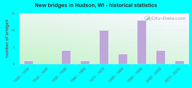
- New bridges - historical statistics
- 11930-1939
- 41950-1959
- 11960-1969
- 101970-1979
- 31980-1989
- 131990-1999
- 42000-2009
- 12010-2019

- Reconstructed bridges - Historical Statistics
- 21990-1999
- 02000-2009
- 22010-2019
- 12020-2022


- Bridge Condition - Deck
- 5.0%Excellent
- 10.0%Very good
- 45.0%Good
- 35.0%Satisfactory
- 5.0%Fair

- Bridge Condition - Superstructure
- 5.0%Excellent
- 10.0%Very good
- 55.0%Good
- 20.0%Satisfactory
- 10.0%Fair

- Bridge Condition - Substructure
- 5.0%Excellent
- 5.0%Very good
- 65.0%Good
- 15.0%Satisfactory
- 10.0%Fair

- Bridge Condition - Channel
- 12.5%Excellent
- 50.0%Very good
- 25.0%Good
- 12.5%Satisfactory
Find on map >> Show street view
Structure Number: B550025, Location: 0.1M E JCT CTH CC (Lat: 45.163011, Lng: -92.592925), Route carried "on" structure: County highway , Year Built: 1957, Status: Open, Structure Length: 3.57m (11.71ft), Average Daily Traffic: 1,750 (year 2019), Average Future Daily Traffic: 3,562 (year 2039), Design Load: H 15, Features Intersected: APPLE RIVER, Facility Carried by Structure: CTH C
Minimum Vertical Clearance: 30+ m (98+ ft), Kilometerpoint: 0.000, Lanes on structure: 2, Owner: County Highway Agency, Approaching Roadway Width: 8.5m (27.9ft), Material/Design: Concrete continuous, Design/Construction: Slab, Number Of Spans In Main Unit: 3, Length of Maximum Span: 13.7m (44.9ft), Curb-To-Curb Width: 8.5m (27.9ft), Out-to-Out Width: 10.1m (33.1ft)
Condition: Deck: Satisfactory, Superstructure: Satisfactory, Substructure: Good, Channel: Good, Operating Rating: 24.0 metric tons, Method Used To Determine Operating Rating: Load Factor (LF), Inventory Rating: 14.6 metric tons, Method Used To Determine Inventory Rating: Load Factor (LF), Structural Evaluation: Meets minimum limits, Deck Geometry: Somewhat better than minimum adequacy, Waterway Adequacy: Equal to present desirable criteria, Approach Roadway Alignment: Equal to present desirable criteria, Designated Inspection Frequency: Every 24 months, Inspection Date: October 2020, Deck Structure Type: Concrete Cast-file-Place, Wearing Surface/Protective System: Wearing Surface: Monolithic Concrete
Find on map >> Show street view
Structure Number: B550026, Location: 0.6M W JCT CTH F (Lat: 44.962425, Lng: -92.743339), Route carried "on" structure: City street , Year Built: 1973, Year Reconstructed: 1997, Status: Open, Structure Length: 7.17m (23.52ft), Average Daily Traffic: 13,800 (year 2018), Average Future Daily Traffic: 16,560 (year 2038), Design Load: HS 20, Features Intersected: IH 94-USH 12-STH 35, Facility Carried by Structure: LRD 11TH ST
Minimum Vertical Clearance: 30+ m (98+ ft), Kilometerpoint: 0.000, Lanes on structure: 2, Lanes under structure: 6, Owner: State Highway Agency, Approaching Roadway Width: 9.1m (29.9ft), Material/Design: Steel continuous, Design/Construction: Stringer/Multi-beam, Number Of Spans In Main Unit: 2, Length of Maximum Span: 35.4m (116.1ft), Curb or Sidewalk Widths: Left: 2.0m (6.6ft), Right: 2.0m (6.6ft), Curb-To-Curb Width: 13.4m (44.0ft), Out-to-Out Width: 17.1m (56.1ft)
Condition: Deck: Satisfactory, Superstructure: Fair, Substructure: Fair, Operating Rating: 52.3 metric tons, Method Used To Determine Operating Rating: Load Factor (LF), Inventory Rating: 30.8 metric tons, Method Used To Determine Inventory Rating: Load Factor (LF), Structural Evaluation: Somewhat better than minimum adequacy, Deck Geometry: Equal to present minimum criteria, Underclear: Equal to present minimum criteria, Approach Roadway Alignment: Equal to present desirable criteria, Designated Inspection Frequency: Every 24 months, Inspection Date: June 2020, Deck Structure Type: Concrete Cast-file-Place, Wearing Surface/Protective System: Wearing Surface: Monolithic Concrete, Deck Protection: Epoxy Coated Reinforcing
Find on map >> Show street view
Structure Number: B550032, Location: 2.0M E JCT USH 12 (J) (Lat: 44.963353, Lng: -92.642411), Route carried "on" structure: Interstate 94, Year Built: 1958, Status: Open, Structure Length: 3.79m (12.43ft), Average Daily Traffic: 20,500 (year 2019), Truck Traffic: 13%, Average Future Daily Traffic: 44,026 (year 2039), Design Load: HS 20+Mod, Features Intersected: LRD KINNEY RD
Minimum Vertical Clearance: 30+ m (98+ ft), Kilometerpoint: 0.000, Lanes on structure: 2, Lanes under structure: 2, Base Highway Network: Yes, Owner: State Highway Agency, Approaching Roadway Width: 11.9m (39.0ft), Skew: 3 degrees, Material/Design: Concrete continuous, Design/Construction: Slab, Number Of Spans In Main Unit: 3, Length of Maximum Span: 14.6m (47.9ft), Curb-To-Curb Width: 11.9m (39.0ft), Out-to-Out Width: 12.8m (42.0ft)
Condition: Deck: Fair, Superstructure: Fair, Substructure: Fair, Operating Rating: 65.0 metric tons, Method Used To Determine Operating Rating: Load Factor (LF), Inventory Rating: 38.9 metric tons, Method Used To Determine Inventory Rating: Load Factor (LF), Structural Evaluation: Somewhat better than minimum adequacy, Deck Geometry: Equal to present minimum criteria, Underclear: Somewhat better than minimum adequacy, Approach Roadway Alignment: Equal to present desirable criteria, Designated Inspection Frequency: Every 24 months, Inspection Date: June 2020, Deck Structure Type: Concrete Cast-file-Place, Wearing Surface/Protective System: Wearing Surface: Low Slump Concrete
Find on map >> Show street view
Structure Number: B55006, Location: 3.2M N JCT STH 64 (Lat: 45.122575, Lng: -92.687981), Route carried "on" structure: County highway , Year Built: 1966, Status: Open, Structure Length: 8.18m (26.84ft), Average Daily Traffic: 5,356 (year 2019), Truck Traffic: 8%, Average Future Daily Traffic: 5,891 (year 2039), Design Load: HS 20, Features Intersected: SOO LINE, Facility Carried by Structure: CTH VV
Minimum Vertical Clearance: 30+ m (98+ ft), Kilometerpoint: 0.000, Lanes on structure: 2, Base Highway Network: Yes, Owner: County Highway Agency, Approaching Roadway Width: 13.4m (44.0ft), Material/Design: Prestressed concrete continuous, Design/Construction: Stringer/Multi-beam, Number Of Spans In Main Unit: 3, Length of Maximum Span: 27.6m (90.6ft), Curb-To-Curb Width: 10.1m (33.1ft), Out-to-Out Width: 11.0m (36.1ft)
Condition: Deck: Good, Superstructure: Good, Substructure: Good, Operating Rating: 41.0 metric tons, Method Used To Determine Operating Rating: Load Factor (LF), Inventory Rating: 25.9 metric tons, Method Used To Determine Inventory Rating: Load Factor (LF), Structural Evaluation: Equal to present minimum criteria, Deck Geometry: Meets minimum limits, Underclear: Better than present minimum criteria, Approach Roadway Alignment: Equal to present minimum criteria, Designated Inspection Frequency: Every 24 months, Inspection Date: October 2020, Deck Structure Type: Concrete Cast-file-Place, Wearing Surface/Protective System: Wearing Surface: Low Slump Concrete
Find on map >> Show street view
Structure Number: B550061, Location: 0.5M W JCT STH 35 TO N (Lat: 44.962903, Lng: -92.758253), Route carried "on" structure: Interstate 94, Year Built: 1973, Year Reconstructed: 2004, Status: Open, Structure Length: 72.55m (238.02ft), Average Daily Traffic: 44,950 (year 2018), Truck Traffic: 12%, Average Future Daily Traffic: 53,940 (year 2038), Design Load: HS 20, Features Intersected: QUIXOTE AVE-ST CROIX RIV
Minimum Vertical Clearance: 30+ m (98+ ft), Kilometerpoint: 0.000, Lanes on structure: 4, Lanes under structure: 2, Base Highway Network: Yes, Owner: State Highway Agency, Approaching Roadway Width: 17.1m (56.1ft), Navigation Control: Yes ( Vertical Clearance: 15.8m (51.8ft), Horizontal Clearance: 95.4m (313.0ft)), Material/Design: Steel continuous, Design/Construction: Stringer/Multi-beam, Number Of Spans In Main Unit: 9, Length of Maximum Span: 118.9m (390.1ft), Curb-To-Curb Width: 18.3m (60.0ft), Out-to-Out Width: 19.2m (63.0ft)
Condition: Deck: Satisfactory, Superstructure: Good, Substructure: Satisfactory, Channel: Very good, Operating Rating: 44.1 metric tons, Method Used To Determine Operating Rating: Load Factor (LF), Inventory Rating: 25.9 metric tons, Method Used To Determine Inventory Rating: Load Factor (LF), Structural Evaluation: Equal to present minimum criteria, Deck Geometry: Meets minimum limits, Underclear: Superior to present desirable criteria, Waterway Adequacy: Equal to present desirable criteria, Approach Roadway Alignment: Equal to present desirable criteria, Designated Inspection Frequency: Every 24 months, Underwater Inspection Frequency: Every 60 months, Other Special Inspection Frequency: Every 72 months, Inspection Date: June 2021, Underwater Inspection Date: October 2021, Other Special Inspection Date: June 2021, Deck Structure Type: Concrete Cast-file-Place, Wearing Surface/Protective System: Wearing Surface: Epoxy Overlay, Deck Protection: Epoxy Coated Reinforcing
Find on map >> Show street view
Structure Number: B550065, Location: 0.2M E JCT STH 35 TO N (Lat: 44.962539, Lng: -92.751025), Route carried "on" structure: Interstate 94, Year Built: 1972, Year Reconstructed: 2019, Status: Open, Structure Length: 5.21m (17.09ft), Average Daily Traffic: 87,000 (year 2019), Truck Traffic: 18%, Average Future Daily Traffic: 111,300 (year 2037), Design Load: HS 20, Features Intersected: LRD FRONT ST
Minimum Vertical Clearance: 30+ m (98+ ft), Kilometerpoint: 0.000, Lanes on structure: 7, Lanes under structure: 2, Base Highway Network: Yes, Owner: State Highway Agency, Approaching Roadway Width: 34.1m (111.9ft), Skew: 3 degrees, Material/Design: Prestressed concrete continuous, Design/Construction: Stringer/Multi-beam, Number Of Spans In Main Unit: 3, Length of Maximum Span: 21.3m (69.9ft), Curb-To-Curb Width: 42.0m (137.8ft), Out-to-Out Width: 42.7m (140.1ft)
Condition: Deck: Very good, Superstructure: Good, Substructure: Good, Operating Rating: 58.8 metric tons, Method Used To Determine Operating Rating: Load Factor (LF), Inventory Rating: 29.2 metric tons, Method Used To Determine Inventory Rating: Load Factor (LF), Structural Evaluation: Better than present minimum criteria, Deck Geometry: Superior to present desirable criteria, Underclear: Equal to present minimum criteria, Approach Roadway Alignment: Equal to present desirable criteria, Designated Inspection Frequency: Every 24 months, Inspection Date: December 2020, Deck Structure Type: Concrete Cast-file-Place, Wearing Surface/Protective System: Wearing Surface: Epoxy Overlay, Deck Protection: Epoxy Coated Reinforcing
Find on map >> Show street view
Structure Number: B550066, Location: 0.6M E MINN STATE LINE (Lat: 44.962508, Lng: -92.752694), Route carried "on" structure: Interstate 94, Year Built: 1972, Year Reconstructed: 2019, Status: Open, Structure Length: 4.08m (13.39ft), Average Daily Traffic: 87,000 (year 2019), Truck Traffic: 18%, Average Future Daily Traffic: 111,300 (year 2037), Design Load: HS 20, Features Intersected: STH 35 SB
Minimum Vertical Clearance: 30+ m (98+ ft), Kilometerpoint: 0.000, Lanes on structure: 7, Lanes under structure: 2, Base Highway Network: Yes, Owner: State Highway Agency, Approaching Roadway Width: 34.1m (111.9ft), Skew: 1 degrees, Material/Design: Prestressed concrete continuous, Design/Construction: Stringer/Multi-beam, Number Of Spans In Main Unit: 3, Length of Maximum Span: 21.6m (70.9ft), Curb-To-Curb Width: 43.0m (141.1ft), Out-to-Out Width: 43.8m (143.7ft)
Condition: Deck: Very good, Superstructure: Good, Substructure: Good, Operating Rating: 53.9 metric tons, Method Used To Determine Operating Rating: Load Factor (LF), Inventory Rating: 32.4 metric tons, Method Used To Determine Inventory Rating: Load Factor (LF), Structural Evaluation: Better than present minimum criteria, Deck Geometry: Superior to present desirable criteria, Underclear: Somewhat better than minimum adequacy, Approach Roadway Alignment: Equal to present desirable criteria, Designated Inspection Frequency: Every 24 months, Inspection Date: December 2020, Deck Structure Type: Concrete Cast-file-Place, Wearing Surface/Protective System: Wearing Surface: Epoxy Overlay, Deck Protection: Epoxy Coated Reinforcing
Find on map >> Show street view
Structure Number: B550073, Location: 1.9M N JCT IH 94 TO W (Lat: 44.988606, Lng: -92.757042), Route carried "on" structure: State highway 35, Year Built: 1978, Status: Open, Structure Length: 11.54m (37.86ft), Average Daily Traffic: 11,900 (year 2018), Truck Traffic: 7%, Average Future Daily Traffic: 14,280 (year 2038), Design Load: HS 20, Features Intersected: LAKE MALLALIEU
Minimum Vertical Clearance: 30+ m (98+ ft), Kilometerpoint: 0.000, Lanes on structure: 2, Owner: State Highway Agency, Approaching Roadway Width: 14.6m (47.9ft), Material/Design: Prestressed concrete continuous, Design/Construction: Stringer/Multi-beam, Number Of Spans In Main Unit: 3, Length of Maximum Span: 38.2m (125.3ft), Curb or Sidewalk Widths: Left: 2.0m (6.6ft), Right: 3.0m (9.8ft), Curb-To-Curb Width: 14.6m (47.9ft), Out-to-Out Width: 19.2m (63.0ft)
Condition: Deck: Satisfactory, Superstructure: Satisfactory, Substructure: Good, Channel: Very good, Operating Rating: 76.7 metric tons, Method Used To Determine Operating Rating: Load Factor (LF), Inventory Rating: 32.4 metric tons, Method Used To Determine Inventory Rating: Load Factor (LF), Structural Evaluation: Equal to present minimum criteria, Deck Geometry: Superior to present desirable criteria, Waterway Adequacy: Equal to present desirable criteria, Approach Roadway Alignment: Equal to present desirable criteria, Designated Inspection Frequency: Every 24 months, Underwater Inspection Frequency: Every 72 months, Inspection Date: September 2020, Underwater Inspection Date: July 2019, Deck Structure Type: Concrete Cast-file-Place, Wearing Surface/Protective System: Wearing Surface: Low Slump Concrete
Find on map >> Show street view
Structure Number: B55008, Location: 1.8M S JCT CTH TT (Lat: 44.951589, Lng: -92.517247), Route carried "on" structure: City street , Year Built: 1980, Status: Open, Structure Length: 2.48m (8.14ft), Average Daily Traffic: 176 (year 2019), Average Future Daily Traffic: 191 (year 2039), Design Load: H 20, Features Intersected: KINNICKINNIC RIVER, Facility Carried by Structure: LRD 140TH ST
Minimum Vertical Clearance: 30+ m (98+ ft), Kilometerpoint: 0.000, Lanes on structure: 2, Owner: Town or Township Highway Agency, Approaching Roadway Width: 7.9m (25.9ft), Skew: 2 degrees, Material/Design: Concrete, Design/Construction: Slab, Number Of Spans In Main Unit: 2, Length of Maximum Span: 11.9m (39.0ft), Curb-To-Curb Width: 7.9m (25.9ft), Out-to-Out Width: 8.5m (27.9ft)
Condition: Deck: Good, Superstructure: Good, Substructure: Very good, Channel: Satisfactory, Operating Rating: 47.4 metric tons, Method Used To Determine Operating Rating: Load Factor (LF), Inventory Rating: 27.5 metric tons, Method Used To Determine Inventory Rating: Load Factor (LF), Structural Evaluation: Equal to present minimum criteria, Deck Geometry: Somewhat better than minimum adequacy, Waterway Adequacy: Equal to present desirable criteria, Approach Roadway Alignment: Equal to present desirable criteria, Designated Inspection Frequency: Every 24 months, Inspection Date: November 2020, Deck Structure Type: Concrete Cast-file-Place, Wearing Surface/Protective System: Wearing Surface: Monolithic Concrete
Find on map >> Show street view
Structure Number: B550098, Location: 0.4M E JCT STH 35 (Lat: 44.984539, Lng: -92.749461), Route carried "on" structure: City street , Year Built: 1987, Status: Open, Structure Length: 4.04m (13.25ft), Average Daily Traffic: 865 (year 2019), Average Future Daily Traffic: 861 (year 2039), Design Load: HS 20, Features Intersected: UNION PACIFIC RR, Facility Carried by Structure: LRD SEVENTH ST (DE
Minimum Vertical Clearance: 30+ m (98+ ft), Kilometerpoint: 0.000, Lanes on structure: 2, Owner: City or Municipal Highway Agency, Approaching Roadway Width: 7.9m (25.9ft), Skew: 2 degrees, Material/Design: Steel continuous, Design/Construction: Stringer/Multi-beam, Number Of Spans In Main Unit: 3, Length of Maximum Span: 18.3m (60.0ft), Curb or Sidewalk Widths: Left: 2.0m (6.6ft), Right: 0.0m, Curb-To-Curb Width: 7.9m (25.9ft), Out-to-Out Width: 10.5m (34.4ft)
Condition: Deck: Satisfactory, Superstructure: Good, Substructure: Good, Operating Rating: 58.8 metric tons, Method Used To Determine Operating Rating: Load Factor (LF), Inventory Rating: 34.0 metric tons, Method Used To Determine Inventory Rating: Load Factor (LF), Structural Evaluation: Better than present minimum criteria, Deck Geometry: Somewhat better than minimum adequacy, Underclear: Better than present minimum criteria, Approach Roadway Alignment: Equal to present minimum criteria, Designated Inspection Frequency: Every 24 months, Inspection Date: November 2020, Deck Structure Type: Concrete Cast-file-Place, Wearing Surface/Protective System: Wearing Surface: Monolithic Concrete, Deck Protection: Epoxy Coated Reinforcing
Find on map >> Show street view
Structure Number: B550118, Location: 1.0M S JCT CTH UU (Lat: 44.963150, Lng: -92.720908), Route carried "on" structure: City street , Year Built: 1991, Status: Open, Structure Length: 7.14m (23.43ft), Average Daily Traffic: 34,000 (year 2019), Truck Traffic: 1%, Average Future Daily Traffic: 35,020 (year 2039), Design Load: HS 20, Features Intersected: IH 94-USH 12-STH 35, Facility Carried by Structure: LRD CARMICHAEL RD
Minimum Vertical Clearance: 30+ m (98+ ft), Kilometerpoint: 0.000, Lanes on structure: 7, Lanes under structure: 6, Owner: State Highway Agency, Approaching Roadway Width: 26.2m (86.0ft), Skew: 20 degrees, Material/Design: Prestressed concrete continuous, Design/Construction: Stringer/Multi-beam, Number Of Spans In Main Unit: 2, Length of Maximum Span: 35.1m (115.2ft), Curb or Sidewalk Widths: Left: 3.0m (9.8ft), Right: 0.0m, Curb-To-Curb Width: 28.7m (94.2ft), Out-to-Out Width: 34.0m (111.5ft)
Condition: Deck: Satisfactory, Superstructure: Satisfactory, Substructure: Satisfactory, Operating Rating: 82.0 metric tons, Method Used To Determine Operating Rating: Load Factor (LF), Inventory Rating: 43.7 metric tons, Method Used To Determine Inventory Rating: Load Factor (LF), Structural Evaluation: Equal to present minimum criteria, Deck Geometry: Somewhat better than minimum adequacy, Underclear: Equal to present minimum criteria, Approach Roadway Alignment: Equal to present desirable criteria, Designated Inspection Frequency: Every 24 months, Inspection Date: June 2020, Deck Structure Type: Concrete Cast-file-Place, Wearing Surface/Protective System: Wearing Surface: Monolithic Concrete, Deck Protection: Epoxy Coated Reinforcing
Find on map >> Show street view
Structure Number: B55012, Location: 1.9M N JCT USH 12 (Lat: 45.019358, Lng: -92.436244), Route carried "on" structure: County highway , Year Built: 1994, Status: Open, Structure Length: 0.70m (2.30ft), Average Daily Traffic: 2,321 (year 2019), Truck Traffic: 4%, Average Future Daily Traffic: 2,553 (year 2039), Design Load: HS 20, Features Intersected: GIRARDS CREEK, Facility Carried by Structure: CTH T
Minimum Vertical Clearance: 30+ m (98+ ft), Kilometerpoint: 0.000, Lanes on structure: 2, Owner: County Highway Agency, Approaching Roadway Width: 11.0m (36.1ft), Skew: 1 degrees, Material/Design: Concrete continuous, Design/Construction: Culvert, Number Of Spans In Main Unit: 2, Length of Maximum Span: 3.0m (9.8ft), Curb-To-Curb Width: 10.6m (34.8ft), Out-to-Out Width: 11.4m (37.4ft)
Condition: Channel: Very good, Culverts: Good, Operating Rating: 53.9 metric tons, Method Used To Determine Operating Rating: Field evaluation and documented engineering judgment, Inventory Rating: 32.4 metric tons, Method Used To Determine Inventory Rating: Field evaluation and documented engineering judgment, Structural Evaluation: Better than present minimum criteria, Deck Geometry: Somewhat better than minimum adequacy, Waterway Adequacy: Equal to present desirable criteria, Approach Roadway Alignment: Equal to present desirable criteria, Designated Inspection Frequency: Every 24 months, Inspection Date: October 2020, Deck Structure Type: Concrete Cast-file-Place, Wearing Surface/Protective System: Wearing Surface: Monolithic Concrete, Deck Protection: Epoxy Coated Reinforcing
Find on map >> Show street view
Structure Number: B550126, Location: AT MINNESOTA STATE LINE (Lat: 44.962300, Lng: -92.767500), Route carried "on" structure: Interstate 94, Year Built: 1995, Status: Open, Structure Length: 72.39m (237.50ft), Average Daily Traffic: 44,950 (year 2018), Average Future Daily Traffic: 53,940 (year 2038), Design Load: HS 20, Features Intersected: LRD QUIXOTE AVE-ST CROIX
Minimum Vertical Clearance: 30+ m (98+ ft), Kilometerpoint: 0.000, Lanes on structure: 4, Lanes under structure: 2, Base Highway Network: Yes, Owner: State Highway Agency, Approaching Roadway Width: 20.7m (67.9ft), Navigation Control: Yes ( Vertical Clearance: 18.3m (60.0ft), Horizontal Clearance: 97.8m (320.9ft)), Material/Design: Steel continuous, Design/Construction: Stringer/Multi-beam, Number Of Spans In Main Unit: 9, Length of Maximum Span: 118.9m (390.1ft), Curb or Sidewalk Widths: Left: 0.0m, Right: 3.0m (9.8ft), Curb-To-Curb Width: 20.7m (67.9ft), Out-to-Out Width: 24.4m (80.1ft)
Condition: Deck: Satisfactory, Superstructure: Good, Substructure: Good, Channel: Very good, Operating Rating: 55.5 metric tons, Method Used To Determine Operating Rating: Load Factor (LF), Inventory Rating: 32.4 metric tons, Method Used To Determine Inventory Rating: Load Factor (LF), Structural Evaluation: Better than present minimum criteria, Deck Geometry: Equal to present minimum criteria, Underclear: Superior to present desirable criteria, Waterway Adequacy: Equal to present desirable criteria, Approach Roadway Alignment: Equal to present desirable criteria, Designated Inspection Frequency: Every 24 months, Underwater Inspection Frequency: Every 60 months, Inspection Date: June 2021, Underwater Inspection Date: October 2021, Deck Structure Type: Concrete Cast-file-Place, Wearing Surface/Protective System: Wearing Surface: Epoxy Overlay, Deck Protection: Epoxy Coated Reinforcing
Find on map >> Show street view
Structure Number: B550132, Location: 1.3M S JCT IH 94 (Lat: 44.949047, Lng: -92.727058), Route carried "on" structure: City street , Year Built: 1991, Status: Open, Structure Length: 2.54m (8.33ft), Average Daily Traffic: 3,502 (year 2019), Average Future Daily Traffic: 3,852 (year 2039), Design Load: HS 20, Features Intersected: LRD ALBERT ROAD, Facility Carried by Structure: LRD CARMICHAEL RD
Minimum Vertical Clearance: 30+ m (98+ ft), Kilometerpoint: 0.000, Lanes on structure: 2, Lanes under structure: 2, Owner: City or Municipal Highway Agency, Approaching Roadway Width: 8.5m (27.9ft), Material/Design: Steel, Design/Construction: Stringer/Multi-beam, Number Of Spans In Main Unit: 1, Length of Maximum Span: 24.1m (79.1ft), Curb-To-Curb Width: 9.1m (29.9ft), Out-to-Out Width: 10.1m (33.1ft)
Condition: Deck: Good, Superstructure: Good, Substructure: Good, Operating Rating: 80.0 metric tons, Method Used To Determine Operating Rating: Load Factor (LF), Inventory Rating: 42.1 metric tons, Method Used To Determine Inventory Rating: Load Factor (LF), Structural Evaluation: Better than present minimum criteria, Deck Geometry: Meets minimum limits, Underclear: Equal to present minimum criteria, Approach Roadway Alignment: Equal to present desirable criteria, Designated Inspection Frequency: Every 48 months, Inspection Date: November 2020, Deck Structure Type: Concrete Cast-file-Place, Wearing Surface/Protective System: Wearing Surface: Monolithic Concrete, Deck Protection: Epoxy Coated Reinforcing
Find on map >> Show street view
Structure Number: B550133, Location: 1.3M S JCT IH 94 (Lat: 44.948814, Lng: -92.727592), Route carried "on" structure: City street , Year Built: 1991, Status: Open, Structure Length: 2.54m (8.33ft), Average Daily Traffic: 3,502 (year 2019), Average Future Daily Traffic: 3,852 (year 2039), Design Load: HS 20, Features Intersected: LRD ALBERT ROAD, Facility Carried by Structure: LRD CARMICHAEL RD
Minimum Vertical Clearance: 30+ m (98+ ft), Kilometerpoint: 0.000, Lanes on structure: 2, Lanes under structure: 2, Owner: City or Municipal Highway Agency, Approaching Roadway Width: 8.5m (27.9ft), Material/Design: Steel, Design/Construction: Stringer/Multi-beam, Number Of Spans In Main Unit: 1, Length of Maximum Span: 24.1m (79.1ft), Curb-To-Curb Width: 9.1m (29.9ft), Out-to-Out Width: 10.1m (33.1ft)
Condition: Deck: Good, Superstructure: Good, Substructure: Good, Operating Rating: 80.0 metric tons, Method Used To Determine Operating Rating: Load Factor (LF), Inventory Rating: 42.1 metric tons, Method Used To Determine Inventory Rating: Load Factor (LF), Structural Evaluation: Better than present minimum criteria, Deck Geometry: Meets minimum limits, Underclear: Equal to present minimum criteria, Approach Roadway Alignment: Equal to present desirable criteria, Designated Inspection Frequency: Every 48 months, Inspection Date: November 2020, Deck Structure Type: Concrete Cast-file-Place, Wearing Surface/Protective System: Wearing Surface: Monolithic Concrete, Deck Protection: Epoxy Coated Reinforcing
Find on map >> Show street view
Structure Number: B550146, Location: .1M E JCT CTH UU (Lat: 44.958689, Lng: -92.694933), Route carried "on" structure: City street , Year Built: 1999, Status: Open, Structure Length: 6.90m (22.64ft), Average Daily Traffic: 4,300 (year 2019), Average Future Daily Traffic: 5,160 (year 2039), Design Load: HS 20, Features Intersected: STH 35, Facility Carried by Structure: LRD STAGELINE RD
Minimum Vertical Clearance: 30+ m (98+ ft), Kilometerpoint: 0.000, Lanes on structure: 2, Lanes under structure: 4, Owner: State Highway Agency, Approaching Roadway Width: 11.0m (36.1ft), Material/Design: Prestressed concrete continuous, Design/Construction: Stringer/Multi-beam, Number Of Spans In Main Unit: 2, Length of Maximum Span: 34.1m (111.9ft), Curb-To-Curb Width: 11.0m (36.1ft), Out-to-Out Width: 11.9m (39.0ft)
Condition: Deck: Good, Superstructure: Very good, Substructure: Good, Operating Rating: 76.7 metric tons, Method Used To Determine Operating Rating: Load Factor (LF), Inventory Rating: 40.5 metric tons, Method Used To Determine Inventory Rating: Load Factor (LF), Structural Evaluation: Better than present minimum criteria, Deck Geometry: Somewhat better than minimum adequacy, Underclear: Equal to present minimum criteria, Approach Roadway Alignment: Equal to present desirable criteria, Designated Inspection Frequency: Every 48 months, Inspection Date: September 2020, Deck Structure Type: Concrete Cast-file-Place, Wearing Surface/Protective System: Wearing Surface: Monolithic Concrete, Deck Protection: Epoxy Coated Reinforcing
Find on map >> Show street view
Structure Number: B550147, Location: 3.0M E JCT CTH F (Lat: 44.963711, Lng: -92.694886), Route carried "on" structure: Interstate 94, Year Built: 2000, Status: Open, Structure Length: 5.01m (16.44ft), Average Daily Traffic: 33,300 (year 2019), Truck Traffic: 13%, Average Future Daily Traffic: 35,505 (year 2039), Design Load: HS 20, Features Intersected: STH 35
Minimum Vertical Clearance: 30+ m (98+ ft), Kilometerpoint: 0.000, Lanes on structure: 3, Lanes under structure: 3, Base Highway Network: Yes, Owner: State Highway Agency, Approaching Roadway Width: 17.1m (56.1ft), Material/Design: Prestressed concrete continuous, Design/Construction: Stringer/Multi-beam, Number Of Spans In Main Unit: 2, Length of Maximum Span: 24.7m (81.0ft), Curb-To-Curb Width: 17.1m (56.1ft), Out-to-Out Width: 18.0m (59.1ft)
Condition: Deck: Good, Superstructure: Good, Substructure: Good, Operating Rating: 71.8 metric tons, Method Used To Determine Operating Rating: Load Factor (LF), Inventory Rating: 37.3 metric tons, Method Used To Determine Inventory Rating: Load Factor (LF), Structural Evaluation: Better than present minimum criteria, Deck Geometry: Equal to present minimum criteria, Underclear: Equal to present minimum criteria, Approach Roadway Alignment: Equal to present desirable criteria, Designated Inspection Frequency: Every 48 months, Inspection Date: June 2020, Deck Structure Type: Concrete Cast-file-Place, Wearing Surface/Protective System: Wearing Surface: Monolithic Concrete, Deck Protection: Epoxy Coated Reinforcing
Find on map >> Show street view
Structure Number: B550148, Location: 7.0M W JCT STH 65 (Lat: 44.964072, Lng: -92.694358), Route carried "on" structure: Interstate 94, Year Built: 2000, Year Reconstructed: 2020, Status: Open, Structure Length: 5.01m (16.44ft), Average Daily Traffic: 36,975 (year 2019), Truck Traffic: 18%, Average Future Daily Traffic: 45,575 (year 2037), Design Load: HS 20, Features Intersected: STH 35
Minimum Vertical Clearance: 30+ m (98+ ft), Kilometerpoint: 0.000, Lanes on structure: 4, Lanes under structure: 3, Base Highway Network: Yes, Owner: State Highway Agency, Approaching Roadway Width: 21.3m (69.9ft), Material/Design: Prestressed concrete continuous, Design/Construction: Stringer/Multi-beam, Number Of Spans In Main Unit: 2, Length of Maximum Span: 24.7m (81.0ft), Curb-To-Curb Width: 21.3m (69.9ft), Out-to-Out Width: 22.0m (72.2ft)
Condition: Deck: Good, Superstructure: Good, Substructure: Good, Operating Rating: 58.8 metric tons, Method Used To Determine Operating Rating: Load Factor (LF), Inventory Rating: 32.4 metric tons, Method Used To Determine Inventory Rating: Load Factor (LF), Structural Evaluation: Better than present minimum criteria, Deck Geometry: Better than present minimum criteria, Underclear: Meets minimum limits, Approach Roadway Alignment: Equal to present desirable criteria, Designated Inspection Frequency: Every 48 months, Inspection Date: June 2020, Deck Structure Type: Concrete Cast-file-Place, Wearing Surface/Protective System: Wearing Surface: Monolithic Concrete, Deck Protection: Epoxy Coated Reinforcing
Find on map >> Show street view
Structure Number: B550151, Location: 0.8M E JCT STH 35 (J) (Lat: 44.963522, Lng: -92.679994), Route carried "on" structure: US 12, Year Built: 1999, Status: Open, Structure Length: 6.88m (22.57ft), Average Daily Traffic: 14,900 (year 2018), Truck Traffic: 5%, Average Future Daily Traffic: 17,880 (year 2038), Design Load: HS 20, Features Intersected: IH 94
Minimum Vertical Clearance: 30+ m (98+ ft), Kilometerpoint: 0.000, Lanes on structure: 4, Lanes under structure: 6, Owner: State Highway Agency, Approaching Roadway Width: 21.9m (71.9ft), Skew: 30 degrees, Material/Design: Prestressed concrete continuous, Design/Construction: Stringer/Multi-beam, Number Of Spans In Main Unit: 2, Length of Maximum Span: 33.8m (110.9ft), Curb or Sidewalk Widths: Left: 1.5m (4.9ft), Right: 0.0m, Curb-To-Curb Width: 25.6m (84.0ft), Out-to-Out Width: 32.6m (107.0ft)
Condition: Deck: Good, Superstructure: Very good, Substructure: Good, Operating Rating: 71.8 metric tons, Method Used To Determine Operating Rating: Load Factor (LF), Inventory Rating: 37.3 metric tons, Method Used To Determine Inventory Rating: Load Factor (LF), Structural Evaluation: Better than present minimum criteria, Deck Geometry: Superior to present desirable criteria, Underclear: Equal to present minimum criteria, Approach Roadway Alignment: Equal to present desirable criteria, Designated Inspection Frequency: Every 48 months, Inspection Date: June 2020, Deck Structure Type: Concrete Cast-file-Place, Wearing Surface/Protective System: Wearing Surface: Monolithic Concrete, Deck Protection: Epoxy Coated Reinforcing
Find on map >> Show street view
Structure Number: B550267, Location: 1.1M N JCT CTH A (Lat: 45.002050, Lng: -92.720547), Route carried "on" structure: City street , Year Built: 2014, Status: Open, Structure Length: 1.60m (5.25ft), Average Daily Traffic: 850 (year 2019), Truck Traffic: 3%, Average Future Daily Traffic: 911 (year 2039), Design Load: HL 93, Features Intersected: WILLOW RIVER, Facility Carried by Structure: LRD TROUT BROOK RD
Minimum Vertical Clearance: 30+ m (98+ ft), Kilometerpoint: 0.000, Lanes on structure: 2, Owner: Town or Township Highway Agency, Approaching Roadway Width: 1.2m (3.9ft), Skew: 1 degrees, Material/Design: Concrete, Design/Construction: Slab, Number Of Spans In Main Unit: 1, Length of Maximum Span: 15.2m (49.9ft), Curb-To-Curb Width: 9.1m (29.9ft), Out-to-Out Width: 9.8m (32.2ft)
Condition: Deck: Excellent, Superstructure: Excellent, Substructure: Excellent, Channel: Excellent, Operating Rating: 46.0 metric tons, Method Used To Determine Operating Rating: Load and Resistance Factor Rating (LRFR) rating reported by rating factor(RF) method using HL-93 loadings, Inventory Rating: 35.6 metric tons, Method Used To Determine Inventory Rating: Load and Resistance Factor Rating (LRFR) rating reported by rating factor(RF) method using HL-93 loadings, Structural Evaluation: Superior to present desirable criteria, Deck Geometry: Equal to present minimum criteria, Waterway Adequacy: Superior to present desirable criteria, Approach Roadway Alignment: Equal to present minimum criteria, Designated Inspection Frequency: Every 48 months, Inspection Date: November 2020, Deck Structure Type: Concrete Cast-file-Place, Wearing Surface/Protective System: Wearing Surface: Monolithic Concrete, Membrane: Other, Deck Protection: Epoxy Coated Reinforcing
Find on map >> Show street view
Structure Number: P550146, Location: 1.3M N JCT CTH A (Lat: 45.004072, Lng: -92.721125), Route carried "on" structure: City street , Year Built: 1975, Status: Posted for load, Structure Length: 3.31m (10.86ft), Average Daily Traffic: 850 (year 2019), Average Future Daily Traffic: 1,856 (year 2039), Design Load: H 20, Features Intersected: WILLOW RIVER, Facility Carried by Structure: LRD TROUT BROOK RD
Minimum Vertical Clearance: 30+ m (98+ ft), Kilometerpoint: 0.000, Lanes on structure: 2, Owner: Town or Township Highway Agency, Approaching Roadway Width: 9.1m (29.9ft), Material/Design: Prestressed concrete, Design/Construction: Channel Beam, Number Of Spans In Main Unit: 3, Length of Maximum Span: 10.8m (35.4ft), Curb-To-Curb Width: 9.1m (29.9ft), Out-to-Out Width: 9.7m (31.8ft)
Condition: Deck: Good, Superstructure: Satisfactory, Substructure: Satisfactory, Channel: Good, Operating Rating: 27.8 metric tons, Method Used To Determine Operating Rating: Load Factor (LF), Inventory Rating: 13.0 metric tons, Method Used To Determine Inventory Rating: Load Factor (LF), Structural Evaluation: Meets minimum limits, Deck Geometry: Equal to present minimum criteria, Waterway Adequacy: Better than present minimum criteria, Approach Roadway Alignment: Equal to present minimum criteria, Designated Inspection Frequency: Every 24 months, Inspection Date: November 2020, Deck Structure Type: Concrete Cast-file-Place, Wearing Surface/Protective System: Wearing Surface: Bituminous
Find on map >> Show street view
Structure Number: B550026, Location: 0.6M E JCT STH 35 TO N (Lat: 44.962425, Lng: -92.743339), Route carried "under" structure: Interstate 94, Year Built: 1973, Structure Length: 0. m, Average Daily Traffic: 89,900 (year 2018), Truck Traffic: 1%, Features Intersected: IH 94-USH 12-STH 35, Facility Carried by Structure: LRD 11TH ST
Minimum Vertical Clearance: 6.06m (19.88ft), Kilometerpoint: 0.000, Lanes on structure: 2, Lanes under structure: 6, Material/Design: Steel continuous, Design/Construction: Stringer/Multi-beam, Length of Maximum Span: 35.4m (116.1ft)
Find on map >> Show street view
Structure Number: B550031, Location: 0.5M N JCT CTH N (Lat: 44.963717, Lng: -92.641633), Route carried "under" structure: City street , Year Built: 1958, Structure Length: 0. m, Average Daily Traffic: 1,300 (year 2019), Features Intersected: LRD KINNEY RD, Facility Carried by Structure: IH 94 WB
Minimum Vertical Clearance: 4.67m (15.32ft), Kilometerpoint: 0.000, Lanes on structure: 2, Lanes under structure: 2, Material/Design: Concrete continuous, Design/Construction: Slab, Length of Maximum Span: 14.6m (47.9ft)
Find on map >> Show street view
Structure Number: B550032, Location: 0.5M N JCT CTH N (Lat: 44.963353, Lng: -92.642411), Route carried "under" structure: City street , Year Built: 1958, Structure Length: 0. m, Average Daily Traffic: 1,300 (year 2019), Features Intersected: LRD KINNEY RD, Facility Carried by Structure: IH 94 EB
Minimum Vertical Clearance: 4.62m (15.16ft), Kilometerpoint: 0.000, Lanes on structure: 2, Lanes under structure: 2, Material/Design: Concrete continuous, Design/Construction: Slab, Length of Maximum Span: 14.6m (47.9ft)
Find on map >> Show street view
Structure Number: B550061, Location: AT USH 12 (Lat: 44.962903, Lng: -92.758253), Route carried "under" structure: Other road , Year Built: 1973, Structure Length: 0. m, Average Daily Traffic: 10 (year 2019), Features Intersected: QUIXOTE AVE-ST CROIX RIV, Facility Carried by Structure: IH 94 WB-USH 12 WB
Minimum Vertical Clearance: 10.72m (35.17ft), Kilometerpoint: 0.000, Lanes on structure: 4, Lanes under structure: 2, Material/Design: Steel continuous, Design/Construction: Stringer/Multi-beam, Length of Maximum Span: 118.9m (390.1ft)
Find on map >> Show street view
Structure Number: B550065, Location: 0.3M S JCT STH 35 (Lat: 44.962539, Lng: -92.751025), Route carried "under" structure: City street , Year Built: 1972, Structure Length: 0. m, Average Daily Traffic: 100 (year 2019), Truck Traffic: 5%, Features Intersected: LRD FRONT ST, Facility Carried by Structure: IH 94-USH 12-STH 3
Minimum Vertical Clearance: 4.62m (15.16ft), Kilometerpoint: 0.000, Lanes on structure: 7, Lanes under structure: 2, Material/Design: Prestressed concrete continuous, Design/Construction: Stringer/Multi-beam, Length of Maximum Span: 21.3m (69.9ft)
Find on map >> Show street view
Structure Number: B550066, Location: AT JCT IH 94 (Lat: 44.962508, Lng: -92.752694), Route carried "under" structure: State highway 35, Year Built: 1972, Structure Length: 0. m, Average Daily Traffic: 9,650 (year 2019), Truck Traffic: 12%, Features Intersected: STH 35 SB, Facility Carried by Structure: IH 94-USH 12-STH 3
Minimum Vertical Clearance: 4.52m (14.83ft), Kilometerpoint: 0.000, Lanes on structure: 7, Lanes under structure: 2, Material/Design: Prestressed concrete continuous, Design/Construction: Stringer/Multi-beam, Length of Maximum Span: 21.6m (70.9ft)
Find on map >> Show street view
Structure Number: B550084, Location: 0.6M E JCT STH 35 (Lat: 44.984681, Lng: -92.749528), Route carried "under" structure: City street , Year Built: 1987, Structure Length: 0. m, Average Daily Traffic: 2,530 (year 2019), Features Intersected: LRD A ELEVENTH ST, Facility Carried by Structure: CNW RR
Minimum Vertical Clearance: 4.70m (15.42ft), Kilometerpoint: 0.000, Lanes under structure: 2, Material/Design: Steel, Design/Construction: Stringer/Multi-beam, Length of Maximum Span: 18.3m (60.0ft)
Find on map >> Show street view
Structure Number: B550118, Location: 1.7M E JCT STH 35 TO N (Lat: 44.963150, Lng: -92.720908), Route carried "under" structure: Interstate 94, Year Built: 1991, Structure Length: 0. m, Average Daily Traffic: 73,000 (year 2019), Truck Traffic: 12%, Features Intersected: IH 94-USH 12-STH 35, Facility Carried by Structure: LRD CARMICHAEL RD
Minimum Vertical Clearance: 5.12m (16.80ft), Kilometerpoint: 0.000, Lanes on structure: 7, Lanes under structure: 6, Material/Design: Prestressed concrete continuous, Design/Construction: Stringer/Multi-beam, Length of Maximum Span: 35.1m (115.2ft)
Find on map >> Show street view
Structure Number: B550126, Location: 0.4M N JCT STH 95 (Lat: 44.962300, Lng: -92.767500), Route carried "under" structure: City street , Year Built: 1995, Structure Length: 0. m, Average Daily Traffic: 10 (year 2019), Features Intersected: LRD QUIXOTE AVE-ST CROIX, Facility Carried by Structure: IH 94 EB-USH 12 EB
Minimum Vertical Clearance: 9.75m (31.99ft), Kilometerpoint: 0.000, Lanes on structure: 4, Lanes under structure: 2, Material/Design: Steel continuous, Design/Construction: Stringer/Multi-beam, Length of Maximum Span: 118.9m (390.1ft)
Find on map >> Show street view
Structure Number: B550132, Location: 0.1M S JCT BIENEMAN DR (Lat: 44.949047, Lng: -92.727058), Route carried "under" structure: City street , Year Built: 1991, Structure Length: 0. m, Average Daily Traffic: 99 (year 2019), Features Intersected: LRD ALBERT ROAD, Facility Carried by Structure: LRD CARMICHAEL RD
Minimum Vertical Clearance: 4.60m (15.09ft), Kilometerpoint: 0.000, Lanes on structure: 2, Lanes under structure: 2, Material/Design: Steel, Design/Construction: Stringer/Multi-beam, Length of Maximum Span: 24.1m (79.1ft)
Find on map >> Show street view
Structure Number: B550133, Location: 0.1M S JCT BIENEMAN DR (Lat: 44.948814, Lng: -92.727592), Route carried "under" structure: City street , Year Built: 1991, Structure Length: 0. m, Average Daily Traffic: 99 (year 2019), Features Intersected: LRD ALBERT ROAD, Facility Carried by Structure: LRD CARMICHAEL RD
Minimum Vertical Clearance: 4.50m (14.76ft), Kilometerpoint: 0.000, Lanes on structure: 2, Lanes under structure: 2, Material/Design: Steel, Design/Construction: Stringer/Multi-beam, Length of Maximum Span: 24.1m (79.1ft)
Find on map >> Show street view
Structure Number: B550146, Location: 6.6M N JCT STH 65 (Lat: 44.958689, Lng: -92.694933), Route carried "under" structure: State highway 35, Year Built: 1999, Structure Length: 0. m, Average Daily Traffic: 17,500 (year 2019), Truck Traffic: 8%, Features Intersected: STH 35, Facility Carried by Structure: LRD STAGELINE RD
Minimum Vertical Clearance: 5.08m (16.67ft), Kilometerpoint: 0.000, Lanes on structure: 2, Lanes under structure: 4, Material/Design: Prestressed concrete continuous, Design/Construction: Stringer/Multi-beam, Length of Maximum Span: 34.1m (111.9ft)
Find on map >> Show street view
Structure Number: B550147, Location: 7.0M N JCT CTH FF (Lat: 44.963711, Lng: -92.694886), Route carried "under" structure: State highway 35, Year Built: 2000, Structure Length: 0. m, Average Daily Traffic: 10,300 (year 2019), Features Intersected: STH 35, Facility Carried by Structure: IH 94 EB
Minimum Vertical Clearance: 4.98m (16.34ft), Kilometerpoint: 0.000, Lanes on structure: 3, Lanes under structure: 3, Material/Design: Prestressed concrete continuous, Design/Construction: Stringer/Multi-beam, Length of Maximum Span: 24.7m (81.0ft)
Find on map >> Show street view
Structure Number: B550148, Location: 7.0M N JCT CTH FF (Lat: 44.964072, Lng: -92.694358), Route carried "under" structure: State highway 35, Year Built: 2000, Structure Length: 0. m, Average Daily Traffic: 10,800 (year 2019), Truck Traffic: 12%, Features Intersected: STH 35, Facility Carried by Structure: IH 94 WB
Minimum Vertical Clearance: 5.31m (17.42ft), Kilometerpoint: 0.000, Lanes on structure: 4, Lanes under structure: 3, Material/Design: Prestressed concrete continuous, Design/Construction: Stringer/Multi-beam, Length of Maximum Span: 24.7m (81.0ft)
Find on map >> Show street view
Structure Number: B550151, Location: 0.7M E JCT STH 35 (J) (Lat: 44.963522, Lng: -92.679994), Route carried "under" structure: Interstate 94, Year Built: 1999, Structure Length: 0. m, Average Daily Traffic: 57,700 (year 2018), Truck Traffic: 13%, Features Intersected: IH 94, Facility Carried by Structure: USH 12
Minimum Vertical Clearance: 5.09m (16.70ft), Kilometerpoint: 0.000, Lanes on structure: 4, Lanes under structure: 6, Material/Design: Prestressed concrete continuous, Design/Construction: Stringer/Multi-beam, Length of Maximum Span: 33.8m (110.9ft)
Find on map >> Show street view
Structure Number: B550917, Location: 1.8M N JCT IH 94 TO W (Lat: 44.986667, Lng: -92.756667), Route carried "under" structure: State highway 35, Year Built: 1934, Structure Length: 0. m, Average Daily Traffic: 99 (year 2019), Features Intersected: STH 35-2ND ST, Facility Carried by Structure: CNW RR
Minimum Vertical Clearance: 4.24m (13.91ft), Kilometerpoint: 0.000, Lanes under structure: 2, Material/Design: Steel, Design/Construction: Girder and Floorbeam System, Length of Maximum Span: 17.7m (58.1ft)