Bridge Statistics for Huron, South Dakota (SD)
Condition, Traffic, Stress, Structural Evaluation, Project Costs
- National Bridge Inventory (NBI) Statistics
- 15Number of bridges
- 194ft / 59.2mTotal length
- $1,761,000Total costs
- 28,349Total average daily traffic
- 2,060Total average daily truck traffic
- National Bridge Inventory (NBI) Registered Bridges for Huron
- No street view available for this location
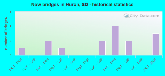
- New bridges - historical statistics
- 11900-1909
- 21920-1929
- 11930-1939
- 21960-1969
- 41970-1979
- 21980-1989
- 32000-2009

- Bridge Condition - Deck
- 18.2%Good
- 54.5%Satisfactory
- 27.3%Fair
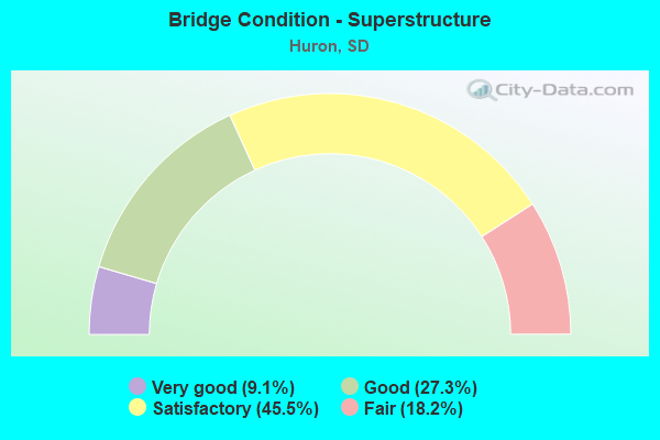
- Bridge Condition - Superstructure
- 9.1%Very good
- 27.3%Good
- 45.5%Satisfactory
- 18.2%Fair
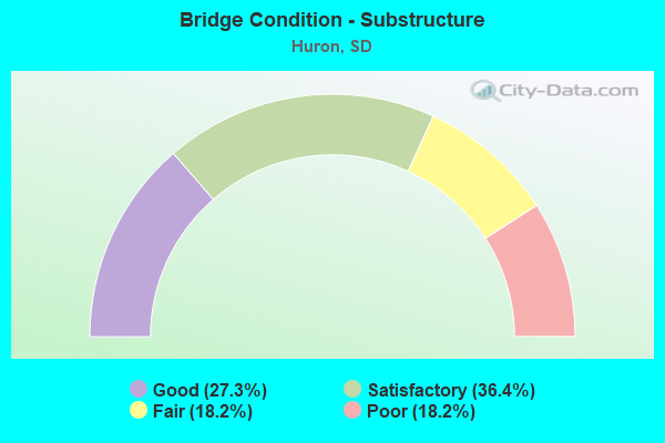
- Bridge Condition - Substructure
- 27.3%Good
- 36.4%Satisfactory
- 18.2%Fair
- 18.2%Poor
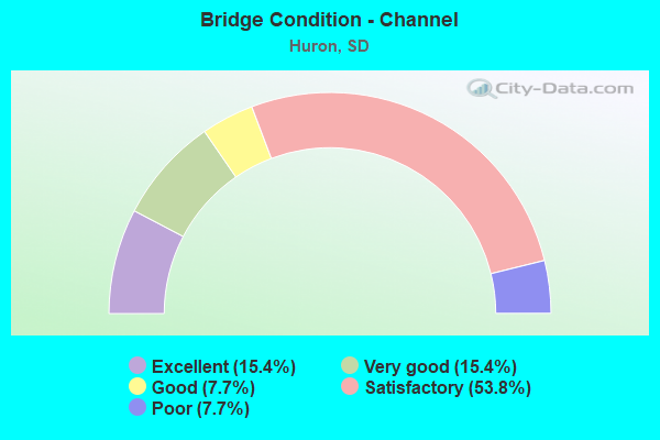
- Bridge Condition - Channel
- 15.4%Excellent
- 15.4%Very good
- 7.7%Good
- 53.8%Satisfactory
- 7.7%Poor
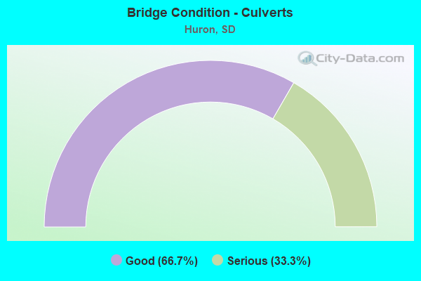
- Bridge Condition - Culverts
- 66.7%Good
- 33.3%Serious
Find on map >> Show street view
Structure Number: 3220197, Location: SW HURON - WEST PARK AVE (Lat: 44.346933, Lng: -98.254744), Route carried "on" structure: Bypass City street , Year Built: 2005, Status: Open, Structure Length: 1.08m (3.54ft), Average Daily Traffic: 700 (year 2019), Truck Traffic: 11%, Average Future Daily Traffic: 890 (year 2032), Design Load: HS 20+Mod, Features Intersected: TRIB STONY RUN CK, Facility Carried by Structure: 398 AVE
Minimum Vertical Clearance: 30+ m (98+ ft), Kilometerpoint: 0.000, Lanes on structure: 2, Owner: City or Municipal Highway Agency, Approaching Roadway Width: 13.4m (44.0ft), Skew: 1 degrees, Material/Design: Concrete continuous, Design/Construction: Culvert, Number Of Spans In Main Unit: 3, Length of Maximum Span: 3.5m (11.5ft)
Condition: Channel: Excellent, Culverts: Good, Operating Rating: 90.6 metric tons, Method Used To Determine Operating Rating: Load Factor (LF), Inventory Rating: 66.2 metric tons, Method Used To Determine Inventory Rating: Load Factor (LF), Structural Evaluation: Better than present minimum criteria, Waterway Adequacy: Superior to present desirable criteria, Approach Roadway Alignment: Superior to present desirable criteria, Designated Inspection Frequency: Every 48 months, Inspection Date: September 2020
Find on map >> Show street view
Structure Number: 322222, Location: 4S & 1.8W of Huron (Lat: 44.312719, Lng: -98.249522), Route carried "on" structure: County highway , Year Built: 1928, Status: Open, Structure Length: 1.71m (5.61ft), Average Daily Traffic: 56 (year 2019), Truck Traffic: 2%, Average Future Daily Traffic: 56 (year 2032), Features Intersected: Creek, Facility Carried by Structure: 212th Street
Minimum Vertical Clearance: 30+ m (98+ ft), Kilometerpoint: 0.000, Lanes on structure: 2, Owner: County Highway Agency, Approaching Roadway Width: 7.3m (24.0ft), Material/Design: Concrete continuous, Design/Construction: Slab, Number Of Spans In Main Unit: 5, Length of Maximum Span: 3.4m (11.2ft), Curb or Sidewalk Widths: Left: 0.2m (0.7ft), Right: 0.2m (0.7ft), Curb-To-Curb Width: 5.5m (18.0ft), Out-to-Out Width: 6.0m (19.7ft)
Condition: Deck: Fair, Superstructure: Fair, Substructure: Poor, Channel: Good, Operating Rating: 32.7 metric tons, Method Used To Determine Operating Rating: Field evaluation and documented engineering judgment, Inventory Rating: 24.5 metric tons, Method Used To Determine Inventory Rating: Field evaluation and documented engineering judgment, Structural Evaluation: Meets minimum limits, Deck Geometry: Meets minimum limits, Waterway Adequacy: Better than present minimum criteria, Approach Roadway Alignment: Better than present minimum criteria, Designated Inspection Frequency: Every 24 months, Inspection Date: July 2020, Deck Structure Type: Concrete Cast-file-Place, Wearing Surface/Protective System: Wearing Surface: Gravel
Find on map >> Show street view
Structure Number: 3231199, Location: SW CORNER OF HURON (Lat: 44.342333, Lng: -98.234217), Route carried "on" structure: Bypass City street , Year Built: 2005, Status: Open, Structure Length: 1.15m (3.77ft), Average Daily Traffic: 700 (year 2019), Truck Traffic: 11%, Average Future Daily Traffic: 890 (year 2032), Design Load: HS 20+Mod, Features Intersected: STONY RUN CK, Facility Carried by Structure: 210 ST (21ST SW)
Minimum Vertical Clearance: 30+ m (98+ ft), Kilometerpoint: 0.000, Lanes on structure: 5, Owner: City or Municipal Highway Agency, Approaching Roadway Width: 19.9m (65.3ft), Skew: 2 degrees, Material/Design: Concrete continuous, Design/Construction: Culvert, Number Of Spans In Main Unit: 3, Length of Maximum Span: 3.7m (12.1ft), Curb or Sidewalk Widths: Left: 1.8m (5.9ft), Right: 1.8m (5.9ft)
Condition: Channel: Excellent, Culverts: Good, Operating Rating: 90.6 metric tons, Method Used To Determine Operating Rating: Load Factor (LF), Inventory Rating: 66.2 metric tons, Method Used To Determine Inventory Rating: Load Factor (LF), Structural Evaluation: Better than present minimum criteria, Waterway Adequacy: Superior to present desirable criteria, Approach Roadway Alignment: Superior to present desirable criteria, Designated Inspection Frequency: Every 48 months, Inspection Date: September 2020
Find on map >> Show street view
Structure Number: 3239216, Location: 3.5 S JCT US 14 (Lat: 44.320108, Lng: -98.214189), Route carried "on" structure: State highway 37, Year Built: 1972, Status: Open, Structure Length: 5.22m (17.13ft), Average Daily Traffic: 2,306 (year 2021), Truck Traffic: 3%, Average Future Daily Traffic: 3,447 (year 2041), Design Load: HS 20, Features Intersected: STONY RUN CK
Minimum Vertical Clearance: 30+ m (98+ ft), Kilometerpoint: 199.913, Lanes on structure: 2, Base Highway Network: Yes, Owner: State Highway Agency, Approaching Roadway Width: 11.6m (38.1ft), Skew: 3 degrees, Material/Design: Steel continuous, Design/Construction: Stringer/Multi-beam, Number Of Spans In Main Unit: 3, Length of Maximum Span: 19.8m (65.0ft), Curb-To-Curb Width: 11.6m (38.1ft), Out-to-Out Width: 12.4m (40.7ft)
Condition: Deck: Satisfactory, Superstructure: Satisfactory, Substructure: Satisfactory, Channel: Very good, Operating Rating: 52.5 metric tons, Method Used To Determine Operating Rating: Load Factor (LF), Inventory Rating: 31.4 metric tons, Method Used To Determine Inventory Rating: Load Factor (LF), Structural Evaluation: Equal to present minimum criteria, Deck Geometry: Better than present minimum criteria, Waterway Adequacy: Equal to present desirable criteria, Approach Roadway Alignment: Equal to present desirable criteria, Designated Inspection Frequency: Every 24 months, Inspection Date: May 2020, Deck Structure Type: Concrete Cast-file-Place, Wearing Surface/Protective System: Wearing Surface: Epoxy Overlay, Membrane: Epoxy
Find on map >> Show street view
Structure Number: 3240216, Location: 3.5 S JCT US 14 (Lat: 44.319950, Lng: -98.213819), Route carried "on" structure: State highway 37, Year Built: 1970, Status: Open, Structure Length: 5.22m (17.13ft), Average Daily Traffic: 2,306 (year 2021), Truck Traffic: 3%, Average Future Daily Traffic: 3,447 (year 2041), Design Load: HS 20, Features Intersected: STONY RUN CK
Minimum Vertical Clearance: 30+ m (98+ ft), Kilometerpoint: 199.913, Lanes on structure: 2, Base Highway Network: Yes, Owner: State Highway Agency, Approaching Roadway Width: 11.6m (38.1ft), Skew: 3 degrees, Material/Design: Steel continuous, Design/Construction: Stringer/Multi-beam, Number Of Spans In Main Unit: 3, Length of Maximum Span: 19.8m (65.0ft), Curb-To-Curb Width: 11.6m (38.1ft), Out-to-Out Width: 12.4m (40.7ft)
Condition: Deck: Satisfactory, Superstructure: Satisfactory, Substructure: Satisfactory, Channel: Very good, Operating Rating: 52.5 metric tons, Method Used To Determine Operating Rating: Load Factor (LF), Inventory Rating: 31.4 metric tons, Method Used To Determine Inventory Rating: Load Factor (LF), Structural Evaluation: Equal to present minimum criteria, Deck Geometry: Better than present minimum criteria, Waterway Adequacy: Equal to present desirable criteria, Approach Roadway Alignment: Equal to present desirable criteria, Designated Inspection Frequency: Every 24 months, Inspection Date: May 2020, Deck Structure Type: Concrete Cast-file-Place, Wearing Surface/Protective System: Wearing Surface: Epoxy Overlay, Membrane: Epoxy
Find on map >> Show street view
Structure Number: 324317, Location: 1N & 0.3E of Huron (Lat: 44.385069, Lng: -98.209114), Route carried "on" structure: Other road , Year Built: 1924, Status: Posted for load, Structure Length: 0.70m (2.30ft), Average Daily Traffic: 56 (year 2019), Truck Traffic: 2%, Average Future Daily Traffic: 56 (year 2032), Features Intersected: Ravine Park Lake, Facility Carried by Structure: 15th Street NE
Minimum Vertical Clearance: 30+ m (98+ ft), Kilometerpoint: 0.000, Lanes on structure: 2, Owner: County Highway Agency, Approaching Roadway Width: 7.3m (24.0ft), Material/Design: Concrete continuous, Design/Construction: Culvert, Number Of Spans In Main Unit: 2, Length of Maximum Span: 3.0m (9.8ft), Curb-To-Curb Width: 7.8m (25.6ft), Out-to-Out Width: 8.2m (26.9ft)
Condition: Channel: Satisfactory, Culverts: Serious, Operating Rating: 26.1 metric tons, Method Used To Determine Operating Rating: Field evaluation and documented engineering judgment, Inventory Rating: 19.6 metric tons, Method Used To Determine Inventory Rating: Field evaluation and documented engineering judgment, Structural Evaluation: High priority of corrective action, Deck Geometry: Equal to present minimum criteria, Waterway Adequacy: Somewhat better than minimum adequacy, Approach Roadway Alignment: Equal to present minimum criteria, Bridge Posting: Required (Relationship of Operating Rating to Maximum Legal Load: 20.0 - 29.9% below), Length Of Structure Improvement: 1.22m (4.00ft), Designated Inspection Frequency: Every 24 months, Underwater Inspection Frequency: Every 60 months, Inspection Date: July 2020, Underwater Inspection Date: September 2018, Bridge Improvement Cost: $626,000, Roadway Improvement Cost: $30,000, Total Project Cost: $656,000 ( Estimate for 2020)
Find on map >> Show street view
Structure Number: 324618, Location: 0.5 E JCT SD 37 (Lat: 44.370442, Lng: -98.203258), Route carried "on" structure: US 14, Year Built: 1960, Status: Open, Structure Length: 3.23m (10.60ft), Average Daily Traffic: 2,391 (year 2021), Truck Traffic: 3%, Average Future Daily Traffic: 3,424 (year 2041), Design Load: H 20, Features Intersected: RAVINE LK
Minimum Vertical Clearance: 30+ m (98+ ft), Kilometerpoint: 557.187, Lanes on structure: 2, Base Highway Network: Yes, Owner: State Highway Agency, Approaching Roadway Width: 11.6m (38.1ft), Material/Design: Concrete continuous, Design/Construction: Slab, Number Of Spans In Main Unit: 3, Length of Maximum Span: 11.7m (38.4ft), Curb-To-Curb Width: 9.1m (29.9ft), Out-to-Out Width: 10.5m (34.4ft)
Condition: Deck: Satisfactory, Superstructure: Satisfactory, Substructure: Fair, Channel: Satisfactory, Operating Rating: 56.0 metric tons, Method Used To Determine Operating Rating: Load Factor (LF), Inventory Rating: 33.5 metric tons, Method Used To Determine Inventory Rating: Load Factor (LF), Structural Evaluation: Somewhat better than minimum adequacy, Deck Geometry: Meets minimum limits, Waterway Adequacy: Equal to present desirable criteria, Approach Roadway Alignment: Better than present minimum criteria, Designated Inspection Frequency: Every 24 months, Underwater Inspection Frequency: Every 60 months, Inspection Date: May 2020, Underwater Inspection Date: September 2018, Deck Structure Type: Concrete Cast-file-Place, Wearing Surface/Protective System: Wearing Surface: Low Slump Concrete, Membrane: Epoxy
Find on map >> Show street view
Structure Number: 3246181, Location: 0.5 E JCT SD 37 (Lat: 44.370283, Lng: -98.203264), Route carried "on" structure: US 14, Year Built: 1960, Status: Open, Structure Length: 3.23m (10.60ft), Average Daily Traffic: 2,391 (year 2021), Truck Traffic: 3%, Average Future Daily Traffic: 3,424 (year 2041), Design Load: H 20, Features Intersected: RAVINE LK
Minimum Vertical Clearance: 30+ m (98+ ft), Kilometerpoint: 557.187, Lanes on structure: 2, Base Highway Network: Yes, Owner: State Highway Agency, Approaching Roadway Width: 11.0m (36.1ft), Material/Design: Concrete continuous, Design/Construction: Slab, Number Of Spans In Main Unit: 3, Length of Maximum Span: 11.7m (38.4ft), Curb-To-Curb Width: 9.1m (29.9ft), Out-to-Out Width: 10.5m (34.4ft)
Condition: Deck: Fair, Superstructure: Fair, Substructure: Fair, Channel: Satisfactory, Operating Rating: 57.1 metric tons, Method Used To Determine Operating Rating: Load Factor (LF), Inventory Rating: 34.2 metric tons, Method Used To Determine Inventory Rating: Load Factor (LF), Structural Evaluation: Somewhat better than minimum adequacy, Deck Geometry: Meets minimum limits, Waterway Adequacy: Equal to present desirable criteria, Approach Roadway Alignment: Better than present minimum criteria, Designated Inspection Frequency: Every 24 months, Underwater Inspection Frequency: Every 60 months, Inspection Date: May 2020, Underwater Inspection Date: September 2018, Deck Structure Type: Concrete Cast-file-Place, Wearing Surface/Protective System: Wearing Surface: Low Slump Concrete, Membrane: Epoxy
Find on map >> Show street view
Structure Number: 3248185, Location: 3RD ST SE IN HURON (Lat: 44.363228, Lng: -98.199053), Route carried "on" structure: Business City street , Year Built: 1982, Status: Open, Structure Length: 7.25m (23.79ft), Average Daily Traffic: 4,828 (year 2019), Truck Traffic: 1%, Average Future Daily Traffic: 4,828 (year 2032), Design Load: HS 20, Features Intersected: JAMES RV, Facility Carried by Structure: THIRD STREET
Minimum Vertical Clearance: 30+ m (98+ ft), Kilometerpoint: 0.000, Lanes on structure: 2, Owner: City or Municipal Highway Agency, Approaching Roadway Width: 9.8m (32.2ft), Material/Design: Steel continuous, Design/Construction: Stringer/Multi-beam, Number Of Spans In Main Unit: 3, Length of Maximum Span: 27.7m (90.9ft), Curb or Sidewalk Widths: Left: 1.8m (5.9ft), Right: 0.0m, Curb-To-Curb Width: 9.8m (32.2ft), Out-to-Out Width: 12.3m (40.4ft)
Condition: Deck: Satisfactory, Superstructure: Satisfactory, Substructure: Good, Channel: Poor, Operating Rating: 59.0 metric tons, Method Used To Determine Operating Rating: Load Factor (LF), Inventory Rating: 38.1 metric tons, Method Used To Determine Inventory Rating: Load Factor (LF), Structural Evaluation: Equal to present minimum criteria, Deck Geometry: Meets minimum limits, Waterway Adequacy: Equal to present desirable criteria, Approach Roadway Alignment: Superior to present desirable criteria, Designated Inspection Frequency: Every 24 months, Underwater Inspection Frequency: Every 60 months, Inspection Date: September 2020, Underwater Inspection Date: September 2018, Deck Structure Type: Concrete Cast-file-Place, Wearing Surface/Protective System: Wearing Surface: Monolithic Concrete, Deck Protection: Epoxy Coated Reinforcing
Find on map >> Show street view
Structure Number: 32522, Location: 2S & 1.1E of Huron (Lat: 44.341642, Lng: -98.191411), Route carried "on" structure: County highway , Year Built: 1977, Status: Open, Structure Length: 10.85m (35.60ft), Average Daily Traffic: 56 (year 2019), Truck Traffic: 3%, Average Future Daily Traffic: 56 (year 2032), Design Load: HS 20+Mod, Features Intersected: James River, Facility Carried by Structure: 210th Street
Minimum Vertical Clearance: 30+ m (98+ ft), Kilometerpoint: 0.000, Lanes on structure: 2, Owner: County Highway Agency, Approaching Roadway Width: 11.0m (36.1ft), Material/Design: Steel continuous, Design/Construction: Stringer/Multi-beam, Number Of Spans In Main Unit: 5, Length of Maximum Span: 23.5m (77.1ft), Curb-To-Curb Width: 11.0m (36.1ft), Out-to-Out Width: 11.8m (38.7ft)
Condition: Deck: Good, Superstructure: Good, Substructure: Satisfactory, Channel: Satisfactory, Operating Rating: 55.2 metric tons, Method Used To Determine Operating Rating: Load Factor (LF), Inventory Rating: 33.0 metric tons, Method Used To Determine Inventory Rating: Load Factor (LF), Structural Evaluation: Equal to present minimum criteria, Deck Geometry: Superior to present desirable criteria, Waterway Adequacy: Superior to present desirable criteria, Approach Roadway Alignment: Superior to present desirable criteria, Designated Inspection Frequency: Every 24 months, Underwater Inspection Frequency: Every 60 months, Inspection Date: July 2020, Underwater Inspection Date: September 2018, Deck Structure Type: Concrete Cast-file-Place, Wearing Surface/Protective System: Wearing Surface: Bituminous
Find on map >> Show street view
Structure Number: 3270149, Location: 3E & 3.1N of Huron (Lat: 44.415789, Lng: -98.153875), Route carried "on" structure: County highway , Year Built: 1975, Status: Open, Structure Length: 9.88m (32.41ft), Average Daily Traffic: 163 (year 2019), Truck Traffic: 3%, Average Future Daily Traffic: 163 (year 2032), Design Load: HS 20, Features Intersected: James River, Facility Carried by Structure: 403rd Avenue
Minimum Vertical Clearance: 30+ m (98+ ft), Kilometerpoint: 0.000, Lanes on structure: 2, Owner: County Highway Agency, Approaching Roadway Width: 8.5m (27.9ft), Skew: 3 degrees, Material/Design: Steel continuous, Design/Construction: Stringer/Multi-beam, Number Of Spans In Main Unit: 3, Length of Maximum Span: 37.8m (124.0ft), Curb-To-Curb Width: 9.1m (29.9ft), Out-to-Out Width: 10.0m (32.8ft)
Condition: Deck: Satisfactory, Superstructure: Good, Substructure: Good, Channel: Satisfactory, Operating Rating: 32.7 metric tons, Method Used To Determine Operating Rating: Load and Resistance Factor (LRFR), Inventory Rating: 24.5 metric tons, Method Used To Determine Inventory Rating: Load and Resistance Factor (LRFR), Structural Evaluation: Equal to present minimum criteria, Deck Geometry: Equal to present minimum criteria, Waterway Adequacy: Equal to present desirable criteria, Approach Roadway Alignment: Equal to present minimum criteria, Designated Inspection Frequency: Every 24 months, Inspection Date: July 2020, Deck Structure Type: Concrete Cast-file-Place, Wearing Surface/Protective System: Wearing Surface: Monolithic Concrete
Find on map >> Show street view
Structure Number: 329516, Location: 5.5E & 2N of Huron (Lat: 44.399039, Lng: -98.103331), Route carried "on" structure: County highway , Year Built: 1930, Status: Posted for load, Structure Length: 0.67m (2.20ft), Average Daily Traffic: 39 (year 2019), Truck Traffic: 2%, Average Future Daily Traffic: 39 (year 2032), Features Intersected: Unnamed Creek, Facility Carried by Structure: 206th Street
Minimum Vertical Clearance: 30+ m (98+ ft), Kilometerpoint: 0.000, Lanes on structure: 2, Owner: County Highway Agency, Approaching Roadway Width: 6.1m (20.0ft), Material/Design: Steel, Design/Construction: Stringer/Multi-beam, Number Of Spans In Main Unit: 1, Length of Maximum Span: 6.4m (21.0ft), Curb or Sidewalk Widths: Left: 0.2m (0.7ft), Right: 0.2m (0.7ft), Curb-To-Curb Width: 6.1m (20.0ft), Out-to-Out Width: 6.6m (21.7ft)
Condition: Deck: Fair, Superstructure: Satisfactory, Substructure: Poor, Channel: Satisfactory, Operating Rating: 21.0 metric tons, Method Used To Determine Operating Rating: Field evaluation and documented engineering judgment, Inventory Rating: 12.6 metric tons, Method Used To Determine Inventory Rating: Field evaluation and documented engineering judgment, Structural Evaluation: Meets minimum limits, Deck Geometry: Somewhat better than minimum adequacy, Waterway Adequacy: Equal to present minimum criteria, Approach Roadway Alignment: Equal to present desirable criteria, Bridge Posting: Required (Relationship of Operating Rating to Maximum Legal Load: > 39.9% below), Length Of Structure Improvement: 0.91m (2.99ft), Designated Inspection Frequency: Every 24 months, Inspection Date: August 2020, Bridge Improvement Cost: $498,000, Roadway Improvement Cost: $30,000, Total Project Cost: $528,000 ( Estimate for 2020), Deck Structure Type: Concrete Cast-file-Place, Wearing Surface/Protective System: Wearing Surface: Gravel
Find on map >> Show street view
Structure Number: 50119165, Location: SD 38 & I 90 INTERCHANGE (Lat: 43.609181, Lng: -96.894361), Route carried "on" structure: Interstate 90, Year Built: 1989, Status: Open, Structure Length: 7.29m (23.92ft), Average Daily Traffic: 8,045 (year 2021), Truck Traffic: 19%, Average Future Daily Traffic: 12,108 (year 2041), Design Load: HS 20+Mod, Features Intersected: SD038
Minimum Vertical Clearance: 30+ m (98+ ft), Kilometerpoint: 628.095, Lanes on structure: 3, Lanes under structure: 2, Base Highway Network: Yes, Owner: State Highway Agency, Approaching Roadway Width: 14.6m (47.9ft), Skew: 3 degrees, Material/Design: Prestressed concrete continuous, Design/Construction: Stringer/Multi-beam, Number Of Spans In Main Unit: 3, Length of Maximum Span: 31.1m (102.0ft), Curb-To-Curb Width: 14.6m (47.9ft), Out-to-Out Width: 15.4m (50.5ft)
Condition: Deck: Satisfactory, Superstructure: Very good, Substructure: Satisfactory, Operating Rating: 78.1 metric tons, Method Used To Determine Operating Rating: Load Factor (LF), Inventory Rating: 46.8 metric tons, Method Used To Determine Inventory Rating: Load Factor (LF), Structural Evaluation: Equal to present minimum criteria, Deck Geometry: Meets minimum limits, Underclear: Equal to present minimum criteria, Approach Roadway Alignment: Equal to present desirable criteria, Designated Inspection Frequency: Every 24 months, Inspection Date: Febuary 2022, Deck Structure Type: Concrete Cast-file-Place, Wearing Surface/Protective System: Wearing Surface: Epoxy Overlay, Membrane: Epoxy, Deck Protection: Epoxy Coated Reinforcing
Find on map >> Show street view
Structure Number: 50120157, Location: 3E & 0.7S HARTFORD (Lat: 43.620169, Lng: -96.890561), Route carried "on" structure: County highway , Year Built: 2009, Status: Open, Structure Length: 1.74m (5.71ft), Average Daily Traffic: 92 (year 2021), Truck Traffic: 2%, Average Future Daily Traffic: 100 (year 2036), Design Load: HS 20+Mod, Features Intersected: TRIB TO SKUNK CK, Facility Carried by Structure: 466TH AVENUE
Minimum Vertical Clearance: 30+ m (98+ ft), Kilometerpoint: 0.000, Lanes on structure: 2, Owner: County Highway Agency, Approaching Roadway Width: 7.0m (23.0ft), Skew: 2 degrees, Material/Design: Prestressed concrete, Design/Construction: Tee Beam, Number Of Spans In Main Unit: 1, Length of Maximum Span: 16.8m (55.1ft), Curb-To-Curb Width: 8.6m (28.2ft), Out-to-Out Width: 9.4m (30.8ft)
Condition: Deck: Good, Superstructure: Good, Substructure: Good, Channel: Satisfactory, Operating Rating: 32.7 metric tons, Method Used To Determine Operating Rating: Field evaluation and documented engineering judgment, Inventory Rating: 19.6 metric tons, Method Used To Determine Inventory Rating: Field evaluation and documented engineering judgment, Structural Evaluation: Somewhat better than minimum adequacy, Deck Geometry: Better than present minimum criteria, Waterway Adequacy: Equal to present desirable criteria, Approach Roadway Alignment: Equal to present desirable criteria, Length Of Structure Improvement: 2.44m (8.01ft), Designated Inspection Frequency: Every 24 months, Inspection Date: July 2021, Bridge Improvement Cost: $359,000, Roadway Improvement Cost: $36,000, Total Project Cost: $577,000 ( Estimate for 2017), Deck Structure Type: Concrete Precast Panels, Wearing Surface/Protective System: Wearing Surface: Monolithic Concrete
Find on map >> Show street view
Structure Number: 3248184, Location: JERSEY AVE. (Lat: 44.364067, Lng: -98.199500), Route carried "under" structure: City street , Year Built: 1907, Structure Length: 0. m, Average Daily Traffic: 4,220 (year 1997), Truck Traffic: 1%, Features Intersected: JERSEY AVE., Facility Carried by Structure: CP/DM&E RR
Minimum Vertical Clearance: 4.57m (14.99ft), Kilometerpoint: 0.000, Lanes under structure: 2, Material/Design: Steel, Design/Construction: Stringer/Multi-beam, Length of Maximum Span: 29.0m (95.1ft)