Bridge Statistics for Kennebunk, Maine (ME)
Condition, Traffic, Stress, Structural Evaluation, Project Costs
- National Bridge Inventory (NBI) Statistics
- 16Number of bridges
- 95ft / 29.3mTotal length
- 202,875Total average daily traffic
- 18,868Total average daily truck traffic
- National Bridge Inventory (NBI) Registered Bridges for Kennebunk
- No street view available for this location
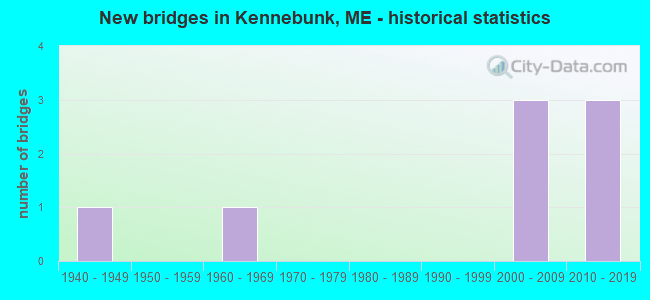
- New bridges - historical statistics
- 11940-1949
- 11960-1969
- 32000-2009
- 32010-2019


- Bridge Condition - Deck
- 37.5%Very good
- 37.5%Good
- 12.5%Satisfactory
- 12.5%Fair

- Bridge Condition - Superstructure
- 37.5%Very good
- 37.5%Good
- 25.0%Satisfactory

- Bridge Condition - Substructure
- 25.0%Very good
- 50.0%Good
- 12.5%Satisfactory
- 12.5%Poor

- Bridge Condition - Channel
- 20.0%Excellent
- 20.0%Very good
- 40.0%Satisfactory
- 20.0%Fair
Find on map >> Show street view
Structure Number: 1269, Location: 0.4 MI S JCT OF RTE 9 (Lat: 43.346119, Lng: -70.518869), Route carried "on" structure: City street , Year Built: 1945, Status: Posted for load, Structure Length: 0.76m (2.49ft), Average Daily Traffic: 662 (year 2016), Truck Traffic: 5%, Average Future Daily Traffic: 1,059 (year 2036), Features Intersected: BACK CREEK, Facility Carried by Structure: PARSONS BEACH ROAD
Minimum Vertical Clearance: 30+ m (98+ ft), Kilometerpoint: 3.042, Lanes on structure: 2, Owner: State Highway Agency, Approaching Roadway Width: 7.6m (24.9ft), Material/Design: Wood or Timber, Design/Construction: Stringer/Multi-beam, Number Of Spans In Main Unit: 1, Length of Maximum Span: 7.6m (24.9ft), Curb-To-Curb Width: 5.9m (19.4ft), Out-to-Out Width: 6.5m (21.3ft)
Condition: Deck: Satisfactory, Superstructure: Satisfactory, Substructure: Poor, Channel: Satisfactory, Operating Rating: 6.5 metric tons, Method Used To Determine Operating Rating: Load and Resistance Factor Rating (LRFR) rating reported by rating factor(RF) method using HL-93 loadings, Inventory Rating: 4.9 metric tons, Method Used To Determine Inventory Rating: Load and Resistance Factor Rating (LRFR) rating reported by rating factor(RF) method using HL-93 loadings, Structural Evaluation: High priority of corrective action, Deck Geometry: High priority of replacement, Waterway Adequacy: Equal to present desirable criteria, Approach Roadway Alignment: Equal to present desirable criteria, Bridge Posting: Required (Relationship of Operating Rating to Maximum Legal Load: 30.0 - 39.9% below), Designated Inspection Frequency: Every 24 months, Inspection Date: July 2021, Deck Structure Type: Wood or Timber
Find on map >> Show street view
Structure Number: 1329, Location: 0.174 mi W of Harrisecket (Lat: 43.381350, Lng: -70.575811), Route carried "on" structure: Alternate County highway 9, Year Built: 2001, Status: Open, Structure Length: 7.42m (24.34ft), Average Daily Traffic: 2,760 (year 2016), Truck Traffic: 5%, Average Future Daily Traffic: 3,864 (year 2036), Design Load: HL 93, Features Intersected: I-95
Minimum Vertical Clearance: 30+ m (98+ ft), Kilometerpoint: 9.012, Lanes on structure: 2, Lanes under structure: 6, Owner: State Toll Authority, Approaching Roadway Width: 9.8m (32.2ft), Skew: 1 degrees, Material/Design: Concrete continuous, Design/Construction: Stringer/Multi-beam, Number Of Spans In Main Unit: 2, Length of Maximum Span: 37.1m (121.7ft), Curb-To-Curb Width: 9.8m (32.2ft), Out-to-Out Width: 10.7m (35.1ft)
Condition: Deck: Good, Superstructure: Good, Substructure: Good, Operating Rating: 73.9 metric tons, Method Used To Determine Operating Rating: Load and Resistance Factor Rating (LRFR) rating reported by rating factor(RF) method using HL-93 loadings, Inventory Rating: 57.0 metric tons, Method Used To Determine Inventory Rating: Load and Resistance Factor Rating (LRFR) rating reported by rating factor(RF) method using HL-93 loadings, Structural Evaluation: Better than present minimum criteria, Deck Geometry: Meets minimum limits, Underclear: Equal to present minimum criteria, Approach Roadway Alignment: Equal to present desirable criteria, Designated Inspection Frequency: Every 24 months, Inspection Date: April 2021, Deck Structure Type: Concrete Cast-file-Place, Wearing Surface/Protective System: Wearing Surface: Bituminous, Membrane: Preformed Fabric, Deck Protection: Epoxy Coated Reinforcing
Find on map >> Show street view
Structure Number: 133, Location: 0.178 mi W Coventry Woods (Lat: 43.396519, Lng: -70.567319), Route carried "on" structure: County highway 99, Year Built: 2002, Status: Open, Structure Length: 5.69m (18.67ft), Average Daily Traffic: 2,890 (year 2016), Truck Traffic: 5%, Average Future Daily Traffic: 4,046 (year 2036), Design Load: HL 93, Features Intersected: I-95
Minimum Vertical Clearance: 30+ m (98+ ft), Kilometerpoint: 2.639, Lanes on structure: 2, Lanes under structure: 6, Owner: State Toll Authority, Approaching Roadway Width: 9.8m (32.2ft), Material/Design: Steel continuous, Design/Construction: Stringer/Multi-beam, Number Of Spans In Main Unit: 2, Length of Maximum Span: 28.4m (93.2ft), Curb-To-Curb Width: 9.8m (32.2ft), Out-to-Out Width: 10.7m (35.1ft)
Condition: Deck: Good, Superstructure: Good, Substructure: Good, Operating Rating: 36.9 metric tons, Method Used To Determine Operating Rating: Load and Resistance Factor Rating (LRFR) rating reported by rating factor(RF) method using HL-93 loadings, Inventory Rating: 28.5 metric tons, Method Used To Determine Inventory Rating: Load and Resistance Factor Rating (LRFR) rating reported by rating factor(RF) method using HL-93 loadings, Structural Evaluation: Better than present minimum criteria, Deck Geometry: Meets minimum limits, Underclear: Equal to present minimum criteria, Approach Roadway Alignment: Equal to present desirable criteria, Designated Inspection Frequency: Every 24 months, Inspection Date: April 2021, Deck Structure Type: Concrete Cast-file-Place, Wearing Surface/Protective System: Wearing Surface: Bituminous, Membrane: Preformed Fabric, Deck Protection: Epoxy Coated Reinforcing
Find on map >> Show street view
Structure Number: 2041, Location: 1.1MI N JCT RTE 9A & 35 (Lat: 43.402869, Lng: -70.526239), Route carried "on" structure: State highway 1, Year Built: 2016, Status: Open, Structure Length: 2.38m (7.81ft), Average Daily Traffic: 15,672 (year 2016), Truck Traffic: 5%, Average Future Daily Traffic: 21,941 (year 2036), Design Load: Greater than HL93, Features Intersected: KENNEBUNK RIVER
Minimum Vertical Clearance: 30+ m (98+ ft), Kilometerpoint: 42.937, Lanes on structure: 2, Base Highway Network: Yes, Owner: State Highway Agency, Approaching Roadway Width: 12.2m (40.0ft), Navigation Control: Yes ( Vertical Clearance: 2.4m (7.9ft), Horizontal Clearance: 3.0m (9.8ft)), Material/Design: Concrete, Design/Construction: Tee Beam, Number Of Spans In Main Unit: 1, Length of Maximum Span: 23.2m (76.1ft), Curb or Sidewalk Widths: Left: 1.5m (4.9ft), Right: 0.1m (0.3ft), Curb-To-Curb Width: 12.2m (40.0ft), Out-to-Out Width: 14.3m (46.9ft)
Condition: Deck: Very good, Superstructure: Very good, Substructure: Very good, Channel: Excellent, Operating Rating: 36.0 metric tons, Method Used To Determine Operating Rating: Load and Resistance Factor Rating (LRFR) rating reported by rating factor(RF) method using HL-93 loadings, Inventory Rating: 27.9 metric tons, Method Used To Determine Inventory Rating: Load and Resistance Factor Rating (LRFR) rating reported by rating factor(RF) method using HL-93 loadings, Structural Evaluation: Better than present minimum criteria, Deck Geometry: Somewhat better than minimum adequacy, Waterway Adequacy: Superior to present desirable criteria, Approach Roadway Alignment: Equal to present desirable criteria, Designated Inspection Frequency: Every 24 months, Inspection Date: July 2020, Deck Structure Type: Concrete Cast-file-Place, Wearing Surface/Protective System: Wearing Surface: Bituminous, Membrane: Preformed Fabric
Find on map >> Show street view
Structure Number: 2157, Location: 1.4 MI E OF WELLS (Lat: 43.351431, Lng: -70.518119), Route carried "on" structure: State highway 9, Year Built: 2013, Status: Open, Structure Length: 5.21m (17.09ft), Average Daily Traffic: 5,097 (year 2016), Truck Traffic: 5%, Average Future Daily Traffic: 7,136 (year 2036), Design Load: H 15, Features Intersected: MOUSAM RIVER
Minimum Vertical Clearance: 30+ m (98+ ft), Kilometerpoint: 33.281, Lanes on structure: 2, Owner: State Highway Agency, Approaching Roadway Width: 9.8m (32.2ft), Skew: 2 degrees, Navigation Control: Yes ( Vertical Clearance: 1.5m (4.9ft), Horizontal Clearance: 11.3m (37.1ft)), Material/Design: Prestressed concrete, Design/Construction: Slab, Number Of Spans In Main Unit: 3, Length of Maximum Span: 15.5m (50.9ft), Curb or Sidewalk Widths: Left: 0.0m, Right: 1.5m (4.9ft), Curb-To-Curb Width: 9.7m (31.8ft), Out-to-Out Width: 12.2m (40.0ft)
Condition: Deck: Very good, Superstructure: Very good, Substructure: Very good, Channel: Very good, Operating Rating: 68.4 metric tons, Method Used To Determine Operating Rating: Load and Resistance Factor Rating (LRFR) rating reported by rating factor(RF) method using HL-93 loadings, Inventory Rating: 52.5 metric tons, Method Used To Determine Inventory Rating: Load and Resistance Factor Rating (LRFR) rating reported by rating factor(RF) method using HL-93 loadings, Structural Evaluation: Equal to present desirable criteria, Deck Geometry: High priority of corrective action, Waterway Adequacy: Equal to present desirable criteria, Approach Roadway Alignment: Equal to present desirable criteria, Designated Inspection Frequency: Every 24 months, Underwater Inspection Frequency: Every 60 months, Inspection Date: July 2021, Underwater Inspection Date: May 2018, Deck Structure Type: Concrete Cast-file-Place, Wearing Surface/Protective System: Wearing Surface: Bituminous, Membrane: Preformed Fabric
Find on map >> Show street view
Structure Number: 2431, Location: 0.2 MI N 9A/99 (Lat: 43.385069, Lng: -70.542450), Route carried "on" structure: State highway 1, Year Built: 2011, Status: Open, Structure Length: 2.87m (9.42ft), Average Daily Traffic: 13,996 (year 2016), Truck Traffic: 5%, Average Future Daily Traffic: 19,594 (year 2036), Design Load: HS 25 or greater, Features Intersected: MOUSAM RIVER
Minimum Vertical Clearance: 30+ m (98+ ft), Kilometerpoint: 40.507, Lanes on structure: 3, Base Highway Network: Yes, Owner: State Highway Agency, Approaching Roadway Width: 13.7m (44.9ft), Material/Design: Concrete, Design/Construction: Stringer/Multi-beam, Number Of Spans In Main Unit: 1, Length of Maximum Span: 27.4m (89.9ft), Curb or Sidewalk Widths: Left: 1.5m (4.9ft), Right: 1.5m (4.9ft), Curb-To-Curb Width: 13.7m (44.9ft), Out-to-Out Width: 16.5m (54.1ft)
Condition: Deck: Very good, Superstructure: Very good, Substructure: Good, Channel: Satisfactory, Operating Rating: 63.2 metric tons, Method Used To Determine Operating Rating: Load and Resistance Factor Rating (LRFR) rating reported by rating factor(RF) method using HL-93 loadings, Inventory Rating: 48.6 metric tons, Method Used To Determine Inventory Rating: Load and Resistance Factor Rating (LRFR) rating reported by rating factor(RF) method using HL-93 loadings, Structural Evaluation: Better than present minimum criteria, Deck Geometry: Somewhat better than minimum adequacy, Waterway Adequacy: Equal to present desirable criteria, Approach Roadway Alignment: Equal to present desirable criteria, Designated Inspection Frequency: Every 24 months, Inspection Date: July 2021, Deck Structure Type: Concrete Cast-file-Place, Wearing Surface/Protective System: Wearing Surface: Bituminous, Membrane: Preformed Fabric
Find on map >> Show street view
Structure Number: 3597, Location: 1 E JCT US 1 (Lat: 43.383469, Lng: -70.528419), Route carried "on" structure: Alternate County highway 9, Year Built: 2004, Status: Open, Structure Length: 1.30m (4.27ft), Average Daily Traffic: 8,500 (year 2016), Truck Traffic: 5%, Average Future Daily Traffic: 11,900 (year 2036), Design Load: HS 20, Features Intersected: BOSTON AND MAINE RAILROA
Minimum Vertical Clearance: 30+ m (98+ ft), Kilometerpoint: 13.293, Lanes on structure: 2, Owner: Railroad, Maintenance Responsibility: State Highway Agency, Approaching Roadway Width: 9.8m (32.2ft), Material/Design: Prestressed concrete, Design/Construction: Slab, Number Of Spans In Main Unit: 1, Length of Maximum Span: 12.3m (40.4ft), Curb or Sidewalk Widths: Left: 1.5m (4.9ft), Right: 0.1m (0.3ft), Curb-To-Curb Width: 11.4m (37.4ft), Out-to-Out Width: 12.2m (40.0ft)
Condition: Deck: Good, Superstructure: Good, Substructure: Good, Operating Rating: 80.0 metric tons, Method Used To Determine Operating Rating: Load and Resistance Factor Rating (LRFR) rating reported by rating factor(RF) method using HL-93 loadings, Inventory Rating: 61.9 metric tons, Method Used To Determine Inventory Rating: Load and Resistance Factor Rating (LRFR) rating reported by rating factor(RF) method using HL-93 loadings, Structural Evaluation: Better than present minimum criteria, Deck Geometry: Meets minimum limits, Underclear: Meets minimum limits, Approach Roadway Alignment: Equal to present desirable criteria, Designated Inspection Frequency: Every 24 months, Inspection Date: July 2021, Deck Structure Type: Concrete Precast Panels, Wearing Surface/Protective System: Wearing Surface: Bituminous, Membrane: Preformed Fabric, Deck Protection: Other
Find on map >> Show street view
Structure Number: 6049, Location: 0.2 MI NE OF RTE 9A & 35 (Lat: 43.378811, Lng: -70.505150), Route carried "on" structure: City street , Year Built: 1967, Status: Open, Structure Length: 3.64m (11.94ft), Average Daily Traffic: 2,680 (year 2016), Truck Traffic: 5%, Average Future Daily Traffic: 3,752 (year 2036), Design Load: H 20, Features Intersected: KENNEBUNK RIVER, Facility Carried by Structure: DURRELLS BRIDGE RD
Minimum Vertical Clearance: 30+ m (98+ ft), Kilometerpoint: 0.354, Lanes on structure: 2, Owner: State Highway Agency, Approaching Roadway Width: 7.9m (25.9ft), Skew: 2 degrees, Navigation Control: Yes ( Vertical Clearance: 1.8m (5.9ft), Horizontal Clearance: 11.3m (37.1ft)), Material/Design: Steel continuous, Design/Construction: Stringer/Multi-beam, Number Of Spans In Main Unit: 3, Length of Maximum Span: 12.2m (40.0ft), Curb or Sidewalk Widths: Left: 0.5m (1.6ft), Right: 0.5m (1.6ft), Curb-To-Curb Width: 8.5m (27.9ft), Out-to-Out Width: 10.2m (33.5ft)
Condition: Deck: Fair, Superstructure: Satisfactory, Substructure: Satisfactory, Channel: Fair, Operating Rating: 35.6 metric tons, Method Used To Determine Operating Rating: Load and Resistance Factor Rating (LRFR) rating reported by rating factor(RF) method using HL-93 loadings, Inventory Rating: 27.5 metric tons, Method Used To Determine Inventory Rating: Load and Resistance Factor Rating (LRFR) rating reported by rating factor(RF) method using HL-93 loadings, Structural Evaluation: Equal to present minimum criteria, Deck Geometry: Meets minimum limits, Waterway Adequacy: Superior to present desirable criteria, Approach Roadway Alignment: Better than present minimum criteria, Designated Inspection Frequency: Every 24 months, Inspection Date: December 2021, Deck Structure Type: Concrete Cast-file-Place, Wearing Surface/Protective System: Wearing Surface: Bituminous, Membrane: Built-up
Find on map >> Show street view
Location: 0.175 mi W of Spencer Dr (Lat: 43.322828, Lng: -70.608261), Route carried "on" structure: Alternate State highway 32310, Structure Length: 0. m, Average Daily Traffic: 7,704 (year 2014), Truck Traffic: 9%, Features Intersected: I-95 (NB), Facility Carried by Structure: SANFORD RD/RTE 9 &
Minimum Vertical Clearance: 4.70m (15.42ft), Kilometerpoint: 24.317, Lanes on structure: 6, Length of Maximum Span: 0.0m
Find on map >> Show street view
Location: 0.296 mi W of Spencer Dr (Lat: 43.324958, Lng: -70.607067), Route carried "on" structure: Alternate State highway 42110, Structure Length: 0. m, Average Daily Traffic: 22,400 (year 2014), Truck Traffic: 11%, Features Intersected: I-95 (NB), Facility Carried by Structure: WELLS INTERCHANGE
Minimum Vertical Clearance: 4.49m (14.73ft), Kilometerpoint: 30.642, Lanes on structure: 2, Toll: On Interstate toll segment, Length of Maximum Span: 0.0m
Find on map >> Show street view
Location: 0.084 mi SE of Lindsey Rd (Lat: 43.333711, Lng: -70.602331), Route carried "on" structure: Alternate State highway 52110, Structure Length: 0. m, Average Daily Traffic: 23,310 (year 2014), Truck Traffic: 11%, Features Intersected: BURNT MILL ROAD, Facility Carried by Structure: I-95
Minimum Vertical Clearance: 5.11m (16.77ft), Kilometerpoint: 31.688, Lanes on structure: 4, Toll: On Interstate toll segment, Length of Maximum Span: 0.0m
Find on map >> Show street view
Location: 0.135 mi W of Ledgewood (Lat: 43.357253, Lng: -70.589314), Route carried "on" structure: Alternate State highway 72110, Structure Length: 0. m, Average Daily Traffic: 23,310 (year 2014), Truck Traffic: 11%, Features Intersected: COLES HILL RD, Facility Carried by Structure: I-95
Minimum Vertical Clearance: 4.34m (14.24ft), Kilometerpoint: 34.488, Lanes on structure: 4, Toll: On Interstate toll segment, Length of Maximum Span: 0.0m
Find on map >> Show street view
Location: 0.174 mi W of Harrisecket (Lat: 43.381347, Lng: -70.575811), Route carried "on" structure: Alternate State highway 92110, Structure Length: 0. m, Average Daily Traffic: 23,310 (year 2014), Truck Traffic: 11%, Features Intersected: HIGH ST./RTE. 9A, Facility Carried by Structure: I-95
Minimum Vertical Clearance: 4.34m (14.24ft), Kilometerpoint: 37.321, Lanes on structure: 4, Toll: On Interstate toll segment, Length of Maximum Span: 0.0m
Find on map >> Show street view
Location: 0.178 mi W Coventry Woods (Lat: 43.396519, Lng: -70.567314), Route carried "on" structure: Bypass State highway 2110, Structure Length: 0. m, Average Daily Traffic: 23,310 (year 2014), Truck Traffic: 11%, Features Intersected: CAT MOUSAM/RTE 99, Facility Carried by Structure: I-95
Minimum Vertical Clearance: 4.42m (14.50ft), Kilometerpoint: 38.978, Lanes on structure: 4, Toll: On Interstate toll segment, Length of Maximum Span: 0.0m
Find on map >> Show street view
Location: 0.193 mi W of Spencer Dr (Lat: 43.322889, Lng: -70.608478), Route carried "on" structure: Ramp County highway 92310, Structure Length: 0. m, Average Daily Traffic: 7,704 (year 2014), Truck Traffic: 9%, Features Intersected: I-95 (SB), Facility Carried by Structure: SANFORD RD/RTE 9 &
Minimum Vertical Clearance: 4.70m (15.42ft), Kilometerpoint: 24.285, Lanes on structure: 6, Length of Maximum Span: 0.0m
Find on map >> Show street view
Location: 0.305 mi W of Spencer Dr (Lat: 43.324986, Lng: -70.607308), Route carried "on" structure: ServiceCounty highway 2110, Structure Length: 0. m, Average Daily Traffic: 19,570 (year 2014), Truck Traffic: 11%, Features Intersected: I-95(SB), Facility Carried by Structure: WELLS INTER.
Minimum Vertical Clearance: 4.11m (13.48ft), Kilometerpoint: 457.295, Lanes on structure: 2, Toll: On Interstate toll segment, Length of Maximum Span: 0.0m