Bridge Statistics for Kettleman City, California (CA)
Condition, Traffic, Stress, Structural Evaluation, Project Costs
- National Bridge Inventory (NBI) Statistics
- 15Number of bridges
- 256ft / 77.7mTotal length
- 133,060Total average daily traffic
- 37,390Total average daily truck traffic
- National Bridge Inventory (NBI) Registered Bridges for Kettleman City
- No street view available for this location
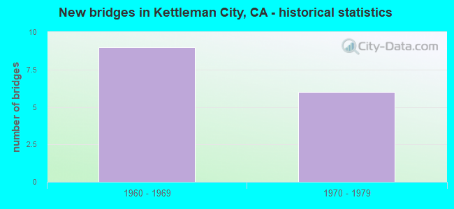
- New bridges - historical statistics
- 91960-1969
- 61970-1979
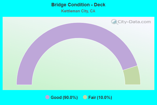
- Bridge Condition - Deck
- 90.0%Good
- 10.0%Fair
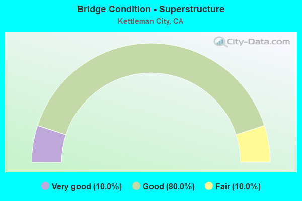
- Bridge Condition - Superstructure
- 10.0%Very good
- 80.0%Good
- 10.0%Fair
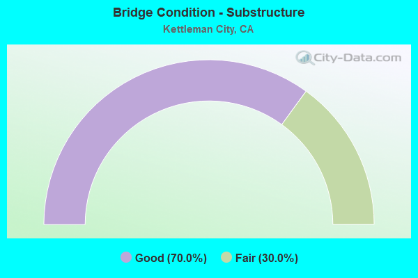
- Bridge Condition - Substructure
- 70.0%Good
- 30.0%Fair
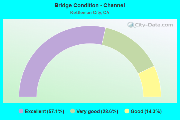
- Bridge Condition - Channel
- 57.1%Excellent
- 28.6%Very good
- 14.3%Good
Find on map >> Show street view
Structure Number: 45C0124, Location: 1.7 mi S plymouth Ave (Lat: 36.048031, Lng: -120.003631), Route carried "on" structure: County highway , Year Built: 1965, Status: Open, Structure Length: 5.94m (19.49ft), Average Daily Traffic: 100 (year 2017), Truck Traffic: 15%, Average Future Daily Traffic: 120 (year 2029), Design Load: HS 20, Features Intersected: San Luis Canal, Facility Carried by Structure: 30th Ave
Minimum Vertical Clearance: 30+ m (98+ ft), Kilometerpoint: 272.565, Lanes on structure: 2, Owner: Bureau of Reclamation, Maintenance Responsibility: Local Agency, Approaching Roadway Width: 9.8m (32.2ft), Skew: 2 degrees, Material/Design: Prestressed concrete, Design/Construction: Stringer/Multi-beam, Number Of Spans In Main Unit: 2, Length of Maximum Span: 29.0m (95.1ft), Curb-To-Curb Width: 9.8m (32.2ft), Out-to-Out Width: 9.9m (32.5ft)
Condition: Deck: Good, Superstructure: Very good, Substructure: Good, Channel: Excellent, Operating Rating: 99.0 metric tons, Method Used To Determine Operating Rating: Load Factor (LF), Inventory Rating: 32.4 metric tons, Method Used To Determine Inventory Rating: Load Factor (LF), Structural Evaluation: Better than present minimum criteria, Deck Geometry: Equal to present desirable criteria, Waterway Adequacy: Equal to present desirable criteria, Approach Roadway Alignment: Equal to present desirable criteria, Designated Inspection Frequency: Every 48 months, Underwater Inspection Frequency: Every 60 months, Inspection Date: May 2020, Underwater Inspection Date: May 2018, Deck Structure Type: Concrete Cast-file-Place
Find on map >> Show street view
Structure Number: 45C0125, Location: 2.0 MI W OF CA 41 (Lat: 36.036253, Lng: -119.993469), Route carried "on" structure: County highway , Year Built: 1965, Status: Open, Structure Length: 5.48m (17.98ft), Average Daily Traffic: 200 (year 2015), Average Future Daily Traffic: 230 (year 2036), Design Load: HS 20, Features Intersected: San Luis Canal, Facility Carried by Structure: Quail Ave
Minimum Vertical Clearance: 30+ m (98+ ft), Kilometerpoint: 274.206, Lanes on structure: 2, Owner: Bureau of Reclamation, Maintenance Responsibility: State Agenciy, Approaching Roadway Width: 8.5m (27.9ft), Skew: 2 degrees, Material/Design: Prestressed concrete, Design/Construction: Stringer/Multi-beam, Number Of Spans In Main Unit: 2, Length of Maximum Span: 26.5m (86.9ft), Curb-To-Curb Width: 9.8m (32.2ft), Out-to-Out Width: 9.9m (32.5ft)
Condition: Deck: Good, Superstructure: Good, Substructure: Good, Channel: Excellent, Operating Rating: 87.2 metric tons, Method Used To Determine Operating Rating: Load Factor (LF), Inventory Rating: 32.4 metric tons, Method Used To Determine Inventory Rating: Load Factor (LF), Structural Evaluation: Better than present minimum criteria, Deck Geometry: Better than present minimum criteria, Waterway Adequacy: Equal to present desirable criteria, Approach Roadway Alignment: Equal to present desirable criteria, Designated Inspection Frequency: Every 48 months, Underwater Inspection Frequency: Every 60 months, Inspection Date: May 2020, Underwater Inspection Date: May 2018, Deck Structure Type: Concrete Cast-file-Place
Find on map >> Show street view
Structure Number: 45 0068, Location: 06-KIN-005-14.55 (Lat: 35.958519, Lng: -119.937103), Route carried "on" structure: County highway , Year Built: 1971, Status: Open, Structure Length: 8.66m (28.41ft), Average Daily Traffic: 500 (year 2004), Truck Traffic: 20%, Average Future Daily Traffic: 798 (year 2039), Design Load: HS 20, Features Intersected: INTERSTATE 5, Facility Carried by Structure: 25TH AVE OC
Minimum Vertical Clearance: 30+ m (98+ ft), Kilometerpoint: 0.000, Lanes on structure: 2, Lanes under structure: 4, Owner: State Highway Agency, Approaching Roadway Width: 12.2m (40.0ft), Material/Design: Prestressed concrete continuous, Design/Construction: Box Beam or Girders - Multiple, Number Of Spans In Main Unit: 2, Length of Maximum Span: 43.3m (142.1ft), Curb-To-Curb Width: 9.7m (31.8ft), Out-to-Out Width: 10.4m (34.1ft)
Condition: Deck: Fair, Superstructure: Good, Substructure: Good, Operating Rating: 56.4 metric tons, Method Used To Determine Operating Rating: Load and Resistance Factor Rating (LRFR) rating reported by rating factor(RF) method using HL-93 loadings, Inventory Rating: 26.2 metric tons, Method Used To Determine Inventory Rating: Load and Resistance Factor Rating (LRFR) rating reported by rating factor(RF) method using HL-93 loadings, Structural Evaluation: Equal to present minimum criteria, Deck Geometry: Equal to present minimum criteria, Underclear: Meets minimum limits, Approach Roadway Alignment: Equal to present minimum criteria, Designated Inspection Frequency: Every 24 months, Inspection Date: December 2020, Deck Structure Type: Concrete Cast-file-Place
Find on map >> Show street view
Structure Number: 45 0069L, Location: 06-KIN-005-14.92 (Lat: 35.962950, Lng: -119.941311), Route carried "on" structure: Interstate 5, Year Built: 1967, Status: Open, Structure Length: 5.79m (19.00ft), Average Daily Traffic: 14,500 (year 2009), Truck Traffic: 30%, Average Future Daily Traffic: 41,572 (year 2042), Design Load: HS 20+Mod, Features Intersected: CALIFORNIA AQUEDUCT
Minimum Vertical Clearance: 30+ m (98+ ft), Kilometerpoint: 14.920, Lanes on structure: 2, Base Highway Network: Yes (, Subroute: 1), Owner: State Highway Agency, Approaching Roadway Width: 11.9m (39.0ft), Skew: 3 degrees, Material/Design: Concrete continuous, Design/Construction: Box Beam or Girders - Multiple, Number Of Spans In Main Unit: 2, Length of Maximum Span: 29.0m (95.1ft), Curb-To-Curb Width: 11.9m (39.0ft), Out-to-Out Width: 12.8m (42.0ft)
Condition: Deck: Good, Superstructure: Good, Substructure: Fair, Channel: Excellent, Operating Rating: 55.4 metric tons, Method Used To Determine Operating Rating: Load and Resistance Factor Rating (LRFR) rating reported by rating factor(RF) method using HL-93 loadings, Inventory Rating: 40.8 metric tons, Method Used To Determine Inventory Rating: Load and Resistance Factor Rating (LRFR) rating reported by rating factor(RF) method using HL-93 loadings, Structural Evaluation: Somewhat better than minimum adequacy, Deck Geometry: Equal to present minimum criteria, Waterway Adequacy: Equal to present desirable criteria, Approach Roadway Alignment: Equal to present desirable criteria, Designated Inspection Frequency: Every 24 months, Underwater Inspection Frequency: Every 72 months, Inspection Date: December 2020, Underwater Inspection Date: Febuary 2019, Deck Structure Type: Concrete Cast-file-Place, Wearing Surface/Protective System: Wearing Surface: Integral Concrete
Find on map >> Show street view
Structure Number: 45 0069R, Location: 06-KIN-005-14.92 (Lat: 35.963278, Lng: -119.941161), Route carried "on" structure: Interstate 5, Year Built: 1967, Status: Open, Structure Length: 5.79m (19.00ft), Average Daily Traffic: 14,500 (year 2009), Truck Traffic: 31%, Average Future Daily Traffic: 23,358 (year 2042), Design Load: HS 20+Mod, Features Intersected: CALIFORNIA AQUEDUCT
Minimum Vertical Clearance: 30+ m (98+ ft), Kilometerpoint: 14.920, Lanes on structure: 2, Base Highway Network: Yes (, Subroute: 1), Owner: State Highway Agency, Approaching Roadway Width: 11.9m (39.0ft), Skew: 3 degrees, Material/Design: Concrete continuous, Design/Construction: Box Beam or Girders - Multiple, Number Of Spans In Main Unit: 2, Length of Maximum Span: 29.0m (95.1ft), Curb-To-Curb Width: 11.9m (39.0ft), Out-to-Out Width: 12.8m (42.0ft)
Condition: Deck: Good, Superstructure: Fair, Substructure: Fair, Channel: Excellent, Operating Rating: 55.4 metric tons, Method Used To Determine Operating Rating: Load and Resistance Factor Rating (LRFR) rating reported by rating factor(RF) method using HL-93 loadings, Inventory Rating: 42.4 metric tons, Method Used To Determine Inventory Rating: Load and Resistance Factor Rating (LRFR) rating reported by rating factor(RF) method using HL-93 loadings, Structural Evaluation: Somewhat better than minimum adequacy, Deck Geometry: Equal to present minimum criteria, Waterway Adequacy: Equal to present desirable criteria, Approach Roadway Alignment: Equal to present desirable criteria, Designated Inspection Frequency: Every 24 months, Underwater Inspection Frequency: Every 72 months, Inspection Date: December 2020, Underwater Inspection Date: Febuary 2019, Deck Structure Type: Concrete Cast-file-Place, Wearing Surface/Protective System: Wearing Surface: Bituminous
Find on map >> Show street view
Structure Number: 45 0070L, Location: 06-KIN-005-16.57 (Lat: 35.981306, Lng: -119.960128), Route carried "on" structure: Interstate 5, Year Built: 1971, Status: Open, Structure Length: 8.84m (29.00ft), Average Daily Traffic: 17,000 (year 2004), Truck Traffic: 31%, Average Future Daily Traffic: 22,420 (year 2039), Design Load: HS 20+Mod, Features Intersected: SR 41
Minimum Vertical Clearance: 30+ m (98+ ft), Kilometerpoint: 16.570, Lanes on structure: 2, Lanes under structure: 4, Base Highway Network: Yes (, Subroute: 1), Owner: State Highway Agency, Approaching Roadway Width: 11.9m (39.0ft), Skew: 3 degrees, Material/Design: Prestressed concrete continuous, Design/Construction: Box Beam or Girders - Multiple, Number Of Spans In Main Unit: 2, Length of Maximum Span: 48.8m (160.1ft), Curb-To-Curb Width: 11.9m (39.0ft), Out-to-Out Width: 12.5m (41.0ft)
Condition: Deck: Good, Superstructure: Good, Substructure: Good, Operating Rating: 89.4 metric tons, Method Used To Determine Operating Rating: Load Factor (LF), Inventory Rating: 32.4 metric tons, Method Used To Determine Inventory Rating: Load Factor (LF), Structural Evaluation: Better than present minimum criteria, Deck Geometry: Equal to present minimum criteria, Underclear: Better than present minimum criteria, Approach Roadway Alignment: Equal to present desirable criteria, Designated Inspection Frequency: Every 24 months, Inspection Date: December 2020, Deck Structure Type: Concrete Cast-file-Place, Wearing Surface/Protective System: Wearing Surface: Bituminous
Find on map >> Show street view
Structure Number: 45 0070R, Location: 06-KIN-005-16.57 (Lat: 35.981631, Lng: -119.959961), Route carried "on" structure: Interstate 5, Year Built: 1971, Status: Open, Structure Length: 9.17m (30.09ft), Average Daily Traffic: 17,000 (year 2004), Truck Traffic: 31%, Average Future Daily Traffic: 22,420 (year 2039), Design Load: HS 20+Mod, Features Intersected: SR 41
Minimum Vertical Clearance: 30+ m (98+ ft), Kilometerpoint: 16.570, Lanes on structure: 2, Lanes under structure: 4, Base Highway Network: Yes (, Subroute: 1), Owner: State Highway Agency, Approaching Roadway Width: 11.9m (39.0ft), Skew: 3 degrees, Material/Design: Prestressed concrete continuous, Design/Construction: Box Beam or Girders - Multiple, Number Of Spans In Main Unit: 2, Length of Maximum Span: 47.5m (155.8ft), Curb-To-Curb Width: 11.9m (39.0ft), Out-to-Out Width: 12.5m (41.0ft)
Condition: Deck: Good, Superstructure: Good, Substructure: Good, Operating Rating: 88.8 metric tons, Method Used To Determine Operating Rating: Load Factor (LF), Inventory Rating: 32.4 metric tons, Method Used To Determine Inventory Rating: Load Factor (LF), Structural Evaluation: Better than present minimum criteria, Deck Geometry: Equal to present minimum criteria, Underclear: Equal to present minimum criteria, Approach Roadway Alignment: Equal to present desirable criteria, Designated Inspection Frequency: Every 24 months, Inspection Date: December 2020, Deck Structure Type: Concrete Cast-file-Place, Wearing Surface/Protective System: Wearing Surface: Bituminous
Find on map >> Show street view
Structure Number: 45 0071, Location: 06-KIN-005-19.05 (Lat: 36.008611, Lng: -119.989456), Route carried "on" structure: County highway , Year Built: 1969, Status: Open, Structure Length: 14.02m (46.00ft), Average Daily Traffic: 100 (year 2004), Truck Traffic: 20%, Average Future Daily Traffic: 159 (year 2039), Design Load: HS 20+Mod, Features Intersected: INTERSTATE 5, Facility Carried by Structure: MILHAM AVENUE
Minimum Vertical Clearance: 30+ m (98+ ft), Kilometerpoint: 0.000, Lanes on structure: 2, Lanes under structure: 4, Owner: State Highway Agency, Approaching Roadway Width: 10.4m (34.1ft), Material/Design: Prestressed concrete continuous, Design/Construction: Box Beam or Girders - Multiple, Number Of Spans In Main Unit: 3, Length of Maximum Span: 51.2m (168.0ft), Curb-To-Curb Width: 9.8m (32.2ft), Out-to-Out Width: 10.4m (34.1ft)
Condition: Deck: Good, Superstructure: Good, Substructure: Good, Operating Rating: 50.9 metric tons, Method Used To Determine Operating Rating: Load and Resistance Factor Rating (LRFR) rating reported by rating factor(RF) method using HL-93 loadings, Inventory Rating: 35.3 metric tons, Method Used To Determine Inventory Rating: Load and Resistance Factor Rating (LRFR) rating reported by rating factor(RF) method using HL-93 loadings, Structural Evaluation: Better than present minimum criteria, Deck Geometry: Equal to present desirable criteria, Underclear: Meets minimum limits, Approach Roadway Alignment: Better than present minimum criteria, Designated Inspection Frequency: Every 24 months, Inspection Date: December 2020, Deck Structure Type: Concrete Cast-file-Place
Find on map >> Show street view
Structure Number: 45 0088, Location: 06-KIN-041-16.99 (Lat: 35.991894, Lng: -119.959558), Route carried "on" structure: State highway 41, Year Built: 1967, Year Reconstructed: 1987, Status: Open, Structure Length: 6.79m (22.28ft), Average Daily Traffic: 7,900 (year 2009), Truck Traffic: 13%, Average Future Daily Traffic: 9,754 (year 2042), Design Load: HS 20+Mod, Features Intersected: CALIFORNIA AQUEDUCT
Minimum Vertical Clearance: 30+ m (98+ ft), Kilometerpoint: 16.990, Lanes on structure: 2, Base Highway Network: Yes (, Subroute: 1), Owner: State Highway Agency, Approaching Roadway Width: 13.4m (44.0ft), Skew: 4 degrees, Material/Design: Concrete continuous, Design/Construction: Box Beam or Girders - Multiple, Number Of Spans In Main Unit: 2, Length of Maximum Span: 35.6m (116.8ft), Curb-To-Curb Width: 12.9m (42.3ft), Out-to-Out Width: 13.8m (45.3ft)
Condition: Deck: Good, Superstructure: Good, Substructure: Good, Channel: Very good, Operating Rating: 54.1 metric tons, Method Used To Determine Operating Rating: Assigned rating based on Load Factor Design (LFD) reported in metric tons, Inventory Rating: 32.4 metric tons, Method Used To Determine Inventory Rating: Assigned rating based on Load Factor Design (LFD) reported in metric tons, Structural Evaluation: Better than present minimum criteria, Deck Geometry: Somewhat better than minimum adequacy, Waterway Adequacy: Equal to present desirable criteria, Approach Roadway Alignment: Equal to present desirable criteria, Designated Inspection Frequency: Every 24 months, Underwater Inspection Frequency: Every 72 months, Inspection Date: December 2020, Underwater Inspection Date: Febuary 2019, Deck Structure Type: Concrete Cast-file-Place
Find on map >> Show street view
Structure Number: 45 0089, Location: 06-KIN-041-17.06 (Lat: 35.992972, Lng: -119.959553), Route carried "on" structure: State highway 41, Year Built: 1960, Status: Open, Structure Length: 0.66m (2.17ft), Average Daily Traffic: 6,700 (year 2009), Truck Traffic: 13%, Average Future Daily Traffic: 9,774 (year 2042), Features Intersected: ARROYO ROBADOR
Minimum Vertical Clearance: 30+ m (98+ ft), Kilometerpoint: 17.060, Lanes on structure: 2, Base Highway Network: Yes (, Subroute: 1), Owner: State Highway Agency, Approaching Roadway Width: 9.8m (32.2ft), Skew: 1 degrees, Material/Design: Concrete continuous, Design/Construction: Culvert, Number Of Spans In Main Unit: 2, Length of Maximum Span: 3.3m (10.8ft)
Condition: Channel: Good, Culverts: Good, Operating Rating: 54.1 metric tons, Method Used To Determine Operating Rating: Field evaluation and documented engineering judgment, Inventory Rating: 32.4 metric tons, Method Used To Determine Inventory Rating: Field evaluation and documented engineering judgment, Structural Evaluation: Better than present minimum criteria, Waterway Adequacy: Better than present minimum criteria, Approach Roadway Alignment: Equal to present desirable criteria, Designated Inspection Frequency: Every 24 months, Inspection Date: December 2020
Find on map >> Show street view
Structure Number: 45C0126, Location: BTWN I-5 & KETTLEMAN CITY (Lat: 36.009858, Lng: -119.974806), Route carried "on" structure: County highway , Year Built: 1965, Status: Open, Structure Length: 6.58m (21.59ft), Average Daily Traffic: 50 (year 2018), Truck Traffic: 15%, Average Future Daily Traffic: 126 (year 2042), Design Load: HS 20, Features Intersected: CALIFORNIA AQUEDUCT, Facility Carried by Structure: MILHAM AVE
Minimum Vertical Clearance: 30+ m (98+ ft), Kilometerpoint: 0.000, Lanes on structure: 2, Owner: State Agenciy, Maintenance Responsibility: County Highway Agency, Approaching Roadway Width: 6.7m (22.0ft), Skew: 4 degrees, Material/Design: Concrete continuous, Design/Construction: Tee Beam, Number Of Spans In Main Unit: 3, Length of Maximum Span: 25.0m (82.0ft), Curb or Sidewalk Widths: Left: 0.6m (2.0ft), Right: 0.6m (2.0ft), Curb-To-Curb Width: 8.5m (27.9ft), Out-to-Out Width: 9.9m (32.5ft)
Condition: Deck: Good, Superstructure: Good, Substructure: Fair, Channel: Very good, Operating Rating: 42.4 metric tons, Method Used To Determine Operating Rating: Load and Resistance Factor Rating (LRFR) rating reported by rating factor(RF) method using HL-93 loadings, Inventory Rating: 32.7 metric tons, Method Used To Determine Inventory Rating: Load and Resistance Factor Rating (LRFR) rating reported by rating factor(RF) method using HL-93 loadings, Structural Evaluation: Somewhat better than minimum adequacy, Deck Geometry: Better than present minimum criteria, Waterway Adequacy: Equal to present desirable criteria, Approach Roadway Alignment: Equal to present desirable criteria, Designated Inspection Frequency: Every 24 months, Underwater Inspection Frequency: Every 72 months, Inspection Date: October 2020, Underwater Inspection Date: Febuary 2019, Deck Structure Type: Concrete Cast-file-Place
Find on map >> Show street view
Structure Number: 45 0068, Location: 06-KIN-005-14.55 (Lat: 35.958519, Lng: -119.937103), Route carried "under" structure: Interstate 5, Year Built: 1971, Structure Length: 0. m, Average Daily Traffic: 29,000 (year 2009), Truck Traffic: 31%, Features Intersected: INTERSTATE 5
Minimum Vertical Clearance: 4.97m (16.31ft), Kilometerpoint: 14.550, Lanes on structure: 2, Lanes under structure: 4, Material/Design: Prestressed concrete continuous, Design/Construction: Box Beam or Girders - Multiple, Length of Maximum Span: 43.3m (142.1ft)
Find on map >> Show street view
Structure Number: 45 0070L, Location: 06-KIN-005-16.57 (Lat: 35.981306, Lng: -119.960128), Route carried "under" structure: State highway 41, Year Built: 1971, Structure Length: 0. m, Average Daily Traffic: 3,105 (year 2009), Truck Traffic: 16%, Features Intersected: SR 41, Facility Carried by Structure: INTERSTATE 5 SB
Minimum Vertical Clearance: 4.90m (16.08ft), Kilometerpoint: 16.270, Lanes on structure: 2, Lanes under structure: 4, Material/Design: Prestressed concrete continuous, Design/Construction: Box Beam or Girders - Multiple, Length of Maximum Span: 48.8m (160.1ft)
Find on map >> Show street view
Structure Number: 45 0070R, Location: 06-KIN-005-16.57 (Lat: 35.981631, Lng: -119.959961), Route carried "under" structure: State highway 41, Year Built: 1971, Structure Length: 0. m, Average Daily Traffic: 3,105 (year 2004), Truck Traffic: 16%, Features Intersected: SR 41, Facility Carried by Structure: INTERSTATE 5 NB
Minimum Vertical Clearance: 4.87m (15.98ft), Kilometerpoint: 16.270, Lanes on structure: 2, Lanes under structure: 4, Material/Design: Prestressed concrete continuous, Design/Construction: Box Beam or Girders - Multiple, Length of Maximum Span: 47.5m (155.8ft)
Find on map >> Show street view
Structure Number: 45 0071, Location: 06-KIN-005-19.05 (Lat: 36.008611, Lng: -119.989456), Route carried "under" structure: Interstate 5, Year Built: 1969, Structure Length: 0. m, Average Daily Traffic: 19,300 (year 2004), Truck Traffic: 31%, Features Intersected: INTERSTATE 5, Facility Carried by Structure: MILHAM AVENUE
Minimum Vertical Clearance: 5.18m (16.99ft), Kilometerpoint: 19.050, Lanes on structure: 2, Lanes under structure: 4, Material/Design: Prestressed concrete continuous, Design/Construction: Box Beam or Girders - Multiple, Length of Maximum Span: 51.2m (168.0ft)