Bridge Statistics for Kingman, Arizona (AZ)
Condition, Traffic, Stress, Structural Evaluation, Project Costs
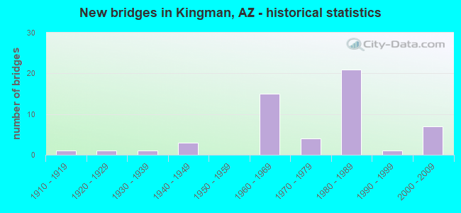
- New bridges - historical statistics
- 11910-1919
- 11920-1929
- 11930-1939
- 31940-1949
- 151960-1969
- 41970-1979
- 211980-1989
- 11990-1999
- 72000-2009
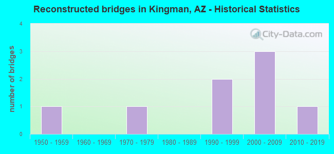
- Reconstructed bridges - Historical Statistics
- 11950-1959
- 01960-1969
- 11970-1979
- 01980-1989
- 21990-1999
- 32000-2009
- 12010-2019
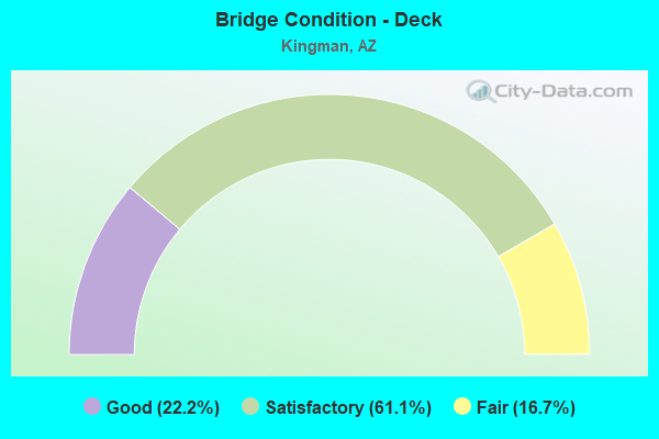
- Bridge Condition - Deck
- 22.2%Good
- 61.1%Satisfactory
- 16.7%Fair
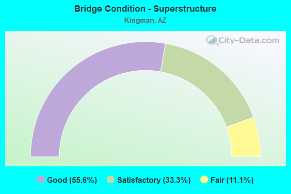
- Bridge Condition - Superstructure
- 55.6%Good
- 33.3%Satisfactory
- 11.1%Fair
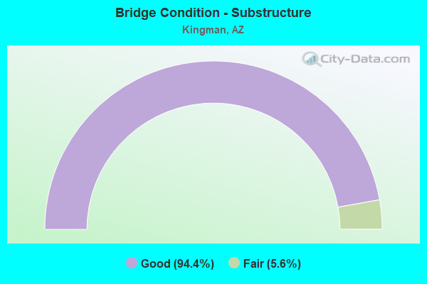
- Bridge Condition - Substructure
- 94.4%Good
- 5.6%Fair
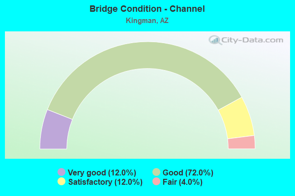
- Bridge Condition - Channel
- 12.0%Very good
- 72.0%Good
- 12.0%Satisfactory
- 4.0%Fair
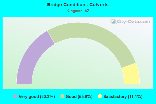
- Bridge Condition - Culverts
- 33.3%Very good
- 55.6%Good
- 11.1%Satisfactory
Find on map >> Show street view
Structure Number: 1068, Location: 5.9 mi E Jct SR 84 (Lat: 32.830400, Lng: -112.032500), Route carried "on" structure: Interstate 8, Year Built: 1962, Status: Open, Structure Length: 2.74m (8.99ft), Average Daily Traffic: 2,871 (year 2018), Truck Traffic: 17%, Average Future Daily Traffic: 2,881 (year 2038), Design Load: HS 20, Features Intersected: Smith Road
Minimum Vertical Clearance: 30+ m (98+ ft), Kilometerpoint: 253.552, Lanes on structure: 2, Lanes under structure: 2, Owner: State Highway Agency, Approaching Roadway Width: 11.6m (38.1ft), Material/Design: Concrete continuous, Design/Construction: Slab, Number Of Spans In Main Unit: 3, Length of Maximum Span: 10.1m (33.1ft), Curb-To-Curb Width: 12.2m (40.0ft), Out-to-Out Width: 13.2m (43.3ft)
Condition: Deck: Fair, Superstructure: Fair, Substructure: Good, Operating Rating: 37.2 metric tons, Method Used To Determine Operating Rating: Load Factor (LF), Inventory Rating: 21.8 metric tons, Method Used To Determine Inventory Rating: Load Factor (LF), Structural Evaluation: Somewhat better than minimum adequacy, Deck Geometry: Better than present minimum criteria, Underclear: High priority of replacement, Approach Roadway Alignment: Equal to present desirable criteria, Length Of Structure Improvement: 3.54m (11.61ft), Designated Inspection Frequency: Every 24 months, Inspection Date: March 2020, Total Project Cost: $1,000 ( Estimate for 2018), Deck Structure Type: Concrete Cast-file-Place, Wearing Surface/Protective System: Wearing Surface: Monolithic Concrete
Find on map >> Show street view
Structure Number: 1173, Location: 3.4 mi E Jct SR 66 (Lat: 35.206800, Lng: -113.952600), Route carried "on" structure: Interstate 40, Year Built: 1967, Status: Open, Structure Length: 5.00m (16.40ft), Average Daily Traffic: 12,939 (year 2019), Truck Traffic: 27%, Average Future Daily Traffic: 12,949 (year 2039), Design Load: HS 20, Features Intersected: Rattlesnake Wash
Minimum Vertical Clearance: 30+ m (98+ ft), Kilometerpoint: 91.572, Lanes on structure: 2, Owner: State Highway Agency, Approaching Roadway Width: 11.6m (38.1ft), Skew: 2 degrees, Material/Design: Concrete continuous, Design/Construction: Slab, Number Of Spans In Main Unit: 5, Length of Maximum Span: 10.7m (35.1ft), Curb-To-Curb Width: 11.6m (38.1ft), Out-to-Out Width: 12.4m (40.7ft)
Condition: Deck: Satisfactory, Superstructure: Satisfactory, Substructure: Good, Channel: Good, Operating Rating: 64.4 metric tons, Method Used To Determine Operating Rating: Load Factor (LF), Inventory Rating: 38.1 metric tons, Method Used To Determine Inventory Rating: Load Factor (LF), Structural Evaluation: Equal to present minimum criteria, Deck Geometry: Equal to present minimum criteria, Waterway Adequacy: Equal to present minimum criteria, Approach Roadway Alignment: Equal to present desirable criteria, Designated Inspection Frequency: Every 24 months, Inspection Date: October 2020, Deck Structure Type: Concrete Cast-file-Place, Wearing Surface/Protective System: Wearing Surface: Bituminous
Find on map >> Show street view
Structure Number: 1174, Location: 3.4 mi E Jct SR 66 (Lat: 35.207200, Lng: -113.952600), Route carried "on" structure: Interstate 40, Year Built: 1967, Status: Open, Structure Length: 5.00m (16.40ft), Average Daily Traffic: 12,939 (year 2019), Truck Traffic: 27%, Average Future Daily Traffic: 12,949 (year 2039), Design Load: HS 20, Features Intersected: Rattlesnake Wash
Minimum Vertical Clearance: 30+ m (98+ ft), Kilometerpoint: 91.572, Lanes on structure: 2, Owner: State Highway Agency, Approaching Roadway Width: 11.6m (38.1ft), Skew: 2 degrees, Material/Design: Concrete continuous, Design/Construction: Slab, Number Of Spans In Main Unit: 5, Length of Maximum Span: 10.7m (35.1ft), Curb-To-Curb Width: 11.6m (38.1ft), Out-to-Out Width: 12.4m (40.7ft)
Condition: Deck: Fair, Superstructure: Satisfactory, Substructure: Good, Channel: Good, Operating Rating: 64.4 metric tons, Method Used To Determine Operating Rating: Load Factor (LF), Inventory Rating: 39.0 metric tons, Method Used To Determine Inventory Rating: Load Factor (LF), Structural Evaluation: Equal to present minimum criteria, Deck Geometry: Equal to present minimum criteria, Waterway Adequacy: Equal to present minimum criteria, Approach Roadway Alignment: Equal to present desirable criteria, Designated Inspection Frequency: Every 24 months, Inspection Date: October 2020, Deck Structure Type: Concrete Cast-file-Place, Wearing Surface/Protective System: Wearing Surface: Bituminous
Find on map >> Show street view
Structure Number: 1249, Location: 6.2 mi E Jct SR 66 (Lat: 35.197400, Lng: -113.905900), Route carried "on" structure: County highway , Year Built: 1967, Year Reconstructed: 2017, Status: Open, Structure Length: 7.83m (25.69ft), Average Daily Traffic: 397 (year 2017), Truck Traffic: 10%, Average Future Daily Traffic: 407 (year 2037), Design Load: HS 20, Features Intersected: I-40, Facility Carried by Structure: DW Ranch Road
Minimum Vertical Clearance: 30+ m (98+ ft), Kilometerpoint: 0.000, Lanes on structure: 2, Lanes under structure: 4, Owner: State Highway Agency, Approaching Roadway Width: 8.5m (27.9ft), Material/Design: Steel continuous, Design/Construction: Stringer/Multi-beam, Number Of Spans In Main Unit: 4, Length of Maximum Span: 24.7m (81.0ft), Curb-To-Curb Width: 13.7m (44.9ft), Out-to-Out Width: 14.6m (47.9ft)
Condition: Deck: Good, Superstructure: Satisfactory, Substructure: Good, Operating Rating: 56.2 metric tons, Method Used To Determine Operating Rating: Load Factor (LF), Inventory Rating: 33.6 metric tons, Method Used To Determine Inventory Rating: Load Factor (LF), Structural Evaluation: Equal to present minimum criteria, Deck Geometry: Superior to present desirable criteria, Underclear: Meets minimum limits, Approach Roadway Alignment: Equal to present minimum criteria, Designated Inspection Frequency: Every 24 months, Inspection Date: October 2020, Deck Structure Type: Concrete Cast-file-Place, Wearing Surface/Protective System: Wearing Surface: Monolithic Concrete
Find on map >> Show street view
Structure Number: 1357, Location: 18.5 mi W Jct US 93 (Lat: 35.217000, Lng: -114.011300), Route carried "on" structure: Interstate 40, Year Built: 1969, Year Reconstructed: 2012, Status: Open, Structure Length: 6.49m (21.29ft), Average Daily Traffic: 12,939 (year 2019), Truck Traffic: 27%, Average Future Daily Traffic: 12,949 (year 2039), Design Load: HS 20, Features Intersected: SR 66
Minimum Vertical Clearance: 30+ m (98+ ft), Kilometerpoint: 86.180, Lanes on structure: 2, Lanes under structure: 4, Owner: State Highway Agency, Approaching Roadway Width: 11.6m (38.1ft), Skew: 3 degrees, Material/Design: Concrete continuous, Design/Construction: Box Beam or Girders - Single/Spread, Number Of Spans In Main Unit: 2, Length of Maximum Span: 32.3m (106.0ft), Curb-To-Curb Width: 11.6m (38.1ft), Out-to-Out Width: 12.4m (40.7ft)
Condition: Deck: Satisfactory, Superstructure: Good, Substructure: Good, Operating Rating: 59.9 metric tons, Method Used To Determine Operating Rating: Load Factor (LF), Inventory Rating: 36.3 metric tons, Method Used To Determine Inventory Rating: Load Factor (LF), Structural Evaluation: Better than present minimum criteria, Deck Geometry: Equal to present minimum criteria, Underclear: Meets minimum limits, Approach Roadway Alignment: Equal to present desirable criteria, Designated Inspection Frequency: Every 24 months, Inspection Date: October 2020, Deck Structure Type: Concrete Cast-file-Place, Wearing Surface/Protective System: Wearing Surface: Monolithic Concrete
Find on map >> Show street view
Structure Number: 1359, Location: 0.2 mi E Jct SR 66 (Lat: 35.217100, Lng: -114.007700), Route carried "on" structure: Interstate 40, Year Built: 1969, Year Reconstructed: 2012, Status: Open, Structure Length: 10.37m (34.02ft), Average Daily Traffic: 14,647 (year 2021), Truck Traffic: 30%, Average Future Daily Traffic: 14,657 (year 2041), Design Load: HS 20, Features Intersected: SFRR @ Kingman
Minimum Vertical Clearance: 30+ m (98+ ft), Kilometerpoint: 86.534, Lanes on structure: 3, Lanes under structure: 3, Owner: State Highway Agency, Approaching Roadway Width: 16.8m (55.1ft), Skew: 4 degrees, Material/Design: Steel continuous, Design/Construction: Stringer/Multi-beam, Number Of Spans In Main Unit: 5, Length of Maximum Span: 22.9m (75.1ft), Curb-To-Curb Width: 16.9m (55.4ft), Out-to-Out Width: 17.7m (58.1ft)
Condition: Deck: Good, Superstructure: Satisfactory, Substructure: Good, Channel: Very good, Operating Rating: 60.8 metric tons, Method Used To Determine Operating Rating: Load Factor (LF), Inventory Rating: 36.3 metric tons, Method Used To Determine Inventory Rating: Load Factor (LF), Structural Evaluation: Equal to present minimum criteria, Deck Geometry: Equal to present minimum criteria, Underclear: Equal to present desirable criteria, Waterway Adequacy: Equal to present desirable criteria, Approach Roadway Alignment: Equal to present desirable criteria, Designated Inspection Frequency: Every 24 months, Inspection Date: August 2021, Deck Structure Type: Concrete Cast-file-Place, Wearing Surface/Protective System: Wearing Surface: Monolithic Concrete
Find on map >> Show street view
Structure Number: 136, Location: 0.2 mi E Jct SR 66 (Lat: 35.217400, Lng: -114.007400), Route carried "on" structure: Interstate 40, Year Built: 1969, Year Reconstructed: 2012, Status: Open, Structure Length: 10.74m (35.24ft), Average Daily Traffic: 10,600 (year 2021), Truck Traffic: 30%, Average Future Daily Traffic: 10,610 (year 2041), Design Load: HS 20, Features Intersected: SFRR @ Kingman
Minimum Vertical Clearance: 30+ m (98+ ft), Kilometerpoint: 86.534, Lanes on structure: 2, Lanes under structure: 2, Owner: State Highway Agency, Approaching Roadway Width: 11.6m (38.1ft), Skew: 4 degrees, Material/Design: Steel continuous, Design/Construction: Stringer/Multi-beam, Number Of Spans In Main Unit: 5, Length of Maximum Span: 27.4m (89.9ft), Curb-To-Curb Width: 11.6m (38.1ft), Out-to-Out Width: 12.4m (40.7ft)
Condition: Deck: Good, Superstructure: Satisfactory, Substructure: Good, Channel: Very good, Operating Rating: 56.2 metric tons, Method Used To Determine Operating Rating: Load Factor (LF), Inventory Rating: 33.6 metric tons, Method Used To Determine Inventory Rating: Load Factor (LF), Structural Evaluation: Equal to present minimum criteria, Deck Geometry: Equal to present minimum criteria, Underclear: Superior to present desirable criteria, Waterway Adequacy: Equal to present desirable criteria, Approach Roadway Alignment: Equal to present desirable criteria, Designated Inspection Frequency: Every 24 months, Inspection Date: August 2021, Deck Structure Type: Concrete Cast-file-Place, Wearing Surface/Protective System: Wearing Surface: Monolithic Concrete
Find on map >> Show street view
Structure Number: 1835, Location: 4.7 mi W Jct SR 66 (Lat: 35.194444, Lng: -114.066667), Route carried "on" structure: Interstate 40, Year Built: 1980, Status: Open, Structure Length: 4.33m (14.21ft), Average Daily Traffic: 7,615 (year 2019), Truck Traffic: 45%, Average Future Daily Traffic: 7,625 (year 2039), Design Load: HS 20, Features Intersected: US 93 & SB 40
Minimum Vertical Clearance: 30+ m (98+ ft), Kilometerpoint: 78.600, Lanes on structure: 2, Lanes under structure: 6, Owner: State Highway Agency, Approaching Roadway Width: 11.6m (38.1ft), Material/Design: Prestressed concrete, Design/Construction: Box Beam or Girders - Single/Spread, Number Of Spans In Main Unit: 1, Length of Maximum Span: 42.4m (139.1ft), Curb-To-Curb Width: 12.8m (42.0ft), Out-to-Out Width: 13.8m (45.3ft)
Condition: Deck: Satisfactory, Superstructure: Good, Substructure: Good, Operating Rating: 70.8 metric tons, Method Used To Determine Operating Rating: Load Factor (LF), Inventory Rating: 41.7 metric tons, Method Used To Determine Inventory Rating: Load Factor (LF), Structural Evaluation: Better than present minimum criteria, Deck Geometry: Equal to present desirable criteria, Underclear: High priority of corrective action, Approach Roadway Alignment: Equal to present desirable criteria, Designated Inspection Frequency: Every 24 months, Inspection Date: October 2020, Deck Structure Type: Concrete Cast-file-Place, Wearing Surface/Protective System: Wearing Surface: Monolithic Concrete
Find on map >> Show street view
Structure Number: 1836, Location: 4.7 mi W Jct SR 66 (Lat: 35.194444, Lng: -114.066667), Route carried "on" structure: Interstate 40, Year Built: 1980, Status: Open, Structure Length: 4.33m (14.21ft), Average Daily Traffic: 7,615 (year 2019), Truck Traffic: 45%, Average Future Daily Traffic: 7,625 (year 2039), Design Load: HS 20, Features Intersected: US 93 / SB 40
Minimum Vertical Clearance: 30+ m (98+ ft), Kilometerpoint: 78.600, Lanes on structure: 2, Lanes under structure: 6, Owner: State Highway Agency, Approaching Roadway Width: 11.6m (38.1ft), Material/Design: Prestressed concrete, Design/Construction: Box Beam or Girders - Single/Spread, Number Of Spans In Main Unit: 1, Length of Maximum Span: 42.4m (139.1ft), Curb-To-Curb Width: 12.8m (42.0ft), Out-to-Out Width: 13.8m (45.3ft)
Condition: Deck: Satisfactory, Superstructure: Good, Substructure: Good, Operating Rating: 70.8 metric tons, Method Used To Determine Operating Rating: Load Factor (LF), Inventory Rating: 41.7 metric tons, Method Used To Determine Inventory Rating: Load Factor (LF), Structural Evaluation: Better than present minimum criteria, Deck Geometry: Equal to present desirable criteria, Underclear: High priority of corrective action, Approach Roadway Alignment: Equal to present desirable criteria, Designated Inspection Frequency: Every 24 months, Inspection Date: October 2020, Deck Structure Type: Concrete Cast-file-Place, Wearing Surface/Protective System: Wearing Surface: Monolithic Concrete
Find on map >> Show street view
Structure Number: 1837, Location: 3.9 mi W Jct SR 66 (Lat: 35.202800, Lng: -114.063800), Route carried "on" structure: Interstate 40, Year Built: 1980, Status: Open, Structure Length: 9.85m (32.32ft), Average Daily Traffic: 19,864 (year 2019), Truck Traffic: 18%, Average Future Daily Traffic: 19,874 (year 2039), Design Load: HS 20, Features Intersected: Clack Cyn Wash & Road
Minimum Vertical Clearance: 30+ m (98+ ft), Kilometerpoint: 80.017, Lanes on structure: 2, Lanes under structure: 2, Owner: State Highway Agency, Approaching Roadway Width: 11.6m (38.1ft), Skew: 4 degrees, Material/Design: Prestressed concrete continuous, Design/Construction: Box Beam or Girders - Single/Spread, Number Of Spans In Main Unit: 2, Length of Maximum Span: 48.8m (160.1ft), Curb-To-Curb Width: 12.8m (42.0ft), Out-to-Out Width: 13.8m (45.3ft)
Condition: Deck: Satisfactory, Superstructure: Good, Substructure: Good, Channel: Good, Operating Rating: 68.0 metric tons, Method Used To Determine Operating Rating: Load Factor (LF), Inventory Rating: 40.8 metric tons, Method Used To Determine Inventory Rating: Load Factor (LF), Structural Evaluation: Better than present minimum criteria, Deck Geometry: Equal to present desirable criteria, Underclear: Superior to present desirable criteria, Waterway Adequacy: Equal to present desirable criteria, Approach Roadway Alignment: Equal to present desirable criteria, Designated Inspection Frequency: Every 24 months, Inspection Date: October 2020, Deck Structure Type: Concrete Cast-file-Place, Wearing Surface/Protective System: Wearing Surface: Monolithic Concrete
Find on map >> Show street view
Structure Number: 1839, Location: 3.5 mi W Jct SR 66 (Lat: 35.207300, Lng: -114.059800), Route carried "on" structure: Interstate 40, Year Built: 1980, Status: Open, Structure Length: 4.11m (13.48ft), Average Daily Traffic: 19,864 (year 2019), Truck Traffic: 18%, Average Future Daily Traffic: 19,874 (year 2039), Design Load: HS 20, Features Intersected: White Cliff Rd
Minimum Vertical Clearance: 30+ m (98+ ft), Kilometerpoint: 80.612, Lanes on structure: 2, Lanes under structure: 2, Owner: State Highway Agency, Approaching Roadway Width: 11.6m (38.1ft), Skew: 2 degrees, Material/Design: Prestressed concrete, Design/Construction: Box Beam or Girders - Single/Spread, Number Of Spans In Main Unit: 1, Length of Maximum Span: 40.2m (131.9ft), Curb-To-Curb Width: 12.8m (42.0ft), Out-to-Out Width: 13.8m (45.3ft)
Condition: Deck: Satisfactory, Superstructure: Good, Substructure: Good, Operating Rating: 62.6 metric tons, Method Used To Determine Operating Rating: Load Factor (LF), Inventory Rating: 34.5 metric tons, Method Used To Determine Inventory Rating: Load Factor (LF), Structural Evaluation: Better than present minimum criteria, Underclear: Superior to present desirable criteria, Approach Roadway Alignment: Equal to present desirable criteria, Designated Inspection Frequency: Every 24 months, Inspection Date: October 2020, Deck Structure Type: Concrete Cast-file-Place, Wearing Surface/Protective System: Wearing Surface: Monolithic Concrete
Find on map >> Show street view
Structure Number: 1841, Location: 1.85 mi W Jct 66 (Lat: 35.216667, Lng: -114.036111), Route carried "on" structure: Interstate 40, Year Built: 1980, Status: Open, Structure Length: 4.33m (14.21ft), Average Daily Traffic: 19,864 (year 2019), Truck Traffic: 18%, Average Future Daily Traffic: 19,874 (year 2039), Design Load: HS 20, Features Intersected: Stockton Hill Road
Minimum Vertical Clearance: 30+ m (98+ ft), Kilometerpoint: 83.123, Lanes on structure: 2, Lanes under structure: 6, Owner: State Highway Agency, Approaching Roadway Width: 11.6m (38.1ft), Material/Design: Prestressed concrete, Design/Construction: Box Beam or Girders - Single/Spread, Number Of Spans In Main Unit: 1, Length of Maximum Span: 42.4m (139.1ft), Curb-To-Curb Width: 12.8m (42.0ft), Out-to-Out Width: 13.8m (45.3ft)
Condition: Deck: Satisfactory, Superstructure: Good, Substructure: Good, Operating Rating: 70.8 metric tons, Method Used To Determine Operating Rating: Load Factor (LF), Inventory Rating: 41.7 metric tons, Method Used To Determine Inventory Rating: Load Factor (LF), Structural Evaluation: Better than present minimum criteria, Deck Geometry: Equal to present desirable criteria, Underclear: Meets minimum limits, Approach Roadway Alignment: Equal to present desirable criteria, Designated Inspection Frequency: Every 24 months, Inspection Date: October 2020, Deck Structure Type: Concrete Cast-file-Place, Wearing Surface/Protective System: Wearing Surface: Monolithic Concrete
Find on map >> Show street view
Structure Number: 1842, Location: 1.85 mi W Jct 66 (Lat: 35.216667, Lng: -114.036111), Route carried "on" structure: Interstate 40, Year Built: 1980, Status: Open, Structure Length: 4.33m (14.21ft), Average Daily Traffic: 19,864 (year 2019), Truck Traffic: 18%, Average Future Daily Traffic: 19,874 (year 2039), Design Load: HS 20, Features Intersected: Stockton Hill Road
Minimum Vertical Clearance: 30+ m (98+ ft), Kilometerpoint: 83.123, Lanes on structure: 2, Lanes under structure: 6, Owner: State Highway Agency, Approaching Roadway Width: 11.6m (38.1ft), Material/Design: Prestressed concrete, Design/Construction: Box Beam or Girders - Single/Spread, Number Of Spans In Main Unit: 1, Length of Maximum Span: 42.4m (139.1ft), Curb-To-Curb Width: 12.8m (42.0ft), Out-to-Out Width: 13.8m (45.3ft)
Condition: Deck: Satisfactory, Superstructure: Good, Substructure: Good, Operating Rating: 70.8 metric tons, Method Used To Determine Operating Rating: Load Factor (LF), Inventory Rating: 41.7 metric tons, Method Used To Determine Inventory Rating: Load Factor (LF), Structural Evaluation: Better than present minimum criteria, Deck Geometry: Equal to present desirable criteria, Underclear: Meets minimum limits, Approach Roadway Alignment: Equal to present desirable criteria, Designated Inspection Frequency: Every 24 months, Inspection Date: October 2020, Deck Structure Type: Concrete Cast-file-Place, Wearing Surface/Protective System: Wearing Surface: Monolithic Concrete
Find on map >> Show street view
Structure Number: 1847, Location: 1.23 mi W Jct 66 (Lat: 35.216900, Lng: -114.025000), Route carried "on" structure: Interstate 40, Year Built: 1980, Status: Open, Structure Length: 2.96m (9.71ft), Average Daily Traffic: 14,445 (year 2019), Truck Traffic: 26%, Average Future Daily Traffic: 14,455 (year 2039), Design Load: HS 20, Features Intersected: Harrison Street
Minimum Vertical Clearance: 30+ m (98+ ft), Kilometerpoint: 84.120, Lanes on structure: 2, Lanes under structure: 3, Owner: State Highway Agency, Approaching Roadway Width: 11.6m (38.1ft), Material/Design: Prestressed concrete, Design/Construction: Box Beam or Girders - Single/Spread, Number Of Spans In Main Unit: 1, Length of Maximum Span: 28.7m (94.2ft), Curb-To-Curb Width: 12.8m (42.0ft), Out-to-Out Width: 13.8m (45.3ft)
Condition: Deck: Satisfactory, Superstructure: Satisfactory, Substructure: Good, Operating Rating: 76.2 metric tons, Method Used To Determine Operating Rating: Load Factor (LF), Inventory Rating: 44.5 metric tons, Method Used To Determine Inventory Rating: Load Factor (LF), Structural Evaluation: Equal to present minimum criteria, Deck Geometry: Equal to present desirable criteria, Underclear: Meets minimum limits, Approach Roadway Alignment: Equal to present desirable criteria, Designated Inspection Frequency: Every 24 months, Inspection Date: October 2020, Deck Structure Type: Concrete Cast-file-Place, Wearing Surface/Protective System: Wearing Surface: Monolithic Concrete
Find on map >> Show street view
Structure Number: 2523, Location: 1.7 mi NW Jct I-40 (Lat: 35.204800, Lng: -114.090900), Route carried "on" structure: US 93, Year Built: 2000, Status: Open, Structure Length: 1.80m (5.91ft), Average Daily Traffic: 27,929 (year 2020), Truck Traffic: 29%, Average Future Daily Traffic: 27,939 (year 2041), Design Load: HS 20, Features Intersected: Wildlife Crossing
Minimum Vertical Clearance: 30+ m (98+ ft), Kilometerpoint: 111.624, Lanes on structure: 4, Owner: State Highway Agency, Approaching Roadway Width: 24.7m (81.0ft), Skew: 30 degrees, Material/Design: Prestressed concrete, Design/Construction: Stringer/Multi-beam, Number Of Spans In Main Unit: 1, Length of Maximum Span: 16.8m (55.1ft), Curb-To-Curb Width: 25.3m (83.0ft), Out-to-Out Width: 26.9m (88.3ft)
Condition: Deck: Good, Superstructure: Good, Substructure: Good, Channel: Good, Operating Rating: 68.9 metric tons, Method Used To Determine Operating Rating: Load Factor (LF), Inventory Rating: 32.7 metric tons, Method Used To Determine Inventory Rating: Load Factor (LF), Structural Evaluation: Better than present minimum criteria, Deck Geometry: Superior to present desirable criteria, Waterway Adequacy: Better than present minimum criteria, Approach Roadway Alignment: Equal to present desirable criteria, Designated Inspection Frequency: Every 24 months, Inspection Date: October 2021, Deck Structure Type: Concrete Cast-file-Place, Wearing Surface/Protective System: Wearing Surface: Monolithic Concrete
Find on map >> Show street view
Structure Number: 4206, Location: 1 mi S Jct I- 40 (Lat: 35.186806, Lng: -114.062944), Route carried "on" structure: ServiceInterstate 40, Year Built: 1940, Status: Open, Structure Length: 0.98m (3.22ft), Average Daily Traffic: 650 (year 2019), Truck Traffic: 5%, Average Future Daily Traffic: 660 (year 2039), Design Load: HS 20, Features Intersected: Wash
Minimum Vertical Clearance: 30+ m (98+ ft), Kilometerpoint: 78.938, Lanes on structure: 2, Owner: State Highway Agency, Approaching Roadway Width: 8.8m (28.9ft), Material/Design: Concrete continuous, Design/Construction: Culvert, Number Of Spans In Main Unit: 3, Length of Maximum Span: 3.0m (9.8ft)
Condition: Channel: Good, Culverts: Good, Operating Rating: 89.8 metric tons, Method Used To Determine Operating Rating: Load Factor (LF), Inventory Rating: 89.8 metric tons, Method Used To Determine Inventory Rating: Load Factor (LF), Structural Evaluation: Better than present minimum criteria, Waterway Adequacy: Equal to present desirable criteria, Approach Roadway Alignment: Equal to present minimum criteria, Designated Inspection Frequency: Every 48 months, Inspection Date: November 2018
Find on map >> Show street view
Structure Number: 4208, Location: 0.2 mi N Jct I 40 (Lat: 35.219139, Lng: -114.010056), Route carried "on" structure: State highway 66, Year Built: 1968, Status: Open, Structure Length: 1.62m (5.31ft), Average Daily Traffic: 14,122 (year 2017), Truck Traffic: 9%, Average Future Daily Traffic: 14,132 (year 2037), Design Load: HS 20, Features Intersected: Wash
Minimum Vertical Clearance: 6.10m (20.01ft), Kilometerpoint: 91.443, Lanes on structure: 5, Owner: State Highway Agency, Approaching Roadway Width: 25.0m (82.0ft), Material/Design: Concrete continuous, Design/Construction: Culvert, Number Of Spans In Main Unit: 5, Length of Maximum Span: 3.0m (9.8ft), Curb or Sidewalk Widths: Left: 1.5m (4.9ft), Right: 1.5m (4.9ft), Curb-To-Curb Width: 25.0m (82.0ft), Out-to-Out Width: 64.6m (211.9ft)
Condition: Channel: Good, Culverts: Satisfactory, Operating Rating: 52.6 metric tons, Method Used To Determine Operating Rating: Load Factor (LF), Inventory Rating: 31.8 metric tons, Method Used To Determine Inventory Rating: Load Factor (LF), Structural Evaluation: Equal to present minimum criteria, Deck Geometry: Superior to present desirable criteria, Waterway Adequacy: Better than present minimum criteria, Approach Roadway Alignment: Equal to present desirable criteria, Designated Inspection Frequency: Every 48 months, Inspection Date: December 2018, Deck Structure Type: Concrete Cast-file-Place, Wearing Surface/Protective System: Wearing Surface: Monolithic Concrete
Find on map >> Show street view
Structure Number: 4937, Location: 3.2 mi S Jct SR 68 (Lat: 35.197500, Lng: -114.076700), Route carried "on" structure: US 93, Year Built: 1938, Year Reconstructed: 1959, Status: Open, Structure Length: 0.98m (3.22ft), Average Daily Traffic: 25,969 (year 2018), Truck Traffic: 15%, Average Future Daily Traffic: 25,979 (year 2040), Design Load: HS 20, Features Intersected: Wash
Minimum Vertical Clearance: 30+ m (98+ ft), Kilometerpoint: 113.153, Lanes on structure: 4, Owner: State Highway Agency, Approaching Roadway Width: 19.5m (64.0ft), Material/Design: Concrete continuous, Design/Construction: Culvert, Number Of Spans In Main Unit: 3, Length of Maximum Span: 3.0m (9.8ft), Curb or Sidewalk Widths: Left: 1.5m (4.9ft), Right: 1.5m (4.9ft)
Condition: Channel: Satisfactory, Culverts: Satisfactory, Operating Rating: 89.8 metric tons, Method Used To Determine Operating Rating: Load Factor (LF), Inventory Rating: 70.8 metric tons, Method Used To Determine Inventory Rating: Load Factor (LF), Structural Evaluation: Equal to present minimum criteria, Waterway Adequacy: Better than present minimum criteria, Approach Roadway Alignment: Equal to present desirable criteria, Length Of Structure Improvement: 1.74m (5.71ft), Designated Inspection Frequency: Every 48 months, Inspection Date: November 2020, Total Project Cost: $1,000 ( Estimate for 2020)
Find on map >> Show street view
Structure Number: 5873, Location: 3.7 mi East of Jct SR 66 (Lat: 35.205528, Lng: -113.946528), Route carried "on" structure: Interstate 40, Year Built: 1967, Year Reconstructed: 1981, Status: Open, Structure Length: 1.07m (3.51ft), Average Daily Traffic: 26,090 (year 2017), Truck Traffic: 26%, Average Future Daily Traffic: 26,100 (year 2037), Design Load: HS 20, Features Intersected: Wash
Minimum Vertical Clearance: 30+ m (98+ ft), Kilometerpoint: 92.199, Lanes on structure: 4, Owner: State Highway Agency, Approaching Roadway Width: 23.2m (76.1ft), Skew: 24 degrees, Material/Design: Concrete continuous, Design/Construction: Culvert, Number Of Spans In Main Unit: 2, Length of Maximum Span: 3.7m (12.1ft)
Condition: Channel: Fair, Culverts: Good, Operating Rating: 89.8 metric tons, Method Used To Determine Operating Rating: Load Factor (LF), Inventory Rating: 68.9 metric tons, Method Used To Determine Inventory Rating: Load Factor (LF), Structural Evaluation: Better than present minimum criteria, Waterway Adequacy: Equal to present desirable criteria, Approach Roadway Alignment: Equal to present desirable criteria, Length Of Structure Improvement: 1.83m (6.00ft), Designated Inspection Frequency: Every 48 months, Inspection Date: December 2018, Total Project Cost: $1,000
Find on map >> Show street view
Structure Number: 5874, Location: 5.8 mi East of Jct SR 66 (Lat: 35.198194, Lng: -113.913444), Route carried "on" structure: Interstate 40, Year Built: 1967, Status: Open, Structure Length: 0.88m (2.89ft), Average Daily Traffic: 26,090 (year 2017), Truck Traffic: 26%, Average Future Daily Traffic: 26,100 (year 2037), Design Load: HS 20, Features Intersected: Wash
Minimum Vertical Clearance: 30+ m (98+ ft), Kilometerpoint: 95.354, Lanes on structure: 4, Owner: State Highway Agency, Approaching Roadway Width: 24.4m (80.1ft), Skew: 24 degrees, Material/Design: Concrete continuous, Design/Construction: Culvert, Number Of Spans In Main Unit: 2, Length of Maximum Span: 3.0m (9.8ft)
Condition: Channel: Good, Culverts: Good, Operating Rating: 89.8 metric tons, Method Used To Determine Operating Rating: Load Factor (LF), Inventory Rating: 89.8 metric tons, Method Used To Determine Inventory Rating: Load Factor (LF), Structural Evaluation: Better than present minimum criteria, Waterway Adequacy: Equal to present desirable criteria, Approach Roadway Alignment: Equal to present desirable criteria, Length Of Structure Improvement: 1.62m (5.31ft), Designated Inspection Frequency: Every 48 months, Inspection Date: December 2018, Bridge Improvement Cost: $1,000, Total Project Cost: $2,000 ( Estimate for 2015)
Find on map >> Show street view
Structure Number: 6715, Location: 1.0 mi W Jct US 93 (Lat: 35.178528, Lng: -114.073667), Route carried "on" structure: Interstate 40, Year Built: 1980, Status: Open, Structure Length: 0.82m (2.69ft), Average Daily Traffic: 14,504 (year 2017), Truck Traffic: 41%, Average Future Daily Traffic: 14,514 (year 2037), Design Load: HS 20, Features Intersected: Wash
Minimum Vertical Clearance: 30+ m (98+ ft), Kilometerpoint: 77.120, Lanes on structure: 4, Owner: State Highway Agency, Approaching Roadway Width: 23.2m (76.1ft), Skew: 23 degrees, Material/Design: Steel, Design/Construction: Culvert, Number Of Spans In Main Unit: 2, Length of Maximum Span: 3.0m (9.8ft)
Condition: Channel: Satisfactory, Culverts: Good, Operating Rating: 89.8 metric tons, Method Used To Determine Operating Rating: Load Factor (LF), Inventory Rating: 89.8 metric tons, Method Used To Determine Inventory Rating: Load Factor (LF), Structural Evaluation: Better than present minimum criteria, Waterway Adequacy: Better than present minimum criteria, Approach Roadway Alignment: Better than present minimum criteria, Length Of Structure Improvement: 1.55m (5.09ft), Designated Inspection Frequency: Every 48 months, Inspection Date: November 2018, Total Project Cost: $1,000
Find on map >> Show street view
Structure Number: 6716, Location: 400' So US 93 (Lat: 35.189500, Lng: -114.067194), Route carried "on" structure: Interstate 40, Year Built: 1980, Status: Open, Structure Length: 0.78m (2.56ft), Average Daily Traffic: 14,504 (year 2017), Truck Traffic: 41%, Average Future Daily Traffic: 14,514 (year 2037), Design Load: HS 20, Features Intersected: Wash
Minimum Vertical Clearance: 30+ m (98+ ft), Kilometerpoint: 78.472, Lanes on structure: 6, Owner: State Highway Agency, Approaching Roadway Width: 23.2m (76.1ft), Skew: 23 degrees, Material/Design: Concrete continuous, Design/Construction: Culvert, Number Of Spans In Main Unit: 2, Length of Maximum Span: 3.0m (9.8ft)
Condition: Channel: Good, Culverts: Good, Operating Rating: 89.8 metric tons, Method Used To Determine Operating Rating: Load Factor (LF), Inventory Rating: 89.8 metric tons, Method Used To Determine Inventory Rating: Load Factor (LF), Structural Evaluation: Better than present minimum criteria, Waterway Adequacy: Equal to present desirable criteria, Approach Roadway Alignment: Better than present minimum criteria, Length Of Structure Improvement: 1.49m (4.89ft), Designated Inspection Frequency: Every 48 months, Inspection Date: November 2018, Total Project Cost: $1,000
Find on map >> Show street view
Structure Number: 6818, Location: 1.55 mi W of SR 66 (Lat: 35.224833, Lng: -114.030861), Route carried "on" structure: ServiceState highway 40, Year Built: 1980, Year Reconstructed: 1996, Status: Open, Structure Length: 3.44m (11.29ft), Average Daily Traffic: 5,000 (year 2019), Truck Traffic: 10%, Average Future Daily Traffic: 5,010 (year 2039), Design Load: HS 20, Features Intersected: Mohave County, Facility Carried by Structure: Airway Avenue
Minimum Vertical Clearance: 30+ m (98+ ft), Kilometerpoint: 84.346, Lanes on structure: 4, Owner: State Highway Agency, Approaching Roadway Width: 18.3m (60.0ft), Skew: 3 degrees, Material/Design: Concrete continuous, Design/Construction: Culvert, Number Of Spans In Main Unit: 9, Length of Maximum Span: 3.0m (9.8ft)
Condition: Channel: Good, Culverts: Good, Operating Rating: 63.5 metric tons, Method Used To Determine Operating Rating: Load Factor (LF), Inventory Rating: 38.1 metric tons, Method Used To Determine Inventory Rating: Load Factor (LF), Structural Evaluation: Better than present minimum criteria, Waterway Adequacy: Better than present minimum criteria, Approach Roadway Alignment: Equal to present desirable criteria, Designated Inspection Frequency: Every 48 months, Inspection Date: November 2018
Find on map >> Show street view
Structure Number: 6902, Location: 1.68 mi W of US 66 (Lat: 35.217472, Lng: -114.031806), Route carried "on" structure: Interstate 40, Year Built: 1981, Year Reconstructed: 2002, Status: Open, Structure Length: 0.98m (3.22ft), Average Daily Traffic: 24,632 (year 2017), Truck Traffic: 26%, Average Future Daily Traffic: 24,642 (year 2037), Design Load: HS 20, Features Intersected: Wash
Minimum Vertical Clearance: 30+ m (98+ ft), Kilometerpoint: 83.477, Lanes on structure: 8, Owner: State Highway Agency, Approaching Roadway Width: 30.5m (100.1ft), Material/Design: Concrete continuous, Design/Construction: Culvert, Number Of Spans In Main Unit: 3, Length of Maximum Span: 3.0m (9.8ft)
Condition: Channel: Good, Culverts: Good, Operating Rating: 89.8 metric tons, Method Used To Determine Operating Rating: Load Factor (LF), Inventory Rating: 89.8 metric tons, Method Used To Determine Inventory Rating: Load Factor (LF), Structural Evaluation: Better than present minimum criteria, Waterway Adequacy: Equal to present desirable criteria, Approach Roadway Alignment: Better than present minimum criteria, Length Of Structure Improvement: 1.74m (5.71ft), Designated Inspection Frequency: Every 48 months, Inspection Date: November 2018, Bridge Improvement Cost: $2,000, Roadway Improvement Cost: $1,000, Total Project Cost: $4,000
Find on map >> Show street view
Structure Number: 8594, Location: 0.2 mi S Jct B40 (Lat: 35.184783, Lng: -114.053822), Route carried "on" structure: City street , Year Built: 1917, Status: Posted for load, Structure Length: 0.91m (2.99ft), Average Daily Traffic: 450 (year 2021), Average Future Daily Traffic: 460 (year 2041), Design Load: H 15, Features Intersected: Old Trails Wash, Facility Carried by Structure: Old Trails Road
Minimum Vertical Clearance: 30+ m (98+ ft), Kilometerpoint: 0.000, Lanes on structure: 2, Owner: City or Municipal Highway Agency, Approaching Roadway Width: 6.1m (20.0ft), Skew: 3 degrees, Material/Design: Concrete continuous, Design/Construction: Slab, Number Of Spans In Main Unit: 2, Length of Maximum Span: 4.0m (13.1ft), Curb or Sidewalk Widths: Left: 0.2m (0.7ft), Right: 0.0m, Curb-To-Curb Width: 6.3m (20.7ft), Out-to-Out Width: 7.0m (23.0ft)
Condition: Deck: Fair, Superstructure: Fair, Substructure: Fair, Channel: Satisfactory, Operating Rating: 13.6 metric tons, Method Used To Determine Operating Rating: Field evaluation and documented engineering judgment, Inventory Rating: 8.2 metric tons, Method Used To Determine Inventory Rating: Field evaluation and documented engineering judgment, Structural Evaluation: High priority of replacement, Deck Geometry: High priority of corrective action, Waterway Adequacy: Equal to present desirable criteria, Approach Roadway Alignment: Equal to present minimum criteria, Bridge Posting: Required (Relationship of Operating Rating to Maximum Legal Load: > 39.9% below), Length Of Structure Improvement: 1.65m (5.41ft), Designated Inspection Frequency: Every 24 months, Inspection Date: April 2021, Total Project Cost: $1,000 ( Estimate for 2021), Deck Structure Type: Concrete Cast-file-Place, Wearing Surface/Protective System: Wearing Surface: Bituminous
Find on map >> Show street view
Structure Number: 9695, Location: 0.2 mi E Jct B40 (Lat: 35.193700, Lng: -114.030300), Route carried "on" structure: City street , Year Built: 1979, Status: Open, Structure Length: 2.47m (8.10ft), Average Daily Traffic: 11,960 (year 2017), Truck Traffic: 2%, Average Future Daily Traffic: 11,970 (year 2037), Design Load: HS 20, Features Intersected: ATSF RR West Track, Facility Carried by Structure: Hualapai Rd
Minimum Vertical Clearance: 9.14m (29.99ft), Kilometerpoint: 0.000, Lanes on structure: 5, Owner: City or Municipal Highway Agency, Approaching Roadway Width: 19.5m (64.0ft), Material/Design: Steel, Design/Construction: Stringer/Multi-beam, Number Of Spans In Main Unit: 1, Length of Maximum Span: 24.1m (79.1ft), Curb or Sidewalk Widths: Left: 1.5m (4.9ft), Right: 1.5m (4.9ft), Curb-To-Curb Width: 20.7m (67.9ft), Out-to-Out Width: 24.5m (80.4ft)
Condition: Deck: Satisfactory, Superstructure: Good, Substructure: Good, Operating Rating: 48.1 metric tons, Method Used To Determine Operating Rating: Load Factor (LF), Inventory Rating: 28.1 metric tons, Method Used To Determine Inventory Rating: Load Factor (LF), Structural Evaluation: Better than present minimum criteria, Deck Geometry: Somewhat better than minimum adequacy, Underclear: Somewhat better than minimum adequacy, Approach Roadway Alignment: Equal to present desirable criteria, Designated Inspection Frequency: Every 24 months, Inspection Date: October 2020, Deck Structure Type: Concrete Cast-file-Place, Wearing Surface/Protective System: Wearing Surface: Monolithic Concrete
Find on map >> Show street view
Structure Number: 9696, Location: 0.2 mi E Jct B40 (Lat: 35.193400, Lng: -114.029300), Route carried "on" structure: City street , Year Built: 1979, Status: Open, Structure Length: 3.23m (10.60ft), Average Daily Traffic: 11,960 (year 2017), Truck Traffic: 2%, Average Future Daily Traffic: 11,970 (year 2037), Design Load: HS 20, Features Intersected: ATSF RR East Track, Facility Carried by Structure: Hualapai Rd
Minimum Vertical Clearance: 9.14m (29.99ft), Kilometerpoint: 0.000, Lanes on structure: 5, Owner: City or Municipal Highway Agency, Approaching Roadway Width: 19.5m (64.0ft), Material/Design: Steel, Design/Construction: Stringer/Multi-beam, Number Of Spans In Main Unit: 1, Length of Maximum Span: 32.0m (105.0ft), Curb or Sidewalk Widths: Left: 1.5m (4.9ft), Right: 1.5m (4.9ft), Curb-To-Curb Width: 20.7m (67.9ft), Out-to-Out Width: 24.5m (80.4ft)
Condition: Deck: Satisfactory, Superstructure: Good, Substructure: Good, Operating Rating: 57.2 metric tons, Method Used To Determine Operating Rating: Load Factor (LF), Inventory Rating: 34.5 metric tons, Method Used To Determine Inventory Rating: Load Factor (LF), Structural Evaluation: Better than present minimum criteria, Deck Geometry: Somewhat better than minimum adequacy, Underclear: Somewhat better than minimum adequacy, Approach Roadway Alignment: Equal to present desirable criteria, Designated Inspection Frequency: Every 24 months, Inspection Date: October 2020, Deck Structure Type: Concrete Cast-file-Place, Wearing Surface/Protective System: Wearing Surface: Monolithic Concrete
Find on map >> Show street view
Structure Number: 9697, Location: 0.4 mi E Jct Andy Devine (Lat: 35.192300, Lng: -114.025800), Route carried "on" structure: City street , Year Built: 1978, Status: Open, Structure Length: 0.64m (2.10ft), Average Daily Traffic: 18,678 (year 2015), Truck Traffic: 2%, Average Future Daily Traffic: 18,688 (year 2039), Design Load: HS 20, Features Intersected: Desert Wash, Facility Carried by Structure: Hualapai Mtn Rd
Minimum Vertical Clearance: 30+ m (98+ ft), Kilometerpoint: 0.000, Lanes on structure: 4, Owner: City or Municipal Highway Agency, Approaching Roadway Width: 19.5m (64.0ft), Material/Design: Concrete continuous, Design/Construction: Culvert, Number Of Spans In Main Unit: 2, Length of Maximum Span: 3.0m (9.8ft)
Condition: Channel: Good, Culverts: Good, Operating Rating: 65.3 metric tons, Method Used To Determine Operating Rating: Load Factor (LF), Inventory Rating: 39.0 metric tons, Method Used To Determine Inventory Rating: Load Factor (LF), Structural Evaluation: Better than present minimum criteria, Waterway Adequacy: Equal to present desirable criteria, Approach Roadway Alignment: Equal to present desirable criteria, Designated Inspection Frequency: Every 48 months, Inspection Date: May 2019
Find on map >> Show street view
Structure Number: 10304, Location: 0.5 mi E Jct I-40 (Lat: 35.189800, Lng: -114.059500), Route carried "on" structure: City street , Year Built: 1940, Status: Open, Structure Length: 0.98m (3.22ft), Average Daily Traffic: 10,628 (year 2015), Truck Traffic: 4%, Average Future Daily Traffic: 10,638 (year 2039), Design Load: H 15, Features Intersected: Wash, Facility Carried by Structure: Old SB40 (Rte 66)
Minimum Vertical Clearance: 30+ m (98+ ft), Kilometerpoint: 0.000, Lanes on structure: 2, Owner: City or Municipal Highway Agency, Approaching Roadway Width: 13.4m (44.0ft), Material/Design: Concrete continuous, Design/Construction: Culvert, Number Of Spans In Main Unit: 3, Length of Maximum Span: 3.0m (9.8ft), Curb or Sidewalk Widths: Left: 1.8m (5.9ft), Right: 1.8m (5.9ft)
Condition: Channel: Good, Culverts: Good, Operating Rating: 89.8 metric tons, Method Used To Determine Operating Rating: Load Factor (LF), Inventory Rating: 76.2 metric tons, Method Used To Determine Inventory Rating: Load Factor (LF), Structural Evaluation: Better than present minimum criteria, Waterway Adequacy: Equal to present desirable criteria, Approach Roadway Alignment: Equal to present minimum criteria, Designated Inspection Frequency: Every 48 months, Inspection Date: May 2019
Find on map >> Show street view
Structure Number: 10431, Location: 0.5 mi E Jct I-40 (Lat: 35.190194, Lng: -114.059472), Route carried "on" structure: City street , Year Built: 1940, Status: Open, Structure Length: 0.98m (3.22ft), Average Daily Traffic: 3,089 (year 2015), Truck Traffic: 4%, Average Future Daily Traffic: 3,099 (year 2039), Design Load: H 15, Features Intersected: Wash, Facility Carried by Structure: Beale Street
Minimum Vertical Clearance: 30+ m (98+ ft), Kilometerpoint: 0.000, Lanes on structure: 2, Owner: City or Municipal Highway Agency, Approaching Roadway Width: 21.0m (68.9ft), Material/Design: Concrete continuous, Design/Construction: Culvert, Number Of Spans In Main Unit: 3, Length of Maximum Span: 3.0m (9.8ft)
Condition: Channel: Good, Culverts: Good, Operating Rating: 89.8 metric tons, Method Used To Determine Operating Rating: Load Factor (LF), Inventory Rating: 76.2 metric tons, Method Used To Determine Inventory Rating: Load Factor (LF), Structural Evaluation: Better than present minimum criteria, Waterway Adequacy: Equal to present desirable criteria, Approach Roadway Alignment: Equal to present desirable criteria, Designated Inspection Frequency: Every 48 months, Inspection Date: May 2019
Find on map >> Show street view
Structure Number: 10678, Location: 0.2 mi E Jct SR 66 (Lat: 35.222400, Lng: -113.999800), Route carried "on" structure: City street , Year Built: 2006, Status: Open, Structure Length: 1.65m (5.41ft), Average Daily Traffic: 11,954 (year 2015), Truck Traffic: 5%, Average Future Daily Traffic: 11,964 (year 2039), Design Load: HS 20, Features Intersected: Railroad Diversion Chnl, Facility Carried by Structure: Airway Ave
Minimum Vertical Clearance: 30+ m (98+ ft), Kilometerpoint: 0.000, Lanes on structure: 4, Owner: City or Municipal Highway Agency, Approaching Roadway Width: 22.3m (73.2ft), Material/Design: Concrete continuous, Design/Construction: Culvert, Number Of Spans In Main Unit: 5, Length of Maximum Span: 3.0m (9.8ft)
Condition: Channel: Very good, Culverts: Very good, Operating Rating: 89.8 metric tons, Method Used To Determine Operating Rating: Load Factor (LF), Inventory Rating: 81.6 metric tons, Method Used To Determine Inventory Rating: Load Factor (LF), Structural Evaluation: Equal to present desirable criteria, Waterway Adequacy: Equal to present desirable criteria, Approach Roadway Alignment: Equal to present minimum criteria, Length Of Structure Improvement: 2.47m (8.10ft), Designated Inspection Frequency: Every 48 months, Inspection Date: May 2019, Bridge Improvement Cost: $1,000, Total Project Cost: $2,000 ( Estimate for 2019)
Find on map >> Show street view
Structure Number: 10679, Location: 0.1 mi N Jct Gordon Rd (Lat: 35.241528, Lng: -114.038000), Route carried "on" structure: City street , Year Built: 2001, Status: Open, Structure Length: 1.65m (5.41ft), Average Daily Traffic: 11,654 (year 2015), Truck Traffic: 5%, Average Future Daily Traffic: 11,664 (year 2039), Design Load: HS 20, Features Intersected: Bull Mountain Wash, Facility Carried by Structure: Stockton Hill Road
Minimum Vertical Clearance: 30+ m (98+ ft), Kilometerpoint: 0.000, Lanes on structure: 4, Owner: City or Municipal Highway Agency, Approaching Roadway Width: 20.7m (67.9ft), Material/Design: Concrete continuous, Design/Construction: Culvert, Number Of Spans In Main Unit: 5, Length of Maximum Span: 3.0m (9.8ft)
Condition: Channel: Good, Culverts: Very good, Operating Rating: 63.5 metric tons, Method Used To Determine Operating Rating: Load Factor (LF), Inventory Rating: 38.1 metric tons, Method Used To Determine Inventory Rating: Load Factor (LF), Structural Evaluation: Equal to present desirable criteria, Waterway Adequacy: Equal to present desirable criteria, Approach Roadway Alignment: Equal to present desirable criteria, Designated Inspection Frequency: Every 48 months, Inspection Date: May 2019
Find on map >> Show street view
Structure Number: 1068, Location: 0.3 mi E Jct Stcktn Hl Rd (Lat: 35.239400, Lng: -114.035900), Route carried "on" structure: City street , Year Built: 2002, Status: Open, Structure Length: 0.79m (2.59ft), Average Daily Traffic: 5,174 (year 2015), Truck Traffic: 5%, Average Future Daily Traffic: 5,184 (year 2039), Design Load: HS 20, Features Intersected: Bull Mountain Wash, Facility Carried by Structure: Gordon Road
Minimum Vertical Clearance: 30+ m (98+ ft), Kilometerpoint: 0.000, Lanes on structure: 2, Owner: City or Municipal Highway Agency, Approaching Roadway Width: 12.8m (42.0ft), Material/Design: Concrete continuous, Design/Construction: Culvert, Number Of Spans In Main Unit: 3, Length of Maximum Span: 2.4m (7.9ft)
Condition: Channel: Good, Culverts: Very good, Operating Rating: 73.5 metric tons, Method Used To Determine Operating Rating: Load Factor (LF), Inventory Rating: 43.5 metric tons, Method Used To Determine Inventory Rating: Load Factor (LF), Structural Evaluation: Equal to present desirable criteria, Waterway Adequacy: Equal to present desirable criteria, Approach Roadway Alignment: Equal to present desirable criteria, Designated Inspection Frequency: Every 48 months, Inspection Date: May 2019
Find on map >> Show street view
Structure Number: 10681, Location: 0.3 mi E Jct Stcktn Hl Rd (Lat: 35.239250, Lng: -114.035417), Route carried "on" structure: City street , Year Built: 2002, Status: Open, Structure Length: 1.31m (4.30ft), Average Daily Traffic: 500 (year 2015), Truck Traffic: 5%, Average Future Daily Traffic: 510 (year 2039), Design Load: HS 20, Features Intersected: Bull Mountain Wash, Facility Carried by Structure: Safeway Priv Drive
Minimum Vertical Clearance: 30+ m (98+ ft), Kilometerpoint: 0.000, Lanes on structure: 3, Owner: City or Municipal Highway Agency, Approaching Roadway Width: 11.6m (38.1ft), Material/Design: Concrete continuous, Design/Construction: Culvert, Number Of Spans In Main Unit: 4, Length of Maximum Span: 3.0m (9.8ft), Curb-To-Curb Width: 11.6m (38.1ft), Out-to-Out Width: 13.7m (44.9ft)
Condition: Channel: Good, Culverts: Very good, Operating Rating: 52.6 metric tons, Method Used To Determine Operating Rating: Load Factor (LF), Inventory Rating: 31.8 metric tons, Method Used To Determine Inventory Rating: Load Factor (LF), Structural Evaluation: Better than present minimum criteria, Deck Geometry: High priority of replacement, Waterway Adequacy: Equal to present desirable criteria, Approach Roadway Alignment: Equal to present desirable criteria, Designated Inspection Frequency: Every 48 months, Inspection Date: May 2019, Deck Structure Type: Concrete Cast-file-Place, Wearing Surface/Protective System: Wearing Surface: Bituminous
Find on map >> Show street view
Structure Number: 10683, Location: 0.2 mi E Jct Willow Rd (Lat: 35.239417, Lng: -114.021722), Route carried "on" structure: City street , Year Built: 2006, Status: Open, Structure Length: 6.46m (21.19ft), Average Daily Traffic: 4,230 (year 2015), Truck Traffic: 5%, Average Future Daily Traffic: 4,240 (year 2039), Design Load: HS 20, Features Intersected: Mohave Wash, Facility Carried by Structure: Gordon Road
Minimum Vertical Clearance: 30+ m (98+ ft), Kilometerpoint: 0.000, Lanes on structure: 3, Owner: City or Municipal Highway Agency, Approaching Roadway Width: 21.9m (71.9ft), Skew: 3 degrees, Material/Design: Concrete continuous, Design/Construction: Culvert, Number Of Spans In Main Unit: 14, Length of Maximum Span: 3.7m (12.1ft)
Condition: Channel: Good, Culverts: Very good, Operating Rating: 68.9 metric tons, Method Used To Determine Operating Rating: Load Factor (LF), Inventory Rating: 41.7 metric tons, Method Used To Determine Inventory Rating: Load Factor (LF), Structural Evaluation: Equal to present desirable criteria, Waterway Adequacy: Equal to present desirable criteria, Approach Roadway Alignment: Equal to present desirable criteria, Designated Inspection Frequency: Every 48 months, Inspection Date: May 2019
Find on map >> Show street view
Structure Number: 10684, Location: 400 ft S Jct College Dr (Lat: 35.258833, Lng: -114.038528), Route carried "on" structure: City street , Year Built: 1999, Status: Open, Structure Length: 2.10m (6.89ft), Average Daily Traffic: 4,983 (year 2015), Truck Traffic: 5%, Average Future Daily Traffic: 4,993 (year 2039), Design Load: HS 20, Features Intersected: Devlin Wash, Facility Carried by Structure: Stockton Hill Rd
Minimum Vertical Clearance: 6.10m (20.01ft), Kilometerpoint: 0.000, Lanes on structure: 2, Owner: City or Municipal Highway Agency, Approaching Roadway Width: 8.5m (27.9ft), Material/Design: Concrete continuous, Design/Construction: Culvert, Number Of Spans In Main Unit: 8, Length of Maximum Span: 2.4m (7.9ft)
Condition: Channel: Good, Culverts: Very good, Operating Rating: 89.8 metric tons, Method Used To Determine Operating Rating: Load Factor (LF), Inventory Rating: 89.8 metric tons, Method Used To Determine Inventory Rating: Load Factor (LF), Structural Evaluation: Equal to present desirable criteria, Waterway Adequacy: Equal to present desirable criteria, Approach Roadway Alignment: Equal to present desirable criteria, Designated Inspection Frequency: Every 48 months, Inspection Date: May 2019
Find on map >> Show street view
Structure Number: 1249, Location: 6.2 mi E Jct SR 66 (Lat: 35.197400, Lng: -113.905900), Route carried "under" structure: Interstate 40, Year Built: 1967, Structure Length: 0. m, Average Daily Traffic: 22,571 (year 2019), Truck Traffic: 33%, Features Intersected: I-40, Facility Carried by Structure: DW Ranch Road
Minimum Vertical Clearance: 5.30m (17.39ft), Kilometerpoint: 96.094, Lanes on structure: 2, Lanes under structure: 4, Material/Design: Steel continuous, Design/Construction: Stringer/Multi-beam, Length of Maximum Span: 24.7m (81.0ft)
Find on map >> Show street view
Structure Number: 1357, Location: 18.5 mi W Jct US 93 (Lat: 35.217000, Lng: -114.011300), Route carried "under" structure: State highway 66, Year Built: 1969, Structure Length: 0. m, Average Daily Traffic: 1,915 (year 2017), Truck Traffic: 9%, Features Intersected: SR 66, Facility Carried by Structure: IRR I-40 EB
Minimum Vertical Clearance: 5.68m (18.64ft), Kilometerpoint: 91.169, Lanes on structure: 2, Lanes under structure: 4, Material/Design: Concrete continuous, Design/Construction: Box Beam or Girders - Single/Spread, Length of Maximum Span: 32.3m (106.0ft)
Find on map >> Show street view
Structure Number: 1358, Location: 18.5 mi W Jct US 93 (Lat: 35.217400, Lng: -114.011000), Route carried "under" structure: State highway 66, Year Built: 1969, Structure Length: 0. m, Average Daily Traffic: 1,915 (year 2017), Truck Traffic: 9%, Features Intersected: SR 66, Facility Carried by Structure: IRR I-40 WB
Minimum Vertical Clearance: 5.56m (18.24ft), Kilometerpoint: 91.218, Lanes on structure: 3, Lanes under structure: 5, Material/Design: Concrete continuous, Design/Construction: Box Beam or Girders - Single/Spread, Length of Maximum Span: 32.0m (105.0ft)
Find on map >> Show street view
Structure Number: 1359, Location: 0.2 mi E Jct SR 66 (Lat: 35.217100, Lng: -114.007700), Route carried "under" structure: ServiceCity street , Year Built: 1969, Structure Length: 0. m, Average Daily Traffic: 240 (year 2021), Truck Traffic: 5%, Features Intersected: SFRR @ Kingman, Facility Carried by Structure: I-40 EB
Minimum Vertical Clearance: 8.59m (28.18ft), Kilometerpoint: 0.000, Lanes on structure: 3, Lanes under structure: 3, Material/Design: Steel continuous, Design/Construction: Stringer/Multi-beam, Length of Maximum Span: 22.9m (75.1ft)
Find on map >> Show street view
Structure Number: 136, Location: 0.2 mi E Jct SR 66 (Lat: 35.217400, Lng: -114.007400), Route carried "under" structure: ServiceCity street , Year Built: 1969, Structure Length: 0. m, Average Daily Traffic: 240 (year 2021), Truck Traffic: 5%, Features Intersected: SFRR @ Kingman, Facility Carried by Structure: I-40 WB
Minimum Vertical Clearance: 7.96m (26.12ft), Kilometerpoint: 0.000, Lanes on structure: 2, Lanes under structure: 2, Material/Design: Steel continuous, Design/Construction: Stringer/Multi-beam, Length of Maximum Span: 27.4m (89.9ft)
Find on map >> Show street view
Structure Number: 1835, Location: 4.7 mi W Jct SR 66 (Lat: 35.194444, Lng: -114.066667), Route carried "under" structure: US 93, Year Built: 1980, Structure Length: 0. m, Average Daily Traffic: 24,000 (year 2015), Truck Traffic: 33%, Features Intersected: US 93 & SB 40, Facility Carried by Structure: I-40 EB
Minimum Vertical Clearance: 5.93m (19.46ft), Kilometerpoint: 114.312, Lanes on structure: 2, Lanes under structure: 6, Material/Design: Prestressed concrete, Design/Construction: Box Beam or Girders - Single/Spread, Length of Maximum Span: 42.4m (139.1ft)
Find on map >> Show street view
Structure Number: 1836, Location: 4.7 mi W Jct SR 66 (Lat: 35.194444, Lng: -114.066667), Route carried "under" structure: US 93, Year Built: 1980, Structure Length: 0. m, Average Daily Traffic: 24,000 (year 2015), Truck Traffic: 33%, Features Intersected: US 93 / SB 40, Facility Carried by Structure: I-40 WB
Minimum Vertical Clearance: 5.41m (17.75ft), Kilometerpoint: 114.312, Lanes on structure: 2, Lanes under structure: 6, Material/Design: Prestressed concrete, Design/Construction: Box Beam or Girders - Single/Spread, Length of Maximum Span: 42.4m (139.1ft)
Find on map >> Show street view
Structure Number: 1837, Location: 3.9 mi W Jct SR 66 (Lat: 35.202800, Lng: -114.063800), Route carried "under" structure: County highway , Year Built: 1980, Structure Length: 0. m, Average Daily Traffic: 200 (year 2016), Truck Traffic: 5%, Features Intersected: Clack Cyn Wash & Road, Facility Carried by Structure: I-40 EB
Minimum Vertical Clearance: 5.83m (19.13ft), Kilometerpoint: 0.000, Lanes on structure: 2, Lanes under structure: 2, Material/Design: Prestressed concrete continuous, Design/Construction: Box Beam or Girders - Single/Spread, Length of Maximum Span: 48.8m (160.1ft)
Find on map >> Show street view
Structure Number: 1838, Location: 3.9 mi W Jct SR 66 (Lat: 35.203200, Lng: -114.063900), Route carried "under" structure: County highway , Year Built: 1980, Structure Length: 0. m, Average Daily Traffic: 200 (year 2016), Truck Traffic: 5%, Features Intersected: Clack Cyn Wash & Road, Facility Carried by Structure: I-40 WB
Minimum Vertical Clearance: 6.34m (20.80ft), Kilometerpoint: 0.000, Lanes on structure: 2, Lanes under structure: 2, Material/Design: Prestressed concrete continuous, Design/Construction: Box Beam or Girders - Single/Spread, Length of Maximum Span: 48.8m (160.1ft)
Find on map >> Show street view
Structure Number: 1839, Location: 3.5 mi W Jct SR 66 (Lat: 35.207300, Lng: -114.059800), Route carried "under" structure: County highway , Year Built: 1980, Structure Length: 0. m, Average Daily Traffic: 10 (year 2012), Truck Traffic: 5%, Features Intersected: White Cliff Rd, Facility Carried by Structure: I-40 EB
Minimum Vertical Clearance: 6.74m (22.11ft), Kilometerpoint: 0.000, Lanes on structure: 2, Lanes under structure: 2, Material/Design: Prestressed concrete, Design/Construction: Box Beam or Girders - Single/Spread, Length of Maximum Span: 40.2m (131.9ft)
Find on map >> Show street view
Structure Number: 184, Location: 3.5 mi W Jct SR 66 (Lat: 35.207700, Lng: -114.059900), Route carried "under" structure: County highway , Year Built: 1980, Structure Length: 0. m, Average Daily Traffic: 10 (year 2016), Truck Traffic: 5%, Features Intersected: White Cliff Rd, Facility Carried by Structure: I-40 WB
Minimum Vertical Clearance: 8.59m (28.18ft), Kilometerpoint: 0.000, Lanes on structure: 2, Lanes under structure: 2, Material/Design: Prestressed concrete, Design/Construction: Box Beam or Girders - Single/Spread, Length of Maximum Span: 45.7m (149.9ft)
Find on map >> Show street view
Structure Number: 1841, Location: 1.85 mi W Jct 66 (Lat: 35.216667, Lng: -114.036111), Route carried "under" structure: City street , Year Built: 1980, Structure Length: 0. m, Average Daily Traffic: 12,500 (year 2012), Truck Traffic: 20%, Features Intersected: Stockton Hill Road, Facility Carried by Structure: I-40 EB
Minimum Vertical Clearance: 5.20m (17.06ft), Kilometerpoint: 0.000, Lanes on structure: 2, Lanes under structure: 6, Material/Design: Prestressed concrete, Design/Construction: Box Beam or Girders - Single/Spread, Length of Maximum Span: 42.4m (139.1ft)
Find on map >> Show street view
Structure Number: 1842, Location: 1.85 mi W Jct 66 (Lat: 35.216667, Lng: -114.036111), Route carried "under" structure: City street , Year Built: 1980, Structure Length: 0. m, Average Daily Traffic: 12,500 (year 2012), Truck Traffic: 20%, Features Intersected: Stockton Hill Road, Facility Carried by Structure: I-40 WB
Minimum Vertical Clearance: 5.24m (17.19ft), Kilometerpoint: 0.000, Lanes on structure: 2, Lanes under structure: 6, Material/Design: Prestressed concrete, Design/Construction: Box Beam or Girders - Single/Spread, Length of Maximum Span: 42.4m (139.1ft)
Find on map >> Show street view
Structure Number: 1847, Location: 1.23 mi W Jct 66 (Lat: 35.216900, Lng: -114.025000), Route carried "under" structure: City street , Year Built: 1980, Structure Length: 0. m, Average Daily Traffic: 8,971 (year 2015), Truck Traffic: 10%, Features Intersected: Harrison Street, Facility Carried by Structure: I-40 EB
Minimum Vertical Clearance: 4.49m (14.73ft), Kilometerpoint: 0.000, Lanes on structure: 2, Lanes under structure: 3, Material/Design: Prestressed concrete, Design/Construction: Box Beam or Girders - Single/Spread, Length of Maximum Span: 28.7m (94.2ft)
Find on map >> Show street view
Structure Number: 1848, Location: 1.23 mi W Jct 66 (Lat: 35.217200, Lng: -114.025000), Route carried "under" structure: City street , Year Built: 1980, Structure Length: 0. m, Average Daily Traffic: 8,971 (year 2015), Truck Traffic: 10%, Features Intersected: Harrison Street, Facility Carried by Structure: I-40 WB
Minimum Vertical Clearance: 4.59m (15.06ft), Kilometerpoint: 0.000, Lanes on structure: 2, Lanes under structure: 3, Material/Design: Prestressed concrete, Design/Construction: Box Beam or Girders - Single/Spread, Length of Maximum Span: 28.7m (94.2ft)
Find on map >> Show street view
Structure Number: 8595, Location: 1.0 mi S Jct B40 (Lat: 35.182100, Lng: -114.062100), Route carried "under" structure: City street , Year Built: 1922, Structure Length: 0. m, Average Daily Traffic: 100 (year 2021), Features Intersected: Old Trials Road; Wash, Facility Carried by Structure: BNSF RR
Minimum Vertical Clearance: 5.29m (17.36ft), Kilometerpoint: 0.000, Material/Design: Steel, Design/Construction: Stringer/Multi-beam, Length of Maximum Span: 30.5m (100.1ft)
Find on map >> Show street view
Structure Number: 9699, Location: 100 ft S Jct B40 (Lat: 35.186700, Lng: -114.045500), Route carried "under" structure: Business City street , Year Built: 1979, Structure Length: 0. m, Average Daily Traffic: 2,300 (year 2021), Features Intersected: 8th St, Facility Carried by Structure: BNSF RR
Minimum Vertical Clearance: 3.97m (13.02ft), Kilometerpoint: 0.000, Lanes under structure: 2, Material/Design: Steel, Design/Construction: Stringer/Multi-beam, Length of Maximum Span: 9.8m (32.2ft)