Bridge Statistics for Kissimmee, Florida (FL)
Condition, Traffic, Stress, Structural Evaluation, Project Costs
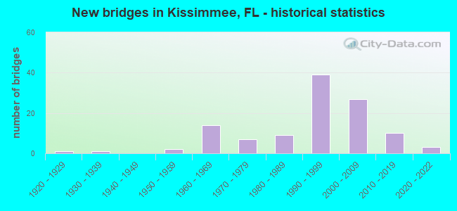
- New bridges - historical statistics
- 11920-1929
- 11930-1939
- 21950-1959
- 141960-1969
- 71970-1979
- 91980-1989
- 391990-1999
- 272000-2009
- 102010-2019
- 32020-2022

- Reconstructed bridges - Historical Statistics
- 11950-1959
- 11960-1969
- 01970-1979
- 21980-1989
- 51990-1999
- 42000-2009


- Bridge Condition - Deck
- 15.2%Very good
- 65.2%Good
- 19.6%Satisfactory

- Bridge Condition - Superstructure
- 13.0%Very good
- 71.7%Good
- 15.2%Satisfactory

- Bridge Condition - Substructure
- 17.4%Very good
- 69.6%Good
- 10.9%Satisfactory
- 2.2%Fair

- Bridge Condition - Channel
- 21.3%Very good
- 55.3%Good
- 19.1%Satisfactory
- 4.3%Fair

- Bridge Condition - Culverts
- 65.5%Good
- 31.0%Satisfactory
- 3.4%Fair
Find on map >> Show street view
Structure Number: 750556, Location: WB C-D over Ramp D (Lat: 28.352708, Lng: -81.527947), Route carried "on" structure: Ramp County highway 400, Year Built: 2001, Status: Open, Structure Length: 6.76m (22.18ft), Average Daily Traffic: 4,600 (year 2020), Truck Traffic: 6%, Average Future Daily Traffic: 7,981 (year 2042), Design Load: HS 20, Features Intersected: Ramp D1, Facility Carried by Structure: Ramp C-D WB
Minimum Vertical Clearance: 30+ m (98+ ft), Kilometerpoint: 0.425, Lanes on structure: 2, Lanes under structure: 1, Owner: State Highway Agency, Approaching Roadway Width: 12.2m (40.0ft), Material/Design: Prestressed concrete, Design/Construction: Stringer/Multi-beam, Number Of Spans In Main Unit: 2, Length of Maximum Span: 33.5m (109.9ft), Curb-To-Curb Width: 12.2m (40.0ft), Out-to-Out Width: 13.1m (43.0ft)
Condition: Deck: Good, Superstructure: Good, Substructure: Good, Operating Rating: 56.0 metric tons, Method Used To Determine Operating Rating: Load Factor (LF), Inventory Rating: 33.6 metric tons, Method Used To Determine Inventory Rating: Load Factor (LF), Structural Evaluation: Better than present minimum criteria, Deck Geometry: Superior to present desirable criteria, Underclear: Meets minimum limits, Approach Roadway Alignment: Equal to present desirable criteria, Designated Inspection Frequency: Every 24 months, Inspection Date: April 2021, Deck Structure Type: Concrete Cast-file-Place, Wearing Surface/Protective System: Wearing Surface: Monolithic Concrete
Find on map >> Show street view
Structure Number: 750642, Location: 0.4MI N OF OSCEOLA CO (Lat: 28.353736, Lng: -81.385367), Route carried "on" structure: State highway 91, Year Built: 2019, Status: Open, Structure Length: 3.12m (10.24ft), Average Daily Traffic: 59,200 (year 2014), Truck Traffic: 13%, Average Future Daily Traffic: 70,000 (year 2020), Design Load: HL 93, Features Intersected: CENTRAL FL RAIL CORRIDOR
Minimum Vertical Clearance: 30+ m (98+ ft), Kilometerpoint: 0.665, Lanes on structure: 7, Base Highway Network: Yes, Toll: On toll road, Owner: State Toll Authority, Approaching Roadway Width: 23.2m (76.1ft), Skew: 35 degrees, Material/Design: Prestressed concrete, Design/Construction: Stringer/Multi-beam, Number Of Spans In Main Unit: 1, Length of Maximum Span: 31.1m (102.0ft), Curb-To-Curb Width: 46.9m (153.9ft), Out-to-Out Width: 47.9m (157.2ft)
Condition: Deck: Very good, Superstructure: Good, Substructure: Very good, Operating Rating: 47.4 metric tons, Method Used To Determine Operating Rating: Load and Resistance Factor (LRFR), Inventory Rating: 36.6 metric tons, Method Used To Determine Inventory Rating: Load and Resistance Factor (LRFR), Structural Evaluation: Better than present minimum criteria, Deck Geometry: Superior to present desirable criteria, Underclear: Superior to present desirable criteria, Approach Roadway Alignment: Equal to present desirable criteria, Designated Inspection Frequency: Every 24 months, Inspection Date: September 2021, Deck Structure Type: Concrete Cast-file-Place, Wearing Surface/Protective System: Wearing Surface: Monolithic Concrete
Find on map >> Show street view
Structure Number: 75417, Location: 0.65 Miles East of US-17 (Lat: 28.421314, Lng: -81.393833), Route carried "on" structure: State highway , Year Built: 2018, Status: Open, Structure Length: 10.41m (34.15ft), Average Daily Traffic: 22,200 (year 2020), Truck Traffic: 26%, Average Future Daily Traffic: 37,740 (year 2042), Design Load: HL 93, Features Intersected: SR 91, Facility Carried by Structure: Taft-Vineland Road
Minimum Vertical Clearance: 30.18m (99.02ft), Kilometerpoint: 1.015, Lanes on structure: 2, Lanes under structure: 8, Owner: County Highway Agency, Approaching Roadway Width: 10.5m (34.4ft), Skew: 2 degrees, Material/Design: Prestressed concrete, Design/Construction: Stringer/Multi-beam, Number Of Spans In Main Unit: 3, Length of Maximum Span: 37.8m (124.0ft), Curb or Sidewalk Widths: Left: 0.0m, Right: 1.6m (5.2ft), Curb-To-Curb Width: 10.5m (34.4ft), Out-to-Out Width: 13.3m (43.6ft)
Condition: Deck: Very good, Superstructure: Good, Substructure: Very good, Operating Rating: 59.1 metric tons, Method Used To Determine Operating Rating: Load and Resistance Factor (LRFR), Inventory Rating: 34.3 metric tons, Method Used To Determine Inventory Rating: Load and Resistance Factor (LRFR), Structural Evaluation: Better than present minimum criteria, Deck Geometry: Somewhat better than minimum adequacy, Underclear: Equal to present desirable criteria, Approach Roadway Alignment: Equal to present desirable criteria, Designated Inspection Frequency: Every 19 months, Inspection Date: September 2020, Deck Structure Type: Concrete Cast-file-Place
Find on map >> Show street view
Structure Number: 920007, Location: 0.3 Mi N of US-192 (Lat: 28.309503, Lng: -81.403675), Route carried "on" structure: US 600, Year Built: 1937, Year Reconstructed: 1957, Status: Open, Structure Length: 1.22m (4.00ft), Average Daily Traffic: 28,000 (year 2020), Truck Traffic: 5%, Average Future Daily Traffic: 48,580 (year 2042), Design Load: H 15, Features Intersected: Canal, Facility Carried by Structure: US-92
Minimum Vertical Clearance: 30+ m (98+ ft), Kilometerpoint: 19.481, Lanes on structure: 5, Owner: State Highway Agency, Approaching Roadway Width: 19.5m (64.0ft), Skew: 1 degrees, Material/Design: Concrete, Design/Construction: Culvert, Number Of Spans In Main Unit: 3, Length of Maximum Span: 4.0m (13.1ft), Curb or Sidewalk Widths: Left: 2.1m (6.9ft), Right: 2.1m (6.9ft)
Condition: Channel: Satisfactory, Culverts: Fair, Operating Rating: 37.2 metric tons, Method Used To Determine Operating Rating: Load Factor (LF), Inventory Rating: 22.8 metric tons, Method Used To Determine Inventory Rating: Load Factor (LF), Structural Evaluation: Somewhat better than minimum adequacy, Waterway Adequacy: Equal to present desirable criteria, Approach Roadway Alignment: Equal to present desirable criteria, Designated Inspection Frequency: Every 24 months, Inspection Date: December 2021
Find on map >> Show street view
Structure Number: 920009, Location: US-441 WB - Mill Slough (Lat: 28.304300, Lng: -81.385633), Route carried "on" structure: US 441, Year Built: 1965, Year Reconstructed: 2003, Status: Open, Structure Length: 4.63m (15.19ft), Average Daily Traffic: 23,500 (year 2020), Truck Traffic: 8%, Average Future Daily Traffic: 40,772 (year 2042), Design Load: HS 20, Features Intersected: Mill Slough
Minimum Vertical Clearance: 30+ m (98+ ft), Kilometerpoint: 1.743, Lanes on structure: 3, Owner: State Highway Agency, Approaching Roadway Width: 13.6m (44.6ft), Material/Design: Concrete, Design/Construction: Slab, Number Of Spans In Main Unit: 5, Length of Maximum Span: 9.1m (29.9ft), Curb or Sidewalk Widths: Left: 3.0m (9.8ft), Right: 0.0m, Curb-To-Curb Width: 14.9m (48.9ft), Out-to-Out Width: 19.2m (63.0ft)
Condition: Deck: Satisfactory, Superstructure: Satisfactory, Substructure: Satisfactory, Channel: Good, Operating Rating: 43.5 metric tons, Method Used To Determine Operating Rating: Load and Resistance Factor (LRFR), Inventory Rating: 33.6 metric tons, Method Used To Determine Inventory Rating: Load and Resistance Factor (LRFR), Structural Evaluation: Equal to present minimum criteria, Deck Geometry: Equal to present minimum criteria, Waterway Adequacy: Equal to present desirable criteria, Approach Roadway Alignment: Equal to present desirable criteria, Designated Inspection Frequency: Every 24 months, Inspection Date: Febuary 2021, Deck Structure Type: Concrete Cast-file-Place, Wearing Surface/Protective System: Wearing Surface: Monolithic Concrete
Find on map >> Show street view
Structure Number: 920027, Location: 1.2 MI N OF KISS INTRCHNG (Lat: 28.304197, Lng: -81.361950), Route carried "on" structure: County highway 530, Year Built: 1963, Year Reconstructed: 2007, Status: Open, Structure Length: 7.25m (23.79ft), Average Daily Traffic: 17,750 (year 2020), Truck Traffic: 6%, Average Future Daily Traffic: 30,796 (year 2042), Design Load: HL 93, Features Intersected: SR 91 TPK
Minimum Vertical Clearance: 30+ m (98+ ft), Kilometerpoint: 1.959, Lanes on structure: 2, Lanes under structure: 4, Owner: State Toll Authority, Approaching Roadway Width: 8.2m (26.9ft), Skew: 3 degrees, Material/Design: Prestressed concrete, Design/Construction: Stringer/Multi-beam, Number Of Spans In Main Unit: 4, Length of Maximum Span: 21.7m (71.2ft), Curb or Sidewalk Widths: Left: 1.2m (3.9ft), Right: 0.0m, Curb-To-Curb Width: 8.2m (26.9ft), Out-to-Out Width: 10.6m (34.8ft)
Condition: Deck: Good, Superstructure: Satisfactory, Substructure: Good, Operating Rating: 47.6 metric tons, Method Used To Determine Operating Rating: Load and Resistance Factor (LRFR), Inventory Rating: 36.7 metric tons, Method Used To Determine Inventory Rating: Load and Resistance Factor (LRFR), Structural Evaluation: Equal to present minimum criteria, Deck Geometry: High priority of corrective action, Underclear: High priority of corrective action, Approach Roadway Alignment: Equal to present minimum criteria, Designated Inspection Frequency: Every 24 months, Inspection Date: September 2021, Deck Structure Type: Concrete Cast-file-Place
Find on map >> Show street view
Structure Number: 920031, Location: .5 Miles E. of US-17-92 (Lat: 28.304517, Lng: -81.395444), Route carried "on" structure: US 500, Year Built: 1966, Year Reconstructed: 1988, Status: Open, Structure Length: 1.04m (3.41ft), Average Daily Traffic: 38,500 (year 2020), Truck Traffic: 8%, Average Future Daily Traffic: 66,798 (year 2042), Design Load: HS 20+Mod, Features Intersected: Canal, Facility Carried by Structure: US-192
Minimum Vertical Clearance: 30+ m (98+ ft), Kilometerpoint: 0.803, Lanes on structure: 7, Owner: State Highway Agency, Approaching Roadway Width: 27.8m (91.2ft), Skew: 20 degrees, Material/Design: Concrete, Design/Construction: Culvert, Number Of Spans In Main Unit: 4, Length of Maximum Span: 2.4m (7.9ft)
Condition: Channel: Good, Culverts: Satisfactory, Operating Rating: 81.1 metric tons, Method Used To Determine Operating Rating: Load Factor (LF), Inventory Rating: 48.6 metric tons, Method Used To Determine Inventory Rating: Load Factor (LF), Structural Evaluation: Equal to present minimum criteria, Waterway Adequacy: Equal to present desirable criteria, Approach Roadway Alignment: Equal to present desirable criteria, Designated Inspection Frequency: Every 24 months, Underwater Inspection Frequency: Every 24 months, Inspection Date: November 2021, Underwater Inspection Date: November 2021
Find on map >> Show street view
Structure Number: 920075, Location: 0.96MI N of Partin Sttlmn (Lat: 28.289281, Lng: -81.346931), Route carried "on" structure: Ramp State highway 91, Year Built: 1963, Status: Open, Structure Length: 5.96m (19.55ft), Average Daily Traffic: 9,650 (year 2020), Truck Traffic: 12%, Average Future Daily Traffic: 16,743 (year 2042), Design Load: H 20, Features Intersected: SR 91 TPK
Minimum Vertical Clearance: 30+ m (98+ ft), Kilometerpoint: 0.687, Lanes on structure: 1, Lanes under structure: 5, Toll: On toll road, Owner: State Toll Authority, Approaching Roadway Width: 12.8m (42.0ft), Material/Design: Prestressed concrete, Design/Construction: Stringer/Multi-beam, Number Of Spans In Main Unit: 4, Length of Maximum Span: 20.6m (67.6ft), Curb or Sidewalk Widths: Left: 0.6m (2.0ft), Right: 0.6m (2.0ft), Curb-To-Curb Width: 11.7m (38.4ft), Out-to-Out Width: 13.6m (44.6ft)
Condition: Deck: Good, Superstructure: Satisfactory, Substructure: Good, Operating Rating: 50.6 metric tons, Method Used To Determine Operating Rating: Load and Resistance Factor (LRFR), Inventory Rating: 39.0 metric tons, Method Used To Determine Inventory Rating: Load and Resistance Factor (LRFR), Structural Evaluation: Equal to present minimum criteria, Deck Geometry: Superior to present desirable criteria, Underclear: Meets minimum limits, Approach Roadway Alignment: Equal to present minimum criteria, Designated Inspection Frequency: Every 24 months, Inspection Date: August 2021, Deck Structure Type: Concrete Cast-file-Place, Wearing Surface/Protective System: Wearing Surface: Bituminous
Find on map >> Show street view
Structure Number: 920077, Location: 1.1MI N OF KISS. INTERCH (Lat: 28.301222, Lng: -81.359436), Route carried "on" structure: State highway 91, Year Built: 1963, Status: Open, Structure Length: 1.89m (6.20ft), Average Daily Traffic: 30,600 (year 2020), Truck Traffic: 12%, Average Future Daily Traffic: 53,091 (year 2042), Design Load: H 20, Features Intersected: BASS SLOUGH
Minimum Vertical Clearance: 30+ m (98+ ft), Kilometerpoint: 59.845, Lanes on structure: 2, Base Highway Network: Yes, Toll: On toll road, Owner: State Toll Authority, Approaching Roadway Width: 11.6m (38.1ft), Material/Design: Prestressed concrete, Design/Construction: Slab, Number Of Spans In Main Unit: 2, Length of Maximum Span: 9.4m (30.8ft), Curb or Sidewalk Widths: Left: 0.6m (2.0ft), Right: 0.6m (2.0ft), Curb-To-Curb Width: 11.6m (38.1ft), Out-to-Out Width: 13.4m (44.0ft)
Condition: Deck: Good, Superstructure: Good, Substructure: Good, Channel: Satisfactory, Operating Rating: 50.3 metric tons, Method Used To Determine Operating Rating: Load and Resistance Factor (LRFR), Inventory Rating: 46.2 metric tons, Method Used To Determine Inventory Rating: Load and Resistance Factor (LRFR), Structural Evaluation: Better than present minimum criteria, Deck Geometry: Equal to present minimum criteria, Waterway Adequacy: Equal to present desirable criteria, Approach Roadway Alignment: Equal to present desirable criteria, Designated Inspection Frequency: Every 24 months, Inspection Date: September 2021, Deck Structure Type: Concrete Precast Panels, Wearing Surface/Protective System: Wearing Surface: Bituminous
Find on map >> Show street view
Structure Number: 920079, Location: .15 MI S OF OSCEOLA PKWY (Lat: 28.338306, Lng: -81.379275), Route carried "on" structure: State highway 91, Year Built: 1963, Year Reconstructed: 1995, Status: Open, Structure Length: 0.97m (3.18ft), Average Daily Traffic: 61,200 (year 2020), Truck Traffic: 12%, Average Future Daily Traffic: 106,182 (year 2042), Design Load: HS 20, Features Intersected: MILL SLOUGH
Minimum Vertical Clearance: 30+ m (98+ ft), Kilometerpoint: 64.432, Lanes on structure: 6, Base Highway Network: Yes, Toll: On toll road, Owner: State Toll Authority, Approaching Roadway Width: 26.5m (86.9ft), Skew: 10 degrees, Material/Design: Concrete, Design/Construction: Culvert, Number Of Spans In Main Unit: 3, Length of Maximum Span: 3.0m (9.8ft)
Condition: Channel: Good, Culverts: Satisfactory, Operating Rating: 70.9 metric tons, Method Used To Determine Operating Rating: Load Factor (LF), Inventory Rating: 42.6 metric tons, Method Used To Determine Inventory Rating: Load Factor (LF), Structural Evaluation: Equal to present minimum criteria, Waterway Adequacy: Equal to present desirable criteria, Approach Roadway Alignment: Equal to present desirable criteria, Designated Inspection Frequency: Every 24 months, Underwater Inspection Frequency: Every 24 months, Inspection Date: September 2021, Underwater Inspection Date: September 2021
Find on map >> Show street view
Structure Number: 920081, Location: World Drive SB - US-192 (Lat: 28.332542, Lng: -81.569497), Route carried "on" structure: Ramp Other road 530, Year Built: 1970, Status: Open, Structure Length: 7.71m (25.30ft), Average Daily Traffic: 5,300 (year 2020), Truck Traffic: 6%, Average Future Daily Traffic: 9,196 (year 2042), Design Load: HS 20, Features Intersected: US-192, Facility Carried by Structure: World Drive SB
Minimum Vertical Clearance: 30+ m (98+ ft), Kilometerpoint: 0.435, Lanes on structure: 2, Lanes under structure: 6, Owner: State Highway Agency, Approaching Roadway Width: 10.7m (35.1ft), Skew: 1 degrees, Material/Design: Prestressed concrete, Design/Construction: Stringer/Multi-beam, Number Of Spans In Main Unit: 4, Length of Maximum Span: 24.4m (80.1ft), Curb-To-Curb Width: 12.2m (40.0ft), Out-to-Out Width: 12.8m (42.0ft)
Condition: Deck: Satisfactory, Superstructure: Good, Substructure: Satisfactory, Operating Rating: 50.3 metric tons, Method Used To Determine Operating Rating: Load Factor (LF), Inventory Rating: 31.5 metric tons, Method Used To Determine Inventory Rating: Load Factor (LF), Structural Evaluation: Equal to present minimum criteria, Deck Geometry: Superior to present desirable criteria, Underclear: Better than present minimum criteria, Approach Roadway Alignment: Equal to present desirable criteria, Designated Inspection Frequency: Every 24 months, Inspection Date: March 2020, Deck Structure Type: Concrete Cast-file-Place, Wearing Surface/Protective System: Wearing Surface: Monolithic Concrete
Find on map >> Show street view
Structure Number: 920112, Location: US-441 EB - Mill Slough (Lat: 28.304097, Lng: -81.385672), Route carried "on" structure: US 441, Year Built: 1965, Year Reconstructed: 2003, Status: Open, Structure Length: 4.63m (15.19ft), Average Daily Traffic: 23,500 (year 2020), Truck Traffic: 8%, Average Future Daily Traffic: 40,772 (year 2042), Design Load: HS 20, Features Intersected: Mill Slough
Minimum Vertical Clearance: 30+ m (98+ ft), Kilometerpoint: 1.743, Lanes on structure: 3, Owner: State Highway Agency, Approaching Roadway Width: 13.4m (44.0ft), Material/Design: Concrete, Design/Construction: Slab, Number Of Spans In Main Unit: 5, Length of Maximum Span: 9.1m (29.9ft), Curb or Sidewalk Widths: Left: 0.0m, Right: 3.0m (9.8ft), Curb-To-Curb Width: 15.1m (49.5ft), Out-to-Out Width: 19.2m (63.0ft)
Condition: Deck: Satisfactory, Superstructure: Satisfactory, Substructure: Satisfactory, Channel: Good, Operating Rating: 43.5 metric tons, Method Used To Determine Operating Rating: Load and Resistance Factor (LRFR), Inventory Rating: 33.6 metric tons, Method Used To Determine Inventory Rating: Load and Resistance Factor (LRFR), Structural Evaluation: Equal to present minimum criteria, Deck Geometry: Equal to present minimum criteria, Waterway Adequacy: Equal to present desirable criteria, Approach Roadway Alignment: Equal to present desirable criteria, Designated Inspection Frequency: Every 24 months, Inspection Date: Febuary 2021, Deck Structure Type: Concrete Cast-file-Place, Wearing Surface/Protective System: Wearing Surface: Monolithic Concrete
Find on map >> Show street view
Structure Number: 920135, Location: 1.3 MI N OF CR 523 (Lat: 28.292389, Lng: -81.351528), Route carried "on" structure: County highway 530, Year Built: 1963, Status: Open, Structure Length: 5.85m (19.19ft), Average Daily Traffic: 15,200 (year 2020), Truck Traffic: 3%, Average Future Daily Traffic: 26,372 (year 2042), Design Load: H 20, Features Intersected: SR 91 TPK
Minimum Vertical Clearance: 30+ m (98+ ft), Kilometerpoint: 0.686, Lanes on structure: 2, Lanes under structure: 4, Owner: State Toll Authority, Approaching Roadway Width: 8.5m (27.9ft), Skew: 1 degrees, Material/Design: Prestressed concrete, Design/Construction: Stringer/Multi-beam, Number Of Spans In Main Unit: 4, Length of Maximum Span: 17.3m (56.8ft), Curb or Sidewalk Widths: Left: 0.6m (2.0ft), Right: 0.6m (2.0ft), Curb-To-Curb Width: 8.5m (27.9ft), Out-to-Out Width: 10.3m (33.8ft)
Condition: Deck: Good, Superstructure: Good, Substructure: Good, Operating Rating: 35.7 metric tons, Method Used To Determine Operating Rating: Load and Resistance Factor (LRFR), Inventory Rating: 27.5 metric tons, Method Used To Determine Inventory Rating: Load and Resistance Factor (LRFR), Structural Evaluation: Equal to present minimum criteria, Deck Geometry: High priority of replacement, Underclear: High priority of corrective action, Approach Roadway Alignment: Equal to present desirable criteria, Designated Inspection Frequency: Every 24 months, Inspection Date: September 2021, Deck Structure Type: Concrete Cast-file-Place
Find on map >> Show street view
Structure Number: 920136, Location: 1.1MI N OF KISS. INTERCH (Lat: 28.301331, Lng: -81.359281), Route carried "on" structure: State highway 91, Year Built: 1963, Status: Open, Structure Length: 1.89m (6.20ft), Average Daily Traffic: 30,600 (year 2020), Truck Traffic: 12%, Average Future Daily Traffic: 53,091 (year 2042), Design Load: H 20, Features Intersected: BASS SLOUGH
Minimum Vertical Clearance: 30+ m (98+ ft), Kilometerpoint: 59.845, Lanes on structure: 2, Base Highway Network: Yes, Toll: On toll road, Owner: State Toll Authority, Approaching Roadway Width: 11.6m (38.1ft), Material/Design: Prestressed concrete, Design/Construction: Slab, Number Of Spans In Main Unit: 2, Length of Maximum Span: 9.4m (30.8ft), Curb or Sidewalk Widths: Left: 0.6m (2.0ft), Right: 0.6m (2.0ft), Curb-To-Curb Width: 11.6m (38.1ft), Out-to-Out Width: 13.4m (44.0ft)
Condition: Deck: Satisfactory, Superstructure: Satisfactory, Substructure: Good, Channel: Fair, Operating Rating: 50.3 metric tons, Method Used To Determine Operating Rating: Load and Resistance Factor (LRFR), Inventory Rating: 46.2 metric tons, Method Used To Determine Inventory Rating: Load and Resistance Factor (LRFR), Structural Evaluation: Equal to present minimum criteria, Deck Geometry: Equal to present minimum criteria, Waterway Adequacy: Equal to present desirable criteria, Approach Roadway Alignment: Equal to present desirable criteria, Designated Inspection Frequency: Every 24 months, Underwater Inspection Frequency: Every 24 months, Inspection Date: September 2021, Underwater Inspection Date: September 2021, Deck Structure Type: Concrete Precast Panels, Wearing Surface/Protective System: Wearing Surface: Bituminous
Find on map >> Show street view
Structure Number: 920137, Location: 3.9 Mi E of Kissimmee (Lat: 28.282053, Lng: -81.348056), Route carried "on" structure: US 500, Year Built: 1928, Year Reconstructed: 1965, Status: Open, Structure Length: 0.64m (2.10ft), Average Daily Traffic: 48,000 (year 2020), Truck Traffic: 6%, Average Future Daily Traffic: 83,280 (year 2042), Design Load: HS 20+Mod, Features Intersected: Outfall, Facility Carried by Structure: US-441
Minimum Vertical Clearance: 30+ m (98+ ft), Kilometerpoint: 6.273, Lanes on structure: 7, Owner: State Highway Agency, Approaching Roadway Width: 30.1m (98.8ft), Skew: 20 degrees, Material/Design: Concrete, Design/Construction: Culvert, Number Of Spans In Main Unit: 2, Length of Maximum Span: 3.0m (9.8ft)
Condition: Channel: Good, Culverts: Good, Operating Rating: 43.0 metric tons, Method Used To Determine Operating Rating: Load and Resistance Factor (LRFR), Inventory Rating: 33.2 metric tons, Method Used To Determine Inventory Rating: Load and Resistance Factor (LRFR), Structural Evaluation: Better than present minimum criteria, Waterway Adequacy: Equal to present desirable criteria, Approach Roadway Alignment: Equal to present desirable criteria, Designated Inspection Frequency: Every 24 months, Inspection Date: May 2020
Find on map >> Show street view
Structure Number: 920138, Location: 0.5 MI W of FL Turnpike (Lat: 28.272431, Lng: -81.338197), Route carried "on" structure: US 500, Year Built: 1965, Year Reconstructed: 2004, Status: Open, Structure Length: 0.64m (2.10ft), Average Daily Traffic: 48,000 (year 2020), Truck Traffic: 6%, Average Future Daily Traffic: 83,280 (year 2042), Design Load: H 20, Features Intersected: Outfall, Facility Carried by Structure: US-441
Minimum Vertical Clearance: 30+ m (98+ ft), Kilometerpoint: 7.722, Lanes on structure: 7, Base Highway Network: Yes, Owner: State Highway Agency, Approaching Roadway Width: 26.3m (86.3ft), Skew: 10 degrees, Material/Design: Concrete, Design/Construction: Culvert, Number Of Spans In Main Unit: 2, Length of Maximum Span: 3.0m (9.8ft), Curb or Sidewalk Widths: Left: 0.0m, Right: 1.8m (5.9ft)
Condition: Channel: Satisfactory, Culverts: Satisfactory, Operating Rating: 78.9 metric tons, Method Used To Determine Operating Rating: Load Factor (LF), Inventory Rating: 47.4 metric tons, Method Used To Determine Inventory Rating: Load Factor (LF), Structural Evaluation: Equal to present minimum criteria, Waterway Adequacy: Equal to present desirable criteria, Approach Roadway Alignment: Equal to present desirable criteria, Designated Inspection Frequency: Every 24 months, Inspection Date: April 2020, Deck Structure Type: Concrete Cast-file-Place
Find on map >> Show street view
Structure Number: 920143, Location: US-17-92-Clay St & RR (Lat: 28.285553, Lng: -81.416247), Route carried "on" structure: US 1792, Year Built: 1985, Status: Open, Structure Length: 9.16m (30.05ft), Average Daily Traffic: 20,750 (year 2020), Truck Traffic: 11%, Average Future Daily Traffic: 36,001 (year 2042), Design Load: HS 20, Features Intersected: Clay St. & CFRC RR, Facility Carried by Structure: US-17-92 SB
Minimum Vertical Clearance: 30+ m (98+ ft), Kilometerpoint: 15.842, Lanes on structure: 2, Lanes under structure: 2, Owner: State Highway Agency, Approaching Roadway Width: 7.6m (24.9ft), Skew: 3 degrees, Material/Design: Prestressed concrete, Design/Construction: Stringer/Multi-beam, Number Of Spans In Main Unit: 5, Length of Maximum Span: 19.2m (63.0ft), Curb or Sidewalk Widths: Left: 1.5m (4.9ft), Right: 0.0m, Curb-To-Curb Width: 10.2m (33.5ft), Out-to-Out Width: 12.7m (41.7ft)
Condition: Deck: Satisfactory, Superstructure: Good, Substructure: Good, Operating Rating: 69.1 metric tons, Method Used To Determine Operating Rating: Load Factor (LF), Inventory Rating: 41.5 metric tons, Method Used To Determine Inventory Rating: Load Factor (LF), Structural Evaluation: Better than present minimum criteria, Deck Geometry: Somewhat better than minimum adequacy, Underclear: Superior to present desirable criteria, Approach Roadway Alignment: Equal to present desirable criteria, Designated Inspection Frequency: Every 24 months, Inspection Date: October 2021, Deck Structure Type: Concrete Cast-file-Place, Wearing Surface/Protective System: Wearing Surface: Monolithic Concrete
Find on map >> Show street view
Structure Number: 920144, Location: US-17-92 NB- Clay & CFRC (Lat: 28.285531, Lng: -81.415981), Route carried "on" structure: US 1792, Year Built: 1985, Status: Open, Structure Length: 9.17m (30.09ft), Average Daily Traffic: 20,750 (year 2020), Truck Traffic: 11%, Average Future Daily Traffic: 36,001 (year 2042), Design Load: HS 20, Features Intersected: Clay St. & CFRC, Facility Carried by Structure: US-17-92 NB
Minimum Vertical Clearance: 30+ m (98+ ft), Kilometerpoint: 15.842, Lanes on structure: 2, Lanes under structure: 2, Owner: State Highway Agency, Approaching Roadway Width: 9.1m (29.9ft), Skew: 3 degrees, Material/Design: Prestressed concrete, Design/Construction: Stringer/Multi-beam, Number Of Spans In Main Unit: 5, Length of Maximum Span: 19.2m (63.0ft), Curb or Sidewalk Widths: Left: 0.0m, Right: 1.5m (4.9ft), Curb-To-Curb Width: 10.1m (33.1ft), Out-to-Out Width: 12.7m (41.7ft)
Condition: Deck: Satisfactory, Superstructure: Good, Substructure: Good, Operating Rating: 69.1 metric tons, Method Used To Determine Operating Rating: Load Factor (LF), Inventory Rating: 41.5 metric tons, Method Used To Determine Inventory Rating: Load Factor (LF), Structural Evaluation: Better than present minimum criteria, Deck Geometry: Somewhat better than minimum adequacy, Underclear: Superior to present desirable criteria, Approach Roadway Alignment: Equal to present desirable criteria, Designated Inspection Frequency: Every 24 months, Inspection Date: October 2021, Deck Structure Type: Concrete Cast-file-Place, Wearing Surface/Protective System: Wearing Surface: Monolithic Concrete
Find on map >> Show street view
Structure Number: 920147, Location: 0.52 Mi. S of SR-531 (Lat: 28.278150, Lng: -81.417331), Route carried "on" structure: US 600, Year Built: 1993, Status: Open, Structure Length: 1.34m (4.40ft), Average Daily Traffic: 41,500 (year 2020), Truck Traffic: 11%, Average Future Daily Traffic: 72,002 (year 2042), Design Load: HS 20, Features Intersected: Drainage Canal, Facility Carried by Structure: US-92
Minimum Vertical Clearance: 30+ m (98+ ft), Kilometerpoint: 15.044, Lanes on structure: 6, Base Highway Network: Yes, Owner: State Highway Agency, Approaching Roadway Width: 18.4m (60.4ft), Skew: 20 degrees, Material/Design: Concrete, Design/Construction: Culvert, Number Of Spans In Main Unit: 4, Length of Maximum Span: 3.0m (9.8ft)
Condition: Channel: Good, Culverts: Satisfactory, Inventory Rating: 72.9 metric tons, Method Used To Determine Inventory Rating: Load Factor (LF), Structural Evaluation: Equal to present minimum criteria, Waterway Adequacy: Equal to present minimum criteria, Approach Roadway Alignment: Equal to present desirable criteria, Designated Inspection Frequency: Every 24 months, Underwater Inspection Frequency: Every 24 months, Inspection Date: August 2021, Underwater Inspection Date: August 2021
Find on map >> Show street view
Structure Number: 920151, Location: US-17-92 SB - Shingle Cr (Lat: 28.268864, Lng: -81.426722), Route carried "on" structure: US 1792, Year Built: 1994, Status: Open, Structure Length: 10.42m (34.19ft), Average Daily Traffic: 20,750 (year 2020), Truck Traffic: 11%, Average Future Daily Traffic: 36,001 (year 2042), Design Load: HS 20, Features Intersected: Shingle Creek, Facility Carried by Structure: US-17-92 SB
Minimum Vertical Clearance: 30+ m (98+ ft), Kilometerpoint: 13.593, Lanes on structure: 2, Base Highway Network: Yes, Owner: State Highway Agency, Approaching Roadway Width: 8.5m (27.9ft), Material/Design: Prestressed concrete, Design/Construction: Stringer/Multi-beam, Number Of Spans In Main Unit: 7, Length of Maximum Span: 14.8m (48.6ft), Curb-To-Curb Width: 12.2m (40.0ft), Out-to-Out Width: 13.0m (42.7ft)
Condition: Deck: Good, Superstructure: Good, Substructure: Good, Channel: Satisfactory, Operating Rating: 74.4 metric tons, Method Used To Determine Operating Rating: Load Factor (LF), Inventory Rating: 44.6 metric tons, Method Used To Determine Inventory Rating: Load Factor (LF), Structural Evaluation: Better than present minimum criteria, Deck Geometry: Better than present minimum criteria, Waterway Adequacy: Better than present minimum criteria, Approach Roadway Alignment: Equal to present desirable criteria, Designated Inspection Frequency: Every 24 months, Underwater Inspection Frequency: Every 24 months, Inspection Date: September 2021, Underwater Inspection Date: September 2021, Deck Structure Type: Concrete Cast-file-Place, Wearing Surface/Protective System: Wearing Surface: Monolithic Concrete
Find on map >> Show street view
Structure Number: 920152, Location: US-17-92 NB - Shingle Cr (Lat: 28.268764, Lng: -81.426528), Route carried "on" structure: US 1792, Year Built: 1992, Status: Open, Structure Length: 10.42m (34.19ft), Average Daily Traffic: 20,750 (year 2020), Truck Traffic: 11%, Average Future Daily Traffic: 36,001 (year 2042), Design Load: HS 20, Features Intersected: Shingle Creek, Facility Carried by Structure: US-17-92 NB
Minimum Vertical Clearance: 30+ m (98+ ft), Kilometerpoint: 13.593, Lanes on structure: 2, Base Highway Network: Yes, Owner: State Highway Agency, Approaching Roadway Width: 8.5m (27.9ft), Material/Design: Prestressed concrete, Design/Construction: Stringer/Multi-beam, Number Of Spans In Main Unit: 7, Length of Maximum Span: 14.9m (48.9ft), Curb-To-Curb Width: 12.2m (40.0ft), Out-to-Out Width: 13.0m (42.7ft)
Condition: Deck: Good, Superstructure: Good, Substructure: Satisfactory, Channel: Satisfactory, Operating Rating: 74.4 metric tons, Method Used To Determine Operating Rating: Load Factor (LF), Inventory Rating: 44.6 metric tons, Method Used To Determine Inventory Rating: Load Factor (LF), Structural Evaluation: Equal to present minimum criteria, Deck Geometry: Better than present minimum criteria, Waterway Adequacy: Better than present minimum criteria, Approach Roadway Alignment: Equal to present desirable criteria, Designated Inspection Frequency: Every 24 months, Underwater Inspection Frequency: Every 24 months, Inspection Date: September 2021, Underwater Inspection Date: September 2021, Deck Structure Type: Concrete Cast-file-Place, Wearing Surface/Protective System: Wearing Surface: Monolithic Concrete
Find on map >> Show street view
Structure Number: 920153, Location: 0.25 MI E OF I-4 SR 400 (Lat: 28.326586, Lng: -81.547161), Route carried "on" structure: State highway 417, Year Built: 1996, Status: Open, Structure Length: 3.51m (11.52ft), Average Daily Traffic: 13,050 (year 2020), Truck Traffic: 12%, Average Future Daily Traffic: 22,642 (year 2042), Design Load: HS 20+Mod, Features Intersected: CELEBRATION PL
Minimum Vertical Clearance: 30+ m (98+ ft), Kilometerpoint: 0.000, Lanes on structure: 2, Lanes under structure: 4, Base Highway Network: Yes, Toll: On toll road, Owner: State Toll Authority, Approaching Roadway Width: 12.2m (40.0ft), Material/Design: Prestressed concrete, Design/Construction: Stringer/Multi-beam, Number Of Spans In Main Unit: 1, Length of Maximum Span: 35.1m (115.2ft), Curb-To-Curb Width: 13.4m (44.0ft), Out-to-Out Width: 14.4m (47.2ft)
Condition: Deck: Good, Superstructure: Good, Substructure: Good, Operating Rating: 48.5 metric tons, Method Used To Determine Operating Rating: Load and Resistance Factor (LRFR), Inventory Rating: 40.6 metric tons, Method Used To Determine Inventory Rating: Load and Resistance Factor (LRFR), Structural Evaluation: Better than present minimum criteria, Deck Geometry: Superior to present desirable criteria, Underclear: Equal to present minimum criteria, Approach Roadway Alignment: Equal to present desirable criteria, Designated Inspection Frequency: Every 24 months, Inspection Date: January 2022, Deck Structure Type: Concrete Cast-file-Place
Find on map >> Show street view
Structure Number: 920154, Location: 0.25 MI E OF I-4 SR 400 (Lat: 28.326397, Lng: -81.547175), Route carried "on" structure: State highway 417, Year Built: 1996, Status: Open, Structure Length: 3.51m (11.52ft), Average Daily Traffic: 13,050 (year 2020), Truck Traffic: 12%, Average Future Daily Traffic: 22,642 (year 2042), Design Load: HS 20+Mod, Features Intersected: CELEBRATION PL
Minimum Vertical Clearance: 30+ m (98+ ft), Kilometerpoint: 0.000, Lanes on structure: 2, Lanes under structure: 4, Base Highway Network: Yes, Toll: On toll road, Owner: State Toll Authority, Approaching Roadway Width: 12.2m (40.0ft), Material/Design: Prestressed concrete, Design/Construction: Stringer/Multi-beam, Number Of Spans In Main Unit: 1, Length of Maximum Span: 35.1m (115.2ft), Curb-To-Curb Width: 13.4m (44.0ft), Out-to-Out Width: 14.4m (47.2ft)
Condition: Deck: Good, Superstructure: Good, Substructure: Good, Operating Rating: 48.5 metric tons, Method Used To Determine Operating Rating: Load and Resistance Factor (LRFR), Inventory Rating: 40.6 metric tons, Method Used To Determine Inventory Rating: Load and Resistance Factor (LRFR), Structural Evaluation: Better than present minimum criteria, Deck Geometry: Superior to present desirable criteria, Underclear: Equal to present minimum criteria, Approach Roadway Alignment: Equal to present desirable criteria, Designated Inspection Frequency: Every 24 months, Inspection Date: January 2022, Deck Structure Type: Concrete Cast-file-Place
Find on map >> Show street view
Structure Number: 920164, Location: US-192- Shingle Creek (Lat: 28.304139, Lng: -81.451000), Route carried "on" structure: State highway 192, Year Built: 2005, Status: Open, Structure Length: 4.85m (15.91ft), Average Daily Traffic: 58,051 (year 2020), Truck Traffic: 3%, Average Future Daily Traffic: 100,718 (year 2042), Design Load: HS 20, Features Intersected: Shingle Creek
Minimum Vertical Clearance: 30+ m (98+ ft), Kilometerpoint: 20.091, Lanes on structure: 6, Base Highway Network: Yes, Owner: State Highway Agency, Approaching Roadway Width: 25.1m (82.3ft), Skew: 20 degrees, Material/Design: Concrete continuous, Design/Construction: Slab, Number Of Spans In Main Unit: 5, Length of Maximum Span: 11.3m (37.1ft), Curb or Sidewalk Widths: Left: 3.0m (9.8ft), Right: 3.0m (9.8ft), Curb-To-Curb Width: 33.0m (108.3ft), Out-to-Out Width: 41.1m (134.8ft)
Condition: Deck: Good, Superstructure: Good, Substructure: Good, Channel: Good, Operating Rating: 73.4 metric tons, Method Used To Determine Operating Rating: Load Factor (LF), Inventory Rating: 44.0 metric tons, Method Used To Determine Inventory Rating: Load Factor (LF), Structural Evaluation: Better than present minimum criteria, Deck Geometry: Superior to present desirable criteria, Waterway Adequacy: Better than present minimum criteria, Approach Roadway Alignment: Equal to present desirable criteria, Designated Inspection Frequency: Every 24 months, Underwater Inspection Frequency: Every 24 months, Inspection Date: October 2021, Underwater Inspection Date: October 2021, Deck Structure Type: Concrete Cast-file-Place, Wearing Surface/Protective System: Wearing Surface: Monolithic Concrete
Find on map >> Show street view
Structure Number: 920165, Location: World Drive SB - US-192 (Lat: 28.332561, Lng: -81.568153), Route carried "on" structure: State highway 530, Year Built: 1998, Status: Open, Structure Length: 7.13m (23.39ft), Average Daily Traffic: 12,500 (year 2020), Truck Traffic: 6%, Average Future Daily Traffic: 21,688 (year 2042), Design Load: HS 20, Features Intersected: US-192, Facility Carried by Structure: World Drive SB
Minimum Vertical Clearance: 30+ m (98+ ft), Kilometerpoint: 3.655, Lanes on structure: 4, Lanes under structure: 8, Owner: State Highway Agency, Approaching Roadway Width: 16.8m (55.1ft), Material/Design: Prestressed concrete, Design/Construction: Stringer/Multi-beam, Number Of Spans In Main Unit: 4, Length of Maximum Span: 23.0m (75.5ft), Curb-To-Curb Width: 16.8m (55.1ft), Out-to-Out Width: 17.9m (58.7ft)
Condition: Deck: Good, Superstructure: Good, Substructure: Good, Operating Rating: 64.5 metric tons, Method Used To Determine Operating Rating: Load Factor (LF), Inventory Rating: 38.6 metric tons, Method Used To Determine Inventory Rating: Load Factor (LF), Structural Evaluation: Better than present minimum criteria, Deck Geometry: Somewhat better than minimum adequacy, Underclear: Better than present minimum criteria, Approach Roadway Alignment: Equal to present desirable criteria, Designated Inspection Frequency: Every 24 months, Inspection Date: October 2021, Deck Structure Type: Concrete Cast-file-Place, Wearing Surface/Protective System: Wearing Surface: Monolithic Concrete
Find on map >> Show street view
Structure Number: 920166, Location: World Drive NB - US-192 (Lat: 28.332567, Lng: -81.567914), Route carried "on" structure: Other road , Year Built: 1998, Status: Open, Structure Length: 7.10m (23.29ft), Average Daily Traffic: 16,500 (year 2016), Truck Traffic: 6%, Average Future Daily Traffic: 28,628 (year 2038), Design Load: HS 20, Features Intersected: US-192, Facility Carried by Structure: World Drive NB
Minimum Vertical Clearance: 30+ m (98+ ft), Kilometerpoint: 0.002, Lanes on structure: 4, Lanes under structure: 8, Owner: State Highway Agency, Approaching Roadway Width: 12.8m (42.0ft), Material/Design: Prestressed concrete, Design/Construction: Stringer/Multi-beam, Number Of Spans In Main Unit: 4, Length of Maximum Span: 23.1m (75.8ft), Curb-To-Curb Width: 20.7m (67.9ft), Out-to-Out Width: 21.6m (70.9ft)
Condition: Deck: Good, Superstructure: Good, Substructure: Good, Operating Rating: 63.3 metric tons, Method Used To Determine Operating Rating: Load Factor (LF), Inventory Rating: 38.0 metric tons, Method Used To Determine Inventory Rating: Load Factor (LF), Structural Evaluation: Better than present minimum criteria, Deck Geometry: Superior to present desirable criteria, Underclear: Better than present minimum criteria, Approach Roadway Alignment: Equal to present desirable criteria, Designated Inspection Frequency: Every 24 months, Inspection Date: October 2021, Deck Structure Type: Concrete Cast-file-Place, Wearing Surface/Protective System: Wearing Surface: Monolithic Concrete
Find on map >> Show street view
Structure Number: 920167, Location: World Dr SB - Ramp D2 (Lat: 28.331064, Lng: -81.568167), Route carried "on" structure: Other road 530, Year Built: 1998, Status: Open, Structure Length: 2.89m (9.48ft), Average Daily Traffic: 12,500 (year 2020), Truck Traffic: 6%, Average Future Daily Traffic: 21,688 (year 2042), Design Load: HS 20+Mod, Features Intersected: World Dr. Ramp D2, Facility Carried by Structure: World Drive SB
Minimum Vertical Clearance: 30+ m (98+ ft), Kilometerpoint: 3.504, Lanes on structure: 3, Lanes under structure: 2, Owner: State Highway Agency, Approaching Roadway Width: 16.5m (54.1ft), Skew: 2 degrees, Material/Design: Prestressed concrete, Design/Construction: Stringer/Multi-beam, Number Of Spans In Main Unit: 1, Length of Maximum Span: 28.3m (92.8ft), Curb-To-Curb Width: 17.0m (55.8ft), Out-to-Out Width: 18.0m (59.1ft)
Condition: Deck: Good, Superstructure: Good, Substructure: Good, Operating Rating: 85.5 metric tons, Method Used To Determine Operating Rating: Load Factor (LF), Inventory Rating: 51.3 metric tons, Method Used To Determine Inventory Rating: Load Factor (LF), Structural Evaluation: Better than present minimum criteria, Deck Geometry: Superior to present desirable criteria, Underclear: Equal to present minimum criteria, Approach Roadway Alignment: Equal to present desirable criteria, Designated Inspection Frequency: Every 24 months, Inspection Date: September 2021, Deck Structure Type: Concrete Cast-file-Place, Wearing Surface/Protective System: Wearing Surface: Monolithic Concrete
Find on map >> Show street view
Structure Number: 920168, Location: World Dr. NB - Ramp D2 (Lat: 28.330958, Lng: -81.567953), Route carried "on" structure: Other road 530, Year Built: 1998, Status: Open, Structure Length: 2.90m (9.51ft), Average Daily Traffic: 12,500 (year 2020), Truck Traffic: 6%, Average Future Daily Traffic: 21,688 (year 2042), Design Load: HS 20+Mod, Features Intersected: World Dr. Ramp D2, Facility Carried by Structure: World Drive NB
Minimum Vertical Clearance: 30+ m (98+ ft), Kilometerpoint: 3.504, Lanes on structure: 2, Lanes under structure: 2, Owner: State Highway Agency, Approaching Roadway Width: 15.2m (49.9ft), Skew: 2 degrees, Material/Design: Prestressed concrete, Design/Construction: Stringer/Multi-beam, Number Of Spans In Main Unit: 1, Length of Maximum Span: 28.3m (92.8ft), Curb-To-Curb Width: 15.2m (49.9ft), Out-to-Out Width: 16.1m (52.8ft)
Condition: Deck: Good, Superstructure: Good, Substructure: Good, Operating Rating: 86.8 metric tons, Method Used To Determine Operating Rating: Load Factor (LF), Inventory Rating: 52.3 metric tons, Method Used To Determine Inventory Rating: Load Factor (LF), Structural Evaluation: Better than present minimum criteria, Deck Geometry: Superior to present desirable criteria, Underclear: Equal to present minimum criteria, Approach Roadway Alignment: Equal to present desirable criteria, Designated Inspection Frequency: Every 24 months, Inspection Date: September 2021, Deck Structure Type: Concrete Cast-file-Place, Wearing Surface/Protective System: Wearing Surface: Monolithic Concrete
Find on map >> Show street view
Structure Number: 92017, Location: World Dr NB - I-4&SR417 (Lat: 28.306536, Lng: -81.569747), Route carried "on" structure: Other road , Year Built: 1998, Status: Open, Structure Length: 12.49m (40.98ft), Average Daily Traffic: 4,450 (year 2020), Truck Traffic: 6%, Average Future Daily Traffic: 7,721 (year 2042), Design Load: HS 20+Mod, Features Intersected: I-4, Facility Carried by Structure: World Drive NB
Minimum Vertical Clearance: 30+ m (98+ ft), Kilometerpoint: 0.631, Lanes on structure: 3, Lanes under structure: 12, Owner: State Highway Agency, Approaching Roadway Width: 19.8m (65.0ft), Skew: 1 degrees, Material/Design: Prestressed concrete, Design/Construction: Stringer/Multi-beam, Number Of Spans In Main Unit: 4, Length of Maximum Span: 42.0m (137.8ft), Curb-To-Curb Width: 17.0m (55.8ft), Out-to-Out Width: 18.1m (59.4ft)
Condition: Deck: Good, Superstructure: Good, Substructure: Good, Operating Rating: 64.6 metric tons, Method Used To Determine Operating Rating: Load Factor (LF), Inventory Rating: 39.9 metric tons, Method Used To Determine Inventory Rating: Load Factor (LF), Structural Evaluation: Better than present minimum criteria, Deck Geometry: Superior to present desirable criteria, Underclear: Superior to present desirable criteria, Approach Roadway Alignment: Equal to present desirable criteria, Designated Inspection Frequency: Every 24 months, Inspection Date: October 2021, Deck Structure Type: Concrete Cast-file-Place, Wearing Surface/Protective System: Wearing Surface: Monolithic Concrete
Find on map >> Show street view
Structure Number: 920171, Location: Ramp C2 - World Dr NB (Lat: 28.304853, Lng: -81.568375), Route carried "on" structure: Ramp Other road , Year Built: 1998, Status: Open, Structure Length: 2.27m (7.45ft), Average Daily Traffic: 600 (year 2020), Truck Traffic: 13%, Average Future Daily Traffic: 1,041 (year 2042), Design Load: HS 20+Mod, Features Intersected: NB World Drive, Facility Carried by Structure: World Dr Ramp C2
Minimum Vertical Clearance: 30+ m (98+ ft), Kilometerpoint: 0.076, Lanes on structure: 2, Lanes under structure: 2, Owner: State Highway Agency, Approaching Roadway Width: 13.4m (44.0ft), Skew: 2 degrees, Material/Design: Prestressed concrete, Design/Construction: Stringer/Multi-beam, Number Of Spans In Main Unit: 1, Length of Maximum Span: 22.1m (72.5ft), Curb-To-Curb Width: 14.2m (46.6ft), Out-to-Out Width: 15.1m (49.5ft)
Condition: Deck: Good, Superstructure: Good, Substructure: Good, Operating Rating: 70.4 metric tons, Method Used To Determine Operating Rating: Load Factor (LF), Inventory Rating: 43.5 metric tons, Method Used To Determine Inventory Rating: Load Factor (LF), Structural Evaluation: Better than present minimum criteria, Deck Geometry: Superior to present desirable criteria, Underclear: Equal to present minimum criteria, Approach Roadway Alignment: Better than present minimum criteria, Designated Inspection Frequency: Every 24 months, Inspection Date: October 2021, Deck Structure Type: Concrete Cast-file-Place, Wearing Surface/Protective System: Wearing Surface: Monolithic Concrete
Find on map >> Show street view
Structure Number: 920176, Location: World Dr SB - I-4&SR417 (Lat: 28.305653, Lng: -81.570672), Route carried "on" structure: Other road 400, Year Built: 1998, Status: Open, Structure Length: 12.38m (40.62ft), Average Daily Traffic: 2,600 (year 2020), Truck Traffic: 2%, Average Future Daily Traffic: 4,511 (year 2042), Design Load: HS 20+Mod, Features Intersected: I-4, Facility Carried by Structure: World Drive SB
Minimum Vertical Clearance: 30+ m (98+ ft), Kilometerpoint: 0.929, Lanes on structure: 4, Lanes under structure: 12, Owner: State Highway Agency, Approaching Roadway Width: 19.8m (65.0ft), Material/Design: Prestressed concrete, Design/Construction: Stringer/Multi-beam, Number Of Spans In Main Unit: 4, Length of Maximum Span: 41.8m (137.1ft), Curb-To-Curb Width: 20.7m (67.9ft), Out-to-Out Width: 21.6m (70.9ft)
Condition: Deck: Good, Superstructure: Good, Substructure: Good, Operating Rating: 61.0 metric tons, Method Used To Determine Operating Rating: Load Factor (LF), Inventory Rating: 37.7 metric tons, Method Used To Determine Inventory Rating: Load Factor (LF), Structural Evaluation: Better than present minimum criteria, Deck Geometry: Superior to present desirable criteria, Underclear: Equal to present minimum criteria, Approach Roadway Alignment: Equal to present desirable criteria, Designated Inspection Frequency: Every 24 months, Inspection Date: October 2021, Deck Structure Type: Concrete Cast-file-Place, Wearing Surface/Protective System: Wearing Surface: Monolithic Concrete
Find on map >> Show street view
Structure Number: 920177, Location: Osc. Pkwy EB - Ramp A2 (Lat: 28.345392, Lng: -81.536867), Route carried "on" structure: County highway , Year Built: 2001, Status: Open, Structure Length: 2.56m (8.40ft), Average Daily Traffic: 45,000 (year 2020), Truck Traffic: 6%, Average Future Daily Traffic: 78,075 (year 2042), Design Load: HS 20, Features Intersected: Ramp A2, Facility Carried by Structure: Osceola Parkway EB
Minimum Vertical Clearance: 30+ m (98+ ft), Kilometerpoint: 1.336, Lanes on structure: 4, Lanes under structure: 1, Owner: State Highway Agency, Approaching Roadway Width: 21.0m (68.9ft), Skew: 3 degrees, Material/Design: Prestressed concrete, Design/Construction: Stringer/Multi-beam, Number Of Spans In Main Unit: 1, Length of Maximum Span: 25.0m (82.0ft), Curb-To-Curb Width: 23.0m (75.5ft), Out-to-Out Width: 24.3m (79.7ft)
Condition: Deck: Good, Superstructure: Good, Substructure: Good, Operating Rating: 60.6 metric tons, Method Used To Determine Operating Rating: Load Factor (LF), Inventory Rating: 36.4 metric tons, Method Used To Determine Inventory Rating: Load Factor (LF), Structural Evaluation: Better than present minimum criteria, Deck Geometry: Superior to present desirable criteria, Underclear: Equal to present minimum criteria, Approach Roadway Alignment: Equal to present desirable criteria, Designated Inspection Frequency: Every 24 months, Inspection Date: January 2021, Deck Structure Type: Concrete Cast-file-Place, Wearing Surface/Protective System: Wearing Surface: Monolithic Concrete
Find on map >> Show street view
Structure Number: 92018, Location: Osceola Pkwy WB over I-4 (Lat: 28.345694, Lng: -81.533364), Route carried "on" structure: Other road , Year Built: 2001, Status: Open, Structure Length: 19.35m (63.48ft), Average Daily Traffic: 17,500 (year 2020), Truck Traffic: 5%, Average Future Daily Traffic: 30,362 (year 2042), Design Load: HS 20, Features Intersected: I-4, Facility Carried by Structure: Osceola Parkway WB
Minimum Vertical Clearance: 30+ m (98+ ft), Kilometerpoint: 1.518, Lanes on structure: 4, Lanes under structure: 10, Toll: On toll road, Owner: State Highway Agency, Approaching Roadway Width: 19.5m (64.0ft), Skew: 3 degrees, Material/Design: Steel continuous, Design/Construction: Stringer/Multi-beam, Number Of Spans In Main Unit: 4, Length of Maximum Span: 57.8m (189.6ft), Curb-To-Curb Width: 19.5m (64.0ft), Out-to-Out Width: 20.4m (66.9ft)
Condition: Deck: Good, Superstructure: Good, Substructure: Good, Channel: Good, Operating Rating: 57.4 metric tons, Method Used To Determine Operating Rating: Load Factor (LF), Inventory Rating: 34.6 metric tons, Method Used To Determine Inventory Rating: Load Factor (LF), Structural Evaluation: Better than present minimum criteria, Deck Geometry: Better than present minimum criteria, Underclear: Meets minimum limits, Waterway Adequacy: Equal to present desirable criteria, Approach Roadway Alignment: Equal to present desirable criteria, Designated Inspection Frequency: Every 24 months, Underwater Inspection Frequency: Every 24 months, Inspection Date: January 2021, Underwater Inspection Date: January 2021, Deck Structure Type: Concrete Cast-file-Place, Wearing Surface/Protective System: Wearing Surface: Monolithic Concrete
Find on map >> Show street view
Structure Number: 920181, Location: Ramp CD WB - Bonnet Creek (Lat: 28.345831, Lng: -81.533742), Route carried "on" structure: Ramp State highway 400, Year Built: 2000, Status: Open, Structure Length: 4.69m (15.39ft), Average Daily Traffic: 5,300 (year 2020), Truck Traffic: 6%, Average Future Daily Traffic: 9,196 (year 2042), Design Load: HS 20, Features Intersected: Bonnet Creek, Facility Carried by Structure: Ramp CD
Minimum Vertical Clearance: 5.12m (16.80ft), Kilometerpoint: 1.402, Lanes on structure: 1, Owner: State Highway Agency, Approaching Roadway Width: 7.8m (25.6ft), Material/Design: Prestressed concrete, Design/Construction: Stringer/Multi-beam, Number Of Spans In Main Unit: 2, Length of Maximum Span: 23.2m (76.1ft), Curb-To-Curb Width: 12.3m (40.4ft), Out-to-Out Width: 13.1m (43.0ft)
Condition: Deck: Good, Superstructure: Good, Substructure: Good, Channel: Very good, Operating Rating: 72.1 metric tons, Method Used To Determine Operating Rating: Load Factor (LF), Inventory Rating: 43.3 metric tons, Method Used To Determine Inventory Rating: Load Factor (LF), Structural Evaluation: Better than present minimum criteria, Deck Geometry: Better than present minimum criteria, Waterway Adequacy: Equal to present desirable criteria, Approach Roadway Alignment: Better than present minimum criteria, Designated Inspection Frequency: Every 24 months, Underwater Inspection Frequency: Every 24 months, Inspection Date: January 2021, Underwater Inspection Date: January 2021, Deck Structure Type: Concrete Cast-file-Place, Wearing Surface/Protective System: Wearing Surface: Monolithic Concrete
Find on map >> Show street view
Structure Number: 920182, Location: Ramp C4 - Bonnet Creek (Lat: 28.345125, Lng: -81.533006), Route carried "on" structure: Ramp State highway 400, Year Built: 2001, Status: Open, Structure Length: 4.69m (15.39ft), Average Daily Traffic: 1,800 (year 2020), Truck Traffic: 6%, Average Future Daily Traffic: 3,123 (year 2042), Design Load: HS 20, Features Intersected: Bonnet Creek, Facility Carried by Structure: I-4 EB Ramp
Minimum Vertical Clearance: 5.67m (18.60ft), Kilometerpoint: 1.632, Lanes on structure: 1, Owner: State Highway Agency, Approaching Roadway Width: 5.2m (17.1ft), Material/Design: Prestressed concrete, Design/Construction: Stringer/Multi-beam, Number Of Spans In Main Unit: 2, Length of Maximum Span: 23.2m (76.1ft), Curb-To-Curb Width: 11.9m (39.0ft), Out-to-Out Width: 13.1m (43.0ft)
Condition: Deck: Good, Superstructure: Good, Substructure: Good, Channel: Very good, Operating Rating: 72.1 metric tons, Method Used To Determine Operating Rating: Load Factor (LF), Inventory Rating: 43.3 metric tons, Method Used To Determine Inventory Rating: Load Factor (LF), Structural Evaluation: Better than present minimum criteria, Deck Geometry: Superior to present desirable criteria, Waterway Adequacy: Equal to present desirable criteria, Approach Roadway Alignment: Equal to present desirable criteria, Designated Inspection Frequency: Every 24 months, Underwater Inspection Frequency: Every 24 months, Inspection Date: January 2021, Underwater Inspection Date: January 2021, Deck Structure Type: Concrete Cast-file-Place, Wearing Surface/Protective System: Wearing Surface: Monolithic Concrete
Find on map >> Show street view
Structure Number: 920184, Location: RampC2-Osceola Pkwy & C3 (Lat: 28.346211, Lng: -81.529664), Route carried "on" structure: Ramp County highway , Year Built: 2001, Status: Open, Structure Length: 24.98m (81.96ft), Average Daily Traffic: 8,600 (year 2020), Truck Traffic: 6%, Average Future Daily Traffic: 14,921 (year 2042), Design Load: HS 20, Features Intersected: Oceola Parkway Ramp C3, Facility Carried by Structure: Ramp C2
Minimum Vertical Clearance: 30+ m (98+ ft), Kilometerpoint: 0.409, Lanes on structure: 1, Lanes under structure: 5, Owner: State Highway Agency, Approaching Roadway Width: 12.1m (39.7ft), Material/Design: Steel continuous, Design/Construction: Stringer/Multi-beam, Number Of Spans In Main Unit: 2, Number Of Approach Spans: 5, Length of Maximum Span: 56.2m (184.4ft), Curb-To-Curb Width: 12.1m (39.7ft), Out-to-Out Width: 13.1m (43.0ft)
Condition: Deck: Very good, Superstructure: Very good, Substructure: Very good, Operating Rating: 56.8 metric tons, Method Used To Determine Operating Rating: Load Factor (LF), Inventory Rating: 34.0 metric tons, Method Used To Determine Inventory Rating: Load Factor (LF), Structural Evaluation: Equal to present desirable criteria, Deck Geometry: Superior to present desirable criteria, Underclear: Meets minimum limits, Approach Roadway Alignment: Equal to present desirable criteria, Designated Inspection Frequency: Every 24 months, Inspection Date: January 2021, Deck Structure Type: Concrete Cast-file-Place, Wearing Surface/Protective System: Wearing Surface: Monolithic Concrete
Find on map >> Show street view
Structure Number: 920185, Location: Ramp C4 - Retention Pond (Lat: 28.346817, Lng: -81.530267), Route carried "on" structure: Ramp State highway 400, Year Built: 2001, Status: Open, Structure Length: 10.45m (34.28ft), Average Daily Traffic: 1,800 (year 2020), Truck Traffic: 6%, Average Future Daily Traffic: 3,123 (year 2042), Design Load: HS 20, Features Intersected: Retention Pond, Facility Carried by Structure: Ramp C4- Retention
Minimum Vertical Clearance: 30+ m (98+ ft), Kilometerpoint: 1.960, Lanes on structure: 1, Owner: State Highway Agency, Approaching Roadway Width: 9.1m (29.9ft), Material/Design: Prestressed concrete, Design/Construction: Stringer/Multi-beam, Number Of Spans In Main Unit: 5, Length of Maximum Span: 20.8m (68.2ft), Curb-To-Curb Width: 9.8m (32.2ft), Out-to-Out Width: 10.6m (34.8ft)
Condition: Deck: Good, Superstructure: Good, Substructure: Good, Channel: Very good, Operating Rating: 54.8 metric tons, Method Used To Determine Operating Rating: Load Factor (LF), Inventory Rating: 32.8 metric tons, Method Used To Determine Inventory Rating: Load Factor (LF), Structural Evaluation: Better than present minimum criteria, Deck Geometry: Superior to present desirable criteria, Waterway Adequacy: Equal to present desirable criteria, Approach Roadway Alignment: Better than present minimum criteria, Designated Inspection Frequency: Every 24 months, Underwater Inspection Frequency: Every 24 months, Inspection Date: January 2021, Underwater Inspection Date: January 2021, Deck Structure Type: Concrete Cast-file-Place, Wearing Surface/Protective System: Wearing Surface: Monolithic Concrete
Find on map >> Show street view
Structure Number: 920186, Location: US-192 - Bonnet Creek (Lat: 28.332806, Lng: -81.522431), Route carried "on" structure: US 192, Year Built: 2001, Status: Open, Structure Length: 3.87m (12.70ft), Average Daily Traffic: 59,000 (year 2020), Truck Traffic: 5%, Average Future Daily Traffic: 102,365 (year 2042), Design Load: HS 25 or greater, Features Intersected: Bonnet Creek
Minimum Vertical Clearance: 30+ m (98+ ft), Kilometerpoint: 10.981, Lanes on structure: 8, Owner: State Highway Agency, Approaching Roadway Width: 30.2m (99.1ft), Skew: 20 degrees, Material/Design: Concrete continuous, Design/Construction: Slab, Number Of Spans In Main Unit: 5, Length of Maximum Span: 7.6m (24.9ft), Curb or Sidewalk Widths: Left: 2.5m (8.2ft), Right: 1.8m (5.9ft), Curb-To-Curb Width: 30.5m (100.1ft), Out-to-Out Width: 42.3m (138.8ft)
Condition: Deck: Good, Superstructure: Good, Substructure: Satisfactory, Channel: Very good, Operating Rating: 82.1 metric tons, Method Used To Determine Operating Rating: Load Factor (LF), Inventory Rating: 49.3 metric tons, Method Used To Determine Inventory Rating: Load Factor (LF), Structural Evaluation: Equal to present minimum criteria, Deck Geometry: Somewhat better than minimum adequacy, Waterway Adequacy: Better than present minimum criteria, Approach Roadway Alignment: Equal to present desirable criteria, Designated Inspection Frequency: Every 24 months, Underwater Inspection Frequency: Every 24 months, Inspection Date: October 2021, Underwater Inspection Date: October 2021, Deck Structure Type: Concrete Cast-file-Place, Wearing Surface/Protective System: Wearing Surface: Monolithic Concrete
Find on map >> Show street view
Structure Number: 92021, Location: 2 Mile N of US-17 (Lat: 28.273922, Lng: -81.475825), Route carried "on" structure: Other road , Year Built: 2015, Status: Open, Structure Length: 3.66m (12.01ft), Average Daily Traffic: 20,700 (year 2020), Truck Traffic: 3%, Average Future Daily Traffic: 35,915 (year 2042), Design Load: HL 93, Features Intersected: W Branch of Shingle Crk, Facility Carried by Structure: Poinciana Blvd NB
Minimum Vertical Clearance: 30+ m (98+ ft), Kilometerpoint: 15.371, Lanes on structure: 2, Base Highway Network: Yes, Owner: County Highway Agency, Approaching Roadway Width: 7.9m (25.9ft), Skew: 1 degrees, Material/Design: Concrete continuous, Design/Construction: Slab, Number Of Spans In Main Unit: 3, Length of Maximum Span: 12.2m (40.0ft), Curb or Sidewalk Widths: Left: 0.0m, Right: 1.5m (4.9ft), Curb-To-Curb Width: 15.5m (50.9ft), Out-to-Out Width: 18.3m (60.0ft)
Condition: Deck: Very good, Superstructure: Very good, Substructure: Very good, Channel: Very good, Operating Rating: 60.4 metric tons, Method Used To Determine Operating Rating: Load and Resistance Factor (LRFR), Inventory Rating: 46.7 metric tons, Method Used To Determine Inventory Rating: Load and Resistance Factor (LRFR), Structural Evaluation: Equal to present desirable criteria, Deck Geometry: Superior to present desirable criteria, Waterway Adequacy: Better than present minimum criteria, Approach Roadway Alignment: Equal to present desirable criteria, Designated Inspection Frequency: Every 24 months, Inspection Date: September 2020, Deck Structure Type: Concrete Cast-file-Place, Wearing Surface/Protective System: Wearing Surface: Monolithic Concrete
Find on map >> Show street view
Structure Number: 92091, Location: 3.4 Mi East of US-92 (Lat: 28.287836, Lng: -81.356742), Route carried "on" structure: US 500, Year Built: 1965, Year Reconstructed: 2002, Status: Open, Structure Length: 0.94m (3.08ft), Average Daily Traffic: 31,500 (year 2020), Truck Traffic: 5%, Average Future Daily Traffic: 54,652 (year 2042), Design Load: H 20, Features Intersected: Bass Slough, Facility Carried by Structure: US-441
Minimum Vertical Clearance: 30+ m (98+ ft), Kilometerpoint: 5.205, Lanes on structure: 6, Owner: State Highway Agency, Approaching Roadway Width: 25.1m (82.3ft), Skew: 10 degrees, Material/Design: Concrete, Design/Construction: Culvert, Number Of Spans In Main Unit: 3, Length of Maximum Span: 3.0m (9.8ft)
Condition: Channel: Good, Culverts: Satisfactory, Operating Rating: 53.6 metric tons, Method Used To Determine Operating Rating: Load Factor (LF), Inventory Rating: 32.1 metric tons, Method Used To Determine Inventory Rating: Load Factor (LF), Structural Evaluation: Equal to present minimum criteria, Waterway Adequacy: Equal to present desirable criteria, Approach Roadway Alignment: Equal to present desirable criteria, Designated Inspection Frequency: Every 24 months, Inspection Date: April 2020
Find on map >> Show street view
Structure Number: 924008, Location: 3.2 mi SE of US-17 (Lat: 28.274442, Lng: -81.357889), Route carried "on" structure: County highway 525, Year Built: 1959, Status: Open, Structure Length: 0.78m (2.56ft), Average Daily Traffic: 14,600 (year 2020), Truck Traffic: 24%, Average Future Daily Traffic: 25,331 (year 2042), Design Load: H 20, Features Intersected: Fish Lake Canal, Facility Carried by Structure: Neptune Road
Minimum Vertical Clearance: 30+ m (98+ ft), Kilometerpoint: 5.955, Lanes on structure: 2, Owner: County Highway Agency, Approaching Roadway Width: 6.7m (22.0ft), Material/Design: Concrete, Design/Construction: Culvert, Number Of Spans In Main Unit: 3, Length of Maximum Span: 2.4m (7.9ft)
Condition: Channel: Good, Culverts: Satisfactory, Operating Rating: 57.2 metric tons, Method Used To Determine Operating Rating: Load Factor (LF), Inventory Rating: 34.3 metric tons, Method Used To Determine Inventory Rating: Load Factor (LF), Structural Evaluation: Equal to present minimum criteria, Waterway Adequacy: Equal to present desirable criteria, Approach Roadway Alignment: Equal to present desirable criteria, Designated Inspection Frequency: Every 24 months, Underwater Inspection Frequency: Every 24 months, Inspection Date: June 2020, Underwater Inspection Date: June 2020