Bridge Statistics for Lansing, Kansas (KS)
Condition, Traffic, Stress, Structural Evaluation, Project Costs
- National Bridge Inventory (NBI) Statistics
- 27Number of bridges
- 226ft / 69.4mTotal length
- $925,000Total costs
- 93,144Total average daily traffic
- 4,320Total average daily truck traffic
- 113,084Total future (year 2038) average daily traffic
- National Bridge Inventory (NBI) Registered Bridges for Lansing
- No street view available for this location
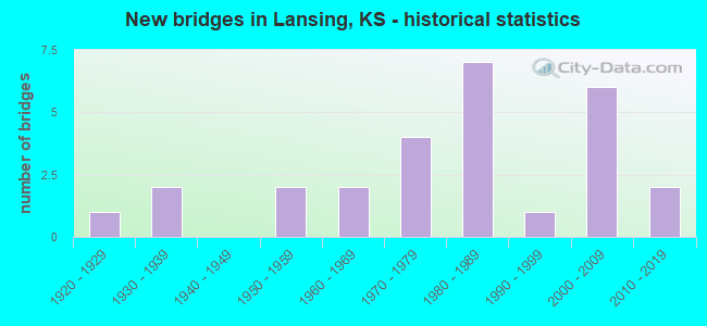
- New bridges - historical statistics
- 11920-1929
- 21930-1939
- 21950-1959
- 21960-1969
- 41970-1979
- 71980-1989
- 11990-1999
- 62000-2009
- 22010-2019

- Reconstructed bridges - Historical Statistics
- 21960-1969
- 01970-1979
- 01980-1989
- 11990-1999
- 12000-2009


- Bridge Condition - Deck
- 9.1%Very good
- 81.8%Good
- 4.5%Satisfactory
- 4.5%Fair

- Bridge Condition - Superstructure
- 13.6%Very good
- 54.5%Good
- 22.7%Satisfactory
- 9.1%Fair

- Bridge Condition - Substructure
- 18.2%Very good
- 59.1%Good
- 13.6%Satisfactory
- 9.1%Fair

- Bridge Condition - Channel
- 3.7%Very good
- 48.1%Good
- 44.4%Satisfactory
- 3.7%Fair

- Bridge Condition - Culverts
- 40.0%Good
- 60.0%Satisfactory
Find on map >> Show street view
Structure Number: 52012, Location: 3.0E 3.1N OF JARBALO (Lat: 39.246064, Lng: -95.013600), Route carried "on" structure: County highway 383, Year Built: 1937, Status: Posted for load, Structure Length: 0.62m (2.03ft), Average Daily Traffic: 615 (year 2013), Truck Traffic: 11%, Average Future Daily Traffic: 1,625 (year 2038), Features Intersected: UNNAMED STREAM, Facility Carried by Structure: HP-12 JARBALO Rd
Minimum Vertical Clearance: 30.47m (99.97ft), Kilometerpoint: 0.000, Lanes on structure: 2, Owner: County Highway Agency, Approaching Roadway Width: 7.6m (24.9ft), Material/Design: Steel, Design/Construction: Culvert, Number Of Spans In Main Unit: 1, Length of Maximum Span: 6.2m (20.3ft), Curb-To-Curb Width: 8.5m (27.9ft), Out-to-Out Width: 8.7m (28.5ft)
Condition: Channel: Satisfactory, Culverts: Satisfactory, Operating Rating: 90.5 metric tons, Method Used To Determine Operating Rating: Load Factor (LF), Inventory Rating: 68.2 metric tons, Method Used To Determine Inventory Rating: Load Factor (LF), Structural Evaluation: Equal to present minimum criteria, Deck Geometry: Somewhat better than minimum adequacy, Waterway Adequacy: Equal to present minimum criteria, Approach Roadway Alignment: Better than present minimum criteria, Designated Inspection Frequency: Every 24 months, Inspection Date: March 2020
Find on map >> Show street view
Structure Number: 52015, Location: 1.0N 3.2W OF FAIRMOUNT (Lat: 39.201381, Lng: -94.996614), Route carried "on" structure: County highway 384, Year Built: 2008, Status: Open, Structure Length: 4.36m (14.30ft), Average Daily Traffic: 1,715 (year 2013), Truck Traffic: 11%, Average Future Daily Traffic: 2,334 (year 2038), Design Load: HL 93, Features Intersected: LITTLESTRANGER CREEK, Facility Carried by Structure: HP-52 DEMPSEY RD
Minimum Vertical Clearance: 30.47m (99.97ft), Kilometerpoint: 0.000, Lanes on structure: 2, Owner: County Highway Agency, Approaching Roadway Width: 7.9m (25.9ft), Material/Design: Concrete continuous, Design/Construction: Slab, Number Of Spans In Main Unit: 3, Length of Maximum Span: 16.7m (54.8ft), Curb-To-Curb Width: 9.8m (32.2ft), Out-to-Out Width: 10.4m (34.1ft)
Condition: Deck: Good, Superstructure: Good, Substructure: Good, Channel: Good, Operating Rating: 58.3 metric tons, Method Used To Determine Operating Rating: Load and Resistance Factor Rating (LRFR) rating reported by rating factor(RF) method using HL-93 loadings, Inventory Rating: 45.0 metric tons, Method Used To Determine Inventory Rating: Load and Resistance Factor Rating (LRFR) rating reported by rating factor(RF) method using HL-93 loadings, Structural Evaluation: Better than present minimum criteria, Deck Geometry: Somewhat better than minimum adequacy, Waterway Adequacy: Equal to present desirable criteria, Approach Roadway Alignment: Equal to present desirable criteria, Designated Inspection Frequency: Every 24 months, Inspection Date: March 2020, Deck Structure Type: Concrete Cast-file-Place, Wearing Surface/Protective System: Wearing Surface: Integral Concrete
Find on map >> Show street view
Structure Number: 52029, Location: 4.0W 4.0N OF FAIRMOUNT (Lat: 39.244664, Lng: -95.012319), Route carried "on" structure: County highway 770, Year Built: 1971, Status: Posted for load, Structure Length: 0.67m (2.20ft), Average Daily Traffic: 1,300 (year 2013), Truck Traffic: 11%, Average Future Daily Traffic: 1,422 (year 2038), Design Load: H 15, Features Intersected: UNNAMED STREAM, Facility Carried by Structure: HP-36 187TH St.
Minimum Vertical Clearance: 7.92m (25.98ft), Kilometerpoint: 0.000, Lanes on structure: 2, Owner: County Highway Agency, Approaching Roadway Width: 8.5m (27.9ft), Material/Design: Steel, Design/Construction: Stringer/Multi-beam, Number Of Spans In Main Unit: 1, Length of Maximum Span: 6.4m (21.0ft), Curb-To-Curb Width: 9.4m (30.8ft), Out-to-Out Width: 9.9m (32.5ft)
Condition: Deck: Good, Superstructure: Fair, Substructure: Fair, Channel: Satisfactory, Operating Rating: 10.3 metric tons, Method Used To Determine Operating Rating: Load Factor (LF), Inventory Rating: 6.2 metric tons, Method Used To Determine Inventory Rating: Load Factor (LF), Structural Evaluation: High priority of corrective action, Deck Geometry: Somewhat better than minimum adequacy, Waterway Adequacy: Somewhat better than minimum adequacy, Approach Roadway Alignment: Equal to present desirable criteria, Bridge Posting: Required (Relationship of Operating Rating to Maximum Legal Load: 30.0 - 39.9% below), Designated Inspection Frequency: Every 24 months, Inspection Date: March 2020, Deck Structure Type: Concrete Cast-file-Place, Wearing Surface/Protective System: Wearing Surface: Bituminous
Find on map >> Show street view
Structure Number: 52051, Location: .1 N of McIntyre on 147th (Lat: 39.217111, Lng: -94.919072), Route carried "on" structure: City street 2177, Year Built: 1950, Year Reconstructed: 2003, Status: Open, Structure Length: 0.72m (2.36ft), Average Daily Traffic: 694 (year 2006), Truck Traffic: 2%, Average Future Daily Traffic: 730 (year 2039), Features Intersected: TRIB. TO NINE MILE CREEK, Facility Carried by Structure: LB-2, 147th Street
Minimum Vertical Clearance: 30.47m (99.97ft), Kilometerpoint: 0.000, Lanes on structure: 2, Owner: City or Municipal Highway Agency, Approaching Roadway Width: 7.3m (24.0ft), Material/Design: Steel, Design/Construction: Culvert, Number Of Spans In Main Unit: 1, Length of Maximum Span: 7.2m (23.6ft)
Condition: Channel: Good, Culverts: Good, Inventory Rating: 24.8 metric tons, Method Used To Determine Inventory Rating: Load Factor (LF), Structural Evaluation: Equal to present minimum criteria, Waterway Adequacy: Equal to present minimum criteria, Approach Roadway Alignment: Equal to present desirable criteria, Designated Inspection Frequency: Every 24 months, Inspection Date: Febuary 2022
Find on map >> Show street view
Structure Number: 52052, Location: .2 E of 147th on McIntyre (Lat: 39.215983, Lng: -94.915000), Route carried "on" structure: City street 2178, Year Built: 2000, Status: Open, Structure Length: 3.09m (10.14ft), Average Daily Traffic: 694 (year 2006), Truck Traffic: 2%, Average Future Daily Traffic: 730 (year 2039), Design Load: HS 20, Features Intersected: TRIB. TO NINE MILE CREEK, Facility Carried by Structure: LB-3 McIntyre Rd.
Minimum Vertical Clearance: 30.47m (99.97ft), Kilometerpoint: 0.000, Lanes on structure: 2, Owner: City or Municipal Highway Agency, Approaching Roadway Width: 9.9m (32.5ft), Skew: 3 degrees, Material/Design: Concrete continuous, Design/Construction: Slab, Number Of Spans In Main Unit: 3, Length of Maximum Span: 12.2m (40.0ft), Curb-To-Curb Width: 9.8m (32.2ft), Out-to-Out Width: 10.4m (34.1ft)
Condition: Deck: Good, Superstructure: Good, Substructure: Good, Channel: Good, Operating Rating: 61.3 metric tons, Method Used To Determine Operating Rating: Load Factor (LF), Inventory Rating: 36.3 metric tons, Method Used To Determine Inventory Rating: Load Factor (LF), Structural Evaluation: Better than present minimum criteria, Deck Geometry: Equal to present minimum criteria, Waterway Adequacy: Equal to present desirable criteria, Approach Roadway Alignment: Equal to present desirable criteria, Designated Inspection Frequency: Every 24 months, Inspection Date: Febuary 2022, Deck Structure Type: Concrete Cast-file-Place, Wearing Surface/Protective System: Wearing Surface: Monolithic Concrete, Deck Protection: Epoxy Coated Reinforcing
Find on map >> Show street view
Structure Number: 521069304063, Location: 4.0E 8.0N OF TONGANOXIE (Lat: 39.226650, Lng: -95.005597), Route carried "on" structure: County highway , Year Built: 1980, Status: Open, Structure Length: 3.44m (11.29ft), Average Daily Traffic: 41 (year 2013), Truck Traffic: 10%, Average Future Daily Traffic: 79 (year 2038), Design Load: H 20, Features Intersected: TRIB. TO STRANGER CREEK, Facility Carried by Structure: HP-41 SEYMOUR RD
Minimum Vertical Clearance: 30.47m (99.97ft), Kilometerpoint: 0.000, Lanes on structure: 2, Owner: County Highway Agency, Approaching Roadway Width: 6.2m (20.3ft), Material/Design: Concrete continuous, Design/Construction: Slab, Number Of Spans In Main Unit: 3, Length of Maximum Span: 13.1m (43.0ft), Curb-To-Curb Width: 7.9m (25.9ft), Out-to-Out Width: 8.5m (27.9ft)
Condition: Deck: Good, Superstructure: Good, Substructure: Good, Channel: Satisfactory, Operating Rating: 45.2 metric tons, Method Used To Determine Operating Rating: Load Factor (LF), Inventory Rating: 27.0 metric tons, Method Used To Determine Inventory Rating: Load Factor (LF), Structural Evaluation: Equal to present minimum criteria, Deck Geometry: Equal to present minimum criteria, Waterway Adequacy: Better than present minimum criteria, Approach Roadway Alignment: Equal to present desirable criteria, Designated Inspection Frequency: Every 24 months, Inspection Date: March 2020, Other Special Inspection Date: November 2020, Deck Structure Type: Concrete Cast-file-Place
Find on map >> Show street view
Structure Number: 521069404082, Location: 3.4E 0.8N OF JARBALO (Lat: 39.213375, Lng: -95.005069), Route carried "on" structure: County highway , Year Built: 1930, Status: Posted for load, Structure Length: 1.20m (3.94ft), Average Daily Traffic: 43 (year 2013), Truck Traffic: 5%, Average Future Daily Traffic: 47 (year 2038), Features Intersected: TRIB. TO LITTLE STRANGER, Facility Carried by Structure: HP-51 Jamison Rd.
Minimum Vertical Clearance: 30.47m (99.97ft), Kilometerpoint: 0.000, Lanes on structure: 1, Owner: County Highway Agency, Approaching Roadway Width: 4.8m (15.7ft), Material/Design: Concrete, Design/Construction: Arch - Deck, Number Of Spans In Main Unit: 1, Length of Maximum Span: 11.4m (37.4ft), Curb-To-Curb Width: 4.1m (13.5ft), Out-to-Out Width: 4.6m (15.1ft)
Condition: Deck: Fair, Superstructure: Fair, Substructure: Fair, Channel: Satisfactory, Operating Rating: 24.3 metric tons, Method Used To Determine Operating Rating: Load Factor (LF), Inventory Rating: 19.8 metric tons, Method Used To Determine Inventory Rating: Load Factor (LF), Structural Evaluation: Somewhat better than minimum adequacy, Deck Geometry: Somewhat better than minimum adequacy, Waterway Adequacy: Equal to present minimum criteria, Approach Roadway Alignment: Somewhat better than minimum adequacy, Bridge Posting: Required (Relationship of Operating Rating to Maximum Legal Load: 20.0 - 29.9% below), Designated Inspection Frequency: Every 24 months, Inspection Date: March 2020, Deck Structure Type: Concrete Cast-file-Place
Find on map >> Show street view
Structure Number: 521069504, Location: 1.0N 6.4E OF SPRINGDALE (Lat: 39.273758, Lng: -95.004300), Route carried "on" structure: County highway 2610, Year Built: 2014, Status: Open, Structure Length: 3.12m (10.24ft), Average Daily Traffic: 24 (year 2013), Average Future Daily Traffic: 110 (year 2038), Design Load: HS 20+Mod, Features Intersected: TRIB. TO LITTLE STRANGER, Facility Carried by Structure: HP-25 HIGH PRAIRIE
Minimum Vertical Clearance: 30.47m (99.97ft), Kilometerpoint: 0.000, Lanes on structure: 2, Owner: County Highway Agency, Approaching Roadway Width: 7.3m (24.0ft), Material/Design: Concrete continuous, Design/Construction: Slab, Number Of Spans In Main Unit: 3, Length of Maximum Span: 12.2m (40.0ft), Curb-To-Curb Width: 8.5m (27.9ft), Out-to-Out Width: 9.1m (29.9ft)
Condition: Deck: Very good, Superstructure: Very good, Substructure: Very good, Channel: Very good, Operating Rating: 90.2 metric tons, Method Used To Determine Operating Rating: Load and Resistance Factor (LRFR), Inventory Rating: 53.9 metric tons, Method Used To Determine Inventory Rating: Load and Resistance Factor (LRFR), Structural Evaluation: Equal to present desirable criteria, Deck Geometry: Better than present minimum criteria, Waterway Adequacy: Equal to present desirable criteria, Approach Roadway Alignment: Equal to present desirable criteria, Designated Inspection Frequency: Every 24 months, Inspection Date: March 2020, Deck Structure Type: Concrete Cast-file-Place
Find on map >> Show street view
Structure Number: 521069504061, Location: 3.5W 1.9N OF JARBALO (Lat: 39.229575, Lng: -95.003192), Route carried "on" structure: County highway , Year Built: 1988, Status: Open, Structure Length: 3.70m (12.14ft), Average Daily Traffic: 46 (year 2013), Truck Traffic: 16%, Average Future Daily Traffic: 153 (year 2038), Design Load: H 20, Features Intersected: TRIB. TO LITTLE STRANGER, Facility Carried by Structure: HP-40 183rd St.
Minimum Vertical Clearance: 30.47m (99.97ft), Kilometerpoint: 0.000, Lanes on structure: 2, Owner: County Highway Agency, Approaching Roadway Width: 6.2m (20.3ft), Skew: 3 degrees, Material/Design: Concrete continuous, Design/Construction: Slab, Number Of Spans In Main Unit: 3, Length of Maximum Span: 14.6m (47.9ft), Curb-To-Curb Width: 7.3m (24.0ft), Out-to-Out Width: 7.9m (25.9ft)
Condition: Deck: Good, Superstructure: Good, Substructure: Good, Channel: Satisfactory, Operating Rating: 56.3 metric tons, Method Used To Determine Operating Rating: Load Factor (LF), Inventory Rating: 33.7 metric tons, Method Used To Determine Inventory Rating: Load Factor (LF), Structural Evaluation: Better than present minimum criteria, Deck Geometry: Equal to present minimum criteria, Waterway Adequacy: Better than present minimum criteria, Approach Roadway Alignment: Equal to present desirable criteria, Designated Inspection Frequency: Every 24 months, Inspection Date: March 2020, Other Special Inspection Date: November 2020, Deck Structure Type: Concrete Cast-file-Place
Find on map >> Show street view
Structure Number: 52106980404, Location: 4.2W OF LANSING (Lat: 39.244786, Lng: -94.998536), Route carried "on" structure: County highway , Year Built: 1981, Status: Open, Structure Length: 3.12m (10.24ft), Average Daily Traffic: 103 (year 2013), Truck Traffic: 16%, Average Future Daily Traffic: 143 (year 2038), Design Load: H 20, Features Intersected: TRIB.TO LITTLE STRANGER, Facility Carried by Structure: HP-57 STRANGER
Minimum Vertical Clearance: 30.47m (99.97ft), Kilometerpoint: 0.000, Lanes on structure: 2, Owner: County Highway Agency, Approaching Roadway Width: 7.4m (24.3ft), Material/Design: Concrete continuous, Design/Construction: Slab, Number Of Spans In Main Unit: 3, Length of Maximum Span: 12.2m (40.0ft), Curb-To-Curb Width: 7.9m (25.9ft), Out-to-Out Width: 8.5m (27.9ft)
Condition: Deck: Good, Superstructure: Satisfactory, Substructure: Good, Channel: Good, Operating Rating: 49.4 metric tons, Method Used To Determine Operating Rating: Load Factor (LF), Inventory Rating: 29.6 metric tons, Method Used To Determine Inventory Rating: Load Factor (LF), Structural Evaluation: Equal to present minimum criteria, Deck Geometry: Somewhat better than minimum adequacy, Waterway Adequacy: Better than present minimum criteria, Approach Roadway Alignment: Equal to present desirable criteria, Designated Inspection Frequency: Every 24 months, Inspection Date: March 2020, Other Special Inspection Date: November 2020, Deck Structure Type: Concrete Cast-file-Place
Find on map >> Show street view
Structure Number: 5210732041, Location: 0.5N 2.0W OF FAIRMOUNT (Lat: 39.201156, Lng: -94.973153), Route carried "on" structure: County highway , Year Built: 1987, Status: Open, Structure Length: 0.92m (3.02ft), Average Daily Traffic: 63 (year 2013), Truck Traffic: 16%, Average Future Daily Traffic: 96 (year 2038), Design Load: H 20, Features Intersected: TRIB. TO STRANGER CREEK, Facility Carried by Structure: HP-49 DEMPSEY RD
Minimum Vertical Clearance: 30.47m (99.97ft), Kilometerpoint: 0.000, Lanes on structure: 2, Owner: County Highway Agency, Approaching Roadway Width: 7.3m (24.0ft), Material/Design: Steel, Design/Construction: Stringer/Multi-beam, Number Of Spans In Main Unit: 1, Length of Maximum Span: 9.0m (29.5ft), Curb-To-Curb Width: 7.2m (23.6ft), Out-to-Out Width: 7.3m (24.0ft)
Condition: Deck: Satisfactory, Superstructure: Satisfactory, Substructure: Satisfactory, Channel: Fair, Operating Rating: 40.5 metric tons, Method Used To Determine Operating Rating: Load Factor (LF), Inventory Rating: 29.7 metric tons, Method Used To Determine Inventory Rating: Load Factor (LF), Structural Evaluation: Equal to present minimum criteria, Deck Geometry: Somewhat better than minimum adequacy, Waterway Adequacy: Somewhat better than minimum adequacy, Approach Roadway Alignment: Equal to present desirable criteria, Designated Inspection Frequency: Every 24 months, Inspection Date: March 2020, Deck Structure Type: Corrugated Steel, Wearing Surface/Protective System: Wearing Surface: Bituminous
Find on map >> Show street view
Structure Number: 5210736041, Location: 0.5N 1.7W OF FAIRMOUNT (Lat: 39.201175, Lng: -94.967447), Route carried "on" structure: County highway , Year Built: 1987, Status: Open, Structure Length: 0.94m (3.08ft), Average Daily Traffic: 63 (year 2013), Truck Traffic: 16%, Average Future Daily Traffic: 100 (year 2038), Design Load: H 20, Features Intersected: TRIB. TO STRANGER CK., Facility Carried by Structure: HP-50 DEMPSEY RD
Minimum Vertical Clearance: 30.47m (99.97ft), Kilometerpoint: 0.000, Lanes on structure: 2, Owner: County Highway Agency, Approaching Roadway Width: 6.5m (21.3ft), Material/Design: Steel, Design/Construction: Stringer/Multi-beam, Number Of Spans In Main Unit: 1, Length of Maximum Span: 9.1m (29.9ft), Curb-To-Curb Width: 7.2m (23.6ft), Out-to-Out Width: 7.3m (24.0ft)
Condition: Deck: Good, Superstructure: Satisfactory, Substructure: Good, Channel: Satisfactory, Operating Rating: 40.5 metric tons, Method Used To Determine Operating Rating: Allowable Stress (AS), Inventory Rating: 29.7 metric tons, Method Used To Determine Inventory Rating: Allowable Stress (AS), Structural Evaluation: Equal to present minimum criteria, Deck Geometry: Somewhat better than minimum adequacy, Waterway Adequacy: Equal to present minimum criteria, Approach Roadway Alignment: Equal to present desirable criteria, Designated Inspection Frequency: Every 24 months, Inspection Date: March 2020, Deck Structure Type: Corrugated Steel, Wearing Surface/Protective System: Wearing Surface: Bituminous
Find on map >> Show street view
Structure Number: 521077004024, Location: 2.0W OF LANSING (Lat: 39.253050, Lng: -94.937494), Route carried "on" structure: County highway , Year Built: 1969, Status: Posted for load, Structure Length: 0.85m (2.79ft), Average Daily Traffic: 257 (year 2013), Truck Traffic: 16%, Average Future Daily Traffic: 218 (year 2038), Design Load: H 15, Features Intersected: SEVEN MILE CREEK, Facility Carried by Structure: D-16 155TH STREET
Minimum Vertical Clearance: 30.47m (99.97ft), Kilometerpoint: 0.000, Lanes on structure: 2, Owner: County Highway Agency, Approaching Roadway Width: 6.5m (21.3ft), Material/Design: Steel, Design/Construction: Stringer/Multi-beam, Number Of Spans In Main Unit: 1, Length of Maximum Span: 8.2m (26.9ft), Curb-To-Curb Width: 7.2m (23.6ft), Out-to-Out Width: 7.3m (24.0ft)
Condition: Deck: Good, Superstructure: Good, Substructure: Satisfactory, Channel: Satisfactory, Operating Rating: 23.3 metric tons, Method Used To Determine Operating Rating: Load Factor (LF), Inventory Rating: 14.0 metric tons, Method Used To Determine Inventory Rating: Load Factor (LF), Structural Evaluation: Meets minimum limits, Deck Geometry: Meets minimum limits, Waterway Adequacy: Equal to present minimum criteria, Approach Roadway Alignment: Equal to present desirable criteria, Bridge Posting: Required (Relationship of Operating Rating to Maximum Legal Load: 10.0 - 19.9% below), Designated Inspection Frequency: Every 24 months, Inspection Date: March 2020, Deck Structure Type: Concrete Cast-file-Place
Find on map >> Show street view
Structure Number: 521079004028, Location: .2 N of Mary St. on 147th (Lat: 39.247986, Lng: -94.919058), Route carried "on" structure: City street , Year Built: 1975, Status: Posted for load, Structure Length: 1.13m (3.71ft), Average Daily Traffic: 2,098 (year 2006), Truck Traffic: 6%, Average Future Daily Traffic: 3,000 (year 2039), Design Load: H 20, Features Intersected: SEVEN MILE CREEK, Facility Carried by Structure: LB-1, 147th DeSoto
Minimum Vertical Clearance: 30.47m (99.97ft), Kilometerpoint: 0.000, Lanes on structure: 2, Owner: City or Municipal Highway Agency, Approaching Roadway Width: 7.3m (24.0ft), Material/Design: Steel, Design/Construction: Stringer/Multi-beam, Number Of Spans In Main Unit: 1, Length of Maximum Span: 8.2m (26.9ft), Curb-To-Curb Width: 7.2m (23.6ft), Out-to-Out Width: 7.3m (24.0ft)
Condition: Deck: Good, Superstructure: Satisfactory, Substructure: Satisfactory, Channel: Satisfactory, Operating Rating: 31.7 metric tons, Method Used To Determine Operating Rating: Load Factor (LF), Inventory Rating: 18.1 metric tons, Method Used To Determine Inventory Rating: Load Factor (LF), Structural Evaluation: Somewhat better than minimum adequacy, Deck Geometry: High priority of replacement, Waterway Adequacy: Equal to present minimum criteria, Approach Roadway Alignment: Equal to present desirable criteria, Length Of Structure Improvement: 2.29m (7.51ft), Designated Inspection Frequency: Every 24 months, Inspection Date: Febuary 2022, Bridge Improvement Cost: $300,000, Roadway Improvement Cost: $350,000, Total Project Cost: $925,000, Deck Structure Type: Concrete Cast-file-Place, Wearing Surface/Protective System: Wearing Surface: Bituminous
Find on map >> Show street view
Structure Number: 52108110406, Location: .1 E of K-7 on Gilman Rd. (Lat: 39.230644, Lng: -94.898222), Route carried "on" structure: City street , Year Built: 2001, Status: Open, Structure Length: 4.00m (13.12ft), Average Daily Traffic: 430 (year 2006), Truck Traffic: 6%, Average Future Daily Traffic: 500 (year 2039), Design Load: HS 20, Features Intersected: NINE MILE CK., Facility Carried by Structure: LB-5, Gilman Rd.
Minimum Vertical Clearance: 30.47m (99.97ft), Kilometerpoint: 0.000, Lanes on structure: 2, Owner: City or Municipal Highway Agency, Approaching Roadway Width: 10.9m (35.8ft), Material/Design: Concrete continuous, Design/Construction: Slab, Number Of Spans In Main Unit: 3, Length of Maximum Span: 16.0m (52.5ft), Curb or Sidewalk Widths: Left: 0.0m, Right: 1.8m (5.9ft), Curb-To-Curb Width: 11.0m (36.1ft), Out-to-Out Width: 13.4m (44.0ft)
Condition: Deck: Good, Superstructure: Good, Substructure: Good, Channel: Good, Operating Rating: 91.6 metric tons, Method Used To Determine Operating Rating: Load Factor (LF), Inventory Rating: 54.4 metric tons, Method Used To Determine Inventory Rating: Load Factor (LF), Structural Evaluation: Better than present minimum criteria, Deck Geometry: Better than present minimum criteria, Waterway Adequacy: Equal to present desirable criteria, Approach Roadway Alignment: Equal to present desirable criteria, Designated Inspection Frequency: Every 24 months, Inspection Date: Febuary 2022, Deck Structure Type: Concrete Cast-file-Place, Wearing Surface/Protective System: Wearing Surface: Monolithic Concrete, Deck Protection: Epoxy Coated Reinforcing
Find on map >> Show street view
Structure Number: 52108170404, Location: .8 mi East of K-7 on Mary (Lat: 39.245147, Lng: -94.886744), Route carried "on" structure: City street , Year Built: 2000, Status: Open, Structure Length: 4.59m (15.06ft), Average Daily Traffic: 1,105 (year 2006), Truck Traffic: 6%, Average Future Daily Traffic: 500 (year 2039), Design Load: HS 20, Features Intersected: NINE MILE CREEK, Facility Carried by Structure: LB-4, Mary Street
Minimum Vertical Clearance: 30.47m (99.97ft), Kilometerpoint: 0.000, Lanes on structure: 2, Owner: City or Municipal Highway Agency, Approaching Roadway Width: 7.3m (24.0ft), Material/Design: Concrete continuous, Design/Construction: Slab, Number Of Spans In Main Unit: 3, Length of Maximum Span: 17.9m (58.7ft), Curb or Sidewalk Widths: Left: 0.0m, Right: 1.8m (5.9ft), Curb-To-Curb Width: 8.5m (27.9ft), Out-to-Out Width: 11.0m (36.1ft)
Condition: Deck: Good, Superstructure: Good, Substructure: Good, Channel: Good, Operating Rating: 89.4 metric tons, Method Used To Determine Operating Rating: Load Factor (LF), Inventory Rating: 53.5 metric tons, Method Used To Determine Inventory Rating: Load Factor (LF), Structural Evaluation: Better than present minimum criteria, Deck Geometry: Somewhat better than minimum adequacy, Waterway Adequacy: Equal to present desirable criteria, Approach Roadway Alignment: Equal to present desirable criteria, Designated Inspection Frequency: Every 24 months, Inspection Date: Febuary 2022, Deck Structure Type: Concrete Cast-file-Place, Wearing Surface/Protective System: Wearing Surface: Monolithic Concrete, Deck Protection: Epoxy Coated Reinforcing
Find on map >> Show street view
Structure Number: 521085504063, Location: 1.5E OF LANSING (Lat: 39.225094, Lng: -94.853697), Route carried "on" structure: County highway , Year Built: 1982, Status: Open, Structure Length: 3.44m (11.29ft), Average Daily Traffic: 80 (year 2013), Truck Traffic: 16%, Average Future Daily Traffic: 211 (year 2038), Design Load: H 20, Features Intersected: TRIB. TO MISSOURI RIVER, Facility Carried by Structure: D-34 119TH STREET
Minimum Vertical Clearance: 30.47m (99.97ft), Kilometerpoint: 0.000, Lanes on structure: 2, Owner: County Highway Agency, Approaching Roadway Width: 6.2m (20.3ft), Material/Design: Concrete continuous, Design/Construction: Slab, Number Of Spans In Main Unit: 3, Length of Maximum Span: 13.4m (44.0ft), Curb-To-Curb Width: 7.3m (24.0ft), Out-to-Out Width: 7.9m (25.9ft)
Condition: Deck: Good, Superstructure: Good, Substructure: Good, Channel: Satisfactory, Operating Rating: 41.4 metric tons, Method Used To Determine Operating Rating: Load Factor (LF), Inventory Rating: 24.8 metric tons, Method Used To Determine Inventory Rating: Load Factor (LF), Structural Evaluation: Equal to present minimum criteria, Deck Geometry: Equal to present minimum criteria, Waterway Adequacy: Equal to present desirable criteria, Approach Roadway Alignment: Better than present minimum criteria, Designated Inspection Frequency: Every 24 months, Inspection Date: March 2020, Deck Structure Type: Concrete Cast-file-Place
Find on map >> Show street view
Structure Number: 5151505200001, Location: .1 N of Mary on Bitterswt (Lat: 39.248967, Lng: -94.909528), Route carried "on" structure: City street , Year Built: 2008, Status: Open, Structure Length: 9.60m (31.50ft), Average Daily Traffic: 1,000 (year 2008), Truck Traffic: 3%, Average Future Daily Traffic: 2,000 (year 2039), Design Load: HS 20, Features Intersected: Seven Mile Creek, Facility Carried by Structure: LB-6 Bittersweet S
Minimum Vertical Clearance: 30.47m (99.97ft), Kilometerpoint: 0.000, Lanes on structure: 2, Owner: City or Municipal Highway Agency, Approaching Roadway Width: 8.5m (27.9ft), Material/Design: Prestressed concrete continuous, Design/Construction: Stringer/Multi-beam, Number Of Spans In Main Unit: 3, Length of Maximum Span: 31.7m (104.0ft), Curb or Sidewalk Widths: Left: 0.0m, Right: 3.4m (11.2ft), Curb-To-Curb Width: 8.5m (27.9ft), Out-to-Out Width: 12.5m (41.0ft)
Condition: Deck: Good, Superstructure: Good, Substructure: Good, Channel: Good, Operating Rating: 30.1 metric tons, Method Used To Determine Operating Rating: Load and Resistance Factor Rating (LRFR) rating reported by rating factor(RF) method using HL-93 loadings, Inventory Rating: 23.3 metric tons, Method Used To Determine Inventory Rating: Load and Resistance Factor Rating (LRFR) rating reported by rating factor(RF) method using HL-93 loadings, Structural Evaluation: Equal to present minimum criteria, Deck Geometry: Somewhat better than minimum adequacy, Waterway Adequacy: Equal to present desirable criteria, Approach Roadway Alignment: Equal to present desirable criteria, Designated Inspection Frequency: Every 24 months, Inspection Date: Febuary 2022, Deck Structure Type: Concrete Cast-file-Place, Wearing Surface/Protective System: Deck Protection: Epoxy Coated Reinforcing
Find on map >> Show street view
Structure Number: 51515052000011, Location: Main Ent. to Lansing Park (Lat: 39.231669, Lng: -94.942650), Route carried "on" structure: City street , Year Built: 2011, Status: Open, Structure Length: 2.07m (6.79ft), Average Daily Traffic: 50 (year 2011), Truck Traffic: 2%, Average Future Daily Traffic: 100 (year 2039), Design Load: HS 20, Features Intersected: South Basin, Facility Carried by Structure: LB-7 Main Entrance
Minimum Vertical Clearance: 30.47m (99.97ft), Kilometerpoint: 0.000, Lanes on structure: 2, Owner: City or Municipal Highway Agency, Approaching Roadway Width: 7.3m (24.0ft), Material/Design: Steel, Design/Construction: Truss - Thru, Number Of Spans In Main Unit: 1, Length of Maximum Span: 19.2m (63.0ft), Curb or Sidewalk Widths: Left: 0.0m, Right: 1.5m (4.9ft), Curb-To-Curb Width: 7.3m (24.0ft), Out-to-Out Width: 8.8m (28.9ft)
Condition: Deck: Good, Superstructure: Good, Substructure: Good, Channel: Good, Operating Rating: 68.6 metric tons, Method Used To Determine Operating Rating: Load Factor (LF), Inventory Rating: 41.2 metric tons, Method Used To Determine Inventory Rating: Load Factor (LF), Structural Evaluation: Better than present minimum criteria, Deck Geometry: Equal to present minimum criteria, Waterway Adequacy: Equal to present desirable criteria, Approach Roadway Alignment: Equal to present desirable criteria, Designated Inspection Frequency: Every 24 months, Critical Feature Inspection Frequency: Every 24 months, Inspection Date: June 2020, Critical Feature Inspection Date: April 2020, Deck Structure Type: Corrugated Steel, Wearing Surface/Protective System: Wearing Surface: Bituminous
Find on map >> Show street view
Structure Number: 999900500520541, Location: 1.84 MILES SE US-73 (Lat: 39.258889, Lng: -94.881111), Route carried "on" structure: State highway 5, Year Built: 1974, Status: Open, Structure Length: 2.81m (9.22ft), Average Daily Traffic: 2,160 (year 2020), Truck Traffic: 12%, Average Future Daily Traffic: 3,752 (year 2041), Design Load: H 20, Features Intersected: NINE MILE CREEK
Minimum Vertical Clearance: 30.47m (99.97ft), Kilometerpoint: 9.175, Lanes on structure: 2, Owner: State Highway Agency, Approaching Roadway Width: 7.9m (25.9ft), Material/Design: Steel continuous, Design/Construction: Stringer/Multi-beam, Number Of Spans In Main Unit: 3, Length of Maximum Span: 12.2m (40.0ft), Curb-To-Curb Width: 8.5m (27.9ft), Out-to-Out Width: 9.1m (29.9ft)
Condition: Deck: Good, Superstructure: Satisfactory, Substructure: Good, Channel: Good, Operating Rating: 40.8 metric tons, Method Used To Determine Operating Rating: Load Factor (LF), Inventory Rating: 24.5 metric tons, Method Used To Determine Inventory Rating: Load Factor (LF), Structural Evaluation: Equal to present minimum criteria, Deck Geometry: Meets minimum limits, Waterway Adequacy: High priority of corrective action, Approach Roadway Alignment: Somewhat better than minimum adequacy, Length Of Structure Improvement: 9.22m (30.25ft), Designated Inspection Frequency: Every 24 months, Inspection Date: June 2021, Deck Structure Type: Concrete Cast-file-Place, Wearing Surface/Protective System: Wearing Surface: Low Slump Concrete
Find on map >> Show street view
Structure Number: 999900500520561, Location: 1.65 MILES SE US-73 (Lat: 39.261667, Lng: -94.881389), Route carried "on" structure: State highway 5, Year Built: 1975, Year Reconstructed: 2006, Status: Open, Structure Length: 1.70m (5.58ft), Average Daily Traffic: 2,160 (year 2020), Truck Traffic: 12%, Average Future Daily Traffic: 3,752 (year 2041), Design Load: H 20, Features Intersected: 7 MILE CREEK
Minimum Vertical Clearance: 30.47m (99.97ft), Kilometerpoint: 9.502, Lanes on structure: 2, Owner: State Highway Agency, Approaching Roadway Width: 7.9m (25.9ft), Material/Design: Concrete, Design/Construction: Slab, Number Of Spans In Main Unit: 1, Length of Maximum Span: 17.0m (55.8ft), Curb-To-Curb Width: 9.1m (29.9ft), Out-to-Out Width: 9.8m (32.2ft)
Condition: Deck: Very good, Superstructure: Very good, Substructure: Very good, Channel: Good, Operating Rating: 65.8 metric tons, Method Used To Determine Operating Rating: Load Factor (LF), Inventory Rating: 39.4 metric tons, Method Used To Determine Inventory Rating: Load Factor (LF), Structural Evaluation: Equal to present desirable criteria, Deck Geometry: Meets minimum limits, Waterway Adequacy: High priority of corrective action, Approach Roadway Alignment: High priority of replacement, Length Of Structure Improvement: 5.57m (18.27ft), Designated Inspection Frequency: Every 24 months, Inspection Date: June 2021, Wearing Surface/Protective System: Wearing Surface: Monolithic Concrete, Deck Protection: Epoxy Coated Reinforcing
Find on map >> Show street view
Structure Number: 999900500520691, Location: 2.97 MI NW WYANDOTTE COLN (Lat: 39.224444, Lng: -94.862778), Route carried "on" structure: State highway 5, Year Built: 1992, Status: Open, Structure Length: 0.76m (2.49ft), Average Daily Traffic: 2,285 (year 2020), Truck Traffic: 12%, Average Future Daily Traffic: 3,970 (year 2041), Design Load: HS 20, Features Intersected: SEVENMILE CREEK DRAINAGE
Minimum Vertical Clearance: 30.47m (99.97ft), Kilometerpoint: 4.757, Lanes on structure: 2, Owner: State Highway Agency, Approaching Roadway Width: 7.3m (24.0ft), Material/Design: Concrete, Design/Construction: Culvert, Number Of Spans In Main Unit: 2, Length of Maximum Span: 3.7m (12.1ft), Curb-To-Curb Width: 11.0m (36.1ft), Out-to-Out Width: 35.2m (115.5ft)
Condition: Channel: Satisfactory, Culverts: Good, Inventory Rating: 34.6 metric tons, Method Used To Determine Inventory Rating: Load Factor (LF), Structural Evaluation: Better than present minimum criteria, Deck Geometry: Somewhat better than minimum adequacy, Waterway Adequacy: Equal to present minimum criteria, Approach Roadway Alignment: Meets minimum limits, Length Of Structure Improvement: 2.48m (8.14ft), Designated Inspection Frequency: Every 24 months, Inspection Date: June 2021, Deck Structure Type: Concrete Cast-file-Place, Wearing Surface/Protective System: Wearing Surface: Bituminous
Find on map >> Show street view
Structure Number: 999907300520101, Location: 1.78 MILES N WY CO/LN (Lat: 39.228889, Lng: -94.900000), Route carried "on" structure: US 73, Year Built: 1968, Status: Open, Structure Length: 4.04m (13.25ft), Average Daily Traffic: 11,832 (year 2020), Truck Traffic: 4%, Average Future Daily Traffic: 13,603 (year 2041), Design Load: HS 20, Features Intersected: NINE MILE CREEK
Minimum Vertical Clearance: 30.47m (99.97ft), Kilometerpoint: 3.013, Lanes on structure: 2, Base Highway Network: Yes, Owner: State Highway Agency, Approaching Roadway Width: 12.2m (40.0ft), Material/Design: Concrete continuous, Design/Construction: Slab, Number Of Spans In Main Unit: 3, Length of Maximum Span: 15.8m (51.8ft), Curb-To-Curb Width: 12.2m (40.0ft), Out-to-Out Width: 12.8m (42.0ft)
Condition: Deck: Good, Superstructure: Good, Substructure: Very good, Channel: Good, Operating Rating: 64.4 metric tons, Method Used To Determine Operating Rating: Load Factor (LF), Inventory Rating: 38.1 metric tons, Method Used To Determine Inventory Rating: Load Factor (LF), Structural Evaluation: Better than present minimum criteria, Deck Geometry: Better than present minimum criteria, Waterway Adequacy: Better than present minimum criteria, Approach Roadway Alignment: Equal to present desirable criteria, Length Of Structure Improvement: 13.25m (43.47ft), Designated Inspection Frequency: Every 24 months, Inspection Date: June 2021, Deck Structure Type: Concrete Cast-file-Place, Wearing Surface/Protective System: Wearing Surface: Epoxy Overlay
Find on map >> Show street view
Structure Number: 999907300520551, Location: 1.69 MILES N WY COLINE (Lat: 39.225278, Lng: -94.900000), Route carried "on" structure: US 73, Year Built: 1950, Year Reconstructed: 1968, Status: Open, Structure Length: 0.75m (2.46ft), Average Daily Traffic: 11,832 (year 2020), Truck Traffic: 4%, Average Future Daily Traffic: 13,603 (year 2041), Design Load: H 20, Features Intersected: NINE MILE CREEK DRAINAGE
Minimum Vertical Clearance: 30.47m (99.97ft), Kilometerpoint: 2.630, Lanes on structure: 4, Base Highway Network: Yes, Owner: State Highway Agency, Approaching Roadway Width: 24.4m (80.1ft), Skew: 21 degrees, Material/Design: Steel, Design/Construction: Culvert, Number Of Spans In Main Unit: 1, Length of Maximum Span: 6.1m (20.0ft), Curb-To-Curb Width: 24.4m (80.1ft), Out-to-Out Width: 51.8m (169.9ft)
Condition: Channel: Satisfactory, Culverts: Satisfactory, Operating Rating: 35.4 metric tons, Method Used To Determine Operating Rating: Load Factor (LF), Inventory Rating: 28.1 metric tons, Method Used To Determine Inventory Rating: Load Factor (LF), Structural Evaluation: Equal to present minimum criteria, Deck Geometry: Superior to present desirable criteria, Waterway Adequacy: Equal to present minimum criteria, Approach Roadway Alignment: Equal to present desirable criteria, Length Of Structure Improvement: 2.45m (8.04ft), Designated Inspection Frequency: Every 24 months, Inspection Date: June 2021, Deck Structure Type: Corrugated Steel, Wearing Surface/Protective System: Wearing Surface: Bituminous
Find on map >> Show street view
Structure Number: 999907300520621, Location: 1.79 MI N WY CO LINE (Lat: 39.228889, Lng: -94.900278), Route carried "on" structure: US 73, Year Built: 1985, Status: Open, Structure Length: 4.04m (13.25ft), Average Daily Traffic: 11,832 (year 2020), Truck Traffic: 4%, Average Future Daily Traffic: 13,603 (year 2041), Design Load: HS 20, Features Intersected: NINE MILE CREEK
Minimum Vertical Clearance: 30.47m (99.97ft), Kilometerpoint: 3.011, Lanes on structure: 2, Base Highway Network: Yes, Owner: State Highway Agency, Approaching Roadway Width: 12.2m (40.0ft), Material/Design: Concrete continuous, Design/Construction: Slab, Number Of Spans In Main Unit: 3, Length of Maximum Span: 15.8m (51.8ft), Curb-To-Curb Width: 12.2m (40.0ft), Out-to-Out Width: 12.8m (42.0ft)
Condition: Deck: Good, Superstructure: Good, Substructure: Good, Channel: Good, Operating Rating: 60.8 metric tons, Method Used To Determine Operating Rating: Load Factor (LF), Inventory Rating: 36.3 metric tons, Method Used To Determine Inventory Rating: Load Factor (LF), Structural Evaluation: Better than present minimum criteria, Deck Geometry: Better than present minimum criteria, Waterway Adequacy: Equal to present desirable criteria, Approach Roadway Alignment: Equal to present desirable criteria, Length Of Structure Improvement: 13.26m (43.50ft), Designated Inspection Frequency: Every 24 months, Inspection Date: June 2021, Wearing Surface/Protective System: Wearing Surface: Low Slump Concrete, Deck Protection: Epoxy Coated Reinforcing
Find on map >> Show street view
Structure Number: 999907300520811, Location: 1.75 MI S K-5 (Lat: 39.251111, Lng: -94.900000), Route carried "on" structure: US 73, Year Built: 2006, Status: Open, Structure Length: 3.08m (10.10ft), Average Daily Traffic: 28,790 (year 2020), Truck Traffic: 3%, Average Future Daily Traffic: 33,100 (year 2041), Design Load: HL 93, Features Intersected: SEVEN MILE CREEK
Minimum Vertical Clearance: 30.47m (99.97ft), Kilometerpoint: 5.488, Lanes on structure: 5, Base Highway Network: Yes, Owner: State Highway Agency, Approaching Roadway Width: 21.6m (70.9ft), Skew: 20 degrees, Material/Design: Prestressed concrete, Design/Construction: Stringer/Multi-beam, Number Of Spans In Main Unit: 1, Length of Maximum Span: 30.0m (98.4ft), Curb or Sidewalk Widths: Left: 3.3m (10.8ft), Right: 3.3m (10.8ft), Curb-To-Curb Width: 21.6m (70.9ft), Out-to-Out Width: 28.9m (94.8ft)
Condition: Deck: Good, Superstructure: Very good, Substructure: Very good, Channel: Good, Operating Rating: 66.1 metric tons, Method Used To Determine Operating Rating: Load and Resistance Factor Rating (LRFR) rating reported by rating factor(RF) method using HL-93 loadings, Inventory Rating: 51.2 metric tons, Method Used To Determine Inventory Rating: Load and Resistance Factor Rating (LRFR) rating reported by rating factor(RF) method using HL-93 loadings, Structural Evaluation: Equal to present desirable criteria, Deck Geometry: Somewhat better than minimum adequacy, Waterway Adequacy: Equal to present desirable criteria, Approach Roadway Alignment: Better than present minimum criteria, Length Of Structure Improvement: 10.09m (33.10ft), Designated Inspection Frequency: Every 24 months, Inspection Date: June 2021, Wearing Surface/Protective System: Wearing Surface: Low Slump Concrete, Deck Protection: Epoxy Coated Reinforcing
Find on map >> Show street view
Structure Number: 999907300520831, Location: 1.58 MI N OF WY COLINE (Lat: 39.223333, Lng: -94.900000), Route carried "on" structure: US 73, Year Built: 1924, Year Reconstructed: 1968, Status: Open, Structure Length: 0.65m (2.13ft), Average Daily Traffic: 11,832 (year 2020), Truck Traffic: 4%, Average Future Daily Traffic: 13,603 (year 2041), Design Load: H 15, Features Intersected: NINEMILE CREEK DR
Minimum Vertical Clearance: 30.47m (99.97ft), Kilometerpoint: 2.443, Lanes on structure: 4, Base Highway Network: Yes, Owner: State Highway Agency, Approaching Roadway Width: 24.4m (80.1ft), Skew: 24 degrees, Material/Design: Concrete, Design/Construction: Culvert, Number Of Spans In Main Unit: 1, Length of Maximum Span: 4.6m (15.1ft), Curb-To-Curb Width: 24.4m (80.1ft), Out-to-Out Width: 80.8m (265.1ft)
Condition: Channel: Satisfactory, Culverts: Satisfactory, Operating Rating: 31.8 metric tons, Method Used To Determine Operating Rating: Load Factor (LF), Inventory Rating: 19.1 metric tons, Method Used To Determine Inventory Rating: Load Factor (LF), Structural Evaluation: Meets minimum limits, Deck Geometry: Superior to present desirable criteria, Waterway Adequacy: Equal to present minimum criteria, Approach Roadway Alignment: Equal to present desirable criteria, Length Of Structure Improvement: 2.12m (6.96ft), Designated Inspection Frequency: Every 24 months, Inspection Date: June 2021, Deck Structure Type: Steel plate, Wearing Surface/Protective System: Wearing Surface: Bituminous