Bridge Statistics for Leisure City, Florida (FL)
Condition, Traffic, Stress, Structural Evaluation, Project Costs
- National Bridge Inventory (NBI) Statistics
- 24Number of bridges
- 243ft / 73.6mTotal length
- $100,000Total costs
- 562,124Total average daily traffic
- 42,051Total average daily truck traffic
- National Bridge Inventory (NBI) Registered Bridges for Leisure City
- No street view available for this location
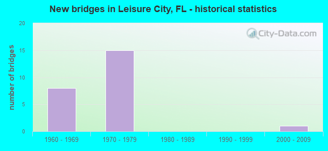
- New bridges - historical statistics
- 81960-1969
- 151970-1979
- 12000-2009

- Reconstructed bridges - Historical Statistics
- 11990-1999
- 42000-2009
- 12010-2019


- Bridge Condition - Deck
- 22.2%Very good
- 55.6%Good
- 11.1%Satisfactory
- 11.1%Poor

- Bridge Condition - Superstructure
- 22.2%Very good
- 55.6%Good
- 11.1%Satisfactory
- 11.1%Poor

- Bridge Condition - Substructure
- 11.1%Very good
- 72.2%Good
- 5.6%Satisfactory
- 11.1%Fair

- Bridge Condition - Channel
- 33.3%Very good
- 50.0%Good
- 8.3%Fair
- 8.3%Poor
Find on map >> Show street view
Structure Number: 87001, Location: 0.11M N OF SW 296 ST (Lat: 25.493333, Lng: -80.452611), Route carried "on" structure: US 1, Year Built: 1966, Year Reconstructed: 2012, Status: Open, Structure Length: 1.92m (6.30ft), Average Daily Traffic: 11,000 (year 2020), Truck Traffic: 6%, Average Future Daily Traffic: 19,085 (year 2042), Design Load: HL 93, Features Intersected: MOWRY CANAL C-103, Facility Carried by Structure: SR-5 SB (870228)
Minimum Vertical Clearance: 30+ m (98+ ft), Kilometerpoint: 7.158, Lanes on structure: 2, Owner: State Highway Agency, Approaching Roadway Width: 12.7m (41.7ft), Material/Design: Concrete, Design/Construction: Slab, Number Of Spans In Main Unit: 3, Length of Maximum Span: 6.4m (21.0ft), Curb or Sidewalk Widths: Left: 1.5m (4.9ft), Right: 0.0m, Curb-To-Curb Width: 12.7m (41.7ft), Out-to-Out Width: 15.4m (50.5ft)
Condition: Deck: Very good, Superstructure: Very good, Substructure: Good, Channel: Very good, Operating Rating: 42.5 metric tons, Method Used To Determine Operating Rating: Load and Resistance Factor (LRFR), Inventory Rating: 32.7 metric tons, Method Used To Determine Inventory Rating: Load and Resistance Factor (LRFR), Structural Evaluation: Better than present minimum criteria, Deck Geometry: Better than present minimum criteria, Waterway Adequacy: Equal to present desirable criteria, Approach Roadway Alignment: Equal to present desirable criteria, Length Of Structure Improvement: 1.92m (6.30ft), Designated Inspection Frequency: Every 24 months, Underwater Inspection Frequency: Every 24 months, Inspection Date: October 2021, Underwater Inspection Date: October 2021, Bridge Improvement Cost: $50,000, Total Project Cost: $50,000, Deck Structure Type: Concrete Cast-file-Place, Wearing Surface/Protective System: Wearing Surface: Bituminous
Find on map >> Show street view
Structure Number: 870017, Location: S OF SW 272 ST (Lat: 25.516136, Lng: -80.429956), Route carried "on" structure: US 1, Year Built: 1967, Year Reconstructed: 2011, Status: Open, Structure Length: 2.07m (6.79ft), Average Daily Traffic: 21,000 (year 2020), Truck Traffic: 4%, Average Future Daily Traffic: 36,435 (year 2042), Design Load: HL 93, Features Intersected: MOWRY CANAL C-103-N, Facility Carried by Structure: SR-5 SB (870240)
Minimum Vertical Clearance: 30+ m (98+ ft), Kilometerpoint: 10.557, Lanes on structure: 3, Owner: State Highway Agency, Approaching Roadway Width: 12.6m (41.3ft), Material/Design: Prestressed concrete, Design/Construction: Slab, Number Of Spans In Main Unit: 3, Length of Maximum Span: 8.5m (27.9ft), Curb or Sidewalk Widths: Left: 1.8m (5.9ft), Right: 0.0m, Curb-To-Curb Width: 12.6m (41.3ft), Out-to-Out Width: 15.4m (50.5ft)
Condition: Deck: Very good, Superstructure: Very good, Substructure: Very good, Channel: Very good, Operating Rating: 42.8 metric tons, Method Used To Determine Operating Rating: Load and Resistance Factor (LRFR), Inventory Rating: 34.9 metric tons, Method Used To Determine Inventory Rating: Load and Resistance Factor (LRFR), Structural Evaluation: Equal to present desirable criteria, Deck Geometry: Meets minimum limits, Waterway Adequacy: Equal to present desirable criteria, Approach Roadway Alignment: Equal to present desirable criteria, Length Of Structure Improvement: 0.63m (2.07ft), Designated Inspection Frequency: Every 24 months, Underwater Inspection Frequency: Every 24 months, Inspection Date: June 2021, Underwater Inspection Date: June 2021, Bridge Improvement Cost: $50,000, Total Project Cost: $50,000, Deck Structure Type: Concrete Precast Panels, Wearing Surface/Protective System: Wearing Surface: Bituminous
Find on map >> Show street view
Structure Number: 87017, Location: 7.5 MILES SOUTH OF US-1 (Lat: 25.499528, Lng: -80.417608), Route carried "on" structure: State highway 821, Year Built: 1973, Status: Open, Structure Length: 5.49m (18.01ft), Average Daily Traffic: 29,750 (year 2020), Truck Traffic: 8%, Average Future Daily Traffic: 51,616 (year 2042), Design Load: HS 20+Mod, Features Intersected: SW 288 ST BISCAYNE DR
Minimum Vertical Clearance: 30+ m (98+ ft), Kilometerpoint: 8.459, Lanes on structure: 2, Lanes under structure: 5, Base Highway Network: Yes, Toll: On toll road, Owner: State Toll Authority, Approaching Roadway Width: 17.7m (58.1ft), Material/Design: Prestressed concrete, Design/Construction: Stringer/Multi-beam, Number Of Spans In Main Unit: 3, Length of Maximum Span: 29.6m (97.1ft), Curb-To-Curb Width: 17.4m (57.1ft), Out-to-Out Width: 18.1m (59.4ft)
Condition: Deck: Good, Superstructure: Good, Substructure: Good, Operating Rating: 54.4 metric tons, Method Used To Determine Operating Rating: Load and Resistance Factor (LRFR), Inventory Rating: 24.9 metric tons, Method Used To Determine Inventory Rating: Load and Resistance Factor (LRFR), Structural Evaluation: Equal to present minimum criteria, Deck Geometry: Superior to present desirable criteria, Underclear: Somewhat better than minimum adequacy, Approach Roadway Alignment: Equal to present desirable criteria, Designated Inspection Frequency: Every 24 months, Inspection Date: Febuary 2020, Deck Structure Type: Concrete Cast-file-Place
Find on map >> Show street view
Structure Number: 870171, Location: 6.6 MILES SOUTH OF US-1 (Lat: 25.510775, Lng: -80.412522), Route carried "on" structure: State highway 821, Year Built: 1973, Status: Open, Structure Length: 10.50m (34.45ft), Average Daily Traffic: 34,100 (year 2020), Truck Traffic: 8%, Average Future Daily Traffic: 59,164 (year 2042), Design Load: HS 20+Mod, Features Intersected: SW 137 AVE
Minimum Vertical Clearance: 30+ m (98+ ft), Kilometerpoint: 9.828, Lanes on structure: 2, Lanes under structure: 6, Base Highway Network: Yes, Toll: On toll road, Owner: State Toll Authority, Approaching Roadway Width: 17.7m (58.1ft), Skew: 4 degrees, Material/Design: Prestressed concrete, Design/Construction: Stringer/Multi-beam, Number Of Spans In Main Unit: 5, Length of Maximum Span: 26.4m (86.6ft), Curb-To-Curb Width: 17.4m (57.1ft), Out-to-Out Width: 18.1m (59.4ft)
Condition: Deck: Good, Superstructure: Good, Substructure: Good, Operating Rating: 40.2 metric tons, Method Used To Determine Operating Rating: Load and Resistance Factor (LRFR), Inventory Rating: 36.9 metric tons, Method Used To Determine Inventory Rating: Load and Resistance Factor (LRFR), Structural Evaluation: Better than present minimum criteria, Deck Geometry: Superior to present desirable criteria, Underclear: Equal to present desirable criteria, Approach Roadway Alignment: Equal to present desirable criteria, Designated Inspection Frequency: Every 24 months, Inspection Date: Febuary 2020, Deck Structure Type: Concrete Cast-file-Place
Find on map >> Show street view
Structure Number: 870172, Location: 5.9 MILES SOUTH OF US-1 (Lat: 25.518172, Lng: -80.405006), Route carried "on" structure: State highway 821, Year Built: 1973, Status: Open, Structure Length: 6.40m (21.00ft), Average Daily Traffic: 41,350 (year 2020), Truck Traffic: 8%, Average Future Daily Traffic: 71,742 (year 2042), Design Load: HS 20+Mod, Features Intersected: SW 268 ST
Minimum Vertical Clearance: 30+ m (98+ ft), Kilometerpoint: 10.952, Lanes on structure: 2, Lanes under structure: 4, Base Highway Network: Yes, Toll: On toll road, Owner: State Toll Authority, Approaching Roadway Width: 12.8m (42.0ft), Skew: 4 degrees, Material/Design: Prestressed concrete, Design/Construction: Stringer/Multi-beam, Number Of Spans In Main Unit: 3, Length of Maximum Span: 31.1m (102.0ft), Curb-To-Curb Width: 17.4m (57.1ft), Out-to-Out Width: 18.0m (59.1ft)
Condition: Deck: Good, Superstructure: Good, Substructure: Good, Operating Rating: 41.5 metric tons, Method Used To Determine Operating Rating: Load and Resistance Factor (LRFR), Inventory Rating: 32.0 metric tons, Method Used To Determine Inventory Rating: Load and Resistance Factor (LRFR), Structural Evaluation: Better than present minimum criteria, Deck Geometry: Superior to present desirable criteria, Underclear: Somewhat better than minimum adequacy, Approach Roadway Alignment: Equal to present minimum criteria, Designated Inspection Frequency: Every 24 months, Inspection Date: Febuary 2020, Deck Structure Type: Concrete Cast-file-Place
Find on map >> Show street view
Structure Number: 87018, Location: 7.6 MILES SOUTH OF US-1 (Lat: 25.494200, Lng: -80.418517), Route carried "on" structure: State highway 821, Year Built: 1973, Status: Open, Structure Length: 4.33m (14.21ft), Average Daily Traffic: 29,750 (year 2020), Truck Traffic: 8%, Average Future Daily Traffic: 51,616 (year 2042), Design Load: HS 20+Mod, Features Intersected: CANAL C-103-N
Minimum Vertical Clearance: 30+ m (98+ ft), Kilometerpoint: 7.849, Lanes on structure: 2, Base Highway Network: Yes, Toll: On toll road, Owner: State Toll Authority, Approaching Roadway Width: 19.0m (62.3ft), Skew: 1 degrees, Material/Design: Prestressed concrete, Design/Construction: Stringer/Multi-beam, Number Of Spans In Main Unit: 3, Length of Maximum Span: 16.9m (55.4ft), Curb-To-Curb Width: 17.4m (57.1ft), Out-to-Out Width: 17.8m (58.4ft)
Condition: Deck: Good, Superstructure: Good, Substructure: Good, Channel: Good, Operating Rating: 45.0 metric tons, Method Used To Determine Operating Rating: Load Factor (LF), Inventory Rating: 26.7 metric tons, Method Used To Determine Inventory Rating: Load Factor (LF), Structural Evaluation: Equal to present minimum criteria, Deck Geometry: Superior to present desirable criteria, Waterway Adequacy: Equal to present desirable criteria, Approach Roadway Alignment: Equal to present desirable criteria, Designated Inspection Frequency: Every 24 months, Underwater Inspection Frequency: Every 24 months, Inspection Date: Febuary 2020, Underwater Inspection Date: Febuary 2020, Deck Structure Type: Concrete Cast-file-Place
Find on map >> Show street view
Structure Number: 870228, Location: 0.11M N OF SW 296 ST (Lat: 25.493222, Lng: -80.452500), Route carried "on" structure: US 1, Year Built: 1966, Year Reconstructed: 2011, Status: Open, Structure Length: 1.92m (6.30ft), Average Daily Traffic: 11,000 (year 2020), Truck Traffic: 6%, Average Future Daily Traffic: 19,085 (year 2042), Design Load: HL 93, Features Intersected: MOWRY CANAL C-103
Minimum Vertical Clearance: 30+ m (98+ ft), Kilometerpoint: 7.158, Lanes on structure: 2, Owner: State Highway Agency, Approaching Roadway Width: 12.7m (41.7ft), Material/Design: Concrete, Design/Construction: Slab, Number Of Spans In Main Unit: 3, Length of Maximum Span: 6.4m (21.0ft), Curb or Sidewalk Widths: Left: 0.0m, Right: 1.5m (4.9ft), Curb-To-Curb Width: 12.7m (41.7ft), Out-to-Out Width: 15.4m (50.5ft)
Condition: Deck: Very good, Superstructure: Very good, Substructure: Good, Channel: Very good, Operating Rating: 42.5 metric tons, Method Used To Determine Operating Rating: Load and Resistance Factor (LRFR), Inventory Rating: 32.7 metric tons, Method Used To Determine Inventory Rating: Load and Resistance Factor (LRFR), Structural Evaluation: Better than present minimum criteria, Deck Geometry: Better than present minimum criteria, Waterway Adequacy: Equal to present desirable criteria, Approach Roadway Alignment: Equal to present desirable criteria, Designated Inspection Frequency: Every 24 months, Underwater Inspection Frequency: Every 24 months, Inspection Date: October 2021, Underwater Inspection Date: October 2021, Deck Structure Type: Concrete Cast-file-Place, Wearing Surface/Protective System: Wearing Surface: Bituminous
Find on map >> Show street view
Structure Number: 87024, Location: S OF SW 272 ST (Lat: 25.516033, Lng: -80.429814), Route carried "on" structure: US 1, Year Built: 1967, Year Reconstructed: 2011, Status: Open, Structure Length: 2.07m (6.79ft), Average Daily Traffic: 21,000 (year 2020), Truck Traffic: 4%, Average Future Daily Traffic: 36,435 (year 2042), Design Load: HL 93, Features Intersected: MOWRY CANAL C-103-N
Minimum Vertical Clearance: 30+ m (98+ ft), Kilometerpoint: 10.557, Lanes on structure: 3, Owner: State Highway Agency, Approaching Roadway Width: 12.6m (41.3ft), Material/Design: Prestressed concrete, Design/Construction: Slab, Number Of Spans In Main Unit: 3, Length of Maximum Span: 8.5m (27.9ft), Curb or Sidewalk Widths: Left: 0.0m, Right: 1.5m (4.9ft), Curb-To-Curb Width: 12.6m (41.3ft), Out-to-Out Width: 15.4m (50.5ft)
Condition: Deck: Very good, Superstructure: Very good, Substructure: Very good, Channel: Very good, Operating Rating: 42.8 metric tons, Method Used To Determine Operating Rating: Load and Resistance Factor (LRFR), Inventory Rating: 34.9 metric tons, Method Used To Determine Inventory Rating: Load and Resistance Factor (LRFR), Structural Evaluation: Equal to present desirable criteria, Deck Geometry: Meets minimum limits, Waterway Adequacy: Equal to present desirable criteria, Approach Roadway Alignment: Better than present minimum criteria, Designated Inspection Frequency: Every 24 months, Underwater Inspection Frequency: Every 24 months, Inspection Date: June 2021, Underwater Inspection Date: June 2021, Deck Structure Type: Concrete Precast Panels, Wearing Surface/Protective System: Wearing Surface: Bituminous
Find on map >> Show street view
Structure Number: 870381, Location: 7.5 MILES SOUTH OF US-1 (Lat: 25.499528, Lng: -80.417275), Route carried "on" structure: State highway 821, Year Built: 1973, Year Reconstructed: 1996, Status: Open, Structure Length: 5.49m (18.01ft), Average Daily Traffic: 29,750 (year 2020), Truck Traffic: 8%, Average Future Daily Traffic: 51,616 (year 2042), Design Load: HS 20+Mod, Features Intersected: SW 288 ST BISCAYNE DR
Minimum Vertical Clearance: 30+ m (98+ ft), Kilometerpoint: 8.462, Lanes on structure: 4, Lanes under structure: 5, Base Highway Network: Yes, Toll: On toll road, Owner: State Toll Authority, Approaching Roadway Width: 20.0m (65.6ft), Material/Design: Prestressed concrete, Design/Construction: Stringer/Multi-beam, Number Of Spans In Main Unit: 3, Length of Maximum Span: 29.6m (97.1ft), Curb-To-Curb Width: 19.2m (63.0ft), Out-to-Out Width: 20.5m (67.3ft)
Condition: Deck: Good, Superstructure: Good, Substructure: Good, Operating Rating: 61.7 metric tons, Method Used To Determine Operating Rating: Load and Resistance Factor (LRFR), Inventory Rating: 44.7 metric tons, Method Used To Determine Inventory Rating: Load and Resistance Factor (LRFR), Structural Evaluation: Better than present minimum criteria, Deck Geometry: Somewhat better than minimum adequacy, Underclear: Equal to present minimum criteria, Approach Roadway Alignment: Equal to present desirable criteria, Designated Inspection Frequency: Every 24 months, Inspection Date: Febuary 2020, Deck Structure Type: Concrete Cast-file-Place
Find on map >> Show street view
Structure Number: 870382, Location: 6.6 MILES SOUTH OF US-1 (Lat: 25.510378, Lng: -80.412517), Route carried "on" structure: State highway 821, Year Built: 1973, Year Reconstructed: 2019, Status: Open, Structure Length: 12.77m (41.90ft), Average Daily Traffic: 34,100 (year 2020), Truck Traffic: 8%, Average Future Daily Traffic: 59,164 (year 2042), Design Load: HS 20+Mod, Features Intersected: SW 137 AVE
Minimum Vertical Clearance: 30+ m (98+ ft), Kilometerpoint: 9.786, Lanes on structure: 4, Lanes under structure: 6, Base Highway Network: Yes, Toll: On toll road, Owner: State Toll Authority, Approaching Roadway Width: 21.8m (71.5ft), Skew: 4 degrees, Material/Design: Prestressed concrete, Design/Construction: Stringer/Multi-beam, Number Of Spans In Main Unit: 6, Length of Maximum Span: 26.4m (86.6ft), Curb-To-Curb Width: 21.8m (71.5ft), Out-to-Out Width: 24.1m (79.1ft)
Condition: Deck: Good, Superstructure: Good, Substructure: Good, Operating Rating: 43.5 metric tons, Method Used To Determine Operating Rating: Load and Resistance Factor (LRFR), Inventory Rating: 33.3 metric tons, Method Used To Determine Inventory Rating: Load and Resistance Factor (LRFR), Structural Evaluation: Better than present minimum criteria, Deck Geometry: Better than present minimum criteria, Underclear: Superior to present desirable criteria, Approach Roadway Alignment: Equal to present desirable criteria, Designated Inspection Frequency: Every 24 months, Inspection Date: Febuary 2020, Deck Structure Type: Concrete Cast-file-Place
Find on map >> Show street view
Structure Number: 870383, Location: 5.9 MILES SOUTH OF US-1 (Lat: 25.518164, Lng: -80.404572), Route carried "on" structure: State highway 821, Year Built: 1973, Status: Open, Structure Length: 6.40m (21.00ft), Average Daily Traffic: 41,350 (year 2020), Truck Traffic: 8%, Average Future Daily Traffic: 71,742 (year 2042), Design Load: HS 20+Mod, Features Intersected: SW 268 ST
Minimum Vertical Clearance: 30+ m (98+ ft), Kilometerpoint: 10.992, Lanes on structure: 2, Lanes under structure: 4, Base Highway Network: Yes, Toll: On toll road, Owner: State Toll Authority, Approaching Roadway Width: 12.6m (41.3ft), Skew: 4 degrees, Material/Design: Prestressed concrete, Design/Construction: Stringer/Multi-beam, Number Of Spans In Main Unit: 3, Length of Maximum Span: 31.1m (102.0ft), Curb-To-Curb Width: 17.4m (57.1ft), Out-to-Out Width: 18.0m (59.1ft)
Condition: Deck: Good, Superstructure: Good, Substructure: Good, Operating Rating: 41.5 metric tons, Method Used To Determine Operating Rating: Load and Resistance Factor (LRFR), Inventory Rating: 32.0 metric tons, Method Used To Determine Inventory Rating: Load and Resistance Factor (LRFR), Structural Evaluation: Better than present minimum criteria, Deck Geometry: Superior to present desirable criteria, Underclear: Somewhat better than minimum adequacy, Approach Roadway Alignment: Equal to present minimum criteria, Designated Inspection Frequency: Every 24 months, Inspection Date: Febuary 2020, Deck Structure Type: Concrete Cast-file-Place
Find on map >> Show street view
Structure Number: 870391, Location: 7.6 MILES SOUTH OF US-1 (Lat: 25.494056, Lng: -80.418242), Route carried "on" structure: State highway 821, Year Built: 1973, Status: Open, Structure Length: 4.33m (14.21ft), Average Daily Traffic: 29,750 (year 2020), Truck Traffic: 8%, Average Future Daily Traffic: 51,616 (year 2042), Design Load: HS 20+Mod, Features Intersected: CANAL C-103-N
Minimum Vertical Clearance: 30+ m (98+ ft), Kilometerpoint: 7.842, Lanes on structure: 3, Base Highway Network: Yes, Toll: On toll road, Owner: State Toll Authority, Approaching Roadway Width: 20.1m (65.9ft), Skew: 1 degrees, Material/Design: Prestressed concrete, Design/Construction: Stringer/Multi-beam, Number Of Spans In Main Unit: 3, Length of Maximum Span: 16.9m (55.4ft), Curb-To-Curb Width: 19.8m (65.0ft), Out-to-Out Width: 20.5m (67.3ft)
Condition: Deck: Good, Superstructure: Good, Substructure: Good, Channel: Good, Operating Rating: 40.9 metric tons, Method Used To Determine Operating Rating: Load Factor (LF), Inventory Rating: 24.8 metric tons, Method Used To Determine Inventory Rating: Load Factor (LF), Structural Evaluation: Equal to present minimum criteria, Deck Geometry: Superior to present desirable criteria, Waterway Adequacy: Equal to present desirable criteria, Approach Roadway Alignment: Equal to present desirable criteria, Designated Inspection Frequency: Every 24 months, Underwater Inspection Frequency: Every 24 months, Inspection Date: Febuary 2020, Underwater Inspection Date: Febuary 2020, Deck Structure Type: Concrete Cast-file-Place
Find on map >> Show street view
Structure Number: 87098, Location: 125Ft. N of SW 232nd St. (Lat: 25.551678, Lng: -80.396558), Route carried "on" structure: Other road , Year Built: 2005, Status: Open, Structure Length: 1.81m (5.94ft), Design Load: HS 20, Features Intersected: Canal C-102-N, Facility Carried by Structure: Busway Extension
Minimum Vertical Clearance: 30+ m (98+ ft), Kilometerpoint: 14.775, Lanes on structure: 2, Owner: County Highway Agency, Approaching Roadway Width: 8.4m (27.6ft), Material/Design: Prestressed concrete, Design/Construction: Tee Beam, Number Of Spans In Main Unit: 3, Length of Maximum Span: 8.6m (28.2ft), Curb or Sidewalk Widths: Left: 3.1m (10.2ft), Right: 0.0m, Curb-To-Curb Width: 13.2m (43.3ft), Out-to-Out Width: 17.7m (58.1ft)
Condition: Deck: Good, Superstructure: Good, Substructure: Good, Channel: Good, Inventory Rating: 84.5 metric tons, Method Used To Determine Inventory Rating: Load Factor (LF), Structural Evaluation: Better than present minimum criteria, Deck Geometry: Superior to present desirable criteria, Waterway Adequacy: Equal to present desirable criteria, Approach Roadway Alignment: Equal to present desirable criteria, Designated Inspection Frequency: Every 24 months, Underwater Inspection Frequency: Every 24 months, Inspection Date: December 2021, Underwater Inspection Date: December 2021, Deck Structure Type: Concrete Cast-file-Place, Wearing Surface/Protective System: Wearing Surface: Integral Concrete
Find on map >> Show street view
Structure Number: 874093, Location: 300Ft. W of SW 167th Ave. (Lat: 25.499225, Lng: -80.462100), Route carried "on" structure: Alternate County highway , Year Built: 1966, Status: Open, Structure Length: 1.52m (4.99ft), Average Daily Traffic: 4,884 (year 2000), Truck Traffic: 2%, Average Future Daily Traffic: 8,474 (year 2033), Design Load: HL 93, Features Intersected: Canal C-103, Facility Carried by Structure: SW 288th Street
Minimum Vertical Clearance: 30+ m (98+ ft), Kilometerpoint: 1.559, Lanes on structure: 2, Owner: County Highway Agency, Approaching Roadway Width: 8.5m (27.9ft), Material/Design: Prestressed concrete, Design/Construction: Slab, Number Of Spans In Main Unit: 1, Length of Maximum Span: 15.2m (49.9ft), Curb or Sidewalk Widths: Left: 1.2m (3.9ft), Right: 1.2m (3.9ft), Curb-To-Curb Width: 8.5m (27.9ft), Out-to-Out Width: 11.6m (38.1ft)
Condition: Deck: Poor, Superstructure: Poor, Substructure: Good, Channel: Good, Operating Rating: 42.0 metric tons, Method Used To Determine Operating Rating: Load and Resistance Factor (LRFR), Inventory Rating: 31.3 metric tons, Method Used To Determine Inventory Rating: Load and Resistance Factor (LRFR), Structural Evaluation: Meets minimum limits, Deck Geometry: Meets minimum limits, Waterway Adequacy: Better than present minimum criteria, Approach Roadway Alignment: Equal to present desirable criteria, Designated Inspection Frequency: Every 24 months, Other Special Inspection Frequency: Every 12 months, Inspection Date: May 2021, Other Special Inspection Date: May 2021, Deck Structure Type: Concrete Precast Panels, Wearing Surface/Protective System: Wearing Surface: Bituminous
Find on map >> Show street view
Structure Number: 874104, Location: 900Ft N. of SW 296th St (Lat: 25.493861, Lng: -80.453294), Route carried "on" structure: County highway , Year Built: 1967, Status: Open, Structure Length: 1.53m (5.02ft), Average Daily Traffic: 3,171 (year 2015), Truck Traffic: 5%, Average Future Daily Traffic: 5,166 (year 2038), Design Load: HL 93, Features Intersected: Canal C-103, Facility Carried by Structure: Old Dixie Highway
Minimum Vertical Clearance: 30+ m (98+ ft), Kilometerpoint: 2.454, Lanes on structure: 2, Owner: County Highway Agency, Approaching Roadway Width: 7.3m (24.0ft), Material/Design: Prestressed concrete, Design/Construction: Slab, Number Of Spans In Main Unit: 1, Length of Maximum Span: 15.3m (50.2ft), Curb or Sidewalk Widths: Left: 1.2m (3.9ft), Right: 1.2m (3.9ft), Curb-To-Curb Width: 8.6m (28.2ft), Out-to-Out Width: 11.6m (38.1ft)
Condition: Deck: Good, Superstructure: Good, Substructure: Fair, Channel: Fair, Operating Rating: 42.0 metric tons, Method Used To Determine Operating Rating: Load and Resistance Factor (LRFR), Inventory Rating: 31.3 metric tons, Method Used To Determine Inventory Rating: Load and Resistance Factor (LRFR), Structural Evaluation: Somewhat better than minimum adequacy, Deck Geometry: Meets minimum limits, Waterway Adequacy: Equal to present desirable criteria, Approach Roadway Alignment: Equal to present desirable criteria, Designated Inspection Frequency: Every 24 months, Inspection Date: October 2021, Deck Structure Type: Concrete Precast Panels, Wearing Surface/Protective System: Wearing Surface: Bituminous
Find on map >> Show street view
Structure Number: 874105, Location: 600Ft. E of US-1 (Lat: 25.492000, Lng: -80.452000), Route carried "on" structure: County highway , Year Built: 1966, Status: Open, Structure Length: 1.52m (4.99ft), Average Daily Traffic: 6,320 (year 2021), Truck Traffic: 5%, Average Future Daily Traffic: 10,624 (year 2041), Design Load: HL 93, Features Intersected: Canal C-103 Mowry, Facility Carried by Structure: SW 296th Street
Minimum Vertical Clearance: 30+ m (98+ ft), Kilometerpoint: 0.190, Lanes on structure: 2, Owner: County Highway Agency, Approaching Roadway Width: 7.6m (24.9ft), Material/Design: Prestressed concrete, Design/Construction: Slab, Number Of Spans In Main Unit: 1, Length of Maximum Span: 15.2m (49.9ft), Curb or Sidewalk Widths: Left: 1.2m (3.9ft), Right: 1.2m (3.9ft), Curb-To-Curb Width: 8.5m (27.9ft), Out-to-Out Width: 11.6m (38.1ft)
Condition: Deck: Poor, Superstructure: Poor, Substructure: Fair, Channel: Poor, Operating Rating: 42.0 metric tons, Method Used To Determine Operating Rating: Load and Resistance Factor (LRFR), Inventory Rating: 31.3 metric tons, Method Used To Determine Inventory Rating: Load and Resistance Factor (LRFR), Structural Evaluation: Meets minimum limits, Deck Geometry: High priority of replacement, Waterway Adequacy: Equal to present minimum criteria, Approach Roadway Alignment: Equal to present desirable criteria, Designated Inspection Frequency: Every 24 months, Other Special Inspection Frequency: Every 12 months, Inspection Date: November 2021, Other Special Inspection Date: November 2021, Deck Structure Type: Concrete Precast Panels, Wearing Surface/Protective System: Wearing Surface: Bituminous
Find on map >> Show street view
Structure Number: 874212, Location: 400Ft. S. of SW 288th St. (Lat: 25.498147, Lng: -80.461183), Route carried "on" structure: County highway , Year Built: 1967, Status: Open, Structure Length: 1.52m (4.99ft), Average Daily Traffic: 1,160 (year 2015), Truck Traffic: 3%, Average Future Daily Traffic: 2,184 (year 2038), Design Load: HL 93, Features Intersected: Canal C-103, Facility Carried by Structure: SW 167th Avenue
Minimum Vertical Clearance: 30+ m (98+ ft), Kilometerpoint: 1.370, Lanes on structure: 2, Owner: County Highway Agency, Approaching Roadway Width: 7.3m (24.0ft), Material/Design: Prestressed concrete, Design/Construction: Slab, Number Of Spans In Main Unit: 1, Length of Maximum Span: 15.2m (49.9ft), Curb or Sidewalk Widths: Left: 1.2m (3.9ft), Right: 1.2m (3.9ft), Curb-To-Curb Width: 8.6m (28.2ft), Out-to-Out Width: 11.6m (38.1ft)
Condition: Deck: Satisfactory, Superstructure: Satisfactory, Substructure: Good, Channel: Good, Operating Rating: 42.0 metric tons, Method Used To Determine Operating Rating: Load and Resistance Factor (LRFR), Inventory Rating: 31.3 metric tons, Method Used To Determine Inventory Rating: Load and Resistance Factor (LRFR), Structural Evaluation: Equal to present minimum criteria, Deck Geometry: Somewhat better than minimum adequacy, Waterway Adequacy: Better than present minimum criteria, Approach Roadway Alignment: Equal to present desirable criteria, Designated Inspection Frequency: Every 24 months, Inspection Date: October 2021, Deck Structure Type: Concrete Precast Panels, Wearing Surface/Protective System: Wearing Surface: Bituminous
Find on map >> Show street view
Structure Number: 874755, Location: 1.1 Miles E of US 1 (Lat: 25.507194, Lng: -80.420806), Route carried "on" structure: County highway , Year Built: 1972, Status: Open, Structure Length: 2.03m (6.66ft), Average Daily Traffic: 2,289 (year 2014), Truck Traffic: 1%, Average Future Daily Traffic: 3,893 (year 2036), Design Load: HS 20, Features Intersected: Canal C-103-N, Facility Carried by Structure: SW 280th Street
Minimum Vertical Clearance: 30+ m (98+ ft), Kilometerpoint: 0.063, Lanes on structure: 2, Owner: County Highway Agency, Approaching Roadway Width: 6.4m (21.0ft), Skew: 1 degrees, Material/Design: Prestressed concrete, Design/Construction: Slab, Number Of Spans In Main Unit: 3, Length of Maximum Span: 9.4m (30.8ft), Curb or Sidewalk Widths: Left: 2.1m (6.9ft), Right: 0.5m (1.6ft), Curb-To-Curb Width: 8.5m (27.9ft), Out-to-Out Width: 11.8m (38.7ft)
Condition: Deck: Satisfactory, Superstructure: Satisfactory, Substructure: Satisfactory, Channel: Good, Operating Rating: 47.2 metric tons, Method Used To Determine Operating Rating: Load Factor (LF), Inventory Rating: 28.3 metric tons, Method Used To Determine Inventory Rating: Load Factor (LF), Structural Evaluation: Equal to present minimum criteria, Deck Geometry: Meets minimum limits, Waterway Adequacy: Equal to present minimum criteria, Approach Roadway Alignment: Equal to present desirable criteria, Designated Inspection Frequency: Every 24 months, Underwater Inspection Frequency: Every 24 months, Inspection Date: May 2020, Underwater Inspection Date: May 2020, Deck Structure Type: Concrete Precast Panels, Wearing Surface/Protective System: Wearing Surface: Bituminous
Find on map >> Show street view
Structure Number: 87017, Location: 7.5 MILES SOUTH OF US-1 (Lat: 25.499528, Lng: -80.417608), Route carried "under" structure: City street , Year Built: 1973, Structure Length: 0. m, Average Daily Traffic: 29,750 (year 2020), Truck Traffic: 8%, Features Intersected: SW 288 ST BISCAYNE DR, Facility Carried by Structure: SR821 SB HEFT 5.21
Minimum Vertical Clearance: 5.12m (16.80ft), Kilometerpoint: 8.459, Lanes on structure: 2, Lanes under structure: 5, Material/Design: Prestressed concrete, Design/Construction: Stringer/Multi-beam, Length of Maximum Span: 29.6m (97.1ft)
Find on map >> Show street view
Structure Number: 870171, Location: 6.6 MILES SOUTH OF US-1 (Lat: 25.510775, Lng: -80.412522), Route carried "under" structure: City street , Year Built: 1973, Structure Length: 0. m, Average Daily Traffic: 34,100 (year 2020), Truck Traffic: 8%, Features Intersected: SW 137 AVE, Facility Carried by Structure: SR821 SB HEFT 6.06
Minimum Vertical Clearance: 6.55m (21.49ft), Kilometerpoint: 9.828, Lanes on structure: 2, Lanes under structure: 4, Material/Design: Prestressed concrete, Design/Construction: Stringer/Multi-beam, Length of Maximum Span: 26.4m (86.6ft)
Find on map >> Show street view
Structure Number: 870172, Location: 5.9 MILES SOUTH OF US-1 (Lat: 25.518172, Lng: -80.405006), Route carried "under" structure: City street , Year Built: 1973, Structure Length: 0. m, Average Daily Traffic: 41,350 (year 2020), Truck Traffic: 8%, Features Intersected: SW 268 ST, Facility Carried by Structure: SR821 SB HEFT 6.76
Minimum Vertical Clearance: 5.00m (16.40ft), Kilometerpoint: 10.952, Lanes on structure: 2, Lanes under structure: 4, Material/Design: Prestressed concrete, Design/Construction: Stringer/Multi-beam, Length of Maximum Span: 31.1m (102.0ft)
Find on map >> Show street view
Structure Number: 870381, Location: 7.5 MILES SOUTH OF US-1 (Lat: 25.499528, Lng: -80.417275), Route carried "under" structure: City street , Year Built: 1973, Structure Length: 0. m, Average Daily Traffic: 29,750 (year 2020), Truck Traffic: 8%, Features Intersected: SW 288 ST BISCAYNE DR, Facility Carried by Structure: SR821 NB HEFT 5.2
Minimum Vertical Clearance: 5.12m (16.80ft), Kilometerpoint: 8.462, Lanes on structure: 4, Lanes under structure: 5, Material/Design: Prestressed concrete, Design/Construction: Stringer/Multi-beam, Length of Maximum Span: 29.6m (97.1ft)
Find on map >> Show street view
Structure Number: 870382, Location: 6.6 MILES SOUTH OF US-1 (Lat: 25.510378, Lng: -80.412517), Route carried "under" structure: City street , Year Built: 1973, Structure Length: 0. m, Average Daily Traffic: 34,100 (year 2020), Truck Traffic: 8%, Features Intersected: SW 137 AVE, Facility Carried by Structure: SR821 NB HEFT 6.04
Minimum Vertical Clearance: 6.46m (21.19ft), Kilometerpoint: 9.786, Lanes on structure: 4, Lanes under structure: 4, Material/Design: Prestressed concrete, Design/Construction: Stringer/Multi-beam, Length of Maximum Span: 26.4m (86.6ft)
Find on map >> Show street view
Structure Number: 870383, Location: 5.9 MILES SOUTH OF US-1 (Lat: 25.518164, Lng: -80.404572), Route carried "under" structure: City street , Year Built: 1973, Structure Length: 0. m, Average Daily Traffic: 41,350 (year 2020), Truck Traffic: 8%, Features Intersected: SW 268 ST, Facility Carried by Structure: SR821 NB HEFT 6.78
Minimum Vertical Clearance: 5.18m (16.99ft), Kilometerpoint: 10.992, Lanes on structure: 2, Lanes under structure: 4, Material/Design: Prestressed concrete, Design/Construction: Stringer/Multi-beam, Length of Maximum Span: 31.1m (102.0ft)