Bridge Statistics for Lewis, New York (NY)
Condition, Traffic, Stress, Structural Evaluation, Project Costs
- National Bridge Inventory (NBI) Statistics
- 30Number of bridges
- 374ft / 114mTotal length
- $44,030,000Total costs
- 48,374Total average daily traffic
- 8,116Total average daily truck traffic
- National Bridge Inventory (NBI) Registered Bridges for Lewis
- No street view available for this location
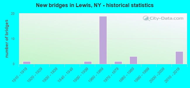
- New bridges - historical statistics
- 11910-1919
- 11950-1959
- 191960-1969
- 11970-1979
- 31980-1989
- 52010-2019


- Bridge Condition - Deck
- 4.8%Excellent
- 9.5%Very good
- 19.0%Good
- 47.6%Satisfactory
- 14.3%Fair
- 4.8%Poor

- Bridge Condition - Superstructure
- 14.3%Excellent
- 9.5%Very good
- 47.6%Good
- 19.0%Satisfactory
- 9.5%Fair

- Bridge Condition - Substructure
- 14.3%Excellent
- 19.0%Very good
- 42.9%Good
- 14.3%Satisfactory
- 9.5%Fair

- Bridge Condition - Channel
- 5.0%Excellent
- 30.0%Very good
- 20.0%Good
- 20.0%Satisfactory
- 15.0%Fair
- 10.0%Poor

- Bridge Condition - Culverts
- 33.3%Satisfactory
- 66.7%Fair
Find on map >> Show street view
Structure Number: 10059, Location: RT 9 5.5 MI N OF LEWIS (Lat: 44.351961, Lng: -73.543572), Route carried "on" structure: US 9, Year Built: 1964, Status: Open, Structure Length: 5.85m (19.19ft), Average Daily Traffic: 759 (year 2017), Truck Traffic: 18%, Average Future Daily Traffic: 791 (year 2040), Design Load: HS 20+Mod, Features Intersected: N BR BOUQUET RIV
Minimum Vertical Clearance: 30+ m (98+ ft), Kilometerpoint: 74.143, Lanes on structure: 2, Base Highway Network: Yes, Owner: State Highway Agency, Approaching Roadway Width: 10.4m (34.1ft), Skew: 5 degrees, Material/Design: Steel, Design/Construction: Stringer/Multi-beam, Number Of Spans In Main Unit: 2, Length of Maximum Span: 27.4m (89.9ft), Curb or Sidewalk Widths: Left: 0.6m (2.0ft), Right: 0.6m (2.0ft), Curb-To-Curb Width: 8.5m (27.9ft), Out-to-Out Width: 10.1m (33.1ft)
Condition: Deck: Satisfactory, Superstructure: Good, Substructure: Good, Channel: Good, Operating Rating: 70.8 metric tons, Method Used To Determine Operating Rating: Load Factor (LF), Inventory Rating: 41.7 metric tons, Method Used To Determine Inventory Rating: Load Factor (LF), Structural Evaluation: Better than present minimum criteria, Deck Geometry: Somewhat better than minimum adequacy, Waterway Adequacy: Superior to present desirable criteria, Approach Roadway Alignment: Equal to present desirable criteria, Length Of Structure Improvement: 5.85m (19.19ft), Designated Inspection Frequency: Every 24 months, Inspection Date: October 2021, Bridge Improvement Cost: $1,443,000, Roadway Improvement Cost: $845,000, Total Project Cost: $2,289,000 ( Estimate for 2021), Deck Structure Type: Concrete Cast-file-Place, Wearing Surface/Protective System: Wearing Surface: Bituminous
Find on map >> Show street view
Structure Number: 1033761, Location: RT I87 2.6 MI N EXIT 31 (Lat: 44.245844, Lng: -73.501869), Route carried "on" structure: Interstate 87, Year Built: 1965, Status: Open, Structure Length: 3.87m (12.70ft), Average Daily Traffic: 4,238 (year 2005), Truck Traffic: 30%, Design Load: HS 20+Mod, Features Intersected: BLACK RIVER
Minimum Vertical Clearance: 30+ m (98+ ft), Kilometerpoint: 62.606, Lanes on structure: 2, Base Highway Network: Yes, Owner: State Highway Agency, Approaching Roadway Width: 12.2m (40.0ft), Skew: 4 degrees, Material/Design: Steel, Design/Construction: Stringer/Multi-beam, Number Of Spans In Main Unit: 1, Length of Maximum Span: 38.4m (126.0ft), Curb or Sidewalk Widths: Left: 0.5m (1.6ft), Right: 0.5m (1.6ft), Curb-To-Curb Width: 11.9m (39.0ft), Out-to-Out Width: 12.8m (42.0ft)
Condition: Deck: Satisfactory, Superstructure: Good, Substructure: Good, Channel: Good, Operating Rating: 88.0 metric tons, Method Used To Determine Operating Rating: Load Factor (LF), Inventory Rating: 52.6 metric tons, Method Used To Determine Inventory Rating: Load Factor (LF), Structural Evaluation: Better than present minimum criteria, Deck Geometry: Equal to present minimum criteria, Waterway Adequacy: Superior to present desirable criteria, Approach Roadway Alignment: Equal to present desirable criteria, Length Of Structure Improvement: 3.87m (12.70ft), Designated Inspection Frequency: Every 24 months, Inspection Date: April 2021, Bridge Improvement Cost: $1,330,000, Roadway Improvement Cost: $779,000, Total Project Cost: $2,108,000 ( Estimate for 2021), Deck Structure Type: Concrete Cast-file-Place, Wearing Surface/Protective System: Wearing Surface: Monolithic Concrete
Find on map >> Show street view
Structure Number: 1033762, Location: RT I87 2.6 MI N EXIT 31 (Lat: 44.246053, Lng: -73.501583), Route carried "on" structure: Interstate 87, Year Built: 1965, Status: Open, Structure Length: 4.05m (13.29ft), Average Daily Traffic: 2,846 (year 2018), Truck Traffic: 32%, Average Future Daily Traffic: 3,389 (year 2040), Design Load: HS 20+Mod, Features Intersected: BLACK RIVER
Minimum Vertical Clearance: 30+ m (98+ ft), Kilometerpoint: 62.606, Lanes on structure: 2, Base Highway Network: Yes, Owner: State Highway Agency, Approaching Roadway Width: 12.2m (40.0ft), Skew: 4 degrees, Material/Design: Steel, Design/Construction: Stringer/Multi-beam, Number Of Spans In Main Unit: 1, Length of Maximum Span: 36.5m (119.8ft), Curb or Sidewalk Widths: Left: 0.5m (1.6ft), Right: 0.5m (1.6ft), Curb-To-Curb Width: 11.9m (39.0ft), Out-to-Out Width: 12.7m (41.7ft)
Condition: Deck: Fair, Superstructure: Good, Substructure: Good, Channel: Good, Operating Rating: 88.0 metric tons, Method Used To Determine Operating Rating: Load Factor (LF), Inventory Rating: 52.6 metric tons, Method Used To Determine Inventory Rating: Load Factor (LF), Structural Evaluation: Better than present minimum criteria, Deck Geometry: Equal to present minimum criteria, Waterway Adequacy: Superior to present desirable criteria, Approach Roadway Alignment: Equal to present desirable criteria, Length Of Structure Improvement: 4.05m (13.29ft), Designated Inspection Frequency: Every 24 months, Inspection Date: April 2021, Bridge Improvement Cost: $1,391,000, Roadway Improvement Cost: $815,000, Total Project Cost: $2,206,000 ( Estimate for 2021), Deck Structure Type: Concrete Cast-file-Place, Wearing Surface/Protective System: Wearing Surface: Monolithic Concrete
Find on map >> Show street view
Structure Number: 1033771, Location: RT I87 2.8 MI N EXIT 31 (Lat: 44.249331, Lng: -73.502164), Route carried "on" structure: Interstate 87, Year Built: 1965, Status: Open, Structure Length: 11.25m (36.91ft), Average Daily Traffic: 4,238 (year 2005), Truck Traffic: 30%, Design Load: HS 20+Mod, Features Intersected: CR 10, LEWIS-WADHAMS RD,
Minimum Vertical Clearance: 30+ m (98+ ft), Kilometerpoint: 62.896, Lanes on structure: 2, Lanes under structure: 2, Base Highway Network: Yes, Owner: State Highway Agency, Approaching Roadway Width: 8.5m (27.9ft), Skew: 2 degrees, Material/Design: Steel, Design/Construction: Stringer/Multi-beam, Number Of Spans In Main Unit: 3, Length of Maximum Span: 39.0m (128.0ft), Curb-To-Curb Width: 8.6m (28.2ft), Out-to-Out Width: 10.0m (32.8ft)
Condition: Deck: Satisfactory, Superstructure: Good, Substructure: Satisfactory, Channel: Satisfactory, Operating Rating: 68.0 metric tons, Method Used To Determine Operating Rating: Load Factor (LF), Inventory Rating: 40.8 metric tons, Method Used To Determine Inventory Rating: Load Factor (LF), Structural Evaluation: Equal to present minimum criteria, Deck Geometry: High priority of corrective action, Underclear: High priority of corrective action, Waterway Adequacy: Superior to present desirable criteria, Approach Roadway Alignment: Equal to present desirable criteria, Length Of Structure Improvement: 11.24m (36.88ft), Designated Inspection Frequency: Every 24 months, Inspection Date: October 2021, Bridge Improvement Cost: $2,353,000, Roadway Improvement Cost: $1,378,000, Total Project Cost: $3,731,000 ( Estimate for 2021), Deck Structure Type: Concrete Cast-file-Place, Wearing Surface/Protective System: Wearing Surface: Bituminous
Find on map >> Show street view
Structure Number: 1033772, Location: RT I87 2.8 MI N EXIT 31 (Lat: 44.249300, Lng: -73.501853), Route carried "on" structure: Interstate 87, Year Built: 1965, Status: Open, Structure Length: 11.92m (39.11ft), Average Daily Traffic: 2,846 (year 2018), Truck Traffic: 32%, Average Future Daily Traffic: 3,389 (year 2040), Design Load: HS 20+Mod, Features Intersected: CR 10, LEWIS-WADHAMS RD,
Minimum Vertical Clearance: 30+ m (98+ ft), Kilometerpoint: 62.896, Lanes on structure: 2, Lanes under structure: 2, Base Highway Network: Yes, Owner: State Highway Agency, Approaching Roadway Width: 8.5m (27.9ft), Skew: 2 degrees, Material/Design: Steel, Design/Construction: Stringer/Multi-beam, Number Of Spans In Main Unit: 3, Length of Maximum Span: 39.0m (128.0ft), Curb-To-Curb Width: 8.6m (28.2ft), Out-to-Out Width: 10.0m (32.8ft)
Condition: Deck: Good, Superstructure: Good, Substructure: Good, Channel: Satisfactory, Operating Rating: 82.6 metric tons, Method Used To Determine Operating Rating: Load Factor (LF), Inventory Rating: 49.0 metric tons, Method Used To Determine Inventory Rating: Load Factor (LF), Structural Evaluation: Better than present minimum criteria, Deck Geometry: High priority of corrective action, Underclear: High priority of corrective action, Waterway Adequacy: Superior to present desirable criteria, Approach Roadway Alignment: Equal to present desirable criteria, Length Of Structure Improvement: 11.91m (39.07ft), Designated Inspection Frequency: Every 24 months, Inspection Date: October 2021, Bridge Improvement Cost: $2,481,000, Roadway Improvement Cost: $1,453,000, Total Project Cost: $3,934,000 ( Estimate for 2021), Deck Structure Type: Concrete Cast-file-Place, Wearing Surface/Protective System: Wearing Surface: Bituminous
Find on map >> Show street view
Structure Number: 103378, Location: 4.7 MI N JCT RTS I87 & 9N (Lat: 44.272103, Lng: -73.521231), Route carried "on" structure: County highway , Year Built: 1965, Status: Open, Structure Length: 3.78m (12.40ft), Average Daily Traffic: 148 (year 2019), Truck Traffic: 6%, Average Future Daily Traffic: 207 (year 2039), Design Load: HS 20+Mod, Features Intersected: RTE I87, Facility Carried by Structure: HYDE ROAD
Minimum Vertical Clearance: 30+ m (98+ ft), Kilometerpoint: 1.191, Lanes on structure: 2, Lanes under structure: 2, Owner: State Highway Agency, Approaching Roadway Width: 7.3m (24.0ft), Skew: 1 degrees, Material/Design: Steel, Design/Construction: Stringer/Multi-beam, Number Of Spans In Main Unit: 1, Length of Maximum Span: 35.6m (116.8ft), Curb or Sidewalk Widths: Left: 0.8m (2.6ft), Right: 0.8m (2.6ft), Curb-To-Curb Width: 7.3m (24.0ft), Out-to-Out Width: 8.8m (28.9ft)
Condition: Deck: Satisfactory, Superstructure: Good, Substructure: Good, Operating Rating: 70.8 metric tons, Method Used To Determine Operating Rating: Load Factor (LF), Inventory Rating: 41.7 metric tons, Method Used To Determine Inventory Rating: Load Factor (LF), Structural Evaluation: Better than present minimum criteria, Deck Geometry: Somewhat better than minimum adequacy, Underclear: Meets minimum limits, Approach Roadway Alignment: Equal to present desirable criteria, Length Of Structure Improvement: 3.77m (12.37ft), Designated Inspection Frequency: Every 24 months, Inspection Date: March 2021, Bridge Improvement Cost: $807,000, Roadway Improvement Cost: $473,000, Total Project Cost: $1,280,000 ( Estimate for 2021), Deck Structure Type: Concrete Cast-file-Place, Wearing Surface/Protective System: Wearing Surface: Monolithic Concrete
Find on map >> Show street view
Structure Number: 1033791, Location: 5.7 MI N JCT RTS I87 & 9N (Lat: 44.284378, Lng: -73.531928), Route carried "on" structure: Interstate 87, Year Built: 1965, Status: Open, Structure Length: 3.08m (10.10ft), Average Daily Traffic: 113 (year 2020), Truck Traffic: 27%, Average Future Daily Traffic: 134 (year 2040), Design Load: HS 20+Mod, Features Intersected: SPRUCE MILL BROOK
Minimum Vertical Clearance: 30+ m (98+ ft), Kilometerpoint: 0.644, Lanes on structure: 2, Owner: State Highway Agency, Approaching Roadway Width: 12.8m (42.0ft), Skew: 2 degrees, Material/Design: Steel, Design/Construction: Stringer/Multi-beam, Number Of Spans In Main Unit: 1, Length of Maximum Span: 28.9m (94.8ft), Curb-To-Curb Width: 12.6m (41.3ft), Out-to-Out Width: 13.6m (44.6ft)
Condition: Deck: Fair, Superstructure: Good, Substructure: Good, Channel: Fair, Operating Rating: 77.1 metric tons, Method Used To Determine Operating Rating: Load Factor (LF), Inventory Rating: 46.3 metric tons, Method Used To Determine Inventory Rating: Load Factor (LF), Structural Evaluation: Better than present minimum criteria, Deck Geometry: Better than present minimum criteria, Waterway Adequacy: Superior to present desirable criteria, Approach Roadway Alignment: Equal to present desirable criteria, Length Of Structure Improvement: 3.07m (10.07ft), Designated Inspection Frequency: Every 24 months, Inspection Date: April 2021, Bridge Improvement Cost: $1,093,000, Roadway Improvement Cost: $640,000, Total Project Cost: $1,733,000 ( Estimate for 2021), Deck Structure Type: Concrete Cast-file-Place, Wearing Surface/Protective System: Wearing Surface: Monolithic Concrete
Find on map >> Show street view
Structure Number: 1033792, Location: 5.7 MI JCT RTS I8787 & 9N (Lat: 44.284550, Lng: -73.531553), Route carried "on" structure: Interstate 87, Year Built: 1965, Status: Open, Structure Length: 2.93m (9.61ft), Average Daily Traffic: 2,846 (year 2018), Truck Traffic: 32%, Average Future Daily Traffic: 3,389 (year 2040), Design Load: HS 20+Mod, Features Intersected: SPRUCE MILL BROOK
Minimum Vertical Clearance: 30+ m (98+ ft), Kilometerpoint: 67.707, Lanes on structure: 2, Base Highway Network: Yes, Owner: State Highway Agency, Approaching Roadway Width: 12.8m (42.0ft), Skew: 2 degrees, Material/Design: Steel, Design/Construction: Stringer/Multi-beam, Number Of Spans In Main Unit: 1, Length of Maximum Span: 28.9m (94.8ft), Curb-To-Curb Width: 11.9m (39.0ft), Out-to-Out Width: 12.8m (42.0ft)
Condition: Deck: Fair, Superstructure: Good, Substructure: Very good, Channel: Satisfactory, Operating Rating: 84.4 metric tons, Method Used To Determine Operating Rating: Load Factor (LF), Inventory Rating: 50.8 metric tons, Method Used To Determine Inventory Rating: Load Factor (LF), Structural Evaluation: Better than present minimum criteria, Deck Geometry: Equal to present minimum criteria, Waterway Adequacy: Superior to present desirable criteria, Approach Roadway Alignment: Equal to present desirable criteria, Length Of Structure Improvement: 2.92m (9.58ft), Designated Inspection Frequency: Every 24 months, Inspection Date: April 2021, Bridge Improvement Cost: $994,000, Roadway Improvement Cost: $582,000, Total Project Cost: $1,576,000 ( Estimate for 2021), Deck Structure Type: Concrete Cast-file-Place, Wearing Surface/Protective System: Wearing Surface: Monolithic Concrete
Find on map >> Show street view
Structure Number: 10338, Location: I87 REST AREA RAMP LEWIS (Lat: 44.285431, Lng: -73.529906), Route carried "on" structure: Ramp Interstate , Year Built: 1966, Status: Open, Structure Length: 5.46m (17.91ft), Average Daily Traffic: 353 (year 2020), Truck Traffic: 27%, Average Future Daily Traffic: 420 (year 2040), Design Load: HS 20+Mod, Features Intersected: SPRUCE MILL BROOK, Facility Carried by Structure: I-87 NB EXIT 32 OF
Minimum Vertical Clearance: 30+ m (98+ ft), Kilometerpoint: 0.402, Lanes on structure: 2, Owner: State Highway Agency, Approaching Roadway Width: 10.4m (34.1ft), Skew: 3 degrees, Material/Design: Steel, Design/Construction: Stringer/Multi-beam, Number Of Spans In Main Unit: 2, Length of Maximum Span: 26.8m (87.9ft), Curb-To-Curb Width: 8.6m (28.2ft), Out-to-Out Width: 10.1m (33.1ft)
Condition: Deck: Poor, Superstructure: Fair, Substructure: Fair, Channel: Satisfactory, Operating Rating: 90.7 metric tons, Method Used To Determine Operating Rating: Load Factor (LF), Inventory Rating: 54.4 metric tons, Method Used To Determine Inventory Rating: Load Factor (LF), Structural Evaluation: Somewhat better than minimum adequacy, Deck Geometry: Meets minimum limits, Waterway Adequacy: Superior to present desirable criteria, Approach Roadway Alignment: Equal to present desirable criteria, Length Of Structure Improvement: 5.45m (17.88ft), Designated Inspection Frequency: Every 24 months, Inspection Date: July 2021, Bridge Improvement Cost: $1,288,000, Roadway Improvement Cost: $754,000, Total Project Cost: $2,042,000 ( Estimate for 2021), Deck Structure Type: Concrete Cast-file-Place, Wearing Surface/Protective System: Wearing Surface: Monolithic Concrete
Find on map >> Show street view
Structure Number: 1033821, Location: 1.5 MI N EXIT 32 OF I87 (Lat: 44.308514, Lng: -73.529972), Route carried "on" structure: Interstate 87, Year Built: 2010, Status: Open, Structure Length: 11.25m (36.91ft), Average Daily Traffic: 4,405 (year 2005), Truck Traffic: 29%, Average Future Daily Traffic: 4,274 (year 2035), Design Load: HL 93, Features Intersected: N BRANCH BOUQUET RIVER
Minimum Vertical Clearance: 30+ m (98+ ft), Kilometerpoint: 70.329, Lanes on structure: 2, Base Highway Network: Yes, Owner: State Highway Agency, Approaching Roadway Width: 11.3m (37.1ft), Material/Design: Prestressed concrete continuous, Design/Construction: Stringer/Multi-beam, Number Of Spans In Main Unit: 3, Length of Maximum Span: 41.1m (134.8ft), Curb-To-Curb Width: 11.4m (37.4ft), Out-to-Out Width: 12.3m (40.4ft)
Condition: Deck: Good, Superstructure: Very good, Substructure: Very good, Channel: Very good, Inventory Rating: 62.6 metric tons, Method Used To Determine Inventory Rating: Load Factor (LF), Structural Evaluation: Equal to present desirable criteria, Deck Geometry: Somewhat better than minimum adequacy, Waterway Adequacy: Superior to present desirable criteria, Approach Roadway Alignment: Equal to present desirable criteria, Length Of Structure Improvement: 11.24m (36.88ft), Designated Inspection Frequency: Every 24 months, Inspection Date: October 2020, Bridge Improvement Cost: $3,374,000, Roadway Improvement Cost: $1,976,000, Total Project Cost: $5,350,000 ( Estimate for 2021), Deck Structure Type: Concrete Cast-file-Place, Wearing Surface/Protective System: Wearing Surface: Integral Concrete, Deck Protection: Epoxy Coated Reinforcing
Find on map >> Show street view
Structure Number: 1033822, Location: 1.5 MI N EXIT 32 OF I87 (Lat: 44.308522, Lng: -73.529503), Route carried "on" structure: Interstate 87, Year Built: 2011, Status: Open, Structure Length: 11.25m (36.91ft), Average Daily Traffic: 2,768 (year 2018), Truck Traffic: 33%, Average Future Daily Traffic: 3,296 (year 2040), Design Load: HL 93, Features Intersected: N BRANCH BOUQUET RIVER
Minimum Vertical Clearance: 30+ m (98+ ft), Kilometerpoint: 70.329, Lanes on structure: 2, Base Highway Network: Yes, Owner: State Highway Agency, Approaching Roadway Width: 11.3m (37.1ft), Material/Design: Prestressed concrete continuous, Design/Construction: Stringer/Multi-beam, Number Of Spans In Main Unit: 3, Length of Maximum Span: 41.1m (134.8ft), Curb-To-Curb Width: 11.4m (37.4ft), Out-to-Out Width: 12.3m (40.4ft)
Condition: Deck: Good, Superstructure: Very good, Substructure: Very good, Channel: Very good, Operating Rating: 84.4 metric tons, Method Used To Determine Operating Rating: Load Factor (LF), Inventory Rating: 49.9 metric tons, Method Used To Determine Inventory Rating: Load Factor (LF), Structural Evaluation: Equal to present desirable criteria, Deck Geometry: Somewhat better than minimum adequacy, Waterway Adequacy: Superior to present desirable criteria, Approach Roadway Alignment: Equal to present desirable criteria, Length Of Structure Improvement: 11.24m (36.88ft), Designated Inspection Frequency: Every 24 months, Inspection Date: October 2020, Bridge Improvement Cost: $3,391,000, Roadway Improvement Cost: $1,986,000, Total Project Cost: $5,377,000 ( Estimate for 2021), Deck Structure Type: Concrete Cast-file-Place, Wearing Surface/Protective System: Wearing Surface: Integral Concrete, Deck Protection: Epoxy Coated Reinforcing
Find on map >> Show street view
Structure Number: 10542, Location: 5.9 MI N JCT RTS I87 & 9N (Lat: 44.286058, Lng: -73.531689), Route carried "on" structure: County highway , Year Built: 1965, Status: Open, Structure Length: 8.02m (26.31ft), Average Daily Traffic: 1,425 (year 2018), Truck Traffic: 14%, Average Future Daily Traffic: 1,486 (year 2040), Design Load: HS 25 or greater, Features Intersected: 87I 87I12111425 NB, RTE, Facility Carried by Structure: CR 12, GARVEY MILL
Minimum Vertical Clearance: 30+ m (98+ ft), Kilometerpoint: 5.857, Lanes on structure: 2, Lanes under structure: 4, Owner: State Highway Agency, Approaching Roadway Width: 11.3m (37.1ft), Skew: 3 degrees, Material/Design: Steel, Design/Construction: Stringer/Multi-beam, Number Of Spans In Main Unit: 4, Length of Maximum Span: 26.2m (86.0ft), Curb or Sidewalk Widths: Left: 0.4m (1.3ft), Right: 0.4m (1.3ft), Curb-To-Curb Width: 8.5m (27.9ft), Out-to-Out Width: 10.0m (32.8ft)
Condition: Deck: Satisfactory, Superstructure: Satisfactory, Substructure: Good, Operating Rating: 68.0 metric tons, Method Used To Determine Operating Rating: Load Factor (LF), Inventory Rating: 40.8 metric tons, Method Used To Determine Inventory Rating: Load Factor (LF), Structural Evaluation: Equal to present minimum criteria, Deck Geometry: Somewhat better than minimum adequacy, Underclear: Somewhat better than minimum adequacy, Approach Roadway Alignment: Equal to present desirable criteria, Length Of Structure Improvement: 8.01m (26.28ft), Designated Inspection Frequency: Every 24 months, Inspection Date: October 2021, Bridge Improvement Cost: $1,673,000, Roadway Improvement Cost: $980,000, Total Project Cost: $2,653,000 ( Estimate for 2021), Deck Structure Type: Concrete Cast-file-Place, Wearing Surface/Protective System: Wearing Surface: Monolithic Concrete
Find on map >> Show street view
Structure Number: 105421, Location: 8.6 MI N JCT RTS I87 & 9N (Lat: 44.326308, Lng: -73.530067), Route carried "on" structure: County highway , Year Built: 1965, Status: Open, Structure Length: 12.53m (41.11ft), Average Daily Traffic: 130 (year 2017), Truck Traffic: 6%, Average Future Daily Traffic: 182 (year 2037), Design Load: HS 25 or greater, Features Intersected: 87I 87I12111452 NB, RTE, Facility Carried by Structure: DEERHEAD REBER RD
Minimum Vertical Clearance: 30+ m (98+ ft), Kilometerpoint: 1.561, Lanes on structure: 2, Lanes under structure: 4, Owner: State Highway Agency, Approaching Roadway Width: 9.8m (32.2ft), Skew: 5 degrees, Material/Design: Steel, Design/Construction: Stringer/Multi-beam, Number Of Spans In Main Unit: 5, Length of Maximum Span: 30.5m (100.1ft), Curb or Sidewalk Widths: Left: 0.5m (1.6ft), Right: 0.5m (1.6ft), Curb-To-Curb Width: 7.3m (24.0ft), Out-to-Out Width: 8.8m (28.9ft)
Condition: Deck: Satisfactory, Superstructure: Satisfactory, Substructure: Satisfactory, Operating Rating: 73.5 metric tons, Method Used To Determine Operating Rating: Load Factor (LF), Inventory Rating: 43.5 metric tons, Method Used To Determine Inventory Rating: Load Factor (LF), Structural Evaluation: Equal to present minimum criteria, Deck Geometry: Somewhat better than minimum adequacy, Underclear: Meets minimum limits, Approach Roadway Alignment: Equal to present desirable criteria, Length Of Structure Improvement: 12.52m (41.08ft), Designated Inspection Frequency: Every 24 months, Inspection Date: October 2021, Bridge Improvement Cost: $2,285,000, Roadway Improvement Cost: $1,338,000, Total Project Cost: $3,623,000 ( Estimate for 2021), Deck Structure Type: Concrete Cast-file-Place, Wearing Surface/Protective System: Wearing Surface: Monolithic Concrete
Find on map >> Show street view
Structure Number: 1069, Location: JCT I87 & HYDE RD (Lat: 44.272317, Lng: -73.520539), Route carried "on" structure: County highway , Year Built: 1965, Status: Open, Structure Length: 3.78m (12.40ft), Average Daily Traffic: 148 (year 2019), Truck Traffic: 6%, Average Future Daily Traffic: 207 (year 2039), Design Load: H 20, Features Intersected: RTE I87, Facility Carried by Structure: HYDE ROAD
Minimum Vertical Clearance: 30+ m (98+ ft), Kilometerpoint: 1.255, Lanes on structure: 2, Lanes under structure: 2, Owner: State Highway Agency, Approaching Roadway Width: 7.3m (24.0ft), Skew: 1 degrees, Material/Design: Steel, Design/Construction: Stringer/Multi-beam, Number Of Spans In Main Unit: 1, Length of Maximum Span: 35.6m (116.8ft), Curb or Sidewalk Widths: Left: 0.8m (2.6ft), Right: 0.8m (2.6ft), Curb-To-Curb Width: 7.3m (24.0ft), Out-to-Out Width: 8.8m (28.9ft)
Condition: Deck: Satisfactory, Superstructure: Good, Substructure: Good, Operating Rating: 35.6 metric tons, Method Used To Determine Operating Rating: Load and Resistance Factor Rating (LRFR) rating reported by rating factor(RF) method using HL-93 loadings, Inventory Rating: 29.2 metric tons, Method Used To Determine Inventory Rating: Load and Resistance Factor Rating (LRFR) rating reported by rating factor(RF) method using HL-93 loadings, Structural Evaluation: Better than present minimum criteria, Deck Geometry: Somewhat better than minimum adequacy, Underclear: Meets minimum limits, Approach Roadway Alignment: Equal to present minimum criteria, Length Of Structure Improvement: 3.77m (12.37ft), Designated Inspection Frequency: Every 24 months, Inspection Date: March 2021, Bridge Improvement Cost: $807,000, Roadway Improvement Cost: $473,000, Total Project Cost: $1,280,000 ( Estimate for 2021), Deck Structure Type: Concrete Cast-file-Place, Wearing Surface/Protective System: Wearing Surface: Monolithic Concrete
Find on map >> Show street view
Structure Number: 330162, Location: 3 MI SE OF LEWIS (Lat: 44.248175, Lng: -73.519694), Route carried "on" structure: Other road , Year Built: 1985, Status: Open, Structure Length: 3.72m (12.20ft), Average Daily Traffic: 151 (year 2019), Truck Traffic: 5%, Average Future Daily Traffic: 211 (year 2039), Design Load: HS 20, Features Intersected: BOQUET RIVER, Facility Carried by Structure: LEE BRIDGE RD
Minimum Vertical Clearance: 32.69m (107.25ft), Kilometerpoint: 1.110, Lanes on structure: 2, Owner: County Highway Agency, Approaching Roadway Width: 6.7m (22.0ft), Material/Design: Steel, Design/Construction: Stringer/Multi-beam, Number Of Spans In Main Unit: 1, Length of Maximum Span: 36.5m (119.8ft), Curb-To-Curb Width: 6.7m (22.0ft), Out-to-Out Width: 7.3m (24.0ft)
Condition: Deck: Excellent, Superstructure: Excellent, Substructure: Excellent, Channel: Excellent, Inventory Rating: 68.0 metric tons, Method Used To Determine Inventory Rating: Load Factor (LF), Structural Evaluation: Superior to present desirable criteria, Deck Geometry: Meets minimum limits, Waterway Adequacy: Equal to present desirable criteria, Approach Roadway Alignment: Equal to present desirable criteria, Length Of Structure Improvement: 3.71m (12.17ft), Designated Inspection Frequency: Every 24 months, Inspection Date: June 2020, Bridge Improvement Cost: $664,000, Roadway Improvement Cost: $389,000, Total Project Cost: $1,053,000 ( Estimate for 2021), Deck Structure Type: Concrete Cast-file-Place, Wearing Surface/Protective System: Wearing Surface: Integral Concrete, Deck Protection: Epoxy Coated Reinforcing
Find on map >> Show street view
Structure Number: 330223, Location: 7MI N OF VILLAGE OF LEWIS (Lat: 44.360733, Lng: -73.550092), Route carried "on" structure: Other road , Year Built: 1977, Status: Posted for load-capacity, Structure Length: 1.52m (4.99ft), Average Daily Traffic: 165 (year 2017), Truck Traffic: 6%, Average Future Daily Traffic: 231 (year 2037), Features Intersected: N.BR.BOQUET RIVER, Facility Carried by Structure: TROUT POND ROAD
Minimum Vertical Clearance: 30+ m (98+ ft), Kilometerpoint: 1.030, Lanes on structure: 2, Owner: County Highway Agency, Approaching Roadway Width: 7.0m (23.0ft), Skew: 2 degrees, Material/Design: Steel, Design/Construction: Stringer/Multi-beam, Number Of Spans In Main Unit: 1, Length of Maximum Span: 14.9m (48.9ft), Curb-To-Curb Width: 7.8m (25.6ft), Out-to-Out Width: 8.4m (27.6ft)
Condition: Deck: Satisfactory, Superstructure: Satisfactory, Substructure: Very good, Channel: Very good, Operating Rating: 37.2 metric tons, Method Used To Determine Operating Rating: Load Factor (LF), Inventory Rating: 21.8 metric tons, Method Used To Determine Inventory Rating: Load Factor (LF), Structural Evaluation: Equal to present minimum criteria, Deck Geometry: Somewhat better than minimum adequacy, Waterway Adequacy: Meets minimum limits, Approach Roadway Alignment: Equal to present minimum criteria, Length Of Structure Improvement: 1.52m (4.99ft), Designated Inspection Frequency: Every 24 months, Inspection Date: June 2020, Bridge Improvement Cost: $368,000, Roadway Improvement Cost: $216,000, Total Project Cost: $584,000 ( Estimate for 2021), Deck Structure Type: Wood or Timber, Wearing Surface/Protective System: Wearing Surface: Bituminous
Find on map >> Show street view
Structure Number: 330224, Location: 4 MI.NE VILLAGE OF LEWIS (Lat: 44.314131, Lng: -73.517944), Route carried "on" structure: County highway , Year Built: 1988, Status: Open, Structure Length: 1.25m (4.10ft), Average Daily Traffic: 130 (year 2017), Truck Traffic: 6%, Average Future Daily Traffic: 182 (year 2037), Features Intersected: N BR BOQUET RIVER, Facility Carried by Structure: CROWNINGSHIELD RD
Minimum Vertical Clearance: 30+ m (98+ ft), Kilometerpoint: 4.393, Lanes on structure: 2, Owner: County Highway Agency, Approaching Roadway Width: 7.0m (23.0ft), Material/Design: Steel, Design/Construction: Culvert, Number Of Spans In Main Unit: 2, Length of Maximum Span: 5.4m (17.7ft)
Condition: Channel: Fair, Culverts: Fair, Operating Rating: 76.0 metric tons, Method Used To Determine Operating Rating: Field evaluation and documented engineering judgment, Inventory Rating: 29.4 metric tons, Method Used To Determine Inventory Rating: Field evaluation and documented engineering judgment, Structural Evaluation: Somewhat better than minimum adequacy, Waterway Adequacy: Better than present minimum criteria, Approach Roadway Alignment: Equal to present desirable criteria, Length Of Structure Improvement: 1.24m (4.07ft), Designated Inspection Frequency: Every 24 months, Inspection Date: July 2021, Bridge Improvement Cost: $154,000, Roadway Improvement Cost: $90,000, Total Project Cost: $245,000 ( Estimate for 2021)
Find on map >> Show street view
Structure Number: 330225, Location: 2.5MI NE VILLAGE OF LEWIS (Lat: 44.286819, Lng: -73.521692), Route carried "on" structure: Other road , Year Built: 2012, Status: Open, Structure Length: 2.16m (7.09ft), Average Daily Traffic: 71 (year 2018), Truck Traffic: 1%, Average Future Daily Traffic: 99 (year 2038), Features Intersected: SPRUCE MILL BROOK, Facility Carried by Structure: HULBERT ROAD
Minimum Vertical Clearance: 30+ m (98+ ft), Kilometerpoint: 0.032, Lanes on structure: 2, Owner: County Highway Agency, Approaching Roadway Width: 7.0m (23.0ft), Material/Design: Steel, Design/Construction: Stringer/Multi-beam, Number Of Spans In Main Unit: 1, Length of Maximum Span: 20.7m (67.9ft), Curb-To-Curb Width: 7.0m (23.0ft), Out-to-Out Width: 8.6m (28.2ft)
Condition: Deck: Good, Superstructure: Good, Substructure: Good, Channel: Very good, Operating Rating: 48.1 metric tons, Method Used To Determine Operating Rating: Load Factor (LF), Inventory Rating: 29.0 metric tons, Method Used To Determine Inventory Rating: Load Factor (LF), Structural Evaluation: Better than present minimum criteria, Deck Geometry: Somewhat better than minimum adequacy, Waterway Adequacy: Superior to present desirable criteria, Approach Roadway Alignment: High priority of corrective action, Length Of Structure Improvement: 2.16m (7.09ft), Designated Inspection Frequency: Every 24 months, Inspection Date: August 2020, Bridge Improvement Cost: $526,000, Roadway Improvement Cost: $308,000, Total Project Cost: $833,000 ( Estimate for 2021), Deck Structure Type: Concrete Cast-file-Place, Wearing Surface/Protective System: Wearing Surface: Bituminous, Deck Protection: Epoxy Coated Reinforcing
Find on map >> Show street view
Structure Number: 330226, Location: 1 MILES EAST OF LEWIS (Lat: 44.270572, Lng: -73.549436), Route carried "on" structure: County highway , Year Built: 1910, Year Reconstructed: 1988, Status: Open, Structure Length: 0.85m (2.79ft), Average Daily Traffic: 136 (year 2017), Truck Traffic: 7%, Average Future Daily Traffic: 190 (year 2037), Features Intersected: SPRUCE MILL BROOK, Facility Carried by Structure: LEWIS-WADHAMS RD
Minimum Vertical Clearance: 30+ m (98+ ft), Kilometerpoint: 8.689, Lanes on structure: 2, Owner: County Highway Agency, Approaching Roadway Width: 6.4m (21.0ft), Material/Design: Steel, Design/Construction: Stringer/Multi-beam, Number Of Spans In Main Unit: 1, Length of Maximum Span: 7.9m (25.9ft), Curb-To-Curb Width: 7.3m (24.0ft), Out-to-Out Width: 8.0m (26.2ft)
Condition: Deck: Satisfactory, Superstructure: Fair, Substructure: Fair, Channel: Poor, Operating Rating: 32.7 metric tons, Method Used To Determine Operating Rating: Load and Resistance Factor Rating (LRFR) rating reported by rating factor(RF) method using HL-93 loadings, Inventory Rating: 25.3 metric tons, Method Used To Determine Inventory Rating: Load and Resistance Factor Rating (LRFR) rating reported by rating factor(RF) method using HL-93 loadings, Structural Evaluation: Somewhat better than minimum adequacy, Deck Geometry: Somewhat better than minimum adequacy, Waterway Adequacy: High priority of corrective action, Approach Roadway Alignment: Meets minimum limits, Length Of Structure Improvement: 0.85m (2.79ft), Designated Inspection Frequency: Every 24 months, Inspection Date: July 2020, Bridge Improvement Cost: $185,000, Roadway Improvement Cost: $108,000, Total Project Cost: $293,000 ( Estimate for 2021), Deck Structure Type: Wood or Timber, Wearing Surface/Protective System: Wearing Surface: Bituminous, Membrane: Other
Find on map >> Show street view
Structure Number: 330228, Location: 3.0 MI NE OF LEWIS (Lat: 44.292714, Lng: -73.505278), Route carried "on" structure: Other road , Year Built: 2012, Status: Open, Structure Length: 1.34m (4.40ft), Average Daily Traffic: 23 (year 2016), Truck Traffic: 6%, Average Future Daily Traffic: 32 (year 2036), Design Load: HL 93, Features Intersected: SPRUCE MILL BROOK, Facility Carried by Structure: MASON ROAD
Minimum Vertical Clearance: 30+ m (98+ ft), Kilometerpoint: 0.290, Lanes on structure: 1, Owner: County Highway Agency, Approaching Roadway Width: 4.3m (14.1ft), Skew: 1 degrees, Material/Design: Steel, Design/Construction: Stringer/Multi-beam, Number Of Spans In Main Unit: 1, Length of Maximum Span: 13.1m (43.0ft), Curb-To-Curb Width: 4.3m (14.1ft), Out-to-Out Width: 5.0m (16.4ft)
Condition: Deck: Very good, Superstructure: Excellent, Substructure: Excellent, Channel: Very good, Operating Rating: 58.1 metric tons, Method Used To Determine Operating Rating: Load Factor (LF), Inventory Rating: 34.5 metric tons, Method Used To Determine Inventory Rating: Load Factor (LF), Structural Evaluation: Superior to present desirable criteria, Deck Geometry: Equal to present minimum criteria, Waterway Adequacy: Equal to present minimum criteria, Approach Roadway Alignment: High priority of corrective action, Length Of Structure Improvement: 1.34m (4.40ft), Designated Inspection Frequency: Every 24 months, Inspection Date: August 2020, Bridge Improvement Cost: $147,000, Roadway Improvement Cost: $86,000, Total Project Cost: $233,000 ( Estimate for 2021), Deck Structure Type: Steel plate, Wearing Surface/Protective System: Wearing Surface: Bituminous
Find on map >> Show street view
Structure Number: 330229, Location: 4 MI NE VILLAGE OF LEWIS (Lat: 44.328117, Lng: -73.533881), Route carried "on" structure: County highway , Year Built: 1965, Status: Open, Structure Length: 1.10m (3.61ft), Average Daily Traffic: 130 (year 2017), Truck Traffic: 6%, Average Future Daily Traffic: 182 (year 2037), Features Intersected: BOUQUET RIVER, Facility Carried by Structure: DEERHEAD REBER RD
Minimum Vertical Clearance: 30+ m (98+ ft), Kilometerpoint: 1.175, Lanes on structure: 2, Owner: County Highway Agency, Approaching Roadway Width: 7.6m (24.9ft), Skew: 1 degrees, Material/Design: Steel, Design/Construction: Stringer/Multi-beam, Number Of Spans In Main Unit: 1, Length of Maximum Span: 9.8m (32.2ft), Curb-To-Curb Width: 8.0m (26.2ft), Out-to-Out Width: 8.7m (28.5ft)
Condition: Deck: Satisfactory, Superstructure: Satisfactory, Substructure: Satisfactory, Channel: Good, Operating Rating: 40.8 metric tons, Method Used To Determine Operating Rating: Allowable Stress (AS), Inventory Rating: 24.5 metric tons, Method Used To Determine Inventory Rating: Allowable Stress (AS), Structural Evaluation: Equal to present minimum criteria, Deck Geometry: Somewhat better than minimum adequacy, Waterway Adequacy: Equal to present desirable criteria, Approach Roadway Alignment: Somewhat better than minimum adequacy, Length Of Structure Improvement: 1.09m (3.58ft), Designated Inspection Frequency: Every 24 months, Inspection Date: April 2020, Bridge Improvement Cost: $371,000, Roadway Improvement Cost: $217,000, Total Project Cost: $588,000 ( Estimate for 2021), Deck Structure Type: Concrete Cast-file-Place, Wearing Surface/Protective System: Wearing Surface: Bituminous
Find on map >> Show street view
Structure Number: 330262, Location: 4 MI E OF EXIT 32 OFF I87 (Lat: 44.305525, Lng: -73.488578), Route carried "on" structure: County highway , Year Built: 1980, Status: Open, Structure Length: 0.79m (2.59ft), Average Daily Traffic: 719 (year 2018), Truck Traffic: 17%, Average Future Daily Traffic: 750 (year 2040), Design Load: HS 20, Features Intersected: SPRUCE MILL BROOK, Facility Carried by Structure: STOWERSVILLE CR12
Minimum Vertical Clearance: 30+ m (98+ ft), Kilometerpoint: 10.153, Lanes on structure: 2, Owner: County Highway Agency, Approaching Roadway Width: 6.4m (21.0ft), Skew: 3 degrees, Material/Design: Concrete, Design/Construction: Culvert, Number Of Spans In Main Unit: 1, Length of Maximum Span: 7.6m (24.9ft)
Condition: Channel: Fair, Culverts: Satisfactory, Operating Rating: 78.0 metric tons, Method Used To Determine Operating Rating: Field evaluation and documented engineering judgment, Inventory Rating: 32.7 metric tons, Method Used To Determine Inventory Rating: Field evaluation and documented engineering judgment, Structural Evaluation: Equal to present minimum criteria, Waterway Adequacy: Superior to present desirable criteria, Approach Roadway Alignment: Equal to present desirable criteria, Length Of Structure Improvement: 0.79m (2.59ft), Designated Inspection Frequency: Every 24 months, Inspection Date: August 2020, Bridge Improvement Cost: $190,000, Roadway Improvement Cost: $111,000, Total Project Cost: $301,000 ( Estimate for 2021), Wearing Surface/Protective System: Wearing Surface: Bituminous
Find on map >> Show street view
Structure Number: 330263, Location: .5 MI E LEWIS (Lat: 44.271031, Lng: -73.557144), Route carried "on" structure: County highway , Year Built: 1950, Status: Open, Structure Length: 1.19m (3.90ft), Average Daily Traffic: 136 (year 2017), Truck Traffic: 7%, Average Future Daily Traffic: 190 (year 2037), Features Intersected: BRANCH BROOK, Facility Carried by Structure: LEWIS-WADHAM ROAD
Minimum Vertical Clearance: 30+ m (98+ ft), Kilometerpoint: 8.029, Lanes on structure: 2, Owner: County Highway Agency, Approaching Roadway Width: 8.2m (26.9ft), Material/Design: Steel, Design/Construction: Culvert, Number Of Spans In Main Unit: 1, Length of Maximum Span: 9.8m (32.2ft), Curb-To-Curb Width: 8.3m (27.2ft), Out-to-Out Width: 9.3m (30.5ft)
Condition: Channel: Poor, Culverts: Fair, Operating Rating: 65.1 metric tons, Method Used To Determine Operating Rating: Field evaluation and documented engineering judgment, Inventory Rating: 27.8 metric tons, Method Used To Determine Inventory Rating: Field evaluation and documented engineering judgment, Structural Evaluation: Somewhat better than minimum adequacy, Deck Geometry: Somewhat better than minimum adequacy, Waterway Adequacy: Equal to present desirable criteria, Approach Roadway Alignment: Meets minimum limits, Length Of Structure Improvement: 1.18m (3.87ft), Designated Inspection Frequency: Every 24 months, Inspection Date: April 2021, Bridge Improvement Cost: $256,000, Roadway Improvement Cost: $150,000, Total Project Cost: $405,000 ( Estimate for 2021)
Find on map >> Show street view
Structure Number: 337103, Location: 2.5 m W Rte.9 & CR 12 int (Lat: 44.289878, Lng: -73.610628), Route carried "on" structure: Other road , Year Built: 2013, Status: Open, Structure Length: 1.04m (3.41ft), Design Load: HL 93, Features Intersected: SPRUCE MILL BROOK, Facility Carried by Structure: CARLOTT ROAD
Minimum Vertical Clearance: 30+ m (98+ ft), Kilometerpoint: 2.944, Lanes on structure: 1, Owner: County Highway Agency, Approaching Roadway Width: 4.3m (14.1ft), Skew: 1 degrees, Material/Design: Concrete, Design/Construction: Frame, Number Of Spans In Main Unit: 1, Length of Maximum Span: 10.1m (33.1ft), Curb-To-Curb Width: 4.2m (13.8ft), Out-to-Out Width: 5.2m (17.1ft)
Condition: Deck: Very good, Superstructure: Excellent, Substructure: Excellent, Channel: Very good, Operating Rating: 35.6 metric tons, Method Used To Determine Operating Rating: Load and Resistance Factor Rating (LRFR) rating reported by rating factor(RF) method using HL-93 loadings, Inventory Rating: 25.9 metric tons, Method Used To Determine Inventory Rating: Load and Resistance Factor Rating (LRFR) rating reported by rating factor(RF) method using HL-93 loadings, Structural Evaluation: Equal to present minimum criteria, Deck Geometry: Somewhat better than minimum adequacy, Waterway Adequacy: Superior to present desirable criteria, Approach Roadway Alignment: Somewhat better than minimum adequacy, Length Of Structure Improvement: 1.03m (3.38ft), Designated Inspection Frequency: Every 24 months, Inspection Date: May 2021, Bridge Improvement Cost: $197,000, Roadway Improvement Cost: $115,000, Total Project Cost: $313,000 ( Estimate for 2021)
Find on map >> Show street view
Structure Number: 1033771, Location: RT I87 2.8 MI N EXIT 31 (Lat: 44.249331, Lng: -73.502164), Route carried "under" structure: County highway , Year Built: 1965, Structure Length: 0. m, Features Intersected: CR 10, LEWIS-WADHAMS RD,, Facility Carried by Structure: RTE I87
Minimum Vertical Clearance: 4.59m (15.06ft), Kilometerpoint: 13.564, Lanes on structure: 2, Lanes under structure: 2, Material/Design: Steel, Design/Construction: Stringer/Multi-beam, Length of Maximum Span: 39.0m (128.0ft)
Find on map >> Show street view
Structure Number: 1033772, Location: RT I87 2.8 MI N EXIT 31 (Lat: 44.249300, Lng: -73.501853), Route carried "under" structure: County highway , Year Built: 1965, Structure Length: 0. m, Features Intersected: CR 10, LEWIS-WADHAMS RD,, Facility Carried by Structure: RTE I87
Minimum Vertical Clearance: 4.59m (15.06ft), Kilometerpoint: 13.580, Lanes on structure: 2, Lanes under structure: 2, Material/Design: Steel, Design/Construction: Stringer/Multi-beam, Length of Maximum Span: 39.0m (128.0ft)
Find on map >> Show street view
Structure Number: 103378, Location: 4.7 MI N JCT RTS I87 & 9N (Lat: 44.272103, Lng: -73.521231), Route carried "under" structure: Interstate 87, Year Built: 1965, Structure Length: 0. m, Average Daily Traffic: 4,750 (year 1972), Features Intersected: RTE I87, Facility Carried by Structure: HYDE ROAD
Minimum Vertical Clearance: 5.07m (16.63ft), Kilometerpoint: 66.822, Lanes on structure: 2, Lanes under structure: 2, Material/Design: Steel, Design/Construction: Stringer/Multi-beam, Length of Maximum Span: 35.6m (116.8ft)
Find on map >> Show street view
Structure Number: 10542, Location: 5.9 MI N JCT RTS I87 & 9N (Lat: 44.286058, Lng: -73.531689), Route carried "under" structure: Interstate 87, Year Built: 1965, Structure Length: 0. m, Average Daily Traffic: 4,850 (year 1979), Features Intersected: 87I 87I12111425 NB, RTE, Facility Carried by Structure: CR 12, GARVEY MILL
Minimum Vertical Clearance: 5.23m (17.16ft), Kilometerpoint: 68.624, Lanes on structure: 2, Lanes under structure: 2, Material/Design: Steel, Design/Construction: Stringer/Multi-beam, Length of Maximum Span: 26.2m (86.0ft)
Find on map >> Show street view
Structure Number: 105421, Location: 8.6 MI N JCT RTS I87 & 9N (Lat: 44.326308, Lng: -73.530067), Route carried "under" structure: Interstate 87, Year Built: 1965, Structure Length: 0. m, Average Daily Traffic: 4,950 (year 1972), Features Intersected: 87I 87I12111452 NB, RTE, Facility Carried by Structure: DEERHEAD REBER RD
Minimum Vertical Clearance: 5.18m (16.99ft), Kilometerpoint: 73.049, Lanes on structure: 2, Lanes under structure: 2, Material/Design: Steel, Design/Construction: Stringer/Multi-beam, Length of Maximum Span: 30.5m (100.1ft)
Find on map >> Show street view
Structure Number: 1069, Location: JCT I87 & HYDE RD (Lat: 44.272317, Lng: -73.520539), Route carried "under" structure: Interstate 87, Year Built: 1965, Structure Length: 0. m, Average Daily Traffic: 4,900 (year 1979), Features Intersected: RTE I87, Facility Carried by Structure: HYDE ROAD
Minimum Vertical Clearance: 5.15m (16.90ft), Kilometerpoint: 66.806, Lanes on structure: 2, Lanes under structure: 2, Material/Design: Steel, Design/Construction: Stringer/Multi-beam, Length of Maximum Span: 35.6m (116.8ft)