Bridge Statistics for Loma, Colorado (CO)
Condition, Traffic, Stress, Structural Evaluation, Project Costs
- National Bridge Inventory (NBI) Statistics
- 15Number of bridges
- 171ft / 52.0mTotal length
- $5,568,000Total costs
- 40,014Total average daily traffic
- 7,714Total average daily truck traffic
- National Bridge Inventory (NBI) Registered Bridges for Loma
- No street view available for this location
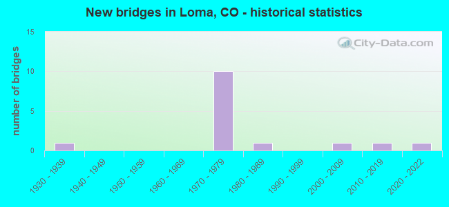
- New bridges - historical statistics
- 11930-1939
- 101970-1979
- 11980-1989
- 12000-2009
- 12010-2019
- 12020-2022

- Reconstructed bridges - Historical Statistics
- 11960-1969
- 11970-1979


- Bridge Condition - Deck
- 16.7%Very good
- 33.3%Good
- 50.0%Satisfactory

- Bridge Condition - Superstructure
- 16.7%Very good
- 33.3%Good
- 41.7%Satisfactory
- 8.3%Fair

- Bridge Condition - Substructure
- 8.3%Very good
- 50.0%Good
- 33.3%Satisfactory
- 8.3%Fair

- Bridge Condition - Channel
- 77.8%Very good
- 11.1%Good
- 11.1%Satisfactory
Find on map >> Show street view
Structure Number: G-01-D, Location: 5.7 MI N JCT I70-A (Lat: 39.264736, Lng: -108.812750), Route carried "on" structure: State highway 139A, Year Built: 1930, Year Reconstructed: 1976, Status: Open, Structure Length: 1.31m (4.30ft), Average Daily Traffic: 720 (year 2020), Truck Traffic: 15%, Average Future Daily Traffic: 986 (year 2040), Design Load: HS 20+Mod, Features Intersected: HIGHLINE CANAL, Facility Carried by Structure: SH 139 ML
Minimum Vertical Clearance: 30+ m (98+ ft), Kilometerpoint: 9.737, Lanes on structure: 2, Base Highway Network: Yes, Owner: State Highway Agency, Approaching Roadway Width: 11.0m (36.1ft), Skew: 4 degrees, Material/Design: Steel continuous, Design/Construction: Stringer/Multi-beam, Number Of Spans In Main Unit: 2, Length of Maximum Span: 6.1m (20.0ft), Curb-To-Curb Width: 8.8m (28.9ft), Out-to-Out Width: 9.1m (29.9ft)
Condition: Deck: Good, Superstructure: Satisfactory, Substructure: Satisfactory, Channel: Very good, Operating Rating: 37.2 metric tons, Method Used To Determine Operating Rating: Load Factor (LF), Inventory Rating: 21.8 metric tons, Method Used To Determine Inventory Rating: Load Factor (LF), Structural Evaluation: Somewhat better than minimum adequacy, Deck Geometry: Somewhat better than minimum adequacy, Waterway Adequacy: Equal to present desirable criteria, Approach Roadway Alignment: Equal to present desirable criteria, Designated Inspection Frequency: Every 24 months, Inspection Date: Febuary 2020, Deck Structure Type: Corrugated Steel, Wearing Surface/Protective System: Wearing Surface: Bituminous
Find on map >> Show street view
Structure Number: H-01-AA, Location: 13.5 MI E UTAH - LOMA int (Lat: 39.177789, Lng: -108.813303), Route carried "on" structure: State highway 139A, Year Built: 1970, Year Reconstructed: 1973, Status: Open, Structure Length: 7.38m (24.21ft), Average Daily Traffic: 1,700 (year 2020), Truck Traffic: 5%, Average Future Daily Traffic: 2,278 (year 2040), Design Load: HS 20, Features Intersected: I 70 ML, Facility Carried by Structure: SH 139 ML
Minimum Vertical Clearance: 30+ m (98+ ft), Kilometerpoint: 0.066, Lanes on structure: 2, Lanes under structure: 4, Base Highway Network: Yes, Owner: State Highway Agency, Approaching Roadway Width: 9.8m (32.2ft), Material/Design: Steel continuous, Design/Construction: Stringer/Multi-beam, Number Of Spans In Main Unit: 2, Length of Maximum Span: 36.3m (119.1ft), Curb-To-Curb Width: 13.4m (44.0ft), Out-to-Out Width: 14.2m (46.6ft)
Condition: Deck: Satisfactory, Superstructure: Satisfactory, Substructure: Satisfactory, Operating Rating: 25.9 metric tons, Method Used To Determine Operating Rating: Load and Resistance Factor Rating (LRFR) rating reported by rating factor(RF) method using HL-93 loadings, Inventory Rating: 19.4 metric tons, Method Used To Determine Inventory Rating: Load and Resistance Factor Rating (LRFR) rating reported by rating factor(RF) method using HL-93 loadings, Structural Evaluation: Somewhat better than minimum adequacy, Deck Geometry: Equal to present desirable criteria, Underclear: Equal to present minimum criteria, Approach Roadway Alignment: Equal to present desirable criteria, Length Of Structure Improvement: 7.38m (24.21ft), Designated Inspection Frequency: Every 24 months, Inspection Date: June 2020, Bridge Improvement Cost: $3,712,000, Roadway Improvement Cost: $371,000, Total Project Cost: $5,568,000 ( Estimate for 2016), Deck Structure Type: Concrete Cast-file-Place, Wearing Surface/Protective System: Wearing Surface: Bituminous, Membrane: Preformed Fabric
Find on map >> Show street view
Structure Number: H-01-AF, Location: 11.2 MI. E. COLO.-UTAH S. (Lat: 39.214528, Lng: -108.868114), Route carried "on" structure: Interstate 70A, Year Built: 1973, Status: Open, Structure Length: 4.18m (13.71ft), Average Daily Traffic: 4,200 (year 2020), Truck Traffic: 20%, Average Future Daily Traffic: 5,418 (year 2040), Design Load: HS 20, Features Intersected: US 6 ML, Facility Carried by Structure: I 70 ML WBND
Minimum Vertical Clearance: 30+ m (98+ ft), Kilometerpoint: 17.700, Lanes on structure: 2, Lanes under structure: 2, Base Highway Network: Yes, Owner: State Highway Agency, Approaching Roadway Width: 11.6m (38.1ft), Skew: 11 degrees, Material/Design: Concrete continuous, Design/Construction: Tee Beam, Number Of Spans In Main Unit: 3, Length of Maximum Span: 18.6m (61.0ft), Curb-To-Curb Width: 12.8m (42.0ft), Out-to-Out Width: 13.6m (44.6ft)
Condition: Deck: Satisfactory, Superstructure: Fair, Substructure: Good, Operating Rating: 50.8 metric tons, Method Used To Determine Operating Rating: Load Factor (LF), Inventory Rating: 30.5 metric tons, Method Used To Determine Inventory Rating: Load Factor (LF), Structural Evaluation: Somewhat better than minimum adequacy, Deck Geometry: Equal to present desirable criteria, Underclear: Better than present minimum criteria, Approach Roadway Alignment: Equal to present desirable criteria, Designated Inspection Frequency: Every 24 months, Inspection Date: June 2020, Deck Structure Type: Other, Wearing Surface/Protective System: Wearing Surface: Bituminous
Find on map >> Show street view
Structure Number: H-01-AG, Location: 11.1 MI E COLO-UTAH SL (Lat: 39.213711, Lng: -108.868764), Route carried "on" structure: Interstate 70A, Year Built: 1973, Status: Open, Structure Length: 4.18m (13.71ft), Average Daily Traffic: 4,200 (year 2020), Truck Traffic: 20%, Average Future Daily Traffic: 5,418 (year 2040), Design Load: HS 20, Features Intersected: US 6 ML, Facility Carried by Structure: I 70 ML EBND
Minimum Vertical Clearance: 30+ m (98+ ft), Kilometerpoint: 17.722, Lanes on structure: 2, Lanes under structure: 2, Base Highway Network: Yes, Owner: State Highway Agency, Approaching Roadway Width: 11.6m (38.1ft), Skew: 11 degrees, Material/Design: Concrete continuous, Design/Construction: Tee Beam, Number Of Spans In Main Unit: 3, Length of Maximum Span: 18.6m (61.0ft), Curb-To-Curb Width: 12.8m (42.0ft), Out-to-Out Width: 13.6m (44.6ft)
Condition: Deck: Good, Superstructure: Good, Substructure: Good, Operating Rating: 52.0 metric tons, Method Used To Determine Operating Rating: Load Factor (LF), Inventory Rating: 31.2 metric tons, Method Used To Determine Inventory Rating: Load Factor (LF), Structural Evaluation: Better than present minimum criteria, Deck Geometry: Equal to present desirable criteria, Underclear: Better than present minimum criteria, Approach Roadway Alignment: Equal to present desirable criteria, Designated Inspection Frequency: Every 24 months, Inspection Date: June 2020, Deck Structure Type: Other, Wearing Surface/Protective System: Wearing Surface: Bituminous
Find on map >> Show street view
Structure Number: H-01-AH, Location: 0.3 MI. W. JCT. SH 6 MACK (Lat: 39.223361, Lng: -108.890997), Route carried "on" structure: Interstate 70A, Year Built: 1971, Status: Open, Structure Length: 10.36m (33.99ft), Average Daily Traffic: 4,200 (year 2020), Truck Traffic: 20%, Average Future Daily Traffic: 5,418 (year 2040), Design Load: HS 20, Features Intersected: RR, SALT CREEK, Facility Carried by Structure: I 70 ML WBND
Minimum Vertical Clearance: 30+ m (98+ ft), Kilometerpoint: 15.516, Lanes on structure: 2, Base Highway Network: Yes, Owner: State Highway Agency, Approaching Roadway Width: 11.6m (38.1ft), Skew: 12 degrees, Material/Design: Steel continuous, Design/Construction: Stringer/Multi-beam, Number Of Spans In Main Unit: 3, Length of Maximum Span: 37.8m (124.0ft), Curb-To-Curb Width: 12.8m (42.0ft), Out-to-Out Width: 13.6m (44.6ft)
Condition: Deck: Good, Superstructure: Good, Substructure: Good, Channel: Very good, Operating Rating: 37.4 metric tons, Method Used To Determine Operating Rating: Load Factor (LF), Inventory Rating: 22.4 metric tons, Method Used To Determine Inventory Rating: Load Factor (LF), Structural Evaluation: Somewhat better than minimum adequacy, Deck Geometry: Equal to present desirable criteria, Underclear: Superior to present desirable criteria, Waterway Adequacy: Superior to present desirable criteria, Approach Roadway Alignment: Equal to present desirable criteria, Designated Inspection Frequency: Every 24 months, Inspection Date: June 2020, Deck Structure Type: Concrete Cast-file-Place, Wearing Surface/Protective System: Wearing Surface: Bituminous, Deck Protection: Galvanized Reinforcing
Find on map >> Show street view
Structure Number: H-01-AI, Location: 9.8 MI. E. COLO.-UTAH S.L (Lat: 39.223100, Lng: -108.891364), Route carried "on" structure: Interstate 70A, Year Built: 1971, Status: Open, Structure Length: 10.37m (34.02ft), Average Daily Traffic: 4,200 (year 2020), Truck Traffic: 20%, Average Future Daily Traffic: 5,418 (year 2040), Design Load: HS 20, Features Intersected: RR, SALT CREEK, Facility Carried by Structure: I 70 ML EBND
Minimum Vertical Clearance: 30+ m (98+ ft), Kilometerpoint: 15.500, Lanes on structure: 2, Base Highway Network: Yes, Owner: State Highway Agency, Approaching Roadway Width: 11.6m (38.1ft), Skew: 12 degrees, Material/Design: Steel continuous, Design/Construction: Stringer/Multi-beam, Number Of Spans In Main Unit: 3, Length of Maximum Span: 38.0m (124.7ft), Curb-To-Curb Width: 12.8m (42.0ft), Out-to-Out Width: 13.6m (44.6ft)
Condition: Deck: Satisfactory, Superstructure: Satisfactory, Substructure: Satisfactory, Channel: Very good, Operating Rating: 40.6 metric tons, Method Used To Determine Operating Rating: Load Factor (LF), Inventory Rating: 24.2 metric tons, Method Used To Determine Inventory Rating: Load Factor (LF), Structural Evaluation: Somewhat better than minimum adequacy, Deck Geometry: Equal to present desirable criteria, Underclear: Superior to present desirable criteria, Waterway Adequacy: Equal to present desirable criteria, Approach Roadway Alignment: Equal to present desirable criteria, Designated Inspection Frequency: Every 24 months, Inspection Date: June 2020, Deck Structure Type: Concrete Cast-file-Place, Wearing Surface/Protective System: Wearing Surface: Bituminous
Find on map >> Show street view
Structure Number: H-01-I, Location: 0.6 MI E OF JCT SH 139 (Lat: 39.175736, Lng: -108.800644), Route carried "on" structure: Interstate 70A, Year Built: 1970, Status: Open, Structure Length: 3.06m (10.04ft), Average Daily Traffic: 5,500 (year 2020), Truck Traffic: 23%, Average Future Daily Traffic: 6,985 (year 2040), Design Load: HS 20, Features Intersected: REED DRAIN, Facility Carried by Structure: I 70 ML WBND
Minimum Vertical Clearance: 30+ m (98+ ft), Kilometerpoint: 25.254, Lanes on structure: 2, Base Highway Network: Yes, Owner: State Highway Agency, Approaching Roadway Width: 11.6m (38.1ft), Skew: 10 degrees, Material/Design: Steel, Design/Construction: Stringer/Multi-beam, Number Of Spans In Main Unit: 1, Length of Maximum Span: 29.6m (97.1ft), Curb-To-Curb Width: 12.0m (39.4ft), Out-to-Out Width: 12.8m (42.0ft)
Condition: Deck: Satisfactory, Superstructure: Satisfactory, Substructure: Satisfactory, Channel: Very good, Operating Rating: 52.1 metric tons, Method Used To Determine Operating Rating: Load Factor (LF), Inventory Rating: 31.2 metric tons, Method Used To Determine Inventory Rating: Load Factor (LF), Structural Evaluation: Equal to present minimum criteria, Deck Geometry: Equal to present minimum criteria, Waterway Adequacy: Equal to present desirable criteria, Approach Roadway Alignment: Equal to present desirable criteria, Designated Inspection Frequency: Every 24 months, Inspection Date: June 2020, Deck Structure Type: Concrete Cast-file-Place, Wearing Surface/Protective System: Wearing Surface: Bituminous
Find on map >> Show street view
Structure Number: H-01-J, Location: 0.6 MI E OF JCT SH 139 (Lat: 39.175447, Lng: -108.800939), Route carried "on" structure: Interstate 70A, Year Built: 1970, Status: Open, Structure Length: 3.06m (10.04ft), Average Daily Traffic: 5,500 (year 2020), Truck Traffic: 23%, Average Future Daily Traffic: 6,985 (year 2040), Design Load: HS 20+Mod, Features Intersected: REED DRAIN, Facility Carried by Structure: I 70 ML EBND
Minimum Vertical Clearance: 30+ m (98+ ft), Kilometerpoint: 25.255, Lanes on structure: 2, Base Highway Network: Yes, Owner: State Highway Agency, Approaching Roadway Width: 11.6m (38.1ft), Skew: 10 degrees, Material/Design: Steel, Design/Construction: Stringer/Multi-beam, Number Of Spans In Main Unit: 1, Length of Maximum Span: 29.6m (97.1ft), Curb-To-Curb Width: 12.0m (39.4ft), Out-to-Out Width: 12.8m (42.0ft)
Condition: Deck: Good, Superstructure: Good, Substructure: Good, Channel: Good, Operating Rating: 54.5 metric tons, Method Used To Determine Operating Rating: Load Factor (LF), Inventory Rating: 32.7 metric tons, Method Used To Determine Inventory Rating: Load Factor (LF), Structural Evaluation: Better than present minimum criteria, Deck Geometry: Equal to present minimum criteria, Waterway Adequacy: Equal to present desirable criteria, Approach Roadway Alignment: Equal to present desirable criteria, Designated Inspection Frequency: Every 24 months, Inspection Date: June 2020, Deck Structure Type: Concrete Cast-file-Place, Wearing Surface/Protective System: Wearing Surface: Bituminous
Find on map >> Show street view
Structure Number: MESA-14-M.3, Location: 0.7 MI N of US50 (Lat: 39.197500, Lng: -108.794167), Route carried "on" structure: County highway , Year Built: 2016, Status: Open, Structure Length: 2.35m (7.71ft), Average Daily Traffic: 826 (year 2018), Average Future Daily Traffic: 1,247 (year 2038), Design Load: HS 20, Features Intersected: REED WASH, Facility Carried by Structure: COUNTY ROAD 14
Minimum Vertical Clearance: 30+ m (98+ ft), Kilometerpoint: 1.191, Lanes on structure: 2, Owner: County Highway Agency, Approaching Roadway Width: 6.7m (22.0ft), Skew: 3 degrees, Material/Design: Prestressed concrete, Design/Construction: Stringer/Multi-beam, Number Of Spans In Main Unit: 1, Length of Maximum Span: 21.6m (70.9ft), Curb-To-Curb Width: 11.6m (38.1ft), Out-to-Out Width: 12.5m (41.0ft)
Condition: Deck: Very good, Superstructure: Very good, Substructure: Very good, Channel: Very good, Operating Rating: 48.6 metric tons, Method Used To Determine Operating Rating: Load and Resistance Factor Rating (LRFR) rating reported by rating factor(RF) method using HL-93 loadings, Inventory Rating: 33.4 metric tons, Method Used To Determine Inventory Rating: Load and Resistance Factor Rating (LRFR) rating reported by rating factor(RF) method using HL-93 loadings, Structural Evaluation: Equal to present desirable criteria, Deck Geometry: Better than present minimum criteria, Waterway Adequacy: Equal to present desirable criteria, Approach Roadway Alignment: Equal to present desirable criteria, Designated Inspection Frequency: Every 24 months, Inspection Date: March 2020, Deck Structure Type: Concrete Cast-file-Place, Wearing Surface/Protective System: Wearing Surface: Bituminous, Deck Protection: Epoxy Coated Reinforcing
Find on map >> Show street view
Structure Number: MESA-16-Q.5-A, Location: 0.5 MI N OF RD Q (Lat: 39.256711, Lng: -108.756772), Route carried "on" structure: County highway , Year Built: 2020, Status: Open, Structure Length: 1.87m (6.14ft), Average Daily Traffic: 279 (year 2018), Truck Traffic: 2%, Average Future Daily Traffic: 421 (year 2038), Design Load: HL 93, Features Intersected: GOVT. HIGHLINE CANAL, Facility Carried by Structure: COUNTY ROAD 16
Minimum Vertical Clearance: 30+ m (98+ ft), Kilometerpoint: 9.900, Lanes on structure: 2, Owner: County Highway Agency, Approaching Roadway Width: 6.8m (22.3ft), Skew: 4 degrees, Material/Design: Steel, Design/Construction: Stringer/Multi-beam, Number Of Spans In Main Unit: 1, Length of Maximum Span: 15.8m (51.8ft), Curb-To-Curb Width: 17.4m (57.1ft), Out-to-Out Width: 18.3m (60.0ft)
Condition: Deck: Very good, Superstructure: Very good, Substructure: Good, Channel: Very good, Operating Rating: 62.5 metric tons, Method Used To Determine Operating Rating: Load and Resistance Factor Rating (LRFR) rating reported by rating factor(RF) method using HL-93 loadings, Inventory Rating: 48.3 metric tons, Method Used To Determine Inventory Rating: Load and Resistance Factor Rating (LRFR) rating reported by rating factor(RF) method using HL-93 loadings, Structural Evaluation: Better than present minimum criteria, Deck Geometry: Superior to present desirable criteria, Waterway Adequacy: Equal to present desirable criteria, Approach Roadway Alignment: Equal to present desirable criteria, Designated Inspection Frequency: Every 24 months, Inspection Date: January 2022, Deck Structure Type: Concrete Cast-file-Place, Wearing Surface/Protective System: Wearing Surface: Bituminous
Find on map >> Show street view
Structure Number: MESA-18-Q.01A, Location: 8.9 MI NE OF JCT US 6 (Lat: 39.251250, Lng: -108.719611), Route carried "on" structure: County highway , Year Built: 1983, Status: Open, Structure Length: 0.92m (3.02ft), Average Daily Traffic: 364 (year 2018), Truck Traffic: 2%, Average Future Daily Traffic: 549 (year 2038), Features Intersected: GOVT. HIGHLINE CANAL, Facility Carried by Structure: COUNTY ROAD 18
Minimum Vertical Clearance: 30+ m (98+ ft), Kilometerpoint: 4.423, Lanes on structure: 2, Owner: County Highway Agency, Approaching Roadway Width: 6.7m (22.0ft), Material/Design: Steel, Design/Construction: Stringer/Multi-beam, Number Of Spans In Main Unit: 1, Length of Maximum Span: 8.8m (28.9ft), Curb-To-Curb Width: 9.1m (29.9ft), Out-to-Out Width: 9.4m (30.8ft)
Condition: Deck: Satisfactory, Superstructure: Satisfactory, Substructure: Fair, Channel: Satisfactory, Operating Rating: 57.4 metric tons, Method Used To Determine Operating Rating: Load Factor (LF), Inventory Rating: 34.4 metric tons, Method Used To Determine Inventory Rating: Load Factor (LF), Structural Evaluation: Somewhat better than minimum adequacy, Deck Geometry: Equal to present minimum criteria, Waterway Adequacy: Equal to present desirable criteria, Approach Roadway Alignment: Equal to present desirable criteria, Designated Inspection Frequency: Every 24 months, Inspection Date: January 2022, Deck Structure Type: Corrugated Steel, Wearing Surface/Protective System: Wearing Surface: Bituminous
Find on map >> Show street view
Structure Number: MESA-O.4-9.6A, Location: .4 MI W OF CR 10.0 (Lat: 39.229111, Lng: -108.875611), Route carried "on" structure: County highway , Year Built: 2001, Status: Open, Structure Length: 2.97m (9.74ft), Average Daily Traffic: 725 (year 2018), Truck Traffic: 2%, Average Future Daily Traffic: 1,095 (year 2038), Design Load: HS 25 or greater, Features Intersected: MACK WASH, Facility Carried by Structure: COUNTY ROAD M.80
Minimum Vertical Clearance: 30+ m (98+ ft), Kilometerpoint: 17.407, Lanes on structure: 2, Owner: County Highway Agency, Approaching Roadway Width: 7.2m (23.6ft), Material/Design: Prestressed concrete, Design/Construction: Stringer/Multi-beam, Number Of Spans In Main Unit: 1, Length of Maximum Span: 28.2m (92.5ft), Curb-To-Curb Width: 10.4m (34.1ft), Out-to-Out Width: 11.3m (37.1ft)
Condition: Deck: Satisfactory, Superstructure: Good, Substructure: Good, Channel: Very good, Operating Rating: 88.5 metric tons, Method Used To Determine Operating Rating: Load Factor (LF), Inventory Rating: 53.0 metric tons, Method Used To Determine Inventory Rating: Load Factor (LF), Structural Evaluation: Better than present minimum criteria, Deck Geometry: Equal to present minimum criteria, Waterway Adequacy: Equal to present desirable criteria, Approach Roadway Alignment: Equal to present desirable criteria, Designated Inspection Frequency: Every 24 months, Inspection Date: January 2022, Deck Structure Type: Concrete Cast-file-Place, Wearing Surface/Protective System: Wearing Surface: Monolithic Concrete, Deck Protection: Epoxy Coated Reinforcing
Find on map >> Show street view
Structure Number: H-01-AA, Location: 13.5 MI E UTAH - LOMA int (Lat: 39.177789, Lng: -108.813303), Route carried "under" structure: Interstate 70A, Year Built: 1970, Structure Length: 0. m, Average Daily Traffic: 6,300 (year 2011), Truck Traffic: 23%, Features Intersected: I 70 ML, Facility Carried by Structure: SH 139 ML
Minimum Vertical Clearance: 5.31m (17.42ft), Kilometerpoint: 24.265, Lanes on structure: 2, Lanes under structure: 4, Material/Design: Steel continuous, Design/Construction: Stringer/Multi-beam, Length of Maximum Span: 36.3m (119.1ft)
Find on map >> Show street view
Structure Number: H-01-AF, Location: 11.2 MI. E. COLO.-UTAH S. (Lat: 39.214528, Lng: -108.868114), Route carried "under" structure: US 6A, Year Built: 1973, Structure Length: 0. m, Average Daily Traffic: 650 (year 2011), Truck Traffic: 12%, Features Intersected: US 6 ML, Facility Carried by Structure: I 70 ML WBND
Minimum Vertical Clearance: 4.98m (16.34ft), Kilometerpoint: 17.991, Lanes on structure: 2, Lanes under structure: 2, Material/Design: Concrete continuous, Design/Construction: Tee Beam, Length of Maximum Span: 18.6m (61.0ft)
Find on map >> Show street view
Structure Number: H-01-AG, Location: 11.1 MI E COLO-UTAH SL (Lat: 39.213711, Lng: -108.868764), Route carried "under" structure: US 6A, Year Built: 1973, Structure Length: 0. m, Average Daily Traffic: 650 (year 2011), Truck Traffic: 12%, Features Intersected: US 6 ML, Facility Carried by Structure: I 70 ML EBND
Minimum Vertical Clearance: 5.03m (16.50ft), Kilometerpoint: 17.991, Lanes on structure: 2, Lanes under structure: 2, Material/Design: Concrete continuous, Design/Construction: Tee Beam, Length of Maximum Span: 18.6m (61.0ft)