Bridge Statistics for Lumberton, Texas (TX)
Condition, Traffic, Stress, Structural Evaluation, Project Costs
- National Bridge Inventory (NBI) Statistics
- 34Number of bridges
- 679ft / 207mTotal length
- $144,000Total costs
- 348,205Total average daily traffic
- 31,249Total average daily truck traffic
- National Bridge Inventory (NBI) Registered Bridges for Lumberton
- No street view available for this location
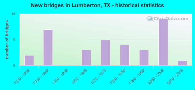
- New bridges - historical statistics
- 21930-1939
- 71940-1949
- 31960-1969
- 51970-1979
- 41980-1989
- 31990-1999
- 92000-2009
- 12010-2019

- Reconstructed bridges - Historical Statistics
- 11950-1959
- 01960-1969
- 21970-1979
- 01980-1989
- 41990-1999
- 22000-2009


- Bridge Condition - Deck
- 7.7%Excellent
- 7.7%Very good
- 30.8%Good
- 53.8%Satisfactory

- Bridge Condition - Superstructure
- 7.7%Excellent
- 15.4%Very good
- 38.5%Good
- 38.5%Satisfactory

- Bridge Condition - Substructure
- 7.7%Excellent
- 38.5%Good
- 46.2%Satisfactory
- 7.7%Fair

- Bridge Condition - Channel
- 10.0%Very good
- 43.3%Good
- 40.0%Satisfactory
- 6.7%Fair

- Bridge Condition - Culverts
- 73.7%Good
- 26.3%Satisfactory
Find on map >> Show street view
Structure Number: 201010006505058, Location: 5.15 MI N OF US 69 (Lat: 30.291522, Lng: -94.186247), Route carried "on" structure: US 96, Year Built: 1949, Status: Open, Structure Length: 6.10m (20.01ft), Average Daily Traffic: 11,204 (year 2016), Truck Traffic: 10%, Average Future Daily Traffic: 14,710 (year 2033), Design Load: H 20, Features Intersected: VILLAGE CREEK RELIEF
Minimum Vertical Clearance: 30+ m (98+ ft), Kilometerpoint: 15.036, Lanes on structure: 2, Owner: State Highway Agency, Approaching Roadway Width: 13.4m (44.0ft), Material/Design: Concrete, Design/Construction: Slab, Number Of Spans In Main Unit: 8, Length of Maximum Span: 7.6m (24.9ft), Curb-To-Curb Width: 11.9m (39.0ft), Out-to-Out Width: 12.7m (41.7ft)
Condition: Deck: Satisfactory, Superstructure: Satisfactory, Substructure: Satisfactory, Channel: Good, Operating Rating: 49.9 metric tons, Method Used To Determine Operating Rating: Load Factor (LF), Inventory Rating: 29.9 metric tons, Method Used To Determine Inventory Rating: Load Factor (LF), Structural Evaluation: Equal to present minimum criteria, Deck Geometry: Better than present minimum criteria, Waterway Adequacy: Superior to present desirable criteria, Approach Roadway Alignment: Equal to present desirable criteria, Designated Inspection Frequency: Every 24 months, Inspection Date: April 2020, Deck Structure Type: Concrete Cast-file-Place, Wearing Surface/Protective System: Wearing Surface: Bituminous
Find on map >> Show street view
Structure Number: 201010006505059, Location: 4.55 MI N OF US 69 (Lat: 30.284983, Lng: -94.192669), Route carried "on" structure: US 96, Year Built: 1949, Status: Open, Structure Length: 50.96m (167.19ft), Average Daily Traffic: 11,204 (year 2016), Truck Traffic: 10%, Average Future Daily Traffic: 14,710 (year 2033), Design Load: H 20, Features Intersected: VILLAGE CREEK
Minimum Vertical Clearance: 30+ m (98+ ft), Kilometerpoint: 15.530, Lanes on structure: 2, Owner: State Highway Agency, Approaching Roadway Width: 13.4m (44.0ft), Material/Design: Steel continuous, Design/Construction: Stringer/Multi-beam, Number Of Spans In Main Unit: 3, Number Of Approach Spans: 36, Length of Maximum Span: 27.4m (89.9ft), Curb-To-Curb Width: 8.2m (26.9ft), Out-to-Out Width: 9.4m (30.8ft)
Condition: Deck: Satisfactory, Superstructure: Satisfactory, Substructure: Satisfactory, Channel: Satisfactory, Operating Rating: 41.7 metric tons, Method Used To Determine Operating Rating: Load Factor (LF), Inventory Rating: 24.5 metric tons, Method Used To Determine Inventory Rating: Load Factor (LF), Structural Evaluation: Equal to present minimum criteria, Deck Geometry: High priority of corrective action, Waterway Adequacy: Superior to present desirable criteria, Approach Roadway Alignment: Equal to present desirable criteria, Length Of Structure Improvement: 50.96m (167.19ft), Designated Inspection Frequency: Every 24 months, Inspection Date: May 2020, Bridge Improvement Cost: $94,000, Roadway Improvement Cost: $24,000, Total Project Cost: $118,000, Deck Structure Type: Concrete Cast-file-Place, Wearing Surface/Protective System: Wearing Surface: Bituminous
Find on map >> Show street view
Structure Number: 20101000650506, Location: 3.95 MI N OF US 69 (Lat: 30.277814, Lng: -94.197008), Route carried "on" structure: US 96, Year Built: 1949, Year Reconstructed: 1981, Status: Open, Structure Length: 5.33m (17.49ft), Average Daily Traffic: 22,891 (year 2016), Truck Traffic: 10%, Average Future Daily Traffic: 29,420 (year 2033), Design Load: H 20, Features Intersected: WALTON CREEK
Minimum Vertical Clearance: 30+ m (98+ ft), Kilometerpoint: 16.942, Lanes on structure: 5, Owner: State Highway Agency, Approaching Roadway Width: 24.4m (80.1ft), Material/Design: Concrete, Design/Construction: Slab, Number Of Spans In Main Unit: 7, Length of Maximum Span: 7.6m (24.9ft), Curb-To-Curb Width: 24.5m (80.4ft), Out-to-Out Width: 25.1m (82.3ft)
Condition: Deck: Good, Superstructure: Good, Substructure: Satisfactory, Channel: Satisfactory, Operating Rating: 49.0 metric tons, Method Used To Determine Operating Rating: Load Factor (LF), Inventory Rating: 29.0 metric tons, Method Used To Determine Inventory Rating: Load Factor (LF), Structural Evaluation: Equal to present minimum criteria, Deck Geometry: Superior to present desirable criteria, Waterway Adequacy: Superior to present desirable criteria, Approach Roadway Alignment: Equal to present desirable criteria, Designated Inspection Frequency: Every 24 months, Inspection Date: April 2020, Deck Structure Type: Concrete Cast-file-Place, Wearing Surface/Protective System: Wearing Surface: Bituminous
Find on map >> Show street view
Structure Number: 201010006505061, Location: 1.60 MI N OF US 69 (Lat: 30.244950, Lng: -94.196425), Route carried "on" structure: US 96, Year Built: 1948, Year Reconstructed: 1975, Status: Open, Structure Length: 0.70m (2.30ft), Average Daily Traffic: 28,926 (year 2016), Truck Traffic: 11%, Average Future Daily Traffic: 36,590 (year 2033), Design Load: H 15, Features Intersected: DRAINAGE DITCH
Minimum Vertical Clearance: 30+ m (98+ ft), Kilometerpoint: 20.719, Lanes on structure: 5, Owner: State Highway Agency, Approaching Roadway Width: 22.6m (74.1ft), Material/Design: Concrete, Design/Construction: Culvert, Number Of Spans In Main Unit: 4, Length of Maximum Span: 1.5m (4.9ft)
Condition: Channel: Good, Culverts: Good, Operating Rating: 39.9 metric tons, Method Used To Determine Operating Rating: Load Factor (LF), Inventory Rating: 23.6 metric tons, Method Used To Determine Inventory Rating: Load Factor (LF), Structural Evaluation: Somewhat better than minimum adequacy, Waterway Adequacy: Equal to present minimum criteria, Approach Roadway Alignment: Equal to present desirable criteria, Designated Inspection Frequency: Every 24 months, Inspection Date: March 2020
Find on map >> Show street view
Structure Number: 201010006505103, Location: 5.40 MI N OF US 69 (Lat: 30.296581, Lng: -94.185442), Route carried "on" structure: US 96, Year Built: 1970, Status: Open, Structure Length: 9.14m (29.99ft), Average Daily Traffic: 11,687 (year 2016), Truck Traffic: 10%, Average Future Daily Traffic: 14,710 (year 2033), Design Load: HS 20, Features Intersected: VILLAGE CREEK N RELIEF
Minimum Vertical Clearance: 30+ m (98+ ft), Kilometerpoint: 14.528, Lanes on structure: 2, Owner: State Highway Agency, Approaching Roadway Width: 12.5m (41.0ft), Material/Design: Prestressed concrete, Design/Construction: Stringer/Multi-beam, Number Of Spans In Main Unit: 6, Length of Maximum Span: 15.2m (49.9ft), Curb-To-Curb Width: 12.6m (41.3ft), Out-to-Out Width: 13.5m (44.3ft)
Condition: Deck: Good, Superstructure: Very good, Substructure: Satisfactory, Channel: Good, Operating Rating: 68.0 metric tons, Method Used To Determine Operating Rating: Load Factor (LF), Inventory Rating: 40.8 metric tons, Method Used To Determine Inventory Rating: Load Factor (LF), Structural Evaluation: Equal to present minimum criteria, Deck Geometry: Better than present minimum criteria, Waterway Adequacy: Superior to present desirable criteria, Approach Roadway Alignment: Equal to present desirable criteria, Designated Inspection Frequency: Every 24 months, Inspection Date: April 2020, Deck Structure Type: Concrete Cast-file-Place, Wearing Surface/Protective System: Wearing Surface: Bituminous
Find on map >> Show street view
Structure Number: 201010006505123, Location: 5.15 MI N OF US 69 (Lat: 30.292050, Lng: -94.186347), Route carried "on" structure: US 96, Year Built: 1981, Status: Open, Structure Length: 6.10m (20.01ft), Average Daily Traffic: 11,687 (year 2016), Truck Traffic: 10%, Average Future Daily Traffic: 14,710 (year 2033), Design Load: HS 20, Features Intersected: VILLAGE CREEK RELIEF
Minimum Vertical Clearance: 30+ m (98+ ft), Kilometerpoint: 15.036, Lanes on structure: 2, Owner: State Highway Agency, Approaching Roadway Width: 12.5m (41.0ft), Material/Design: Prestressed concrete continuous, Design/Construction: Stringer/Multi-beam, Number Of Spans In Main Unit: 4, Length of Maximum Span: 15.2m (49.9ft), Curb-To-Curb Width: 11.3m (37.1ft), Out-to-Out Width: 12.2m (40.0ft)
Condition: Deck: Satisfactory, Superstructure: Satisfactory, Substructure: Good, Channel: Good, Operating Rating: 44.4 metric tons, Method Used To Determine Operating Rating: Assigned ratings based on Allowable Stress Design (ASD) reported in metric tons, Inventory Rating: 32.7 metric tons, Method Used To Determine Inventory Rating: Assigned ratings based on Allowable Stress Design (ASD) reported in metric tons, Structural Evaluation: Equal to present minimum criteria, Deck Geometry: Equal to present minimum criteria, Waterway Adequacy: Superior to present desirable criteria, Approach Roadway Alignment: Equal to present desirable criteria, Designated Inspection Frequency: Every 24 months, Inspection Date: April 2020, Deck Structure Type: Concrete Cast-file-Place
Find on map >> Show street view
Structure Number: 201010006505124, Location: 4.55 MI N OF US 69 (Lat: 30.285164, Lng: -94.192764), Route carried "on" structure: US 96, Year Built: 1981, Status: Open, Structure Length: 50.90m (166.99ft), Average Daily Traffic: 11,687 (year 2016), Truck Traffic: 10%, Average Future Daily Traffic: 14,710 (year 2033), Design Load: HS 20, Features Intersected: VILLAGE CREEK
Minimum Vertical Clearance: 30+ m (98+ ft), Kilometerpoint: 15.530, Lanes on structure: 2, Owner: State Highway Agency, Approaching Roadway Width: 12.5m (41.0ft), Material/Design: Prestressed concrete continuous, Design/Construction: Stringer/Multi-beam, Number Of Spans In Main Unit: 19, Number Of Approach Spans: 3, Length of Maximum Span: 27.4m (89.9ft), Curb-To-Curb Width: 11.3m (37.1ft), Out-to-Out Width: 12.2m (40.0ft)
Condition: Deck: Satisfactory, Superstructure: Good, Substructure: Good, Channel: Satisfactory, Operating Rating: 44.4 metric tons, Method Used To Determine Operating Rating: Assigned ratings based on Allowable Stress Design (ASD) reported in metric tons, Inventory Rating: 32.7 metric tons, Method Used To Determine Inventory Rating: Assigned ratings based on Allowable Stress Design (ASD) reported in metric tons, Structural Evaluation: Better than present minimum criteria, Deck Geometry: Equal to present minimum criteria, Waterway Adequacy: Superior to present desirable criteria, Approach Roadway Alignment: Equal to present desirable criteria, Designated Inspection Frequency: Every 24 months, Inspection Date: May 2020, Deck Structure Type: Concrete Cast-file-Place
Find on map >> Show street view
Structure Number: 201010006506082, Location: 2.75 MI N JEFFERSON C/L (Lat: 30.217858, Lng: -94.193017), Route carried "on" structure: ServiceUS 69, Year Built: 1966, Year Reconstructed: 1996, Status: Open, Structure Length: 1.37m (4.49ft), Average Daily Traffic: 3,050 (year 2013), Truck Traffic: 8%, Average Future Daily Traffic: 4,270 (year 2033), Features Intersected: DRAW
Minimum Vertical Clearance: 30+ m (98+ ft), Kilometerpoint: 0.164, Lanes on structure: 8, Owner: State Highway Agency, Approaching Roadway Width: 39.6m (129.9ft), Skew: 3 degrees, Material/Design: Concrete, Design/Construction: Culvert, Number Of Spans In Main Unit: 5, Length of Maximum Span: 2.1m (6.9ft)
Condition: Channel: Satisfactory, Culverts: Satisfactory, Operating Rating: 39.9 metric tons, Method Used To Determine Operating Rating: Load Factor (LF), Inventory Rating: 23.6 metric tons, Method Used To Determine Inventory Rating: Load Factor (LF), Structural Evaluation: Equal to present minimum criteria, Waterway Adequacy: Equal to present minimum criteria, Approach Roadway Alignment: Equal to present desirable criteria, Length Of Structure Improvement: 1.34m (4.40ft), Designated Inspection Frequency: Every 24 months, Inspection Date: March 2020, Bridge Improvement Cost: $6,000, Roadway Improvement Cost: $2,000, Total Project Cost: $8,000
Find on map >> Show street view
Structure Number: 201010006506129, Location: 2.75 MI N JEFFERSON C/L (Lat: 30.218242, Lng: -94.192958), Route carried "on" structure: US 69, Year Built: 1988, Status: Open, Structure Length: 34.90m (114.50ft), Average Daily Traffic: 40,237 (year 2019), Truck Traffic: 8%, Average Future Daily Traffic: 23,430 (year 2033), Design Load: HS 20, Features Intersected: MITCHELL RD
Minimum Vertical Clearance: 30+ m (98+ ft), Kilometerpoint: 0.000, Lanes on structure: 6, Lanes under structure: 4, Owner: State Highway Agency, Approaching Roadway Width: 32.0m (105.0ft), Skew: 39 degrees, Material/Design: Prestressed concrete, Design/Construction: Stringer/Multi-beam, Number Of Spans In Main Unit: 11, Length of Maximum Span: 35.1m (115.2ft), Curb-To-Curb Width: 33.2m (108.9ft), Out-to-Out Width: 34.7m (113.8ft)
Condition: Deck: Satisfactory, Superstructure: Satisfactory, Substructure: Satisfactory, Operating Rating: 54.4 metric tons, Method Used To Determine Operating Rating: Assigned rating based on Load Factor Design (LFD) reported in metric tons, Inventory Rating: 32.7 metric tons, Method Used To Determine Inventory Rating: Assigned rating based on Load Factor Design (LFD) reported in metric tons, Structural Evaluation: Equal to present minimum criteria, Deck Geometry: Superior to present desirable criteria, Underclear: Meets minimum limits, Approach Roadway Alignment: Equal to present desirable criteria, Designated Inspection Frequency: Every 24 months, Inspection Date: March 2020, Deck Structure Type: Concrete Precast Panels
Find on map >> Show street view
Structure Number: 201010020010051, Location: 1.0 MI S OF FM 421 (Lat: 30.229406, Lng: -94.200656), Route carried "on" structure: US 69, Year Built: 1942, Year Reconstructed: 1998, Status: Open, Structure Length: 0.70m (2.30ft), Average Daily Traffic: 20,300 (year 2020), Truck Traffic: 8%, Average Future Daily Traffic: 23,430 (year 2033), Design Load: H 15, Features Intersected: DRAIN
Minimum Vertical Clearance: 30+ m (98+ ft), Kilometerpoint: 19.212, Lanes on structure: 3, Owner: State Highway Agency, Approaching Roadway Width: 17.1m (56.1ft), Material/Design: Concrete, Design/Construction: Culvert, Number Of Spans In Main Unit: 3, Length of Maximum Span: 2.1m (6.9ft), Curb-To-Curb Width: 17.5m (57.4ft), Out-to-Out Width: 19.8m (65.0ft)
Condition: Channel: Fair, Culverts: Good, Operating Rating: 39.9 metric tons, Method Used To Determine Operating Rating: Load Factor (LF), Inventory Rating: 23.6 metric tons, Method Used To Determine Inventory Rating: Load Factor (LF), Structural Evaluation: Somewhat better than minimum adequacy, Deck Geometry: Superior to present desirable criteria, Waterway Adequacy: Equal to present minimum criteria, Approach Roadway Alignment: Equal to present desirable criteria, Designated Inspection Frequency: Every 24 months, Inspection Date: March 2020, Deck Structure Type: Concrete Cast-file-Place, Wearing Surface/Protective System: Wearing Surface: Bituminous
Find on map >> Show street view
Structure Number: 201010020010104, Location: 0.70 MI S OF FM 421 (Lat: 30.233497, Lng: -94.203603), Route carried "on" structure: US 69, Year Built: 1975, Year Reconstructed: 1998, Status: Open, Structure Length: 1.16m (3.81ft), Average Daily Traffic: 20,300 (year 2020), Truck Traffic: 8%, Average Future Daily Traffic: 23,430 (year 2033), Design Load: H 20, Features Intersected: DRAIN
Minimum Vertical Clearance: 30+ m (98+ ft), Kilometerpoint: 17.894, Lanes on structure: 3, Owner: State Highway Agency, Approaching Roadway Width: 17.4m (57.1ft), Material/Design: Concrete, Design/Construction: Culvert, Number Of Spans In Main Unit: 5, Length of Maximum Span: 1.8m (5.9ft)
Condition: Channel: Satisfactory, Culverts: Good, Operating Rating: 39.9 metric tons, Method Used To Determine Operating Rating: Load Factor (LF), Inventory Rating: 23.6 metric tons, Method Used To Determine Inventory Rating: Load Factor (LF), Structural Evaluation: Somewhat better than minimum adequacy, Waterway Adequacy: Equal to present minimum criteria, Approach Roadway Alignment: Equal to present desirable criteria, Designated Inspection Frequency: Every 24 months, Inspection Date: March 2020
Find on map >> Show street view
Structure Number: 201010020010105, Location: 1.00 MI S OF FM 421 (Lat: 30.230231, Lng: -94.201681), Route carried "on" structure: ServiceUS 69, Year Built: 1975, Year Reconstructed: 1998, Status: Open, Structure Length: 1.13m (3.71ft), Average Daily Traffic: 17,460 (year 2010), Truck Traffic: 15%, Average Future Daily Traffic: 26,050 (year 2030), Design Load: H 20, Features Intersected: US 69 PARALLEL DRAIN, Facility Carried by Structure: PARK NORTH RD
Minimum Vertical Clearance: 30+ m (98+ ft), Kilometerpoint: 19.076, Lanes on structure: 2, Owner: State Highway Agency, Approaching Roadway Width: 7.3m (24.0ft), Skew: 1 degrees, Material/Design: Concrete, Design/Construction: Culvert, Number Of Spans In Main Unit: 5, Length of Maximum Span: 1.8m (5.9ft), Curb-To-Curb Width: 7.9m (25.9ft), Out-to-Out Width: 9.8m (32.2ft)
Condition: Channel: Satisfactory, Culverts: Good, Operating Rating: 39.9 metric tons, Method Used To Determine Operating Rating: Load Factor (LF), Inventory Rating: 23.6 metric tons, Method Used To Determine Inventory Rating: Load Factor (LF), Structural Evaluation: Somewhat better than minimum adequacy, Deck Geometry: High priority of replacement, Waterway Adequacy: Equal to present minimum criteria, Approach Roadway Alignment: Equal to present desirable criteria, Length Of Structure Improvement: 1.10m (3.61ft), Designated Inspection Frequency: Every 24 months, Inspection Date: March 2020, Bridge Improvement Cost: $2,000, Roadway Improvement Cost: $1,000, Total Project Cost: $3,000, Deck Structure Type: Concrete Cast-file-Place, Wearing Surface/Protective System: Wearing Surface: Bituminous
Find on map >> Show street view
Structure Number: 201010020010122, Location: 1.55 MI S OF FM 421 (Lat: 30.223164, Lng: -94.193656), Route carried "on" structure: US 69, Year Built: 1975, Status: Open, Structure Length: 12.95m (42.49ft), Average Daily Traffic: 8,370 (year 2013), Truck Traffic: 8%, Average Future Daily Traffic: 11,710 (year 2033), Design Load: HS 20, Features Intersected: US 96 SB
Minimum Vertical Clearance: 30+ m (98+ ft), Kilometerpoint: 20.078, Lanes on structure: 2, Lanes under structure: 2, Owner: State Highway Agency, Approaching Roadway Width: 12.8m (42.0ft), Skew: 5 degrees, Material/Design: Prestressed concrete, Design/Construction: Stringer/Multi-beam, Number Of Spans In Main Unit: 1, Number Of Approach Spans: 4, Length of Maximum Span: 41.1m (134.8ft), Curb-To-Curb Width: 12.9m (42.3ft), Out-to-Out Width: 13.5m (44.3ft)
Condition: Deck: Good, Superstructure: Good, Substructure: Satisfactory, Operating Rating: 54.4 metric tons, Method Used To Determine Operating Rating: Assigned rating based on Load Factor Design (LFD) reported in metric tons, Inventory Rating: 32.7 metric tons, Method Used To Determine Inventory Rating: Assigned rating based on Load Factor Design (LFD) reported in metric tons, Structural Evaluation: Equal to present minimum criteria, Deck Geometry: Superior to present desirable criteria, Underclear: Better than present minimum criteria, Approach Roadway Alignment: Equal to present desirable criteria, Designated Inspection Frequency: Every 24 months, Inspection Date: March 2020, Deck Structure Type: Concrete Cast-file-Place
Find on map >> Show street view
Structure Number: 20101002001016, Location: 4.2 MI N OF FM 421 (Lat: 30.297903, Lng: -94.241300), Route carried "on" structure: US 69, Year Built: 2005, Status: Open, Structure Length: 1.10m (3.61ft), Average Daily Traffic: 9,610 (year 2016), Truck Traffic: 8%, Average Future Daily Traffic: 13,650 (year 2033), Design Load: HS 20, Features Intersected: DRAINAGE DITCH
Minimum Vertical Clearance: 30+ m (98+ ft), Kilometerpoint: 10.704, Lanes on structure: 3, Owner: State Highway Agency, Approaching Roadway Width: 17.7m (58.1ft), Skew: 4 degrees, Material/Design: Concrete, Design/Construction: Culvert, Number Of Spans In Main Unit: 4, Length of Maximum Span: 1.5m (4.9ft), Curb-To-Curb Width: 24.4m (80.1ft), Out-to-Out Width: 25.0m (82.0ft)
Condition: Channel: Very good, Culverts: Good, Operating Rating: 54.4 metric tons, Method Used To Determine Operating Rating: Assigned rating based on Load Factor Design (LFD) reported in metric tons, Inventory Rating: 32.7 metric tons, Method Used To Determine Inventory Rating: Assigned rating based on Load Factor Design (LFD) reported in metric tons, Structural Evaluation: Better than present minimum criteria, Deck Geometry: Superior to present desirable criteria, Waterway Adequacy: Superior to present desirable criteria, Approach Roadway Alignment: Equal to present desirable criteria, Designated Inspection Frequency: Every 48 months, Inspection Date: March 2020, Deck Structure Type: Concrete Cast-file-Place, Wearing Surface/Protective System: Wearing Surface: Bituminous
Find on map >> Show street view
Structure Number: 201010020010161, Location: 3.2 MI N OF FM 421 (Lat: 30.285428, Lng: -94.233958), Route carried "on" structure: US 69, Year Built: 2005, Status: Open, Structure Length: 0.79m (2.59ft), Average Daily Traffic: 13,139 (year 2016), Truck Traffic: 7%, Average Future Daily Traffic: 14,420 (year 2033), Design Load: HS 20, Features Intersected: DRAINAGE DITCH
Minimum Vertical Clearance: 30+ m (98+ ft), Kilometerpoint: 12.276, Lanes on structure: 4, Owner: State Highway Agency, Approaching Roadway Width: 18.3m (60.0ft), Material/Design: Concrete, Design/Construction: Culvert, Number Of Spans In Main Unit: 5, Length of Maximum Span: 1.2m (3.9ft), Curb-To-Curb Width: 18.3m (60.0ft), Out-to-Out Width: 21.9m (71.9ft)
Condition: Channel: Good, Culverts: Good, Operating Rating: 54.4 metric tons, Method Used To Determine Operating Rating: Assigned rating based on Load Factor Design (LFD) reported in metric tons, Inventory Rating: 32.7 metric tons, Method Used To Determine Inventory Rating: Assigned rating based on Load Factor Design (LFD) reported in metric tons, Structural Evaluation: Better than present minimum criteria, Deck Geometry: Somewhat better than minimum adequacy, Waterway Adequacy: Superior to present desirable criteria, Approach Roadway Alignment: Equal to present desirable criteria, Designated Inspection Frequency: Every 48 months, Inspection Date: March 2020, Deck Structure Type: Concrete Cast-file-Place, Wearing Surface/Protective System: Wearing Surface: Bituminous
Find on map >> Show street view
Structure Number: 201010020010162, Location: 2.7 MI N OF FM 421 (Lat: 30.278589, Lng: -94.229956), Route carried "on" structure: US 69, Year Built: 2005, Status: Open, Structure Length: 0.79m (2.59ft), Average Daily Traffic: 13,139 (year 2016), Truck Traffic: 7%, Average Future Daily Traffic: 14,420 (year 2033), Design Load: HS 20, Features Intersected: DRAINAGE DITCH
Minimum Vertical Clearance: 30+ m (98+ ft), Kilometerpoint: 13.110, Lanes on structure: 4, Owner: State Highway Agency, Approaching Roadway Width: 17.7m (58.1ft), Skew: 5 degrees, Material/Design: Concrete, Design/Construction: Culvert, Number Of Spans In Main Unit: 4, Length of Maximum Span: 0.9m (3.0ft), Curb-To-Curb Width: 18.4m (60.4ft), Out-to-Out Width: 21.9m (71.9ft)
Condition: Channel: Satisfactory, Culverts: Good, Operating Rating: 54.4 metric tons, Method Used To Determine Operating Rating: Assigned rating based on Load Factor Design (LFD) reported in metric tons, Inventory Rating: 32.7 metric tons, Method Used To Determine Inventory Rating: Assigned rating based on Load Factor Design (LFD) reported in metric tons, Structural Evaluation: Better than present minimum criteria, Deck Geometry: Somewhat better than minimum adequacy, Waterway Adequacy: Superior to present desirable criteria, Approach Roadway Alignment: Equal to present desirable criteria, Designated Inspection Frequency: Every 48 months, Inspection Date: March 2020, Deck Structure Type: Concrete Cast-file-Place, Wearing Surface/Protective System: Wearing Surface: Bituminous
Find on map >> Show street view
Structure Number: 201010020010163, Location: 1.9 MI N OF FM 421 (Lat: 30.267997, Lng: -94.223947), Route carried "on" structure: US 69, Year Built: 2005, Status: Open, Structure Length: 0.70m (2.30ft), Average Daily Traffic: 22,027 (year 2016), Truck Traffic: 7%, Average Future Daily Traffic: 25,680 (year 2033), Design Load: HS 20, Features Intersected: DRAINAGE DITCH
Minimum Vertical Clearance: 30+ m (98+ ft), Kilometerpoint: 14.423, Lanes on structure: 5, Owner: State Highway Agency, Approaching Roadway Width: 17.7m (58.1ft), Skew: 9 degrees, Material/Design: Concrete, Design/Construction: Culvert, Number Of Spans In Main Unit: 4, Length of Maximum Span: 0.9m (3.0ft), Curb-To-Curb Width: 17.8m (58.4ft), Out-to-Out Width: 21.9m (71.9ft)
Condition: Channel: Very good, Culverts: Good, Operating Rating: 54.4 metric tons, Method Used To Determine Operating Rating: Assigned rating based on Load Factor Design (LFD) reported in metric tons, Inventory Rating: 32.7 metric tons, Method Used To Determine Inventory Rating: Assigned rating based on Load Factor Design (LFD) reported in metric tons, Structural Evaluation: Better than present minimum criteria, Deck Geometry: High priority of replacement, Waterway Adequacy: Superior to present desirable criteria, Approach Roadway Alignment: Equal to present desirable criteria, Designated Inspection Frequency: Every 48 months, Inspection Date: March 2020, Deck Structure Type: Concrete Cast-file-Place, Wearing Surface/Protective System: Wearing Surface: Bituminous
Find on map >> Show street view
Structure Number: 201010020010164, Location: 0.50 MI N OF FM 421 (Lat: 30.248411, Lng: -94.212319), Route carried "on" structure: US 69, Year Built: 2005, Status: Open, Structure Length: 1.83m (6.00ft), Average Daily Traffic: 22,027 (year 2016), Truck Traffic: 7%, Average Future Daily Traffic: 25,680 (year 2033), Design Load: HS 20, Features Intersected: BOGGY DRAW
Minimum Vertical Clearance: 30+ m (98+ ft), Kilometerpoint: 16.856, Lanes on structure: 4, Owner: State Highway Agency, Approaching Roadway Width: 17.7m (58.1ft), Material/Design: Concrete, Design/Construction: Culvert, Number Of Spans In Main Unit: 5, Length of Maximum Span: 3.0m (9.8ft), Curb-To-Curb Width: 17.7m (58.1ft), Out-to-Out Width: 21.9m (71.9ft)
Condition: Channel: Satisfactory, Culverts: Good, Operating Rating: 54.4 metric tons, Method Used To Determine Operating Rating: Assigned rating based on Load Factor Design (LFD) reported in metric tons, Inventory Rating: 32.7 metric tons, Method Used To Determine Inventory Rating: Assigned rating based on Load Factor Design (LFD) reported in metric tons, Structural Evaluation: Better than present minimum criteria, Deck Geometry: Somewhat better than minimum adequacy, Waterway Adequacy: Superior to present desirable criteria, Approach Roadway Alignment: Equal to present desirable criteria, Designated Inspection Frequency: Every 48 months, Inspection Date: April 2020, Deck Structure Type: Concrete Precast Panels, Wearing Surface/Protective System: Wearing Surface: Bituminous
Find on map >> Show street view
Structure Number: 201010081303002, Location: 0.70 MI W OF US 69 (Lat: 30.236583, Lng: -94.218992), Route carried "on" structure: State highway 421, Year Built: 1949, Year Reconstructed: 2012, Status: Open, Structure Length: 0.70m (2.30ft), Average Daily Traffic: 2,044 (year 2016), Truck Traffic: 4%, Average Future Daily Traffic: 3,660 (year 2033), Features Intersected: DRAW
Minimum Vertical Clearance: 30+ m (98+ ft), Kilometerpoint: 20.363, Lanes on structure: 2, Owner: State Highway Agency, Approaching Roadway Width: 8.8m (28.9ft), Material/Design: Concrete, Design/Construction: Culvert, Number Of Spans In Main Unit: 4, Length of Maximum Span: 1.5m (4.9ft), Curb-To-Curb Width: 17.3m (56.8ft), Out-to-Out Width: 17.9m (58.7ft)
Condition: Channel: Good, Culverts: Good, Operating Rating: 32.7 metric tons, Method Used To Determine Operating Rating: Field evaluation and documented engineering judgment, Inventory Rating: 24.5 metric tons, Method Used To Determine Inventory Rating: Field evaluation and documented engineering judgment, Structural Evaluation: Equal to present minimum criteria, Deck Geometry: Superior to present desirable criteria, Waterway Adequacy: Equal to present minimum criteria, Approach Roadway Alignment: Equal to present desirable criteria, Length Of Structure Improvement: 0.67m (2.20ft), Designated Inspection Frequency: Every 24 months, Inspection Date: April 2020, Bridge Improvement Cost: $1,000, Total Project Cost: $1,000, Deck Structure Type: Concrete Cast-file-Place, Wearing Surface/Protective System: Wearing Surface: Bituminous
Find on map >> Show street view
Structure Number: 201010081303003, Location: 1.00 MI W OF US 69 (Lat: 30.233800, Lng: -94.221700), Route carried "on" structure: State highway 421, Year Built: 1949, Year Reconstructed: 1962, Status: Open, Structure Length: 1.28m (4.20ft), Average Daily Traffic: 2,044 (year 2016), Truck Traffic: 4%, Average Future Daily Traffic: 3,660 (year 2033), Design Load: H 15, Features Intersected: DRAW
Minimum Vertical Clearance: 30+ m (98+ ft), Kilometerpoint: 19.940, Lanes on structure: 2, Owner: State Highway Agency, Approaching Roadway Width: 8.5m (27.9ft), Skew: 1 degrees, Material/Design: Concrete, Design/Construction: Culvert, Number Of Spans In Main Unit: 6, Length of Maximum Span: 1.8m (5.9ft), Curb-To-Curb Width: 14.6m (47.9ft), Out-to-Out Width: 15.0m (49.2ft)
Condition: Channel: Very good, Culverts: Satisfactory, Operating Rating: 39.9 metric tons, Method Used To Determine Operating Rating: Load Factor (LF), Inventory Rating: 23.6 metric tons, Method Used To Determine Inventory Rating: Load Factor (LF), Structural Evaluation: Equal to present minimum criteria, Deck Geometry: Superior to present desirable criteria, Waterway Adequacy: Equal to present minimum criteria, Approach Roadway Alignment: Equal to present desirable criteria, Length Of Structure Improvement: 1.22m (4.00ft), Designated Inspection Frequency: Every 24 months, Inspection Date: April 2020, Bridge Improvement Cost: $2,000, Roadway Improvement Cost: $1,000, Total Project Cost: $3,000, Deck Structure Type: Concrete Cast-file-Place, Wearing Surface/Protective System: Wearing Surface: Bituminous
Find on map >> Show street view
Structure Number: 201010081303026, Location: 1.10 MI W OF US 69 (Lat: 30.232567, Lng: -94.223233), Route carried "on" structure: State highway 421, Year Built: 1962, Status: Open, Structure Length: 2.77m (9.09ft), Average Daily Traffic: 2,044 (year 2016), Truck Traffic: 4%, Average Future Daily Traffic: 3,660 (year 2033), Features Intersected: BOGGY CREEK
Minimum Vertical Clearance: 30+ m (98+ ft), Kilometerpoint: 19.737, Lanes on structure: 2, Owner: State Highway Agency, Approaching Roadway Width: 8.5m (27.9ft), Material/Design: Concrete, Design/Construction: Stringer/Multi-beam, Number Of Spans In Main Unit: 3, Length of Maximum Span: 9.1m (29.9ft), Curb-To-Curb Width: 8.6m (28.2ft), Out-to-Out Width: 9.5m (31.2ft)
Condition: Deck: Satisfactory, Superstructure: Good, Substructure: Good, Channel: Good, Operating Rating: 54.4 metric tons, Method Used To Determine Operating Rating: Load Factor (LF), Inventory Rating: 32.7 metric tons, Method Used To Determine Inventory Rating: Load Factor (LF), Structural Evaluation: Better than present minimum criteria, Deck Geometry: Meets minimum limits, Waterway Adequacy: Equal to present minimum criteria, Approach Roadway Alignment: Equal to present desirable criteria, Designated Inspection Frequency: Every 24 months, Inspection Date: April 2020, Deck Structure Type: Concrete Cast-file-Place, Wearing Surface/Protective System: Wearing Surface: Bituminous
Find on map >> Show street view
Structure Number: 201010081303027, Location: 0.40 MI W OF US 69 (Lat: 30.239497, Lng: -94.214842), Route carried "on" structure: State highway 421, Year Built: 1962, Year Reconstructed: 2012, Status: Open, Structure Length: 1.65m (5.41ft), Average Daily Traffic: 3,768 (year 2020), Truck Traffic: 4%, Average Future Daily Traffic: 3,660 (year 2033), Features Intersected: DRAW
Minimum Vertical Clearance: 30+ m (98+ ft), Kilometerpoint: 20.814, Lanes on structure: 2, Owner: State Highway Agency, Approaching Roadway Width: 8.8m (28.9ft), Skew: 4 degrees, Material/Design: Concrete, Design/Construction: Culvert, Number Of Spans In Main Unit: 5, Length of Maximum Span: 2.1m (6.9ft)
Condition: Channel: Good, Culverts: Good, Operating Rating: 32.7 metric tons, Method Used To Determine Operating Rating: Field evaluation and documented engineering judgment, Inventory Rating: 24.5 metric tons, Method Used To Determine Inventory Rating: Field evaluation and documented engineering judgment, Structural Evaluation: Equal to present minimum criteria, Waterway Adequacy: Equal to present minimum criteria, Approach Roadway Alignment: Equal to present desirable criteria, Length Of Structure Improvement: 1.62m (5.31ft), Designated Inspection Frequency: Every 24 months, Inspection Date: April 2020, Bridge Improvement Cost: $2,000, Roadway Improvement Cost: $1,000, Total Project Cost: $3,000
Find on map >> Show street view
Structure Number: 201010361201001, Location: 1.00 MI E OF FM 3513 (Lat: 30.251564, Lng: -94.175867), Route carried "on" structure: State highway 74, Year Built: 1992, Status: Open, Structure Length: 1.22m (4.00ft), Average Daily Traffic: 60 (year 2010), Average Future Daily Traffic: 200 (year 2030), Design Load: H 15, Features Intersected: VILLAGE SLOUGH
Minimum Vertical Clearance: 30+ m (98+ ft), Kilometerpoint: 1.609, Lanes on structure: 1, Owner: Local Park, Forest, or Reservation Agency, Approaching Roadway Width: 5.5m (18.0ft), Material/Design: Steel, Design/Construction: Stringer/Multi-beam, Number Of Spans In Main Unit: 1, Length of Maximum Span: 11.9m (39.0ft), Curb or Sidewalk Widths: Left: 1.4m (4.6ft), Right: 0.0m, Curb-To-Curb Width: 5.6m (18.4ft), Out-to-Out Width: 7.9m (25.9ft)
Condition: Deck: Satisfactory, Superstructure: Satisfactory, Substructure: Fair, Channel: Satisfactory, Operating Rating: 37.2 metric tons, Method Used To Determine Operating Rating: Allowable Stress (AS), Inventory Rating: 26.3 metric tons, Method Used To Determine Inventory Rating: Allowable Stress (AS), Structural Evaluation: Somewhat better than minimum adequacy, Deck Geometry: Meets minimum limits, Waterway Adequacy: Meets minimum limits, Approach Roadway Alignment: Equal to present minimum criteria, Designated Inspection Frequency: Every 24 months, Inspection Date: April 2020, Deck Structure Type: Wood or Timber, Wearing Surface/Protective System: Wearing Surface: Wood or Timber
Find on map >> Show street view
Structure Number: 201010AA0338002, Location: 4.2 Mi S of US-96 (Lat: 30.264089, Lng: -94.175761), Route carried "on" structure: County highway 338, Year Built: 2019, Status: Open, Structure Length: 2.13m (6.99ft), Average Daily Traffic: 200 (year 2015), Average Future Daily Traffic: 240 (year 2035), Design Load: HL 93, Features Intersected: Village Creek Branch, Facility Carried by Structure: Village Creek Rd.
Minimum Vertical Clearance: 30+ m (98+ ft), Kilometerpoint: 4.667, Lanes on structure: 2, Owner: County Highway Agency, Approaching Roadway Width: 3.7m (12.1ft), Material/Design: Prestressed concrete, Design/Construction: Box Beam or Girders - Multiple, Number Of Spans In Main Unit: 1, Length of Maximum Span: 21.3m (69.9ft), Curb-To-Curb Width: 7.2m (23.6ft), Out-to-Out Width: 8.0m (26.2ft)
Condition: Deck: Excellent, Superstructure: Excellent, Substructure: Excellent, Channel: Good, Operating Rating: 54.4 metric tons, Method Used To Determine Operating Rating: Assigned ratings based on Load and Resistance Factor Design (LRFD) reported in metric tons, Inventory Rating: 32.7 metric tons, Method Used To Determine Inventory Rating: Assigned ratings based on Load and Resistance Factor Design (LRFD) reported in metric tons, Structural Evaluation: Superior to present desirable criteria, Deck Geometry: Meets minimum limits, Waterway Adequacy: Superior to present desirable criteria, Approach Roadway Alignment: Equal to present minimum criteria, Designated Inspection Frequency: Every 24 months, Inspection Date: August 2021, Deck Structure Type: Concrete Cast-file-Place, Wearing Surface/Protective System: Wearing Surface: Monolithic Concrete
Find on map >> Show street view
Structure Number: 201010AA0339001, Location: 0.80 MI S OF US 96 (Lat: 30.287308, Lng: -94.182133), Route carried "on" structure: County highway , Year Built: 1938, Status: Open, Structure Length: 1.31m (4.30ft), Average Daily Traffic: 680 (year 2015), Average Future Daily Traffic: 680 (year 2035), Features Intersected: VILLAGE CREEK BRANCH, Facility Carried by Structure: OLD BEAUMONT HWY
Minimum Vertical Clearance: 30+ m (98+ ft), Kilometerpoint: 1.287, Lanes on structure: 2, Owner: County Highway Agency, Approaching Roadway Width: 6.1m (20.0ft), Material/Design: Concrete, Design/Construction: Culvert, Number Of Spans In Main Unit: 4, Length of Maximum Span: 3.0m (9.8ft), Curb-To-Curb Width: 6.3m (20.7ft), Out-to-Out Width: 6.9m (22.6ft)
Condition: Channel: Fair, Culverts: Satisfactory, Operating Rating: 32.7 metric tons, Method Used To Determine Operating Rating: Field evaluation and documented engineering judgment, Inventory Rating: 24.5 metric tons, Method Used To Determine Inventory Rating: Field evaluation and documented engineering judgment, Structural Evaluation: Equal to present minimum criteria, Deck Geometry: High priority of corrective action, Waterway Adequacy: Better than present minimum criteria, Approach Roadway Alignment: Equal to present desirable criteria, Length Of Structure Improvement: 1.31m (4.30ft), Designated Inspection Frequency: Every 24 months, Inspection Date: May 2021, Bridge Improvement Cost: $2,000, Roadway Improvement Cost: $1,000, Total Project Cost: $3,000, Deck Structure Type: Concrete Cast-file-Place, Wearing Surface/Protective System: Wearing Surface: Bituminous
Find on map >> Show street view
Structure Number: 201010AA0339002, Location: 1.20 MI S OF US 96 (Lat: 30.282333, Lng: -94.181564), Route carried "on" structure: County highway , Year Built: 1938, Status: Open, Structure Length: 0.64m (2.10ft), Average Daily Traffic: 200 (year 2015), Average Future Daily Traffic: 545 (year 2035), Features Intersected: DRAIN, Facility Carried by Structure: OLD BEAUMONT HWY
Minimum Vertical Clearance: 30+ m (98+ ft), Kilometerpoint: 1.931, Lanes on structure: 2, Owner: County Highway Agency, Approaching Roadway Width: 6.1m (20.0ft), Material/Design: Concrete, Design/Construction: Culvert, Number Of Spans In Main Unit: 2, Length of Maximum Span: 3.0m (9.8ft), Curb-To-Curb Width: 6.3m (20.7ft), Out-to-Out Width: 6.9m (22.6ft)
Condition: Channel: Good, Culverts: Satisfactory, Operating Rating: 32.7 metric tons, Method Used To Determine Operating Rating: Field evaluation and documented engineering judgment, Inventory Rating: 24.5 metric tons, Method Used To Determine Inventory Rating: Field evaluation and documented engineering judgment, Structural Evaluation: Equal to present minimum criteria, Deck Geometry: Meets minimum limits, Waterway Adequacy: Better than present minimum criteria, Approach Roadway Alignment: Equal to present desirable criteria, Length Of Structure Improvement: 0.64m (2.10ft), Designated Inspection Frequency: Every 24 months, Inspection Date: May 2021, Bridge Improvement Cost: $1,000, Total Project Cost: $1,000, Deck Structure Type: Concrete Cast-file-Place, Wearing Surface/Protective System: Wearing Surface: Bituminous
Find on map >> Show street view
Structure Number: 201010AA0414001, Location: 0.10 MI E OF 3RD ST (Lat: 30.231294, Lng: -94.172742), Route carried "on" structure: County highway , Year Built: 2004, Status: Open, Structure Length: 2.01m (6.59ft), Average Daily Traffic: 80 (year 2015), Average Future Daily Traffic: 85 (year 2035), Design Load: HS 20, Features Intersected: VILLAGE SLOUGH, Facility Carried by Structure: HARVARD DR
Minimum Vertical Clearance: 30+ m (98+ ft), Kilometerpoint: 0.161, Lanes on structure: 2, Owner: County Highway Agency, Approaching Roadway Width: 4.6m (15.1ft), Material/Design: Prestressed concrete, Design/Construction: Box Beam or Girders - Multiple, Number Of Spans In Main Unit: 2, Length of Maximum Span: 10.1m (33.1ft), Curb-To-Curb Width: 7.2m (23.6ft), Out-to-Out Width: 7.9m (25.9ft)
Condition: Deck: Very good, Superstructure: Good, Substructure: Good, Channel: Good, Operating Rating: 54.4 metric tons, Method Used To Determine Operating Rating: Assigned rating based on Load Factor Design (LFD) reported in metric tons, Inventory Rating: 32.7 metric tons, Method Used To Determine Inventory Rating: Assigned rating based on Load Factor Design (LFD) reported in metric tons, Structural Evaluation: Better than present minimum criteria, Deck Geometry: Somewhat better than minimum adequacy, Waterway Adequacy: Better than present minimum criteria, Approach Roadway Alignment: Equal to present desirable criteria, Designated Inspection Frequency: Every 24 months, Inspection Date: August 2021, Deck Structure Type: Other, Wearing Surface/Protective System: Wearing Surface: Bituminous
Find on map >> Show street view
Structure Number: 201010AA0414002, Location: 0.7 MI E OF DUKE ST (Lat: 30.228886, Lng: -94.169825), Route carried "on" structure: County highway 414, Year Built: 2006, Status: Open, Structure Length: 0.91m (2.99ft), Average Daily Traffic: 80 (year 2015), Average Future Daily Traffic: 110 (year 2035), Design Load: HS 20, Features Intersected: VILLAGE SLOUGH, Facility Carried by Structure: WINGFIELD DR
Minimum Vertical Clearance: 30+ m (98+ ft), Kilometerpoint: 0.011, Lanes on structure: 2, Owner: County Highway Agency, Approaching Roadway Width: 6.1m (20.0ft), Material/Design: Steel, Design/Construction: Culvert, Number Of Spans In Main Unit: 3, Length of Maximum Span: 2.4m (7.9ft)
Condition: Channel: Satisfactory, Culverts: Good, Operating Rating: 54.4 metric tons, Method Used To Determine Operating Rating: Assigned rating based on Load Factor Design (LFD) reported in metric tons, Inventory Rating: 32.7 metric tons, Method Used To Determine Inventory Rating: Assigned rating based on Load Factor Design (LFD) reported in metric tons, Structural Evaluation: Better than present minimum criteria, Waterway Adequacy: Meets minimum limits, Approach Roadway Alignment: Equal to present desirable criteria, Designated Inspection Frequency: Every 24 months, Inspection Date: August 2021
Find on map >> Show street view
Structure Number: 201010AA0414003, Location: 1.5 MI E OF DUKE ST (Lat: 30.229250, Lng: -94.156367), Route carried "on" structure: County highway 414, Year Built: 2007, Status: Open, Structure Length: 0.91m (2.99ft), Average Daily Traffic: 80 (year 2015), Average Future Daily Traffic: 110 (year 2035), Design Load: HS 20, Features Intersected: CANE SLOUGH, Facility Carried by Structure: WINGFIELD DR
Minimum Vertical Clearance: 30+ m (98+ ft), Kilometerpoint: 2.414, Lanes on structure: 2, Owner: County Highway Agency, Approaching Roadway Width: 6.1m (20.0ft), Material/Design: Steel, Design/Construction: Culvert, Number Of Spans In Main Unit: 2, Length of Maximum Span: 4.0m (13.1ft)
Condition: Channel: Satisfactory, Culverts: Good, Operating Rating: 54.4 metric tons, Method Used To Determine Operating Rating: Assigned rating based on Load Factor Design (LFD) reported in metric tons, Inventory Rating: 32.7 metric tons, Method Used To Determine Inventory Rating: Assigned rating based on Load Factor Design (LFD) reported in metric tons, Structural Evaluation: Better than present minimum criteria, Waterway Adequacy: Meets minimum limits, Approach Roadway Alignment: Equal to present desirable criteria, Designated Inspection Frequency: Every 24 months, Inspection Date: August 2021
Find on map >> Show street view
Structure Number: 201010AA1029001, Location: 1.6 MI N OF KEITH RD (Lat: 30.224703, Lng: -94.206392), Route carried "on" structure: County highway , Year Built: 1992, Status: Open, Structure Length: 1.52m (4.99ft), Average Daily Traffic: 100 (year 2015), Average Future Daily Traffic: 150 (year 2035), Features Intersected: BOGGY CREEK, Facility Carried by Structure: PARK RD N
Minimum Vertical Clearance: 30+ m (98+ ft), Kilometerpoint: 0.000, Lanes on structure: 2, Owner: County Highway Agency, Approaching Roadway Width: 6.7m (22.0ft), Material/Design: Steel, Design/Construction: Culvert, Number Of Spans In Main Unit: 4, Length of Maximum Span: 2.7m (8.9ft)
Condition: Channel: Satisfactory, Culverts: Good, Operating Rating: 39.9 metric tons, Method Used To Determine Operating Rating: Load Factor (LF), Inventory Rating: 23.6 metric tons, Method Used To Determine Inventory Rating: Load Factor (LF), Structural Evaluation: Equal to present minimum criteria, Waterway Adequacy: Better than present minimum criteria, Approach Roadway Alignment: Equal to present desirable criteria, Designated Inspection Frequency: Every 24 months, Inspection Date: May 2021
Find on map >> Show street view
Structure Number: 201010C00101001, Location: 0.03 MI E OF US 69 (Lat: 30.234211, Lng: -94.203544), Route carried "on" structure: City street , Year Built: 2009, Status: Open, Structure Length: 1.04m (3.41ft), Average Daily Traffic: 400 (year 2014), Average Future Daily Traffic: 400 (year 2031), Features Intersected: DRAIN, Facility Carried by Structure: KING PALMS WAY
Minimum Vertical Clearance: 30+ m (98+ ft), Kilometerpoint: 0.002, Lanes on structure: 2, Owner: Town or Township Highway Agency, Approaching Roadway Width: 7.9m (25.9ft), Material/Design: Concrete, Design/Construction: Culvert, Number Of Spans In Main Unit: 5, Length of Maximum Span: 1.8m (5.9ft), Curb-To-Curb Width: 7.9m (25.9ft), Out-to-Out Width: 18.4m (60.4ft)
Condition: Channel: Good, Culverts: Satisfactory, Operating Rating: 32.7 metric tons, Method Used To Determine Operating Rating: Field evaluation and documented engineering judgment, Inventory Rating: 24.5 metric tons, Method Used To Determine Inventory Rating: Field evaluation and documented engineering judgment, Structural Evaluation: Equal to present minimum criteria, Deck Geometry: Somewhat better than minimum adequacy, Waterway Adequacy: Better than present minimum criteria, Approach Roadway Alignment: Equal to present desirable criteria, Designated Inspection Frequency: Every 24 months, Inspection Date: May 2021, Deck Structure Type: Concrete Precast Panels, Wearing Surface/Protective System: Wearing Surface: Monolithic Concrete
Find on map >> Show street view
Structure Number: 201010C00334001, Location: 2.60 MI E OF US 69 (Lat: 30.277514, Lng: -94.199394), Route carried "on" structure: City street , Year Built: 1996, Status: Open, Structure Length: 1.89m (6.20ft), Average Daily Traffic: 3,520 (year 2015), Average Future Daily Traffic: 3,520 (year 2035), Design Load: HS 20, Features Intersected: WALTON CREEK, Facility Carried by Structure: W WALTON
Minimum Vertical Clearance: 30+ m (98+ ft), Kilometerpoint: 4.184, Lanes on structure: 2, Owner: City or Municipal Highway Agency, Approaching Roadway Width: 7.3m (24.0ft), Material/Design: Prestressed concrete, Design/Construction: Stringer/Multi-beam, Number Of Spans In Main Unit: 1, Length of Maximum Span: 18.9m (62.0ft), Curb-To-Curb Width: 8.4m (27.6ft), Out-to-Out Width: 9.1m (29.9ft)
Condition: Deck: Good, Superstructure: Very good, Substructure: Good, Channel: Good, Operating Rating: 54.4 metric tons, Method Used To Determine Operating Rating: Assigned rating based on Load Factor Design (LFD) reported in metric tons, Inventory Rating: 32.7 metric tons, Method Used To Determine Inventory Rating: Assigned rating based on Load Factor Design (LFD) reported in metric tons, Structural Evaluation: Better than present minimum criteria, Deck Geometry: High priority of corrective action, Waterway Adequacy: Superior to present desirable criteria, Approach Roadway Alignment: Equal to present desirable criteria, Length Of Structure Improvement: 1.83m (6.00ft), Designated Inspection Frequency: Every 24 months, Inspection Date: May 2021, Bridge Improvement Cost: $3,000, Roadway Improvement Cost: $1,000, Total Project Cost: $4,000, Deck Structure Type: Concrete Cast-file-Place, Wearing Surface/Protective System: Wearing Surface: Bituminous
Find on map >> Show street view
Structure Number: 201010006506129, Location: 2.75 MI N JEFFERSON C/L (Lat: 30.218242, Lng: -94.192958), Route carried "under" structure: US 69, Year Built: 1988, Structure Length: 0. m, Average Daily Traffic: 22,060 (year 2010), Truck Traffic: 12%, Features Intersected: MITCHELL RD
Minimum Vertical Clearance: 4.93m (16.17ft), Kilometerpoint: 0.000, Lanes on structure: 6, Lanes under structure: 4, Material/Design: Prestressed concrete, Design/Construction: Stringer/Multi-beam, Length of Maximum Span: 35.1m (115.2ft)
Find on map >> Show street view
Structure Number: 201010020010122, Location: 1.55 MI S OF FM 421 (Lat: 30.223164, Lng: -94.193656), Route carried "under" structure: US 96, Year Built: 1975, Structure Length: 0. m, Average Daily Traffic: 11,900 (year 2013), Truck Traffic: 11%, Features Intersected: US 96 SB, Facility Carried by Structure: US 69 NB
Minimum Vertical Clearance: 5.33m (17.49ft), Kilometerpoint: 23.022, Lanes on structure: 2, Lanes under structure: 2, Material/Design: Prestressed concrete, Design/Construction: Stringer/Multi-beam, Length of Maximum Span: 41.1m (134.8ft)