Bridge Statistics for Lynchburg, Virginia (VA)
Condition, Traffic, Stress, Structural Evaluation, Project Costs
- National Bridge Inventory (NBI) Statistics
- 160Number of bridges
- 2,605ft / 794mTotal length
- $85,144,000Total costs
- 2,178,787Total average daily traffic
- 97,727Total average daily truck traffic
- National Bridge Inventory (NBI) Registered Bridges for Lynchburg
- No street view available for this location
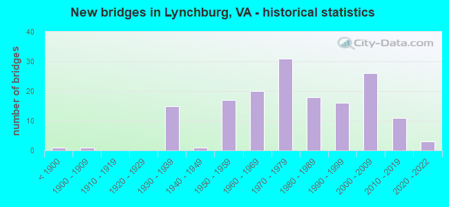
- New bridges - historical statistics
- 1Before 1900
- 11900-1909
- 151930-1939
- 11940-1949
- 171950-1959
- 201960-1969
- 311970-1979
- 181980-1989
- 161990-1999
- 262000-2009
- 112010-2019
- 32020-2022
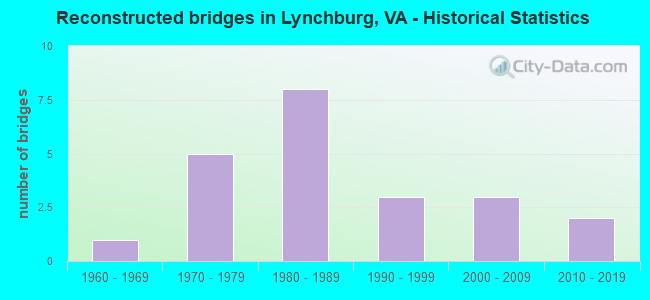
- Reconstructed bridges - Historical Statistics
- 11960-1969
- 51970-1979
- 81980-1989
- 31990-1999
- 32000-2009
- 22010-2019
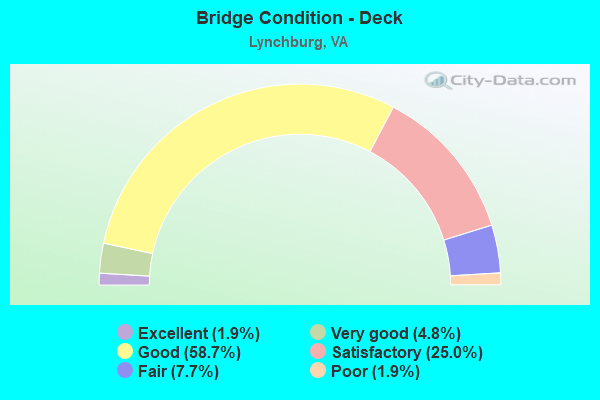
- Bridge Condition - Deck
- 1.9%Excellent
- 4.8%Very good
- 58.7%Good
- 25.0%Satisfactory
- 7.7%Fair
- 1.9%Poor
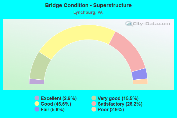
- Bridge Condition - Superstructure
- 2.9%Excellent
- 15.5%Very good
- 46.6%Good
- 26.2%Satisfactory
- 5.8%Fair
- 2.9%Poor
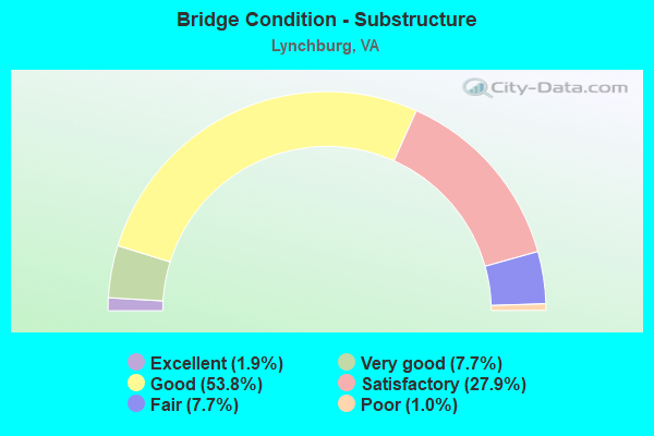
- Bridge Condition - Substructure
- 1.9%Excellent
- 7.7%Very good
- 53.8%Good
- 27.9%Satisfactory
- 7.7%Fair
- 1.0%Poor
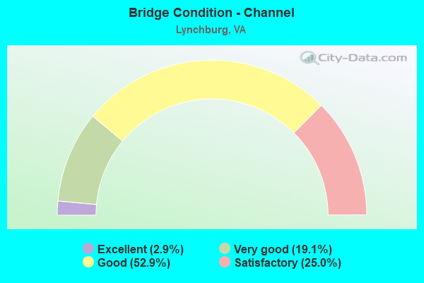
- Bridge Condition - Channel
- 2.9%Excellent
- 19.1%Very good
- 52.9%Good
- 25.0%Satisfactory
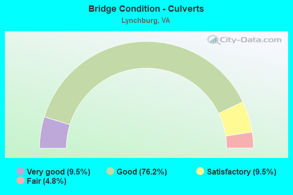
- Bridge Condition - Culverts
- 9.5%Very good
- 76.2%Good
- 9.5%Satisfactory
- 4.8%Fair
Find on map >> Show street view
Structure Number: 1527, Location: 0.30-Rt 684/4.99-Rt 130 (Lat: 37.438914, Lng: -79.150728), Route carried "on" structure: County highway 685, Year Built: 1967, Status: Open, Structure Length: 5.82m (19.09ft), Average Daily Traffic: 420 (year 2020), Truck Traffic: 1%, Average Future Daily Traffic: 462 (year 2040), Design Load: HS 20+Mod, Features Intersected: Harris Creek, Facility Carried by Structure: River Road
Minimum Vertical Clearance: 30+ m (98+ ft), Kilometerpoint: 7.594, Lanes on structure: 2, Owner: State Highway Agency, Approaching Roadway Width: 6.4m (21.0ft), Material/Design: Steel, Design/Construction: Stringer/Multi-beam, Number Of Spans In Main Unit: 3, Length of Maximum Span: 17.7m (58.1ft), Curb or Sidewalk Widths: Left: 0.5m (1.6ft), Right: 0.5m (1.6ft), Curb-To-Curb Width: 8.8m (28.9ft), Out-to-Out Width: 9.7m (31.8ft)
Condition: Deck: Satisfactory, Superstructure: Fair, Substructure: Satisfactory, Channel: Good, Operating Rating: 53.5 metric tons, Method Used To Determine Operating Rating: Load and Resistance Factor (LRFR), Inventory Rating: 40.8 metric tons, Method Used To Determine Inventory Rating: Load and Resistance Factor (LRFR), Structural Evaluation: Somewhat better than minimum adequacy, Deck Geometry: Somewhat better than minimum adequacy, Waterway Adequacy: Better than present minimum criteria, Approach Roadway Alignment: Equal to present minimum criteria, Designated Inspection Frequency: Every 24 months, Inspection Date: January 2021, Deck Structure Type: Concrete Cast-file-Place
Find on map >> Show street view
Structure Number: 2657, Location: 0.60 Rte 647;0.01 Rte 846 (Lat: 37.465528, Lng: -79.264864), Route carried "on" structure: US 501, Year Built: 1931, Status: Open, Structure Length: 1.30m (4.27ft), Average Daily Traffic: 2,488 (year 2020), Truck Traffic: 4%, Average Future Daily Traffic: 2,599 (year 2040), Design Load: H 15, Features Intersected: JUDITH CREEK @ BOONSBORO
Minimum Vertical Clearance: 30+ m (98+ ft), Kilometerpoint: 132.649, Lanes on structure: 3, Base Highway Network: Yes, Owner: State Highway Agency, Approaching Roadway Width: 7.3m (24.0ft), Material/Design: Concrete, Design/Construction: Tee Beam, Number Of Spans In Main Unit: 1, Length of Maximum Span: 12.6m (41.3ft), Curb or Sidewalk Widths: Left: 0.2m (0.7ft), Right: 0.2m (0.7ft), Curb-To-Curb Width: 8.8m (28.9ft), Out-to-Out Width: 9.7m (31.8ft)
Condition: Deck: Satisfactory, Superstructure: Satisfactory, Substructure: Satisfactory, Channel: Satisfactory, Operating Rating: 43.5 metric tons, Method Used To Determine Operating Rating: Load and Resistance Factor (LRFR), Inventory Rating: 33.6 metric tons, Method Used To Determine Inventory Rating: Load and Resistance Factor (LRFR), Structural Evaluation: Equal to present minimum criteria, Deck Geometry: High priority of replacement, Waterway Adequacy: Better than present minimum criteria, Approach Roadway Alignment: Somewhat better than minimum adequacy, Length Of Structure Improvement: 1.98m (6.50ft), Designated Inspection Frequency: Every 24 months, Inspection Date: January 2022, Bridge Improvement Cost: $765,000, Roadway Improvement Cost: $268,000, Total Project Cost: $2,486,000 ( Estimate for 2017), Deck Structure Type: Concrete Cast-file-Place, Wearing Surface/Protective System: Wearing Surface: Latex Concrete
Find on map >> Show street view
Structure Number: 2765, Location: 0.05-LYNCH CL;0.05-RT_794 (Lat: 37.468800, Lng: -79.210078), Route carried "on" structure: County highway 645, Year Built: 1932, Year Reconstructed: 1999, Status: Open, Structure Length: 1.16m (3.81ft), Average Daily Traffic: 423 (year 2020), Truck Traffic: 5%, Average Future Daily Traffic: 588 (year 2040), Features Intersected: Judith Creek
Minimum Vertical Clearance: 30+ m (98+ ft), Kilometerpoint: 10.849, Lanes on structure: 2, Owner: State Highway Agency, Approaching Roadway Width: 5.5m (18.0ft), Skew: 4 degrees, Material/Design: Steel, Design/Construction: Stringer/Multi-beam, Number Of Spans In Main Unit: 1, Length of Maximum Span: 11.6m (38.1ft), Curb or Sidewalk Widths: Left: 0.4m (1.3ft), Right: 0.4m (1.3ft), Curb-To-Curb Width: 5.5m (18.0ft), Out-to-Out Width: 6.3m (20.7ft)
Condition: Deck: Very good, Superstructure: Very good, Substructure: Satisfactory, Channel: Very good, Operating Rating: 81.6 metric tons, Method Used To Determine Operating Rating: Load and Resistance Factor (LRFR), Inventory Rating: 62.6 metric tons, Method Used To Determine Inventory Rating: Load and Resistance Factor (LRFR), Structural Evaluation: Equal to present minimum criteria, Deck Geometry: High priority of replacement, Waterway Adequacy: Equal to present desirable criteria, Approach Roadway Alignment: Equal to present minimum criteria, Designated Inspection Frequency: Every 24 months, Inspection Date: October 2020, Deck Structure Type: Wood or Timber, Wearing Surface/Protective System: Wearing Surface: Bituminous, Membrane: Other
Find on map >> Show street view
Structure Number: 4144, Location: 1.00-Lynch CL/0.71-Rt.683 (Lat: 37.329106, Lng: -79.190986), Route carried "on" structure: US 29, Year Built: 1950, Status: Open, Structure Length: 8.39m (27.53ft), Average Daily Traffic: 14,591 (year 2020), Truck Traffic: 6%, Average Future Daily Traffic: 20,427 (year 2040), Design Load: HS 20, Features Intersected: NS Railway
Minimum Vertical Clearance: 30+ m (98+ ft), Kilometerpoint: 107.948, Lanes on structure: 2, Base Highway Network: Yes, Owner: State Highway Agency, Approaching Roadway Width: 7.9m (25.9ft), Skew: 5 degrees, Material/Design: Steel, Design/Construction: Stringer/Multi-beam, Number Of Spans In Main Unit: 5, Length of Maximum Span: 23.6m (77.4ft), Curb-To-Curb Width: 8.5m (27.9ft), Out-to-Out Width: 9.4m (30.8ft)
Condition: Deck: Fair, Superstructure: Fair, Substructure: Fair, Operating Rating: 39.9 metric tons, Method Used To Determine Operating Rating: Load and Resistance Factor (LRFR), Inventory Rating: 30.8 metric tons, Method Used To Determine Inventory Rating: Load and Resistance Factor (LRFR), Structural Evaluation: Somewhat better than minimum adequacy, Deck Geometry: High priority of corrective action, Approach Roadway Alignment: Equal to present desirable criteria, Length Of Structure Improvement: 9.66m (31.69ft), Designated Inspection Frequency: Every 12 months, Critical Feature Inspection Frequency: Every 12 months, Inspection Date: March 2021, Critical Feature Inspection Date: March 2021, Bridge Improvement Cost: $2,891,000, Roadway Improvement Cost: $289,000, Total Project Cost: $4,337,000 ( Estimate for 2015), Deck Structure Type: Concrete Cast-file-Place, Wearing Surface/Protective System: Wearing Surface: Latex Concrete
Find on map >> Show street view
Structure Number: 4149, Location: 4.06-Rt 24N/2.44-LY. C.L (Lat: 37.309011, Lng: -79.181464), Route carried "on" structure: US 29, Year Built: 1932, Status: Open, Structure Length: 0.64m (2.10ft), Average Daily Traffic: 18,655 (year 2020), Truck Traffic: 7%, Average Future Daily Traffic: 23,620 (year 2040), Design Load: HS 20, Features Intersected: Trib. Flat Creek, Facility Carried by Structure: Wards Road
Minimum Vertical Clearance: 30+ m (98+ ft), Kilometerpoint: 105.534, Lanes on structure: 4, Base Highway Network: Yes, Owner: State Highway Agency, Approaching Roadway Width: 7.9m (25.9ft), Material/Design: Concrete, Design/Construction: Culvert, Number Of Spans In Main Unit: 2, Length of Maximum Span: 3.0m (9.8ft)
Condition: Channel: Satisfactory, Culverts: Fair, Operating Rating: 89.8 metric tons, Method Used To Determine Operating Rating: Load Factor (LF), Inventory Rating: 56.2 metric tons, Method Used To Determine Inventory Rating: Load Factor (LF), Structural Evaluation: Somewhat better than minimum adequacy, Waterway Adequacy: Better than present minimum criteria, Approach Roadway Alignment: Equal to present desirable criteria, Length Of Structure Improvement: 0.64m (2.10ft), Designated Inspection Frequency: Every 24 months, Inspection Date: May 2021, Bridge Improvement Cost: $524,000, Roadway Improvement Cost: $52,000, Total Project Cost: $786,000 ( Estimate for 2015)
Find on map >> Show street view
Structure Number: 4151, Location: 0.71-Rt.683/1.00-Lynch CL (Lat: 37.328769, Lng: -79.191072), Route carried "on" structure: US 29, Year Built: 1967, Status: Open, Structure Length: 10.00m (32.81ft), Average Daily Traffic: 14,591 (year 2020), Truck Traffic: 7%, Average Future Daily Traffic: 20,427 (year 2040), Design Load: HS 20+Mod, Features Intersected: NS Railway
Minimum Vertical Clearance: 30+ m (98+ ft), Kilometerpoint: 107.932, Lanes on structure: 2, Base Highway Network: Yes, Owner: State Highway Agency, Approaching Roadway Width: 7.3m (24.0ft), Skew: 5 degrees, Material/Design: Steel, Design/Construction: Stringer/Multi-beam, Number Of Spans In Main Unit: 5, Length of Maximum Span: 23.8m (78.1ft), Curb or Sidewalk Widths: Left: 0.5m (1.6ft), Right: 1.5m (4.9ft), Curb-To-Curb Width: 8.5m (27.9ft), Out-to-Out Width: 11.1m (36.4ft)
Condition: Deck: Satisfactory, Superstructure: Satisfactory, Substructure: Satisfactory, Operating Rating: 98.0 metric tons, Method Used To Determine Operating Rating: Load and Resistance Factor (LRFR), Inventory Rating: 75.3 metric tons, Method Used To Determine Inventory Rating: Load and Resistance Factor (LRFR), Structural Evaluation: Equal to present minimum criteria, Deck Geometry: High priority of corrective action, Approach Roadway Alignment: Meets minimum limits, Length Of Structure Improvement: 11.89m (39.01ft), Designated Inspection Frequency: Every 24 months, Inspection Date: March 2020, Bridge Improvement Cost: $3,409,000, Roadway Improvement Cost: $341,000, Total Project Cost: $5,114,000 ( Estimate for 2014), Deck Structure Type: Concrete Cast-file-Place, Wearing Surface/Protective System: Wearing Surface: Latex Concrete
Find on map >> Show street view
Structure Number: 417, Location: 0.50-Rt.726/0.85-Rt.662 (Lat: 37.385169, Lng: -79.054797), Route carried "on" structure: US 460, Year Built: 1939, Status: Open, Structure Length: 3.43m (11.25ft), Average Daily Traffic: 10,506 (year 2020), Truck Traffic: 7%, Average Future Daily Traffic: 14,708 (year 2040), Features Intersected: Beaver Creek
Minimum Vertical Clearance: 30+ m (98+ ft), Kilometerpoint: 339.095, Lanes on structure: 2, Base Highway Network: Yes, Owner: State Highway Agency, Approaching Roadway Width: 7.3m (24.0ft), Skew: 3 degrees, Material/Design: Concrete, Design/Construction: Tee Beam, Number Of Spans In Main Unit: 3, Length of Maximum Span: 11.4m (37.4ft), Curb-To-Curb Width: 10.7m (35.1ft), Out-to-Out Width: 11.0m (36.1ft)
Condition: Deck: Fair, Superstructure: Satisfactory, Substructure: Satisfactory, Channel: Satisfactory, Operating Rating: 43.5 metric tons, Method Used To Determine Operating Rating: Load and Resistance Factor (LRFR), Inventory Rating: 33.6 metric tons, Method Used To Determine Inventory Rating: Load and Resistance Factor (LRFR), Structural Evaluation: Equal to present minimum criteria, Deck Geometry: Somewhat better than minimum adequacy, Waterway Adequacy: Better than present minimum criteria, Approach Roadway Alignment: Meets minimum limits, Designated Inspection Frequency: Every 24 months, Inspection Date: July 2021, Deck Structure Type: Concrete Cast-file-Place, Wearing Surface/Protective System: Wearing Surface: Latex Concrete, Deck Protection: Other
Find on map >> Show street view
Structure Number: 4171, Location: 3.54-Rt501/6.29-Rt24 (Lat: 37.386372, Lng: -79.073861), Route carried "on" structure: US 460, Year Built: 1983, Status: Open, Structure Length: 4.19m (13.75ft), Average Daily Traffic: 12,337 (year 2020), Truck Traffic: 7%, Average Future Daily Traffic: 17,273 (year 2040), Features Intersected: Opossum Creek
Minimum Vertical Clearance: 30+ m (98+ ft), Kilometerpoint: 337.351, Lanes on structure: 2, Base Highway Network: Yes, Owner: State Highway Agency, Approaching Roadway Width: 9.1m (29.9ft), Skew: 1 degrees, Material/Design: Steel, Design/Construction: Stringer/Multi-beam, Number Of Spans In Main Unit: 3, Length of Maximum Span: 13.8m (45.3ft), Curb-To-Curb Width: 11.6m (38.1ft), Out-to-Out Width: 12.7m (41.7ft)
Condition: Deck: Good, Superstructure: Good, Substructure: Satisfactory, Channel: Satisfactory, Operating Rating: 73.5 metric tons, Method Used To Determine Operating Rating: Load and Resistance Factor (LRFR), Inventory Rating: 56.2 metric tons, Method Used To Determine Inventory Rating: Load and Resistance Factor (LRFR), Structural Evaluation: Equal to present minimum criteria, Deck Geometry: Better than present minimum criteria, Waterway Adequacy: Better than present minimum criteria, Approach Roadway Alignment: Equal to present desirable criteria, Designated Inspection Frequency: Every 24 months, Inspection Date: January 2022, Deck Structure Type: Concrete Cast-file-Place, Wearing Surface/Protective System: Deck Protection: Epoxy Coated Reinforcing
Find on map >> Show street view
Structure Number: 4173, Location: 0.85-Lynch CL/6.29-Rt 24 (Lat: 37.386217, Lng: -79.073911), Route carried "on" structure: US 460, Year Built: 1956, Status: Open, Structure Length: 3.51m (11.52ft), Average Daily Traffic: 12,337 (year 2020), Truck Traffic: 7%, Average Future Daily Traffic: 17,273 (year 2040), Design Load: H 15, Features Intersected: Opossum Creek, Facility Carried by Structure: Richmond Highway
Minimum Vertical Clearance: 30+ m (98+ ft), Kilometerpoint: 337.357, Lanes on structure: 2, Base Highway Network: Yes, Owner: State Highway Agency, Approaching Roadway Width: 8.5m (27.9ft), Material/Design: Concrete, Design/Construction: Tee Beam, Number Of Spans In Main Unit: 3, Length of Maximum Span: 11.9m (39.0ft), Curb or Sidewalk Widths: Left: 0.5m (1.6ft), Right: 0.5m (1.6ft), Curb-To-Curb Width: 8.5m (27.9ft), Out-to-Out Width: 9.4m (30.8ft)
Condition: Deck: Satisfactory, Superstructure: Satisfactory, Substructure: Satisfactory, Channel: Satisfactory, Operating Rating: 47.2 metric tons, Method Used To Determine Operating Rating: Load and Resistance Factor (LRFR), Inventory Rating: 36.3 metric tons, Method Used To Determine Inventory Rating: Load and Resistance Factor (LRFR), Structural Evaluation: Equal to present minimum criteria, Deck Geometry: High priority of corrective action, Waterway Adequacy: Equal to present minimum criteria, Approach Roadway Alignment: Equal to present desirable criteria, Length Of Structure Improvement: 4.57m (14.99ft), Designated Inspection Frequency: Every 24 months, Inspection Date: July 2020, Bridge Improvement Cost: $1,311,000, Roadway Improvement Cost: $131,000, Total Project Cost: $1,967,000 ( Estimate for 2014), Deck Structure Type: Concrete Cast-file-Place, Wearing Surface/Protective System: Wearing Surface: Latex Concrete
Find on map >> Show street view
Structure Number: 4174, Location: .60-Rt726 / 2.2-Rt662 (Lat: 37.385342, Lng: -79.054756), Route carried "on" structure: US 460, Year Built: 1956, Status: Open, Structure Length: 3.50m (11.48ft), Average Daily Traffic: 10,506 (year 2020), Truck Traffic: 6%, Average Future Daily Traffic: 14,708 (year 2040), Features Intersected: Beaver Creek
Minimum Vertical Clearance: 30+ m (98+ ft), Kilometerpoint: 339.095, Lanes on structure: 2, Base Highway Network: Yes, Owner: State Highway Agency, Approaching Roadway Width: 7.9m (25.9ft), Skew: 3 degrees, Material/Design: Concrete, Design/Construction: Tee Beam, Number Of Spans In Main Unit: 3, Length of Maximum Span: 11.4m (37.4ft), Curb or Sidewalk Widths: Left: 0.5m (1.6ft), Right: 0.5m (1.6ft), Curb-To-Curb Width: 8.5m (27.9ft), Out-to-Out Width: 10.1m (33.1ft)
Condition: Deck: Fair, Superstructure: Satisfactory, Substructure: Fair, Channel: Good, Operating Rating: 46.3 metric tons, Method Used To Determine Operating Rating: Load and Resistance Factor (LRFR), Inventory Rating: 35.4 metric tons, Method Used To Determine Inventory Rating: Load and Resistance Factor (LRFR), Structural Evaluation: Somewhat better than minimum adequacy, Deck Geometry: High priority of corrective action, Waterway Adequacy: Better than present minimum criteria, Approach Roadway Alignment: Equal to present minimum criteria, Length Of Structure Improvement: 4.21m (13.81ft), Designated Inspection Frequency: Every 24 months, Inspection Date: November 2021, Bridge Improvement Cost: $699,000, Roadway Improvement Cost: $70,000, Total Project Cost: $1,049,000 ( Estimate for 2015), Deck Structure Type: Concrete Cast-file-Place, Wearing Surface/Protective System: Wearing Surface: Latex Concrete
Find on map >> Show street view
Structure Number: 4177, Location: .41-Rt 29/.26 Lynch CL (Lat: 37.340547, Lng: -79.188681), Route carried "on" structure: US 29, Year Built: 1979, Year Reconstructed: 1999, Status: Open, Structure Length: 5.06m (16.60ft), Average Daily Traffic: 19,666 (year 2020), Truck Traffic: 7%, Average Future Daily Traffic: 27,532 (year 2040), Features Intersected: NS Railway
Minimum Vertical Clearance: 30+ m (98+ ft), Kilometerpoint: 325.131, Lanes on structure: 3, Base Highway Network: Yes, Owner: State Highway Agency, Approaching Roadway Width: 15.2m (49.9ft), Skew: 2 degrees, Material/Design: Steel continuous, Design/Construction: Stringer/Multi-beam, Number Of Spans In Main Unit: 3, Length of Maximum Span: 21.4m (70.2ft), Curb-To-Curb Width: 15.5m (50.9ft), Out-to-Out Width: 16.5m (54.1ft)
Condition: Deck: Good, Superstructure: Satisfactory, Substructure: Good, Operating Rating: 83.5 metric tons, Method Used To Determine Operating Rating: Load and Resistance Factor (LRFR), Inventory Rating: 64.4 metric tons, Method Used To Determine Inventory Rating: Load and Resistance Factor (LRFR), Structural Evaluation: Equal to present minimum criteria, Deck Geometry: Somewhat better than minimum adequacy, Approach Roadway Alignment: Better than present minimum criteria, Designated Inspection Frequency: Every 24 months, Inspection Date: January 2020, Deck Structure Type: Concrete Cast-file-Place, Wearing Surface/Protective System: Wearing Surface: Latex Concrete, Deck Protection: Epoxy Coated Reinforcing
Find on map >> Show street view
Structure Number: 4178, Location: .41 Rt 29/.26 Lynch CL (Lat: 37.340214, Lng: -79.188781), Route carried "on" structure: US 29, Year Built: 1979, Status: Open, Structure Length: 5.06m (16.60ft), Average Daily Traffic: 19,666 (year 2020), Truck Traffic: 7%, Average Future Daily Traffic: 27,532 (year 2040), Features Intersected: NS Railway
Minimum Vertical Clearance: 30+ m (98+ ft), Kilometerpoint: 325.131, Lanes on structure: 3, Base Highway Network: Yes, Owner: State Highway Agency, Approaching Roadway Width: 12.2m (40.0ft), Skew: 2 degrees, Material/Design: Steel, Design/Construction: Stringer/Multi-beam, Number Of Spans In Main Unit: 3, Length of Maximum Span: 21.3m (69.9ft), Curb-To-Curb Width: 15.4m (50.5ft), Out-to-Out Width: 16.5m (54.1ft)
Condition: Deck: Good, Superstructure: Satisfactory, Substructure: Satisfactory, Operating Rating: 89.8 metric tons, Method Used To Determine Operating Rating: Load and Resistance Factor (LRFR), Inventory Rating: 72.6 metric tons, Method Used To Determine Inventory Rating: Load and Resistance Factor (LRFR), Structural Evaluation: Equal to present minimum criteria, Deck Geometry: Somewhat better than minimum adequacy, Approach Roadway Alignment: Better than present minimum criteria, Designated Inspection Frequency: Every 24 months, Inspection Date: January 2020, Deck Structure Type: Concrete Cast-file-Place, Wearing Surface/Protective System: Wearing Surface: Latex Concrete, Deck Protection: Epoxy Coated Reinforcing
Find on map >> Show street view
Structure Number: 4179, Location: 0.28-Rt 29/0.37 Lynch WCL (Lat: 37.340353, Lng: -79.191114), Route carried "on" structure: State highway 29, Year Built: 1979, Status: Open, Structure Length: 5.43m (17.81ft), Average Daily Traffic: 19,666 (year 2020), Truck Traffic: 7%, Average Future Daily Traffic: 27,532 (year 2040), Features Intersected: 29 Business
Minimum Vertical Clearance: 30+ m (98+ ft), Kilometerpoint: 324.921, Lanes on structure: 2, Lanes under structure: 6, Base Highway Network: Yes, Owner: State Highway Agency, Approaching Roadway Width: 12.8m (42.0ft), Skew: 1 degrees, Material/Design: Steel, Design/Construction: Stringer/Multi-beam, Number Of Spans In Main Unit: 3, Length of Maximum Span: 33.5m (109.9ft), Curb-To-Curb Width: 15.5m (50.9ft), Out-to-Out Width: 16.5m (54.1ft)
Condition: Deck: Satisfactory, Superstructure: Satisfactory, Substructure: Good, Operating Rating: 44.5 metric tons, Method Used To Determine Operating Rating: Load and Resistance Factor (LRFR), Inventory Rating: 34.5 metric tons, Method Used To Determine Inventory Rating: Load and Resistance Factor (LRFR), Structural Evaluation: Equal to present minimum criteria, Deck Geometry: Superior to present desirable criteria, Underclear: Meets minimum limits, Approach Roadway Alignment: Equal to present desirable criteria, Designated Inspection Frequency: Every 24 months, Inspection Date: May 2020, Deck Structure Type: Concrete Cast-file-Place, Wearing Surface/Protective System: Wearing Surface: Latex Concrete, Deck Protection: Epoxy Coated Reinforcing
Find on map >> Show street view
Structure Number: 4181, Location: 0.28-Rt 29/0.37 Lynch WCL (Lat: 37.340103, Lng: -79.191167), Route carried "on" structure: State highway 29, Year Built: 1979, Status: Open, Structure Length: 5.43m (17.81ft), Average Daily Traffic: 19,666 (year 2020), Truck Traffic: 7%, Average Future Daily Traffic: 27,532 (year 2040), Features Intersected: 29 Business
Minimum Vertical Clearance: 30+ m (98+ ft), Kilometerpoint: 324.921, Lanes on structure: 3, Lanes under structure: 6, Base Highway Network: Yes, Owner: State Highway Agency, Approaching Roadway Width: 12.8m (42.0ft), Skew: 1 degrees, Material/Design: Steel, Design/Construction: Stringer/Multi-beam, Number Of Spans In Main Unit: 3, Length of Maximum Span: 33.8m (110.9ft), Curb-To-Curb Width: 15.5m (50.9ft), Out-to-Out Width: 16.4m (53.8ft)
Condition: Deck: Satisfactory, Superstructure: Satisfactory, Substructure: Good, Operating Rating: 43.5 metric tons, Method Used To Determine Operating Rating: Load and Resistance Factor (LRFR), Inventory Rating: 33.6 metric tons, Method Used To Determine Inventory Rating: Load and Resistance Factor (LRFR), Structural Evaluation: Equal to present minimum criteria, Deck Geometry: Somewhat better than minimum adequacy, Underclear: Somewhat better than minimum adequacy, Approach Roadway Alignment: Equal to present desirable criteria, Designated Inspection Frequency: Every 24 months, Inspection Date: May 2020, Deck Structure Type: Concrete Cast-file-Place, Wearing Surface/Protective System: Wearing Surface: Latex Concrete, Membrane: Other, Deck Protection: Epoxy Coated Reinforcing
Find on map >> Show street view
Structure Number: 4191, Location: 1.87-Lynch CL/0.01-Rt 667 (Lat: 37.345244, Lng: -79.107292), Route carried "on" structure: US 501, Year Built: 1990, Status: Open, Structure Length: 3.17m (10.40ft), Average Daily Traffic: 3,979 (year 2020), Truck Traffic: 3%, Average Future Daily Traffic: 5,572 (year 2040), Features Intersected: Opossum Creek, Facility Carried by Structure: NBL Campbell Hwy.
Minimum Vertical Clearance: 30+ m (98+ ft), Kilometerpoint: 105.566, Lanes on structure: 2, Owner: State Highway Agency, Approaching Roadway Width: 11.0m (36.1ft), Material/Design: Steel, Design/Construction: Stringer/Multi-beam, Number Of Spans In Main Unit: 1, Length of Maximum Span: 29.9m (98.1ft), Curb or Sidewalk Widths: Left: 0.5m (1.6ft), Right: 0.5m (1.6ft), Curb-To-Curb Width: 12.8m (42.0ft), Out-to-Out Width: 13.8m (45.3ft)
Condition: Deck: Satisfactory, Superstructure: Good, Substructure: Good, Channel: Good, Operating Rating: 53.5 metric tons, Method Used To Determine Operating Rating: Load and Resistance Factor (LRFR), Inventory Rating: 41.7 metric tons, Method Used To Determine Inventory Rating: Load and Resistance Factor (LRFR), Structural Evaluation: Better than present minimum criteria, Deck Geometry: Equal to present desirable criteria, Waterway Adequacy: Equal to present desirable criteria, Approach Roadway Alignment: Equal to present desirable criteria, Designated Inspection Frequency: Every 24 months, Inspection Date: December 2020, Deck Structure Type: Concrete Cast-file-Place, Wearing Surface/Protective System: Deck Protection: Epoxy Coated Reinforcing
Find on map >> Show street view
Structure Number: 4192, Location: 1.87-Lynch CL/0.01-Rt 667 (Lat: 37.345319, Lng: -79.107550), Route carried "on" structure: US 501, Year Built: 1991, Status: Open, Structure Length: 3.17m (10.40ft), Average Daily Traffic: 3,979 (year 2020), Truck Traffic: 3%, Average Future Daily Traffic: 5,572 (year 2040), Features Intersected: Opossum Creek, Facility Carried by Structure: SBL Campbell Hwy.
Minimum Vertical Clearance: 30+ m (98+ ft), Kilometerpoint: 109.703, Lanes on structure: 3, Base Highway Network: Yes, Owner: State Highway Agency, Approaching Roadway Width: 7.9m (25.9ft), Material/Design: Steel, Design/Construction: Stringer/Multi-beam, Number Of Spans In Main Unit: 1, Length of Maximum Span: 29.8m (97.8ft), Curb-To-Curb Width: 16.5m (54.1ft), Out-to-Out Width: 17.5m (57.4ft)
Condition: Deck: Satisfactory, Superstructure: Good, Substructure: Good, Channel: Good, Operating Rating: 51.7 metric tons, Method Used To Determine Operating Rating: Load and Resistance Factor (LRFR), Inventory Rating: 39.9 metric tons, Method Used To Determine Inventory Rating: Load and Resistance Factor (LRFR), Structural Evaluation: Better than present minimum criteria, Deck Geometry: Better than present minimum criteria, Waterway Adequacy: Equal to present desirable criteria, Approach Roadway Alignment: Equal to present desirable criteria, Designated Inspection Frequency: Every 24 months, Inspection Date: December 2020, Deck Structure Type: Concrete Cast-file-Place, Wearing Surface/Protective System: Deck Protection: Epoxy Coated Reinforcing
Find on map >> Show street view
Structure Number: 4288, Location: 1.60-Rt 664/1.48-Rt 1480 (Lat: 37.345739, Lng: -79.141331), Route carried "on" structure: County highway 677, Year Built: 1957, Year Reconstructed: 2016, Status: Open, Structure Length: 0.72m (2.36ft), Average Daily Traffic: 354 (year 2020), Truck Traffic: 3%, Average Future Daily Traffic: 375 (year 2040), Design Load: HL 93, Features Intersected: Opossum Creek, Facility Carried by Structure: Camp Hydaway Road
Minimum Vertical Clearance: 30+ m (98+ ft), Kilometerpoint: 5.599, Lanes on structure: 2, Owner: State Highway Agency, Approaching Roadway Width: 4.9m (16.1ft), Material/Design: Prestressed concrete, Design/Construction: Slab, Number Of Spans In Main Unit: 1, Length of Maximum Span: 6.6m (21.7ft), Curb or Sidewalk Widths: Left: 0.3m (1.0ft), Right: 0.3m (1.0ft), Curb-To-Curb Width: 6.8m (22.3ft), Out-to-Out Width: 7.3m (24.0ft)
Condition: Deck: Very good, Superstructure: Very good, Substructure: Good, Channel: Good, Operating Rating: 68.9 metric tons, Method Used To Determine Operating Rating: Load and Resistance Factor (LRFR), Inventory Rating: 52.6 metric tons, Method Used To Determine Inventory Rating: Load and Resistance Factor (LRFR), Structural Evaluation: Better than present minimum criteria, Deck Geometry: Meets minimum limits, Waterway Adequacy: Somewhat better than minimum adequacy, Approach Roadway Alignment: Equal to present desirable criteria, Length Of Structure Improvement: 1.34m (4.40ft), Designated Inspection Frequency: Every 24 months, Inspection Date: October 2020, Bridge Improvement Cost: $234,000, Roadway Improvement Cost: $23,000, Total Project Cost: $351,000 ( Estimate for 2015), Deck Structure Type: Concrete Precast Panels, Wearing Surface/Protective System: Wearing Surface: Bituminous
Find on map >> Show street view
Structure Number: 4289, Location: 0.37-Rt.682 / 0.11-Rt.885 (Lat: 37.331522, Lng: -79.208853), Route carried "on" structure: County highway 678, Year Built: 1987, Status: Open, Structure Length: 6.89m (22.60ft), Average Daily Traffic: 2,547 (year 2020), Truck Traffic: 4%, Average Future Daily Traffic: 3,566 (year 2040), Design Load: HS 20+Mod, Features Intersected: Route 460 Bypass, Facility Carried by Structure: Greenview Drive
Minimum Vertical Clearance: 30+ m (98+ ft), Kilometerpoint: 0.595, Lanes on structure: 4, Lanes under structure: 4, Owner: State Highway Agency, Approaching Roadway Width: 24.4m (80.1ft), Skew: 20 degrees, Material/Design: Steel continuous, Design/Construction: Stringer/Multi-beam, Number Of Spans In Main Unit: 2, Length of Maximum Span: 34.1m (111.9ft), Curb-To-Curb Width: 23.8m (78.1ft), Out-to-Out Width: 24.8m (81.4ft)
Condition: Deck: Good, Superstructure: Good, Substructure: Satisfactory, Operating Rating: 93.4 metric tons, Method Used To Determine Operating Rating: Load and Resistance Factor (LRFR), Inventory Rating: 71.7 metric tons, Method Used To Determine Inventory Rating: Load and Resistance Factor (LRFR), Structural Evaluation: Equal to present minimum criteria, Deck Geometry: Superior to present desirable criteria, Underclear: Superior to present desirable criteria, Approach Roadway Alignment: Equal to present desirable criteria, Designated Inspection Frequency: Every 24 months, Inspection Date: July 2021, Deck Structure Type: Concrete Cast-file-Place, Wearing Surface/Protective System: Wearing Surface: Epoxy Overlay, Deck Protection: Epoxy Coated Reinforcing
Find on map >> Show street view
Structure Number: 434, Location: 0.05-Rt 609/2.03-ESMaint (Lat: 37.390733, Lng: -79.059775), Route carried "on" structure: County highway 726, Year Built: 1957, Status: Open, Structure Length: 4.56m (14.96ft), Average Daily Traffic: 5,144 (year 2020), Truck Traffic: 2%, Average Future Daily Traffic: 5,658 (year 2040), Design Load: HS 15, Features Intersected: Beaver Creek, Facility Carried by Structure: Mount Athos Road
Minimum Vertical Clearance: 30+ m (98+ ft), Kilometerpoint: 0.628, Lanes on structure: 2, Owner: State Highway Agency, Approaching Roadway Width: 7.3m (24.0ft), Material/Design: Steel, Design/Construction: Stringer/Multi-beam, Number Of Spans In Main Unit: 3, Length of Maximum Span: 19.1m (62.7ft), Curb or Sidewalk Widths: Left: 0.5m (1.6ft), Right: 0.5m (1.6ft), Curb-To-Curb Width: 7.9m (25.9ft), Out-to-Out Width: 8.9m (29.2ft)
Condition: Deck: Fair, Superstructure: Good, Substructure: Fair, Channel: Very good, Operating Rating: 71.7 metric tons, Method Used To Determine Operating Rating: Load and Resistance Factor (LRFR), Inventory Rating: 55.3 metric tons, Method Used To Determine Inventory Rating: Load and Resistance Factor (LRFR), Structural Evaluation: Somewhat better than minimum adequacy, Deck Geometry: High priority of replacement, Waterway Adequacy: Better than present minimum criteria, Approach Roadway Alignment: Equal to present minimum criteria, Length Of Structure Improvement: 5.49m (18.01ft), Designated Inspection Frequency: Every 24 months, Inspection Date: July 2020, Bridge Improvement Cost: $958,000, Roadway Improvement Cost: $96,000, Total Project Cost: $1,436,000 ( Estimate for 2014), Deck Structure Type: Concrete Cast-file-Place, Wearing Surface/Protective System: Wearing Surface: Latex Concrete
Find on map >> Show street view
Structure Number: 4342, Location: 0.22-Rt 460/0.35-Rt 609 (Lat: 37.385736, Lng: -79.062917), Route carried "on" structure: County highway 726, Year Built: 1976, Status: Open, Structure Length: 5.96m (19.55ft), Average Daily Traffic: 6,348 (year 2020), Truck Traffic: 2%, Average Future Daily Traffic: 6,472 (year 2040), Design Load: HS 20+Mod, Features Intersected: Route 460, Facility Carried by Structure: Mt. Athos Road
Minimum Vertical Clearance: 30+ m (98+ ft), Kilometerpoint: 0.354, Lanes on structure: 2, Lanes under structure: 4, Owner: State Highway Agency, Approaching Roadway Width: 8.5m (27.9ft), Skew: 1 degrees, Material/Design: Steel, Design/Construction: Stringer/Multi-beam, Number Of Spans In Main Unit: 3, Length of Maximum Span: 42.6m (139.8ft), Curb-To-Curb Width: 10.4m (34.1ft), Out-to-Out Width: 11.6m (38.1ft)
Condition: Deck: Satisfactory, Superstructure: Good, Substructure: Satisfactory, Operating Rating: 71.7 metric tons, Method Used To Determine Operating Rating: Load and Resistance Factor (LRFR), Inventory Rating: 55.3 metric tons, Method Used To Determine Inventory Rating: Load and Resistance Factor (LRFR), Structural Evaluation: Equal to present minimum criteria, Deck Geometry: Meets minimum limits, Underclear: Equal to present minimum criteria, Approach Roadway Alignment: Equal to present minimum criteria, Designated Inspection Frequency: Every 24 months, Inspection Date: January 2022, Deck Structure Type: Concrete Cast-file-Place, Wearing Surface/Protective System: Wearing Surface: Epoxy Overlay, Membrane: Epoxy
Find on map >> Show street view
Structure Number: 20486, Location: 0.01-Rt.F907 / 0.01-LU (Lat: 37.352183, Lng: -79.173917), Route carried "on" structure: ServiceCity street F906, Year Built: 1979, Status: Open, Structure Length: 8.44m (27.69ft), Average Daily Traffic: 4,900 (year 2016), Average Future Daily Traffic: 7,350 (year 2035), Design Load: HS 20+Mod, Features Intersected: Route 29 & 460, Facility Carried by Structure: Liberty Univ. Dr.
Minimum Vertical Clearance: 30+ m (98+ ft), Kilometerpoint: 0.064, Lanes on structure: 2, Lanes under structure: 4, Owner: State Highway Agency, Approaching Roadway Width: 8.5m (27.9ft), Material/Design: Steel continuous, Design/Construction: Stringer/Multi-beam, Number Of Spans In Main Unit: 2, Length of Maximum Span: 42.1m (138.1ft), Curb-To-Curb Width: 8.5m (27.9ft), Out-to-Out Width: 8.6m (28.2ft)
Condition: Deck: Satisfactory, Superstructure: Good, Substructure: Good, Operating Rating: 95.3 metric tons, Method Used To Determine Operating Rating: Load and Resistance Factor (LRFR), Inventory Rating: 73.5 metric tons, Method Used To Determine Inventory Rating: Load and Resistance Factor (LRFR), Structural Evaluation: Better than present minimum criteria, Deck Geometry: Meets minimum limits, Underclear: Equal to present minimum criteria, Approach Roadway Alignment: Better than present minimum criteria, Length Of Structure Improvement: 9.54m (31.30ft), Designated Inspection Frequency: Every 24 months, Inspection Date: January 2022, Bridge Improvement Cost: $1,427,000, Roadway Improvement Cost: $143,000, Total Project Cost: $2,141,000 ( Estimate for 2014), Deck Structure Type: Concrete Cast-file-Place, Wearing Surface/Protective System: Wearing Surface: Monolithic Concrete, Deck Protection: Epoxy Coated Reinforcing
Find on map >> Show street view
Structure Number: 20488, Location: .89 RT 501 / .84 RT 29 B (Lat: 37.425322, Lng: -79.159542), Route carried "on" structure: City street , Year Built: 1930, Year Reconstructed: 1984, Status: Posted for load, Structure Length: 3.32m (10.89ft), Average Daily Traffic: 3,276 (year 2020), Truck Traffic: 4%, Average Future Daily Traffic: 3,618 (year 2040), Features Intersected: Blackwater Creek, Facility Carried by Structure: Hollins Mill Road
Minimum Vertical Clearance: 30+ m (98+ ft), Kilometerpoint: 0.000, Lanes on structure: 2, Owner: City or Municipal Highway Agency, Approaching Roadway Width: 8.5m (27.9ft), Material/Design: Concrete, Design/Construction: Tee Beam, Number Of Spans In Main Unit: 3, Length of Maximum Span: 11.2m (36.7ft), Curb-To-Curb Width: 7.3m (24.0ft), Out-to-Out Width: 8.3m (27.2ft)
Condition: Deck: Good, Superstructure: Satisfactory, Substructure: Satisfactory, Channel: Good, Operating Rating: 22.7 metric tons, Method Used To Determine Operating Rating: Load Factor (LF), Inventory Rating: 12.7 metric tons, Method Used To Determine Inventory Rating: Load Factor (LF), Structural Evaluation: Meets minimum limits, Deck Geometry: High priority of replacement, Waterway Adequacy: Somewhat better than minimum adequacy, Approach Roadway Alignment: Better than present minimum criteria, Bridge Posting: Required (Relationship of Operating Rating to Maximum Legal Load: 10.0 - 19.9% below), Length Of Structure Improvement: 4.15m (13.62ft), Designated Inspection Frequency: Every 12 months, Inspection Date: January 2021, Bridge Improvement Cost: $620,000, Roadway Improvement Cost: $62,000, Total Project Cost: $930,000 ( Estimate for 2015), Deck Structure Type: Concrete Cast-file-Place, Wearing Surface/Protective System: Wearing Surface: Latex Concrete
Find on map >> Show street view
Structure Number: 20489, Location: 0000FORT AVE 0010BUCHANAN (Lat: 37.405314, Lng: -79.156678), Route carried "on" structure: US , Year Built: 1932, Status: Open, Structure Length: 0.91m (2.99ft), Average Daily Traffic: 5,790 (year 2020), Truck Traffic: 1%, Average Future Daily Traffic: 6,369 (year 2040), Features Intersected: NS Railway, Facility Carried by Structure: Park Avenue
Minimum Vertical Clearance: 30+ m (98+ ft), Kilometerpoint: 0.740, Lanes on structure: 3, Owner: Railroad, Approaching Roadway Width: 13.1m (43.0ft), Skew: 3 degrees, Material/Design: Concrete, Design/Construction: Arch - Deck, Number Of Spans In Main Unit: 1, Length of Maximum Span: 9.1m (29.9ft), Curb or Sidewalk Widths: Left: 0.2m (0.7ft), Right: 0.2m (0.7ft), Curb-To-Curb Width: 10.1m (33.1ft), Out-to-Out Width: 16.5m (54.1ft)
Condition: Deck: Satisfactory, Substructure: Satisfactory, Operating Rating: 89.8 metric tons, Method Used To Determine Operating Rating: Field evaluation and documented engineering judgment, Inventory Rating: 89.8 metric tons, Method Used To Determine Inventory Rating: Allowable Stress (AS), Structural Evaluation: Equal to present minimum criteria, Deck Geometry: High priority of replacement, Underclear: High priority of replacement, Approach Roadway Alignment: Equal to present minimum criteria, Length Of Structure Improvement: 1.55m (5.09ft), Designated Inspection Frequency: Every 24 months, Inspection Date: July 2021, Bridge Improvement Cost: $157,000, Roadway Improvement Cost: $16,000, Total Project Cost: $236,000, Deck Structure Type: Concrete Cast-file-Place, Wearing Surface/Protective System: Wearing Surface: Bituminous
Find on map >> Show street view
Structure Number: 2049, Location: .33 12TH ST/.13 1128 (Lat: 37.398625, Lng: -79.153711), Route carried "on" structure: City street , Year Built: 1959, Status: Open, Structure Length: 2.31m (7.58ft), Average Daily Traffic: 9,050 (year 2020), Truck Traffic: 1%, Average Future Daily Traffic: 11,834 (year 2040), Design Load: HS 15, Features Intersected: Lynchburg Expressway, Facility Carried by Structure: Campbell Avenue
Minimum Vertical Clearance: 30+ m (98+ ft), Kilometerpoint: 10.265, Lanes on structure: 2, Lanes under structure: 4, Owner: City or Municipal Highway Agency, Approaching Roadway Width: 11.0m (36.1ft), Skew: 2 degrees, Material/Design: Steel, Design/Construction: Stringer/Multi-beam, Number Of Spans In Main Unit: 1, Length of Maximum Span: 23.1m (75.8ft), Curb or Sidewalk Widths: Left: 0.5m (1.6ft), Right: 1.5m (4.9ft), Curb-To-Curb Width: 11.0m (36.1ft), Out-to-Out Width: 13.6m (44.6ft)
Condition: Deck: Good, Superstructure: Fair, Substructure: Good, Operating Rating: 40.8 metric tons, Method Used To Determine Operating Rating: Load and Resistance Factor (LRFR), Inventory Rating: 30.8 metric tons, Method Used To Determine Inventory Rating: Load and Resistance Factor (LRFR), Structural Evaluation: Somewhat better than minimum adequacy, Deck Geometry: Meets minimum limits, Underclear: High priority of corrective action, Approach Roadway Alignment: Better than present minimum criteria, Length Of Structure Improvement: 3.02m (9.91ft), Designated Inspection Frequency: Every 24 months, Inspection Date: April 2021, Bridge Improvement Cost: $501,000, Roadway Improvement Cost: $51,000, Total Project Cost: $752,000 ( Estimate for 2015), Deck Structure Type: Concrete Cast-file-Place, Wearing Surface/Protective System: Wearing Surface: Latex Concrete
Find on map >> Show street view
Structure Number: 20498, Location: 000029 EXP 0029128 (Lat: 37.386061, Lng: -79.167361), Route carried "on" structure: City street , Year Built: 1961, Year Reconstructed: 1992, Status: Open, Structure Length: 7.25m (23.79ft), Average Daily Traffic: 7,200 (year 2019), Truck Traffic: 12%, Average Future Daily Traffic: 8,500 (year 2040), Design Load: HS 20, Features Intersected: Rt 29 BP & Fishing Creek, Facility Carried by Structure: Odd Fellows Road
Minimum Vertical Clearance: 30+ m (98+ ft), Kilometerpoint: 0.000, Lanes on structure: 2, Lanes under structure: 4, Owner: City or Municipal Highway Agency, Approaching Roadway Width: 9.1m (29.9ft), Material/Design: Steel, Design/Construction: Stringer/Multi-beam, Number Of Spans In Main Unit: 4, Length of Maximum Span: 26.5m (86.9ft), Curb or Sidewalk Widths: Left: 0.5m (1.6ft), Right: 0.5m (1.6ft), Curb-To-Curb Width: 9.1m (29.9ft), Out-to-Out Width: 10.2m (33.5ft)
Condition: Deck: Good, Superstructure: Good, Substructure: Satisfactory, Channel: Very good, Operating Rating: 63.5 metric tons, Method Used To Determine Operating Rating: Load and Resistance Factor (LRFR), Inventory Rating: 49.0 metric tons, Method Used To Determine Inventory Rating: Load and Resistance Factor (LRFR), Structural Evaluation: Equal to present minimum criteria, Deck Geometry: Meets minimum limits, Underclear: Equal to present minimum criteria, Waterway Adequacy: Equal to present desirable criteria, Approach Roadway Alignment: Equal to present minimum criteria, Designated Inspection Frequency: Every 24 months, Inspection Date: May 2020, Deck Structure Type: Concrete Cast-file-Place, Wearing Surface/Protective System: Wearing Surface: Monolithic Concrete, Deck Protection: Epoxy Coated Reinforcing
Find on map >> Show street view
Structure Number: 20503, Location: 0.35LINKHORN/0.01LANGHORN (Lat: 37.418225, Lng: -79.190114), Route carried "on" structure: City street , Year Built: 1963, Year Reconstructed: 1982, Status: Open, Structure Length: 6.75m (22.15ft), Average Daily Traffic: 1,593 (year 2020), Truck Traffic: 1%, Average Future Daily Traffic: 1,752 (year 2040), Design Load: HS 20, Features Intersected: Ivy Creek, Facility Carried by Structure: Cranehill Drive
Minimum Vertical Clearance: 30+ m (98+ ft), Kilometerpoint: 0.000, Lanes on structure: 3, Owner: City or Municipal Highway Agency, Approaching Roadway Width: 10.1m (33.1ft), Skew: 4 degrees, Material/Design: Steel, Design/Construction: Stringer/Multi-beam, Number Of Spans In Main Unit: 3, Length of Maximum Span: 26.5m (86.9ft), Curb or Sidewalk Widths: Left: 1.2m (3.9ft), Right: 0.0m, Curb-To-Curb Width: 10.1m (33.1ft), Out-to-Out Width: 12.1m (39.7ft)
Condition: Deck: Good, Superstructure: Good, Substructure: Good, Channel: Very good, Operating Rating: 49.9 metric tons, Method Used To Determine Operating Rating: Load and Resistance Factor (LRFR), Inventory Rating: 38.1 metric tons, Method Used To Determine Inventory Rating: Load and Resistance Factor (LRFR), Structural Evaluation: Better than present minimum criteria, Deck Geometry: High priority of replacement, Waterway Adequacy: Better than present minimum criteria, Approach Roadway Alignment: Equal to present minimum criteria, Designated Inspection Frequency: Every 24 months, Inspection Date: June 2021, Deck Structure Type: Concrete Cast-file-Place, Wearing Surface/Protective System: Deck Protection: Epoxy Coated Reinforcing
Find on map >> Show street view
Structure Number: 20506, Location: .08-Winst/.38-Campbell Av (Lat: 37.385694, Lng: -79.131647), Route carried "on" structure: City street , Year Built: 1982, Status: Open, Structure Length: 5.87m (19.26ft), Average Daily Traffic: 4,290 (year 2020), Truck Traffic: 2%, Average Future Daily Traffic: 4,719 (year 2040), Design Load: HS 20+Mod, Features Intersected: NS Railway, Facility Carried by Structure: Florida Avenue
Minimum Vertical Clearance: 30+ m (98+ ft), Kilometerpoint: 0.000, Lanes on structure: 2, Owner: City or Municipal Highway Agency, Approaching Roadway Width: 8.5m (27.9ft), Material/Design: Steel, Design/Construction: Stringer/Multi-beam, Number Of Spans In Main Unit: 2, Length of Maximum Span: 33.8m (110.9ft), Curb or Sidewalk Widths: Left: 1.5m (4.9ft), Right: 0.0m, Curb-To-Curb Width: 8.5m (27.9ft), Out-to-Out Width: 10.9m (35.8ft)
Condition: Deck: Good, Superstructure: Good, Substructure: Good, Operating Rating: 61.7 metric tons, Method Used To Determine Operating Rating: Load and Resistance Factor (LRFR), Inventory Rating: 48.1 metric tons, Method Used To Determine Inventory Rating: Load and Resistance Factor (LRFR), Structural Evaluation: Better than present minimum criteria, Deck Geometry: Meets minimum limits, Underclear: Somewhat better than minimum adequacy, Approach Roadway Alignment: Equal to present desirable criteria, Designated Inspection Frequency: Every 24 months, Inspection Date: January 2021, Deck Structure Type: Concrete Cast-file-Place, Wearing Surface/Protective System: Wearing Surface: Monolithic Concrete, Deck Protection: Epoxy Coated Reinforcing
Find on map >> Show street view
Structure Number: 20507, Location: .05-Plum/.05-Franklin St. (Lat: 37.403136, Lng: -79.141133), Route carried "on" structure: State highway , Year Built: 1955, Year Reconstructed: 1992, Status: Open, Structure Length: 4.66m (15.29ft), Average Daily Traffic: 3,801 (year 2020), Truck Traffic: 2%, Average Future Daily Traffic: 3,896 (year 2040), Design Load: H 15, Features Intersected: Route 29 Business, Facility Carried by Structure: Grace Street
Minimum Vertical Clearance: 30+ m (98+ ft), Kilometerpoint: 0.000, Lanes on structure: 2, Lanes under structure: 4, Owner: City or Municipal Highway Agency, Approaching Roadway Width: 9.1m (29.9ft), Skew: 2 degrees, Material/Design: Steel, Design/Construction: Stringer/Multi-beam, Number Of Spans In Main Unit: 3, Length of Maximum Span: 22.3m (73.2ft), Curb or Sidewalk Widths: Left: 1.5m (4.9ft), Right: 1.5m (4.9ft), Curb-To-Curb Width: 9.1m (29.9ft), Out-to-Out Width: 12.8m (42.0ft)
Condition: Deck: Good, Superstructure: Fair, Substructure: Good, Operating Rating: 51.7 metric tons, Method Used To Determine Operating Rating: Load and Resistance Factor (LRFR), Inventory Rating: 39.9 metric tons, Method Used To Determine Inventory Rating: Load and Resistance Factor (LRFR), Structural Evaluation: Somewhat better than minimum adequacy, Deck Geometry: Meets minimum limits, Underclear: High priority of replacement, Approach Roadway Alignment: Better than present minimum criteria, Length Of Structure Improvement: 4.66m (15.29ft), Designated Inspection Frequency: Every 24 months, Inspection Date: November 2020, Bridge Improvement Cost: $200,000, Roadway Improvement Cost: $50,000, Total Project Cost: $300,000 ( Estimate for 2014), Deck Structure Type: Concrete Cast-file-Place, Wearing Surface/Protective System: Wearing Surface: Monolithic Concrete, Membrane: Other, Deck Protection: Epoxy Coated Reinforcing
Find on map >> Show street view
Structure Number: 20509, Location: 0.00-Ivy Ln./0.20-Old Wig (Lat: 37.413564, Lng: -79.228422), Route carried "on" structure: City street , Year Built: 1988, Status: Open, Structure Length: 9.51m (31.20ft), Average Daily Traffic: 4,153 (year 2020), Average Future Daily Traffic: 5,288 (year 2040), Design Load: HS 20+Mod, Features Intersected: Ivy Creek, Facility Carried by Structure: Wiggington Road
Minimum Vertical Clearance: 30+ m (98+ ft), Kilometerpoint: 0.000, Lanes on structure: 2, Owner: City or Municipal Highway Agency, Approaching Roadway Width: 10.5m (34.4ft), Material/Design: Prestressed concrete, Design/Construction: Stringer/Multi-beam, Number Of Spans In Main Unit: 4, Length of Maximum Span: 23.6m (77.4ft), Curb-To-Curb Width: 10.5m (34.4ft), Out-to-Out Width: 11.5m (37.7ft)
Condition: Deck: Good, Superstructure: Good, Substructure: Good, Channel: Satisfactory, Operating Rating: 50.8 metric tons, Method Used To Determine Operating Rating: Load and Resistance Factor (LRFR), Inventory Rating: 39.9 metric tons, Method Used To Determine Inventory Rating: Load and Resistance Factor (LRFR), Structural Evaluation: Better than present minimum criteria, Deck Geometry: Somewhat better than minimum adequacy, Waterway Adequacy: Equal to present desirable criteria, Approach Roadway Alignment: Better than present minimum criteria, Designated Inspection Frequency: Every 24 months, Inspection Date: August 2020, Deck Structure Type: Concrete Cast-file-Place, Wearing Surface/Protective System: Wearing Surface: Monolithic Concrete, Deck Protection: Epoxy Coated Reinforcing
Find on map >> Show street view
Structure Number: 2051, Location: 0030126 00841209 (Lat: 37.382119, Lng: -79.220833), Route carried "on" structure: City street , Year Built: 1997, Status: Open, Structure Length: 1.16m (3.81ft), Average Daily Traffic: 5,051 (year 2020), Truck Traffic: 1%, Average Future Daily Traffic: 7,071 (year 2040), Design Load: HS 20, Features Intersected: MCConville Rd/ O Tomk Ck, Facility Carried by Structure: Route 0000
Minimum Vertical Clearance: 30+ m (98+ ft), Kilometerpoint: 0.000, Lanes on structure: 2, Owner: City or Municipal Highway Agency, Approaching Roadway Width: 12.8m (42.0ft), Material/Design: Concrete, Design/Construction: Culvert, Number Of Spans In Main Unit: 3, Length of Maximum Span: 3.7m (12.1ft)
Condition: Channel: Good, Culverts: Good, Operating Rating: 69.9 metric tons, Method Used To Determine Operating Rating: Load Factor (LF), Inventory Rating: 41.7 metric tons, Method Used To Determine Inventory Rating: Load Factor (LF), Structural Evaluation: Better than present minimum criteria, Waterway Adequacy: Better than present minimum criteria, Approach Roadway Alignment: Equal to present desirable criteria, Designated Inspection Frequency: Every 24 months, Inspection Date: March 2021
Find on map >> Show street view
Structure Number: 20511, Location: 0100460 0060460 (Lat: 37.368522, Lng: -79.226439), Route carried "on" structure: City street , Year Built: 1980, Status: Open, Structure Length: 4.01m (13.16ft), Average Daily Traffic: 9,487 (year 2020), Truck Traffic: 3%, Average Future Daily Traffic: 10,436 (year 2040), Design Load: HS 20+Mod, Features Intersected: NS Railway, Facility Carried by Structure: Old Graves Mill Rd
Minimum Vertical Clearance: 30+ m (98+ ft), Kilometerpoint: 0.000, Lanes on structure: 2, Owner: City or Municipal Highway Agency, Approaching Roadway Width: 8.5m (27.9ft), Skew: 1 degrees, Material/Design: Steel, Design/Construction: Stringer/Multi-beam, Number Of Spans In Main Unit: 1, Length of Maximum Span: 40.1m (131.6ft), Curb or Sidewalk Widths: Left: 1.5m (4.9ft), Right: 0.0m, Curb-To-Curb Width: 8.5m (27.9ft), Out-to-Out Width: 10.9m (35.8ft)
Condition: Deck: Satisfactory, Superstructure: Good, Substructure: Good, Operating Rating: 79.8 metric tons, Method Used To Determine Operating Rating: Load and Resistance Factor (LRFR), Inventory Rating: 60.8 metric tons, Method Used To Determine Inventory Rating: Load and Resistance Factor (LRFR), Structural Evaluation: Better than present minimum criteria, Deck Geometry: High priority of replacement, Underclear: Superior to present desirable criteria, Approach Roadway Alignment: Better than present minimum criteria, Length Of Structure Improvement: 4.85m (15.91ft), Designated Inspection Frequency: Every 24 months, Inspection Date: May 2021, Bridge Improvement Cost: $490,000, Roadway Improvement Cost: $50,000, Total Project Cost: $735,000 ( Estimate for 2015), Deck Structure Type: Concrete Cast-file-Place, Wearing Surface/Protective System: Wearing Surface: Epoxy Overlay, Deck Protection: Epoxy Coated Reinforcing
Find on map >> Show street view
Structure Number: 20515, Location: 0025BDWAY ST 0009LGHE RD (Lat: 37.412175, Lng: -79.187839), Route carried "on" structure: City street , Year Built: 1975, Status: Open, Structure Length: 2.32m (7.61ft), Average Daily Traffic: 5,050 (year 2020), Truck Traffic: 2%, Average Future Daily Traffic: 7,070 (year 2040), Design Load: HS 20+Mod, Features Intersected: Blackwater Creek, Facility Carried by Structure: Hill Street
Minimum Vertical Clearance: 30+ m (98+ ft), Kilometerpoint: 0.000, Lanes on structure: 2, Owner: City or Municipal Highway Agency, Approaching Roadway Width: 11.0m (36.1ft), Skew: 3 degrees, Material/Design: Concrete, Design/Construction: Frame, Number Of Spans In Main Unit: 3, Length of Maximum Span: 7.6m (24.9ft), Curb-To-Curb Width: 11.0m (36.1ft), Out-to-Out Width: 11.0m (36.1ft)
Condition: Deck: Good, Superstructure: Good, Substructure: Satisfactory, Channel: Satisfactory, Operating Rating: 27.2 metric tons, Method Used To Determine Operating Rating: Load Factor (LF), Inventory Rating: 16.3 metric tons, Method Used To Determine Inventory Rating: Load Factor (LF), Structural Evaluation: Meets minimum limits, Deck Geometry: Meets minimum limits, Waterway Adequacy: Equal to present desirable criteria, Approach Roadway Alignment: Equal to present minimum criteria, Designated Inspection Frequency: Every 24 months, Inspection Date: May 2021
Find on map >> Show street view
Structure Number: 20516, Location: 0015C&O RWY 0001V E S RD (Lat: 37.460756, Lng: -79.187428), Route carried "on" structure: City street , Year Built: 1978, Status: Open, Structure Length: 1.16m (3.81ft), Average Daily Traffic: 150 (year 2019), Average Future Daily Traffic: 200 (year 2040), Design Load: HS 20, Features Intersected: Peachtree Branch, Facility Carried by Structure: Hydro Street
Minimum Vertical Clearance: 30+ m (98+ ft), Kilometerpoint: 0.000, Lanes on structure: 1, Owner: City or Municipal Highway Agency, Approaching Roadway Width: 4.9m (16.1ft), Material/Design: Steel, Design/Construction: Stringer/Multi-beam, Number Of Spans In Main Unit: 1, Length of Maximum Span: 11.6m (38.1ft), Curb-To-Curb Width: 4.0m (13.1ft), Out-to-Out Width: 4.6m (15.1ft)
Condition: Deck: Good, Superstructure: Satisfactory, Substructure: Good, Channel: Satisfactory, Operating Rating: 80.7 metric tons, Method Used To Determine Operating Rating: Load and Resistance Factor (LRFR), Inventory Rating: 62.6 metric tons, Method Used To Determine Inventory Rating: Load and Resistance Factor (LRFR), Structural Evaluation: Equal to present minimum criteria, Deck Geometry: High priority of replacement, Waterway Adequacy: Equal to present desirable criteria, Approach Roadway Alignment: Somewhat better than minimum adequacy, Length Of Structure Improvement: 1.74m (5.71ft), Designated Inspection Frequency: Every 24 months, Inspection Date: May 2021, Bridge Improvement Cost: $176,000, Roadway Improvement Cost: $18,000, Total Project Cost: $264,000 ( Estimate for 2015), Deck Structure Type: Concrete Cast-file-Place, Wearing Surface/Protective System: Wearing Surface: Monolithic Concrete
Find on map >> Show street view
Structure Number: 20518, Location: 1.20RT221/.02 OLDGRVSMILL (Lat: 37.374814, Lng: -79.228164), Route carried "on" structure: City street , Year Built: 1989, Status: Open, Structure Length: 0.88m (2.89ft), Average Daily Traffic: 16,668 (year 2020), Truck Traffic: 3%, Average Future Daily Traffic: 23,335 (year 2040), Design Load: HS 20+Mod, Features Intersected: Tomahawk Creek, Facility Carried by Structure: Graves Mill Road
Minimum Vertical Clearance: 30+ m (98+ ft), Kilometerpoint: 0.000, Lanes on structure: 4, Owner: City or Municipal Highway Agency, Approaching Roadway Width: 15.8m (51.8ft), Skew: 1 degrees, Material/Design: Concrete, Design/Construction: Culvert, Number Of Spans In Main Unit: 3, Length of Maximum Span: 2.7m (8.9ft)
Condition: Channel: Good, Culverts: Very good, Operating Rating: 89.8 metric tons, Method Used To Determine Operating Rating: Load Factor (LF), Inventory Rating: 89.8 metric tons, Method Used To Determine Inventory Rating: Load Factor (LF), Structural Evaluation: Equal to present desirable criteria, Waterway Adequacy: Equal to present desirable criteria, Approach Roadway Alignment: Equal to present desirable criteria, Designated Inspection Frequency: Every 24 months, Inspection Date: April 2021
Find on map >> Show street view
Structure Number: 20519, Location: 0003JEFF ST 0001DEAD END (Lat: 37.416075, Lng: -79.140031), Route carried "on" structure: City street 9, Year Built: 1839, Status: Posted for load, Structure Length: 1.46m (4.79ft), Average Daily Traffic: 1,300 (year 2019), Truck Traffic: 1%, Average Future Daily Traffic: 2,700 (year 2040), Features Intersected: Kanawha, Facility Carried by Structure: Ninth Street
Minimum Vertical Clearance: 30+ m (98+ ft), Kilometerpoint: 0.000, Lanes on structure: 2, Owner: City or Municipal Highway Agency, Approaching Roadway Width: 11.9m (39.0ft), Material/Design: Masonry, Design/Construction: Arch - Deck, Number Of Spans In Main Unit: 1, Length of Maximum Span: 14.6m (47.9ft), Curb or Sidewalk Widths: Left: 2.0m (6.6ft), Right: 1.9m (6.2ft), Curb-To-Curb Width: 8.4m (27.6ft), Out-to-Out Width: 12.3m (40.4ft)
Condition: Deck: Good, Superstructure: Satisfactory, Substructure: Satisfactory, Operating Rating: 54.4 metric tons, Method Used To Determine Operating Rating: Field evaluation and documented engineering judgment, Inventory Rating: 32.7 metric tons, Method Used To Determine Inventory Rating: Field evaluation and documented engineering judgment, Structural Evaluation: Equal to present minimum criteria, Deck Geometry: Meets minimum limits, Approach Roadway Alignment: Better than present minimum criteria, Length Of Structure Improvement: 1.46m (4.79ft), Designated Inspection Frequency: Every 12 months, Inspection Date: January 2021, Bridge Improvement Cost: $325,000, Roadway Improvement Cost: $32,000, Total Project Cost: $487,000 ( Estimate for 2015)
Find on map >> Show street view
Structure Number: 2052, Location: .01-IvyCrLn/.01 BurnHamLn (Lat: 37.415522, Lng: -79.231619), Route carried "on" structure: City street , Year Built: 1988, Status: Open, Structure Length: 6.16m (20.21ft), Average Daily Traffic: 4,153 (year 2020), Average Future Daily Traffic: 5,288 (year 2040), Design Load: HS 20+Mod, Features Intersected: Route 501, Facility Carried by Structure: Wigginton Road
Minimum Vertical Clearance: 30+ m (98+ ft), Kilometerpoint: 0.000, Lanes on structure: 2, Lanes under structure: 4, Owner: City or Municipal Highway Agency, Approaching Roadway Width: 17.7m (58.1ft), Material/Design: Steel continuous, Design/Construction: Stringer/Multi-beam, Number Of Spans In Main Unit: 2, Length of Maximum Span: 32.0m (105.0ft), Curb-To-Curb Width: 17.8m (58.4ft), Out-to-Out Width: 18.8m (61.7ft)
Condition: Deck: Good, Superstructure: Good, Substructure: Good, Operating Rating: 36.3 metric tons, Method Used To Determine Operating Rating: Load and Resistance Factor (LRFR), Inventory Rating: 28.1 metric tons, Method Used To Determine Inventory Rating: Load and Resistance Factor (LRFR), Structural Evaluation: Better than present minimum criteria, Deck Geometry: Superior to present desirable criteria, Underclear: Superior to present desirable criteria, Approach Roadway Alignment: Better than present minimum criteria, Designated Inspection Frequency: Every 24 months, Inspection Date: August 2020, Deck Structure Type: Concrete Cast-file-Place, Wearing Surface/Protective System: Wearing Surface: Monolithic Concrete, Deck Protection: Epoxy Coated Reinforcing
Find on map >> Show street view
Structure Number: 20521, Location: 0.05-Commerce St/0.05-DE (Lat: 37.417469, Lng: -79.142269), Route carried "on" structure: City street , Year Built: 1988, Status: Posted for load, Structure Length: 8.90m (29.20ft), Average Daily Traffic: 2,200 (year 2018), Truck Traffic: 1%, Average Future Daily Traffic: 2,500 (year 2040), Design Load: HS 20+Mod, Features Intersected: NS Railway/Blackwater Cr, Facility Carried by Structure: Seventh Street
Minimum Vertical Clearance: 30+ m (98+ ft), Kilometerpoint: 0.000, Lanes on structure: 2, Owner: City or Municipal Highway Agency, Approaching Roadway Width: 10.4m (34.1ft), Material/Design: Steel, Design/Construction: Stringer/Multi-beam, Number Of Spans In Main Unit: 3, Length of Maximum Span: 36.9m (121.1ft), Curb or Sidewalk Widths: Left: 1.7m (5.6ft), Right: 1.4m (4.6ft), Curb-To-Curb Width: 10.4m (34.1ft), Out-to-Out Width: 14.0m (45.9ft)
Condition: Deck: Satisfactory, Superstructure: Good, Substructure: Good, Channel: Very good, Operating Rating: 51.7 metric tons, Method Used To Determine Operating Rating: Load Factor (LF), Inventory Rating: 30.8 metric tons, Method Used To Determine Inventory Rating: Load Factor (LF), Structural Evaluation: Better than present minimum criteria, Deck Geometry: Somewhat better than minimum adequacy, Underclear: Meets minimum limits, Waterway Adequacy: Better than present minimum criteria, Approach Roadway Alignment: Better than present minimum criteria, Designated Inspection Frequency: Every 24 months, Inspection Date: September 2020, Deck Structure Type: Concrete Cast-file-Place, Wearing Surface/Protective System: Wearing Surface: Monolithic Concrete, Deck Protection: Epoxy Coated Reinforcing
Find on map >> Show street view
Structure Number: 20526, Location: 2.02-NCL Lynch/2.05-Rt128 (Lat: 37.391994, Lng: -79.158361), Route carried "on" structure: Bypass US 29, Year Built: 1994, Status: Open, Structure Length: 2.74m (8.99ft), Average Daily Traffic: 35,034 (year 2020), Truck Traffic: 3%, Average Future Daily Traffic: 39,089 (year 2040), Design Load: HS 20+Mod, Features Intersected: James Street
Minimum Vertical Clearance: 30+ m (98+ ft), Kilometerpoint: 6.838, Lanes on structure: 4, Lanes under structure: 2, Base Highway Network: Yes, Owner: City or Municipal Highway Agency, Approaching Roadway Width: 21.1m (69.2ft), Skew: 10 degrees, Material/Design: Steel, Design/Construction: Stringer/Multi-beam, Number Of Spans In Main Unit: 1, Length of Maximum Span: 27.4m (89.9ft), Curb-To-Curb Width: 21.1m (69.2ft), Out-to-Out Width: 22.9m (75.1ft)
Condition: Deck: Good, Superstructure: Good, Substructure: Good, Operating Rating: 75.3 metric tons, Method Used To Determine Operating Rating: Load and Resistance Factor (LRFR), Inventory Rating: 58.1 metric tons, Method Used To Determine Inventory Rating: Load and Resistance Factor (LRFR), Structural Evaluation: Better than present minimum criteria, Deck Geometry: Better than present minimum criteria, Underclear: Meets minimum limits, Approach Roadway Alignment: Equal to present minimum criteria, Designated Inspection Frequency: Every 24 months, Inspection Date: January 2021, Deck Structure Type: Concrete Cast-file-Place, Wearing Surface/Protective System: Wearing Surface: Epoxy Overlay, Deck Protection: Epoxy Coated Reinforcing
Find on map >> Show street view
Structure Number: 20529, Location: 1.86-NCL Lynch/2.19-Rt128 (Lat: 37.393778, Lng: -79.157397), Route carried "on" structure: Bypass US 29, Year Built: 1994, Status: Open, Structure Length: 3.41m (11.19ft), Average Daily Traffic: 35,034 (year 2020), Truck Traffic: 3%, Average Future Daily Traffic: 39,089 (year 2040), Design Load: HS 20+Mod, Features Intersected: Stadium Road
Minimum Vertical Clearance: 30+ m (98+ ft), Kilometerpoint: 7.160, Lanes on structure: 4, Lanes under structure: 2, Base Highway Network: Yes, Owner: City or Municipal Highway Agency, Approaching Roadway Width: 21.1m (69.2ft), Skew: 20 degrees, Material/Design: Steel, Design/Construction: Stringer/Multi-beam, Number Of Spans In Main Unit: 1, Length of Maximum Span: 34.1m (111.9ft), Curb-To-Curb Width: 21.1m (69.2ft), Out-to-Out Width: 22.9m (75.1ft)
Condition: Deck: Good, Superstructure: Good, Substructure: Good, Operating Rating: 62.6 metric tons, Method Used To Determine Operating Rating: Load and Resistance Factor (LRFR), Inventory Rating: 48.1 metric tons, Method Used To Determine Inventory Rating: Load and Resistance Factor (LRFR), Structural Evaluation: Better than present minimum criteria, Deck Geometry: Better than present minimum criteria, Underclear: Meets minimum limits, Approach Roadway Alignment: Equal to present minimum criteria, Designated Inspection Frequency: Every 24 months, Inspection Date: January 2021, Deck Structure Type: Concrete Cast-file-Place, Wearing Surface/Protective System: Wearing Surface: Epoxy Overlay, Deck Protection: Epoxy Coated Reinforcing