Bridge Statistics for Marysville, Michigan (MI)
Condition, Traffic, Stress, Structural Evaluation, Project Costs
- National Bridge Inventory (NBI) Statistics
- 29Number of bridges
- 243ft / 74.1mTotal length
- $200,000Total costs
- 444,095Total average daily traffic
- 48,484Total average daily truck traffic
- National Bridge Inventory (NBI) Registered Bridges for Marysville
- No street view available for this location
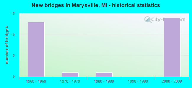
- New bridges - historical statistics
- 131960-1969
- 11970-1979
- 11980-1989
- 142000-2009

- Reconstructed bridges - Historical Statistics
- 21990-1999
- 42000-2009


- Bridge Condition - Deck
- 43.8%Good
- 50.0%Satisfactory
- 6.3%Fair

- Bridge Condition - Superstructure
- 25.0%Very good
- 31.3%Good
- 12.5%Satisfactory
- 31.3%Fair

- Bridge Condition - Substructure
- 25.0%Very good
- 56.3%Good
- 18.8%Satisfactory

- Bridge Condition - Channel
- 33.3%Good
- 16.7%Satisfactory
- 33.3%Fair
- 16.7%Poor
Find on map >> Show street view
Structure Number: 9931, Location: 1.5 MI W OF I-94 (Lat: 42.972044, Lng: -82.509686), Route carried "on" structure: Interstate 69, Year Built: 1966, Year Reconstructed: 2007, Status: Open, Structure Length: 7.41m (24.31ft), Average Daily Traffic: 9,344 (year 2007), Truck Traffic: 18%, Average Future Daily Traffic: 11,976 (year 2018), Design Load: HS 20, Features Intersected: CSX RR
Minimum Vertical Clearance: 30.48m (100.00ft), Kilometerpoint: 40.658, Lanes on structure: 2, Base Highway Network: Yes (Inventory Route: 96, Subroute: 2), Owner: State Highway Agency, Approaching Roadway Width: 12.2m (40.0ft), Skew: 5 degrees, Material/Design: Steel, Design/Construction: Stringer/Multi-beam, Number Of Spans In Main Unit: 3, Length of Maximum Span: 25.2m (82.7ft), Curb-To-Curb Width: 11.7m (38.4ft), Out-to-Out Width: 12.9m (42.3ft)
Condition: Deck: Satisfactory, Superstructure: Satisfactory, Substructure: Good, Operating Rating: 64.8 metric tons, Method Used To Determine Operating Rating: Load Factor (LF) rating reported by rating factor (RF) method using MS18 loading, Inventory Rating: 38.9 metric tons, Method Used To Determine Inventory Rating: Load Factor (LF) rating reported by rating factor (RF) method using MS18 loading, Structural Evaluation: Equal to present minimum criteria, Deck Geometry: Equal to present minimum criteria, Approach Roadway Alignment: Better than present minimum criteria, Designated Inspection Frequency: Every 24 months, Inspection Date: October 2021, Deck Structure Type: Concrete Cast-file-Place, Wearing Surface/Protective System: Wearing Surface: Latex Concrete
Find on map >> Show street view
Structure Number: 9935, Location: 3.1 MI NW OF I-94 (Lat: 42.979397, Lng: -82.541322), Route carried "on" structure: County highway 2012, Year Built: 1966, Year Reconstructed: 1997, Status: Open, Structure Length: 6.26m (20.54ft), Average Daily Traffic: 13,000 (year 1996), Truck Traffic: 6%, Average Future Daily Traffic: 13,000 (year 2016), Design Load: HS 20, Features Intersected: I-69, Facility Carried by Structure: WADHAMS RD
Minimum Vertical Clearance: 30.48m (100.00ft), Kilometerpoint: 23.183, Lanes on structure: 2, Lanes under structure: 4, Owner: State Highway Agency, Approaching Roadway Width: 9.8m (32.2ft), Material/Design: Prestressed concrete, Design/Construction: Box Beam or Girders - Single/Spread, Number Of Spans In Main Unit: 4, Length of Maximum Span: 21.7m (71.2ft), Curb-To-Curb Width: 9.8m (32.2ft), Out-to-Out Width: 10.8m (35.4ft)
Condition: Deck: Good, Superstructure: Fair, Substructure: Satisfactory, Operating Rating: 68.3 metric tons, Method Used To Determine Operating Rating: Load Factor (LF), Inventory Rating: 40.8 metric tons, Method Used To Determine Inventory Rating: Load Factor (LF), Structural Evaluation: Somewhat better than minimum adequacy, Deck Geometry: Meets minimum limits, Underclear: High priority of corrective action, Approach Roadway Alignment: Better than present minimum criteria, Designated Inspection Frequency: Every 24 months, Inspection Date: October 2021, Deck Structure Type: Concrete Cast-file-Place, Wearing Surface/Protective System: Wearing Surface: Epoxy Overlay, Deck Protection: Epoxy Coated Reinforcing
Find on map >> Show street view
Structure Number: 9937, Location: 1.0 MI W OF I-94 (Lat: 42.972428, Lng: -82.502739), Route carried "on" structure: County highway 2012, Year Built: 1966, Status: Open, Structure Length: 6.28m (20.60ft), Average Daily Traffic: 4,040 (year 1991), Truck Traffic: 2%, Average Future Daily Traffic: 4,646 (year 2011), Design Load: H 20, Features Intersected: I-69, Facility Carried by Structure: RANGE RD
Minimum Vertical Clearance: 30.48m (100.00ft), Kilometerpoint: 15.458, Lanes on structure: 2, Lanes under structure: 4, Owner: State Highway Agency, Approaching Roadway Width: 12.8m (42.0ft), Material/Design: Prestressed concrete, Design/Construction: Stringer/Multi-beam, Number Of Spans In Main Unit: 4, Length of Maximum Span: 21.9m (71.9ft), Curb or Sidewalk Widths: Left: 0.7m (2.3ft), Right: 0.7m (2.3ft), Curb-To-Curb Width: 8.5m (27.9ft), Out-to-Out Width: 10.8m (35.4ft)
Condition: Deck: Good, Superstructure: Fair, Substructure: Very good, Operating Rating: 68.7 metric tons, Method Used To Determine Operating Rating: Load Factor (LF) rating reported by rating factor (RF) method using MS18 loading, Inventory Rating: 41.1 metric tons, Method Used To Determine Inventory Rating: Load Factor (LF) rating reported by rating factor (RF) method using MS18 loading, Structural Evaluation: Somewhat better than minimum adequacy, Deck Geometry: Meets minimum limits, Underclear: High priority of corrective action, Approach Roadway Alignment: Better than present minimum criteria, Designated Inspection Frequency: Every 24 months, Inspection Date: Febuary 2022, Deck Structure Type: Concrete Cast-file-Place, Wearing Surface/Protective System: Wearing Surface: Latex Concrete
Find on map >> Show street view
Structure Number: 9984, Location: 13.4 MI NE OF MACOMB COL (Lat: 42.869358, Lng: -82.547381), Route carried "on" structure: Interstate 94, Year Built: 1964, Year Reconstructed: 2008, Status: Open, Structure Length: 6.22m (20.41ft), Average Daily Traffic: 12,752 (year 2007), Truck Traffic: 17%, Average Future Daily Traffic: 13,170 (year 2018), Design Load: HS 20+Mod, Features Intersected: PINE RIVER
Minimum Vertical Clearance: 30.48m (100.00ft), Kilometerpoint: 21.279, Lanes on structure: 2, Base Highway Network: Yes (Inventory Route: 96, Subroute: 6), Owner: State Highway Agency, Approaching Roadway Width: 12.2m (40.0ft), Skew: 12 degrees, Material/Design: Steel, Design/Construction: Stringer/Multi-beam, Number Of Spans In Main Unit: 3, Length of Maximum Span: 23.2m (76.1ft), Curb-To-Curb Width: 13.4m (44.0ft), Out-to-Out Width: 14.4m (47.2ft)
Condition: Deck: Satisfactory, Superstructure: Fair, Substructure: Good, Channel: Fair, Operating Rating: 56.4 metric tons, Method Used To Determine Operating Rating: Load Factor (LF) rating reported by rating factor (RF) method using MS18 loading, Inventory Rating: 33.7 metric tons, Method Used To Determine Inventory Rating: Load Factor (LF) rating reported by rating factor (RF) method using MS18 loading, Structural Evaluation: Somewhat better than minimum adequacy, Deck Geometry: Superior to present desirable criteria, Waterway Adequacy: Equal to present desirable criteria, Approach Roadway Alignment: Equal to present desirable criteria, Designated Inspection Frequency: Every 24 months, Inspection Date: August 2020, Deck Structure Type: Concrete Cast-file-Place, Wearing Surface/Protective System: Wearing Surface: Epoxy Overlay
Find on map >> Show street view
Structure Number: 9985, Location: 13.4 MI NE OF MACOMB COL (Lat: 42.869661, Lng: -82.547517), Route carried "on" structure: Interstate 94, Year Built: 1964, Year Reconstructed: 2008, Status: Open, Structure Length: 6.22m (20.41ft), Average Daily Traffic: 12,752 (year 2007), Truck Traffic: 17%, Average Future Daily Traffic: 13,170 (year 2018), Design Load: HS 20+Mod, Features Intersected: PINE RIVER
Minimum Vertical Clearance: 30.48m (100.00ft), Kilometerpoint: 21.268, Lanes on structure: 2, Base Highway Network: Yes (Inventory Route: 96, Subroute: 4), Owner: State Highway Agency, Approaching Roadway Width: 12.2m (40.0ft), Skew: 12 degrees, Material/Design: Steel, Design/Construction: Stringer/Multi-beam, Number Of Spans In Main Unit: 3, Length of Maximum Span: 23.2m (76.1ft), Curb-To-Curb Width: 13.4m (44.0ft), Out-to-Out Width: 14.4m (47.2ft)
Condition: Deck: Satisfactory, Superstructure: Fair, Substructure: Good, Channel: Fair, Operating Rating: 72.9 metric tons, Method Used To Determine Operating Rating: Load Factor (LF) rating reported by rating factor (RF) method using MS18 loading, Inventory Rating: 43.7 metric tons, Method Used To Determine Inventory Rating: Load Factor (LF) rating reported by rating factor (RF) method using MS18 loading, Structural Evaluation: Somewhat better than minimum adequacy, Deck Geometry: Superior to present desirable criteria, Waterway Adequacy: Equal to present desirable criteria, Approach Roadway Alignment: Equal to present desirable criteria, Designated Inspection Frequency: Every 24 months, Inspection Date: August 2020, Deck Structure Type: Concrete Cast-file-Place, Wearing Surface/Protective System: Wearing Surface: Epoxy Overlay
Find on map >> Show street view
Structure Number: 9994, Location: 0.6 MI W OF M-21 (Lat: 42.962461, Lng: -82.489508), Route carried "on" structure: Interstate 94, Year Built: 2003, Status: Open, Structure Length: 2.74m (8.99ft), Average Daily Traffic: 14,887 (year 2007), Truck Traffic: 12%, Average Future Daily Traffic: 17,163 (year 2018), Design Load: HS 25 or greater, Features Intersected: GTW RR
Minimum Vertical Clearance: 30.48m (100.00ft), Kilometerpoint: 33.719, Lanes on structure: 2, Base Highway Network: Yes (Inventory Route: 96, Subroute: 6), Owner: State Highway Agency, Approaching Roadway Width: 12.5m (41.0ft), Skew: 12 degrees, Material/Design: Prestressed concrete, Design/Construction: Stringer/Multi-beam, Number Of Spans In Main Unit: 1, Length of Maximum Span: 25.8m (84.6ft), Curb-To-Curb Width: 13.4m (44.0ft), Out-to-Out Width: 14.4m (47.2ft)
Condition: Deck: Satisfactory, Superstructure: Good, Substructure: Good, Operating Rating: 97.2 metric tons, Method Used To Determine Operating Rating: Load Factor (LF) rating reported by rating factor (RF) method using MS18 loading, Inventory Rating: 56.7 metric tons, Method Used To Determine Inventory Rating: Load Factor (LF) rating reported by rating factor (RF) method using MS18 loading, Structural Evaluation: Better than present minimum criteria, Deck Geometry: Superior to present desirable criteria, Underclear: Superior to present desirable criteria, Approach Roadway Alignment: Equal to present desirable criteria, Designated Inspection Frequency: Every 24 months, Inspection Date: August 2020, Deck Structure Type: Concrete Cast-file-Place, Wearing Surface/Protective System: Wearing Surface: Epoxy Overlay, Deck Protection: Epoxy Coated Reinforcing
Find on map >> Show street view
Structure Number: 9995, Location: 0.6 MI W OF M-21 (Lat: 42.962314, Lng: -82.489864), Route carried "on" structure: Interstate 94, Year Built: 2003, Status: Open, Structure Length: 2.74m (8.99ft), Average Daily Traffic: 14,887 (year 2007), Truck Traffic: 12%, Average Future Daily Traffic: 17,163 (year 2018), Design Load: HS 25 or greater, Features Intersected: GTW RR
Minimum Vertical Clearance: 30.48m (100.00ft), Kilometerpoint: 33.654, Lanes on structure: 2, Base Highway Network: Yes (Inventory Route: 96, Subroute: 4), Owner: State Highway Agency, Approaching Roadway Width: 12.5m (41.0ft), Skew: 12 degrees, Material/Design: Prestressed concrete, Design/Construction: Box Beam or Girders - Multiple, Number Of Spans In Main Unit: 1, Length of Maximum Span: 25.8m (84.6ft), Curb-To-Curb Width: 13.4m (44.0ft), Out-to-Out Width: 14.4m (47.2ft)
Condition: Deck: Good, Superstructure: Good, Substructure: Very good, Operating Rating: 97.2 metric tons, Method Used To Determine Operating Rating: Load Factor (LF) rating reported by rating factor (RF) method using MS18 loading, Inventory Rating: 56.7 metric tons, Method Used To Determine Inventory Rating: Load Factor (LF) rating reported by rating factor (RF) method using MS18 loading, Structural Evaluation: Better than present minimum criteria, Deck Geometry: Superior to present desirable criteria, Underclear: Superior to present desirable criteria, Approach Roadway Alignment: Equal to present desirable criteria, Designated Inspection Frequency: Every 24 months, Inspection Date: August 2020, Deck Structure Type: Concrete Cast-file-Place, Wearing Surface/Protective System: Wearing Surface: Epoxy Overlay, Deck Protection: Epoxy Coated Reinforcing
Find on map >> Show street view
Structure Number: 9996, Location: 0.4 MI W M-21 (GRISWOLD) (Lat: 42.964961, Lng: -82.489597), Route carried "on" structure: Interstate 94, Year Built: 2003, Status: Open, Structure Length: 2.35m (7.71ft), Average Daily Traffic: 14,887 (year 2007), Truck Traffic: 11%, Average Future Daily Traffic: 20,500 (year 2028), Design Load: HS 20+Mod, Features Intersected: CSX & GTW RRS
Minimum Vertical Clearance: 30.48m (100.00ft), Kilometerpoint: 33.995, Lanes on structure: 2, Lanes under structure: 2, Base Highway Network: Yes (Inventory Route: 96, Subroute: 6), Owner: State Highway Agency, Approaching Roadway Width: 13.4m (44.0ft), Skew: 10 degrees, Material/Design: Prestressed concrete, Design/Construction: Stringer/Multi-beam, Number Of Spans In Main Unit: 1, Length of Maximum Span: 22.3m (73.2ft), Curb-To-Curb Width: 13.4m (44.0ft), Out-to-Out Width: 14.4m (47.2ft)
Condition: Deck: Satisfactory, Superstructure: Very good, Substructure: Good, Operating Rating: 73.9 metric tons, Method Used To Determine Operating Rating: Load Factor (LF) rating reported by rating factor (RF) method using MS18 loading, Inventory Rating: 41.5 metric tons, Method Used To Determine Inventory Rating: Load Factor (LF) rating reported by rating factor (RF) method using MS18 loading, Structural Evaluation: Better than present minimum criteria, Deck Geometry: Superior to present desirable criteria, Underclear: Superior to present desirable criteria, Approach Roadway Alignment: Equal to present desirable criteria, Designated Inspection Frequency: Every 24 months, Inspection Date: August 2020, Roadway Improvement Cost: $999,999,000, Deck Structure Type: Concrete Cast-file-Place, Wearing Surface/Protective System: Wearing Surface: Epoxy Overlay, Deck Protection: Epoxy Coated Reinforcing
Find on map >> Show street view
Structure Number: 9997, Location: 0.4 MI W M-21 (GRISWOLD) (Lat: 42.964992, Lng: -82.489956), Route carried "on" structure: Interstate 94, Year Built: 2003, Status: Open, Structure Length: 2.35m (7.71ft), Average Daily Traffic: 14,887 (year 2007), Truck Traffic: 11%, Average Future Daily Traffic: 20,500 (year 2028), Design Load: HS 25 or greater, Features Intersected: CSX & GTW RRS
Minimum Vertical Clearance: 30.48m (100.00ft), Kilometerpoint: 33.952, Lanes on structure: 2, Lanes under structure: 2, Base Highway Network: Yes (Inventory Route: 96, Subroute: 4), Owner: State Highway Agency, Approaching Roadway Width: 13.4m (44.0ft), Skew: 10 degrees, Material/Design: Prestressed concrete, Design/Construction: Stringer/Multi-beam, Number Of Spans In Main Unit: 1, Length of Maximum Span: 22.3m (73.2ft), Curb-To-Curb Width: 13.4m (44.0ft), Out-to-Out Width: 14.4m (47.2ft)
Condition: Deck: Satisfactory, Superstructure: Very good, Substructure: Good, Operating Rating: 69.2 metric tons, Method Used To Determine Operating Rating: Load Factor (LF), Inventory Rating: 41.4 metric tons, Method Used To Determine Inventory Rating: Load Factor (LF), Structural Evaluation: Better than present minimum criteria, Deck Geometry: Superior to present desirable criteria, Underclear: Superior to present desirable criteria, Approach Roadway Alignment: Equal to present desirable criteria, Designated Inspection Frequency: Every 24 months, Inspection Date: August 2020, Deck Structure Type: Concrete Cast-file-Place, Wearing Surface/Protective System: Wearing Surface: Epoxy Overlay, Deck Protection: Epoxy Coated Reinforcing
Find on map >> Show street view
Structure Number: 10009, Location: 0.8 MI NE OF M-25 (Lat: 42.920306, Lng: -82.506194), Route carried "on" structure: County highway 2012, Year Built: 1965, Year Reconstructed: 2003, Status: Open, Structure Length: 6.55m (21.49ft), Average Daily Traffic: 4,437 (year 1995), Truck Traffic: 3%, Average Future Daily Traffic: 7,100 (year 2023), Design Load: H 20, Features Intersected: I-94, Facility Carried by Structure: SMITH CREEK RD
Minimum Vertical Clearance: 30.48m (100.00ft), Kilometerpoint: 22.813, Lanes on structure: 2, Lanes under structure: 4, Owner: State Highway Agency, Approaching Roadway Width: 9.8m (32.2ft), Material/Design: Prestressed concrete, Design/Construction: Box Beam or Girders - Single/Spread, Number Of Spans In Main Unit: 4, Length of Maximum Span: 21.8m (71.5ft), Curb-To-Curb Width: 9.8m (32.2ft), Out-to-Out Width: 10.7m (35.1ft)
Condition: Deck: Satisfactory, Superstructure: Good, Substructure: Good, Operating Rating: 78.7 metric tons, Method Used To Determine Operating Rating: Load Factor (LF) rating reported by rating factor (RF) method using MS18 loading, Inventory Rating: 30.8 metric tons, Method Used To Determine Inventory Rating: Load Factor (LF) rating reported by rating factor (RF) method using MS18 loading, Structural Evaluation: Better than present minimum criteria, Deck Geometry: Meets minimum limits, Underclear: Somewhat better than minimum adequacy, Approach Roadway Alignment: Equal to present desirable criteria, Designated Inspection Frequency: Every 24 months, Inspection Date: August 2020, Deck Structure Type: Concrete Cast-file-Place, Wearing Surface/Protective System: Wearing Surface: Epoxy Overlay, Deck Protection: Epoxy Coated Reinforcing
Find on map >> Show street view
Structure Number: 1001, Location: 2.3 MI NE OF M-25 (Lat: 42.935122, Lng: -82.506667), Route carried "on" structure: County highway 2012, Year Built: 1965, Status: Open, Structure Length: 6.55m (21.49ft), Average Daily Traffic: 1,450 (year 1990), Truck Traffic: 2%, Average Future Daily Traffic: 1,668 (year 2010), Design Load: H 20, Features Intersected: I-94, Facility Carried by Structure: RAVENSWOOD RD
Minimum Vertical Clearance: 30.48m (100.00ft), Kilometerpoint: 4.075, Lanes on structure: 2, Lanes under structure: 4, Owner: State Highway Agency, Approaching Roadway Width: 12.8m (42.0ft), Material/Design: Steel, Design/Construction: Stringer/Multi-beam, Number Of Spans In Main Unit: 4, Length of Maximum Span: 21.9m (71.9ft), Curb or Sidewalk Widths: Left: 0.7m (2.3ft), Right: 0.7m (2.3ft), Curb-To-Curb Width: 7.9m (25.9ft), Out-to-Out Width: 10.1m (33.1ft)
Condition: Deck: Fair, Superstructure: Satisfactory, Substructure: Satisfactory, Operating Rating: 59.3 metric tons, Method Used To Determine Operating Rating: Load Factor (LF) rating reported by rating factor (RF) method using MS18 loading, Inventory Rating: 35.6 metric tons, Method Used To Determine Inventory Rating: Load Factor (LF) rating reported by rating factor (RF) method using MS18 loading, Structural Evaluation: Equal to present minimum criteria, Deck Geometry: Meets minimum limits, Underclear: Meets minimum limits, Approach Roadway Alignment: Equal to present desirable criteria, Designated Inspection Frequency: Every 24 months, Inspection Date: August 2020, Deck Structure Type: Concrete Cast-file-Place, Wearing Surface/Protective System: Wearing Surface: Epoxy Overlay
Find on map >> Show street view
Structure Number: 10054, Location: SEC. 27-34 KIMBALL TWP. (Lat: 42.918650, Lng: -82.558653), Route carried "on" structure: County highway 7756, Year Built: 1973, Year Reconstructed: 2013, Status: Open, Structure Length: 2.74m (8.99ft), Average Daily Traffic: 3,160 (year 2012), Truck Traffic: 28%, Average Future Daily Traffic: 3,860 (year 2032), Design Load: HS 20+Mod, Features Intersected: PINE RIVER, Facility Carried by Structure: SMITHS CREEK ROAD
Minimum Vertical Clearance: 30.48m (100.00ft), Kilometerpoint: 18.497, Lanes on structure: 2, Owner: County Highway Agency, Approaching Roadway Width: 12.2m (40.0ft), Material/Design: Prestressed concrete, Design/Construction: Stringer/Multi-beam, Number Of Spans In Main Unit: 1, Length of Maximum Span: 26.5m (86.9ft), Curb-To-Curb Width: 11.0m (36.1ft), Out-to-Out Width: 11.9m (39.0ft)
Condition: Deck: Good, Superstructure: Very good, Substructure: Good, Channel: Satisfactory, Operating Rating: 71.3 metric tons, Method Used To Determine Operating Rating: Load and Resistance Factor Rating (LRFR) rating reported by rating factor(RF) method using HL-93 loadings, Inventory Rating: 41.8 metric tons, Method Used To Determine Inventory Rating: Load and Resistance Factor Rating (LRFR) rating reported by rating factor(RF) method using HL-93 loadings, Structural Evaluation: Better than present minimum criteria, Deck Geometry: Somewhat better than minimum adequacy, Waterway Adequacy: Superior to present desirable criteria, Approach Roadway Alignment: Equal to present desirable criteria, Designated Inspection Frequency: Every 24 months, Inspection Date: November 2021, Deck Structure Type: Concrete Cast-file-Place, Wearing Surface/Protective System: Wearing Surface: Integral Concrete
Find on map >> Show street view
Structure Number: 10107, Location: SEC. 15-16 ST. CLAIR TWP. (Lat: 42.871347, Lng: -82.557647), Route carried "on" structure: County highway 7769, Year Built: 2007, Status: Open, Structure Length: 4.45m (14.60ft), Average Daily Traffic: 4,641 (year 2019), Truck Traffic: 10%, Average Future Daily Traffic: 6,870 (year 2039), Design Load: HS 20+Mod, Features Intersected: PINE RIVER, Facility Carried by Structure: WADHAMS ROAD
Minimum Vertical Clearance: 30.48m (100.00ft), Kilometerpoint: 10.645, Lanes on structure: 2, Owner: County Highway Agency, Approaching Roadway Width: 12.2m (40.0ft), Material/Design: Prestressed concrete, Design/Construction: Stringer/Multi-beam, Number Of Spans In Main Unit: 1, Length of Maximum Span: 43.7m (143.4ft), Curb-To-Curb Width: 12.2m (40.0ft), Out-to-Out Width: 13.0m (42.7ft)
Condition: Deck: Good, Superstructure: Very good, Substructure: Very good, Channel: Good, Operating Rating: 62.5 metric tons, Method Used To Determine Operating Rating: Load and Resistance Factor Rating (LRFR) rating reported by rating factor(RF) method using HL-93 loadings, Inventory Rating: 32.1 metric tons, Method Used To Determine Inventory Rating: Load and Resistance Factor Rating (LRFR) rating reported by rating factor(RF) method using HL-93 loadings, Structural Evaluation: Better than present minimum criteria, Deck Geometry: Equal to present minimum criteria, Waterway Adequacy: Better than present minimum criteria, Approach Roadway Alignment: Equal to present desirable criteria, Designated Inspection Frequency: Every 24 months, Inspection Date: Febuary 2020, Deck Structure Type: Concrete Cast-file-Place, Wearing Surface/Protective System: Wearing Surface: Monolithic Concrete, Deck Protection: Epoxy Coated Reinforcing
Find on map >> Show street view
Structure Number: 10208, Location: SEC. 22-27 KIMBALL TWP. (Lat: 42.933539, Lng: -82.554342), Route carried "on" structure: ServiceCounty highway , Year Built: 1984, Status: Open, Structure Length: 5.49m (18.01ft), Average Daily Traffic: 300 (year 1999), Truck Traffic: 3%, Average Future Daily Traffic: 540 (year 2019), Design Load: HS 20+Mod, Features Intersected: PINE RIVER, Facility Carried by Structure: RAVENSWOOD ROAD
Minimum Vertical Clearance: 30.48m (100.00ft), Kilometerpoint: 0.180, Lanes on structure: 2, Owner: County Highway Agency, Approaching Roadway Width: 6.1m (20.0ft), Skew: 5 degrees, Material/Design: Prestressed concrete, Design/Construction: Stringer/Multi-beam, Number Of Spans In Main Unit: 1, Number Of Approach Spans: 2, Length of Maximum Span: 17.4m (57.1ft), Curb-To-Curb Width: 9.1m (29.9ft), Out-to-Out Width: 9.9m (32.5ft)
Condition: Deck: Good, Superstructure: Fair, Substructure: Satisfactory, Channel: Good, Operating Rating: 64.5 metric tons, Method Used To Determine Operating Rating: Load Factor (LF) rating reported by rating factor (RF) method using MS18 loading, Inventory Rating: 38.6 metric tons, Method Used To Determine Inventory Rating: Load Factor (LF) rating reported by rating factor (RF) method using MS18 loading, Structural Evaluation: Somewhat better than minimum adequacy, Deck Geometry: Equal to present minimum criteria, Waterway Adequacy: Equal to present minimum criteria, Approach Roadway Alignment: Equal to present minimum criteria, Designated Inspection Frequency: Every 24 months, Underwater Inspection Frequency: Every 60 months, Inspection Date: November 2021, Underwater Inspection Date: October 2017, Deck Structure Type: Concrete Cast-file-Place, Wearing Surface/Protective System: Wearing Surface: Monolithic Concrete, Deck Protection: Epoxy Coated Reinforcing
Find on map >> Show street view
Structure Number: 1021, Location: SEC. 15-22 KIMBALL TWP. (Lat: 42.948025, Lng: -82.560792), Route carried "on" structure: ServiceCounty highway , Year Built: 1962, Status: Open, Structure Length: 0.74m (2.43ft), Average Daily Traffic: 752 (year 1994), Truck Traffic: 3%, Average Future Daily Traffic: 1,050 (year 2014), Design Load: HS 20+Mod, Features Intersected: UNNAMED CREEK, Facility Carried by Structure: DOVE ROAD
Minimum Vertical Clearance: 30.48m (100.00ft), Kilometerpoint: 3.439, Lanes on structure: 2, Owner: County Highway Agency, Approaching Roadway Width: 8.5m (27.9ft), Material/Design: Steel, Design/Construction: Culvert, Number Of Spans In Main Unit: 2, Length of Maximum Span: 3.5m (11.5ft), Out-to-Out Width: 15.2m (49.9ft)
Condition: Channel: Poor, Culverts: Fair, Operating Rating: 97.2 metric tons, Method Used To Determine Operating Rating: Load and Resistance Factor Rating (LRFR) rating reported by rating factor(RF) method using HL-93 loadings, Inventory Rating: 97.2 metric tons, Method Used To Determine Inventory Rating: Load and Resistance Factor Rating (LRFR) rating reported by rating factor(RF) method using HL-93 loadings, Structural Evaluation: Somewhat better than minimum adequacy, Waterway Adequacy: Equal to present minimum criteria, Approach Roadway Alignment: Equal to present desirable criteria, Length Of Structure Improvement: 0.79m (2.59ft), Designated Inspection Frequency: Every 24 months, Inspection Date: November 2021, Bridge Improvement Cost: $160,000, Roadway Improvement Cost: $40,000, Total Project Cost: $200,000, Deck Structure Type: Other, Wearing Surface/Protective System: Wearing Surface: Gravel
Find on map >> Show street view
Structure Number: 1316, Location: PORT HURON TWP SEC 8-17 (Lat: 42.965875, Lng: -82.489608), Route carried "on" structure: Interstate 94, Year Built: 2003, Status: Open, Structure Length: 2.49m (8.17ft), Average Daily Traffic: 14,887 (year 2007), Truck Traffic: 14%, Average Future Daily Traffic: 20,500 (year 2028), Design Load: HS 25 or greater, Features Intersected: GRISWOLD ROAD
Minimum Vertical Clearance: 30.48m (100.00ft), Kilometerpoint: 34.098, Lanes on structure: 2, Lanes under structure: 2, Base Highway Network: Yes (Inventory Route: 96, Subroute: 6), Owner: State Highway Agency, Approaching Roadway Width: 13.4m (44.0ft), Material/Design: Prestressed concrete, Design/Construction: Stringer/Multi-beam, Number Of Spans In Main Unit: 1, Length of Maximum Span: 23.7m (77.8ft), Curb-To-Curb Width: 13.4m (44.0ft), Out-to-Out Width: 14.5m (47.6ft)
Condition: Deck: Satisfactory, Superstructure: Good, Substructure: Very good, Operating Rating: 67.3 metric tons, Method Used To Determine Operating Rating: Load Factor (LF), Inventory Rating: 42.6 metric tons, Method Used To Determine Inventory Rating: Load Factor (LF), Structural Evaluation: Better than present minimum criteria, Deck Geometry: Superior to present desirable criteria, Underclear: Equal to present minimum criteria, Approach Roadway Alignment: Equal to present minimum criteria, Designated Inspection Frequency: Every 24 months, Inspection Date: July 2020, Deck Structure Type: Concrete Cast-file-Place, Wearing Surface/Protective System: Wearing Surface: Epoxy Overlay, Deck Protection: Epoxy Coated Reinforcing
Find on map >> Show street view
Structure Number: 13161, Location: PORT HURON TWP SEC 7-18 (Lat: 42.965858, Lng: -82.489972), Route carried "on" structure: Interstate 94, Year Built: 2003, Status: Open, Structure Length: 2.49m (8.17ft), Average Daily Traffic: 14,887 (year 2007), Truck Traffic: 14%, Average Future Daily Traffic: 20,500 (year 2028), Design Load: HS 25 or greater, Features Intersected: GRISWOLD ROAD
Minimum Vertical Clearance: 30.48m (100.00ft), Kilometerpoint: 34.048, Lanes on structure: 2, Lanes under structure: 2, Base Highway Network: Yes (Inventory Route: 96, Subroute: 4), Owner: State Highway Agency, Approaching Roadway Width: 13.4m (44.0ft), Skew: 10 degrees, Material/Design: Prestressed concrete, Design/Construction: Stringer/Multi-beam, Number Of Spans In Main Unit: 1, Length of Maximum Span: 23.7m (77.8ft), Curb-To-Curb Width: 13.4m (44.0ft), Out-to-Out Width: 14.5m (47.6ft)
Condition: Deck: Good, Superstructure: Good, Substructure: Good, Operating Rating: 67.3 metric tons, Method Used To Determine Operating Rating: Load Factor (LF), Inventory Rating: 42.6 metric tons, Method Used To Determine Inventory Rating: Load Factor (LF), Structural Evaluation: Better than present minimum criteria, Deck Geometry: Superior to present desirable criteria, Underclear: Equal to present minimum criteria, Approach Roadway Alignment: Equal to present minimum criteria, Designated Inspection Frequency: Every 24 months, Inspection Date: July 2020, Deck Structure Type: Concrete Cast-file-Place, Wearing Surface/Protective System: Wearing Surface: Epoxy Overlay, Deck Protection: Epoxy Coated Reinforcing
Find on map >> Show street view
Structure Number: 9935, Location: 3.1 MI NW OF I-94 (Lat: 42.979397, Lng: -82.541322), Route carried "under" structure: Interstate 69, Year Built: 1966, Structure Length: 0. m, Average Daily Traffic: 19,000 (year 2009), Truck Traffic: 22%, Features Intersected: I-69, Facility Carried by Structure: WADHAMS RD
Minimum Vertical Clearance: 4.60m (15.09ft), Kilometerpoint: 37.877, Lanes on structure: 2, Lanes under structure: 4, Material/Design: Prestressed concrete, Design/Construction: Box Beam or Girders - Single/Spread, Length of Maximum Span: 21.7m (71.2ft)
Find on map >> Show street view
Structure Number: 9936, Location: 2.1 MI NW OF I-94 (Lat: 42.974236, Lng: -82.523594), Route carried "under" structure: Interstate 69, Year Built: 1966, Structure Length: 0. m, Average Daily Traffic: 19,000 (year 2009), Truck Traffic: 22%, Features Intersected: I-69, Facility Carried by Structure: ALLEN RD
Minimum Vertical Clearance: 4.55m (14.93ft), Kilometerpoint: 39.437, Lanes on structure: 2, Lanes under structure: 4, Material/Design: Steel, Design/Construction: Stringer/Multi-beam, Length of Maximum Span: 23.8m (78.1ft)
Find on map >> Show street view
Structure Number: 9937, Location: 1.0 MI W OF I-94 (Lat: 42.972428, Lng: -82.502739), Route carried "under" structure: Interstate 69, Year Built: 1966, Structure Length: 0. m, Average Daily Traffic: 19,000 (year 2009), Truck Traffic: 22%, Features Intersected: I-69, Facility Carried by Structure: RANGE RD
Minimum Vertical Clearance: 4.57m (14.99ft), Kilometerpoint: 41.194, Lanes on structure: 2, Lanes under structure: 4, Material/Design: Prestressed concrete, Design/Construction: Stringer/Multi-beam, Length of Maximum Span: 21.9m (71.9ft)
Find on map >> Show street view
Structure Number: 9996, Location: 0.4 MI W M-21 (GRISWOLD) (Lat: 42.964961, Lng: -82.489597), Route carried "under" structure: County highway , Year Built: 2003, Structure Length: 0. m, Average Daily Traffic: 9,999 (year 2000), Features Intersected: CSX & GTW RRS, Facility Carried by Structure: I-94 EB
Minimum Vertical Clearance: 7.39m (24.25ft), Kilometerpoint: 41.048, Lanes on structure: 2, Lanes under structure: 2, Material/Design: Prestressed concrete, Design/Construction: Stringer/Multi-beam, Length of Maximum Span: 22.3m (73.2ft)
Find on map >> Show street view
Structure Number: 9997, Location: 0.4 MI W M-21 (GRISWOLD) (Lat: 42.964992, Lng: -82.489956), Route carried "under" structure: County highway , Year Built: 2003, Structure Length: 0. m, Average Daily Traffic: 77,777 (year 1995), Features Intersected: CSX & GTW RRS, Facility Carried by Structure: I-94 WB
Minimum Vertical Clearance: 7.34m (24.08ft), Kilometerpoint: 41.019, Lanes on structure: 2, Lanes under structure: 2, Material/Design: Prestressed concrete, Design/Construction: Stringer/Multi-beam, Length of Maximum Span: 22.3m (73.2ft)
Find on map >> Show street view
Structure Number: 10007, Location: @ I94BL (GRATIOT)- (Lat: 42.907489, Lng: -82.505103), Route carried "under" structure: Business Interstate 94, Year Built: 2006, Structure Length: 0. m, Average Daily Traffic: 25,504 (year 2007), Truck Traffic: 13%, Features Intersected: I-94 BL (GRATIOT)
Minimum Vertical Clearance: 5.39m (17.68ft), Kilometerpoint: 26.933, Lanes on structure: 3, Lanes under structure: 6, Material/Design: Prestressed concrete, Design/Construction: Stringer/Multi-beam, Length of Maximum Span: 28.3m (92.8ft)
Find on map >> Show street view
Structure Number: 10008, Location: @I-94 BL (GRATIOT) (Lat: 42.907322, Lng: -82.505475), Route carried "under" structure: Business Interstate 94, Year Built: 2006, Structure Length: 0. m, Average Daily Traffic: 25,504 (year 2007), Truck Traffic: 13%, Features Intersected: I-94 BL
Minimum Vertical Clearance: 5.18m (16.99ft), Kilometerpoint: 26.866, Lanes on structure: 3, Lanes under structure: 6, Material/Design: Prestressed concrete, Design/Construction: Stringer/Multi-beam, Length of Maximum Span: 28.3m (92.8ft)
Find on map >> Show street view
Structure Number: 10009, Location: 0.8 MI NE OF M-25 (Lat: 42.920306, Lng: -82.506194), Route carried "under" structure: Interstate 94, Year Built: 1965, Structure Length: 0. m, Average Daily Traffic: 24,284 (year 2007), Truck Traffic: 13%, Features Intersected: I-94, Facility Carried by Structure: SMITH CREEK RD
Minimum Vertical Clearance: 5.18m (16.99ft), Kilometerpoint: 28.362, Lanes on structure: 2, Lanes under structure: 4, Material/Design: Prestressed concrete, Design/Construction: Box Beam or Girders - Single/Spread, Length of Maximum Span: 21.8m (71.5ft)
Find on map >> Show street view
Structure Number: 1001, Location: 2.3 MI NE OF M-25 (Lat: 42.935122, Lng: -82.506667), Route carried "under" structure: Interstate 94, Year Built: 1965, Structure Length: 0. m, Average Daily Traffic: 24,284 (year 2007), Truck Traffic: 13%, Features Intersected: I-94, Facility Carried by Structure: RAVENSWOOD RD
Minimum Vertical Clearance: 4.98m (16.34ft), Kilometerpoint: 30.006, Lanes on structure: 2, Lanes under structure: 4, Material/Design: Steel, Design/Construction: Stringer/Multi-beam, Length of Maximum Span: 21.9m (71.9ft)
Find on map >> Show street view
Structure Number: 10011, Location: 3.3 MI NE OF M-25 (Lat: 42.951800, Lng: -82.501922), Route carried "under" structure: Interstate 94, Year Built: 2003, Structure Length: 0. m, Average Daily Traffic: 29,774 (year 2007), Truck Traffic: 12%, Features Intersected: I-94, Facility Carried by Structure: RANGE RD
Minimum Vertical Clearance: 5.08m (16.67ft), Kilometerpoint: 32.032, Lanes on structure: 3, Lanes under structure: 5, Material/Design: Prestressed concrete, Design/Construction: Stringer/Multi-beam, Length of Maximum Span: 33.3m (109.3ft)
Find on map >> Show street view
Structure Number: 1316, Location: PORT HURON TWP SEC 8-17 (Lat: 42.965875, Lng: -82.489608), Route carried "under" structure: County highway , Year Built: 2003, Structure Length: 0. m, Average Daily Traffic: 4,020 (year 2010), Features Intersected: GRISWOLD ROAD, Facility Carried by Structure: I-94 EB
Minimum Vertical Clearance: 6.10m (20.01ft), Kilometerpoint: 10.844, Lanes on structure: 2, Lanes under structure: 2, Material/Design: Prestressed concrete, Design/Construction: Stringer/Multi-beam, Length of Maximum Span: 23.7m (77.8ft)
Find on map >> Show street view
Structure Number: 13161, Location: PORT HURON TWP SEC 7-18 (Lat: 42.965858, Lng: -82.489972), Route carried "under" structure: County highway , Year Built: 2003, Structure Length: 0. m, Average Daily Traffic: 9,999 (year 2003), Features Intersected: GRISWOLD ROAD, Facility Carried by Structure: I-94 WB
Minimum Vertical Clearance: 6.10m (20.01ft), Kilometerpoint: 10.814, Lanes on structure: 2, Lanes under structure: 2, Material/Design: Prestressed concrete, Design/Construction: Stringer/Multi-beam, Length of Maximum Span: 23.7m (77.8ft)