Bridge Statistics for McDonough, Georgia (GA)
Condition, Traffic, Stress, Structural Evaluation, Project Costs
- National Bridge Inventory (NBI) Statistics
- 41Number of bridges
- 410ft / 125mTotal length
- $147,321,000Total costs
- 983,700Total average daily traffic
- 10,168Total average daily truck traffic
- National Bridge Inventory (NBI) Registered Bridges for McDonough
- No street view available for this location
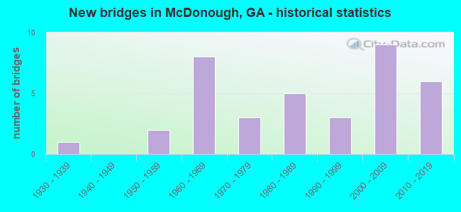
- New bridges - historical statistics
- 11930-1939
- 21950-1959
- 81960-1969
- 31970-1979
- 51980-1989
- 31990-1999
- 92000-2009
- 62010-2019
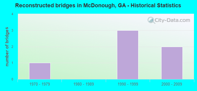
- Reconstructed bridges - Historical Statistics
- 11970-1979
- 01980-1989
- 31990-1999
- 22000-2009
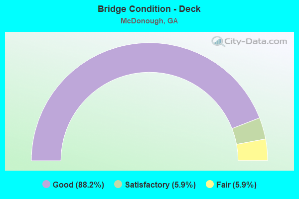
- Bridge Condition - Deck
- 88.2%Good
- 5.9%Satisfactory
- 5.9%Fair
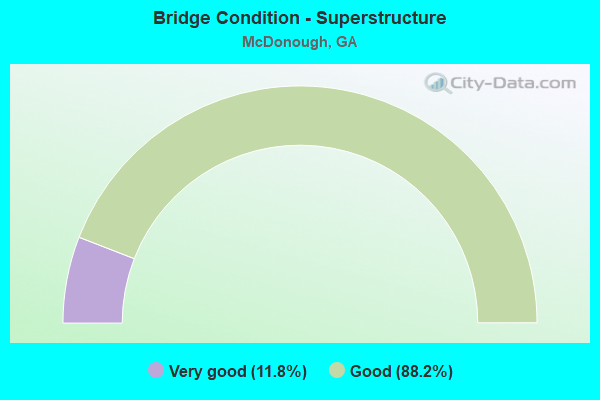
- Bridge Condition - Superstructure
- 11.8%Very good
- 88.2%Good
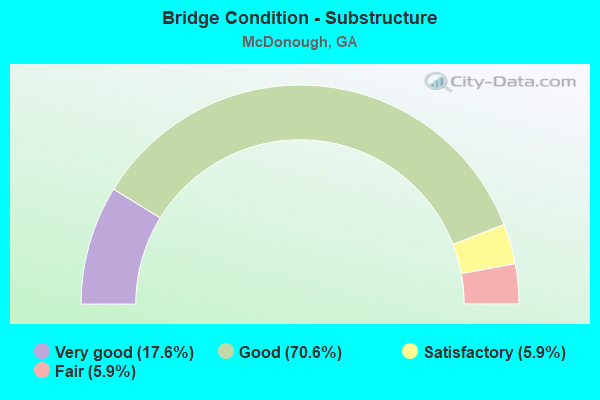
- Bridge Condition - Substructure
- 17.6%Very good
- 70.6%Good
- 5.9%Satisfactory
- 5.9%Fair
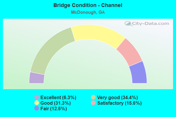
- Bridge Condition - Channel
- 6.3%Excellent
- 34.4%Very good
- 31.3%Good
- 15.6%Satisfactory
- 12.5%Fair

- Bridge Condition - Culverts
- 95.0%Good
- 5.0%Satisfactory
Find on map >> Show street view
Structure Number: 151001, Location: 1 MI N OF MCDONOUGH (Lat: 33.464678, Lng: -84.156528), Route carried "on" structure: State highway 42, Year Built: 1975, Status: Open, Structure Length: 1.01m (3.31ft), Average Daily Traffic: 11,860 (year 2011), Truck Traffic: 1%, Average Future Daily Traffic: 17,790 (year 2031), Design Load: HS 20, Features Intersected: CAMP CREEK
Minimum Vertical Clearance: 30+ m (98+ ft), Kilometerpoint: 20.921, Lanes on structure: 2, Base Highway Network: Yes, Owner: State Highway Agency, Approaching Roadway Width: 8.5m (27.9ft), Skew: 3 degrees, Material/Design: Concrete, Design/Construction: Culvert, Number Of Spans In Main Unit: 3, Length of Maximum Span: 3.0m (9.8ft)
Condition: Channel: Satisfactory, Culverts: Satisfactory, Operating Rating: 64.4 metric tons, Method Used To Determine Operating Rating: Load Factor (LF), Inventory Rating: 36.2 metric tons, Method Used To Determine Inventory Rating: Load Factor (LF), Structural Evaluation: Equal to present minimum criteria, Waterway Adequacy: Equal to present desirable criteria, Approach Roadway Alignment: Somewhat better than minimum adequacy, Designated Inspection Frequency: Every 24 months, Inspection Date: November 2020, Bridge Improvement Cost: $129,000, Roadway Improvement Cost: $13,000, Total Project Cost: $193,000
Find on map >> Show street view
Structure Number: 1510011, Location: 1.5 MI N OF MCDONOUGH (Lat: 33.470989, Lng: -84.161078), Route carried "on" structure: US 23, Year Built: 1936, Year Reconstructed: 1975, Status: Open, Structure Length: 4.39m (14.40ft), Average Daily Traffic: 12,950 (year 2012), Truck Traffic: 1%, Average Future Daily Traffic: 19,425 (year 2032), Design Load: HS 20+Mod, Features Intersected: WALNUT CREEK
Minimum Vertical Clearance: 30+ m (98+ ft), Kilometerpoint: 22.531, Lanes on structure: 2, Base Highway Network: Yes, Owner: State Highway Agency, Approaching Roadway Width: 8.5m (27.9ft), Skew: 3 degrees, Material/Design: Concrete, Design/Construction: Tee Beam, Number Of Spans In Main Unit: 4, Length of Maximum Span: 11.0m (36.1ft), Curb or Sidewalk Widths: Left: 0.2m (0.7ft), Right: 0.2m (0.7ft), Curb-To-Curb Width: 11.8m (38.7ft), Out-to-Out Width: 13.0m (42.7ft)
Condition: Deck: Good, Superstructure: Good, Substructure: Good, Channel: Satisfactory, Operating Rating: 33.5 metric tons, Method Used To Determine Operating Rating: Load Factor (LF), Inventory Rating: 19.9 metric tons, Method Used To Determine Inventory Rating: Load Factor (LF), Structural Evaluation: Somewhat better than minimum adequacy, Deck Geometry: Somewhat better than minimum adequacy, Waterway Adequacy: Equal to present minimum criteria, Approach Roadway Alignment: Better than present minimum criteria, Designated Inspection Frequency: Every 24 months, Inspection Date: November 2020, Bridge Improvement Cost: $563,000, Roadway Improvement Cost: $56,000, Total Project Cost: $844,000, Deck Structure Type: Concrete Cast-file-Place
Find on map >> Show street view
Structure Number: 1510017, Location: 1.5 MI N OF LUELLA (Lat: 33.381878, Lng: -84.178439), Route carried "on" structure: State highway 155, Year Built: 1952, Year Reconstructed: 2008, Status: Open, Structure Length: 0.98m (3.22ft), Average Daily Traffic: 17,320 (year 2011), Truck Traffic: 1%, Average Future Daily Traffic: 25,980 (year 2031), Design Load: H 15, Features Intersected: INDIAN CREEK
Minimum Vertical Clearance: 30+ m (98+ ft), Kilometerpoint: 4.828, Lanes on structure: 2, Base Highway Network: Yes, Owner: State Highway Agency, Approaching Roadway Width: 8.5m (27.9ft), Skew: 9 degrees, Material/Design: Concrete, Design/Construction: Culvert, Number Of Spans In Main Unit: 3, Length of Maximum Span: 3.0m (9.8ft)
Condition: Channel: Good, Culverts: Good, Operating Rating: 41.7 metric tons, Method Used To Determine Operating Rating: Field evaluation and documented engineering judgment, Inventory Rating: 24.4 metric tons, Method Used To Determine Inventory Rating: Field evaluation and documented engineering judgment, Structural Evaluation: Equal to present minimum criteria, Waterway Adequacy: Equal to present desirable criteria, Approach Roadway Alignment: Equal to present minimum criteria, Designated Inspection Frequency: Every 24 months, Inspection Date: November 2020, Bridge Improvement Cost: $125,000, Roadway Improvement Cost: $13,000, Total Project Cost: $188,000
Find on map >> Show street view
Structure Number: 1510018, Location: CITY OF MCDONOUGH (Lat: 33.425311, Lng: -84.148956), Route carried "on" structure: State highway 155, Year Built: 1969, Status: Open, Structure Length: 6.74m (22.11ft), Average Daily Traffic: 19,400 (year 2011), Truck Traffic: 7%, Average Future Daily Traffic: 29,100 (year 2031), Design Load: HS 20+Mod, Features Intersected: NS RAILROAD
Minimum Vertical Clearance: 30+ m (98+ ft), Kilometerpoint: 11.265, Lanes on structure: 2, Base Highway Network: Yes, Owner: State Highway Agency, Approaching Roadway Width: 8.5m (27.9ft), Skew: 1 degrees, Material/Design: Steel, Design/Construction: Stringer/Multi-beam, Number Of Spans In Main Unit: 4, Length of Maximum Span: 21.6m (70.9ft), Curb or Sidewalk Widths: Left: 0.3m (1.0ft), Right: 0.3m (1.0ft), Curb-To-Curb Width: 9.4m (30.8ft), Out-to-Out Width: 10.6m (34.8ft)
Condition: Deck: Fair, Superstructure: Good, Substructure: Satisfactory, Operating Rating: 48.0 metric tons, Method Used To Determine Operating Rating: Load Factor (LF), Inventory Rating: 29.0 metric tons, Method Used To Determine Inventory Rating: Load Factor (LF), Structural Evaluation: Equal to present minimum criteria, Deck Geometry: Meets minimum limits, Underclear: Better than present minimum criteria, Approach Roadway Alignment: Somewhat better than minimum adequacy, Designated Inspection Frequency: Every 24 months, Inspection Date: November 2020, Bridge Improvement Cost: $863,000, Roadway Improvement Cost: $86,000, Total Project Cost: $1,295,000, Deck Structure Type: Concrete Cast-file-Place
Find on map >> Show street view
Structure Number: 1510019, Location: 1 MI N OF MCDONOUGH (Lat: 33.472736, Lng: -84.139181), Route carried "on" structure: State highway 155, Year Built: 1959, Status: Open, Structure Length: 1.52m (4.99ft), Average Daily Traffic: 9,780 (year 2011), Truck Traffic: 3%, Average Future Daily Traffic: 14,670 (year 2031), Design Load: H 15, Features Intersected: CAMP CREEK
Minimum Vertical Clearance: 30+ m (98+ ft), Kilometerpoint: 16.093, Lanes on structure: 2, Base Highway Network: Yes, Owner: State Highway Agency, Approaching Roadway Width: 8.5m (27.9ft), Skew: 3 degrees, Material/Design: Concrete, Design/Construction: Culvert, Number Of Spans In Main Unit: 4, Length of Maximum Span: 3.7m (12.1ft)
Condition: Channel: Good, Culverts: Good, Operating Rating: 41.7 metric tons, Method Used To Determine Operating Rating: Field evaluation and documented engineering judgment, Inventory Rating: 24.4 metric tons, Method Used To Determine Inventory Rating: Field evaluation and documented engineering judgment, Structural Evaluation: Equal to present minimum criteria, Waterway Adequacy: Equal to present desirable criteria, Approach Roadway Alignment: Equal to present minimum criteria, Designated Inspection Frequency: Every 24 months, Inspection Date: October 2020, Bridge Improvement Cost: $195,000, Roadway Improvement Cost: $20,000, Total Project Cost: $293,000
Find on map >> Show street view
Structure Number: 1510033, Location: 3 MI S OF MCDONOUGH (Lat: 33.411256, Lng: -84.161161), Route carried "on" structure: Interstate 75, Year Built: 1967, Year Reconstructed: 2001, Status: Open, Structure Length: 7.32m (24.02ft), Average Daily Traffic: 83,820 (year 2011), Truck Traffic: 1%, Average Future Daily Traffic: 125,730 (year 2031), Design Load: HS 20+Mod, Features Intersected: SR 155- NRFLK STHRN RR
Minimum Vertical Clearance: 30+ m (98+ ft), Kilometerpoint: 347.618, Lanes on structure: 8, Lanes under structure: 4, Base Highway Network: Yes, Owner: State Highway Agency, Approaching Roadway Width: 35.4m (116.1ft), Skew: 31 degrees, Material/Design: Steel, Design/Construction: Stringer/Multi-beam, Number Of Spans In Main Unit: 4, Length of Maximum Span: 21.3m (69.9ft), Curb-To-Curb Width: 45.0m (147.6ft), Out-to-Out Width: 46.8m (153.5ft)
Condition: Deck: Satisfactory, Superstructure: Good, Substructure: Good, Operating Rating: 50.8 metric tons, Method Used To Determine Operating Rating: Load Factor (LF), Inventory Rating: 29.9 metric tons, Method Used To Determine Inventory Rating: Load Factor (LF), Structural Evaluation: Better than present minimum criteria, Deck Geometry: Superior to present desirable criteria, Underclear: Meets minimum limits, Approach Roadway Alignment: Equal to present desirable criteria, Designated Inspection Frequency: Every 24 months, Inspection Date: December 2020, Bridge Improvement Cost: $2,472,000, Roadway Improvement Cost: $247,000, Total Project Cost: $3,708,000, Deck Structure Type: Concrete Cast-file-Place
Find on map >> Show street view
Structure Number: 1510035, Location: 3 MI W OF MCDONOUGH (Lat: 33.445467, Lng: -84.198014), Route carried "on" structure: Interstate 75, Year Built: 1968, Status: Open, Structure Length: 1.10m (3.61ft), Average Daily Traffic: 121,660 (year 2011), Truck Traffic: 1%, Average Future Daily Traffic: 182,490 (year 2031), Design Load: HS 20+Mod, Features Intersected: BIRCH CREEK
Minimum Vertical Clearance: 30+ m (98+ ft), Kilometerpoint: 352.446, Lanes on structure: 6, Base Highway Network: Yes, Owner: State Highway Agency, Approaching Roadway Width: 35.4m (116.1ft), Skew: 13 degrees, Material/Design: Concrete, Design/Construction: Culvert, Number Of Spans In Main Unit: 4, Length of Maximum Span: 2.4m (7.9ft)
Condition: Channel: Satisfactory, Culverts: Good, Operating Rating: 55.3 metric tons, Method Used To Determine Operating Rating: Field evaluation and documented engineering judgment, Inventory Rating: 32.6 metric tons, Method Used To Determine Inventory Rating: Field evaluation and documented engineering judgment, Structural Evaluation: Better than present minimum criteria, Waterway Adequacy: Equal to present desirable criteria, Approach Roadway Alignment: Equal to present desirable criteria, Designated Inspection Frequency: Every 24 months, Inspection Date: December 2020, Bridge Improvement Cost: $294,000, Roadway Improvement Cost: $29,000, Total Project Cost: $441,000
Find on map >> Show street view
Structure Number: 1510036, Location: 3 MI W OF MCDONOUGH (Lat: 33.446594, Lng: -84.198931), Route carried "on" structure: Interstate 75, Year Built: 1968, Status: Open, Structure Length: 1.19m (3.90ft), Average Daily Traffic: 121,660 (year 2011), Truck Traffic: 1%, Average Future Daily Traffic: 182,490 (year 2031), Design Load: HS 20+Mod, Features Intersected: BIRCH CREEK TRIB
Minimum Vertical Clearance: 30+ m (98+ ft), Kilometerpoint: 354.056, Lanes on structure: 8, Base Highway Network: Yes, Owner: State Highway Agency, Approaching Roadway Width: 35.4m (116.1ft), Skew: 10 degrees, Material/Design: Concrete, Design/Construction: Culvert, Number Of Spans In Main Unit: 5, Length of Maximum Span: 2.1m (6.9ft)
Condition: Channel: Very good, Culverts: Good, Operating Rating: 55.3 metric tons, Method Used To Determine Operating Rating: Field evaluation and documented engineering judgment, Inventory Rating: 32.6 metric tons, Method Used To Determine Inventory Rating: Field evaluation and documented engineering judgment, Structural Evaluation: Better than present minimum criteria, Waterway Adequacy: Equal to present desirable criteria, Approach Roadway Alignment: Equal to present desirable criteria, Designated Inspection Frequency: Every 24 months, Inspection Date: December 2020, Bridge Improvement Cost: $319,000, Roadway Improvement Cost: $32,000, Total Project Cost: $478,000
Find on map >> Show street view
Structure Number: 1510037, Location: 3.5 MI W OF MCDONOUGH (Lat: 33.456119, Lng: -84.206869), Route carried "on" structure: Interstate 75, Year Built: 1968, Status: Open, Structure Length: 0.82m (2.69ft), Average Daily Traffic: 121,660 (year 2011), Truck Traffic: 1%, Average Future Daily Traffic: 182,490 (year 2031), Design Load: HS 20+Mod, Features Intersected: CRITTLE CREEK
Minimum Vertical Clearance: 30+ m (98+ ft), Kilometerpoint: 354.056, Lanes on structure: 6, Base Highway Network: Yes, Owner: State Highway Agency, Approaching Roadway Width: 35.4m (116.1ft), Skew: 13 degrees, Material/Design: Concrete, Design/Construction: Culvert, Number Of Spans In Main Unit: 3, Length of Maximum Span: 2.4m (7.9ft)
Condition: Channel: Good, Culverts: Good, Operating Rating: 55.3 metric tons, Method Used To Determine Operating Rating: Field evaluation and documented engineering judgment, Inventory Rating: 32.6 metric tons, Method Used To Determine Inventory Rating: Field evaluation and documented engineering judgment, Structural Evaluation: Better than present minimum criteria, Waterway Adequacy: Equal to present desirable criteria, Approach Roadway Alignment: Equal to present desirable criteria, Designated Inspection Frequency: Every 24 months, Inspection Date: December 2020, Bridge Improvement Cost: $221,000, Roadway Improvement Cost: $22,000, Total Project Cost: $331,000
Find on map >> Show street view
Structure Number: 1510059, Location: 3 MI W OF MCDONOUGH (Lat: 33.462069, Lng: -84.204739), Route carried "on" structure: State highway 920, Year Built: 1967, Year Reconstructed: 2003, Status: Open, Structure Length: 0.91m (2.99ft), Average Daily Traffic: 25,910 (year 2011), Truck Traffic: 1%, Average Future Daily Traffic: 38,865 (year 2031), Design Load: H 15, Features Intersected: CRITTLE CREEK, Facility Carried by Structure: JONESBORO ROAD
Minimum Vertical Clearance: 30+ m (98+ ft), Kilometerpoint: 9.656, Lanes on structure: 4, Base Highway Network: Yes, Owner: State Highway Agency, Approaching Roadway Width: 19.5m (64.0ft), Skew: 23 degrees, Material/Design: Concrete, Design/Construction: Culvert, Number Of Spans In Main Unit: 3, Length of Maximum Span: 2.7m (8.9ft)
Condition: Channel: Good, Culverts: Good, Operating Rating: 41.7 metric tons, Method Used To Determine Operating Rating: Field evaluation and documented engineering judgment, Inventory Rating: 24.4 metric tons, Method Used To Determine Inventory Rating: Field evaluation and documented engineering judgment, Structural Evaluation: Equal to present minimum criteria, Waterway Adequacy: Equal to present desirable criteria, Approach Roadway Alignment: Equal to present desirable criteria, Designated Inspection Frequency: Every 24 months, Inspection Date: November 2020, Bridge Improvement Cost: $181,000, Roadway Improvement Cost: $18,000, Total Project Cost: $272,000
Find on map >> Show street view
Structure Number: 1510061, Location: 1.2 MI W OF MCDONOUGH (Lat: 33.451539, Lng: -84.164239), Route carried "on" structure: State highway 920, Year Built: 1979, Year Reconstructed: 2006, Status: Open, Structure Length: 0.98m (3.22ft), Average Daily Traffic: 16,520 (year 2012), Truck Traffic: 1%, Average Future Daily Traffic: 24,780 (year 2032), Design Load: HS 20+Mod, Features Intersected: CAMP CREEK, Facility Carried by Structure: JONESBORO ROAD
Minimum Vertical Clearance: 30+ m (98+ ft), Kilometerpoint: 12.875, Lanes on structure: 4, Base Highway Network: Yes, Owner: State Highway Agency, Approaching Roadway Width: 17.1m (56.1ft), Skew: 20 degrees, Material/Design: Concrete, Design/Construction: Culvert, Number Of Spans In Main Unit: 3, Length of Maximum Span: 3.0m (9.8ft)
Condition: Channel: Satisfactory, Culverts: Good, Operating Rating: 55.3 metric tons, Method Used To Determine Operating Rating: Field evaluation and documented engineering judgment, Inventory Rating: 32.6 metric tons, Method Used To Determine Inventory Rating: Field evaluation and documented engineering judgment, Structural Evaluation: Better than present minimum criteria, Waterway Adequacy: Equal to present minimum criteria, Approach Roadway Alignment: Equal to present desirable criteria, Designated Inspection Frequency: Every 24 months, Inspection Date: November 2020, Bridge Improvement Cost: $193,000, Roadway Improvement Cost: $19,000, Total Project Cost: $290,000
Find on map >> Show street view
Structure Number: 1515012, Location: 2 MI NE OF McDONOUGH (Lat: 33.485589, Lng: -84.099269), Route carried "on" structure: County highway 133, Year Built: 1989, Status: Open, Structure Length: 4.42m (14.50ft), Average Daily Traffic: 2,470 (year 2011), Truck Traffic: 1%, Average Future Daily Traffic: 3,705 (year 2031), Design Load: HS 20+Mod, Features Intersected: WALNUT CREEK, Facility Carried by Structure: AIRLINE ROAD
Minimum Vertical Clearance: 30+ m (98+ ft), Kilometerpoint: 0.000, Lanes on structure: 2, Base Highway Network: Yes, Owner: County Highway Agency, Approaching Roadway Width: 6.7m (22.0ft), Skew: 4 degrees, Material/Design: Steel, Design/Construction: Stringer/Multi-beam, Number Of Spans In Main Unit: 3, Length of Maximum Span: 14.9m (48.9ft), Curb-To-Curb Width: 9.7m (31.8ft), Out-to-Out Width: 10.7m (35.1ft)
Condition: Deck: Good, Superstructure: Good, Substructure: Good, Channel: Satisfactory, Operating Rating: 57.1 metric tons, Method Used To Determine Operating Rating: Load Factor (LF), Inventory Rating: 33.5 metric tons, Method Used To Determine Inventory Rating: Load Factor (LF), Structural Evaluation: Better than present minimum criteria, Deck Geometry: Meets minimum limits, Waterway Adequacy: Equal to present desirable criteria, Approach Roadway Alignment: Better than present minimum criteria, Designated Inspection Frequency: Every 24 months, Inspection Date: November 2020, Bridge Improvement Cost: $567,000, Roadway Improvement Cost: $57,000, Total Project Cost: $850,000, Deck Structure Type: Concrete Cast-file-Place
Find on map >> Show street view
Structure Number: 1515022, Location: 2 MI NW OF McDONOUGH (Lat: 33.468200, Lng: -84.194178), Route carried "on" structure: County highway 191, Year Built: 1981, Status: Open, Structure Length: 4.27m (14.01ft), Average Daily Traffic: 3,900 (year 2011), Truck Traffic: 1%, Average Future Daily Traffic: 5,850 (year 2031), Design Load: HS 15, Features Intersected: WALNUT CREEK, Facility Carried by Structure: OAK GROVE ROAD
Minimum Vertical Clearance: 30+ m (98+ ft), Kilometerpoint: 1.609, Lanes on structure: 2, Base Highway Network: Yes, Owner: County Highway Agency, Approaching Roadway Width: 6.1m (20.0ft), Material/Design: Concrete, Design/Construction: Slab, Number Of Spans In Main Unit: 7, Length of Maximum Span: 6.1m (20.0ft), Curb-To-Curb Width: 9.8m (32.2ft), Out-to-Out Width: 10.6m (34.8ft)
Condition: Deck: Good, Superstructure: Good, Substructure: Good, Channel: Good, Operating Rating: 50.8 metric tons, Method Used To Determine Operating Rating: Load Factor (LF), Inventory Rating: 29.9 metric tons, Method Used To Determine Inventory Rating: Load Factor (LF), Structural Evaluation: Better than present minimum criteria, Deck Geometry: Meets minimum limits, Waterway Adequacy: Equal to present desirable criteria, Approach Roadway Alignment: Equal to present desirable criteria, Designated Inspection Frequency: Every 24 months, Inspection Date: November 2020, Bridge Improvement Cost: $547,000, Roadway Improvement Cost: $55,000, Total Project Cost: $821,000, Deck Structure Type: Concrete Precast Panels, Wearing Surface/Protective System: Wearing Surface: Bituminous
Find on map >> Show street view
Structure Number: 1515024, Location: 1 MI NW OF McDONOUGH (Lat: 33.471008, Lng: -84.173758), Route carried "on" structure: County highway 194, Year Built: 1960, Status: Open, Structure Length: 5.36m (17.59ft), Average Daily Traffic: 3,200 (year 2011), Truck Traffic: 1%, Average Future Daily Traffic: 4,800 (year 2031), Design Load: H 15, Features Intersected: WALNUT CREEK, Facility Carried by Structure: DAILEY MILL ROAD
Minimum Vertical Clearance: 30+ m (98+ ft), Kilometerpoint: 1.609, Lanes on structure: 2, Base Highway Network: Yes, Owner: County Highway Agency, Approaching Roadway Width: 6.1m (20.0ft), Skew: 4 degrees, Material/Design: Steel, Design/Construction: Stringer/Multi-beam, Number Of Spans In Main Unit: 11, Length of Maximum Span: 4.9m (16.1ft), Curb-To-Curb Width: 7.3m (24.0ft), Out-to-Out Width: 7.6m (24.9ft)
Condition: Deck: Good, Superstructure: Good, Substructure: Fair, Channel: Fair, Operating Rating: 39.0 metric tons, Method Used To Determine Operating Rating: Load Factor (LF), Inventory Rating: 23.5 metric tons, Method Used To Determine Inventory Rating: Load Factor (LF), Structural Evaluation: Somewhat better than minimum adequacy, Deck Geometry: High priority of replacement, Waterway Adequacy: Equal to present desirable criteria, Approach Roadway Alignment: High priority of corrective action, Length Of Structure Improvement: 166.33m (545.70ft), Designated Inspection Frequency: Every 24 months, Inspection Date: November 2020, Bridge Improvement Cost: $688,000, Roadway Improvement Cost: $69,000, Total Project Cost: $1,032,000, Deck Structure Type: Concrete Cast-file-Place
Find on map >> Show street view
Structure Number: 1515032, Location: 3 MI SE OF McDONOUGH (Lat: 33.406719, Lng: -84.098297), Route carried "on" structure: County highway 306, Year Built: 1986, Status: Open, Structure Length: 0.76m (2.49ft), Average Daily Traffic: 1,660 (year 2011), Truck Traffic: 1%, Average Future Daily Traffic: 2,490 (year 2031), Design Load: HS 20+Mod, Features Intersected: TUSSAHAW CREEK, Facility Carried by Structure: KINGS MILL ROAD
Minimum Vertical Clearance: 30+ m (98+ ft), Kilometerpoint: 6.437, Lanes on structure: 2, Base Highway Network: Yes, Owner: County Highway Agency, Approaching Roadway Width: 6.7m (22.0ft), Skew: 3 degrees, Material/Design: Concrete, Design/Construction: Culvert, Number Of Spans In Main Unit: 2, Length of Maximum Span: 3.7m (12.1ft)
Condition: Channel: Fair, Culverts: Good, Operating Rating: 55.3 metric tons, Method Used To Determine Operating Rating: Field evaluation and documented engineering judgment, Inventory Rating: 32.6 metric tons, Method Used To Determine Inventory Rating: Field evaluation and documented engineering judgment, Structural Evaluation: Better than present minimum criteria, Waterway Adequacy: Equal to present desirable criteria, Approach Roadway Alignment: Meets minimum limits, Designated Inspection Frequency: Every 24 months, Inspection Date: October 2020, Bridge Improvement Cost: $98,000, Roadway Improvement Cost: $10,000, Total Project Cost: $147,000
Find on map >> Show street view
Structure Number: 151504, Location: 2 MI SE OF McDONOUGH (Lat: 33.416169, Lng: -84.119539), Route carried "on" structure: County highway 374, Year Built: 1989, Status: Open, Structure Length: 0.67m (2.20ft), Average Daily Traffic: 1,940 (year 2011), Truck Traffic: 1%, Average Future Daily Traffic: 2,910 (year 2031), Design Load: HS 20+Mod, Features Intersected: TUSSAHAW CREEK, Facility Carried by Structure: IRIS LAKE ROAD
Minimum Vertical Clearance: 30+ m (98+ ft), Kilometerpoint: 3.219, Lanes on structure: 2, Base Highway Network: Yes, Owner: County Highway Agency, Approaching Roadway Width: 6.7m (22.0ft), Skew: 1 degrees, Material/Design: Concrete, Design/Construction: Culvert, Number Of Spans In Main Unit: 2, Length of Maximum Span: 3.0m (9.8ft)
Condition: Channel: Very good, Culverts: Good, Operating Rating: 55.3 metric tons, Method Used To Determine Operating Rating: Field evaluation and documented engineering judgment, Inventory Rating: 32.6 metric tons, Method Used To Determine Inventory Rating: Field evaluation and documented engineering judgment, Structural Evaluation: Better than present minimum criteria, Waterway Adequacy: Equal to present desirable criteria, Approach Roadway Alignment: Somewhat better than minimum adequacy, Designated Inspection Frequency: Every 24 months, Inspection Date: October 2020, Bridge Improvement Cost: $86,000, Roadway Improvement Cost: $9,000, Total Project Cost: $129,000
Find on map >> Show street view
Structure Number: 1515041, Location: 5 MI SE OF McDONOUGH (Lat: 33.410269, Lng: -84.071797), Route carried "on" structure: County highway 385, Year Built: 1988, Status: Open, Structure Length: 0.88m (2.89ft), Average Daily Traffic: 1,700 (year 2011), Truck Traffic: 1%, Average Future Daily Traffic: 2,550 (year 2031), Design Load: HS 20+Mod, Features Intersected: TUSSAHAW CREEK TRIB., Facility Carried by Structure: LANEY ROAD
Minimum Vertical Clearance: 30+ m (98+ ft), Kilometerpoint: 4.828, Lanes on structure: 2, Base Highway Network: Yes, Owner: County Highway Agency, Approaching Roadway Width: 5.5m (18.0ft), Material/Design: Concrete, Design/Construction: Culvert, Number Of Spans In Main Unit: 3, Length of Maximum Span: 2.7m (8.9ft)
Condition: Channel: Good, Culverts: Good, Operating Rating: 55.3 metric tons, Method Used To Determine Operating Rating: Field evaluation and documented engineering judgment, Inventory Rating: 32.6 metric tons, Method Used To Determine Inventory Rating: Field evaluation and documented engineering judgment, Structural Evaluation: Better than present minimum criteria, Waterway Adequacy: Better than present minimum criteria, Approach Roadway Alignment: Equal to present desirable criteria, Designated Inspection Frequency: Every 24 months, Inspection Date: November 2020, Bridge Improvement Cost: $113,000, Roadway Improvement Cost: $11,000, Total Project Cost: $170,000
Find on map >> Show street view
Structure Number: 1515044, Location: 1 MI E OF McDONOUGH (Lat: 33.455178, Lng: -84.116658), Route carried "on" structure: County highway 411, Year Built: 1960, Status: Open, Structure Length: 0.64m (2.10ft), Average Daily Traffic: 4,490 (year 2011), Truck Traffic: 1%, Average Future Daily Traffic: 6,735 (year 2031), Design Load: H 15, Features Intersected: KALVES CREEK, Facility Carried by Structure: McGARITY ROAD
Minimum Vertical Clearance: 30+ m (98+ ft), Kilometerpoint: 1.609, Lanes on structure: 2, Base Highway Network: Yes, Owner: County Highway Agency, Approaching Roadway Width: 6.7m (22.0ft), Material/Design: Concrete, Design/Construction: Culvert, Number Of Spans In Main Unit: 2, Length of Maximum Span: 3.0m (9.8ft)
Condition: Channel: Fair, Culverts: Good, Operating Rating: 41.7 metric tons, Method Used To Determine Operating Rating: Field evaluation and documented engineering judgment, Inventory Rating: 24.4 metric tons, Method Used To Determine Inventory Rating: Field evaluation and documented engineering judgment, Structural Evaluation: Equal to present minimum criteria, Waterway Adequacy: Equal to present desirable criteria, Approach Roadway Alignment: Better than present minimum criteria, Designated Inspection Frequency: Every 24 months, Inspection Date: October 2020, Bridge Improvement Cost: $82,000, Roadway Improvement Cost: $8,000, Total Project Cost: $123,000
Find on map >> Show street view
Structure Number: 151506, Location: 4 MI NE OF McDONOUGH (Lat: 33.478589, Lng: -84.049350), Route carried "on" structure: County highway 132, Year Built: 1996, Status: Open, Structure Length: 1.31m (4.30ft), Average Daily Traffic: 370 (year 2011), Truck Traffic: 1%, Average Future Daily Traffic: 555 (year 2031), Design Load: HS 20+Mod, Features Intersected: WALNUT CREEK TRIB, Facility Carried by Structure: TURNER CHURCH RD
Minimum Vertical Clearance: 30+ m (98+ ft), Kilometerpoint: 1.609, Lanes on structure: 2, Base Highway Network: Yes, Owner: County Highway Agency, Approaching Roadway Width: 6.7m (22.0ft), Material/Design: Concrete, Design/Construction: Culvert, Number Of Spans In Main Unit: 4, Length of Maximum Span: 3.0m (9.8ft)
Condition: Channel: Good, Culverts: Good, Operating Rating: 55.3 metric tons, Method Used To Determine Operating Rating: Field evaluation and documented engineering judgment, Inventory Rating: 32.6 metric tons, Method Used To Determine Inventory Rating: Field evaluation and documented engineering judgment, Structural Evaluation: Better than present minimum criteria, Waterway Adequacy: Better than present minimum criteria, Approach Roadway Alignment: Better than present minimum criteria, Designated Inspection Frequency: Every 24 months, Inspection Date: October 2020, Bridge Improvement Cost: $168,000, Roadway Improvement Cost: $17,000, Total Project Cost: $252,000
Find on map >> Show street view
Structure Number: 1515062, Location: 4 MI. N. OF LOCUST CROVE (Lat: 33.403828, Lng: -84.105558), Route carried "on" structure: County highway 990, Year Built: 1995, Status: Open, Structure Length: 1.40m (4.59ft), Average Daily Traffic: 50 (year 2011), Truck Traffic: 1%, Average Future Daily Traffic: 75 (year 2031), Design Load: H 15, Features Intersected: TUSSAHAW CREEK TRIB, Facility Carried by Structure: RABBIT RUN ROAD
Minimum Vertical Clearance: 30+ m (98+ ft), Kilometerpoint: 1.609, Lanes on structure: 2, Base Highway Network: Yes, Owner: County Highway Agency, Approaching Roadway Width: 5.5m (18.0ft), Skew: 3 degrees, Material/Design: Steel, Design/Construction: Stringer/Multi-beam, Number Of Spans In Main Unit: 1, Length of Maximum Span: 14.0m (45.9ft), Curb-To-Curb Width: 8.5m (27.9ft), Out-to-Out Width: 9.3m (30.5ft)
Condition: Deck: Good, Superstructure: Good, Substructure: Good, Channel: Good, Operating Rating: 89.8 metric tons, Method Used To Determine Operating Rating: Load Factor (LF), Inventory Rating: 58.0 metric tons, Method Used To Determine Inventory Rating: Load Factor (LF), Structural Evaluation: Better than present minimum criteria, Deck Geometry: Better than present minimum criteria, Waterway Adequacy: Better than present minimum criteria, Approach Roadway Alignment: Better than present minimum criteria, Designated Inspection Frequency: Every 24 months, Inspection Date: October 2020, Bridge Improvement Cost: $180,000, Roadway Improvement Cost: $18,000, Total Project Cost: $270,000, Deck Structure Type: Wood or Timber, Wearing Surface/Protective System: Wearing Surface: Bituminous
Find on map >> Show street view
Structure Number: 1515063, Location: 2 MI SW OF MCDONOUGH (Lat: 33.427389, Lng: -84.181589), Route carried "on" structure: State highway 20, Year Built: 1999, Status: Open, Structure Length: 9.39m (30.81ft), Average Daily Traffic: 23,380 (year 2011), Truck Traffic: 1%, Average Future Daily Traffic: 35,070 (year 2031), Design Load: HS 20+Mod, Features Intersected: I-75
Minimum Vertical Clearance: 30+ m (98+ ft), Kilometerpoint: 17.703, Lanes on structure: 7, Lanes under structure: 6, Base Highway Network: Yes, Owner: State Highway Agency, Approaching Roadway Width: 26.8m (87.9ft), Material/Design: Prestressed concrete, Design/Construction: Stringer/Multi-beam, Number Of Spans In Main Unit: 4, Length of Maximum Span: 32.6m (107.0ft), Curb or Sidewalk Widths: Left: 1.8m (5.9ft), Right: 1.8m (5.9ft), Curb-To-Curb Width: 27.0m (88.6ft), Out-to-Out Width: 31.2m (102.4ft)
Condition: Deck: Good, Superstructure: Good, Substructure: Good, Operating Rating: 60.7 metric tons, Method Used To Determine Operating Rating: Load Factor (LF), Inventory Rating: 36.2 metric tons, Method Used To Determine Inventory Rating: Load Factor (LF), Structural Evaluation: Better than present minimum criteria, Deck Geometry: Somewhat better than minimum adequacy, Underclear: Better than present minimum criteria, Approach Roadway Alignment: Equal to present minimum criteria, Designated Inspection Frequency: Every 24 months, Inspection Date: December 2020, Bridge Improvement Cost: $2,844,000, Roadway Improvement Cost: $284,000, Total Project Cost: $4,267,000, Deck Structure Type: Concrete Cast-file-Place
Find on map >> Show street view
Structure Number: 1515065, Location: N. MCDONOUGH CITY LIMIT (Lat: 33.474428, Lng: -84.132400), Route carried "on" structure: County highway 132, Year Built: 2000, Status: Open, Structure Length: 2.19m (7.19ft), Average Daily Traffic: 1,180 (year 2011), Truck Traffic: 1%, Average Future Daily Traffic: 1,770 (year 2031), Design Load: HS 20, Features Intersected: CAMP CREEK, Facility Carried by Structure: TURNER CHURCH RD
Minimum Vertical Clearance: 30+ m (98+ ft), Kilometerpoint: 9.656, Lanes on structure: 2, Base Highway Network: Yes, Owner: County Highway Agency, Approaching Roadway Width: 7.0m (23.0ft), Material/Design: Prestressed concrete, Design/Construction: Box Beam or Girders - Multiple, Number Of Spans In Main Unit: 2, Length of Maximum Span: 12.5m (41.0ft), Curb-To-Curb Width: 8.7m (28.5ft), Out-to-Out Width: 9.6m (31.5ft)
Condition: Deck: Good, Superstructure: Good, Substructure: Good, Channel: Very good, Operating Rating: 50.8 metric tons, Method Used To Determine Operating Rating: Allowable Stress (AS), Inventory Rating: 24.4 metric tons, Method Used To Determine Inventory Rating: Allowable Stress (AS), Structural Evaluation: Equal to present minimum criteria, Deck Geometry: Somewhat better than minimum adequacy, Waterway Adequacy: Equal to present desirable criteria, Approach Roadway Alignment: Better than present minimum criteria, Designated Inspection Frequency: Every 24 months, Inspection Date: October 2020, Bridge Improvement Cost: $281,000, Roadway Improvement Cost: $28,000, Total Project Cost: $422,000, Deck Structure Type: Concrete Precast Panels
Find on map >> Show street view
Structure Number: 1515067, Location: 2 MI W OF MCDONOUGH (Lat: 33.459400, Lng: -84.188458), Route carried "on" structure: State highway 920, Year Built: 2003, Status: Open, Structure Length: 1.34m (4.40ft), Average Daily Traffic: 24,600 (year 2011), Truck Traffic: 1%, Average Future Daily Traffic: 36,900 (year 2031), Design Load: HS 20+Mod, Features Intersected: BIRCH CREEK, Facility Carried by Structure: JONESBORO ROAD
Minimum Vertical Clearance: 30+ m (98+ ft), Kilometerpoint: 11.265, Lanes on structure: 4, Base Highway Network: Yes, Owner: State Highway Agency, Approaching Roadway Width: 19.5m (64.0ft), Skew: 11 degrees, Material/Design: Concrete, Design/Construction: Culvert, Number Of Spans In Main Unit: 4, Length of Maximum Span: 3.0m (9.8ft)
Condition: Channel: Very good, Culverts: Good, Operating Rating: 59.8 metric tons, Method Used To Determine Operating Rating: Load Factor (LF), Inventory Rating: 36.2 metric tons, Method Used To Determine Inventory Rating: Load Factor (LF), Structural Evaluation: Better than present minimum criteria, Waterway Adequacy: Equal to present desirable criteria, Approach Roadway Alignment: Better than present minimum criteria, Designated Inspection Frequency: Every 24 months, Inspection Date: October 2020, Bridge Improvement Cost: $266,000, Roadway Improvement Cost: $27,000, Total Project Cost: $399,000
Find on map >> Show street view
Structure Number: 1515073, Location: 5 MI NE OF McDONOUGH (Lat: 33.481378, Lng: -84.060508), Route carried "on" structure: County highway 447, Year Built: 2004, Status: Open, Structure Length: 8.81m (28.90ft), Average Daily Traffic: 700 (year 2011), Truck Traffic: 1%, Average Future Daily Traffic: 1,050 (year 2031), Design Load: HS 20+Mod, Features Intersected: WALNUT CREEK, Facility Carried by Structure: TURNER DRIVE
Minimum Vertical Clearance: 30+ m (98+ ft), Kilometerpoint: 1.609, Lanes on structure: 2, Base Highway Network: Yes, Owner: County Highway Agency, Approaching Roadway Width: 7.3m (24.0ft), Skew: 5 degrees, Material/Design: Prestressed concrete, Design/Construction: Stringer/Multi-beam, Number Of Spans In Main Unit: 3, Length of Maximum Span: 35.1m (115.2ft), Curb-To-Curb Width: 9.1m (29.9ft), Out-to-Out Width: 10.2m (33.5ft)
Condition: Deck: Good, Superstructure: Good, Substructure: Good, Channel: Fair, Operating Rating: 51.7 metric tons, Method Used To Determine Operating Rating: Allowable Stress (AS), Inventory Rating: 32.6 metric tons, Method Used To Determine Inventory Rating: Allowable Stress (AS), Structural Evaluation: Better than present minimum criteria, Deck Geometry: Equal to present minimum criteria, Waterway Adequacy: Equal to present desirable criteria, Approach Roadway Alignment: Better than present minimum criteria, Designated Inspection Frequency: Every 24 months, Inspection Date: November 2020, Bridge Improvement Cost: $1,129,000, Roadway Improvement Cost: $113,000, Total Project Cost: $1,694,000, Deck Structure Type: Concrete Cast-file-Place
Find on map >> Show street view
Structure Number: 1515074, Location: 2 MI NE OF McDONOUGH (Lat: 33.466419, Lng: -84.112678), Route carried "on" structure: County highway 132, Year Built: 1973, Year Reconstructed: 1990, Status: Open, Structure Length: 0.67m (2.20ft), Average Daily Traffic: 1,290 (year 2011), Truck Traffic: 1%, Average Future Daily Traffic: 1,935 (year 2031), Design Load: HS 20+Mod, Features Intersected: KALVES CREEK, Facility Carried by Structure: TURNER CHURCH RD
Minimum Vertical Clearance: 30+ m (98+ ft), Kilometerpoint: 8.047, Lanes on structure: 2, Base Highway Network: Yes, Owner: County Highway Agency, Approaching Roadway Width: 6.4m (21.0ft), Material/Design: Concrete, Design/Construction: Culvert, Number Of Spans In Main Unit: 2, Length of Maximum Span: 3.0m (9.8ft)
Condition: Channel: Good, Culverts: Good, Operating Rating: 55.3 metric tons, Method Used To Determine Operating Rating: Field evaluation and documented engineering judgment, Inventory Rating: 32.6 metric tons, Method Used To Determine Inventory Rating: Field evaluation and documented engineering judgment, Structural Evaluation: Better than present minimum criteria, Waterway Adequacy: Equal to present desirable criteria, Approach Roadway Alignment: Better than present minimum criteria, Designated Inspection Frequency: Every 24 months, Inspection Date: October 2020, Bridge Improvement Cost: $86,000, Roadway Improvement Cost: $9,000, Total Project Cost: $129,000
Find on map >> Show street view
Structure Number: 1515075, Location: 2 MI W OF McDONOUGH (Lat: 33.442178, Lng: -84.211519), Route carried "on" structure: County highway 1175, Year Built: 2003, Status: Open, Structure Length: 1.25m (4.10ft), Average Daily Traffic: 4,390 (year 2011), Truck Traffic: 1%, Average Future Daily Traffic: 6,585 (year 2031), Design Load: HS 15, Features Intersected: BIRCH CREEK TRIB, Facility Carried by Structure: MILL ROAD
Minimum Vertical Clearance: 30+ m (98+ ft), Kilometerpoint: 1.609, Lanes on structure: 2, Base Highway Network: Yes, Owner: County Highway Agency, Approaching Roadway Width: 7.3m (24.0ft), Material/Design: Steel, Design/Construction: Culvert, Number Of Spans In Main Unit: 4, Length of Maximum Span: 2.4m (7.9ft)
Condition: Channel: Very good, Culverts: Good, Operating Rating: 41.7 metric tons, Method Used To Determine Operating Rating: Field evaluation and documented engineering judgment, Inventory Rating: 24.4 metric tons, Method Used To Determine Inventory Rating: Field evaluation and documented engineering judgment, Structural Evaluation: Equal to present minimum criteria, Waterway Adequacy: Better than present minimum criteria, Approach Roadway Alignment: Equal to present desirable criteria, Designated Inspection Frequency: Every 24 months, Inspection Date: November 2020, Bridge Improvement Cost: $160,000, Roadway Improvement Cost: $16,000, Total Project Cost: $240,000
Find on map >> Show street view
Structure Number: 1515086, Location: 4MI N MCDONOUGH (Lat: 33.524869, Lng: -84.106269), Route carried "on" structure: County highway 120, Year Built: 2006, Status: Open, Structure Length: 5.94m (19.49ft), Average Daily Traffic: 2,650 (year 2012), Truck Traffic: 1%, Average Future Daily Traffic: 3,975 (year 2032), Design Load: HS 20+Mod, Features Intersected: BIG COTTON INDIAN CREEK, Facility Carried by Structure: CRUMBLEY ROAD
Minimum Vertical Clearance: 30+ m (98+ ft), Kilometerpoint: 1.609, Lanes on structure: 2, Base Highway Network: Yes, Owner: County Highway Agency, Approaching Roadway Width: 6.1m (20.0ft), Material/Design: Prestressed concrete, Design/Construction: Stringer/Multi-beam, Number Of Spans In Main Unit: 2, Length of Maximum Span: 29.9m (98.1ft), Curb-To-Curb Width: 12.3m (40.4ft), Out-to-Out Width: 13.2m (43.3ft)
Condition: Deck: Good, Superstructure: Good, Substructure: Good, Channel: Very good, Operating Rating: 56.2 metric tons, Method Used To Determine Operating Rating: Allowable Stress (AS), Inventory Rating: 32.6 metric tons, Method Used To Determine Inventory Rating: Allowable Stress (AS), Structural Evaluation: Better than present minimum criteria, Deck Geometry: Equal to present minimum criteria, Waterway Adequacy: Equal to present desirable criteria, Approach Roadway Alignment: Better than present minimum criteria, Designated Inspection Frequency: Every 24 months, Underwater Inspection Frequency: Every 60 months, Inspection Date: November 2020, Underwater Inspection Date: July 2019, Bridge Improvement Cost: $762,000, Roadway Improvement Cost: $76,000, Total Project Cost: $1,143,000, Deck Structure Type: Concrete Cast-file-Place
Find on map >> Show street view
Structure Number: 1515088, Location: AT MCDONOUGH CITY LIMITS (Lat: 33.476078, Lng: -84.138700), Route carried "on" structure: State highway 155, Year Built: 2006, Status: Open, Structure Length: 5.03m (16.50ft), Average Daily Traffic: 10,300 (year 2011), Truck Traffic: 1%, Average Future Daily Traffic: 15,450 (year 2031), Design Load: HS 20+Mod, Features Intersected: WALNUT CREEK
Minimum Vertical Clearance: 30+ m (98+ ft), Kilometerpoint: 17.703, Lanes on structure: 2, Base Highway Network: Yes, Owner: State Highway Agency, Approaching Roadway Width: 8.5m (27.9ft), Skew: 1 degrees, Material/Design: Prestressed concrete, Design/Construction: Stringer/Multi-beam, Number Of Spans In Main Unit: 2, Length of Maximum Span: 35.1m (115.2ft), Curb-To-Curb Width: 13.4m (44.0ft), Out-to-Out Width: 14.4m (47.2ft)
Condition: Deck: Good, Superstructure: Good, Substructure: Good, Channel: Excellent, Operating Rating: 70.7 metric tons, Method Used To Determine Operating Rating: Load Factor (LF), Inventory Rating: 33.5 metric tons, Method Used To Determine Inventory Rating: Load Factor (LF), Structural Evaluation: Better than present minimum criteria, Deck Geometry: Equal to present minimum criteria, Waterway Adequacy: Superior to present desirable criteria, Approach Roadway Alignment: Superior to present desirable criteria, Designated Inspection Frequency: Every 24 months, Inspection Date: October 2020, Bridge Improvement Cost: $645,000, Roadway Improvement Cost: $64,000, Total Project Cost: $967,000, Deck Structure Type: Concrete Cast-file-Place
Find on map >> Show street view
Structure Number: 1515096, Location: WEST MCDONOUGH (Lat: 33.445900, Lng: -84.167789), Route carried "on" structure: City street 704, Year Built: 2000, Status: Open, Structure Length: 0.98m (3.22ft), Average Daily Traffic: 8,150 (year 2011), Truck Traffic: 1%, Average Future Daily Traffic: 12,225 (year 2031), Design Load: HS 20+Mod, Features Intersected: LITTLE CREEK, Facility Carried by Structure: MCDONOUGH PARKWAY
Minimum Vertical Clearance: 30+ m (98+ ft), Kilometerpoint: 1.609, Lanes on structure: 2, Base Highway Network: Yes, Owner: County Highway Agency, Approaching Roadway Width: 7.6m (24.9ft), Material/Design: Concrete, Design/Construction: Culvert, Number Of Spans In Main Unit: 3, Length of Maximum Span: 3.0m (9.8ft), Curb or Sidewalk Widths: Left: 0.0m, Right: 1.5m (4.9ft)
Condition: Channel: Very good, Culverts: Good, Operating Rating: 55.3 metric tons, Method Used To Determine Operating Rating: Field evaluation and documented engineering judgment, Inventory Rating: 32.6 metric tons, Method Used To Determine Inventory Rating: Field evaluation and documented engineering judgment, Structural Evaluation: Better than present minimum criteria, Waterway Adequacy: Better than present minimum criteria, Approach Roadway Alignment: Equal to present desirable criteria, Designated Inspection Frequency: Every 24 months, Inspection Date: October 2020, Bridge Improvement Cost: $125,000, Roadway Improvement Cost: $13,000, Total Project Cost: $188,000
Find on map >> Show street view
Structure Number: 1515101, Location: 3 MI NORTH EAST OF MCDONO (Lat: 33.475478, Lng: -84.099400), Route carried "on" structure: County highway 450, Year Built: 2000, Status: Open, Structure Length: 1.19m (3.90ft), Average Daily Traffic: 3,160 (year 2011), Truck Traffic: 1%, Average Future Daily Traffic: 4,740 (year 2031), Design Load: HS 20+Mod, Features Intersected: KALVES CREEK, Facility Carried by Structure: AIRLINE ROAD
Minimum Vertical Clearance: 30+ m (98+ ft), Kilometerpoint: 0.000, Lanes on structure: 2, Base Highway Network: Yes, Owner: County Highway Agency, Approaching Roadway Width: 6.1m (20.0ft), Skew: 3 degrees, Material/Design: Concrete, Design/Construction: Culvert, Number Of Spans In Main Unit: 3, Length of Maximum Span: 3.7m (12.1ft)
Condition: Channel: Very good, Culverts: Good, Operating Rating: 55.3 metric tons, Method Used To Determine Operating Rating: Field evaluation and documented engineering judgment, Inventory Rating: 32.6 metric tons, Method Used To Determine Inventory Rating: Field evaluation and documented engineering judgment, Structural Evaluation: Better than present minimum criteria, Waterway Adequacy: Equal to present desirable criteria, Approach Roadway Alignment: Superior to present desirable criteria, Designated Inspection Frequency: Every 24 months, Inspection Date: October 2020, Bridge Improvement Cost: $152,000, Roadway Improvement Cost: $15,000, Total Project Cost: $229,000
Find on map >> Show street view
Structure Number: 1515103, Location: 6 MI NORTH EAST OF MCDONO (Lat: 33.485725, Lng: -84.092139), Route carried "on" structure: State highway 20, Year Built: 2008, Status: Open, Structure Length: 5.79m (19.00ft), Average Daily Traffic: 8,280 (year 2011), Truck Traffic: 1%, Average Future Daily Traffic: 12,420 (year 2031), Design Load: HS 20+Mod, Features Intersected: WALNUT CREEK
Minimum Vertical Clearance: 30+ m (98+ ft), Kilometerpoint: 6.437, Lanes on structure: 2, Base Highway Network: Yes, Owner: State Highway Agency, Approaching Roadway Width: 8.5m (27.9ft), Skew: 2 degrees, Material/Design: Prestressed concrete, Design/Construction: Stringer/Multi-beam, Number Of Spans In Main Unit: 3, Length of Maximum Span: 27.4m (89.9ft), Curb-To-Curb Width: 13.4m (44.0ft), Out-to-Out Width: 14.4m (47.2ft)
Condition: Deck: Good, Superstructure: Very good, Substructure: Good, Channel: Very good, Operating Rating: 55.3 metric tons, Method Used To Determine Operating Rating: Allowable Stress (AS), Inventory Rating: 32.6 metric tons, Method Used To Determine Inventory Rating: Allowable Stress (AS), Structural Evaluation: Better than present minimum criteria, Deck Geometry: Equal to present minimum criteria, Waterway Adequacy: Equal to present desirable criteria, Approach Roadway Alignment: Equal to present desirable criteria, Designated Inspection Frequency: Every 24 months, Inspection Date: November 2020, Bridge Improvement Cost: $742,000, Roadway Improvement Cost: $74,000, Total Project Cost: $1,114,000, Deck Structure Type: Concrete Cast-file-Place
Find on map >> Show street view
Structure Number: 1515113, Location: MCDONOUGH (Lat: 33.468153, Lng: -84.162050), Route carried "on" structure: County highway 2225, Year Built: 2010, Status: Open, Structure Length: 5.97m (19.59ft), Average Daily Traffic: 1,940 (year 2011), Truck Traffic: 1%, Average Future Daily Traffic: 2,910 (year 2031), Design Load: HS 20+Mod, Features Intersected: NS RAILROAD, Facility Carried by Structure: MCDONOUGH PARKWAY
Minimum Vertical Clearance: 30+ m (98+ ft), Kilometerpoint: 1.609, Lanes on structure: 4, Base Highway Network: Yes, Owner: County Highway Agency, Approaching Roadway Width: 17.1m (56.1ft), Skew: 29 degrees, Material/Design: Prestressed concrete, Design/Construction: Stringer/Multi-beam, Number Of Spans In Main Unit: 3, Length of Maximum Span: 22.9m (75.1ft), Curb or Sidewalk Widths: Left: 1.8m (5.9ft), Right: 1.8m (5.9ft), Curb-To-Curb Width: 21.9m (71.9ft), Out-to-Out Width: 26.3m (86.3ft)
Condition: Deck: Good, Superstructure: Very good, Substructure: Good, Operating Rating: 45.3 metric tons, Method Used To Determine Operating Rating: Load Factor (LF), Inventory Rating: 27.2 metric tons, Method Used To Determine Inventory Rating: Load Factor (LF), Structural Evaluation: Equal to present minimum criteria, Deck Geometry: Superior to present desirable criteria, Underclear: Better than present minimum criteria, Approach Roadway Alignment: Equal to present desirable criteria, Designated Inspection Frequency: Every 24 months, Inspection Date: November 2020, Bridge Improvement Cost: $1,184,000, Roadway Improvement Cost: $118,000, Total Project Cost: $1,775,000, Deck Structure Type: Concrete Cast-file-Place
Find on map >> Show street view
Structure Number: 1515115, Location: 4 MILES NORTH OF LOCUST G (Lat: 33.403519, Lng: -84.089958), Route carried "on" structure: County highway 371, Year Built: 2012, Status: Open, Structure Length: 1.58m (5.18ft), Average Daily Traffic: 140 (year 2009), Truck Traffic: 1%, Average Future Daily Traffic: 210 (year 2030), Design Load: HS 20+Mod, Features Intersected: TUSSAHAW CREEK, Facility Carried by Structure: BETHANY ROAD
Minimum Vertical Clearance: 30+ m (98+ ft), Kilometerpoint: 6.437, Lanes on structure: 2, Base Highway Network: Yes, Owner: County Highway Agency, Approaching Roadway Width: 6.7m (22.0ft), Material/Design: Concrete, Design/Construction: Culvert, Number Of Spans In Main Unit: 4, Length of Maximum Span: 3.7m (12.1ft)
Condition: Channel: Good, Culverts: Good, Operating Rating: 55.3 metric tons, Method Used To Determine Operating Rating: Field evaluation and documented engineering judgment, Inventory Rating: 32.6 metric tons, Method Used To Determine Inventory Rating: Field evaluation and documented engineering judgment, Structural Evaluation: Better than present minimum criteria, Waterway Adequacy: Better than present minimum criteria, Approach Roadway Alignment: Better than present minimum criteria, Designated Inspection Frequency: Every 24 months, Inspection Date: October 2020, Bridge Improvement Cost: $203,000, Roadway Improvement Cost: $20,000, Total Project Cost: $305,000
Find on map >> Show street view
Structure Number: 1515119, Location: 3.2 MI W OF MCDONOUGH (Lat: 33.451858, Lng: -84.203428), Route carried "on" structure: County highway 199, Year Built: 2016, Status: Open, Structure Length: 9.24m (30.31ft), Average Daily Traffic: 4,520 (year 2016), Truck Traffic: 1%, Average Future Daily Traffic: 7,900 (year 2036), Design Load: HS 20+Mod, Features Intersected: I-75, Facility Carried by Structure: MT CARMEL ROAD
Minimum Vertical Clearance: 30+ m (98+ ft), Kilometerpoint: 4.828, Lanes on structure: 2, Lanes under structure: 8, Owner: State Highway Agency, Approaching Roadway Width: 6.4m (21.0ft), Skew: 1 degrees, Material/Design: Prestressed concrete, Design/Construction: Stringer/Multi-beam, Number Of Spans In Main Unit: 2, Length of Maximum Span: 46.6m (152.9ft), Curb or Sidewalk Widths: Left: 1.7m (5.6ft), Right: 1.7m (5.6ft), Curb-To-Curb Width: 8.5m (27.9ft), Out-to-Out Width: 12.6m (41.3ft)
Condition: Deck: Good, Superstructure: Good, Substructure: Very good, Operating Rating: 74.3 metric tons, Method Used To Determine Operating Rating: Load Factor (LF), Inventory Rating: 34.4 metric tons, Method Used To Determine Inventory Rating: Load Factor (LF), Structural Evaluation: Better than present minimum criteria, Deck Geometry: Meets minimum limits, Underclear: Meets minimum limits, Approach Roadway Alignment: Equal to present minimum criteria, Length Of Structure Improvement: 11.09m (36.38ft), Designated Inspection Frequency: Every 24 months, Inspection Date: December 2020, Bridge Improvement Cost: $26,936,000, Roadway Improvement Cost: $2,694,000, Total Project Cost: $40,404,000 ( Estimate for 2017), Deck Structure Type: Concrete Cast-file-Place
Find on map >> Show street view
Structure Number: 1515122, Location: 4 MI W OF MCDONOUGH (Lat: 33.458031, Lng: -84.207217), Route carried "on" structure: Alternate Interstate 75, Year Built: 2016, Status: Open, Structure Length: 12.71m (41.70ft), Average Daily Traffic: 7,700 (year 2016), Average Future Daily Traffic: 9,200 (year 2036), Design Load: HS 20+Mod, Features Intersected: I-75
Minimum Vertical Clearance: 30+ m (98+ ft), Kilometerpoint: 354.056, Lanes on structure: 1, Lanes under structure: 4, Base Highway Network: Yes, Toll: On toll road, Owner: State Highway Agency, Approaching Roadway Width: 8.8m (28.9ft), Skew: 1 degrees, Material/Design: Prestressed concrete, Design/Construction: Stringer/Multi-beam, Number Of Spans In Main Unit: 3, Length of Maximum Span: 43.3m (142.1ft), Curb-To-Curb Width: 12.2m (40.0ft), Out-to-Out Width: 13.7m (44.9ft)
Condition: Deck: Good, Superstructure: Good, Substructure: Very good, Channel: Very good, Operating Rating: 74.3 metric tons, Method Used To Determine Operating Rating: Load Factor (LF), Inventory Rating: 44.4 metric tons, Method Used To Determine Inventory Rating: Load Factor (LF), Structural Evaluation: Better than present minimum criteria, Deck Geometry: Somewhat better than minimum adequacy, Underclear: Equal to present minimum criteria, Waterway Adequacy: Superior to present desirable criteria, Approach Roadway Alignment: High priority of corrective action, Length Of Structure Improvement: 15.24m (50.00ft), Designated Inspection Frequency: Every 24 months, Inspection Date: November 2020, Bridge Improvement Cost: $37,000,000, Roadway Improvement Cost: $3,700,000, Total Project Cost: $55,500,000 ( Estimate for 2017), Deck Structure Type: Concrete Cast-file-Place
Find on map >> Show street view
Structure Number: 1515124, Location: 3.5 MI NW OF MCDONOUGH (Lat: 33.461117, Lng: -84.205781), Route carried "on" structure: Alternate Interstate 75, Year Built: 2016, Status: Open, Structure Length: 1.62m (5.31ft), Average Daily Traffic: 7,700 (year 2016), Average Future Daily Traffic: 9,200 (year 2036), Design Load: HS 20+Mod, Features Intersected: CRITTLE CREEK
Minimum Vertical Clearance: 30+ m (98+ ft), Kilometerpoint: 355.665, Lanes on structure: 2, Base Highway Network: Yes, Toll: On toll road, Owner: State Highway Agency, Approaching Roadway Width: 9.1m (29.9ft), Skew: 15 degrees, Material/Design: Concrete, Design/Construction: Culvert, Number Of Spans In Main Unit: 3, Length of Maximum Span: 3.0m (9.8ft), Curb-To-Curb Width: 16.8m (55.1ft), Out-to-Out Width: 17.7m (58.1ft)
Condition: Channel: Very good, Culverts: Good, Operating Rating: 68.0 metric tons, Method Used To Determine Operating Rating: Load Factor (LF), Inventory Rating: 40.8 metric tons, Method Used To Determine Inventory Rating: Load Factor (LF), Structural Evaluation: Better than present minimum criteria, Waterway Adequacy: Better than present minimum criteria, Approach Roadway Alignment: Equal to present desirable criteria, Length Of Structure Improvement: 1.95m (6.40ft), Designated Inspection Frequency: Every 24 months, Inspection Date: December 2020, Bridge Improvement Cost: $4,736,000, Roadway Improvement Cost: $474,000, Total Project Cost: $7,104,000 ( Estimate for 2017)
Find on map >> Show street view
Structure Number: 1515126, Location: 0.5 MI NE OF McDONOUGH C. (Lat: 33.482558, Lng: -84.118789), Route carried "on" structure: County highway 131, Year Built: 2019, Status: Open, Structure Length: 4.42m (14.50ft), Average Daily Traffic: 3,300 (year 2019), Truck Traffic: 1%, Average Future Daily Traffic: 4,200 (year 2039), Design Load: HL 93, Features Intersected: WALNUT CREEK, Facility Carried by Structure: ELLIOTT ROAD
Minimum Vertical Clearance: 30+ m (98+ ft), Kilometerpoint: 3.219, Lanes on structure: 2, Base Highway Network: Yes, Owner: County Highway Agency, Approaching Roadway Width: 6.1m (20.0ft), Material/Design: Concrete, Design/Construction: Tee Beam, Number Of Spans In Main Unit: 5, Length of Maximum Span: 44.2m (145.0ft), Curb or Sidewalk Widths: Left: 0.2m (0.7ft), Right: 0.0m, Curb-To-Curb Width: 11.6m (38.1ft), Out-to-Out Width: 12.6m (41.3ft)
Condition: Deck: Good, Superstructure: Good, Substructure: Very good, Channel: Excellent, Operating Rating: 84.3 metric tons, Method Used To Determine Operating Rating: Load Factor (LF), Inventory Rating: 49.8 metric tons, Method Used To Determine Inventory Rating: Load Factor (LF), Structural Evaluation: Better than present minimum criteria, Deck Geometry: Somewhat better than minimum adequacy, Waterway Adequacy: Superior to present desirable criteria, Approach Roadway Alignment: Better than present minimum criteria, Length Of Structure Improvement: 5.30m (17.39ft), Designated Inspection Frequency: Every 24 months, Inspection Date: November 2020, Bridge Improvement Cost: $12,876,000, Roadway Improvement Cost: $1,288,000, Total Project Cost: $19,314,000 ( Estimate for 2019), Deck Structure Type: Concrete Precast Panels
Find on map >> Show street view
Structure Number: 1510033, Location: 3 MI S OF MCDONOUGH (Lat: 33.411256, Lng: -84.161161), Route carried "under" structure: State highway 155, Structure Length: 0. m, Average Daily Traffic: 12,800 (year 1999), Truck Traffic: 1%, Features Intersected: I-75, Facility Carried by Structure: I-75
Minimum Vertical Clearance: 7.23m (23.72ft), Kilometerpoint: 9.656, Lanes on structure: 8, Length of Maximum Span: 0.0m
Find on map >> Show street view
Structure Number: 1515063, Location: 2 MI SW OF MCDONOUGH (Lat: 33.427389, Lng: -84.181589), Route carried "under" structure: Interstate 75, Structure Length: 0. m, Average Daily Traffic: 86,000 (year 1999), Truck Traffic: 1%, Features Intersected: SR 20, Facility Carried by Structure: SR 20
Minimum Vertical Clearance: 5.58m (18.31ft), Kilometerpoint: 350.837, Lanes on structure: 7, Length of Maximum Span: 0.0m
Find on map >> Show street view
Structure Number: 1515119, Location: 3.2 MI W OF MCDONOUGH (Lat: 33.451858, Lng: -84.203428), Route carried "under" structure: Interstate 75, Structure Length: 0. m, Average Daily Traffic: 103,200 (year 1999), Truck Traffic: 1%, Features Intersected: CR 199 MT CARMEL ROAD, Facility Carried by Structure: MT CARMEL ROAD
Minimum Vertical Clearance: 5.66m (18.57ft), Kilometerpoint: 354.056, Lanes on structure: 2, Length of Maximum Span: 0.0m
Find on map >> Show street view
Structure Number: 1515122, Location: 4 MI W OF MCDONOUGH (Lat: 33.458031, Lng: -84.207217), Route carried "under" structure: Interstate 75, Structure Length: 0. m, Average Daily Traffic: 86,000 (year 1999), Features Intersected: I-75 MANAGED LANES
Minimum Vertical Clearance: 5.38m (17.65ft), Kilometerpoint: 354.056, Lanes on structure: 1, Length of Maximum Span: 0.0m