Bridge Statistics for Mesquite, Nevada (NV)
Condition, Traffic, Stress, Structural Evaluation, Project Costs
- National Bridge Inventory (NBI) Statistics
- 42Number of bridges
- 377ft / 115mTotal length
- $527,000Total costs
- 262,794Total average daily traffic
- 38,518Total average daily truck traffic
- National Bridge Inventory (NBI) Registered Bridges for Mesquite
- No street view available for this location
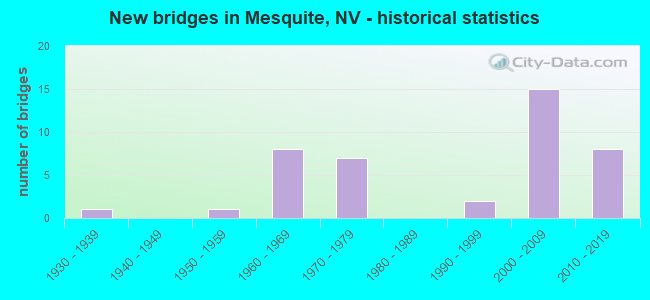
- New bridges - historical statistics
- 11930-1939
- 11950-1959
- 81960-1969
- 71970-1979
- 21990-1999
- 152000-2009
- 82010-2019

- Reconstructed bridges - Historical Statistics
- 11960-1969
- 01970-1979
- 21980-1989
- 01990-1999
- 12000-2009


- Bridge Condition - Deck
- 28.6%Very good
- 64.3%Good
- 7.1%Satisfactory

- Bridge Condition - Superstructure
- 28.6%Very good
- 64.3%Good
- 7.1%Satisfactory

- Bridge Condition - Substructure
- 28.6%Very good
- 64.3%Good
- 7.1%Satisfactory

- Bridge Condition - Channel
- 40.7%Very good
- 48.1%Good
- 7.4%Satisfactory
- 3.7%Fair

- Bridge Condition - Culverts
- 9.5%Very good
- 76.2%Good
- 14.3%Satisfactory
Find on map >> Show street view
Structure Number: B 89, Location: MESQUITE (Lat: 36.790281, Lng: -114.093850), Route carried "on" structure: State highway 170, Year Built: 2009, Status: Open, Structure Length: 28.96m (95.01ft), Average Daily Traffic: 3,900 (year 2017), Truck Traffic: 2%, Average Future Daily Traffic: 8,066 (year 2040), Design Load: HS 25 or greater, Features Intersected: VIRGIN RIVER
Minimum Vertical Clearance: 30+ m (98+ ft), Kilometerpoint: 17.732, Lanes on structure: 2, Owner: State Highway Agency, Approaching Roadway Width: 9.8m (32.2ft), Material/Design: Steel continuous, Design/Construction: Stringer/Multi-beam, Number Of Spans In Main Unit: 6, Length of Maximum Span: 50.3m (165.0ft), Curb or Sidewalk Widths: Left: 3.0m (9.8ft), Right: 0.0m, Curb-To-Curb Width: 9.8m (32.2ft), Out-to-Out Width: 14.3m (46.9ft)
Condition: Deck: Good, Superstructure: Very good, Substructure: Very good, Channel: Good, Operating Rating: 66.2 metric tons, Method Used To Determine Operating Rating: Load and Resistance Factor (LRFR), Inventory Rating: 50.9 metric tons, Method Used To Determine Inventory Rating: Load and Resistance Factor (LRFR), Structural Evaluation: Equal to present desirable criteria, Deck Geometry: Meets minimum limits, Waterway Adequacy: Better than present minimum criteria, Approach Roadway Alignment: Equal to present desirable criteria, Designated Inspection Frequency: Every 24 months, Inspection Date: December 2021, Deck Structure Type: Concrete Cast-file-Place, Wearing Surface/Protective System: Wearing Surface: Monolithic Concrete
Find on map >> Show street view
Structure Number: B 9, Location: MESQUITE (Lat: 36.803853, Lng: -114.085469), Route carried "on" structure: City street , Year Built: 1965, Year Reconstructed: 1989, Status: Open, Structure Length: 1.28m (4.20ft), Average Daily Traffic: 10,000 (year 2017), Truck Traffic: 4%, Average Future Daily Traffic: 20,681 (year 2040), Design Load: H 20, Features Intersected: ABBOTT WASH, Facility Carried by Structure: MESQUITE BLVD
Minimum Vertical Clearance: 30+ m (98+ ft), Kilometerpoint: 2.099, Lanes on structure: 4, Owner: City or Municipal Highway Agency, Approaching Roadway Width: 20.5m (67.3ft), Skew: 20 degrees, Material/Design: Concrete, Design/Construction: Culvert, Number Of Spans In Main Unit: 3, Length of Maximum Span: 4.3m (14.1ft), Curb or Sidewalk Widths: Left: 1.7m (5.6ft), Right: 1.9m (6.2ft), Curb-To-Curb Width: 20.5m (67.3ft), Out-to-Out Width: 28.7m (94.2ft)
Condition: Channel: Very good, Culverts: Good, Operating Rating: 64.8 metric tons, Method Used To Determine Operating Rating: Load Factor (LF), Inventory Rating: 38.8 metric tons, Method Used To Determine Inventory Rating: Load Factor (LF), Structural Evaluation: Better than present minimum criteria, Deck Geometry: Superior to present desirable criteria, Waterway Adequacy: Equal to present desirable criteria, Approach Roadway Alignment: Equal to present desirable criteria, Designated Inspection Frequency: Every 48 months, Inspection Date: November 2020
Find on map >> Show street view
Structure Number: B 91, Location: MESQUITE (Lat: 36.803961, Lng: -114.070119), Route carried "on" structure: City street , Year Built: 1932, Year Reconstructed: 1965, Status: Open, Structure Length: 1.46m (4.79ft), Average Daily Traffic: 11,000 (year 2017), Truck Traffic: 4%, Average Future Daily Traffic: 22,749 (year 2040), Design Load: H 20, Features Intersected: MESQUITE WASH, Facility Carried by Structure: MESQUITE BLVD
Minimum Vertical Clearance: 30+ m (98+ ft), Kilometerpoint: 3.576, Lanes on structure: 4, Owner: City or Municipal Highway Agency, Approaching Roadway Width: 15.8m (51.8ft), Skew: 24 degrees, Material/Design: Concrete, Design/Construction: Culvert, Number Of Spans In Main Unit: 3, Length of Maximum Span: 4.3m (14.1ft), Curb or Sidewalk Widths: Left: 4.2m (13.8ft), Right: 4.2m (13.8ft), Curb-To-Curb Width: 19.2m (63.0ft), Out-to-Out Width: 28.3m (92.8ft)
Condition: Channel: Good, Culverts: Good, Operating Rating: 53.9 metric tons, Method Used To Determine Operating Rating: Load Factor (LF), Inventory Rating: 32.3 metric tons, Method Used To Determine Inventory Rating: Load Factor (LF), Structural Evaluation: Better than present minimum criteria, Deck Geometry: Equal to present minimum criteria, Waterway Adequacy: Equal to present desirable criteria, Approach Roadway Alignment: Equal to present desirable criteria, Designated Inspection Frequency: Every 24 months, Inspection Date: November 2020
Find on map >> Show street view
Structure Number: B 571N, Location: WEST OF MESQUITE (Lat: 36.764278, Lng: -114.186783), Route carried "on" structure: Interstate 15, Year Built: 1954, Year Reconstructed: 1989, Status: Open, Structure Length: 7.50m (24.61ft), Average Daily Traffic: 10,500 (year 2017), Truck Traffic: 25%, Average Future Daily Traffic: 21,715 (year 2040), Design Load: HS 20, Features Intersected: TOQUOP WASH
Minimum Vertical Clearance: 30+ m (98+ ft), Kilometerpoint: 185.158, Lanes on structure: 2, Base Highway Network: Yes, Owner: State Highway Agency, Approaching Roadway Width: 12.2m (40.0ft), Skew: 2 degrees, Material/Design: Concrete continuous, Design/Construction: Tee Beam, Number Of Spans In Main Unit: 5, Length of Maximum Span: 21.9m (71.9ft), Curb-To-Curb Width: 12.8m (42.0ft), Out-to-Out Width: 13.7m (44.9ft)
Condition: Deck: Good, Superstructure: Good, Substructure: Good, Channel: Good, Operating Rating: 46.3 metric tons, Method Used To Determine Operating Rating: Load Factor (LF), Inventory Rating: 27.8 metric tons, Method Used To Determine Inventory Rating: Load Factor (LF), Structural Evaluation: Equal to present minimum criteria, Deck Geometry: Equal to present desirable criteria, Waterway Adequacy: Equal to present desirable criteria, Approach Roadway Alignment: Equal to present desirable criteria, Designated Inspection Frequency: Every 24 months, Inspection Date: December 2020, Deck Structure Type: Concrete Cast-file-Place, Wearing Surface/Protective System: Wearing Surface: Bituminous
Find on map >> Show street view
Structure Number: B 571S, Location: WEST OF MESQUITE (Lat: 36.765119, Lng: -114.187011), Route carried "on" structure: Interstate 15, Year Built: 1965, Status: Open, Structure Length: 7.44m (24.41ft), Average Daily Traffic: 10,500 (year 2017), Truck Traffic: 25%, Average Future Daily Traffic: 21,715 (year 2040), Design Load: HS 20, Features Intersected: TOQUOP WASH
Minimum Vertical Clearance: 30+ m (98+ ft), Kilometerpoint: 185.158, Lanes on structure: 2, Base Highway Network: Yes, Owner: State Highway Agency, Approaching Roadway Width: 11.6m (38.1ft), Skew: 2 degrees, Material/Design: Concrete continuous, Design/Construction: Tee Beam, Number Of Spans In Main Unit: 5, Length of Maximum Span: 20.7m (67.9ft), Curb-To-Curb Width: 12.2m (40.0ft), Out-to-Out Width: 12.9m (42.3ft)
Condition: Deck: Satisfactory, Superstructure: Good, Substructure: Satisfactory, Channel: Good, Operating Rating: 41.7 metric tons, Method Used To Determine Operating Rating: Load Factor (LF), Inventory Rating: 26.1 metric tons, Method Used To Determine Inventory Rating: Load Factor (LF), Structural Evaluation: Equal to present minimum criteria, Deck Geometry: Better than present minimum criteria, Waterway Adequacy: Equal to present desirable criteria, Approach Roadway Alignment: Equal to present desirable criteria, Designated Inspection Frequency: Every 24 months, Inspection Date: December 2020, Deck Structure Type: Concrete Cast-file-Place, Wearing Surface/Protective System: Wearing Surface: Bituminous
Find on map >> Show street view
Structure Number: B 977N, Location: NE OF MESQUITE (Lat: 36.810767, Lng: -114.067894), Route carried "on" structure: Interstate 15, Year Built: 1973, Status: Open, Structure Length: 2.13m (6.99ft), Average Daily Traffic: 9,550 (year 2017), Truck Traffic: 29%, Average Future Daily Traffic: 19,751 (year 2040), Design Load: HS 20+Mod, Features Intersected: TOWN WASH
Minimum Vertical Clearance: 30+ m (98+ ft), Kilometerpoint: 197.457, Lanes on structure: 3, Base Highway Network: Yes, Owner: State Highway Agency, Approaching Roadway Width: 14.6m (47.9ft), Skew: 2 degrees, Material/Design: Concrete, Design/Construction: Box Beam or Girders - Single/Spread, Number Of Spans In Main Unit: 1, Length of Maximum Span: 20.7m (67.9ft), Curb-To-Curb Width: 14.6m (47.9ft), Out-to-Out Width: 15.2m (49.9ft)
Condition: Deck: Very good, Superstructure: Good, Substructure: Good, Channel: Good, Operating Rating: 42.4 metric tons, Method Used To Determine Operating Rating: Load Factor (LF), Inventory Rating: 25.4 metric tons, Method Used To Determine Inventory Rating: Load Factor (LF), Structural Evaluation: Equal to present minimum criteria, Deck Geometry: Meets minimum limits, Waterway Adequacy: Equal to present desirable criteria, Approach Roadway Alignment: Equal to present desirable criteria, Designated Inspection Frequency: Every 24 months, Inspection Date: November 2020, Deck Structure Type: Concrete Cast-file-Place, Wearing Surface/Protective System: Wearing Surface: Bituminous
Find on map >> Show street view
Structure Number: B 977R, Location: NE OF MESQUITE (Lat: 36.811469, Lng: -114.067908), Route carried "on" structure: Ramp Interstate 15, Year Built: 1973, Status: Open, Structure Length: 2.19m (7.19ft), Average Daily Traffic: 2,900 (year 2017), Truck Traffic: 3%, Average Future Daily Traffic: 5,998 (year 2040), Design Load: HS 20+Mod, Features Intersected: TOWN WASH
Minimum Vertical Clearance: 30+ m (98+ ft), Kilometerpoint: 197.457, Lanes on structure: 1, Base Highway Network: Yes, Owner: State Highway Agency, Approaching Roadway Width: 6.1m (20.0ft), Skew: 2 degrees, Material/Design: Concrete, Design/Construction: Box Beam or Girders - Single/Spread, Number Of Spans In Main Unit: 1, Length of Maximum Span: 21.3m (69.9ft), Curb-To-Curb Width: 7.7m (25.3ft), Out-to-Out Width: 8.0m (26.2ft)
Condition: Deck: Good, Superstructure: Satisfactory, Substructure: Good, Channel: Good, Operating Rating: 78.4 metric tons, Method Used To Determine Operating Rating: Load Factor (LF), Inventory Rating: 47.0 metric tons, Method Used To Determine Inventory Rating: Load Factor (LF), Structural Evaluation: Equal to present minimum criteria, Deck Geometry: Better than present minimum criteria, Waterway Adequacy: Equal to present desirable criteria, Approach Roadway Alignment: Equal to present desirable criteria, Designated Inspection Frequency: Every 48 months, Inspection Date: October 2020, Deck Structure Type: Concrete Cast-file-Place, Wearing Surface/Protective System: Wearing Surface: Bituminous
Find on map >> Show street view
Structure Number: B 977S, Location: NE OF MESQUITE (Lat: 36.811158, Lng: -114.067886), Route carried "on" structure: Interstate 15, Year Built: 1973, Status: Open, Structure Length: 2.50m (8.20ft), Average Daily Traffic: 7,450 (year 2017), Truck Traffic: 29%, Average Future Daily Traffic: 15,407 (year 2040), Design Load: HS 20+Mod, Features Intersected: TOWN WASH
Minimum Vertical Clearance: 30+ m (98+ ft), Kilometerpoint: 197.457, Lanes on structure: 2, Base Highway Network: Yes, Owner: State Highway Agency, Approaching Roadway Width: 11.6m (38.1ft), Skew: 2 degrees, Material/Design: Concrete, Design/Construction: Box Beam or Girders - Single/Spread, Number Of Spans In Main Unit: 1, Length of Maximum Span: 24.4m (80.1ft), Curb-To-Curb Width: 12.8m (42.0ft), Out-to-Out Width: 13.4m (44.0ft)
Condition: Deck: Very good, Superstructure: Good, Substructure: Good, Channel: Good, Operating Rating: 42.7 metric tons, Method Used To Determine Operating Rating: Load Factor (LF), Inventory Rating: 25.8 metric tons, Method Used To Determine Inventory Rating: Load Factor (LF), Structural Evaluation: Equal to present minimum criteria, Deck Geometry: Equal to present desirable criteria, Waterway Adequacy: Equal to present desirable criteria, Approach Roadway Alignment: Equal to present desirable criteria, Designated Inspection Frequency: Every 24 months, Inspection Date: November 2020, Deck Structure Type: Concrete Cast-file-Place, Wearing Surface/Protective System: Wearing Surface: Bituminous
Find on map >> Show street view
Structure Number: B1169N, Location: SOUTHWEST OF MESQUITE (Lat: 36.777467, Lng: -114.269875), Route carried "on" structure: Interstate 15, Year Built: 1966, Status: Open, Structure Length: 0.76m (2.49ft), Average Daily Traffic: 11,500 (year 2017), Truck Traffic: 25%, Average Future Daily Traffic: 23,783 (year 2040), Design Load: HS 20, Features Intersected: DRY WASH
Minimum Vertical Clearance: 30+ m (98+ ft), Kilometerpoint: 177.448, Lanes on structure: 3, Base Highway Network: Yes, Owner: State Highway Agency, Approaching Roadway Width: 11.6m (38.1ft), Material/Design: Concrete, Design/Construction: Culvert, Number Of Spans In Main Unit: 2, Length of Maximum Span: 3.7m (12.1ft)
Condition: Channel: Good, Culverts: Satisfactory, Operating Rating: 55.6 metric tons, Method Used To Determine Operating Rating: Load Factor (LF), Inventory Rating: 33.3 metric tons, Method Used To Determine Inventory Rating: Load Factor (LF), Structural Evaluation: Equal to present minimum criteria, Waterway Adequacy: Equal to present desirable criteria, Approach Roadway Alignment: Equal to present desirable criteria, Designated Inspection Frequency: Every 48 months, Inspection Date: November 2020
Find on map >> Show street view
Structure Number: B1169S, Location: SOUTHWEST OF MESQUITE (Lat: 36.778325, Lng: -114.270133), Route carried "on" structure: Interstate 15, Year Built: 1966, Status: Open, Structure Length: 0.76m (2.49ft), Average Daily Traffic: 8,250 (year 2017), Truck Traffic: 25%, Average Future Daily Traffic: 17,062 (year 2040), Design Load: HS 20, Features Intersected: DRY WASH
Minimum Vertical Clearance: 30+ m (98+ ft), Kilometerpoint: 177.448, Lanes on structure: 3, Base Highway Network: Yes, Owner: State Highway Agency, Approaching Roadway Width: 11.6m (38.1ft), Material/Design: Concrete, Design/Construction: Culvert, Number Of Spans In Main Unit: 2, Length of Maximum Span: 3.7m (12.1ft)
Condition: Channel: Good, Culverts: Good, Operating Rating: 55.6 metric tons, Method Used To Determine Operating Rating: Load Factor (LF), Inventory Rating: 33.3 metric tons, Method Used To Determine Inventory Rating: Load Factor (LF), Structural Evaluation: Better than present minimum criteria, Waterway Adequacy: Equal to present desirable criteria, Approach Roadway Alignment: Equal to present desirable criteria, Designated Inspection Frequency: Every 48 months, Inspection Date: November 2020
Find on map >> Show street view
Structure Number: B2343, Location: MESQUITE (Lat: 36.802597, Lng: -114.072036), Route carried "on" structure: City street , Year Built: 1997, Status: Open, Structure Length: 0.77m (2.53ft), Average Daily Traffic: 275 (year 2017), Average Future Daily Traffic: 569 (year 2040), Design Load: HS 20+Mod, Features Intersected: MESQUITE WASH, Facility Carried by Structure: SOUTH FIRST STREET
Minimum Vertical Clearance: 30+ m (98+ ft), Kilometerpoint: 0.000, Lanes on structure: 2, Owner: City or Municipal Highway Agency, Approaching Roadway Width: 11.8m (38.7ft), Skew: 1 degrees, Material/Design: Concrete, Design/Construction: Culvert, Number Of Spans In Main Unit: 1, Length of Maximum Span: 7.7m (25.3ft), Curb or Sidewalk Widths: Left: 1.5m (4.9ft), Right: 1.5m (4.9ft)
Condition: Channel: Good, Culverts: Good, Inventory Rating: 54.5 metric tons, Method Used To Determine Inventory Rating: Load Factor (LF), Structural Evaluation: Better than present minimum criteria, Waterway Adequacy: Equal to present desirable criteria, Approach Roadway Alignment: Equal to present desirable criteria, Length Of Structure Improvement: 1.42m (4.66ft), Designated Inspection Frequency: Every 48 months, Inspection Date: November 2020, Bridge Improvement Cost: $138,000, Roadway Improvement Cost: $14,000, Total Project Cost: $206,000
Find on map >> Show street view
Structure Number: B2344, Location: MESQUITE (Lat: 36.805306, Lng: -114.069769), Route carried "on" structure: City street , Year Built: 1997, Status: Open, Structure Length: 0.73m (2.40ft), Average Daily Traffic: 385 (year 2017), Average Future Daily Traffic: 796 (year 2040), Design Load: HS 20+Mod, Features Intersected: MESQUITE WASH, Facility Carried by Structure: NORTH FIRST STREET
Minimum Vertical Clearance: 30+ m (98+ ft), Kilometerpoint: 0.000, Lanes on structure: 2, Owner: City or Municipal Highway Agency, Approaching Roadway Width: 19.0m (62.3ft), Material/Design: Concrete, Design/Construction: Culvert, Number Of Spans In Main Unit: 1, Length of Maximum Span: 7.3m (24.0ft), Curb or Sidewalk Widths: Left: 1.5m (4.9ft), Right: 1.5m (4.9ft)
Condition: Channel: Very good, Culverts: Good, Operating Rating: 77.0 metric tons, Method Used To Determine Operating Rating: Load Factor (LF), Inventory Rating: 46.6 metric tons, Method Used To Determine Inventory Rating: Load Factor (LF), Structural Evaluation: Better than present minimum criteria, Waterway Adequacy: Equal to present desirable criteria, Approach Roadway Alignment: Equal to present desirable criteria, Length Of Structure Improvement: 1.37m (4.49ft), Designated Inspection Frequency: Every 48 months, Inspection Date: November 2020, Bridge Improvement Cost: $214,000, Roadway Improvement Cost: $21,000, Total Project Cost: $321,000
Find on map >> Show street view
Structure Number: B2623, Location: 0.2 MILES EAST OF RIVERSI (Lat: 36.796672, Lng: -114.089067), Route carried "on" structure: City street , Year Built: 2000, Status: Open, Structure Length: 1.46m (4.79ft), Average Daily Traffic: 3,000 (year 2017), Average Future Daily Traffic: 4,900 (year 2040), Design Load: HS 20, Features Intersected: ABBOTT WASH, Facility Carried by Structure: HAFEN LN
Minimum Vertical Clearance: 30+ m (98+ ft), Kilometerpoint: 0.000, Lanes on structure: 2, Owner: City or Municipal Highway Agency, Approaching Roadway Width: 17.9m (58.7ft), Material/Design: Concrete, Design/Construction: Culvert, Number Of Spans In Main Unit: 4, Length of Maximum Span: 3.6m (11.8ft), Curb or Sidewalk Widths: Left: 1.7m (5.6ft), Right: 1.7m (5.6ft)
Condition: Channel: Very good, Culverts: Good, Inventory Rating: 85.5 metric tons, Method Used To Determine Inventory Rating: Load Factor (LF), Structural Evaluation: Better than present minimum criteria, Waterway Adequacy: Equal to present desirable criteria, Approach Roadway Alignment: Equal to present desirable criteria, Designated Inspection Frequency: Every 48 months, Inspection Date: October 2020
Find on map >> Show street view
Structure Number: B267, Location: 100 FT W OF FALCON RIDGE (Lat: 36.805633, Lng: -114.111717), Route carried "on" structure: City street , Year Built: 2000, Status: Open, Structure Length: 1.98m (6.50ft), Average Daily Traffic: 10 (year 2017), Average Future Daily Traffic: 21 (year 2040), Design Load: HS 20, Features Intersected: PULSIPHER WASH, Facility Carried by Structure: PIONEER BLVD
Minimum Vertical Clearance: 30+ m (98+ ft), Kilometerpoint: 0.000, Lanes on structure: 5, Owner: City or Municipal Highway Agency, Approaching Roadway Width: 22.5m (73.8ft), Skew: 22 degrees, Material/Design: Concrete, Design/Construction: Culvert, Number Of Spans In Main Unit: 5, Length of Maximum Span: 4.0m (13.1ft), Curb or Sidewalk Widths: Left: 0.0m, Right: 3.1m (10.2ft)
Condition: Channel: Satisfactory, Culverts: Satisfactory, Operating Rating: 81.9 metric tons, Method Used To Determine Operating Rating: Load Factor (LF), Inventory Rating: 49.3 metric tons, Method Used To Determine Inventory Rating: Load Factor (LF), Structural Evaluation: Equal to present minimum criteria, Waterway Adequacy: Equal to present desirable criteria, Approach Roadway Alignment: Equal to present desirable criteria, Designated Inspection Frequency: Every 48 months, Inspection Date: November 2020
Find on map >> Show street view
Structure Number: B2707, Location: 0.1 MILES NORTH OF I-15 I (Lat: 36.811358, Lng: -114.087211), Route carried "on" structure: City street , Year Built: 2001, Status: Open, Structure Length: 1.50m (4.92ft), Average Daily Traffic: 2,000 (year 2017), Truck Traffic: 1%, Average Future Daily Traffic: 4,136 (year 2040), Design Load: HS 20+Mod, Features Intersected: ABBOTT WASH, Facility Carried by Structure: PIONEER BLVD
Minimum Vertical Clearance: 30+ m (98+ ft), Kilometerpoint: 0.000, Lanes on structure: 6, Owner: City or Municipal Highway Agency, Approaching Roadway Width: 27.1m (88.9ft), Skew: 2 degrees, Material/Design: Concrete, Design/Construction: Culvert, Number Of Spans In Main Unit: 3, Length of Maximum Span: 4.3m (14.1ft), Curb or Sidewalk Widths: Left: 4.5m (14.8ft), Right: 1.5m (4.9ft)
Condition: Channel: Very good, Culverts: Satisfactory, Inventory Rating: 75.6 metric tons, Method Used To Determine Inventory Rating: Load Factor (LF), Structural Evaluation: Equal to present minimum criteria, Waterway Adequacy: Equal to present desirable criteria, Approach Roadway Alignment: Equal to present desirable criteria, Designated Inspection Frequency: Every 48 months, Inspection Date: October 2020
Find on map >> Show street view
Structure Number: B2715, Location: MESQUITE (Lat: 36.814172, Lng: -114.088403), Route carried "on" structure: City street , Year Built: 2001, Status: Open, Structure Length: 1.37m (4.49ft), Average Daily Traffic: 110 (year 2017), Average Future Daily Traffic: 227 (year 2040), Design Load: HS 20, Features Intersected: ABBOTT WASH, Facility Carried by Structure: FOUNTAIN VIEW LN
Minimum Vertical Clearance: 30+ m (98+ ft), Kilometerpoint: 0.000, Lanes on structure: 2, Owner: City or Municipal Highway Agency, Approaching Roadway Width: 10.6m (34.8ft), Material/Design: Concrete, Design/Construction: Culvert, Number Of Spans In Main Unit: 3, Length of Maximum Span: 4.3m (14.1ft), Curb or Sidewalk Widths: Left: 2.4m (7.9ft), Right: 0.0m
Condition: Channel: Very good, Culverts: Good, Operating Rating: 57.1 metric tons, Method Used To Determine Operating Rating: Load Factor (LF), Inventory Rating: 34.3 metric tons, Method Used To Determine Inventory Rating: Load Factor (LF), Structural Evaluation: Better than present minimum criteria, Waterway Adequacy: Equal to present desirable criteria, Approach Roadway Alignment: Equal to present desirable criteria, Designated Inspection Frequency: Every 48 months, Inspection Date: October 2020
Find on map >> Show street view
Structure Number: B2716, Location: 0.5 MILES NORTH OF I-15 (Lat: 36.817428, Lng: -114.090950), Route carried "on" structure: City street , Year Built: 2001, Status: Open, Structure Length: 1.37m (4.49ft), Average Daily Traffic: 121 (year 2017), Average Future Daily Traffic: 250 (year 2040), Design Load: HS 20, Features Intersected: ABBOTT WASH, Facility Carried by Structure: GREENS WAY
Minimum Vertical Clearance: 30+ m (98+ ft), Kilometerpoint: 0.000, Lanes on structure: 2, Owner: City or Municipal Highway Agency, Approaching Roadway Width: 7.5m (24.6ft), Material/Design: Concrete, Design/Construction: Culvert, Number Of Spans In Main Unit: 3, Length of Maximum Span: 4.3m (14.1ft)
Condition: Channel: Very good, Culverts: Good, Inventory Rating: 57.1 metric tons, Method Used To Determine Inventory Rating: Load Factor (LF), Structural Evaluation: Better than present minimum criteria, Waterway Adequacy: Equal to present desirable criteria, Approach Roadway Alignment: Equal to present desirable criteria, Designated Inspection Frequency: Every 48 months, Inspection Date: October 2020
Find on map >> Show street view
Structure Number: B273, Location: MESQUITE (Lat: 36.808986, Lng: -114.068572), Route carried "on" structure: City street , Year Built: 2000, Year Reconstructed: 2011, Status: Open, Structure Length: 1.06m (3.48ft), Average Daily Traffic: 303 (year 2017), Truck Traffic: 1%, Average Future Daily Traffic: 627 (year 2040), Design Load: HS 20, Features Intersected: CHANNEL, Facility Carried by Structure: OLD MILL RD
Minimum Vertical Clearance: 30+ m (98+ ft), Kilometerpoint: 0.000, Lanes on structure: 2, Owner: City or Municipal Highway Agency, Approaching Roadway Width: 15.0m (49.2ft), Skew: 1 degrees, Material/Design: Concrete, Design/Construction: Culvert, Number Of Spans In Main Unit: 4, Length of Maximum Span: 2.4m (7.9ft)
Condition: Channel: Very good, Culverts: Good, Structural Evaluation: Better than present minimum criteria, Waterway Adequacy: Equal to present desirable criteria, Approach Roadway Alignment: Equal to present desirable criteria, Designated Inspection Frequency: Every 48 months, Inspection Date: November 2020
Find on map >> Show street view
Structure Number: B2894, Location: MESQUITE (Lat: 36.819858, Lng: -114.092308), Route carried "on" structure: City street , Year Built: 2006, Status: Open, Structure Length: 1.37m (4.49ft), Average Daily Traffic: 1,300 (year 2017), Truck Traffic: 3%, Average Future Daily Traffic: 2,689 (year 2040), Design Load: HS 20, Features Intersected: ABBOTT WASH, Facility Carried by Structure: HARDY WY
Minimum Vertical Clearance: 30+ m (98+ ft), Kilometerpoint: 0.000, Lanes on structure: 2, Owner: City or Municipal Highway Agency, Approaching Roadway Width: 6.7m (22.0ft), Skew: 1 degrees, Material/Design: Concrete, Design/Construction: Culvert, Number Of Spans In Main Unit: 3, Length of Maximum Span: 4.4m (14.4ft), Curb or Sidewalk Widths: Left: 1.7m (5.6ft), Right: 2.6m (8.5ft)
Condition: Channel: Good, Culverts: Good, Operating Rating: 60.4 metric tons, Method Used To Determine Operating Rating: Load Factor (LF), Inventory Rating: 36.2 metric tons, Method Used To Determine Inventory Rating: Load Factor (LF), Structural Evaluation: Better than present minimum criteria, Waterway Adequacy: Equal to present desirable criteria, Approach Roadway Alignment: Equal to present desirable criteria, Designated Inspection Frequency: Every 48 months, Inspection Date: October 2020
Find on map >> Show street view
Structure Number: B2911, Location: MESQUITE (Lat: 36.808950, Lng: -114.113986), Route carried "on" structure: County highway , Year Built: 2006, Status: Open, Structure Length: 0.80m (2.62ft), Average Daily Traffic: 1,000 (year 2017), Truck Traffic: 3%, Average Future Daily Traffic: 2,068 (year 2040), Design Load: HS 20, Features Intersected: CHANNEL, Facility Carried by Structure: BERTHA HOWE LN
Minimum Vertical Clearance: 30+ m (98+ ft), Kilometerpoint: 0.000, Lanes on structure: 2, Owner: City or Municipal Highway Agency, Approaching Roadway Width: 15.3m (50.2ft), Material/Design: Concrete, Design/Construction: Culvert, Number Of Spans In Main Unit: 2, Length of Maximum Span: 3.7m (12.1ft), Curb or Sidewalk Widths: Left: 1.7m (5.6ft), Right: 0.0m
Condition: Channel: Very good, Culverts: Good, Structural Evaluation: Better than present minimum criteria, Waterway Adequacy: Equal to present desirable criteria, Approach Roadway Alignment: Equal to present desirable criteria, Designated Inspection Frequency: Every 48 months, Inspection Date: October 2020
Find on map >> Show street view
Structure Number: B2962, Location: WEST MESQUITE (Lat: 36.820200, Lng: -114.114831), Route carried "on" structure: City street , Year Built: 2009, Status: Open, Structure Length: 0.89m (2.92ft), Average Daily Traffic: 1,000 (year 2017), Average Future Daily Traffic: 2,068 (year 2040), Design Load: HS 20, Features Intersected: CHANNAL, Facility Carried by Structure: HARDY WAY
Minimum Vertical Clearance: 30+ m (98+ ft), Kilometerpoint: 0.000, Lanes on structure: 4, Owner: City or Municipal Highway Agency, Approaching Roadway Width: 22.0m (72.2ft), Skew: 20 degrees, Material/Design: Concrete, Design/Construction: Culvert, Number Of Spans In Main Unit: 2, Length of Maximum Span: 4.3m (14.1ft), Curb or Sidewalk Widths: Left: 0.0m, Right: 3.2m (10.5ft), Curb-To-Curb Width: 26.6m (87.3ft), Out-to-Out Width: 73.6m (241.5ft)
Condition: Channel: Satisfactory, Culverts: Good, Structural Evaluation: Better than present minimum criteria, Deck Geometry: Superior to present desirable criteria, Waterway Adequacy: Equal to present desirable criteria, Approach Roadway Alignment: Equal to present desirable criteria, Designated Inspection Frequency: Every 48 months, Inspection Date: October 2020
Find on map >> Show street view
Structure Number: B3126, Location: SE OF MESQUITE (Lat: 36.800317, Lng: -114.088700), Route carried "on" structure: City street , Year Built: 2005, Status: Open, Structure Length: 0.87m (2.85ft), Average Daily Traffic: 550 (year 2017), Average Future Daily Traffic: 1,137 (year 2040), Design Load: HS 20, Features Intersected: ABBOTT WASH, Facility Carried by Structure: SOUTH SECOND ST.
Minimum Vertical Clearance: 30+ m (98+ ft), Kilometerpoint: 0.000, Lanes on structure: 2, Owner: City or Municipal Highway Agency, Approaching Roadway Width: 8.2m (26.9ft), Skew: 3 degrees, Material/Design: Concrete, Design/Construction: Culvert, Number Of Spans In Main Unit: 2, Length of Maximum Span: 4.5m (14.8ft), Curb or Sidewalk Widths: Left: 1.7m (5.6ft), Right: 1.7m (5.6ft)
Condition: Channel: Good, Culverts: Good, Inventory Rating: 63.9 metric tons, Method Used To Determine Inventory Rating: Load Factor (LF), Structural Evaluation: Better than present minimum criteria, Waterway Adequacy: Equal to present desirable criteria, Approach Roadway Alignment: Better than present minimum criteria, Designated Inspection Frequency: Every 48 months, Inspection Date: Febuary 2020
Find on map >> Show street view
Structure Number: B3127, Location: SOUTHWEST OF MESQUITE (Lat: 36.796581, Lng: -114.107161), Route carried "on" structure: City street , Year Built: 2005, Status: Open, Structure Length: 1.16m (3.81ft), Average Daily Traffic: 1,500 (year 2017), Average Future Daily Traffic: 3,102 (year 2040), Design Load: HS 20, Features Intersected: PULSIPHER WASH, Facility Carried by Structure: W HAFEN LANE
Minimum Vertical Clearance: 30+ m (98+ ft), Kilometerpoint: 0.000, Lanes on structure: 2, Owner: City or Municipal Highway Agency, Approaching Roadway Width: 8.5m (27.9ft), Skew: 2 degrees, Material/Design: Concrete, Design/Construction: Culvert, Number Of Spans In Main Unit: 3, Length of Maximum Span: 3.7m (12.1ft)
Condition: Channel: Good, Culverts: Good, Operating Rating: 32.7 metric tons, Method Used To Determine Operating Rating: Field evaluation and documented engineering judgment, Inventory Rating: 19.6 metric tons, Method Used To Determine Inventory Rating: Field evaluation and documented engineering judgment, Structural Evaluation: Somewhat better than minimum adequacy, Waterway Adequacy: Better than present minimum criteria, Approach Roadway Alignment: Equal to present desirable criteria, Designated Inspection Frequency: Every 24 months, Inspection Date: December 2021
Find on map >> Show street view
Structure Number: B3128, Location: SOUTHEAST OF MESQUIT (Lat: 36.798336, Lng: -114.073242), Route carried "on" structure: City street , Year Built: 2012, Status: Open, Structure Length: 1.25m (4.10ft), Average Daily Traffic: 1,000 (year 2017), Average Future Daily Traffic: 2,068 (year 2040), Design Load: HS 20, Features Intersected: TOWN WASH CHANNEL, Facility Carried by Structure: HAFEN LANE
Minimum Vertical Clearance: 30+ m (98+ ft), Kilometerpoint: 0.000, Lanes on structure: 4, Owner: City or Municipal Highway Agency, Approaching Roadway Width: 19.5m (64.0ft), Skew: 2 degrees, Material/Design: Concrete, Design/Construction: Culvert, Number Of Spans In Main Unit: 3, Length of Maximum Span: 4.0m (13.1ft), Curb or Sidewalk Widths: Left: 1.7m (5.6ft), Right: 3.2m (10.5ft)
Condition: Channel: Very good, Culverts: Good, Operating Rating: 32.7 metric tons, Method Used To Determine Operating Rating: Field evaluation and documented engineering judgment, Inventory Rating: 19.6 metric tons, Method Used To Determine Inventory Rating: Field evaluation and documented engineering judgment, Structural Evaluation: Somewhat better than minimum adequacy, Waterway Adequacy: Equal to present desirable criteria, Approach Roadway Alignment: Equal to present desirable criteria, Designated Inspection Frequency: Every 24 months, Inspection Date: December 2021
Find on map >> Show street view
Structure Number: B3129, Location: @ W OF GRAPEVINE RD (Lat: 36.809233, Lng: -114.086172), Route carried "on" structure: City street , Year Built: 2010, Status: Open, Structure Length: 0.88m (2.89ft), Average Daily Traffic: 550 (year 2017), Average Future Daily Traffic: 1,000 (year 2040), Design Load: HS 20, Features Intersected: ABBOTT WASH, Facility Carried by Structure: WEST OLD MILL RD
Minimum Vertical Clearance: 30+ m (98+ ft), Kilometerpoint: 0.000, Lanes on structure: 2, Owner: City or Municipal Highway Agency, Approaching Roadway Width: 15.9m (52.2ft), Material/Design: Concrete, Design/Construction: Culvert, Number Of Spans In Main Unit: 2, Length of Maximum Span: 4.3m (14.1ft), Curb or Sidewalk Widths: Left: 0.0m, Right: 1.7m (5.6ft)
Condition: Channel: Very good, Culverts: Very good, Operating Rating: 32.7 metric tons, Method Used To Determine Operating Rating: Field evaluation and documented engineering judgment, Inventory Rating: 19.6 metric tons, Method Used To Determine Inventory Rating: Field evaluation and documented engineering judgment, Structural Evaluation: Somewhat better than minimum adequacy, Waterway Adequacy: Equal to present desirable criteria, Approach Roadway Alignment: Equal to present desirable criteria, Designated Inspection Frequency: Every 24 months, Inspection Date: December 2021
Find on map >> Show street view
Structure Number: B3131, Location: NORTH OF MESQUITE (Lat: 36.831086, Lng: -114.074647), Route carried "on" structure: City street , Year Built: 2010, Status: Open, Structure Length: 0.70m (2.30ft), Average Daily Traffic: 1,000 (year 2017), Average Future Daily Traffic: 2,068 (year 2040), Design Load: HS 20, Features Intersected: TOWN WASH, Facility Carried by Structure: CANYON CREST BLVD
Minimum Vertical Clearance: 30+ m (98+ ft), Kilometerpoint: 0.000, Lanes on structure: 2, Owner: City or Municipal Highway Agency, Approaching Roadway Width: 15.9m (52.2ft), Skew: 20 degrees, Material/Design: Concrete, Design/Construction: Culvert, Number Of Spans In Main Unit: 2, Length of Maximum Span: 3.4m (11.2ft), Curb or Sidewalk Widths: Left: 3.0m (9.8ft), Right: 3.0m (9.8ft)
Condition: Channel: Fair, Culverts: Good, Structural Evaluation: Better than present minimum criteria, Waterway Adequacy: Equal to present desirable criteria, Approach Roadway Alignment: Better than present minimum criteria, Designated Inspection Frequency: Every 24 months, Inspection Date: Febuary 2020
Find on map >> Show street view
Structure Number: B329, Location: Btw B2707 and B3129 (Lat: 36.809753, Lng: -114.086189), Route carried "on" structure: Interstate 15, Year Built: 2001, Status: Open, Structure Length: 0.91m (2.99ft), Average Daily Traffic: 24,000 (year 2019), Truck Traffic: 16%, Average Future Daily Traffic: 26,400 (year 2039), Design Load: HL 93, Features Intersected: Abbott Wash
Minimum Vertical Clearance: 30+ m (98+ ft), Kilometerpoint: 195.696, Lanes on structure: 4, Base Highway Network: Yes, Owner: State Highway Agency, Approaching Roadway Width: 12.2m (40.0ft), Skew: 32 degrees, Material/Design: Concrete, Design/Construction: Culvert, Number Of Spans In Main Unit: 2, Length of Maximum Span: 4.3m (14.1ft), Curb-To-Curb Width: 47.2m (154.9ft), Out-to-Out Width: 47.2m (154.9ft)
Condition: Channel: Very good, Culverts: Very good, Operating Rating: 42.4 metric tons, Method Used To Determine Operating Rating: Load and Resistance Factor (LRFR), Inventory Rating: 32.7 metric tons, Method Used To Determine Inventory Rating: Load and Resistance Factor (LRFR), Structural Evaluation: Equal to present desirable criteria, Deck Geometry: Superior to present desirable criteria, Waterway Adequacy: Equal to present desirable criteria, Approach Roadway Alignment: Equal to present desirable criteria, Designated Inspection Frequency: Every 24 months, Inspection Date: March 2021, Wearing Surface/Protective System: Wearing Surface: Bituminous
Find on map >> Show street view
Structure Number: H2731, Location: MESQUITE (Lat: 36.809650, Lng: -114.086394), Route carried "on" structure: City street , Year Built: 2005, Status: Open, Structure Length: 13.17m (43.21ft), Average Daily Traffic: 23,000 (year 2017), Truck Traffic: 2%, Average Future Daily Traffic: 34,000 (year 2040), Design Load: HS 20+Mod, Features Intersected: I 15, Facility Carried by Structure: REDD HILLS PW
Minimum Vertical Clearance: 30+ m (98+ ft), Kilometerpoint: 0.000, Lanes on structure: 4, Lanes under structure: 6, Owner: State Highway Agency, Approaching Roadway Width: 19.8m (65.0ft), Skew: 9 degrees, Material/Design: Prestressed concrete continuous, Design/Construction: Box Beam or Girders - Multiple, Number Of Spans In Main Unit: 3, Length of Maximum Span: 48.1m (157.8ft), Curb or Sidewalk Widths: Left: 1.6m (5.2ft), Right: 1.6m (5.2ft), Curb-To-Curb Width: 19.8m (65.0ft), Out-to-Out Width: 26.3m (86.3ft)
Condition: Deck: Good, Superstructure: Very good, Substructure: Very good, Inventory Rating: 59.4 metric tons, Method Used To Determine Inventory Rating: Load Factor (LF), Structural Evaluation: Equal to present desirable criteria, Deck Geometry: Better than present minimum criteria, Underclear: Equal to present minimum criteria, Approach Roadway Alignment: Better than present minimum criteria, Designated Inspection Frequency: Every 24 months, Inspection Date: December 2021, Deck Structure Type: Concrete Cast-file-Place, Wearing Surface/Protective System: Wearing Surface: Monolithic Concrete
Find on map >> Show street view
Structure Number: I 974N, Location: SOUTHWEST OF MESQUITE (Lat: 36.770344, Lng: -114.234467), Route carried "on" structure: Interstate 15, Year Built: 1966, Status: Open, Structure Length: 3.44m (11.29ft), Average Daily Traffic: 8,250 (year 2017), Truck Traffic: 25%, Average Future Daily Traffic: 35,000 (year 2040), Design Load: HS 20+Mod, Features Intersected: SR170 BUNKERVILLE RD
Minimum Vertical Clearance: 30+ m (98+ ft), Kilometerpoint: 180.823, Lanes on structure: 2, Lanes under structure: 2, Base Highway Network: Yes, Owner: State Highway Agency, Approaching Roadway Width: 11.6m (38.1ft), Skew: 2 degrees, Material/Design: Concrete continuous, Design/Construction: Slab, Number Of Spans In Main Unit: 3, Length of Maximum Span: 13.1m (43.0ft), Curb-To-Curb Width: 12.2m (40.0ft), Out-to-Out Width: 12.8m (42.0ft)
Condition: Deck: Good, Superstructure: Good, Substructure: Good, Operating Rating: 64.3 metric tons, Method Used To Determine Operating Rating: Load Factor (LF), Inventory Rating: 38.5 metric tons, Method Used To Determine Inventory Rating: Load Factor (LF), Structural Evaluation: Better than present minimum criteria, Deck Geometry: Better than present minimum criteria, Underclear: Meets minimum limits, Approach Roadway Alignment: Equal to present desirable criteria, Designated Inspection Frequency: Every 24 months, Inspection Date: November 2020, Deck Structure Type: Concrete Cast-file-Place, Wearing Surface/Protective System: Wearing Surface: Bituminous
Find on map >> Show street view
Structure Number: I 974S, Location: SOUTHWEST OF MESQUITE (Lat: 36.771103, Lng: -114.234597), Route carried "on" structure: Interstate 15, Year Built: 1966, Status: Open, Structure Length: 3.44m (11.29ft), Average Daily Traffic: 8,250 (year 2017), Truck Traffic: 25%, Average Future Daily Traffic: 17,062 (year 2040), Design Load: HS 20+Mod, Features Intersected: SR170 BUNKERVILLE RD
Minimum Vertical Clearance: 30+ m (98+ ft), Kilometerpoint: 180.823, Lanes on structure: 2, Lanes under structure: 2, Base Highway Network: Yes, Owner: State Highway Agency, Approaching Roadway Width: 11.6m (38.1ft), Skew: 2 degrees, Material/Design: Concrete continuous, Design/Construction: Slab, Number Of Spans In Main Unit: 3, Length of Maximum Span: 13.1m (43.0ft), Curb-To-Curb Width: 12.1m (39.7ft), Out-to-Out Width: 12.8m (42.0ft)
Condition: Deck: Good, Superstructure: Good, Substructure: Good, Operating Rating: 64.3 metric tons, Method Used To Determine Operating Rating: Load Factor (LF), Inventory Rating: 38.5 metric tons, Method Used To Determine Inventory Rating: Load Factor (LF), Structural Evaluation: Better than present minimum criteria, Deck Geometry: Equal to present minimum criteria, Underclear: Meets minimum limits, Approach Roadway Alignment: Equal to present desirable criteria, Designated Inspection Frequency: Every 24 months, Inspection Date: November 2020, Deck Structure Type: Concrete Cast-file-Place, Wearing Surface/Protective System: Wearing Surface: Bituminous
Find on map >> Show street view
Structure Number: I 975N, Location: MESQUITE (Lat: 36.802958, Lng: -114.107222), Route carried "on" structure: Interstate 15, Year Built: 2012, Status: Open, Structure Length: 3.46m (11.35ft), Average Daily Traffic: 10,500 (year 2017), Truck Traffic: 25%, Average Future Daily Traffic: 21,715 (year 2040), Design Load: HS 25 or greater, Features Intersected: FALCON RIDGE PKW
Minimum Vertical Clearance: 30+ m (98+ ft), Kilometerpoint: 193.746, Lanes on structure: 2, Lanes under structure: 4, Base Highway Network: Yes, Owner: State Highway Agency, Approaching Roadway Width: 12.8m (42.0ft), Skew: 3 degrees, Material/Design: Prestressed concrete, Design/Construction: Stringer/Multi-beam, Number Of Spans In Main Unit: 1, Length of Maximum Span: 34.0m (111.5ft), Curb-To-Curb Width: 12.8m (42.0ft), Out-to-Out Width: 14.0m (45.9ft)
Condition: Deck: Very good, Superstructure: Very good, Substructure: Good, Operating Rating: 67.2 metric tons, Method Used To Determine Operating Rating: Load Factor (LF), Inventory Rating: 51.9 metric tons, Method Used To Determine Inventory Rating: Load Factor (LF), Structural Evaluation: Better than present minimum criteria, Deck Geometry: Equal to present desirable criteria, Underclear: Superior to present desirable criteria, Approach Roadway Alignment: Equal to present desirable criteria, Designated Inspection Frequency: Every 24 months, Inspection Date: December 2021, Deck Structure Type: Concrete Cast-file-Place, Wearing Surface/Protective System: Wearing Surface: Latex Concrete
Find on map >> Show street view
Structure Number: I 975S, Location: MESQUITE (Lat: 36.803172, Lng: -114.107697), Route carried "on" structure: Interstate 15, Year Built: 2012, Status: Open, Structure Length: 3.55m (11.65ft), Average Daily Traffic: 10,500 (year 2017), Truck Traffic: 25%, Average Future Daily Traffic: 21,715 (year 2040), Design Load: HS 25 or greater, Features Intersected: FALCON RIDGE PKW
Minimum Vertical Clearance: 30+ m (98+ ft), Kilometerpoint: 193.746, Lanes on structure: 2, Lanes under structure: 4, Base Highway Network: Yes, Owner: State Highway Agency, Approaching Roadway Width: 12.8m (42.0ft), Skew: 3 degrees, Material/Design: Prestressed concrete, Design/Construction: Stringer/Multi-beam, Number Of Spans In Main Unit: 1, Length of Maximum Span: 34.9m (114.5ft), Curb-To-Curb Width: 12.8m (42.0ft), Out-to-Out Width: 14.0m (45.9ft)
Condition: Deck: Very good, Superstructure: Very good, Substructure: Very good, Operating Rating: 67.2 metric tons, Method Used To Determine Operating Rating: Load Factor (LF), Inventory Rating: 51.9 metric tons, Method Used To Determine Inventory Rating: Load Factor (LF), Structural Evaluation: Equal to present desirable criteria, Deck Geometry: Equal to present desirable criteria, Underclear: Superior to present desirable criteria, Approach Roadway Alignment: Equal to present desirable criteria, Designated Inspection Frequency: Every 24 months, Inspection Date: December 2021, Deck Structure Type: Concrete Cast-file-Place, Wearing Surface/Protective System: Wearing Surface: Latex Concrete
Find on map >> Show street view
Structure Number: I 978N, Location: MESQUITE (Lat: 36.812533, Lng: -114.064189), Route carried "on" structure: Interstate 15, Year Built: 1973, Status: Open, Structure Length: 3.73m (12.24ft), Average Daily Traffic: 11,000 (year 2017), Truck Traffic: 29%, Average Future Daily Traffic: 22,749 (year 2040), Design Load: HS 20+Mod, Features Intersected: Sandhill
Minimum Vertical Clearance: 30+ m (98+ ft), Kilometerpoint: 197.853, Lanes on structure: 2, Lanes under structure: 4, Base Highway Network: Yes, Owner: State Highway Agency, Approaching Roadway Width: 13.0m (42.7ft), Skew: 1 degrees, Material/Design: Concrete continuous, Design/Construction: Box Beam or Girders - Single/Spread, Number Of Spans In Main Unit: 3, Length of Maximum Span: 18.3m (60.0ft), Curb-To-Curb Width: 13.0m (42.7ft), Out-to-Out Width: 13.5m (44.3ft)
Condition: Deck: Good, Superstructure: Good, Substructure: Good, Operating Rating: 86.2 metric tons, Method Used To Determine Operating Rating: Load Factor (LF), Inventory Rating: 51.9 metric tons, Method Used To Determine Inventory Rating: Load Factor (LF), Structural Evaluation: Better than present minimum criteria, Deck Geometry: Superior to present desirable criteria, Underclear: High priority of corrective action, Approach Roadway Alignment: Equal to present desirable criteria, Designated Inspection Frequency: Every 48 months, Inspection Date: October 2020, Deck Structure Type: Concrete Cast-file-Place, Wearing Surface/Protective System: Wearing Surface: Bituminous
Find on map >> Show street view
Structure Number: I 978S, Location: MESQUITE (Lat: 36.812850, Lng: -114.064308), Route carried "on" structure: Interstate 15, Year Built: 1973, Status: Open, Structure Length: 3.73m (12.24ft), Average Daily Traffic: 11,000 (year 2017), Truck Traffic: 29%, Average Future Daily Traffic: 22,749 (year 2040), Design Load: HS 20+Mod, Features Intersected: Sandhill
Minimum Vertical Clearance: 30+ m (98+ ft), Kilometerpoint: 197.853, Lanes on structure: 2, Lanes under structure: 4, Base Highway Network: Yes, Owner: State Highway Agency, Approaching Roadway Width: 13.1m (43.0ft), Skew: 1 degrees, Material/Design: Concrete continuous, Design/Construction: Box Beam or Girders - Single/Spread, Number Of Spans In Main Unit: 3, Length of Maximum Span: 18.3m (60.0ft), Curb-To-Curb Width: 13.1m (43.0ft), Out-to-Out Width: 13.5m (44.3ft)
Condition: Deck: Good, Superstructure: Good, Substructure: Good, Operating Rating: 86.2 metric tons, Method Used To Determine Operating Rating: Load Factor (LF), Inventory Rating: 51.9 metric tons, Method Used To Determine Inventory Rating: Load Factor (LF), Structural Evaluation: Better than present minimum criteria, Deck Geometry: Superior to present desirable criteria, Underclear: High priority of corrective action, Approach Roadway Alignment: Equal to present desirable criteria, Designated Inspection Frequency: Every 48 months, Inspection Date: October 2020, Deck Structure Type: Concrete Cast-file-Place, Wearing Surface/Protective System: Wearing Surface: Bituminous
Find on map >> Show street view
Structure Number: I3154, Location: WEST OF MESQUITE (Lat: 36.782461, Lng: -114.137869), Route carried "on" structure: City street , Year Built: 2016, Status: Open, Structure Length: 6.07m (19.91ft), Average Daily Traffic: 500 (year 2017), Truck Traffic: 3%, Average Future Daily Traffic: 1,450 (year 2040), Design Load: HL 93, Features Intersected: I 15, Facility Carried by Structure: LOWER FLAT TOP DR
Minimum Vertical Clearance: 30+ m (98+ ft), Kilometerpoint: 0.000, Lanes on structure: 2, Lanes under structure: 4, Owner: State Highway Agency, Approaching Roadway Width: 19.5m (64.0ft), Material/Design: Concrete, Design/Construction: Arch - Deck, Number Of Spans In Main Unit: 2, Length of Maximum Span: 24.1m (79.1ft), Curb-To-Curb Width: 21.9m (71.9ft), Out-to-Out Width: 22.9m (75.1ft)
Condition: Deck: Good, Superstructure: Good, Substructure: Very good, Inventory Rating: 58.4 metric tons, Method Used To Determine Inventory Rating: Load and Resistance Factor (LRFR), Structural Evaluation: Better than present minimum criteria, Deck Geometry: Superior to present desirable criteria, Underclear: Equal to present desirable criteria, Approach Roadway Alignment: Better than present minimum criteria, Designated Inspection Frequency: Every 24 months, Inspection Date: October 2020
Find on map >> Show street view
Structure Number: H2731, Location: MESQUITE (Lat: 36.809650, Lng: -114.086394), Route carried "under" structure: Interstate 15, Year Built: 2005, Structure Length: 0. m, Average Daily Traffic: 18,200 (year 2009), Truck Traffic: 5%, Features Intersected: I 15, Facility Carried by Structure: REDD HILLS PW
Minimum Vertical Clearance: 6.10m (20.01ft), Kilometerpoint: 0.000, Lanes on structure: 4, Lanes under structure: 6, Material/Design: Prestressed concrete continuous, Design/Construction: Box Beam or Girders - Multiple, Length of Maximum Span: 48.1m (157.8ft)
Find on map >> Show street view
Structure Number: I 974N, Location: SOUTHWEST OF MESQUITE (Lat: 36.770344, Lng: -114.234467), Route carried "under" structure: State highway 170, Year Built: 1966, Structure Length: 0. m, Average Daily Traffic: 120 (year 2009), Truck Traffic: 3%, Features Intersected: SR170 BUNKERVILLE RD, Facility Carried by Structure: I 15N
Minimum Vertical Clearance: 4.51m (14.80ft), Kilometerpoint: 180.823, Lanes on structure: 2, Lanes under structure: 2, Material/Design: Concrete continuous, Design/Construction: Slab, Length of Maximum Span: 13.1m (43.0ft)
Find on map >> Show street view
Structure Number: I 974S, Location: SOUTHWEST OF MESQUITE (Lat: 36.771103, Lng: -114.234597), Route carried "under" structure: State highway 170, Year Built: 1966, Structure Length: 0. m, Average Daily Traffic: 120 (year 2009), Truck Traffic: 4%, Features Intersected: SR170 BUNKERVILLE RD, Facility Carried by Structure: I 15S
Minimum Vertical Clearance: 4.54m (14.90ft), Kilometerpoint: 180.823, Lanes on structure: 2, Lanes under structure: 2, Material/Design: Concrete continuous, Design/Construction: Slab, Length of Maximum Span: 13.1m (43.0ft)
Find on map >> Show street view
Structure Number: I 975N, Location: MESQUITE (Lat: 36.802958, Lng: -114.107222), Route carried "under" structure: State highway 144, Year Built: 2012, Structure Length: 0. m, Average Daily Traffic: 11,200 (year 2009), Truck Traffic: 4%, Features Intersected: SR 144 MESQUITE BL, Facility Carried by Structure: I 15N
Minimum Vertical Clearance: 5.15m (16.90ft), Kilometerpoint: 193.746, Lanes on structure: 2, Lanes under structure: 4, Material/Design: Prestressed concrete, Design/Construction: Stringer/Multi-beam, Length of Maximum Span: 34.0m (111.5ft)
Find on map >> Show street view
Structure Number: I 975S, Location: MESQUITE (Lat: 36.803172, Lng: -114.107697), Route carried "under" structure: State highway 144, Year Built: 2012, Structure Length: 0. m, Average Daily Traffic: 11,200 (year 2009), Truck Traffic: 3%, Features Intersected: SR144 MESQUITE BL, Facility Carried by Structure: I 15S
Minimum Vertical Clearance: 5.15m (16.90ft), Kilometerpoint: 193.746, Lanes on structure: 2, Lanes under structure: 4, Material/Design: Prestressed concrete, Design/Construction: Stringer/Multi-beam, Length of Maximum Span: 34.9m (114.5ft)
Find on map >> Show street view
Structure Number: I 978N, Location: MESQUITE (Lat: 36.812533, Lng: -114.064189), Route carried "under" structure: State highway 144, Year Built: 1973, Structure Length: 0. m, Average Daily Traffic: 7,650 (year 2009), Truck Traffic: 4%, Features Intersected: SR144 MESQUITE BL, Facility Carried by Structure: I 15N
Minimum Vertical Clearance: 5.33m (17.49ft), Kilometerpoint: 197.853, Lanes on structure: 2, Lanes under structure: 4, Material/Design: Concrete continuous, Design/Construction: Box Beam or Girders - Single/Spread, Length of Maximum Span: 18.3m (60.0ft)
Find on map >> Show street view
Structure Number: I 978S, Location: MESQUITE (Lat: 36.812850, Lng: -114.064308), Route carried "under" structure: State highway 144, Year Built: 1973, Structure Length: 0. m, Average Daily Traffic: 7,650 (year 2009), Truck Traffic: 3%, Features Intersected: SR144 MESQUITE BL, Facility Carried by Structure: I 15S
Minimum Vertical Clearance: 5.33m (17.49ft), Kilometerpoint: 197.853, Lanes on structure: 2, Lanes under structure: 4, Material/Design: Concrete continuous, Design/Construction: Box Beam or Girders - Single/Spread, Length of Maximum Span: 18.3m (60.0ft)