Bridge Statistics for Mesquite, Texas (TX)
Condition, Traffic, Stress, Structural Evaluation, Project Costs
- National Bridge Inventory (NBI) Statistics
- 261Number of bridges
- 4,869ft / 1,484mTotal length
- $3,312,000Total costs
- 8,938,474Total average daily traffic
- 1,030,052Total average daily truck traffic
- National Bridge Inventory (NBI) Registered Bridges for Mesquite
- No street view available for this location
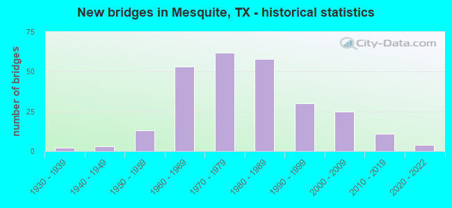
- New bridges - historical statistics
- 21930-1939
- 31940-1949
- 131950-1959
- 531960-1969
- 621970-1979
- 581980-1989
- 301990-1999
- 252000-2009
- 112010-2019
- 42020-2022

- Reconstructed bridges - Historical Statistics
- 11950-1959
- 11960-1969
- 11970-1979
- 41980-1989
- 31990-1999
- 42000-2009
- 32010-2019
- 12020-2022


- Bridge Condition - Deck
- 6.2%Very good
- 48.1%Good
- 35.7%Satisfactory
- 5.4%Fair
- 3.1%Poor
- 1.6%Serious

- Bridge Condition - Superstructure
- 17.1%Very good
- 53.5%Good
- 27.1%Satisfactory
- 2.3%Fair

- Bridge Condition - Substructure
- 2.3%Very good
- 55.8%Good
- 38.8%Satisfactory
- 3.1%Fair

- Bridge Condition - Channel
- 5.6%Very good
- 46.5%Good
- 42.4%Satisfactory
- 5.6%Fair

- Bridge Condition - Culverts
- 46.6%Good
- 50.7%Satisfactory
- 2.7%Fair
Find on map >> Show street view
Structure Number: 180570000911042, Location: 1.1 Mi. NE of IH 635 (Lat: 32.832719, Lng: -96.612572), Route carried "on" structure: City street , Year Built: 1999, Status: Open, Structure Length: 6.34m (20.80ft), Average Daily Traffic: 8,550 (year 2016), Truck Traffic: 1%, Average Future Daily Traffic: 12,058 (year 2036), Design Load: HS 20, Features Intersected: IH 30, Facility Carried by Structure: Northwest Dr. SB
Minimum Vertical Clearance: 30+ m (98+ ft), Kilometerpoint: 2.414, Lanes on structure: 4, Lanes under structure: 10, Owner: State Highway Agency, Approaching Roadway Width: 7.3m (24.0ft), Skew: 29 degrees, Material/Design: Steel continuous, Design/Construction: Stringer/Multi-beam, Number Of Spans In Main Unit: 2, Length of Maximum Span: 36.0m (118.1ft), Curb-To-Curb Width: 11.6m (38.1ft), Out-to-Out Width: 21.0m (68.9ft)
Condition: Deck: Good, Superstructure: Good, Substructure: Good, Operating Rating: 44.4 metric tons, Method Used To Determine Operating Rating: Assigned rating based on Load Factor Design (LFD) reported in metric tons, Inventory Rating: 32.7 metric tons, Method Used To Determine Inventory Rating: Assigned rating based on Load Factor Design (LFD) reported in metric tons, Structural Evaluation: Better than present minimum criteria, Deck Geometry: High priority of replacement, Underclear: Equal to present minimum criteria, Approach Roadway Alignment: Equal to present desirable criteria, Length Of Structure Improvement: 6.34m (20.80ft), Designated Inspection Frequency: Every 24 months, Inspection Date: May 2020, Bridge Improvement Cost: $16,000, Roadway Improvement Cost: $4,000, Total Project Cost: $20,000, Deck Structure Type: Concrete Cast-file-Place
Find on map >> Show street view
Structure Number: 180570000911047, Location: 0.3 Mi. S of IH 30 EBFR (Lat: 32.817389, Lng: -96.629194), Route carried "on" structure: Ramp Interstate 30, Year Built: 2011, Status: Open, Structure Length: 14.63m (48.00ft), Average Daily Traffic: 13,400 (year 2014), Truck Traffic: 3%, Average Future Daily Traffic: 18,500 (year 2034), Design Load: HS 20, Features Intersected: IH 635 SB Exit Ramp
Minimum Vertical Clearance: 30+ m (98+ ft), Kilometerpoint: 0.483, Lanes on structure: 2, Lanes under structure: 1, Owner: State Highway Agency, Approaching Roadway Width: 10.7m (35.1ft), Material/Design: Prestressed concrete, Design/Construction: Stringer/Multi-beam, Number Of Spans In Main Unit: 4, Length of Maximum Span: 36.6m (120.1ft), Curb-To-Curb Width: 10.7m (35.1ft), Out-to-Out Width: 11.6m (38.1ft)
Condition: Deck: Good, Superstructure: Good, Substructure: Good, Operating Rating: 44.4 metric tons, Method Used To Determine Operating Rating: Assigned rating based on Load Factor Design (LFD) reported in metric tons, Inventory Rating: 32.7 metric tons, Method Used To Determine Inventory Rating: Assigned rating based on Load Factor Design (LFD) reported in metric tons, Structural Evaluation: Better than present minimum criteria, Deck Geometry: Better than present minimum criteria, Underclear: Meets minimum limits, Approach Roadway Alignment: Equal to present desirable criteria, Designated Inspection Frequency: Every 24 months, Inspection Date: May 2020, Deck Structure Type: Concrete Precast Panels
Find on map >> Show street view
Structure Number: 18057000091108, Location: 0.6 Mi SW of IH 635 (Lat: 32.819119, Lng: -96.636817), Route carried "on" structure: Interstate 30, Year Built: 1948, Year Reconstructed: 1993, Status: Open, Structure Length: 2.07m (6.79ft), Average Daily Traffic: 86,851 (year 2020), Truck Traffic: 8%, Average Future Daily Traffic: 154,650 (year 2033), Design Load: H 15, Features Intersected: Mesquite Creek
Minimum Vertical Clearance: 30+ m (98+ ft), Kilometerpoint: 38.677, Lanes on structure: 10, Owner: State Highway Agency, Approaching Roadway Width: 52.4m (171.9ft), Skew: 30 degrees, Material/Design: Concrete, Design/Construction: Culvert, Number Of Spans In Main Unit: 6, Length of Maximum Span: 3.0m (9.8ft)
Condition: Channel: Good, Culverts: Fair, Operating Rating: 32.7 metric tons, Method Used To Determine Operating Rating: Field evaluation and documented engineering judgment, Inventory Rating: 24.5 metric tons, Method Used To Determine Inventory Rating: Field evaluation and documented engineering judgment, Structural Evaluation: Somewhat better than minimum adequacy, Waterway Adequacy: Superior to present desirable criteria, Approach Roadway Alignment: Equal to present desirable criteria, Designated Inspection Frequency: Every 24 months, Inspection Date: May 2020
Find on map >> Show street view
Structure Number: 180570000911197, Location: 0.9 Mi NE of LP 12 (Lat: 32.803431, Lng: -96.667986), Route carried "on" structure: City street 114, Year Built: 1960, Year Reconstructed: 2008, Status: Open, Structure Length: 9.14m (29.99ft), Average Daily Traffic: 4,400 (year 2016), Average Future Daily Traffic: 4,400 (year 2036), Design Load: HS 20, Features Intersected: IH 30, Facility Carried by Structure: Big Town Blvd NB
Minimum Vertical Clearance: 30+ m (98+ ft), Kilometerpoint: 6.920, Lanes on structure: 2, Lanes under structure: 10, Owner: State Highway Agency, Approaching Roadway Width: 6.7m (22.0ft), Skew: 1 degrees, Material/Design: Steel, Design/Construction: Stringer/Multi-beam, Number Of Spans In Main Unit: 4, Number Of Approach Spans: 2, Length of Maximum Span: 19.8m (65.0ft), Curb or Sidewalk Widths: Left: 1.5m (4.9ft), Right: 0.0m, Curb-To-Curb Width: 6.7m (22.0ft), Out-to-Out Width: 8.9m (29.2ft)
Condition: Deck: Good, Superstructure: Good, Substructure: Good, Operating Rating: 44.4 metric tons, Method Used To Determine Operating Rating: Assigned ratings based on Load and Resistance Factor Design (LRFD) reported in metric tons, Inventory Rating: 32.7 metric tons, Method Used To Determine Inventory Rating: Assigned ratings based on Load and Resistance Factor Design (LRFD) reported in metric tons, Structural Evaluation: Better than present minimum criteria, Deck Geometry: High priority of replacement, Underclear: Somewhat better than minimum adequacy, Approach Roadway Alignment: Equal to present desirable criteria, Length Of Structure Improvement: 9.14m (29.99ft), Designated Inspection Frequency: Every 24 months, Inspection Date: April 2020, Bridge Improvement Cost: $13,000, Roadway Improvement Cost: $3,000, Total Project Cost: $16,000, Deck Structure Type: Concrete Cast-file-Place
Find on map >> Show street view
Structure Number: 180570000911198, Location: 1.8 Mi. SW of IH 635 (Lat: 32.809722, Lng: -96.654539), Route carried "on" structure: City street 233, Year Built: 1960, Status: Open, Structure Length: 9.14m (29.99ft), Average Daily Traffic: 2,500 (year 2016), Average Future Daily Traffic: 2,500 (year 2036), Design Load: H 20, Features Intersected: IH 30, Facility Carried by Structure: Motley Dr. NB
Minimum Vertical Clearance: 30+ m (98+ ft), Kilometerpoint: 2.897, Lanes on structure: 2, Lanes under structure: 10, Owner: State Highway Agency, Approaching Roadway Width: 7.3m (24.0ft), Skew: 1 degrees, Material/Design: Prestressed concrete, Design/Construction: Stringer/Multi-beam, Number Of Spans In Main Unit: 4, Number Of Approach Spans: 2, Length of Maximum Span: 19.8m (65.0ft), Curb or Sidewalk Widths: Left: 1.1m (3.6ft), Right: 0.0m, Curb-To-Curb Width: 7.3m (24.0ft), Out-to-Out Width: 9.9m (32.5ft)
Condition: Deck: Satisfactory, Superstructure: Good, Substructure: Good, Operating Rating: 44.4 metric tons, Method Used To Determine Operating Rating: Load Factor (LF), Inventory Rating: 32.7 metric tons, Method Used To Determine Inventory Rating: Load Factor (LF), Structural Evaluation: Better than present minimum criteria, Deck Geometry: High priority of replacement, Underclear: Somewhat better than minimum adequacy, Approach Roadway Alignment: Equal to present desirable criteria, Length Of Structure Improvement: 9.14m (29.99ft), Designated Inspection Frequency: Every 24 months, Inspection Date: May 2020, Bridge Improvement Cost: $14,000, Roadway Improvement Cost: $4,000, Total Project Cost: $18,000, Deck Structure Type: Concrete Cast-file-Place, Wearing Surface/Protective System: Wearing Surface: Bituminous
Find on map >> Show street view
Structure Number: 180570000911199, Location: 0.7 Mi. SW of IH 635 (Lat: 32.817311, Lng: -96.638703), Route carried "on" structure: City street 112, Year Built: 1960, Status: Open, Structure Length: 9.14m (29.99ft), Average Daily Traffic: 8,040 (year 2016), Average Future Daily Traffic: 10,000 (year 2036), Design Load: H 20, Features Intersected: IH 30, Facility Carried by Structure: Gus Thomasson NB
Minimum Vertical Clearance: 30+ m (98+ ft), Kilometerpoint: 9.173, Lanes on structure: 2, Lanes under structure: 10, Owner: State Highway Agency, Approaching Roadway Width: 6.7m (22.0ft), Skew: 1 degrees, Material/Design: Prestressed concrete, Design/Construction: Stringer/Multi-beam, Number Of Spans In Main Unit: 4, Number Of Approach Spans: 2, Length of Maximum Span: 19.8m (65.0ft), Curb or Sidewalk Widths: Left: 0.0m, Right: 1.0m (3.3ft), Curb-To-Curb Width: 6.7m (22.0ft), Out-to-Out Width: 8.9m (29.2ft)
Condition: Deck: Satisfactory, Superstructure: Satisfactory, Substructure: Satisfactory, Operating Rating: 44.4 metric tons, Method Used To Determine Operating Rating: Load Factor (LF), Inventory Rating: 32.7 metric tons, Method Used To Determine Inventory Rating: Load Factor (LF), Structural Evaluation: Equal to present minimum criteria, Deck Geometry: High priority of replacement, Underclear: Somewhat better than minimum adequacy, Approach Roadway Alignment: Equal to present desirable criteria, Length Of Structure Improvement: 9.14m (29.99ft), Designated Inspection Frequency: Every 24 months, Inspection Date: May 2020, Bridge Improvement Cost: $13,000, Roadway Improvement Cost: $3,000, Total Project Cost: $16,000, Deck Structure Type: Concrete Cast-file-Place
Find on map >> Show street view
Structure Number: 180570000911304, Location: 3.5 Mi NE of US 80 (Lat: 32.820933, Lng: -96.631325), Route carried "on" structure: ServiceInterstate 30, Year Built: 1971, Status: Open, Structure Length: 0.85m (2.79ft), Average Daily Traffic: 12,000 (year 2016), Truck Traffic: 8%, Average Future Daily Traffic: 19,030 (year 2036), Features Intersected: Drainage Ditch
Minimum Vertical Clearance: 30+ m (98+ ft), Kilometerpoint: 39.390, Lanes on structure: 2, Owner: State Highway Agency, Approaching Roadway Width: 8.2m (26.9ft), Skew: 1 degrees, Material/Design: Concrete, Design/Construction: Culvert, Number Of Spans In Main Unit: 4, Length of Maximum Span: 1.8m (5.9ft)
Condition: Channel: Satisfactory, Culverts: Good, Operating Rating: 39.9 metric tons, Method Used To Determine Operating Rating: Load Factor (LF), Inventory Rating: 23.6 metric tons, Method Used To Determine Inventory Rating: Load Factor (LF), Structural Evaluation: Somewhat better than minimum adequacy, Waterway Adequacy: Superior to present desirable criteria, Approach Roadway Alignment: Equal to present desirable criteria, Designated Inspection Frequency: Every 24 months, Inspection Date: April 2020
Find on map >> Show street view
Structure Number: 180570000911305, Location: 3.5 Mi NE of US 80 (Lat: 32.823769, Lng: -96.631219), Route carried "on" structure: ServiceInterstate 30, Year Built: 1971, Status: Open, Structure Length: 0.76m (2.49ft), Average Daily Traffic: 12,000 (year 2016), Truck Traffic: 8%, Average Future Daily Traffic: 19,030 (year 2036), Features Intersected: Drainage Ditch
Minimum Vertical Clearance: 30+ m (98+ ft), Kilometerpoint: 39.574, Lanes on structure: 2, Owner: State Highway Agency, Approaching Roadway Width: 10.4m (34.1ft), Skew: 4 degrees, Material/Design: Concrete, Design/Construction: Culvert, Number Of Spans In Main Unit: 3, Length of Maximum Span: 1.5m (4.9ft)
Condition: Channel: Good, Culverts: Good, Operating Rating: 39.9 metric tons, Method Used To Determine Operating Rating: Load Factor (LF), Inventory Rating: 23.6 metric tons, Method Used To Determine Inventory Rating: Load Factor (LF), Structural Evaluation: Somewhat better than minimum adequacy, Waterway Adequacy: Superior to present desirable criteria, Approach Roadway Alignment: Equal to present desirable criteria, Designated Inspection Frequency: Every 24 months, Inspection Date: April 2020
Find on map >> Show street view
Structure Number: 180570000911351, Location: At IH 635 Interchange (Lat: 32.821756, Lng: -96.629619), Route carried "on" structure: ServiceInterstate 30, Year Built: 1971, Status: Open, Structure Length: 15.21m (49.90ft), Average Daily Traffic: 6,840 (year 2013), Truck Traffic: 8%, Average Future Daily Traffic: 9,570 (year 2033), Design Load: HS 20, Features Intersected: IH 635 & Conn. F & H
Minimum Vertical Clearance: 4.90m (16.08ft), Kilometerpoint: 39.387, Lanes on structure: 2, Lanes under structure: 10, Owner: State Highway Agency, Approaching Roadway Width: 10.4m (34.1ft), Skew: 2 degrees, Material/Design: Steel continuous, Design/Construction: Stringer/Multi-beam, Number Of Spans In Main Unit: 4, Number Of Approach Spans: 3, Length of Maximum Span: 28.0m (91.9ft), Curb-To-Curb Width: 10.1m (33.1ft), Out-to-Out Width: 10.6m (34.8ft)
Condition: Deck: Satisfactory, Superstructure: Satisfactory, Substructure: Satisfactory, Operating Rating: 44.4 metric tons, Method Used To Determine Operating Rating: Load Factor (LF), Inventory Rating: 32.7 metric tons, Method Used To Determine Inventory Rating: Load Factor (LF), Structural Evaluation: Equal to present minimum criteria, Deck Geometry: Somewhat better than minimum adequacy, Underclear: Somewhat better than minimum adequacy, Approach Roadway Alignment: Equal to present desirable criteria, Designated Inspection Frequency: Every 24 months, Inspection Date: April 2020, Deck Structure Type: Concrete Cast-file-Place
Find on map >> Show street view
Structure Number: 180570000911352, Location: At IH 635 Interchange (Lat: 32.822683, Lng: -96.630033), Route carried "on" structure: Interstate 30, Year Built: 1971, Year Reconstructed: 1998, Status: Open, Structure Length: 10.67m (35.01ft), Average Daily Traffic: 36,682 (year 2019), Truck Traffic: 8%, Average Future Daily Traffic: 77,320 (year 2033), Design Load: HS 20, Features Intersected: IH 635
Minimum Vertical Clearance: 5.41m (17.75ft), Kilometerpoint: 39.426, Lanes on structure: 3, Lanes under structure: 8, Owner: State Highway Agency, Approaching Roadway Width: 14.6m (47.9ft), Skew: 2 degrees, Material/Design: Steel continuous, Design/Construction: Stringer/Multi-beam, Number Of Spans In Main Unit: 4, Length of Maximum Span: 30.5m (100.1ft), Curb-To-Curb Width: 15.6m (51.2ft), Out-to-Out Width: 16.5m (54.1ft)
Condition: Deck: Fair, Superstructure: Satisfactory, Substructure: Satisfactory, Operating Rating: 44.4 metric tons, Method Used To Determine Operating Rating: Load Factor (LF), Inventory Rating: 32.7 metric tons, Method Used To Determine Inventory Rating: Load Factor (LF), Structural Evaluation: Equal to present minimum criteria, Deck Geometry: Somewhat better than minimum adequacy, Underclear: Somewhat better than minimum adequacy, Approach Roadway Alignment: Equal to present desirable criteria, Designated Inspection Frequency: Every 24 months, Inspection Date: April 2020, Deck Structure Type: Concrete Cast-file-Place
Find on map >> Show street view
Structure Number: 180570000911353, Location: At IH 635 Interchange (Lat: 32.823569, Lng: -96.629358), Route carried "on" structure: Interstate 30, Year Built: 1971, Year Reconstructed: 1998, Status: Open, Structure Length: 10.67m (35.01ft), Average Daily Traffic: 81,504 (year 2019), Truck Traffic: 8%, Average Future Daily Traffic: 77,320 (year 2033), Design Load: HS 20, Features Intersected: IH 635
Minimum Vertical Clearance: 5.31m (17.42ft), Kilometerpoint: 39.431, Lanes on structure: 3, Lanes under structure: 8, Owner: State Highway Agency, Approaching Roadway Width: 14.6m (47.9ft), Skew: 2 degrees, Material/Design: Steel continuous, Design/Construction: Stringer/Multi-beam, Number Of Spans In Main Unit: 4, Length of Maximum Span: 30.5m (100.1ft), Curb-To-Curb Width: 15.5m (50.9ft), Out-to-Out Width: 16.5m (54.1ft)
Condition: Deck: Poor, Superstructure: Satisfactory, Substructure: Satisfactory, Operating Rating: 44.4 metric tons, Method Used To Determine Operating Rating: Assigned ratings based on Allowable Stress Design (ASD) reported in metric tons, Inventory Rating: 32.7 metric tons, Method Used To Determine Inventory Rating: Assigned ratings based on Allowable Stress Design (ASD) reported in metric tons, Structural Evaluation: Equal to present minimum criteria, Deck Geometry: Somewhat better than minimum adequacy, Underclear: Somewhat better than minimum adequacy, Approach Roadway Alignment: Equal to present desirable criteria, Designated Inspection Frequency: Every 24 months, Inspection Date: May 2020, Deck Structure Type: Concrete Cast-file-Place
Find on map >> Show street view
Structure Number: 180570000911355, Location: IH 635 & IH 30 (Lat: 32.825144, Lng: -96.631178), Route carried "on" structure: Ramp Interstate 635, Year Built: 1971, Status: Open, Structure Length: 56.48m (185.30ft), Average Daily Traffic: 17,560 (year 2016), Truck Traffic: 10%, Average Future Daily Traffic: 24,580 (year 2036), Design Load: HS 20, Features Intersected: IH 30 to IH 635 Ramps
Minimum Vertical Clearance: 30+ m (98+ ft), Kilometerpoint: 14.824, Lanes on structure: 1, Lanes under structure: 20, Owner: State Highway Agency, Approaching Roadway Width: 8.5m (27.9ft), Material/Design: Steel continuous, Design/Construction: Stringer/Multi-beam, Number Of Spans In Main Unit: 4, Number Of Approach Spans: 21, Length of Maximum Span: 33.5m (109.9ft), Curb-To-Curb Width: 7.3m (24.0ft), Out-to-Out Width: 7.9m (25.9ft)
Condition: Deck: Satisfactory, Superstructure: Good, Substructure: Satisfactory, Operating Rating: 44.4 metric tons, Method Used To Determine Operating Rating: Assigned rating based on Load Factor Design (LFD) reported in metric tons, Inventory Rating: 32.7 metric tons, Method Used To Determine Inventory Rating: Assigned rating based on Load Factor Design (LFD) reported in metric tons, Structural Evaluation: Equal to present minimum criteria, Deck Geometry: Better than present minimum criteria, Underclear: Somewhat better than minimum adequacy, Approach Roadway Alignment: Equal to present desirable criteria, Designated Inspection Frequency: Every 24 months, Inspection Date: April 2020, Deck Structure Type: Concrete Cast-file-Place
Find on map >> Show street view
Structure Number: 180570000911356, Location: IH 635 and IH 30 (Lat: 32.821175, Lng: -96.631653), Route carried "on" structure: Ramp Interstate 30, Year Built: 1971, Status: Open, Structure Length: 64.62m (212.01ft), Average Daily Traffic: 610 (year 2013), Truck Traffic: 8%, Average Future Daily Traffic: 860 (year 2033), Design Load: HS 20, Features Intersected: IH 30
Minimum Vertical Clearance: 5.82m (19.09ft), Kilometerpoint: 39.125, Lanes on structure: 1, Lanes under structure: 18, Owner: State Highway Agency, Approaching Roadway Width: 8.5m (27.9ft), Material/Design: Steel continuous, Design/Construction: Stringer/Multi-beam, Number Of Spans In Main Unit: 4, Number Of Approach Spans: 21, Length of Maximum Span: 58.8m (192.9ft), Curb-To-Curb Width: 7.3m (24.0ft), Out-to-Out Width: 7.9m (25.9ft)
Condition: Deck: Satisfactory, Superstructure: Good, Substructure: Satisfactory, Operating Rating: 44.4 metric tons, Method Used To Determine Operating Rating: Assigned rating based on Load Factor Design (LFD) reported in metric tons, Inventory Rating: 32.7 metric tons, Method Used To Determine Inventory Rating: Assigned rating based on Load Factor Design (LFD) reported in metric tons, Structural Evaluation: Equal to present minimum criteria, Deck Geometry: Better than present minimum criteria, Underclear: High priority of corrective action, Approach Roadway Alignment: Equal to present desirable criteria, Designated Inspection Frequency: Every 24 months, Inspection Date: April 2020, Deck Structure Type: Concrete Cast-file-Place
Find on map >> Show street view
Structure Number: 180570000911357, Location: IH 635 & IH 30 (Lat: 32.824739, Lng: -96.628306), Route carried "on" structure: Ramp Interstate 30, Year Built: 1971, Status: Open, Structure Length: 57.55m (188.81ft), Average Daily Traffic: 680 (year 2013), Truck Traffic: 8%, Average Future Daily Traffic: 950 (year 2033), Design Load: HS 20, Features Intersected: IH 30
Minimum Vertical Clearance: 6.00m (19.69ft), Kilometerpoint: 39.484, Lanes on structure: 1, Lanes under structure: 18, Owner: State Highway Agency, Approaching Roadway Width: 7.9m (25.9ft), Material/Design: Steel continuous, Design/Construction: Stringer/Multi-beam, Number Of Spans In Main Unit: 4, Number Of Approach Spans: 18, Length of Maximum Span: 58.8m (192.9ft), Curb-To-Curb Width: 7.3m (24.0ft), Out-to-Out Width: 7.9m (25.9ft)
Condition: Deck: Poor, Superstructure: Good, Substructure: Fair, Operating Rating: 44.4 metric tons, Method Used To Determine Operating Rating: Assigned rating based on Load Factor Design (LFD) reported in metric tons, Inventory Rating: 32.7 metric tons, Method Used To Determine Inventory Rating: Assigned rating based on Load Factor Design (LFD) reported in metric tons, Structural Evaluation: Somewhat better than minimum adequacy, Deck Geometry: Better than present minimum criteria, Underclear: High priority of corrective action, Approach Roadway Alignment: Equal to present desirable criteria, Designated Inspection Frequency: Every 24 months, Inspection Date: April 2020, Deck Structure Type: Concrete Cast-file-Place
Find on map >> Show street view
Structure Number: 180570000911358, Location: IH 635 & IH 30 (Lat: 32.820747, Lng: -96.628317), Route carried "on" structure: Ramp Interstate 635, Year Built: 1971, Status: Open, Structure Length: 65.01m (213.29ft), Average Daily Traffic: 86,500 (year 2016), Truck Traffic: 12%, Average Future Daily Traffic: 121,100 (year 2036), Design Load: HS 20, Features Intersected: IH 30 to IH 635 Ramps
Minimum Vertical Clearance: 30+ m (98+ ft), Kilometerpoint: 14.260, Lanes on structure: 1, Lanes under structure: 20, Owner: State Highway Agency, Approaching Roadway Width: 8.5m (27.9ft), Material/Design: Steel continuous, Design/Construction: Stringer/Multi-beam, Number Of Spans In Main Unit: 4, Number Of Approach Spans: 25, Length of Maximum Span: 33.5m (109.9ft), Curb-To-Curb Width: 7.3m (24.0ft), Out-to-Out Width: 7.9m (25.9ft)
Condition: Deck: Satisfactory, Superstructure: Good, Substructure: Satisfactory, Operating Rating: 44.4 metric tons, Method Used To Determine Operating Rating: Load Factor (LF), Inventory Rating: 32.7 metric tons, Method Used To Determine Inventory Rating: Load Factor (LF), Structural Evaluation: Equal to present minimum criteria, Deck Geometry: Better than present minimum criteria, Underclear: Somewhat better than minimum adequacy, Approach Roadway Alignment: Equal to present desirable criteria, Designated Inspection Frequency: Every 24 months, Inspection Date: April 2020, Deck Structure Type: Concrete Cast-file-Place
Find on map >> Show street view
Structure Number: 180570000911359, Location: At IH 635 Interchange (Lat: 32.824681, Lng: -96.629767), Route carried "on" structure: ServiceOther road 30, Year Built: 1971, Status: Open, Structure Length: 13.75m (45.11ft), Average Daily Traffic: 6,140 (year 2013), Truck Traffic: 8%, Average Future Daily Traffic: 8,590 (year 2033), Design Load: HS 20, Features Intersected: IH 635 & Conn. E & G
Minimum Vertical Clearance: 4.93m (16.17ft), Kilometerpoint: 39.484, Lanes on structure: 2, Lanes under structure: 10, Owner: State Highway Agency, Approaching Roadway Width: 10.4m (34.1ft), Skew: 2 degrees, Material/Design: Steel continuous, Design/Construction: Stringer/Multi-beam, Number Of Spans In Main Unit: 3, Number Of Approach Spans: 4, Length of Maximum Span: 26.5m (86.9ft), Curb-To-Curb Width: 10.0m (32.8ft), Out-to-Out Width: 10.6m (34.8ft)
Condition: Deck: Satisfactory, Superstructure: Satisfactory, Substructure: Satisfactory, Operating Rating: 44.4 metric tons, Method Used To Determine Operating Rating: Assigned ratings based on Allowable Stress Design (ASD) reported in metric tons, Inventory Rating: 32.7 metric tons, Method Used To Determine Inventory Rating: Assigned ratings based on Allowable Stress Design (ASD) reported in metric tons, Structural Evaluation: Equal to present minimum criteria, Deck Geometry: Meets minimum limits, Underclear: Equal to present minimum criteria, Approach Roadway Alignment: Equal to present desirable criteria, Designated Inspection Frequency: Every 24 months, Inspection Date: May 2020, Deck Structure Type: Concrete Cast-file-Place
Find on map >> Show street view
Structure Number: 180570000911373, Location: 0.9 Mi NE of LP 12 (Lat: 32.803783, Lng: -96.668106), Route carried "on" structure: City street 114, Year Built: 1960, Year Reconstructed: 2008, Status: Open, Structure Length: 9.14m (29.99ft), Average Daily Traffic: 4,400 (year 2016), Average Future Daily Traffic: 4,400 (year 2036), Design Load: HL 93, Features Intersected: IH 30, Facility Carried by Structure: Big Town Blvd. SB
Minimum Vertical Clearance: 30+ m (98+ ft), Kilometerpoint: 6.920, Lanes on structure: 2, Lanes under structure: 10, Owner: State Highway Agency, Approaching Roadway Width: 6.7m (22.0ft), Skew: 1 degrees, Material/Design: Steel, Design/Construction: Stringer/Multi-beam, Number Of Spans In Main Unit: 4, Number Of Approach Spans: 2, Length of Maximum Span: 19.8m (65.0ft), Curb or Sidewalk Widths: Left: 0.0m, Right: 1.5m (4.9ft), Curb-To-Curb Width: 6.7m (22.0ft), Out-to-Out Width: 8.9m (29.2ft)
Condition: Deck: Good, Superstructure: Very good, Substructure: Good, Operating Rating: 44.4 metric tons, Method Used To Determine Operating Rating: Load Factor (LF), Inventory Rating: 32.7 metric tons, Method Used To Determine Inventory Rating: Load Factor (LF), Structural Evaluation: Better than present minimum criteria, Deck Geometry: High priority of replacement, Underclear: Somewhat better than minimum adequacy, Approach Roadway Alignment: Equal to present desirable criteria, Length Of Structure Improvement: 9.14m (29.99ft), Designated Inspection Frequency: Every 24 months, Inspection Date: April 2020, Bridge Improvement Cost: $13,000, Roadway Improvement Cost: $3,000, Total Project Cost: $16,000, Deck Structure Type: Concrete Cast-file-Place
Find on map >> Show street view
Structure Number: 180570000911374, Location: 1.8 Mi. SW of IH 635 (Lat: 32.810247, Lng: -96.655331), Route carried "on" structure: City street 233, Year Built: 1972, Status: Open, Structure Length: 9.14m (29.99ft), Average Daily Traffic: 2,500 (year 2016), Average Future Daily Traffic: 2,500 (year 2036), Design Load: HS 20, Features Intersected: IH 30, Facility Carried by Structure: Motley Dr. SB
Minimum Vertical Clearance: 30+ m (98+ ft), Kilometerpoint: 2.897, Lanes on structure: 2, Lanes under structure: 10, Owner: State Highway Agency, Approaching Roadway Width: 7.3m (24.0ft), Skew: 1 degrees, Material/Design: Prestressed concrete, Design/Construction: Stringer/Multi-beam, Number Of Spans In Main Unit: 4, Number Of Approach Spans: 2, Length of Maximum Span: 19.8m (65.0ft), Curb or Sidewalk Widths: Left: 0.0m, Right: 1.0m (3.3ft), Curb-To-Curb Width: 7.3m (24.0ft), Out-to-Out Width: 9.9m (32.5ft)
Condition: Deck: Good, Superstructure: Good, Substructure: Good, Operating Rating: 44.4 metric tons, Method Used To Determine Operating Rating: Assigned rating based on Load Factor Design (LFD) reported in metric tons, Inventory Rating: 32.7 metric tons, Method Used To Determine Inventory Rating: Assigned rating based on Load Factor Design (LFD) reported in metric tons, Structural Evaluation: Better than present minimum criteria, Deck Geometry: High priority of replacement, Underclear: Somewhat better than minimum adequacy, Approach Roadway Alignment: Equal to present desirable criteria, Length Of Structure Improvement: 9.14m (29.99ft), Designated Inspection Frequency: Every 24 months, Inspection Date: May 2020, Bridge Improvement Cost: $14,000, Roadway Improvement Cost: $4,000, Total Project Cost: $18,000, Deck Structure Type: Concrete Cast-file-Place
Find on map >> Show street view
Structure Number: 180570000911375, Location: 0.7 Mi. SW of IH 635 (Lat: 32.817822, Lng: -96.639486), Route carried "on" structure: City street 112, Year Built: 1960, Status: Open, Structure Length: 9.14m (29.99ft), Average Daily Traffic: 8,040 (year 2016), Average Future Daily Traffic: 10,000 (year 2036), Design Load: H 20, Features Intersected: IH 30, Facility Carried by Structure: Gus Thomasson SB
Minimum Vertical Clearance: 30+ m (98+ ft), Kilometerpoint: 9.173, Lanes on structure: 2, Lanes under structure: 10, Owner: State Highway Agency, Approaching Roadway Width: 6.7m (22.0ft), Skew: 1 degrees, Material/Design: Prestressed concrete, Design/Construction: Stringer/Multi-beam, Number Of Spans In Main Unit: 4, Number Of Approach Spans: 2, Length of Maximum Span: 19.8m (65.0ft), Curb or Sidewalk Widths: Left: 0.0m, Right: 1.0m (3.3ft), Curb-To-Curb Width: 6.7m (22.0ft), Out-to-Out Width: 8.9m (29.2ft)
Condition: Deck: Fair, Superstructure: Satisfactory, Substructure: Satisfactory, Operating Rating: 44.4 metric tons, Method Used To Determine Operating Rating: Load Factor (LF), Inventory Rating: 32.7 metric tons, Method Used To Determine Inventory Rating: Load Factor (LF), Structural Evaluation: Equal to present minimum criteria, Deck Geometry: High priority of replacement, Underclear: Somewhat better than minimum adequacy, Approach Roadway Alignment: Equal to present desirable criteria, Length Of Structure Improvement: 9.14m (29.99ft), Designated Inspection Frequency: Every 24 months, Inspection Date: May 2020, Bridge Improvement Cost: $13,000, Roadway Improvement Cost: $3,000, Total Project Cost: $16,000, Deck Structure Type: Concrete Cast-file-Place
Find on map >> Show street view
Structure Number: 180570000911453, Location: 1.1 Mi. NE of IH 635 (Lat: 32.832836, Lng: -96.612364), Route carried "on" structure: City street , Year Built: 1999, Status: Open, Structure Length: 6.34m (20.80ft), Average Daily Traffic: 8,550 (year 2016), Average Future Daily Traffic: 12,058 (year 2036), Design Load: HS 20, Features Intersected: IH 30, Facility Carried by Structure: Northwest Dr. NB
Minimum Vertical Clearance: 30+ m (98+ ft), Kilometerpoint: 2.414, Lanes on structure: 2, Lanes under structure: 9, Owner: State Highway Agency, Approaching Roadway Width: 7.3m (24.0ft), Skew: 29 degrees, Material/Design: Steel continuous, Design/Construction: Stringer/Multi-beam, Number Of Spans In Main Unit: 2, Length of Maximum Span: 36.0m (118.1ft), Curb or Sidewalk Widths: Left: 0.0m, Right: 1.8m (5.9ft), Curb-To-Curb Width: 7.9m (25.9ft), Out-to-Out Width: 14.3m (46.9ft)
Condition: Deck: Good, Superstructure: Good, Substructure: Good, Operating Rating: 44.4 metric tons, Method Used To Determine Operating Rating: Assigned rating based on Load Factor Design (LFD) reported in metric tons, Inventory Rating: 32.7 metric tons, Method Used To Determine Inventory Rating: Assigned rating based on Load Factor Design (LFD) reported in metric tons, Structural Evaluation: Better than present minimum criteria, Deck Geometry: High priority of replacement, Underclear: Equal to present minimum criteria, Approach Roadway Alignment: Equal to present desirable criteria, Length Of Structure Improvement: 6.34m (20.80ft), Designated Inspection Frequency: Every 24 months, Inspection Date: May 2020, Bridge Improvement Cost: $11,000, Roadway Improvement Cost: $3,000, Total Project Cost: $14,000, Deck Structure Type: Concrete Cast-file-Place
Find on map >> Show street view
Structure Number: 180570000911522, Location: 0.3 Mi. NE of IH 635 (Lat: 32.826381, Lng: -96.625372), Route carried "on" structure: City street , Year Built: 2021, Status: Open, Structure Length: 12.79m (41.96ft), Average Daily Traffic: 1,380 (year 2013), Average Future Daily Traffic: 1 (year 1900), Design Load: HL 93, Features Intersected: IH-30, Facility Carried by Structure: North Galloway Ave
Minimum Vertical Clearance: 30+ m (98+ ft), Kilometerpoint: 2.012, Lanes on structure: 8, Lanes under structure: 7, Owner: State Highway Agency, Approaching Roadway Width: 16.0m (52.5ft), Skew: 21 degrees, Material/Design: Prestressed concrete, Design/Construction: Stringer/Multi-beam, Number Of Spans In Main Unit: 3, Number Of Approach Spans: 1, Length of Maximum Span: 40.2m (131.9ft), Curb or Sidewalk Widths: Left: 3.7m (12.1ft), Right: 3.7m (12.1ft), Curb-To-Curb Width: 16.0m (52.5ft), Out-to-Out Width: 51.5m (169.0ft)
Condition: Deck: Very good, Superstructure: Very good, Substructure: Very good, Operating Rating: 54.4 metric tons, Method Used To Determine Operating Rating: Assigned ratings based on Load and Resistance Factor Design (LRFD) reported in metric tons, Inventory Rating: 32.7 metric tons, Method Used To Determine Inventory Rating: Assigned ratings based on Load and Resistance Factor Design (LRFD) reported in metric tons, Structural Evaluation: Equal to present desirable criteria, Deck Geometry: High priority of replacement, Underclear: High priority of corrective action, Approach Roadway Alignment: Equal to present desirable criteria, Designated Inspection Frequency: Every 24 months, Inspection Date: March 2021, Deck Structure Type: Concrete Cast-file-Place, Wearing Surface/Protective System: Deck Protection: Epoxy Coated Reinforcing
Find on map >> Show street view
Structure Number: 180570009502001, Location: 1.55 MI E of Town East (Lat: 32.792131, Lng: -96.649197), Route carried "on" structure: US 80, Year Built: 2011, Status: Open, Structure Length: 3.17m (10.40ft), Average Daily Traffic: 78,916 (year 2020), Truck Traffic: 11%, Average Future Daily Traffic: 124,000 (year 2038), Design Load: HS 20, Features Intersected: W Fork S Mesquite Creek
Minimum Vertical Clearance: 30+ m (98+ ft), Kilometerpoint: 2.897, Lanes on structure: 4, Owner: State Highway Agency, Approaching Roadway Width: 24.4m (80.1ft), Skew: 33 degrees, Material/Design: Prestressed concrete, Design/Construction: Stringer/Multi-beam, Number Of Spans In Main Unit: 1, Length of Maximum Span: 31.7m (104.0ft), Curb-To-Curb Width: 24.8m (81.4ft), Out-to-Out Width: 33.5m (109.9ft)
Condition: Deck: Satisfactory, Superstructure: Good, Substructure: Good, Channel: Very good, Operating Rating: 54.4 metric tons, Method Used To Determine Operating Rating: Assigned rating based on Load Factor Design (LFD) reported in metric tons, Inventory Rating: 32.7 metric tons, Method Used To Determine Inventory Rating: Assigned rating based on Load Factor Design (LFD) reported in metric tons, Structural Evaluation: Better than present minimum criteria, Deck Geometry: Superior to present desirable criteria, Waterway Adequacy: Superior to present desirable criteria, Approach Roadway Alignment: Equal to present desirable criteria, Designated Inspection Frequency: Every 24 months, Inspection Date: May 2020, Deck Structure Type: Concrete Precast Panels
Find on map >> Show street view
Structure Number: 180570009502002, Location: 1.00 MI WEST OH IH635 (Lat: 32.792250, Lng: -96.642783), Route carried "on" structure: US 80, Year Built: 2012, Status: Open, Structure Length: 3.05m (10.01ft), Average Daily Traffic: 78,916 (year 2020), Truck Traffic: 11%, Average Future Daily Traffic: 88,020 (year 2030), Design Load: HS 20, Features Intersected: STREAM 2B6
Minimum Vertical Clearance: 30+ m (98+ ft), Kilometerpoint: 3.476, Lanes on structure: 4, Owner: State Highway Agency, Approaching Roadway Width: 23.2m (76.1ft), Skew: 31 degrees, Material/Design: Prestressed concrete, Design/Construction: Stringer/Multi-beam, Number Of Spans In Main Unit: 1, Length of Maximum Span: 30.5m (100.1ft), Curb-To-Curb Width: 24.9m (81.7ft), Out-to-Out Width: 33.5m (109.9ft)
Condition: Deck: Satisfactory, Superstructure: Good, Substructure: Good, Channel: Very good, Operating Rating: 54.4 metric tons, Method Used To Determine Operating Rating: Assigned rating based on Load Factor Design (LFD) reported in metric tons, Inventory Rating: 32.7 metric tons, Method Used To Determine Inventory Rating: Assigned rating based on Load Factor Design (LFD) reported in metric tons, Structural Evaluation: Better than present minimum criteria, Deck Geometry: Superior to present desirable criteria, Waterway Adequacy: Superior to present desirable criteria, Approach Roadway Alignment: Equal to present desirable criteria, Designated Inspection Frequency: Every 24 months, Inspection Date: May 2020, Deck Structure Type: Concrete Precast Panels
Find on map >> Show street view
Structure Number: 180570009502003, Location: 1.00 MI WEST OF IH 635 (Lat: 32.792028, Lng: -96.642997), Route carried "on" structure: ServiceUS 80, Year Built: 2009, Status: Open, Structure Length: 3.05m (10.01ft), Average Daily Traffic: 4,736 (year 2019), Truck Traffic: 9%, Average Future Daily Traffic: 8,000 (year 2038), Design Load: HS 20, Features Intersected: STREAM 2B6
Minimum Vertical Clearance: 30+ m (98+ ft), Kilometerpoint: 3.476, Lanes on structure: 2, Owner: State Highway Agency, Approaching Roadway Width: 11.0m (36.1ft), Material/Design: Prestressed concrete, Design/Construction: Stringer/Multi-beam, Number Of Spans In Main Unit: 1, Length of Maximum Span: 30.5m (100.1ft), Curb or Sidewalk Widths: Left: 0.0m, Right: 1.8m (5.9ft), Curb-To-Curb Width: 11.0m (36.1ft), Out-to-Out Width: 13.4m (44.0ft)
Condition: Deck: Good, Superstructure: Very good, Substructure: Good, Channel: Very good, Operating Rating: 54.4 metric tons, Method Used To Determine Operating Rating: Assigned rating based on Load Factor Design (LFD) reported in metric tons, Inventory Rating: 32.7 metric tons, Method Used To Determine Inventory Rating: Assigned rating based on Load Factor Design (LFD) reported in metric tons, Structural Evaluation: Better than present minimum criteria, Deck Geometry: Equal to present minimum criteria, Waterway Adequacy: Superior to present desirable criteria, Approach Roadway Alignment: Equal to present desirable criteria, Designated Inspection Frequency: Every 24 months, Inspection Date: May 2020, Deck Structure Type: Concrete Precast Panels
Find on map >> Show street view
Structure Number: 180570009502005, Location: 1.00 MI WEST OF IH 635 (Lat: 32.792717, Lng: -96.642992), Route carried "on" structure: ServiceUS 80, Year Built: 2009, Status: Open, Structure Length: 1.16m (3.81ft), Average Daily Traffic: 3,803 (year 2019), Average Future Daily Traffic: 8,000 (year 2026), Design Load: HS 20, Features Intersected: STREAM 2B6
Minimum Vertical Clearance: 30+ m (98+ ft), Kilometerpoint: 3.476, Lanes on structure: 2, Owner: State Highway Agency, Approaching Roadway Width: 11.0m (36.1ft), Skew: 3 degrees, Material/Design: Concrete, Design/Construction: Culvert, Number Of Spans In Main Unit: 3, Length of Maximum Span: 3.0m (9.8ft), Curb or Sidewalk Widths: Left: 0.0m, Right: 1.8m (5.9ft)
Condition: Channel: Satisfactory, Culverts: Good, Operating Rating: 44.4 metric tons, Method Used To Determine Operating Rating: Assigned rating based on Load Factor Design (LFD) reported in metric tons, Inventory Rating: 32.7 metric tons, Method Used To Determine Inventory Rating: Assigned rating based on Load Factor Design (LFD) reported in metric tons, Structural Evaluation: Better than present minimum criteria, Waterway Adequacy: Better than present minimum criteria, Approach Roadway Alignment: Equal to present desirable criteria, Designated Inspection Frequency: Every 48 months, Inspection Date: July 2018
Find on map >> Show street view
Structure Number: 180570009502006, Location: 1.45 MI WEST OF IH 635 (Lat: 32.791969, Lng: -96.649056), Route carried "on" structure: ServiceUS 80, Year Built: 2009, Status: Open, Structure Length: 3.17m (10.40ft), Average Daily Traffic: 3,900 (year 2016), Truck Traffic: 9%, Average Future Daily Traffic: 8,000 (year 2038), Design Load: HS 20, Features Intersected: W FORK S MESQUITE CREEK
Minimum Vertical Clearance: 30+ m (98+ ft), Kilometerpoint: 2.897, Lanes on structure: 2, Owner: State Highway Agency, Approaching Roadway Width: 9.1m (29.9ft), Skew: 3 degrees, Material/Design: Prestressed concrete, Design/Construction: Stringer/Multi-beam, Number Of Spans In Main Unit: 1, Length of Maximum Span: 31.7m (104.0ft), Curb or Sidewalk Widths: Left: 0.0m, Right: 1.8m (5.9ft), Curb-To-Curb Width: 11.0m (36.1ft), Out-to-Out Width: 13.4m (44.0ft)
Condition: Deck: Good, Superstructure: Good, Substructure: Satisfactory, Channel: Very good, Operating Rating: 54.4 metric tons, Method Used To Determine Operating Rating: Assigned rating based on Load Factor Design (LFD) reported in metric tons, Inventory Rating: 32.7 metric tons, Method Used To Determine Inventory Rating: Assigned rating based on Load Factor Design (LFD) reported in metric tons, Structural Evaluation: Equal to present minimum criteria, Deck Geometry: Equal to present minimum criteria, Waterway Adequacy: Superior to present desirable criteria, Approach Roadway Alignment: Equal to present desirable criteria, Designated Inspection Frequency: Every 24 months, Inspection Date: May 2020, Deck Structure Type: Concrete Precast Panels
Find on map >> Show street view
Structure Number: 180570009502007, Location: 1.45 MI WEST OF IH 635 (Lat: 32.792647, Lng: -96.649561), Route carried "on" structure: ServiceUS 80, Year Built: 2009, Status: Open, Structure Length: 3.17m (10.40ft), Average Daily Traffic: 3,803 (year 2019), Truck Traffic: 9%, Average Future Daily Traffic: 7,500 (year 2038), Design Load: HS 20, Features Intersected: W FORK S MESQUIITE CREEK
Minimum Vertical Clearance: 30+ m (98+ ft), Kilometerpoint: 2.897, Lanes on structure: 2, Owner: State Highway Agency, Approaching Roadway Width: 11.0m (36.1ft), Skew: 3 degrees, Material/Design: Prestressed concrete, Design/Construction: Stringer/Multi-beam, Number Of Spans In Main Unit: 1, Length of Maximum Span: 31.7m (104.0ft), Curb or Sidewalk Widths: Left: 1.8m (5.9ft), Right: 0.0m, Curb-To-Curb Width: 11.0m (36.1ft), Out-to-Out Width: 13.4m (44.0ft)
Condition: Deck: Good, Superstructure: Good, Substructure: Good, Channel: Good, Operating Rating: 54.4 metric tons, Method Used To Determine Operating Rating: Assigned rating based on Load Factor Design (LFD) reported in metric tons, Inventory Rating: 32.7 metric tons, Method Used To Determine Inventory Rating: Assigned rating based on Load Factor Design (LFD) reported in metric tons, Structural Evaluation: Better than present minimum criteria, Deck Geometry: Equal to present minimum criteria, Waterway Adequacy: Superior to present desirable criteria, Approach Roadway Alignment: Equal to present desirable criteria, Designated Inspection Frequency: Every 24 months, Inspection Date: May 2020, Deck Structure Type: Concrete Precast Panels
Find on map >> Show street view
Structure Number: 180570009502085, Location: 0.80 MI E OF IH 635 (Lat: 32.792364, Lng: -96.612025), Route carried "on" structure: US 80, Year Built: 1955, Year Reconstructed: 1964, Status: Open, Structure Length: 5.79m (19.00ft), Average Daily Traffic: 38,900 (year 2010), Truck Traffic: 13%, Average Future Daily Traffic: 54,400 (year 2030), Design Load: H 20, Features Intersected: US 80, Facility Carried by Structure: GALLOWAY AVE
Minimum Vertical Clearance: 30+ m (98+ ft), Kilometerpoint: 6.196, Lanes on structure: 7, Lanes under structure: 4, Owner: State Highway Agency, Approaching Roadway Width: 20.1m (65.9ft), Skew: 30 degrees, Material/Design: Steel continuous, Design/Construction: Stringer/Multi-beam, Number Of Spans In Main Unit: 4, Length of Maximum Span: 16.8m (55.1ft), Curb or Sidewalk Widths: Left: 1.2m (3.9ft), Right: 1.2m (3.9ft), Curb-To-Curb Width: 23.5m (77.1ft), Out-to-Out Width: 27.2m (89.2ft)
Condition: Deck: Fair, Superstructure: Fair, Substructure: Satisfactory, Operating Rating: 39.9 metric tons, Method Used To Determine Operating Rating: Load Factor (LF), Inventory Rating: 23.6 metric tons, Method Used To Determine Inventory Rating: Load Factor (LF), Structural Evaluation: Somewhat better than minimum adequacy, Deck Geometry: High priority of replacement, Underclear: Equal to present minimum criteria, Approach Roadway Alignment: Equal to present desirable criteria, Length Of Structure Improvement: 6.77m (22.21ft), Designated Inspection Frequency: Every 24 months, Inspection Date: May 2020, Bridge Improvement Cost: $529,000, Roadway Improvement Cost: $132,000, Total Project Cost: $661,000, Deck Structure Type: Concrete Cast-file-Place
Find on map >> Show street view
Structure Number: 180570009502126, Location: 0.50 MI W OF IH 635 (Lat: 32.792006, Lng: -96.633900), Route carried "on" structure: City street 80, Year Built: 1961, Status: Open, Structure Length: 9.45m (31.00ft), Average Daily Traffic: 8,040 (year 2016), Average Future Daily Traffic: 58,520 (year 2038), Design Load: H 20, Features Intersected: US 80, Facility Carried by Structure: GROSS RD NB
Minimum Vertical Clearance: 30+ m (98+ ft), Kilometerpoint: 3.058, Lanes on structure: 2, Lanes under structure: 8, Owner: State Highway Agency, Approaching Roadway Width: 7.3m (24.0ft), Material/Design: Prestressed concrete, Design/Construction: Stringer/Multi-beam, Number Of Spans In Main Unit: 4, Number Of Approach Spans: 2, Length of Maximum Span: 19.8m (65.0ft), Curb or Sidewalk Widths: Left: 0.0m, Right: 1.1m (3.6ft), Curb-To-Curb Width: 7.3m (24.0ft), Out-to-Out Width: 9.5m (31.2ft)
Condition: Deck: Satisfactory, Superstructure: Satisfactory, Substructure: Satisfactory, Operating Rating: 68.0 metric tons, Method Used To Determine Operating Rating: Load Factor (LF), Inventory Rating: 33.6 metric tons, Method Used To Determine Inventory Rating: Load Factor (LF), Structural Evaluation: Equal to present minimum criteria, Deck Geometry: High priority of replacement, Underclear: High priority of corrective action, Approach Roadway Alignment: Equal to present desirable criteria, Length Of Structure Improvement: 9.45m (31.00ft), Designated Inspection Frequency: Every 24 months, Inspection Date: May 2020, Bridge Improvement Cost: $15,000, Roadway Improvement Cost: $4,000, Total Project Cost: $19,000, Deck Structure Type: Concrete Cast-file-Place, Wearing Surface/Protective System: Wearing Surface: Bituminous
Find on map >> Show street view
Structure Number: 180570009502138, Location: 0.15 MI W OF IH 635 (Lat: 32.793428, Lng: -96.628133), Route carried "on" structure: ServiceUS 80, Year Built: 1971, Status: Open, Structure Length: 2.93m (9.61ft), Average Daily Traffic: 1,540 (year 2013), Truck Traffic: 10%, Average Future Daily Traffic: 2,150 (year 2033), Design Load: H 20, Features Intersected: S MESQUITE CREEK
Minimum Vertical Clearance: 30+ m (98+ ft), Kilometerpoint: 5.060, Lanes on structure: 2, Owner: State Highway Agency, Approaching Roadway Width: 11.0m (36.1ft), Skew: 1 degrees, Material/Design: Prestressed concrete, Design/Construction: Stringer/Multi-beam, Number Of Spans In Main Unit: 2, Length of Maximum Span: 14.6m (47.9ft), Curb or Sidewalk Widths: Left: 1.4m (4.6ft), Right: 0.0m, Curb-To-Curb Width: 9.1m (29.9ft), Out-to-Out Width: 11.1m (36.4ft)
Condition: Deck: Good, Superstructure: Very good, Substructure: Good, Channel: Satisfactory, Operating Rating: 61.7 metric tons, Method Used To Determine Operating Rating: Load Factor (LF), Inventory Rating: 29.9 metric tons, Method Used To Determine Inventory Rating: Load Factor (LF), Structural Evaluation: Better than present minimum criteria, Deck Geometry: Meets minimum limits, Waterway Adequacy: Better than present minimum criteria, Approach Roadway Alignment: Equal to present desirable criteria, Length Of Structure Improvement: 2.93m (9.61ft), Designated Inspection Frequency: Every 24 months, Inspection Date: May 2020, Bridge Improvement Cost: $6,000, Roadway Improvement Cost: $2,000, Total Project Cost: $8,000, Deck Structure Type: Concrete Cast-file-Place
Find on map >> Show street view
Structure Number: 180570009502139, Location: 0.15 MI W OF IH 635 (Lat: 32.792489, Lng: -96.627703), Route carried "on" structure: US 80, Year Built: 1971, Status: Open, Structure Length: 3.57m (11.71ft), Average Daily Traffic: 40,427 (year 2019), Truck Traffic: 10%, Average Future Daily Traffic: 47,140 (year 2033), Design Load: HS 20, Features Intersected: S MESQUITE CREEK
Minimum Vertical Clearance: 30+ m (98+ ft), Kilometerpoint: 4.907, Lanes on structure: 3, Owner: State Highway Agency, Approaching Roadway Width: 12.2m (40.0ft), Material/Design: Prestressed concrete, Design/Construction: Stringer/Multi-beam, Number Of Spans In Main Unit: 2, Length of Maximum Span: 18.6m (61.0ft), Curb-To-Curb Width: 19.1m (62.7ft), Out-to-Out Width: 19.7m (64.6ft)
Condition: Deck: Very good, Superstructure: Good, Substructure: Good, Channel: Good, Operating Rating: 54.4 metric tons, Method Used To Determine Operating Rating: Assigned rating based on Load Factor Design (LFD) reported in metric tons, Inventory Rating: 32.7 metric tons, Method Used To Determine Inventory Rating: Assigned rating based on Load Factor Design (LFD) reported in metric tons, Structural Evaluation: Better than present minimum criteria, Deck Geometry: Superior to present desirable criteria, Waterway Adequacy: Better than present minimum criteria, Approach Roadway Alignment: Equal to present desirable criteria, Designated Inspection Frequency: Every 24 months, Inspection Date: May 2020, Deck Structure Type: Concrete Cast-file-Place, Wearing Surface/Protective System: Wearing Surface: Bituminous
Find on map >> Show street view
Structure Number: 18057000950214, Location: 0.15 MI W OF IH 635 (Lat: 32.792236, Lng: -96.627675), Route carried "on" structure: US 80, Year Built: 1971, Status: Open, Structure Length: 3.57m (11.71ft), Average Daily Traffic: 42,642 (year 2019), Truck Traffic: 10%, Average Future Daily Traffic: 47,140 (year 2033), Design Load: HS 20, Features Intersected: S MESQUITE CREEK
Minimum Vertical Clearance: 30+ m (98+ ft), Kilometerpoint: 4.907, Lanes on structure: 3, Owner: State Highway Agency, Approaching Roadway Width: 14.6m (47.9ft), Material/Design: Prestressed concrete, Design/Construction: Stringer/Multi-beam, Number Of Spans In Main Unit: 2, Length of Maximum Span: 18.6m (61.0ft), Curb-To-Curb Width: 16.5m (54.1ft), Out-to-Out Width: 17.0m (55.8ft)
Condition: Deck: Good, Superstructure: Good, Substructure: Good, Channel: Satisfactory, Operating Rating: 54.4 metric tons, Method Used To Determine Operating Rating: Assigned rating based on Load Factor Design (LFD) reported in metric tons, Inventory Rating: 32.7 metric tons, Method Used To Determine Inventory Rating: Assigned rating based on Load Factor Design (LFD) reported in metric tons, Structural Evaluation: Better than present minimum criteria, Deck Geometry: Equal to present minimum criteria, Waterway Adequacy: Better than present minimum criteria, Approach Roadway Alignment: Equal to present desirable criteria, Designated Inspection Frequency: Every 24 months, Inspection Date: May 2020, Deck Structure Type: Concrete Cast-file-Place, Wearing Surface/Protective System: Wearing Surface: Bituminous
Find on map >> Show street view
Structure Number: 180570009502141, Location: 0.15 MI W OF IH 635 (Lat: 32.791444, Lng: -96.627694), Route carried "on" structure: ServiceUS 80, Year Built: 1971, Status: Open, Structure Length: 3.23m (10.60ft), Average Daily Traffic: 1,470 (year 2013), Truck Traffic: 10%, Average Future Daily Traffic: 2,070 (year 2033), Design Load: H 20, Features Intersected: S MESQUITE CREEK
Minimum Vertical Clearance: 30+ m (98+ ft), Kilometerpoint: 5.060, Lanes on structure: 2, Owner: State Highway Agency, Approaching Roadway Width: 9.1m (29.9ft), Skew: 1 degrees, Material/Design: Prestressed concrete, Design/Construction: Stringer/Multi-beam, Number Of Spans In Main Unit: 2, Length of Maximum Span: 15.9m (52.2ft), Curb or Sidewalk Widths: Left: 1.4m (4.6ft), Right: 0.0m, Curb-To-Curb Width: 9.1m (29.9ft), Out-to-Out Width: 11.1m (36.4ft)
Condition: Deck: Good, Superstructure: Good, Substructure: Good, Channel: Satisfactory, Operating Rating: 54.4 metric tons, Method Used To Determine Operating Rating: Load Factor (LF), Inventory Rating: 21.8 metric tons, Method Used To Determine Inventory Rating: Load Factor (LF), Structural Evaluation: Somewhat better than minimum adequacy, Deck Geometry: Meets minimum limits, Waterway Adequacy: Better than present minimum criteria, Approach Roadway Alignment: Equal to present desirable criteria, Length Of Structure Improvement: 3.23m (10.60ft), Designated Inspection Frequency: Every 24 months, Inspection Date: May 2020, Bridge Improvement Cost: $6,000, Roadway Improvement Cost: $2,000, Total Project Cost: $8,000, Deck Structure Type: Concrete Cast-file-Place
Find on map >> Show street view
Structure Number: 180570009502146, Location: 0.35 MI E OF IH 635 (Lat: 32.792247, Lng: -96.619142), Route carried "on" structure: US 80, Year Built: 1971, Year Reconstructed: 2018, Status: Open, Structure Length: 0.67m (2.20ft), Average Daily Traffic: 66,511 (year 2020), Truck Traffic: 12%, Average Future Daily Traffic: 86,780 (year 2033), Design Load: HS 20, Features Intersected: DRAW
Minimum Vertical Clearance: 30+ m (98+ ft), Kilometerpoint: 5.708, Lanes on structure: 10, Owner: State Highway Agency, Approaching Roadway Width: 44.5m (146.0ft), Skew: 30 degrees, Material/Design: Concrete, Design/Construction: Culvert, Number Of Spans In Main Unit: 3, Length of Maximum Span: 2.1m (6.9ft)
Condition: Channel: Satisfactory, Culverts: Satisfactory, Operating Rating: 39.9 metric tons, Method Used To Determine Operating Rating: Load Factor (LF), Inventory Rating: 23.6 metric tons, Method Used To Determine Inventory Rating: Load Factor (LF), Structural Evaluation: Somewhat better than minimum adequacy, Waterway Adequacy: Equal to present minimum criteria, Approach Roadway Alignment: Equal to present desirable criteria, Designated Inspection Frequency: Every 24 months, Inspection Date: May 2020, Deck Structure Type: Concrete Cast-file-Place, Wearing Surface/Protective System: Wearing Surface: Bituminous
Find on map >> Show street view
Structure Number: 180570009502213, Location: 2.00 MI E OF IH 635 (Lat: 32.789764, Lng: -96.592992), Route carried "on" structure: ServiceUS 80, Year Built: 2006, Status: Open, Structure Length: 5.79m (19.00ft), Average Daily Traffic: 10,980 (year 2013), Truck Traffic: 12%, Average Future Daily Traffic: 15,370 (year 2033), Design Load: HS 20, Features Intersected: NORTH MESQUITE CREEK
Minimum Vertical Clearance: 30+ m (98+ ft), Kilometerpoint: 8.142, Lanes on structure: 2, Owner: State Highway Agency, Approaching Roadway Width: 9.1m (29.9ft), Material/Design: Prestressed concrete, Design/Construction: Stringer/Multi-beam, Number Of Spans In Main Unit: 3, Length of Maximum Span: 21.3m (69.9ft), Curb-To-Curb Width: 8.8m (28.9ft), Out-to-Out Width: 9.8m (32.2ft)
Condition: Deck: Satisfactory, Superstructure: Good, Substructure: Good, Channel: Good, Operating Rating: 54.4 metric tons, Method Used To Determine Operating Rating: Assigned rating based on Load Factor Design (LFD) reported in metric tons, Inventory Rating: 32.7 metric tons, Method Used To Determine Inventory Rating: Assigned rating based on Load Factor Design (LFD) reported in metric tons, Structural Evaluation: Better than present minimum criteria, Deck Geometry: High priority of corrective action, Waterway Adequacy: Superior to present desirable criteria, Approach Roadway Alignment: Equal to present desirable criteria, Designated Inspection Frequency: Every 24 months, Inspection Date: May 2020, Deck Structure Type: Concrete Precast Panels
Find on map >> Show street view
Structure Number: 180570009502214, Location: 2.00 MI E OF IH 635 (Lat: 32.789881, Lng: -96.593192), Route carried "on" structure: US 80, Year Built: 1999, Status: Open, Structure Length: 6.40m (21.00ft), Average Daily Traffic: 66,511 (year 2020), Truck Traffic: 12%, Average Future Daily Traffic: 86,780 (year 2033), Design Load: HS 20, Features Intersected: N MESQUITE CREEK
Minimum Vertical Clearance: 30+ m (98+ ft), Kilometerpoint: 8.188, Lanes on structure: 4, Owner: State Highway Agency, Approaching Roadway Width: 23.2m (76.1ft), Skew: 30 degrees, Material/Design: Prestressed concrete, Design/Construction: Stringer/Multi-beam, Number Of Spans In Main Unit: 3, Length of Maximum Span: 22.9m (75.1ft), Curb-To-Curb Width: 35.5m (116.5ft), Out-to-Out Width: 37.2m (122.0ft)
Condition: Deck: Good, Superstructure: Good, Substructure: Good, Channel: Satisfactory, Operating Rating: 54.4 metric tons, Method Used To Determine Operating Rating: Assigned rating based on Load Factor Design (LFD) reported in metric tons, Inventory Rating: 32.7 metric tons, Method Used To Determine Inventory Rating: Assigned rating based on Load Factor Design (LFD) reported in metric tons, Structural Evaluation: Better than present minimum criteria, Deck Geometry: Superior to present desirable criteria, Waterway Adequacy: Superior to present desirable criteria, Approach Roadway Alignment: Equal to present desirable criteria, Designated Inspection Frequency: Every 24 months, Inspection Date: May 2020, Deck Structure Type: Concrete Precast Panels
Find on map >> Show street view
Structure Number: 180570009502216, Location: 2.00 MI EAST OF IH 635 (Lat: 32.790428, Lng: -96.593308), Route carried "on" structure: ServiceUS 80, Year Built: 2006, Status: Open, Structure Length: 7.62m (25.00ft), Average Daily Traffic: 2,190 (year 2013), Truck Traffic: 12%, Average Future Daily Traffic: 3,070 (year 2033), Design Load: HS 20, Features Intersected: NORTH MESQUITE CREEK
Minimum Vertical Clearance: 30+ m (98+ ft), Kilometerpoint: 8.119, Lanes on structure: 2, Owner: State Highway Agency, Approaching Roadway Width: 9.1m (29.9ft), Material/Design: Prestressed concrete, Design/Construction: Stringer/Multi-beam, Number Of Spans In Main Unit: 3, Length of Maximum Span: 27.4m (89.9ft), Curb-To-Curb Width: 8.9m (29.2ft), Out-to-Out Width: 9.8m (32.2ft)
Condition: Deck: Satisfactory, Superstructure: Good, Substructure: Satisfactory, Channel: Good, Operating Rating: 54.4 metric tons, Method Used To Determine Operating Rating: Assigned rating based on Load Factor Design (LFD) reported in metric tons, Inventory Rating: 32.7 metric tons, Method Used To Determine Inventory Rating: Assigned rating based on Load Factor Design (LFD) reported in metric tons, Structural Evaluation: Equal to present minimum criteria, Deck Geometry: High priority of corrective action, Waterway Adequacy: Superior to present desirable criteria, Approach Roadway Alignment: Equal to present desirable criteria, Length Of Structure Improvement: 6.10m (20.01ft), Designated Inspection Frequency: Every 24 months, Inspection Date: May 2020, Bridge Improvement Cost: $4,000, Roadway Improvement Cost: $1,000, Total Project Cost: $210,000, Deck Structure Type: Concrete Precast Panels
Find on map >> Show street view
Structure Number: 180570009502245, Location: 1.80 MI E OF IH 635 (Lat: 32.790392, Lng: -96.596147), Route carried "on" structure: US 80, Year Built: 1999, Status: Open, Structure Length: 7.32m (24.02ft), Average Daily Traffic: 66,511 (year 2020), Truck Traffic: 12%, Average Future Daily Traffic: 86,780 (year 2033), Design Load: HS 20, Features Intersected: BELT LINE RD
Minimum Vertical Clearance: 30+ m (98+ ft), Kilometerpoint: 7.900, Lanes on structure: 4, Lanes under structure: 7, Owner: State Highway Agency, Approaching Roadway Width: 23.2m (76.1ft), Skew: 31 degrees, Material/Design: Prestressed concrete, Design/Construction: Stringer/Multi-beam, Number Of Spans In Main Unit: 1, Number Of Approach Spans: 2, Length of Maximum Span: 33.5m (109.9ft), Curb-To-Curb Width: 35.8m (117.5ft), Out-to-Out Width: 37.2m (122.0ft)
Condition: Deck: Good, Superstructure: Very good, Substructure: Good, Operating Rating: 54.4 metric tons, Method Used To Determine Operating Rating: Assigned rating based on Load Factor Design (LFD) reported in metric tons, Inventory Rating: 32.7 metric tons, Method Used To Determine Inventory Rating: Assigned rating based on Load Factor Design (LFD) reported in metric tons, Structural Evaluation: Better than present minimum criteria, Deck Geometry: Superior to present desirable criteria, Underclear: Meets minimum limits, Approach Roadway Alignment: Equal to present desirable criteria, Designated Inspection Frequency: Every 24 months, Inspection Date: May 2020, Deck Structure Type: Concrete Precast Panels
Find on map >> Show street view
Structure Number: 180570009502331, Location: US 80 & IH 635 INTRCHANGE (Lat: 32.790422, Lng: -96.625692), Route carried "on" structure: Ramp US 80, Year Built: 1971, Status: Open, Structure Length: 41.67m (136.71ft), Average Daily Traffic: 62,860 (year 2010), Truck Traffic: 11%, Average Future Daily Traffic: 88,020 (year 2030), Design Load: HS 20, Features Intersected: US 80
Minimum Vertical Clearance: 5.13m (16.83ft), Kilometerpoint: 5.150, Lanes on structure: 1, Lanes under structure: 10, Owner: State Highway Agency, Approaching Roadway Width: 7.3m (24.0ft), Material/Design: Steel continuous, Design/Construction: Stringer/Multi-beam, Number Of Spans In Main Unit: 4, Number Of Approach Spans: 13, Length of Maximum Span: 39.9m (130.9ft), Curb-To-Curb Width: 7.3m (24.0ft), Out-to-Out Width: 7.9m (25.9ft)
Condition: Deck: Poor, Superstructure: Good, Substructure: Satisfactory, Operating Rating: 54.4 metric tons, Method Used To Determine Operating Rating: Assigned rating based on Load Factor Design (LFD) reported in metric tons, Inventory Rating: 32.7 metric tons, Method Used To Determine Inventory Rating: Assigned rating based on Load Factor Design (LFD) reported in metric tons, Structural Evaluation: Equal to present minimum criteria, Deck Geometry: Better than present minimum criteria, Underclear: High priority of corrective action, Approach Roadway Alignment: Equal to present desirable criteria, Designated Inspection Frequency: Every 24 months, Inspection Date: May 2020, Deck Structure Type: Concrete Cast-file-Place
Find on map >> Show street view
Structure Number: 180570009502332, Location: US 80 & IH 635 INTRCHANGE (Lat: 32.791781, Lng: -96.627353), Route carried "on" structure: Ramp US 80, Year Built: 1971, Status: Open, Structure Length: 49.71m (163.09ft), Average Daily Traffic: 62,860 (year 2010), Truck Traffic: 11%, Average Future Daily Traffic: 88,020 (year 2030), Design Load: HS 20, Features Intersected: US 80
Minimum Vertical Clearance: 5.49m (18.01ft), Kilometerpoint: 5.150, Lanes on structure: 1, Lanes under structure: 8, Owner: State Highway Agency, Approaching Roadway Width: 7.3m (24.0ft), Material/Design: Steel continuous, Design/Construction: Stringer/Multi-beam, Number Of Spans In Main Unit: 4, Number Of Approach Spans: 17, Length of Maximum Span: 39.6m (129.9ft), Curb-To-Curb Width: 7.3m (24.0ft), Out-to-Out Width: 7.9m (25.9ft)
Condition: Deck: Poor, Superstructure: Good, Substructure: Satisfactory, Channel: Good, Operating Rating: 54.4 metric tons, Method Used To Determine Operating Rating: Assigned rating based on Load Factor Design (LFD) reported in metric tons, Inventory Rating: 32.7 metric tons, Method Used To Determine Inventory Rating: Assigned rating based on Load Factor Design (LFD) reported in metric tons, Structural Evaluation: Equal to present minimum criteria, Deck Geometry: Better than present minimum criteria, Underclear: Meets minimum limits, Waterway Adequacy: Superior to present desirable criteria, Approach Roadway Alignment: Equal to present desirable criteria, Designated Inspection Frequency: Every 24 months, Inspection Date: May 2020, Deck Structure Type: Concrete Cast-file-Place