Bridge Statistics for Missouri City, Texas (TX)
Condition, Traffic, Stress, Structural Evaluation, Project Costs
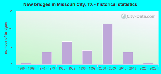
- New bridges - historical statistics
- 11960-1969
- 71970-1979
- 131980-1989
- 81990-1999
- 232000-2009
- 72010-2019
- 12020-2022
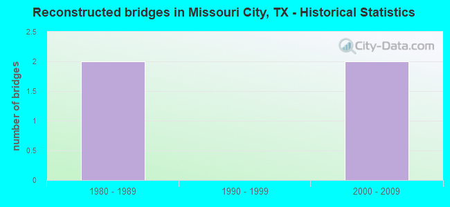
- Reconstructed bridges - Historical Statistics
- 21980-1989
- 01990-1999
- 22000-2009
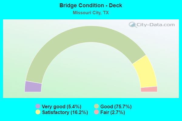
- Bridge Condition - Deck
- 5.4%Very good
- 75.7%Good
- 16.2%Satisfactory
- 2.7%Fair
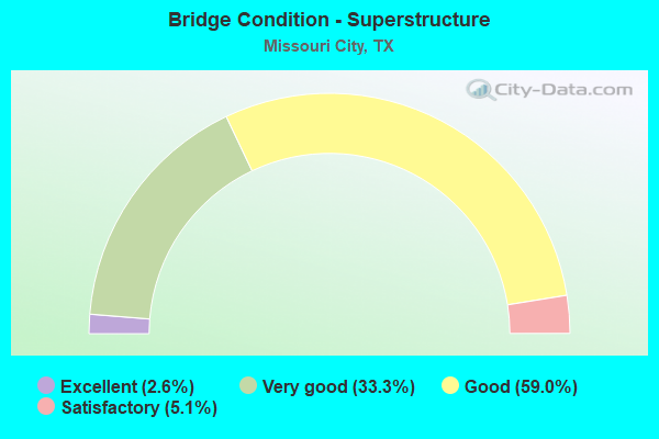
- Bridge Condition - Superstructure
- 2.6%Excellent
- 33.3%Very good
- 59.0%Good
- 5.1%Satisfactory
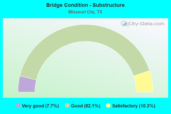
- Bridge Condition - Substructure
- 7.7%Very good
- 82.1%Good
- 10.3%Satisfactory
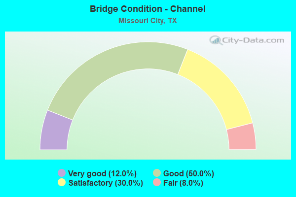
- Bridge Condition - Channel
- 12.0%Very good
- 50.0%Good
- 30.0%Satisfactory
- 8.0%Fair
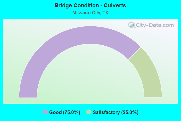
- Bridge Condition - Culverts
- 75.0%Good
- 25.0%Satisfactory
Find on map >> Show street view
Structure Number: 120800002708031, Location: 1.2 Mi SW of BW 8 (Lat: 29.618881, Lng: -95.538158), Route carried "on" structure: Alternate State highway 90, Year Built: 2008, Status: Open, Structure Length: 35.63m (116.90ft), Average Daily Traffic: 79,622 (year 2018), Truck Traffic: 10%, Average Future Daily Traffic: 26,500 (year 2034), Design Load: HS 20, Features Intersected: S Gessner Rd
Minimum Vertical Clearance: 30+ m (98+ ft), Kilometerpoint: 0.002, Lanes on structure: 6, Lanes under structure: 8, Owner: State Highway Agency, Approaching Roadway Width: 23.8m (78.1ft), Skew: 29 degrees, Material/Design: Steel continuous, Design/Construction: Orthotropic, Number Of Spans In Main Unit: 2, Number Of Approach Spans: 9, Length of Maximum Span: 44.5m (146.0ft), Curb-To-Curb Width: 23.8m (78.1ft), Out-to-Out Width: 28.6m (93.8ft)
Condition: Deck: Good, Superstructure: Very good, Substructure: Good, Operating Rating: 54.4 metric tons, Method Used To Determine Operating Rating: Assigned rating based on Load Factor Design (LFD) reported in metric tons, Inventory Rating: 32.7 metric tons, Method Used To Determine Inventory Rating: Assigned rating based on Load Factor Design (LFD) reported in metric tons, Structural Evaluation: Better than present minimum criteria, Deck Geometry: Somewhat better than minimum adequacy, Underclear: Meets minimum limits, Approach Roadway Alignment: Equal to present desirable criteria, Designated Inspection Frequency: Every 24 months, Inspection Date: September 2020, Deck Structure Type: Concrete Cast-file-Place
Find on map >> Show street view
Structure Number: 12080000270828, Location: 0.25 MI SW OF BW 8 (Lat: 29.624822, Lng: -95.522072), Route carried "on" structure: US , Year Built: 1998, Status: Open, Structure Length: 1.68m (5.51ft), Average Daily Traffic: 215,954 (year 2019), Truck Traffic: 6%, Average Future Daily Traffic: 6,000 (year 2032), Design Load: HS 20, Features Intersected: Drainage Ditch, Facility Carried by Structure: US 90A
Minimum Vertical Clearance: 30+ m (98+ ft), Kilometerpoint: 53.876, Lanes on structure: 7, Owner: State Highway Agency, Approaching Roadway Width: 23.8m (78.1ft), Skew: 1 degrees, Material/Design: Prestressed concrete, Design/Construction: Stringer/Multi-beam, Number Of Spans In Main Unit: 1, Length of Maximum Span: 16.8m (55.1ft), Curb-To-Curb Width: 28.8m (94.5ft), Out-to-Out Width: 29.0m (95.1ft)
Condition: Deck: Good, Superstructure: Good, Substructure: Good, Channel: Good, Operating Rating: 54.4 metric tons, Method Used To Determine Operating Rating: Assigned rating based on Load Factor Design (LFD) reported in metric tons, Inventory Rating: 32.7 metric tons, Method Used To Determine Inventory Rating: Assigned rating based on Load Factor Design (LFD) reported in metric tons, Structural Evaluation: Better than present minimum criteria, Deck Geometry: Meets minimum limits, Waterway Adequacy: Superior to present desirable criteria, Approach Roadway Alignment: Equal to present desirable criteria, Designated Inspection Frequency: Every 24 months, Inspection Date: September 2020, Deck Structure Type: Concrete Cast-file-Place
Find on map >> Show street view
Structure Number: 120800002708281, Location: 0.25 Mi SW OF BW 8 (Lat: 29.625056, Lng: -95.522239), Route carried "on" structure: ServiceUS 90, Year Built: 1998, Status: Open, Structure Length: 1.68m (5.51ft), Average Daily Traffic: 8,847 (year 2019), Truck Traffic: 8%, Average Future Daily Traffic: 10,616 (year 2039), Features Intersected: Drainage Ditch
Minimum Vertical Clearance: 30+ m (98+ ft), Kilometerpoint: 1.497, Lanes on structure: 1, Owner: State Highway Agency, Approaching Roadway Width: 7.9m (25.9ft), Skew: 1 degrees, Material/Design: Prestressed concrete, Design/Construction: Stringer/Multi-beam, Number Of Spans In Main Unit: 1, Length of Maximum Span: 16.8m (55.1ft), Curb-To-Curb Width: 7.9m (25.9ft), Out-to-Out Width: 8.8m (28.9ft)
Condition: Deck: Good, Superstructure: Good, Substructure: Good, Channel: Good, Operating Rating: 54.4 metric tons, Method Used To Determine Operating Rating: Load Factor (LF), Inventory Rating: 32.7 metric tons, Method Used To Determine Inventory Rating: Load Factor (LF), Structural Evaluation: Better than present minimum criteria, Deck Geometry: High priority of replacement, Waterway Adequacy: Superior to present desirable criteria, Approach Roadway Alignment: Equal to present desirable criteria, Designated Inspection Frequency: Every 24 months, Inspection Date: September 2020, Deck Structure Type: Concrete Cast-file-Place
Find on map >> Show street view
Structure Number: 120800019201039, Location: 1.5 MI SE OF FM 1092 (Lat: 29.547775, Lng: -95.549994), Route carried "on" structure: State highway 6, Year Built: 1999, Status: Open, Structure Length: 5.03m (16.50ft), Average Daily Traffic: 49,398 (year 2020), Truck Traffic: 5%, Average Future Daily Traffic: 69,738 (year 2039), Design Load: HS 20, Features Intersected: Flat Bank Creek
Minimum Vertical Clearance: 30+ m (98+ ft), Kilometerpoint: 12.357, Lanes on structure: 7, Owner: State Highway Agency, Approaching Roadway Width: 26.2m (86.0ft), Skew: 20 degrees, Material/Design: Prestressed concrete, Design/Construction: Stringer/Multi-beam, Number Of Spans In Main Unit: 3, Length of Maximum Span: 16.8m (55.1ft), Curb-To-Curb Width: 31.1m (102.0ft), Out-to-Out Width: 33.8m (110.9ft)
Condition: Deck: Good, Superstructure: Very good, Substructure: Good, Channel: Fair, Operating Rating: 54.4 metric tons, Method Used To Determine Operating Rating: Load Factor (LF), Inventory Rating: 32.7 metric tons, Method Used To Determine Inventory Rating: Load Factor (LF), Structural Evaluation: Better than present minimum criteria, Deck Geometry: Better than present minimum criteria, Waterway Adequacy: Superior to present desirable criteria, Approach Roadway Alignment: Equal to present desirable criteria, Designated Inspection Frequency: Every 24 months, Inspection Date: September 2020, Deck Structure Type: Concrete Precast Panels
Find on map >> Show street view
Structure Number: 12080001920104, Location: 5.30 MI NW OF FM 521 (Lat: 29.539967, Lng: -95.541036), Route carried "on" structure: State highway 6, Year Built: 2002, Status: Open, Structure Length: 5.21m (17.09ft), Average Daily Traffic: 49,398 (year 2020), Truck Traffic: 5%, Average Future Daily Traffic: 65,180 (year 2033), Design Load: HS 20, Features Intersected: Oyster Creek
Minimum Vertical Clearance: 30+ m (98+ ft), Kilometerpoint: 13.684, Lanes on structure: 6, Owner: State Highway Agency, Approaching Roadway Width: 28.7m (94.2ft), Skew: 20 degrees, Material/Design: Prestressed concrete, Design/Construction: Stringer/Multi-beam, Number Of Spans In Main Unit: 3, Length of Maximum Span: 17.4m (57.1ft), Curb-To-Curb Width: 28.7m (94.2ft), Out-to-Out Width: 33.8m (110.9ft)
Condition: Deck: Good, Superstructure: Good, Substructure: Good, Channel: Good, Operating Rating: 54.4 metric tons, Method Used To Determine Operating Rating: Assigned rating based on Load Factor Design (LFD) reported in metric tons, Inventory Rating: 32.7 metric tons, Method Used To Determine Inventory Rating: Assigned rating based on Load Factor Design (LFD) reported in metric tons, Structural Evaluation: Better than present minimum criteria, Deck Geometry: Superior to present desirable criteria, Waterway Adequacy: Equal to present minimum criteria, Approach Roadway Alignment: Equal to present desirable criteria, Designated Inspection Frequency: Every 24 months, Inspection Date: September 2020, Deck Structure Type: Concrete Precast Panels
Find on map >> Show street view
Structure Number: 120800019201041, Location: 1.90 MI NW OF FM 521 (Lat: 29.521731, Lng: -95.488458), Route carried "on" structure: State highway 6, Year Built: 2004, Status: Open, Structure Length: 2.74m (8.99ft), Average Daily Traffic: 40,858 (year 2018), Truck Traffic: 11%, Average Future Daily Traffic: 52,140 (year 2038), Design Load: HS 20, Features Intersected: LONG POINT CREEK
Minimum Vertical Clearance: 30+ m (98+ ft), Kilometerpoint: 19.190, Lanes on structure: 6, Owner: State Highway Agency, Approaching Roadway Width: 28.7m (94.2ft), Skew: 23 degrees, Material/Design: Prestressed concrete, Design/Construction: Slab, Number Of Spans In Main Unit: 3, Length of Maximum Span: 9.1m (29.9ft), Curb-To-Curb Width: 28.5m (93.5ft), Out-to-Out Width: 33.8m (110.9ft)
Condition: Deck: Good, Superstructure: Good, Substructure: Good, Channel: Satisfactory, Operating Rating: 54.4 metric tons, Method Used To Determine Operating Rating: Assigned rating based on Load Factor Design (LFD) reported in metric tons, Inventory Rating: 32.7 metric tons, Method Used To Determine Inventory Rating: Assigned rating based on Load Factor Design (LFD) reported in metric tons, Structural Evaluation: Better than present minimum criteria, Deck Geometry: Superior to present desirable criteria, Waterway Adequacy: Equal to present minimum criteria, Approach Roadway Alignment: Equal to present desirable criteria, Designated Inspection Frequency: Every 24 months, Inspection Date: September 2020, Deck Structure Type: Concrete Cast-file-Place
Find on map >> Show street view
Structure Number: 120800019201057, Location: 3.6 MI S OF FM 2234 (Lat: 29.530836, Lng: -95.507142), Route carried "on" structure: State highway 6, Year Built: 2005, Status: Open, Structure Length: 16.64m (54.59ft), Average Daily Traffic: 58,115 (year 2018), Truck Traffic: 11%, Average Future Daily Traffic: 60,000 (year 2038), Design Load: HS 20, Features Intersected: Fort Bend Pkwy
Minimum Vertical Clearance: 30+ m (98+ ft), Kilometerpoint: 0.002, Lanes on structure: 6, Lanes under structure: 8, Owner: State Highway Agency, Approaching Roadway Width: 28.0m (91.9ft), Skew: 29 degrees, Material/Design: Prestressed concrete, Design/Construction: Stringer/Multi-beam, Number Of Spans In Main Unit: 1, Number Of Approach Spans: 5, Length of Maximum Span: 38.1m (125.0ft), Curb-To-Curb Width: 28.0m (91.9ft), Out-to-Out Width: 32.6m (107.0ft)
Condition: Deck: Good, Superstructure: Good, Substructure: Good, Operating Rating: 54.4 metric tons, Method Used To Determine Operating Rating: Assigned rating based on Load Factor Design (LFD) reported in metric tons, Inventory Rating: 32.7 metric tons, Method Used To Determine Inventory Rating: Assigned rating based on Load Factor Design (LFD) reported in metric tons, Structural Evaluation: Better than present minimum criteria, Deck Geometry: Superior to present desirable criteria, Underclear: Meets minimum limits, Approach Roadway Alignment: Equal to present desirable criteria, Designated Inspection Frequency: Every 24 months, Inspection Date: September 2020, Deck Structure Type: Concrete Cast-file-Place
Find on map >> Show street view
Structure Number: 120800125701006, Location: 0.50 MI N OF SH 6 (Lat: 29.573481, Lng: -95.563925), Route carried "on" structure: State highway 1092, Year Built: 1984, Status: Open, Structure Length: 6.10m (20.01ft), Average Daily Traffic: 40,210 (year 2020), Truck Traffic: 3%, Average Future Daily Traffic: 56,850 (year 2033), Design Load: HS 20, Features Intersected: Oyster Creek
Minimum Vertical Clearance: 30+ m (98+ ft), Kilometerpoint: 8.814, Lanes on structure: 5, Owner: State Highway Agency, Approaching Roadway Width: 23.8m (78.1ft), Skew: 4 degrees, Material/Design: Prestressed concrete, Design/Construction: Box Beam or Girders - Multiple, Number Of Spans In Main Unit: 3, Length of Maximum Span: 24.4m (80.1ft), Curb-To-Curb Width: 23.3m (76.4ft), Out-to-Out Width: 24.2m (79.4ft)
Condition: Deck: Very good, Superstructure: Good, Substructure: Good, Channel: Satisfactory, Operating Rating: 54.4 metric tons, Method Used To Determine Operating Rating: Assigned rating based on Load Factor Design (LFD) reported in metric tons, Inventory Rating: 32.7 metric tons, Method Used To Determine Inventory Rating: Assigned rating based on Load Factor Design (LFD) reported in metric tons, Structural Evaluation: Better than present minimum criteria, Deck Geometry: Better than present minimum criteria, Waterway Adequacy: Superior to present desirable criteria, Approach Roadway Alignment: Equal to present desirable criteria, Designated Inspection Frequency: Every 24 months, Inspection Date: September 2020, Deck Structure Type: Concrete Cast-file-Place, Wearing Surface/Protective System: Wearing Surface: Bituminous
Find on map >> Show street view
Structure Number: 120800125701007, Location: 0.90 MI S OF US 90A (Lat: 29.605375, Lng: -95.564369), Route carried "on" structure: State highway 1092, Year Built: 1984, Status: Open, Structure Length: 1.01m (3.31ft), Average Daily Traffic: 39,170 (year 2018), Truck Traffic: 4%, Average Future Daily Traffic: 48,260 (year 2033), Design Load: HS 20, Features Intersected: American Water Canal
Minimum Vertical Clearance: 30+ m (98+ ft), Kilometerpoint: 5.296, Lanes on structure: 5, Owner: State Highway Agency, Approaching Roadway Width: 23.8m (78.1ft), Material/Design: Concrete, Design/Construction: Culvert, Number Of Spans In Main Unit: 5, Length of Maximum Span: 1.5m (4.9ft), Curb-To-Curb Width: 38.3m (125.7ft), Out-to-Out Width: 38.9m (127.6ft)
Condition: Channel: Good, Culverts: Good, Operating Rating: 39.9 metric tons, Method Used To Determine Operating Rating: Load Factor (LF), Inventory Rating: 23.6 metric tons, Method Used To Determine Inventory Rating: Load Factor (LF), Structural Evaluation: Somewhat better than minimum adequacy, Deck Geometry: Superior to present desirable criteria, Waterway Adequacy: Equal to present minimum criteria, Approach Roadway Alignment: Equal to present desirable criteria, Designated Inspection Frequency: Every 48 months, Inspection Date: September 2020, Deck Structure Type: Concrete Cast-file-Place, Wearing Surface/Protective System: Wearing Surface: Bituminous
Find on map >> Show street view
Structure Number: 120800210501002, Location: 0.95 MI SE OF US 90A (Lat: 29.609192, Lng: -95.527447), Route carried "on" structure: State highway 2234, Year Built: 1988, Year Reconstructed: 2006, Status: Open, Structure Length: 1.01m (3.31ft), Average Daily Traffic: 33,601 (year 2018), Truck Traffic: 4%, Average Future Daily Traffic: 55,640 (year 2031), Design Load: HS 20, Features Intersected: Cangelosi Ditch
Minimum Vertical Clearance: 30+ m (98+ ft), Kilometerpoint: 1.502, Lanes on structure: 5, Owner: State Highway Agency, Approaching Roadway Width: 18.9m (62.0ft), Skew: 1 degrees, Material/Design: Concrete, Design/Construction: Culvert, Number Of Spans In Main Unit: 3, Length of Maximum Span: 3.0m (9.8ft), Curb-To-Curb Width: 22.6m (74.1ft), Out-to-Out Width: 36.8m (120.7ft)
Condition: Channel: Good, Culverts: Good, Operating Rating: 39.9 metric tons, Method Used To Determine Operating Rating: Load Factor (LF), Inventory Rating: 23.6 metric tons, Method Used To Determine Inventory Rating: Load Factor (LF), Structural Evaluation: Somewhat better than minimum adequacy, Deck Geometry: Equal to present minimum criteria, Waterway Adequacy: Equal to present minimum criteria, Approach Roadway Alignment: Better than present minimum criteria, Designated Inspection Frequency: Every 48 months, Inspection Date: September 2020, Deck Structure Type: Concrete Cast-file-Place, Wearing Surface/Protective System: Wearing Surface: Bituminous
Find on map >> Show street view
Structure Number: 120800342001001, Location: 0.75 MI E OF FM 1092 (Lat: 29.582992, Lng: -95.550797), Route carried "on" structure: State highway 3345, Year Built: 1983, Year Reconstructed: 1994, Status: Open, Structure Length: 3.66m (12.01ft), Average Daily Traffic: 23,447 (year 2020), Truck Traffic: 4%, Average Future Daily Traffic: 34,240 (year 2033), Design Load: HS 20, Features Intersected: Stafford Run Creek
Minimum Vertical Clearance: 30+ m (98+ ft), Kilometerpoint: 2.840, Lanes on structure: 4, Owner: State Highway Agency, Approaching Roadway Width: 15.9m (52.2ft), Skew: 20 degrees, Material/Design: Prestressed concrete, Design/Construction: Box Beam or Girders - Multiple, Number Of Spans In Main Unit: 3, Length of Maximum Span: 12.2m (40.0ft), Curb or Sidewalk Widths: Left: 1.8m (5.9ft), Right: 1.7m (5.6ft), Curb-To-Curb Width: 18.0m (59.1ft), Out-to-Out Width: 24.5m (80.4ft)
Condition: Deck: Good, Superstructure: Good, Substructure: Good, Channel: Fair, Operating Rating: 44.4 metric tons, Method Used To Determine Operating Rating: Assigned ratings based on Allowable Stress Design (ASD) reported in metric tons, Inventory Rating: 32.7 metric tons, Method Used To Determine Inventory Rating: Assigned ratings based on Allowable Stress Design (ASD) reported in metric tons, Structural Evaluation: Better than present minimum criteria, Deck Geometry: Somewhat better than minimum adequacy, Waterway Adequacy: Equal to present desirable criteria, Approach Roadway Alignment: Equal to present desirable criteria, Length Of Structure Improvement: 3.66m (12.01ft), Designated Inspection Frequency: Every 24 months, Inspection Date: September 2020, Bridge Improvement Cost: $12,000, Roadway Improvement Cost: $3,000, Total Project Cost: $15,000, Deck Structure Type: Concrete Cast-file-Place
Find on map >> Show street view
Structure Number: 120800A66009005, Location: 1.38 MI W OF SH 6 (Lat: 29.551497, Lng: -95.577522), Route carried "on" structure: City street , Year Built: 2008, Status: Open, Structure Length: 1.55m (5.09ft), Average Daily Traffic: 880 (year 2013), Average Future Daily Traffic: 960 (year 2033), Features Intersected: STEEP BANK CREEK, Facility Carried by Structure: UNIVERSITY BLVD
Minimum Vertical Clearance: 30+ m (98+ ft), Kilometerpoint: 2.221, Lanes on structure: 4, Owner: County Highway Agency, Approaching Roadway Width: 14.5m (47.6ft), Material/Design: Concrete, Design/Construction: Culvert, Number Of Spans In Main Unit: 4, Length of Maximum Span: 3.0m (9.8ft), Curb or Sidewalk Widths: Left: 1.8m (5.9ft), Right: 1.8m (5.9ft)
Condition: Channel: Good, Culverts: Good, Operating Rating: 32.7 metric tons, Method Used To Determine Operating Rating: Field evaluation and documented engineering judgment, Inventory Rating: 24.5 metric tons, Method Used To Determine Inventory Rating: Field evaluation and documented engineering judgment, Structural Evaluation: Equal to present minimum criteria, Waterway Adequacy: Better than present minimum criteria, Approach Roadway Alignment: Equal to present desirable criteria, Designated Inspection Frequency: Every 24 months, Inspection Date: October 2021
Find on map >> Show street view
Structure Number: 120800A66009006, Location: 1.75 MI W OF SH 6 (Lat: 29.549708, Lng: -95.580194), Route carried "on" structure: City street , Year Built: 2008, Status: Open, Structure Length: 1.22m (4.00ft), Average Daily Traffic: 880 (year 2013), Average Future Daily Traffic: 960 (year 2033), Features Intersected: DRAINAGE DITCH, Facility Carried by Structure: UNIVERSITY BLVD EB
Minimum Vertical Clearance: 30+ m (98+ ft), Kilometerpoint: 2.816, Lanes on structure: 2, Owner: County Highway Agency, Approaching Roadway Width: 7.3m (24.0ft), Material/Design: Prestressed concrete, Design/Construction: Box Beam or Girders - Multiple, Number Of Spans In Main Unit: 1, Length of Maximum Span: 12.2m (40.0ft), Curb or Sidewalk Widths: Left: 2.7m (8.9ft), Right: 0.0m, Curb-To-Curb Width: 7.3m (24.0ft), Out-to-Out Width: 11.6m (38.1ft)
Condition: Deck: Good, Superstructure: Good, Substructure: Good, Channel: Very good, Operating Rating: 32.7 metric tons, Method Used To Determine Operating Rating: Field evaluation and documented engineering judgment, Inventory Rating: 24.5 metric tons, Method Used To Determine Inventory Rating: Field evaluation and documented engineering judgment, Structural Evaluation: Equal to present minimum criteria, Deck Geometry: High priority of replacement, Waterway Adequacy: Equal to present desirable criteria, Approach Roadway Alignment: Equal to present desirable criteria, Length Of Structure Improvement: 1.22m (4.00ft), Designated Inspection Frequency: Every 24 months, Inspection Date: October 2021, Bridge Improvement Cost: $2,000, Roadway Improvement Cost: $1,000, Total Project Cost: $3,000, Deck Structure Type: Concrete Cast-file-Place
Find on map >> Show street view
Structure Number: 120800A66009007, Location: 1.75 MI W OF SH 6 (Lat: 29.549947, Lng: -95.580314), Route carried "on" structure: City street , Year Built: 2008, Status: Open, Structure Length: 1.22m (4.00ft), Average Daily Traffic: 880 (year 2013), Average Future Daily Traffic: 960 (year 2033), Features Intersected: DRAINAGE DITCH, Facility Carried by Structure: UNIVERSITY BLVD WB
Minimum Vertical Clearance: 30+ m (98+ ft), Kilometerpoint: 2.816, Lanes on structure: 2, Owner: County Highway Agency, Approaching Roadway Width: 7.3m (24.0ft), Material/Design: Prestressed concrete, Design/Construction: Box Beam or Girders - Multiple, Number Of Spans In Main Unit: 1, Length of Maximum Span: 12.2m (40.0ft), Curb or Sidewalk Widths: Left: 0.0m, Right: 2.7m (8.9ft), Curb-To-Curb Width: 7.3m (24.0ft), Out-to-Out Width: 11.6m (38.1ft)
Condition: Deck: Good, Superstructure: Very good, Substructure: Good, Channel: Good, Operating Rating: 32.7 metric tons, Method Used To Determine Operating Rating: Field evaluation and documented engineering judgment, Inventory Rating: 24.5 metric tons, Method Used To Determine Inventory Rating: Field evaluation and documented engineering judgment, Structural Evaluation: Equal to present minimum criteria, Deck Geometry: High priority of replacement, Waterway Adequacy: Equal to present desirable criteria, Approach Roadway Alignment: Equal to present desirable criteria, Length Of Structure Improvement: 1.22m (4.00ft), Designated Inspection Frequency: Every 24 months, Inspection Date: October 2021, Bridge Improvement Cost: $2,000, Roadway Improvement Cost: $1,000, Total Project Cost: $3,000, Deck Structure Type: Concrete Cast-file-Place
Find on map >> Show street view
Structure Number: 120800AA282521, Location: 0.04 Mi W of Sienna Pkwy (Lat: 29.524922, Lng: -95.533936), Route carried "on" structure: County highway , Year Built: 2017, Status: Open, Structure Length: 0.88m (2.89ft), Average Daily Traffic: 300 (year 2020), Average Future Daily Traffic: 600 (year 2040), Features Intersected: Waterbook Lake, Facility Carried by Structure: Avalon Point
Minimum Vertical Clearance: 30+ m (98+ ft), Kilometerpoint: 0.064, Lanes on structure: 2, Owner: County Highway Agency, Approaching Roadway Width: 12.2m (40.0ft), Material/Design: Concrete, Design/Construction: Arch - Deck, Number Of Spans In Main Unit: 1, Length of Maximum Span: 8.8m (28.9ft), Curb or Sidewalk Widths: Left: 3.2m (10.5ft), Right: 3.5m (11.5ft), Curb-To-Curb Width: 12.2m (40.0ft), Out-to-Out Width: 21.3m (69.9ft)
Condition: Superstructure: Very good, Substructure: Very good, Channel: Very good, Operating Rating: 32.7 metric tons, Method Used To Determine Operating Rating: Field evaluation and documented engineering judgment, Inventory Rating: 24.5 metric tons, Method Used To Determine Inventory Rating: Field evaluation and documented engineering judgment, Structural Evaluation: Equal to present minimum criteria, Deck Geometry: Superior to present desirable criteria, Waterway Adequacy: Superior to present desirable criteria, Approach Roadway Alignment: Equal to present desirable criteria, Designated Inspection Frequency: Every 24 months, Inspection Date: December 2021, Deck Structure Type: Concrete Precast Panels, Wearing Surface/Protective System: Wearing Surface: Monolithic Concrete
Find on map >> Show street view
Structure Number: 120800AA557229, Location: 1.40 Mi SE of University (Lat: 29.530217, Lng: -95.568567), Route carried "on" structure: County highway , Year Built: 2013, Status: Open, Structure Length: 1.59m (5.22ft), Average Daily Traffic: 5,000 (year 2020), Truck Traffic: 1%, Average Future Daily Traffic: 10,000 (year 2040), Design Load: HS 20, Features Intersected: Steep Bank Creek, Facility Carried by Structure: LJ Parkway
Minimum Vertical Clearance: 30+ m (98+ ft), Kilometerpoint: 5.053, Lanes on structure: 4, Owner: County Highway Agency, Approaching Roadway Width: 14.6m (47.9ft), Skew: 2 degrees, Material/Design: Concrete, Design/Construction: Culvert, Number Of Spans In Main Unit: 4, Length of Maximum Span: 3.4m (11.2ft), Curb or Sidewalk Widths: Left: 1.8m (5.9ft), Right: 1.8m (5.9ft)
Condition: Channel: Satisfactory, Culverts: Good, Operating Rating: 54.4 metric tons, Method Used To Determine Operating Rating: Assigned rating based on Load Factor Design (LFD) reported in metric tons, Inventory Rating: 32.7 metric tons, Method Used To Determine Inventory Rating: Assigned rating based on Load Factor Design (LFD) reported in metric tons, Structural Evaluation: Better than present minimum criteria, Waterway Adequacy: Equal to present minimum criteria, Approach Roadway Alignment: Equal to present desirable criteria, Designated Inspection Frequency: Every 24 months, Inspection Date: December 2021
Find on map >> Show street view
Structure Number: 120800AA7777229, Location: 0.97 Mi W of Sienna Pkwy (Lat: 29.530272, Lng: -95.550064), Route carried "on" structure: County highway , Year Built: 2005, Status: Open, Structure Length: 0.82m (2.69ft), Average Daily Traffic: 3,000 (year 2020), Truck Traffic: 1%, Average Future Daily Traffic: 5,000 (year 2040), Design Load: HS 20, Features Intersected: Flat Bank Creek, Facility Carried by Structure: Sienna Springs Blv
Minimum Vertical Clearance: 30+ m (98+ ft), Kilometerpoint: 2.076, Lanes on structure: 4, Owner: County Highway Agency, Approaching Roadway Width: 14.6m (47.9ft), Material/Design: Steel, Design/Construction: Culvert, Number Of Spans In Main Unit: 2, Length of Maximum Span: 3.7m (12.1ft), Curb or Sidewalk Widths: Left: 3.4m (11.2ft), Right: 3.4m (11.2ft)
Condition: Channel: Fair, Culverts: Good, Operating Rating: 54.4 metric tons, Method Used To Determine Operating Rating: Assigned rating based on Load Factor Design (LFD) reported in metric tons, Inventory Rating: 32.7 metric tons, Method Used To Determine Inventory Rating: Assigned rating based on Load Factor Design (LFD) reported in metric tons, Structural Evaluation: Better than present minimum criteria, Waterway Adequacy: Equal to present minimum criteria, Approach Roadway Alignment: Equal to present desirable criteria, Designated Inspection Frequency: Every 24 months, Inspection Date: December 2021
Find on map >> Show street view
Structure Number: 120800AA9474236, Location: 0.18 Mi N of Sienna Ranch (Lat: 29.517969, Lng: -95.550872), Route carried "on" structure: County highway , Year Built: 2012, Status: Open, Structure Length: 0.82m (2.69ft), Average Daily Traffic: 500 (year 2020), Truck Traffic: 1%, Average Future Daily Traffic: 800 (year 2040), Features Intersected: Wishing Trail Lake, Facility Carried by Structure: Wishing Trail
Minimum Vertical Clearance: 30+ m (98+ ft), Kilometerpoint: 0.290, Lanes on structure: 2, Owner: County Highway Agency, Approaching Roadway Width: 11.0m (36.1ft), Material/Design: Concrete, Design/Construction: Arch - Deck, Number Of Spans In Main Unit: 1, Length of Maximum Span: 7.9m (25.9ft), Curb or Sidewalk Widths: Left: 2.6m (8.5ft), Right: 2.6m (8.5ft), Curb-To-Curb Width: 11.0m (36.1ft), Out-to-Out Width: 18.3m (60.0ft)
Condition: Superstructure: Very good, Substructure: Very good, Channel: Very good, Operating Rating: 32.7 metric tons, Method Used To Determine Operating Rating: Field evaluation and documented engineering judgment, Inventory Rating: 24.5 metric tons, Method Used To Determine Inventory Rating: Field evaluation and documented engineering judgment, Structural Evaluation: Equal to present minimum criteria, Deck Geometry: Better than present minimum criteria, Waterway Adequacy: Better than present minimum criteria, Approach Roadway Alignment: Equal to present desirable criteria, Designated Inspection Frequency: Every 24 months, Inspection Date: December 2021, Deck Structure Type: Concrete Precast Panels, Wearing Surface/Protective System: Wearing Surface: Monolithic Concrete
Find on map >> Show street view
Structure Number: 120800H00112003, Location: 1.50 MI S OF US 90A (Lat: 29.606136, Lng: -95.582175), Route carried "on" structure: City street 132, Year Built: 1987, Status: Open, Structure Length: 0.98m (3.22ft), Average Daily Traffic: 5,000 (year 2013), Average Future Daily Traffic: 14,910 (year 2033), Features Intersected: AMERICAN CANAL, Facility Carried by Structure: DULLES RD
Minimum Vertical Clearance: 30+ m (98+ ft), Kilometerpoint: 2.897, Lanes on structure: 5, Owner: Town or Township Highway Agency, Approaching Roadway Width: 21.3m (69.9ft), Skew: 20 degrees, Material/Design: Concrete, Design/Construction: Culvert, Number Of Spans In Main Unit: 5, Length of Maximum Span: 1.5m (4.9ft), Curb or Sidewalk Widths: Left: 1.2m (3.9ft), Right: 1.2m (3.9ft)
Condition: Channel: Good, Culverts: Good, Operating Rating: 32.7 metric tons, Method Used To Determine Operating Rating: Field evaluation and documented engineering judgment, Inventory Rating: 24.5 metric tons, Method Used To Determine Inventory Rating: Field evaluation and documented engineering judgment, Structural Evaluation: Equal to present minimum criteria, Waterway Adequacy: Better than present minimum criteria, Approach Roadway Alignment: Equal to present desirable criteria, Designated Inspection Frequency: Every 24 months, Inspection Date: September 2021
Find on map >> Show street view
Structure Number: 120800R00150289, Location: 0.92 Mi W of Scalan Trace (Lat: 29.496447, Lng: -95.546681), Route carried "on" structure: City street , Year Built: 2006, Status: Open, Structure Length: 6.10m (20.01ft), Average Daily Traffic: 500 (year 2020), Truck Traffic: 1%, Average Future Daily Traffic: 600 (year 2040), Design Load: HS 20, Features Intersected: Steep Bank Creek, Facility Carried by Structure: Camp Sienna Trail
Minimum Vertical Clearance: 30+ m (98+ ft), Kilometerpoint: 1.481, Lanes on structure: 2, Owner: City or Municipal Highway Agency, Approaching Roadway Width: 8.2m (26.9ft), Material/Design: Prestressed concrete, Design/Construction: Stringer/Multi-beam, Number Of Spans In Main Unit: 3, Length of Maximum Span: 24.7m (81.0ft), Curb or Sidewalk Widths: Left: 1.6m (5.2ft), Right: 0.0m, Curb-To-Curb Width: 8.8m (28.9ft), Out-to-Out Width: 11.6m (38.1ft)
Condition: Deck: Good, Superstructure: Good, Substructure: Good, Channel: Good, Operating Rating: 54.4 metric tons, Method Used To Determine Operating Rating: Assigned rating based on Load Factor Design (LFD) reported in metric tons, Inventory Rating: 32.7 metric tons, Method Used To Determine Inventory Rating: Assigned rating based on Load Factor Design (LFD) reported in metric tons, Structural Evaluation: Better than present minimum criteria, Deck Geometry: Somewhat better than minimum adequacy, Waterway Adequacy: Better than present minimum criteria, Approach Roadway Alignment: Equal to present desirable criteria, Designated Inspection Frequency: Every 24 months, Inspection Date: December 2021, Deck Structure Type: Concrete Precast Panels
Find on map >> Show street view
Structure Number: 120800R00190001, Location: 0.54 MI W OF FM 1092 (Lat: 29.582367, Lng: -95.572458), Route carried "on" structure: City street , Year Built: 2008, Status: Open, Structure Length: 8.23m (27.00ft), Average Daily Traffic: 1,500 (year 2013), Average Future Daily Traffic: 2,000 (year 2033), Design Load: HS 20, Features Intersected: OYSTER CREEK, Facility Carried by Structure: CARTWRIGHT RD EB
Minimum Vertical Clearance: 30+ m (98+ ft), Kilometerpoint: 0.869, Lanes on structure: 2, Owner: County Highway Agency, Approaching Roadway Width: 7.3m (24.0ft), Skew: 3 degrees, Material/Design: Prestressed concrete, Design/Construction: Box Beam or Girders - Multiple, Number Of Spans In Main Unit: 5, Length of Maximum Span: 16.5m (54.1ft), Curb or Sidewalk Widths: Left: 1.2m (3.9ft), Right: 0.0m, Curb-To-Curb Width: 7.3m (24.0ft), Out-to-Out Width: 9.4m (30.8ft)
Condition: Deck: Satisfactory, Superstructure: Good, Substructure: Good, Channel: Good, Operating Rating: 54.4 metric tons, Method Used To Determine Operating Rating: Assigned rating based on Load Factor Design (LFD) reported in metric tons, Inventory Rating: 32.7 metric tons, Method Used To Determine Inventory Rating: Assigned rating based on Load Factor Design (LFD) reported in metric tons, Structural Evaluation: Better than present minimum criteria, Deck Geometry: High priority of replacement, Waterway Adequacy: Superior to present desirable criteria, Approach Roadway Alignment: Equal to present desirable criteria, Length Of Structure Improvement: 8.23m (27.00ft), Designated Inspection Frequency: Every 24 months, Inspection Date: October 2021, Bridge Improvement Cost: $13,000, Roadway Improvement Cost: $3,000, Total Project Cost: $16,000, Deck Structure Type: Concrete Cast-file-Place
Find on map >> Show street view
Structure Number: 120800R00190002, Location: 0.54 MI W OF FM 1092 (Lat: 29.582631, Lng: -95.572606), Route carried "on" structure: City street , Year Built: 2008, Status: Open, Structure Length: 8.23m (27.00ft), Average Daily Traffic: 1,500 (year 2013), Average Future Daily Traffic: 2,000 (year 2033), Design Load: HS 20, Features Intersected: OYSTER CREEK, Facility Carried by Structure: CARTWRIGHT RD WB
Minimum Vertical Clearance: 30+ m (98+ ft), Kilometerpoint: 0.869, Lanes on structure: 2, Owner: County Highway Agency, Approaching Roadway Width: 7.3m (24.0ft), Skew: 3 degrees, Material/Design: Prestressed concrete, Design/Construction: Box Beam or Girders - Multiple, Number Of Spans In Main Unit: 5, Length of Maximum Span: 16.5m (54.1ft), Curb or Sidewalk Widths: Left: 1.2m (3.9ft), Right: 0.0m, Curb-To-Curb Width: 7.3m (24.0ft), Out-to-Out Width: 9.4m (30.8ft)
Condition: Deck: Satisfactory, Superstructure: Satisfactory, Substructure: Satisfactory, Channel: Satisfactory, Operating Rating: 54.4 metric tons, Method Used To Determine Operating Rating: Assigned rating based on Load Factor Design (LFD) reported in metric tons, Inventory Rating: 32.7 metric tons, Method Used To Determine Inventory Rating: Assigned rating based on Load Factor Design (LFD) reported in metric tons, Structural Evaluation: Equal to present minimum criteria, Deck Geometry: High priority of replacement, Waterway Adequacy: Superior to present desirable criteria, Approach Roadway Alignment: Equal to present desirable criteria, Length Of Structure Improvement: 8.23m (27.00ft), Designated Inspection Frequency: Every 24 months, Inspection Date: October 2021, Bridge Improvement Cost: $13,000, Roadway Improvement Cost: $3,000, Total Project Cost: $16,000, Deck Structure Type: Concrete Cast-file-Place
Find on map >> Show street view
Structure Number: 120800R00258001, Location: 0.9 MI W OF FM 2234 (Lat: 29.591031, Lng: -95.541803), Route carried "on" structure: City street , Year Built: 2006, Status: Open, Structure Length: 2.26m (7.41ft), Average Daily Traffic: 1,050 (year 2013), Average Future Daily Traffic: 1,100 (year 2033), Features Intersected: BRAZOS RIVER AUTH CANAL, Facility Carried by Structure: COURT RD
Minimum Vertical Clearance: 30+ m (98+ ft), Kilometerpoint: 1.489, Lanes on structure: 2, Owner: Town or Township Highway Agency, Approaching Roadway Width: 18.9m (62.0ft), Material/Design: Prestressed concrete, Design/Construction: Box Beam or Girders - Multiple, Number Of Spans In Main Unit: 1, Length of Maximum Span: 22.6m (74.1ft), Curb or Sidewalk Widths: Left: 4.3m (14.1ft), Right: 4.3m (14.1ft), Curb-To-Curb Width: 18.9m (62.0ft), Out-to-Out Width: 28.7m (94.2ft)
Condition: Deck: Good, Superstructure: Very good, Substructure: Very good, Channel: Very good, Operating Rating: 32.7 metric tons, Method Used To Determine Operating Rating: Field evaluation and documented engineering judgment, Inventory Rating: 24.5 metric tons, Method Used To Determine Inventory Rating: Field evaluation and documented engineering judgment, Structural Evaluation: Equal to present minimum criteria, Deck Geometry: Superior to present desirable criteria, Waterway Adequacy: Better than present minimum criteria, Approach Roadway Alignment: Equal to present desirable criteria, Designated Inspection Frequency: Every 24 months, Inspection Date: August 2021, Bridge Improvement Cost: $6,000, Roadway Improvement Cost: $2,000, Total Project Cost: $8,000, Deck Structure Type: Concrete Cast-file-Place
Find on map >> Show street view
Structure Number: 120800R00305001, Location: 0.3MI N OF GLENN LAKES LN (Lat: 29.565331, Lng: -95.544067), Route carried "on" structure: City street , Year Built: 1970, Status: Open, Structure Length: 4.57m (14.99ft), Average Daily Traffic: 710 (year 2015), Average Future Daily Traffic: 1,000 (year 2035), Features Intersected: OYSTER CREEK TRIBUTARY, Facility Carried by Structure: CROW VALLEY DR
Minimum Vertical Clearance: 30+ m (98+ ft), Kilometerpoint: 80.467, Lanes on structure: 2, Owner: Town or Township Highway Agency, Approaching Roadway Width: 7.3m (24.0ft), Skew: 1 degrees, Material/Design: Prestressed concrete, Design/Construction: Box Beam or Girders - Multiple, Number Of Spans In Main Unit: 5, Length of Maximum Span: 9.1m (29.9ft), Curb or Sidewalk Widths: Left: 0.0m, Right: 1.8m (5.9ft), Curb-To-Curb Width: 6.7m (22.0ft), Out-to-Out Width: 10.0m (32.8ft)
Condition: Deck: Good, Superstructure: Good, Substructure: Satisfactory, Channel: Good, Operating Rating: 32.7 metric tons, Method Used To Determine Operating Rating: Field evaluation and documented engineering judgment, Inventory Rating: 24.5 metric tons, Method Used To Determine Inventory Rating: Field evaluation and documented engineering judgment, Structural Evaluation: Equal to present minimum criteria, Deck Geometry: Meets minimum limits, Waterway Adequacy: Better than present minimum criteria, Approach Roadway Alignment: Somewhat better than minimum adequacy, Designated Inspection Frequency: Every 24 months, Inspection Date: September 2021, Deck Structure Type: Concrete Cast-file-Place
Find on map >> Show street view
Structure Number: 120800R00380001, Location: 0.85 MI E OF FM 1092 (Lat: 29.576156, Lng: -95.551853), Route carried "on" structure: City street , Year Built: 2013, Status: Open, Structure Length: 5.03m (16.50ft), Average Daily Traffic: 2,820 (year 2013), Average Future Daily Traffic: 1,410 (year 2033), Design Load: HL 93, Features Intersected: STAFFORD RUN, Facility Carried by Structure: EL DORADO BLVD
Minimum Vertical Clearance: 30+ m (98+ ft), Kilometerpoint: 1.609, Lanes on structure: 2, Owner: Town or Township Highway Agency, Approaching Roadway Width: 8.5m (27.9ft), Material/Design: Prestressed concrete, Design/Construction: Box Beam or Girders - Multiple, Number Of Spans In Main Unit: 3, Length of Maximum Span: 16.8m (55.1ft), Curb or Sidewalk Widths: Left: 3.0m (9.8ft), Right: 3.0m (9.8ft), Curb-To-Curb Width: 8.1m (26.6ft), Out-to-Out Width: 17.4m (57.1ft)
Condition: Deck: Satisfactory, Superstructure: Very good, Substructure: Good, Channel: Good, Operating Rating: 54.4 metric tons, Method Used To Determine Operating Rating: Assigned ratings based on Load and Resistance Factor Design (LRFD) reported in metric tons, Inventory Rating: 32.7 metric tons, Method Used To Determine Inventory Rating: Assigned ratings based on Load and Resistance Factor Design (LRFD) reported in metric tons, Structural Evaluation: Better than present minimum criteria, Deck Geometry: High priority of corrective action, Waterway Adequacy: Superior to present desirable criteria, Approach Roadway Alignment: Equal to present desirable criteria, Length Of Structure Improvement: 4.88m (16.01ft), Designated Inspection Frequency: Every 24 months, Inspection Date: October 2021, Deck Structure Type: Concrete Cast-file-Place
Find on map >> Show street view
Structure Number: 120800R00465001, Location: 0.10 MI W OF FONDREN (Lat: 29.601283, Lng: -95.509197), Route carried "on" structure: City street , Year Built: 1970, Status: Open, Structure Length: 0.85m (2.79ft), Average Daily Traffic: 17,980 (year 2013), Average Future Daily Traffic: 8,880 (year 2033), Features Intersected: DRAINAGE DITCH, Facility Carried by Structure: INDEPENDENCE RD
Minimum Vertical Clearance: 30+ m (98+ ft), Kilometerpoint: 0.161, Lanes on structure: 4, Owner: Town or Township Highway Agency, Approaching Roadway Width: 14.6m (47.9ft), Skew: 20 degrees, Material/Design: Concrete, Design/Construction: Culvert, Number Of Spans In Main Unit: 3, Length of Maximum Span: 2.7m (8.9ft), Curb or Sidewalk Widths: Left: 0.9m (3.0ft), Right: 0.9m (3.0ft)
Condition: Channel: Good, Culverts: Satisfactory, Operating Rating: 32.7 metric tons, Method Used To Determine Operating Rating: Field evaluation and documented engineering judgment, Inventory Rating: 24.5 metric tons, Method Used To Determine Inventory Rating: Field evaluation and documented engineering judgment, Structural Evaluation: Equal to present minimum criteria, Waterway Adequacy: Better than present minimum criteria, Approach Roadway Alignment: Equal to present desirable criteria, Length Of Structure Improvement: 0.85m (2.79ft), Designated Inspection Frequency: Every 24 months, Inspection Date: October 2021, Bridge Improvement Cost: $27,000, Roadway Improvement Cost: $7,000, Total Project Cost: $34,000
Find on map >> Show street view
Structure Number: 120800R00480001, Location: 0.30 MI E OF SH 6 (Lat: 29.563819, Lng: -95.555872), Route carried "on" structure: City street , Year Built: 2018, Status: Open, Structure Length: 5.94m (19.49ft), Average Daily Traffic: 3,740 (year 2015), Average Future Daily Traffic: 3,800 (year 2035), Design Load: HL 93, Features Intersected: OYSTER CREEK, Facility Carried by Structure: GLENN LAKES LN
Minimum Vertical Clearance: 30+ m (98+ ft), Kilometerpoint: 80.467, Lanes on structure: 2, Owner: Town or Township Highway Agency, Approaching Roadway Width: 10.7m (35.1ft), Material/Design: Prestressed concrete, Design/Construction: Stringer/Multi-beam, Number Of Spans In Main Unit: 3, Length of Maximum Span: 19.8m (65.0ft), Curb or Sidewalk Widths: Left: 1.7m (5.6ft), Right: 1.7m (5.6ft), Curb-To-Curb Width: 7.9m (25.9ft), Out-to-Out Width: 14.6m (47.9ft)
Condition: Deck: Very good, Superstructure: Very good, Substructure: Good, Channel: Very good, Operating Rating: 54.4 metric tons, Method Used To Determine Operating Rating: Assigned ratings based on Load and Resistance Factor Design (LRFD) reported in metric tons, Inventory Rating: 32.7 metric tons, Method Used To Determine Inventory Rating: Assigned ratings based on Load and Resistance Factor Design (LRFD) reported in metric tons, Structural Evaluation: Better than present minimum criteria, Deck Geometry: High priority of corrective action, Waterway Adequacy: Better than present minimum criteria, Approach Roadway Alignment: Equal to present desirable criteria, Designated Inspection Frequency: Every 24 months, Inspection Date: October 2021, Deck Structure Type: Concrete Cast-file-Place
Find on map >> Show street view
Structure Number: 120800R00480302, Location: 0.60 MI E OF SH 6 (Lat: 29.561875, Lng: -95.550703), Route carried "on" structure: City street , Year Built: 2020, Status: Open, Structure Length: 5.03m (16.50ft), Average Daily Traffic: 3,080 (year 2015), Average Future Daily Traffic: 4,500 (year 2035), Design Load: HL 93, Features Intersected: OYSTER CREEK TRIB, Facility Carried by Structure: GLENN LAKES LN
Minimum Vertical Clearance: 30+ m (98+ ft), Kilometerpoint: 80.467, Lanes on structure: 2, Owner: Town or Township Highway Agency, Approaching Roadway Width: 8.5m (27.9ft), Skew: 3 degrees, Material/Design: Prestressed concrete, Design/Construction: Stringer/Multi-beam, Number Of Spans In Main Unit: 3, Length of Maximum Span: 16.8m (55.1ft), Curb or Sidewalk Widths: Left: 1.8m (5.9ft), Right: 1.8m (5.9ft), Curb-To-Curb Width: 7.9m (25.9ft), Out-to-Out Width: 14.6m (47.9ft)
Condition: Deck: Good, Superstructure: Excellent, Substructure: Good, Channel: Good, Operating Rating: 54.4 metric tons, Method Used To Determine Operating Rating: Assigned ratings based on Load and Resistance Factor Design (LRFD) reported in metric tons, Inventory Rating: 32.7 metric tons, Method Used To Determine Inventory Rating: Assigned ratings based on Load and Resistance Factor Design (LRFD) reported in metric tons, Structural Evaluation: Better than present minimum criteria, Deck Geometry: High priority of corrective action, Waterway Adequacy: Superior to present desirable criteria, Approach Roadway Alignment: Equal to present desirable criteria, Designated Inspection Frequency: Every 24 months, Inspection Date: September 2021, Deck Structure Type: Concrete Precast Panels
Find on map >> Show street view
Structure Number: 120800R00540001, Location: 0.60 MI E OF FM 1092 (Lat: 29.568914, Lng: -95.554331), Route carried "on" structure: City street , Year Built: 1970, Status: Open, Structure Length: 4.69m (15.39ft), Average Daily Traffic: 1,790 (year 2013), Average Future Daily Traffic: 3,000 (year 2033), Features Intersected: OYSTER CREEK, Facility Carried by Structure: HAMPTON DR
Minimum Vertical Clearance: 30+ m (98+ ft), Kilometerpoint: 120.701, Lanes on structure: 2, Owner: Town or Township Highway Agency, Approaching Roadway Width: 8.5m (27.9ft), Material/Design: Concrete, Design/Construction: Stringer/Multi-beam, Number Of Spans In Main Unit: 5, Length of Maximum Span: 9.1m (29.9ft), Curb or Sidewalk Widths: Left: 0.0m, Right: 1.8m (5.9ft), Curb-To-Curb Width: 8.4m (27.6ft), Out-to-Out Width: 11.0m (36.1ft)
Condition: Deck: Fair, Superstructure: Satisfactory, Substructure: Satisfactory, Channel: Satisfactory, Operating Rating: 58.0 metric tons, Method Used To Determine Operating Rating: Load Factor (LF), Inventory Rating: 35.4 metric tons, Method Used To Determine Inventory Rating: Load Factor (LF), Structural Evaluation: Equal to present minimum criteria, Deck Geometry: Meets minimum limits, Waterway Adequacy: Better than present minimum criteria, Approach Roadway Alignment: Equal to present desirable criteria, Designated Inspection Frequency: Every 24 months, Inspection Date: September 2021, Deck Structure Type: Concrete Cast-file-Place
Find on map >> Show street view
Structure Number: 120800R00602001, Location: 1.10 MI W OF STAFFORDSHIR (Lat: 29.591431, Lng: -95.551117), Route carried "on" structure: City street , Year Built: 2000, Status: Open, Structure Length: 6.95m (22.80ft), Average Daily Traffic: 1,000 (year 2013), Average Future Daily Traffic: 2,000 (year 2033), Design Load: HS 20, Features Intersected: STAFFORD RUN, Facility Carried by Structure: LEXINGTON BLVD EB
Minimum Vertical Clearance: 30+ m (98+ ft), Kilometerpoint: 1.770, Lanes on structure: 2, Owner: Town or Township Highway Agency, Approaching Roadway Width: 7.9m (25.9ft), Skew: 9 degrees, Material/Design: Prestressed concrete, Design/Construction: Stringer/Multi-beam, Number Of Spans In Main Unit: 3, Length of Maximum Span: 26.5m (86.9ft), Curb or Sidewalk Widths: Left: 0.0m, Right: 1.9m (6.2ft), Curb-To-Curb Width: 7.9m (25.9ft), Out-to-Out Width: 10.5m (34.4ft)
Condition: Deck: Good, Superstructure: Good, Substructure: Good, Channel: Good, Operating Rating: 54.4 metric tons, Method Used To Determine Operating Rating: Assigned rating based on Load Factor Design (LFD) reported in metric tons, Inventory Rating: 32.7 metric tons, Method Used To Determine Inventory Rating: Assigned rating based on Load Factor Design (LFD) reported in metric tons, Structural Evaluation: Better than present minimum criteria, Deck Geometry: High priority of replacement, Waterway Adequacy: Superior to present desirable criteria, Approach Roadway Alignment: Better than present minimum criteria, Designated Inspection Frequency: Every 24 months, Inspection Date: August 2021, Deck Structure Type: Concrete Precast Panels
Find on map >> Show street view
Structure Number: 120800R00602002, Location: 1.1 MI W OF STAFFORDSHIRE (Lat: 29.591725, Lng: -95.551314), Route carried "on" structure: City street , Year Built: 2001, Status: Open, Structure Length: 8.84m (29.00ft), Average Daily Traffic: 100 (year 2013), Average Future Daily Traffic: 100 (year 2033), Design Load: HS 20, Features Intersected: STAFFORD RUN, Facility Carried by Structure: LEXINGTON BLVD WB
Minimum Vertical Clearance: 30+ m (98+ ft), Kilometerpoint: 0.002, Lanes on structure: 2, Owner: Town or Township Highway Agency, Approaching Roadway Width: 7.9m (25.9ft), Skew: 9 degrees, Material/Design: Prestressed concrete, Design/Construction: Stringer/Multi-beam, Number Of Spans In Main Unit: 4, Length of Maximum Span: 24.0m (78.7ft), Curb or Sidewalk Widths: Left: 0.0m, Right: 1.9m (6.2ft), Curb-To-Curb Width: 7.9m (25.9ft), Out-to-Out Width: 10.5m (34.4ft)
Condition: Deck: Good, Superstructure: Very good, Substructure: Good, Channel: Good, Operating Rating: 54.4 metric tons, Method Used To Determine Operating Rating: Assigned rating based on Load Factor Design (LFD) reported in metric tons, Inventory Rating: 32.7 metric tons, Method Used To Determine Inventory Rating: Assigned rating based on Load Factor Design (LFD) reported in metric tons, Structural Evaluation: Better than present minimum criteria, Deck Geometry: High priority of replacement, Waterway Adequacy: Superior to present desirable criteria, Approach Roadway Alignment: Equal to present desirable criteria, Designated Inspection Frequency: Every 24 months, Inspection Date: August 2021, Deck Structure Type: Concrete Precast Panels
Find on map >> Show street view
Structure Number: 120800R00662001, Location: 0.98 MI NW OF FM 1092 (Lat: 29.589792, Lng: -95.573953), Route carried "on" structure: City street , Year Built: 2008, Status: Open, Structure Length: 2.47m (8.10ft), Average Daily Traffic: 500 (year 2013), Average Future Daily Traffic: 1,000 (year 2033), Design Load: HS 20, Features Intersected: BRIGHTWATER OUTFALL, Facility Carried by Structure: LAKE FRONT DR
Minimum Vertical Clearance: 30+ m (98+ ft), Kilometerpoint: 1.577, Lanes on structure: 2, Owner: Town or Township Highway Agency, Approaching Roadway Width: 8.2m (26.9ft), Material/Design: Steel, Design/Construction: Culvert, Number Of Spans In Main Unit: 8, Length of Maximum Span: 2.4m (7.9ft), Curb or Sidewalk Widths: Left: 1.2m (3.9ft), Right: 1.2m (3.9ft), Curb-To-Curb Width: 8.2m (26.9ft), Out-to-Out Width: 26.2m (86.0ft)
Condition: Channel: Good, Culverts: Good, Operating Rating: 54.4 metric tons, Method Used To Determine Operating Rating: No rating analysis performed, Inventory Rating: 32.7 metric tons, Method Used To Determine Inventory Rating: No rating analysis performed, Structural Evaluation: Better than present minimum criteria, Deck Geometry: Somewhat better than minimum adequacy, Waterway Adequacy: Better than present minimum criteria, Approach Roadway Alignment: Equal to present desirable criteria, Designated Inspection Frequency: Every 24 months, Inspection Date: October 2021, Deck Structure Type: Concrete Cast-file-Place, Wearing Surface/Protective System: Wearing Surface: Monolithic Concrete
Find on map >> Show street view
Structure Number: 120800R00663001, Location: 0.1 MI E OF SH 6 (Lat: 29.555614, Lng: -95.553675), Route carried "on" structure: City street , Year Built: 2009, Status: Open, Structure Length: 7.92m (25.98ft), Average Daily Traffic: 1,030 (year 2015), Average Future Daily Traffic: 1,100 (year 2035), Design Load: HL 93, Features Intersected: OYSTER CREEK, Facility Carried by Structure: LAKE OLYMPIA EB
Minimum Vertical Clearance: 30+ m (98+ ft), Kilometerpoint: 0.161, Lanes on structure: 2, Owner: Town or Township Highway Agency, Approaching Roadway Width: 7.3m (24.0ft), Material/Design: Prestressed concrete, Design/Construction: Box Beam or Girders - Multiple, Number Of Spans In Main Unit: 5, Length of Maximum Span: 18.3m (60.0ft), Curb or Sidewalk Widths: Left: 0.0m, Right: 1.5m (4.9ft), Curb-To-Curb Width: 7.3m (24.0ft), Out-to-Out Width: 10.0m (32.8ft)
Condition: Deck: Good, Superstructure: Good, Substructure: Good, Channel: Satisfactory, Operating Rating: 54.4 metric tons, Method Used To Determine Operating Rating: Assigned ratings based on Load and Resistance Factor Design (LRFD) reported in metric tons, Inventory Rating: 32.7 metric tons, Method Used To Determine Inventory Rating: Assigned ratings based on Load and Resistance Factor Design (LRFD) reported in metric tons, Structural Evaluation: Better than present minimum criteria, Deck Geometry: High priority of replacement, Waterway Adequacy: Equal to present minimum criteria, Approach Roadway Alignment: Equal to present desirable criteria, Designated Inspection Frequency: Every 24 months, Inspection Date: October 2021, Deck Structure Type: Concrete Cast-file-Place
Find on map >> Show street view
Structure Number: 120800R00663002, Location: 0.1 MI E OF SH 6 (Lat: 29.555778, Lng: -95.553714), Route carried "on" structure: City street , Year Built: 2009, Status: Open, Structure Length: 7.92m (25.98ft), Average Daily Traffic: 1,050 (year 2015), Average Future Daily Traffic: 1,100 (year 2035), Design Load: HL 93, Features Intersected: OYSTER CREEK, Facility Carried by Structure: LAKE OLYMPIA WB
Minimum Vertical Clearance: 30+ m (98+ ft), Kilometerpoint: 0.161, Lanes on structure: 2, Owner: Town or Township Highway Agency, Approaching Roadway Width: 7.3m (24.0ft), Material/Design: Prestressed concrete, Design/Construction: Box Beam or Girders - Multiple, Number Of Spans In Main Unit: 5, Length of Maximum Span: 18.3m (60.0ft), Curb or Sidewalk Widths: Left: 1.5m (4.9ft), Right: 0.0m, Curb-To-Curb Width: 7.3m (24.0ft), Out-to-Out Width: 10.0m (32.8ft)
Condition: Deck: Good, Superstructure: Good, Substructure: Good, Channel: Satisfactory, Operating Rating: 54.4 metric tons, Method Used To Determine Operating Rating: Assigned ratings based on Load and Resistance Factor Design (LRFD) reported in metric tons, Inventory Rating: 32.7 metric tons, Method Used To Determine Inventory Rating: Assigned ratings based on Load and Resistance Factor Design (LRFD) reported in metric tons, Structural Evaluation: Better than present minimum criteria, Deck Geometry: High priority of replacement, Waterway Adequacy: Equal to present minimum criteria, Approach Roadway Alignment: Equal to present desirable criteria, Designated Inspection Frequency: Every 24 months, Inspection Date: October 2021, Deck Structure Type: Concrete Cast-file-Place
Find on map >> Show street view
Structure Number: 120800R00664001, Location: 0.54 MI N OF SH 6 (Lat: 29.539169, Lng: -95.518433), Route carried "on" structure: City street , Year Built: 2008, Status: Open, Structure Length: 1.43m (4.69ft), Average Daily Traffic: 1,800 (year 2013), Average Future Daily Traffic: 3,000 (year 2033), Features Intersected: DRAINAGE DITCH, Facility Carried by Structure: LAKE SHORE VILLAGE
Minimum Vertical Clearance: 30+ m (98+ ft), Kilometerpoint: 0.869, Lanes on structure: 4, Owner: Town or Township Highway Agency, Approaching Roadway Width: 14.5m (47.6ft), Material/Design: Concrete, Design/Construction: Culvert, Number Of Spans In Main Unit: 4, Length of Maximum Span: 3.0m (9.8ft), Curb or Sidewalk Widths: Left: 1.8m (5.9ft), Right: 1.9m (6.2ft)
Condition: Channel: Good, Culverts: Satisfactory, Operating Rating: 32.7 metric tons, Method Used To Determine Operating Rating: Field evaluation and documented engineering judgment, Inventory Rating: 24.5 metric tons, Method Used To Determine Inventory Rating: Field evaluation and documented engineering judgment, Structural Evaluation: Equal to present minimum criteria, Waterway Adequacy: Better than present minimum criteria, Approach Roadway Alignment: Equal to present desirable criteria, Designated Inspection Frequency: Every 24 months, Inspection Date: November 2021
Find on map >> Show street view
Structure Number: 120800R00675001, Location: 0.50 MI S OF INDEPENDENCE (Lat: 29.594869, Lng: -95.515364), Route carried "on" structure: City street , Year Built: 1970, Status: Open, Structure Length: 0.88m (2.89ft), Average Daily Traffic: 5,980 (year 2013), Average Future Daily Traffic: 2,990 (year 2033), Features Intersected: HCFCD DITCH, Facility Carried by Structure: LEXINGTON BLVD
Minimum Vertical Clearance: 30+ m (98+ ft), Kilometerpoint: 0.781, Lanes on structure: 4, Owner: Town or Township Highway Agency, Approaching Roadway Width: 14.6m (47.9ft), Skew: 20 degrees, Material/Design: Concrete, Design/Construction: Culvert, Number Of Spans In Main Unit: 3, Length of Maximum Span: 2.7m (8.9ft), Curb or Sidewalk Widths: Left: 1.7m (5.6ft), Right: 1.2m (3.9ft)
Condition: Channel: Good, Culverts: Satisfactory, Operating Rating: 32.7 metric tons, Method Used To Determine Operating Rating: Field evaluation and documented engineering judgment, Inventory Rating: 24.5 metric tons, Method Used To Determine Inventory Rating: Field evaluation and documented engineering judgment, Structural Evaluation: Equal to present minimum criteria, Waterway Adequacy: Better than present minimum criteria, Approach Roadway Alignment: Equal to present desirable criteria, Length Of Structure Improvement: 0.85m (2.79ft), Designated Inspection Frequency: Every 24 months, Inspection Date: October 2021, Bridge Improvement Cost: $27,000, Roadway Improvement Cost: $7,000, Total Project Cost: $34,000
Find on map >> Show street view
Structure Number: 120800R00675002, Location: 0.80 MI W OF FM 1092 (Lat: 29.600433, Lng: -95.578319), Route carried "on" structure: County highway , Year Built: 1986, Status: Open, Structure Length: 0.98m (3.22ft), Average Daily Traffic: 2,000 (year 2013), Truck Traffic: 1%, Average Future Daily Traffic: 3,000 (year 2033), Features Intersected: DRAINAGE DITCH, Facility Carried by Structure: LEXINGTON BLVD
Minimum Vertical Clearance: 30+ m (98+ ft), Kilometerpoint: 0.010, Lanes on structure: 4, Owner: County Highway Agency, Approaching Roadway Width: 14.6m (47.9ft), Skew: 21 degrees, Material/Design: Concrete, Design/Construction: Culvert, Number Of Spans In Main Unit: 3, Length of Maximum Span: 2.4m (7.9ft), Curb or Sidewalk Widths: Left: 1.2m (3.9ft), Right: 1.2m (3.9ft)
Condition: Channel: Good, Culverts: Good, Operating Rating: 32.7 metric tons, Method Used To Determine Operating Rating: Field evaluation and documented engineering judgment, Inventory Rating: 24.5 metric tons, Method Used To Determine Inventory Rating: Field evaluation and documented engineering judgment, Structural Evaluation: Equal to present minimum criteria, Waterway Adequacy: Better than present minimum criteria, Approach Roadway Alignment: Equal to present desirable criteria, Designated Inspection Frequency: Every 24 months, Inspection Date: October 2021
Find on map >> Show street view
Structure Number: 120800R00942001, Location: 0.10 MI N OF LAKE OLYMPIA (Lat: 29.557231, Lng: -95.544817), Route carried "on" structure: City street , Year Built: 1988, Status: Open, Structure Length: 2.38m (7.81ft), Average Daily Traffic: 1,000 (year 2015), Average Future Daily Traffic: 2,500 (year 2035), Features Intersected: LAKE OLYMPIA, Facility Carried by Structure: PLANTATION LAKE DR
Minimum Vertical Clearance: 30+ m (98+ ft), Kilometerpoint: 0.024, Lanes on structure: 2, Owner: Town or Township Highway Agency, Approaching Roadway Width: 10.7m (35.1ft), Skew: 9 degrees, Material/Design: Prestressed concrete, Design/Construction: Box Beam or Girders - Multiple, Number Of Spans In Main Unit: 2, Length of Maximum Span: 11.9m (39.0ft), Curb or Sidewalk Widths: Left: 1.2m (3.9ft), Right: 0.0m, Curb-To-Curb Width: 10.7m (35.1ft), Out-to-Out Width: 13.2m (43.3ft)
Condition: Deck: Satisfactory, Superstructure: Good, Substructure: Satisfactory, Channel: Satisfactory, Operating Rating: 32.7 metric tons, Method Used To Determine Operating Rating: Field evaluation and documented engineering judgment, Inventory Rating: 24.5 metric tons, Method Used To Determine Inventory Rating: Field evaluation and documented engineering judgment, Structural Evaluation: Equal to present minimum criteria, Deck Geometry: Equal to present minimum criteria, Waterway Adequacy: Better than present minimum criteria, Approach Roadway Alignment: Equal to present minimum criteria, Designated Inspection Frequency: Every 24 months, Inspection Date: October 2021, Deck Structure Type: Concrete Cast-file-Place
Find on map >> Show street view
Structure Number: 120800R01107003, Location: 1.95 MI S OF SH 6 (Lat: 29.511403, Lng: -95.526325), Route carried "on" structure: City street , Year Built: 1988, Status: Open, Structure Length: 1.83m (6.00ft), Average Daily Traffic: 1,500 (year 2015), Average Future Daily Traffic: 3,000 (year 2035), Features Intersected: BRAZOS RIVER AUTH CANAL, Facility Carried by Structure: SIENNA PKWY NB
Minimum Vertical Clearance: 30+ m (98+ ft), Kilometerpoint: 3.149, Lanes on structure: 2, Owner: Town or Township Highway Agency, Approaching Roadway Width: 7.3m (24.0ft), Skew: 1 degrees, Material/Design: Prestressed concrete, Design/Construction: Box Beam or Girders - Multiple, Number Of Spans In Main Unit: 1, Length of Maximum Span: 18.3m (60.0ft), Curb or Sidewalk Widths: Left: 1.7m (5.6ft), Right: 0.0m, Curb-To-Curb Width: 7.3m (24.0ft), Out-to-Out Width: 10.5m (34.4ft)
Condition: Deck: Good, Superstructure: Very good, Substructure: Good, Channel: Good, Operating Rating: 32.7 metric tons, Method Used To Determine Operating Rating: Field evaluation and documented engineering judgment, Inventory Rating: 24.5 metric tons, Method Used To Determine Inventory Rating: Field evaluation and documented engineering judgment, Structural Evaluation: Equal to present minimum criteria, Deck Geometry: High priority of replacement, Waterway Adequacy: Better than present minimum criteria, Approach Roadway Alignment: Equal to present desirable criteria, Length Of Structure Improvement: 1.83m (6.00ft), Designated Inspection Frequency: Every 24 months, Inspection Date: September 2021, Bridge Improvement Cost: $3,000, Roadway Improvement Cost: $1,000, Total Project Cost: $4,000, Deck Structure Type: Concrete Cast-file-Place
Find on map >> Show street view
Structure Number: 120800R01107004, Location: 1.95 MI S OF SH 6 (Lat: 29.511403, Lng: -95.526525), Route carried "on" structure: City street , Year Built: 1988, Status: Open, Structure Length: 1.83m (6.00ft), Average Daily Traffic: 1,500 (year 2015), Average Future Daily Traffic: 3,000 (year 2035), Features Intersected: BRAZOS RIVER AUTH CANAL, Facility Carried by Structure: SIENNA PKWY SB
Minimum Vertical Clearance: 30+ m (98+ ft), Kilometerpoint: 3.149, Lanes on structure: 2, Owner: Town or Township Highway Agency, Approaching Roadway Width: 7.3m (24.0ft), Skew: 1 degrees, Material/Design: Prestressed concrete, Design/Construction: Box Beam or Girders - Multiple, Number Of Spans In Main Unit: 1, Length of Maximum Span: 18.3m (60.0ft), Curb or Sidewalk Widths: Left: 0.0m, Right: 1.7m (5.6ft), Curb-To-Curb Width: 7.3m (24.0ft), Out-to-Out Width: 10.5m (34.4ft)
Condition: Deck: Good, Superstructure: Very good, Substructure: Good, Channel: Good, Operating Rating: 32.7 metric tons, Method Used To Determine Operating Rating: Field evaluation and documented engineering judgment, Inventory Rating: 24.5 metric tons, Method Used To Determine Inventory Rating: Field evaluation and documented engineering judgment, Structural Evaluation: Equal to present minimum criteria, Deck Geometry: High priority of replacement, Waterway Adequacy: Better than present minimum criteria, Approach Roadway Alignment: Equal to present desirable criteria, Length Of Structure Improvement: 1.83m (6.00ft), Designated Inspection Frequency: Every 24 months, Inspection Date: September 2021, Bridge Improvement Cost: $3,000, Roadway Improvement Cost: $1,000, Total Project Cost: $4,000, Deck Structure Type: Concrete Cast-file-Place
Find on map >> Show street view
Structure Number: 120800R01107005, Location: 0.25 MI S OF SH 6 (Lat: 29.534983, Lng: -95.534831), Route carried "on" structure: City street , Year Built: 1988, Status: Open, Structure Length: 1.83m (6.00ft), Average Daily Traffic: 1,500 (year 2015), Average Future Daily Traffic: 3,000 (year 2035), Features Intersected: OYSTER CREEK, Facility Carried by Structure: SIENNA PKWY NB
Minimum Vertical Clearance: 30+ m (98+ ft), Kilometerpoint: 0.367, Lanes on structure: 2, Owner: Town or Township Highway Agency, Approaching Roadway Width: 7.3m (24.0ft), Skew: 1 degrees, Material/Design: Prestressed concrete, Design/Construction: Box Beam or Girders - Multiple, Number Of Spans In Main Unit: 1, Length of Maximum Span: 18.3m (60.0ft), Curb or Sidewalk Widths: Left: 0.0m, Right: 1.8m (5.9ft), Curb-To-Curb Width: 7.3m (24.0ft), Out-to-Out Width: 10.4m (34.1ft)
Condition: Deck: Good, Superstructure: Good, Substructure: Good, Channel: Fair, Operating Rating: 32.7 metric tons, Method Used To Determine Operating Rating: Field evaluation and documented engineering judgment, Inventory Rating: 24.5 metric tons, Method Used To Determine Inventory Rating: Field evaluation and documented engineering judgment, Structural Evaluation: Equal to present minimum criteria, Deck Geometry: High priority of replacement, Waterway Adequacy: Better than present minimum criteria, Approach Roadway Alignment: Equal to present desirable criteria, Length Of Structure Improvement: 1.83m (6.00ft), Designated Inspection Frequency: Every 24 months, Inspection Date: November 2021, Bridge Improvement Cost: $3,000, Roadway Improvement Cost: $1,000, Total Project Cost: $4,000, Deck Structure Type: Concrete Cast-file-Place